View. A New. Into Earth
|
|
|
- Meredith Ford
- 8 years ago
- Views:
Transcription
1 View A New Into Earth

2 EarthScope is a bold undertaking to apply modern observational, analytical and telecommunications technologies to investigate the structure and evolution of the North American continent and the physical processes controlling earthquakes and volcanic eruptions. EarthScope will provide a foundation for fundamental and applied research throughout the United States that will contribute to the mitigation of risks from geological hazards, the development of natural resources, and the public s understanding of the dynamic Earth.

3 overview Geological processes create the rich fabric of our landscape, from the ancient, eroded Appalachian Mountains to the younger, rugged Rockies and the volcanoes of the northwestern Cascades. Most of us rarely think about the forces that formed the majestic beauty of our national parks or produced our bountiful natural resources. Only when earthquakes rattle communities or volcanoes darken the skies are we jarred into considering the great Earth forces that fashion the terrain upon which we live, work and play. EarthScope is inspired by the need to address longstanding and fundamental questions about the forces that continue to shape our dynamic Earth. EarthScope s network of multipurpose geophysical instruments and observatories will significantly expand capabilities to observe the structure and ongoing deformation of the North American continent. Modern digital seismic arrays will produce three-dimensional images of North America s continental crust and the deeper mantle on which it floats. Global positioning satellite receivers, strainmeters and new satellite radar imagery will measure and map the smallest movements across faults, the magma movement inside active volcanoes and the very wide areas of deformation associated with plate tectonic motion. An observatory deep within the San Andreas Fault will provide direct measurements of the physical state and mechanical behavior of one of the world s most active faults in a region of known earthquake generation. EarthScope will combine these geophysical measurements with data and observations from all disciplines of the Earth sciences, permitting enhanced analyses. Improved understanding of the structures and processes that affect our environment will translate into better hazards assessment, more precise estimates of natural resource potential and a deeper appreciation of connections between different aspects of our physical environment. 1

4 scientific rationale The development of plate tectonic theory during the last half century has provided scientists with a framework for explaining the observed distribution of earthquakes and volcanoes, and the difference in age of the continents and ocean basins. Despite the elegance of this paradigm, gaps in our understanding of fundamental Earth processes remain. EarthScope s use of advanced instrumentation, high-performance computing and real-time data transmission will permit us to answer some of the outstanding questions by looking deeper, increasing resolution, and integrating diverse measurements and observations. Why do earthquakes and volcanic eruptions occur? Scientists have made major progress in the past decade in understanding how fault rupture propagates on time scales of seconds to minutes, and how Earth deforms during an earthquake. We know that faults respond to stresses transmitted from hundreds of kilometers away. Improved understanding of why earthquakes occur and what controls their size requires measuring stress and strain over much broader regions of Earth s surface, mapping how fault systems are connected at depth, and measuring the physical properties of an active fault in the zone where earthquakes originate. To capture the entire earthquake cycle requires making these measurements over decades or longer. Our understanding of the inner workings of volcanoes, and what triggers eruptions, is similarly incomplete. Limited observations have provided views of short-term deformation leading up to eruptions at some volcanoes, but little is known about the long-term coupling between magma movement within volcanoes, and plate tectonic motion and regional stress fields. New combinations of measurements will clarify distinctions between normal breathing of a volcano and inflation prior to an eruption. Data collected over a decade or longer from clusters of precision strainmeters and seismometers, combined with satellite radar imagery, will permit the enhanced analysis required for informed assessments of volcano hazards and eruption prediction. 2

5 How do continents form and evolve? The continents are the most complex and diverse parts of Earth. The interiors of continents contain the oldest rocks and record the early formation and evolution of our planet. Plate tectonic theory provides a simple explanation for the age and complexity of the continents. Continental crust, which is lighter than oceanic crust, grows progressively outward by addition of new material over billions of years. To understand how Earth s mantle drives plate motion and how features at Earth s surface correlate with structural and compositional differences deep within the planet requires moving beyond simple plate theory to a new generation of data and models. A dense network of semi-portable seismometers, moved across North America over ten years, combined with a diversity of data from geological experiments, will produce a coherent, high-resolution, plate-scale image of Earth s crust and underlying mantle. These new observations will permit scientists to relate surface geology and detailed crustal structure to driving forces and thermal processes within the mantle, and to link structures inherited from earlier stages of continental formation and subsequent plate motion to known and potential geologic hazards. Seismic data recorded by these dense networks of instruments will also illuminate structures deep within Earth. They will provide new information on the nature of three-dimensional flow in the mantle and the transition from brittle fracture within the upper crust to ductile flow at greater depths. By probing all the way to Earth s center, EarthScope will also help unravel the structure and motions within the inner and outer core that give rise to our planet s magnetic field. 3

6
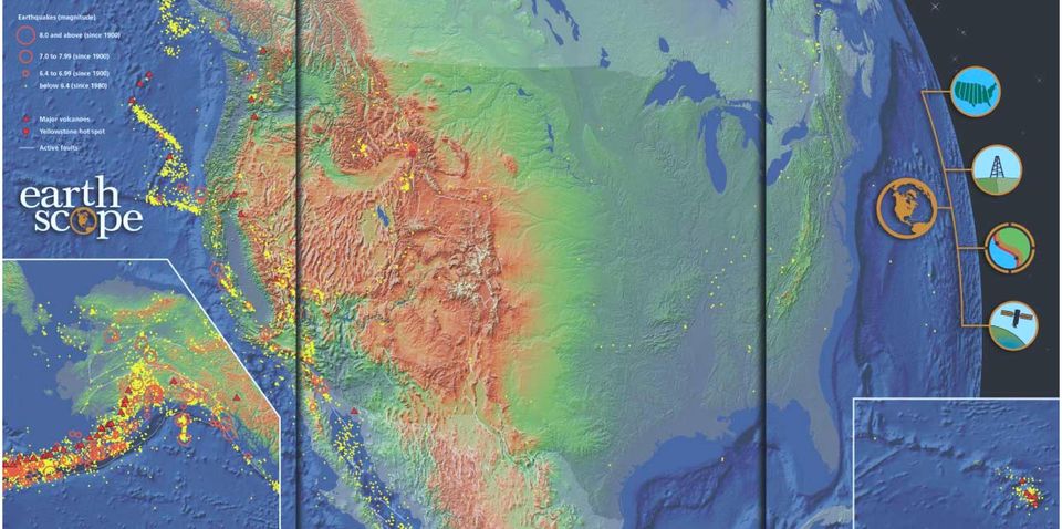
7 Deep within an active fault zone, the San Andreas Fault Observatory at Depth (SAFOD) will measure changes in rock properties before, during and after earthquakes. Linked to other EarthScope measurements at the surface, these direct observations will, for the first time, monitor how an active fault and its environment respond to regional and local changes in stress. Recorded over a decade, this combination of measurements will provide important new insights on earthquake nucleation and rupture. The face of North America reflects the variety of geological forces that have sculpted our continent. Active volcanoes and earthquake zones continue to shape the rugged and geologically young mountain ranges of Hawaii, many of the western states and Alaska. In the east, the remnants of old and eroded mountain ranges border the coastline, and scattered pockets of earthquake activity testify to the ongoing deformation of the continental interior. Written in the sediments and structures of the Great Plains is a complex history of even older cycles of deformation and erosion. EarthScope will create a linked infrastructure for a continent-scale observatory of remote sensing geophysical instruments to probe deep beneath the surface, illuminate the underlying structure of the continent and help understand the processes that continue to build and change the North American continent. The backbone of the Plate Boundary Observatory is an array of permanent stations equipped with global positioning satellite receivers and strainmeters, extending along the western margin of North America from Mexico to Alaska. In the conterminous US and Alaska, existing sites (orange) will be augmented with 800 new sites (black) to provide continuous observations at a spacing of approximately 150 km. Complete coverage of the plate boundary will require collaborative programs to install stations (gray) in Canada and Mexico. Clusters of additional instruments will be installed on volcanoes, along the San Andreas system and near other major faults, to provide increased resolution in areas of rapid deformation. At the core of USArray will be a transportable array of 400 instruments that will gradually roll across the entire US over a ten-year period, making observations for one to two years at some 2000 sites. A permanent network of approximately 120 stations will provide long-term continuity, linking together data from the temporary deployments. Additional high-resolution instruments will permit special experiments in areas of particular geological interest.

8 EarthScope components 0 NW Drill Site SE USArray (United States Seismic Array) USArray is a dense network of portable and permanent seismic stations that will allow scientists to image the details of Earth structure beneath North America. Over the course of a decade, using a rolling deployment, a transportable array of 400 broadband seismometers will cover the continent with a uniform grid of 2000 sites. As the array moves across the country, 2000 additional sensors will support highresolution investigations of key geological features. At some sites, special instruments will record electrical and magnetic fields to provide constraints on temperatures and fluid content within the lithosphere. In coordination with the US Geological Survey s Advanced National Seismic System, observatory-quality permanent stations will be installed to extend the temporal and spatial continuity of earthquake monitoring. By studying the recorded waveforms of hundreds of local, regional and global earthquakes, and large explosions from mines and quarries, scientists will be able to identify and map subtle differences in the velocity and amplitude of seismic energy traveling through Earth. These observations will result in a vastly improved ability to resolve geological structures throughout the entire crust and upper mantle and into Earth s deepest interior. INNER CORE OUTER CORE MANTLE Depth (km) Distance Along San Andreas Fault (km) SAFOD (San Andreas Fault Observatory at Depth) SAFOD is a 4-km-deep observatory drilled directly into the San Andreas fault zone near the nucleation point of the 1966 magnitude 6 Parkfield earthquake. The project will reveal the physical and chemical processes acting deep within a seismically active fault. Initially, fault-zone rocks and fluids will be retrieved for laboratory analyses, and intensive downhole geophysical measurements will be taken within and adjacent to the active fault zone. The observatory s long-term monitoring activities will include decades of detailed seismological observations of small- to moderate-sized earthquakes, and continuous measurement of pore pressure, temperature and strain during the earthquake cycle. SAFOD will provide direct information on the composition and mechanical properties of faulted rocks, the nature of stresses responsible for earthquakes, the role of fluids in controlling faulting and earthquake recurrence and the physics of earthquake initiation and growth. Drilling, sampling, downhole measurements and longterm moni- toring will allow testing of a wide range of hypotheses about faulting and earthquake generation, and the pursuit of a scientific basis for earthquake hazards assessment and prediction. 6 CRUST

9 PBO (Plate Boundary Observatory) PBO is a distributed observatory of high-precision geodetic instruments designed to image the ongoing deformation of western North America. The geodetic network will extend from the Pacific coast to the eastern edge of the Rocky Mountains, and from Alaska to Mexico. Two complementary instrumentation systems Global Positioning System (GPS) technology at about 1000 sites, and ultra-low-noise strainmeters at 200 locations will provide superior time resolution. A sparse GPS network at km spacing, connecting about 20 dense clusters located at active volcanoes and the most active earthquake faults, will provide complete spatial coverage. PBO will significantly improve our ability to image and characterize the slow deformation that accompanies earthquakes and volcanic events. These data will elucidate the poorly understood processes that precede earthquakes and volcanic eruptions, and could provide a firm basis for their prediction. The broad geographic coverage will permit quantitative understanding of tantalizing connections observed between activity in different regions. Complementary geological investigations will link present-day deformation to longer-term processes that have shaped the plate-boundary region. Juan de Fuca Plate North American Plate InSAR (Interferometric Synthetic Aperture Radar) InSAR is a dedicated, science-driven satellite mission that will provide dense spatial (30 to 100 m) and temporal (every 8 days) measurements of the North American and Pacific plates as they move past each other and deform the surrounding regions. Precise comparisons of images acquired at different times (repeat-pass interferometry) can reveal differential horizontal and vertical motions accurate to 1 mm over all terrain types. This new radar imagery, in concert with PBO s continuous GPS and strainmeter measurements, will enable mapping of surface displacements before, during and after earthquakes and volcanic eruptions, providing insights into fault mechanics and earthquake rupture. InSAR will enable mapping of earthquake strain accumulation across broad, actively deforming zones, highlighting regions of highest risk for future earthquakes. InSAR will permit imaging of the location and migration of magma through a volcanic system that may lead to an eruption, and will also provide a tool for mapping subsidence induced by petroleum production and ground water withdrawal. Pacific Plate Caribbean Cocos Plate Plate 7

10 anticipated results As a large-scale national program, EarthScope can catalyze solid Earth science research and substantially contribute to our understanding of North American geology. The scientific and organizational structure underlying this multidisciplinary effort can serve as an umbrella for Earth science studies of continental structure, dynamics and evolution, and the deeper Earth. Advances in facilities, techniques, theory and data integration have made, and will continue to make, dramatic progress possible. An exciting aspect of the EarthScope initiative is the prospect of unanticipated discovery, the unveiling of results and insights that we cannot yet imagine. EarthScope will unravel the structure, evolution and dynamics of North America. probe the behavior of active fault systems. study the details of the earthquake nucleation and rupture process. advance our understanding of natural hazards. explore the inner workings of volcanoes, and magmatic processes leading to eruption. investigate the relationship between mantle structure and dynamics, and crustal tectonics, and between tectonics and fluids in the crust. stimulate the investigation of entire geosystems through broad, integrated studies across the Earth Sciences. integrate observations and results, manage vast arrays of data, and provide easy access to tools for manipulation and visualization of those data. build upon existing partnerships between the academic Earth science community and many other organizations including NSF, USGS, NASA, DOE, regional seismic networks, state geological surveys and university consortia. 8

11 benefits and applications While EarthScope s principal scientific goal is to increase understanding of North America s structure, dynamics and evolution, the data to be collected through this initiative will have numerous practical applications and benefits. geological hazards mitigation The plate boundary of western North America the San Andreas fault system, the Cascadia and Aleutian subduction zones, and the Intermountain seismic belt includes significant regions of earthquake, volcanic and landslide hazards. All EarthScope components will provide data that bear directly on the assessment and mitigation of the risks from these hazards. These data will advance our knowledge of the mechanics of volcanic eruption and earthquake generation, and increase the possibility of earthquake prediction. resource exploration and management As USArray crosses the nation, there will be opportunities for EarthScope scientists to interact with federal and state agencies involved in regional mapping, education, public policy and resource assessment. The high-resolution component of USArray will be an important tool for probing the geological framework of the continental crust and the structural details of sedimentary basins. Subsurface maps, developed from various types of geological investigations and merged with highresolution seismic images, will be an invaluable resource in collaborative and multidisciplinary research projects aimed at a wide range of topics related to the assessment and exploitation of groundwater, mineral and energy resources. education and outreach With widespread public interest in earthquakes, volcanoes and the environment, a highly visible, science-driven initiative such as EarthScope is a natural vehicle to enhance Earth science education at all levels. Students will be encouraged to work with real data and participate in the exploration that underlies the EarthScope initiative. Outreach programs will engage communities as EarthScope facilities are established in different parts of the country. Involving the public in Earth science research will increase appreciation of how research can lead to improvements in understanding of the environment and a better quality of life. EarthScope s outreach program will bring the goals and results of EarthScope to the public, locally and nationally, through use of a full spectrum of media, including the www, TV, museums and print; provide schools and museums with live feeds to data and products; develop educational materials to help integrate these data into standard curricula and special projects. 9

12 EarthScope is a partnership extending throughout the Earth science community, including more than 100 universities, the National Science Foundation, US Geological Survey, National Aeronautics and Space Administration, Department of Energy, regional seismic networks and state geological surveys. This brochure was prepared by the EarthScope Working Group, April Editing and design by Geosciences Professional Services, Inc. Centerpiece map by Equator Graphics.

Regents Questions: Plate Tectonics
 Earth Science Regents Questions: Plate Tectonics Name: Date: Period: August 2013 Due Date: 17 Compared to the oceanic crust, the continental crust is (1) less dense and more basaltic (3) more dense and
How Did These Ocean Features and Continental Margins Form?
 298 10.14 INVESTIGATION How Did These Ocean Features and Continental Margins Form? The terrain below contains various features on the seafloor, as well as parts of three continents. Some general observations
TECTONICS ASSESSMENT
 Tectonics Assessment / 1 TECTONICS ASSESSMENT 1. Movement along plate boundaries produces A. tides. B. fronts. C. hurricanes. D. earthquakes. 2. Which of the following is TRUE about the movement of continents?
Georgia Performance Standards Framework for Science Grade 6. Unit Organizer: Geology: Inside the Earth (Approximate Time: 7 Weeks)
") The following instructional plan is part of a GaDOE collection of Unit Frameworks, Performance Tasks, examples of Student Work, and Teacher Commentary. Many more GaDOE approved instructional plans are
The following instructional plan is part of a GaDOE collection of Unit Frameworks, Performance Tasks, examples of Student Work, and Teacher Commentary. Many more GaDOE approved instructional plans are
DYNAMIC CRUST: Unit 4 Exam Plate Tectonics and Earthquakes
 DYNAMIC CRUST: Unit 4 Exam Plate Tectonics and Earthquakes NAME: BLOCK: DATE: 1. Base your answer to the following question on The block diagram below shows the boundary between two tectonic plates. Which
Interactive Plate Tectonics
 Interactive Plate Tectonics Directions: Go to the following website and complete the questions below. http://www.learner.org/interactives/dynamicearth/index.html How do scientists learn about the interior
Transform Boundaries
 Lecture 7 Plates and Mantle Plumes Transform Boundaries Transform boundaries occur where one segment of rigid lithosphere slides horizontally past another in response to stresses in the lithosphere. The
Hot Spots & Plate Tectonics
 Hot Spots & Plate Tectonics Activity I: Hawaiian Islands Procedures: Use the map and the following information to determine the rate of motion of the Pacific Plate over the Hawaiian hot spot. The volcano
Geol 101: Physical Geology PAST EXAM QUESTIONS LECTURE 4: PLATE TECTONICS II
 Geol 101: Physical Geology PAST EXAM QUESTIONS LECTURE 4: PLATE TECTONICS II 4. Which of the following statements about paleomagnetism at spreading ridges is FALSE? A. there is a clear pattern of paleomagnetic
Georgia Performance Standards Framework for Shaky Ground 6 th Grade
 The following instructional plan is part of a GaDOE collection of Unit Frameworks, Performance Tasks, examples of Student Work, and Teacher Commentary. Many more GaDOE approved instructional plans are
II. Earth Science (Geology) Section (9/18/2013)
 Section (9/18/2013)") EAPS 100 Planet Earth Lecture Topics Brief Outlines II. Earth Science (Geology) Section (9/18/2013) 1. Interior of the Earth Learning objectives: Understand the structure of the Earth s interior crust,
EAPS 100 Planet Earth Lecture Topics Brief Outlines II. Earth Science (Geology) Section (9/18/2013) 1. Interior of the Earth Learning objectives: Understand the structure of the Earth s interior crust,
Tectonic plates push together at convergent boundaries.
 KEY CONCEPT Plates converge or scrape past each other. BEFORE, you learned Plates move apart at divergent boundaries In the oceans, divergent boundaries mark where the sea floor spreads apart On land,
Plate Tectonics: Ridges, Transform Faults and Subduction Zones
 Plate Tectonics: Ridges, Transform Faults and Subduction Zones Goals of this exercise: 1. review the major physiographic features of the ocean basins 2. investigate the creation of oceanic crust at mid-ocean
Plate Tectonics Practice Questions and Answers Revised August 2007
 Plate Tectonics Practice Questions and Answers Revised August 2007 1. Please fill in the missing labels. 2. Please fill in the missing labels. 3. How many large plates form the outer shell of the earth?
FOURTH GRADE PLATE TECTONICS 1 WEEK LESSON PLANS AND ACTIVITIES
 FOURTH GRADE PLATE TECTONICS 1 WEEK LESSON PLANS AND ACTIVITIES PLATE TECTONIC CYCLE OVERVIEW OF FOURTH GRADE VOLCANOES WEEK 1. PRE: Comparing different structures of volcanoes. LAB: Modeling three types
CHAPTER 6 THE TERRESTRIAL PLANETS
 CHAPTER 6 THE TERRESTRIAL PLANETS MULTIPLE CHOICE 1. Which of the following is NOT one of the four stages in the development of a terrestrial planet? 2. That Earth, evidence that Earth differentiated.
Plate Tectonics: Big Ideas. Plate Tectonics. Plate Tectonics. The unifying concept of the Earth sciences.
 Plate Tectonics: Big Ideas Our understanding of Earth is continuously refined. Earth s systems are dynamic; they continually react to changing influences from geological, hydrological, physical, chemical,
Investigation 6: What happens when plates collide?
 Tectonics Investigation 6: Teacher Guide Investigation 6: What happens when plates collide? In this activity, students will use the distribution of earthquakes and volcanoes in a Web GIS to learn about
Plate Tectonics Web-Quest
 Plate Tectonics Web-Quest Part I: Earth s Structure. Use the following link to find these answers: http://www.learner.org/interactives/dynamicearth/structure.html 1. Label the layers of Earth in the diagram
FIFTH GRADE PLATE TECTONICS 1 WEEK LESSON PLANS AND ACTIVITIES
 FIFTH GRADE PLATE TECTONICS 1 WEEK LESSON PLANS AND ACTIVITIES PLATE TECTONIC CYCLE OVERVIEW OF FIFTH GRADE VOLCANOES WEEK 1. PRE: Exploring the rocks produced by volcanoes. LAB: Comparing igneous rocks.
Continental Drift, Sea Floor Spreading and Plate Tectonics
 Page 1 of 13 EENS 1110 Tulane University Physical Geology Prof. Stephen A. Nelson Continental Drift, Sea Floor Spreading and Plate Tectonics This page last updated on 26-Aug-2015 Plate Tectonics is a theory
6.E.2.2 Plate Tectonics, Earthquakes and Volcanoes
 Name: Date: 1. The road shown below was suddenly broken by a natural event. 3. The convergence of two continental plates would produce Which natural event most likely caused the crack in the road? island
4. Plate Tectonics II (p. 46-67)
") 4. Plate Tectonics II (p. 46-67) Seafloor Spreading In the early 1960s, samples of basaltic ocean crust were dredged up from various locations across the ocean basins. The samples were then analyzed to
4. Plate Tectonics II (p. 46-67) Seafloor Spreading In the early 1960s, samples of basaltic ocean crust were dredged up from various locations across the ocean basins. The samples were then analyzed to
Earthquakes and Plate Boundaries Deborah Jordan and Samuel Spiegel
 Earthquakes and Plate Boundaries Deborah Jordan and Samuel Spiegel Jordan, Deborah and Spiegel, Samuel: Learning Research Development Center, University of Pittsburgh. Earthquakes and Plate Boundaries.
The Next Generation Science Standards (NGSS) Correlation to. EarthComm, Second Edition. Project-Based Space and Earth System Science
 Correlation to. EarthComm, Second Edition. Project-Based Space and Earth System Science") The Next Generation Science Standards (NGSS) Achieve, Inc. on behalf of the twenty-six states and partners that collaborated on the NGSS Copyright 2013 Achieve, Inc. All rights reserved. Correlation to,
The Next Generation Science Standards (NGSS) Achieve, Inc. on behalf of the twenty-six states and partners that collaborated on the NGSS Copyright 2013 Achieve, Inc. All rights reserved. Correlation to,
The Dynamic Crust 2) EVIDENCE FOR CRUSTAL MOVEMENT
 EVIDENCE FOR CRUSTAL MOVEMENT") The Dynamic Crust 1) Virtually everything you need to know about the interior of the earth can be found on page 10 of your reference tables. Take the time to become familiar with page 10 and everything
The Dynamic Crust 1) Virtually everything you need to know about the interior of the earth can be found on page 10 of your reference tables. Take the time to become familiar with page 10 and everything
1. You are about to begin a unit on geology. Can anyone tell me what geology is? The study of the physical earth I.
 PLATE TECTONICS ACTIVITY The purpose of this lab is to introduce the concept of plate tectonics and the formation of mountains. Students will discuss the properties of the earth s crust and plate tectonics.
Plate Tectonics Chapter 2
 Plate Tectonics Chapter 2 Does not include complete lecture notes. Continental drift: An idea before its time Alfred Wegener First proposed his continental drift hypothesis in 1915 Published The Origin
ES Chapter 10 Review. Name: Class: Date: Multiple Choice Identify the choice that best completes the statement or answers the question.
 Name: Class: Date: ES Chapter 10 Review Multiple Choice Identify the choice that best completes the statement or answers the question. 1. Scientists used the pattern of alternating normal and reversed
Earthquakes. Earthquakes: Big Ideas. Earthquakes
 Earthquakes Earthquakes: Big Ideas Humans cannot eliminate natural hazards but can engage in activities that reduce their impacts by identifying high-risk locations, improving construction methods, and
SIXTH GRADE PLATE TECTONICS 1 WEEK LESSON PLANS AND ACTIVITIES
 SIXTH GRADE PLATE TECTONICS 1 WEEK LESSON PLANS AND ACTIVITIES PLATE TECTONIC CYCLE OVERVIEW OF SIXTH GRADE VOLCANOES WEEK 1. PRE: Comparing the structure of different types of volcanoes. LAB: Plotting
The Earth System. The geosphere is the solid Earth that includes the continental and oceanic crust as well as the various layers of Earth s interior.
 The Earth System The atmosphere is the gaseous envelope that surrounds Earth. It consists of a mixture of gases composed primarily of nitrogen, oxygen, carbon dioxide, and water vapor. The atmosphere and
SECOND GRADE PLATE TECTONICS 1 WEEK LESSON PLANS AND ACTIVITIES
 SECOND GRADE PLATE TECTONICS 1 WEEK LESSON PLANS AND ACTIVITIES PLATE TECTONIC CYCLE OVERVIEW OF SECOND GRADE VOLCANOES WEEK 1. PRE: Investigating the parts of a volcano. LAB: Comparing the parts of a
Plate Tectonics Short Study Guide
 Name: Class: Date: Plate Tectonics Short Study Guide Multiple Choice Identify the letter of the choice that best completes the statement or answers the question. 1. The existence of coal beds in Antarctica
Lesson 13: Plate Tectonics I
 Standards Addressed Lesson 13: Plate Tectonics I Overview Lesson 13 introduces students to geological oceanography by presenting the basic structure of the Earth and the properties of Earth s primary layers.
Plate Tectonics. Introduction. Boundaries between crustal plates
 Plate Tectonics KEY WORDS: continental drift, seafloor spreading, plate tectonics, mid ocean ridge (MOR) system, spreading center, rise, divergent plate boundary, subduction zone, convergent plate boundary,
Master in Earth Sciences
 Master in Earth Sciences DERDW EARTH SCIENCES MASTER IN EARTH SCIENCES The Department of Earth Sciences at ETH Zurich has been repeatedly ranked as one of the world s leading Earth Science schools. The
GENERAL SCIENCE LABORATORY 1110L Lab Experiment 9B: Tracking the Hawaiian Islands: How Fast Does the Pacific Plate Move?
 GENERAL SCIENCE LABORATORY 1110L Lab Experiment 9B: Tracking the Hawaiian Islands: How Fast Does the Pacific Plate Move? Background You know that the Earth s crustal plates are always moving, but how fast?
Plate Tectonics. Plate Tectonics The unifying concept of the Earth sciences. Continental Drift
 Plate Tectonics The unifying concept of the Earth sciences. The outer portion of the Earth is made up of about 20 distinct plates (~ 100 km thick), which move relative to each other This motion is what
Chapter 2. Plate Tectonics. Plate Tectonics: Learning Goals
 Plate Tectonics Chapter 2 Interactions at depend on the direction of relative plate motion and the type of crust. Which kind of plate boundary is associated with Earthquake activity? A. Divergent Boundary
Study Guide Questions Earth Structure and Plate Tectonics
 Study Guide Questions Earth Structure and Plate Tectonics What evidence did Alfred Wegener present in 1912 to support the idea of continental drift? Why did most geologists at the time dismiss Wegener
Chapter 8: Plate Tectonics -- Multi-format Test
 Name: Class: Date: ID: A Chapter 8: Plate Tectonics -- Multi-format Test Modified True/False Indicate whether the statement is true or false. If false, change the identified word or phrase to make the
Earth Egg Model Teacher Notes
 Ancient Greeks tried to explain earthquakes and volcanic activity by saying that a massive bull lay underground and the land shook when it became angry. Modern theories rely on an understanding of what
Plate tectonics states that the Earth's crust and upper mantle are broken into sections, called plates.
 Notes on Plate Tectonics Plate tectonics states that the Earth's crust and upper mantle are broken into sections, called plates. These plates move around the mantle. Plates are composed of the crust and
1. The diagram below shows a cross section of sedimentary rock layers.
 1. The diagram below shows a cross section of sedimentary rock layers. Which statement about the deposition of the sediments best explains why these layers have the curved shape shown? 1) Sediments were
Rocks and Plate Tectonics
 Name: Class: _ Date: _ Rocks and Plate Tectonics Multiple Choice Identify the choice that best completes the statement or answers the question. 1. What is a naturally occurring, solid mass of mineral or
Using GPS Data to Learn about Tectonic Plate Movement, Earthquakes, Volcanoes, and Other Applications: Ideas for Teaching
 Using GPS Data to Learn about Tectonic Plate Movement, Earthquakes, Volcanoes, and Other Applications: Ideas for Teaching Shelley Olds UNAVCO February 11, 2008 URLs UNAVCO Data for Educators http://www.unavco.org/edu_outreach/data.html
PLATE TECTONICS EXERCISE (Modified from North Seattle Community College online exercise)
") PLATE TECTONICS EXERCISE (Modified from North Seattle Community College online exercise) Introduction: As discussed in our textbook, the speed at which tectonic plates move has been calculated in several
PLATE TECTONICS EXERCISE (Modified from North Seattle Community College online exercise) Introduction: As discussed in our textbook, the speed at which tectonic plates move has been calculated in several
Glossary. continental crust: the sections of crust, the outermost layer of the earth, that include the continents
 aftershock: an earthquake that follows a larger earthquake or main shock and originates in or near the rupture zone of the larger earthquake. Generally, major earthquakes are followed by a number of aftershocks
Step 2: Learn where the nearest divergent boundaries are located.
 What happens when plates diverge? Plates spread apart, or diverge, from each other at divergent boundaries. At these boundaries new ocean crust is added to the Earth s surface and ocean basins are created.
College of Science and Health ENVIRONMENTAL SCIENCE & GEOGRAPHY Course Outline
 College of Science and Health ENVIRONMENTAL SCIENCE & GEOGRAPHY Course Outline 1. TITLE OF COURSE AND COURSE NUMBER: General Geology ENV 115, 4 credits 2. DESCRIPTION OF THE COURSE: Includes the study
Continental Drift. Alfred Wegener (1880-1930) Proposed that all of the continents were once part of a large supercontinent - Pangaea Based on:
 Proposed that all of the continents were once part of a large supercontinent - Pangaea Based on:") Plate Tectonics and Continental Drift Continental Drift Alfred Wegener (1880-1930) Proposed that all of the continents were once part of a large supercontinent - Pangaea Based on: Similarities in shorelines
Plate Tectonics and Continental Drift Continental Drift Alfred Wegener (1880-1930) Proposed that all of the continents were once part of a large supercontinent - Pangaea Based on: Similarities in shorelines
Evolving a new Geodetic Positioning Framework: An Australian Perspective
 Evolving a new Geodetic Positioning Framework: An Australian Perspective G. Johnston, J. Dawson Outline Introduction Precise Positioning National Geospatial Reference Systems Asia Pacific Reference Frame
Earthquake Hazards and Risks
 Page 1 of 7 EENS 3050 Tulane University Natural Disasters Prof. Stephen A. Nelson Earthquake Hazards and Risks This page last updated on 28-Aug-2013 Earthquake Risk Many seismologists have said that "earthquakes
The interior of the Earth is divided into layers based on chemical and physical properties.
 Plate Tectonics Lecture Notes: Slide 1. Title Slide Slide 2. The interior of the Earth is divided into layers based on chemical and physical properties. The Earth has an outer silica-rich, solid crust,
Plate Tectonics. Learning Guide. Pacific Plate. Pacific Ocean. Divergent boundaries
 Plate Tectonics Learning Guide North American Plate Eurasian Plate Arabian Plate Pacific Plate Atlantic Ocean Pacific Ocean Cocos Plate Nazca Plate South American Plate African Plate Convergent boundary
Using Google Earth to Explore Plate Tectonics
 Using Google Earth to Explore Plate Tectonics Laurel Goodell, Department of Geosciences, Princeton University, Princeton, NJ 08544 laurel@princeton.edu Inspired by, and borrows from, the GIS-based Exploring
Rapid Changes in Earth s Surface
 TEKS investigate rapid changes in Earth s surface such as volcanic eruptions, earthquakes, and landslides Rapid Changes in Earth s Surface Constant Changes Earth s surface is constantly changing. Wind,
Dip is the vertical angle perpendicular to strike between the imaginary horizontal plane and the inclined planar geological feature.
 Geological Visualization Tools and Structural Geology Geologists use several visualization tools to understand rock outcrop relationships, regional patterns and subsurface geology in 3D and 4D. Geological
Crossing the Pacific Bathymetry
 Crossing the Pacific Bathymetry Summary What is really under the salt water in our worldwide oceans? This four-part activity will guide students to explore, investigate, and analyze our mysterious ocean
Introduction and Origin of the Earth
 Page 1 of 5 EENS 1110 Tulane University Physical Geology Prof. Stephen A. Nelson Introduction and Origin of the Earth This page last updated on 30-Jul-2015 Geology, What is it? Geology is the study of
Unit 6 Earthquakes and Volcanoes
 Unit 6 Earthquakes and Volcanoes Earthquakes and Volcanoes: Essential Questions What evidence can students observe that the Earth is changing? How do scientists know what s inside the Earth? What processes
Earth Science Chapter 14 Section 2 Review
 Name: Class: Date: Earth Science Chapter 14 Section Review Multiple Choice Identify the choice that best completes the statement or answers the question. 1. Which of the following is NOT one of the three
EARTHQUAKE PREDICTION
 Lecture 15 Earthquake Prediction EARTHQUAKE PREDICTION To successfully predict an earthquake we would like to know:- PLACE TIME MAGNITUDE (rather like a weather forecast) 1 Evidence must be integrated
[Geology Layers of the Earth] [Basic: Grade 2-3] [Advanced: Grade 5: Introduction to Plate Tectonics}
![[Geology Layers of the Earth] [Basic: Grade 2-3] [Advanced: Grade 5: Introduction to Plate Tectonics}](/thumbs/40/21755359.jpg "[Geology Layers of the Earth] [Basic: Grade 2-3] [Advanced: Grade 5: Introduction to Plate Tectonics}") [Geology Layers of the Earth] [Basic: Grade 2-3] [Advanced: Grade 5: Introduction to Plate Tectonics} BACKGROUND Scientists and geologists have been able to do some drilling on Earth. They are also able
[Geology Layers of the Earth] [Basic: Grade 2-3] [Advanced: Grade 5: Introduction to Plate Tectonics} BACKGROUND Scientists and geologists have been able to do some drilling on Earth. They are also able
Magnitude 8.8 OFFSHORE MAULE, CHILE
 A great 8.8-magnitude struck central Chile early Saturday. The quake hit 200 miles (325 kilometers) southwest of the capital Santiago. The epicenter was just 70 miles (115 kilometers) from Concepcion,
Assignment #3: Plate Tectonics
 Assignment #3: Plate Tectonics Overview: In this assignment we will examine the ideas of continental drift and of sea-floor spreading that lead to the Theory of Plate Tectonics. This assignment is in two
The Southern California Earthquake Center Information Technology Research Initiative
 The Southern California Earthquake Center Information Technology Research Initiative Toward a Collaboratory for System-Level Earthquake Science Tom Jordan USC Kim Olsen - UCSB 4th Meeting of the US-Japan
Plate Tectonics. Earth, 9 th edition Chapter 2
 1 Plate Tectonics Earth, 9 th edition Chapter 2 2 3 4 5 6 7 8 9 10 11 12 13 14 15 16 Plate Tectonics: summary in haiku form Alfred Wegener gave us Continental Drift. Fifty years later... Continental Drift
Student Exploration: Plate Tectonics
 Name: Date: Student Exploration: Plate Tectonics Vocabulary: collisional boundary, convergent boundary, crust, divergent boundary, earthquake, lithosphere, mantle, plate, plate tectonics, transform boundary,
Physical Sciences, Mathematics & Engineering Division Earth & Space Sciences Program
 Physical Sciences, Mathematics & Engineering Division Earth & Space Sciences Program Geology 20: General Oceanography ONLINE An Introduction to Geological and Physical Oceanography Fall Quarter, 2015 GEOL
Name: Period: # Plate Tectonics. Journey to the center of the Earth
 Plate Tectonics Journey to the center of the Earth Use pages 124 129 to answer the following questions. Exploring Inside Earth (p. 125-126) 1. What are the two main types of evidence that Geologist use
Chapter Overview. Bathymetry. Measuring Bathymetry. Echo Sounding Record. Measuring Bathymetry. CHAPTER 3 Marine Provinces
 Chapter Overview CHAPTER 3 Marine Provinces The study of bathymetry charts ocean depths and ocean floor topography. Echo sounding and satellites are efficient bathymetric tools. Most ocean floor features
EarthScope Science Plan
 EarthScope Science Plan 1 Process Original EarthScope Science workshop: October 10-12, 2001, Snowbird UT. Implementation of EarthScope MREFC: 2004-2008 Workshop for an EarthScope Science Plan (WESP): October
European Plate Observing System: a Long-term Integration Plan for Solid Earth Sciences
 European Plate Observing System: a Long-term Integration Plan for Solid Earth Sciences Massimo Cocco & EPOS PP Team AAAS 2011 Meeting Washington DC February 2011 INGV What is EPOS? EPOS is a long-term
Tectonic plates have different boundaries.
 KEY CONCEPT Plates move apart. BEFORE, you learned The continents join and break apart The sea floor provides evidence that tectonic plates move The theory of plate tectonics helps explain how the plates
FIRST GRADE PLATE TECTONICS 1 WEEK LESSON PLANS AND ACTIVITIES
 FIRST GRADE PLATE TECTONICS 1 WEEK LESSON PLANS AND ACTIVITIES PLATE TECTONIC CYCLE OVERVIEW OF FIRST GRADE VOLCANOES WEEK 1. PRE: Learning the shapes of volcanoes. LAB: Experimenting with "lava." POST:
Layers of the Earth s Interior
 Layers of the Earth s Interior 1 Focus Question How is the Earth like an ogre? 2 Objectives Explain how geologists have learned about the interior of the Earth. Describe the layers of the Earth s interior.
Geology 3120 - Structural Geology A capstone course
 Geology 3120 - Structural Geology A capstone course a culminating experience in which students synthesize subject-matter knowledge they have acquired, integrate cross-disciplinary knowledge, and connect
Plate Tectonics Lab. Continental Drift. The Birth of Plate Tectonics
 Plate Tectonics Lab Continental Drift Take a look at a globe sometime and observe the remarkable fit between South America and Africa. Could they have, in fact, been connected? During the 19th and early
California Standards Grades 9 12 Boardworks 2009 Science Contents Standards Mapping
 California Standards Grades 912 Boardworks 2009 Science Contents Standards Mapping Earth Sciences Earth s Place in the Universe 1. Astronomy and planetary exploration reveal the solar system s structure,
Volcanoes Erupt Grade 6
 TEACHING LEARNING COLLABORATIVE (TLC) EARTH SCIENCE Volcanoes Erupt Grade 6 Created by: Debra McKey (Mountain Vista Middle School); Valerie Duncan (Upper Lake Middle School); and Lynn Chick (Coyote Valley
Alfred Wegener s Theory of Continental Drift Became Modern Plate Tectonics. Wegener in Greenland about 1912. He froze to death there in 1930.
 Alfred Wegener s Theory of Continental Drift Became Modern Plate Tectonics Wegener in Greenland about 1912. He froze to death there in 1930. Science is self correcting. The Scientific Method The history
KINDERGARTEN PLATE TECTONICS 1 WEEK LESSON PLANS AND ACTIVITIES
 KINDERGARTEN PLATE TECTONICS 1 WEEK LESSON PLANS AND ACTIVITIES PLATE TECTONIC CYCLE OVERVIEW OF KINDERGARTEN VOLCANOES WEEK 1. PRE: Learning that all mountains are not volcanoes. LAB: Investigating rocks
Layers of the Earth and Plate Tectonics
 Layers of the Earth and Plate Tectonics Objectives: explain various ways the earth can be changed by natural forces define the term Geology define the terms Crust, Mantle, Outer Core and Inner Core classify
Chapter 5: Earthquakes
 Chapter 5: Earthquakes 1. Experiencing an Earthquake firsthand 2. The Science of Ghost Forests and Megaearthquakes 3. Faults, Earthquakes, and Plate Tectonics 4. Seismic Waves and Earthquake Detection
Engaging Students Through Interactive Activities In General Education Classes
 Engaging Students Through Interactive Activities In General Education Classes On the Cutting Edge: Early Career Geoscience Faculty Workshop 14-18 June 2009 Presented by Randy Richardson Department of Geosciences,
Europa and Titan: Oceans in the Outer Solar System? Walter S. Kiefer, Lunar and Planetary Institute, Houston TX
 Europa and Titan: Oceans in the Outer Solar System? Walter S. Kiefer, Lunar and Planetary Institute, Houston TX Biologists believe that life requires the presence of some sort of liquid to serve as a medium
Magnitude 7.2 GUERRERO, MEXICO
 A powerful magnitude-7.2 earthquake shook central and southern Mexico on Friday. The earthquake occurred at a depth of 24 km (15 miles). Its epicenter was in the western state of Guerrero, near the seaside
Plate Tectonics PuzzleMap User Guide
 About this Product: Plate tectonics is a key standards-based topic taught in earth science classrooms throughout the United States. The purpose of this map is to help educators (teachers, museum tour guides,
Sedimentary Basins. Revision Material. Introduction. CE3A8 SMJ Geology for Engineers 1
 CE3A8 SMJ Geology for Engineers 1 Sedimentary Basins Revision Material This handout lists the topics covered in the two lectures on sedimentary basins and provides a few key diagrams. Either of the following
Geoscientists follow paths of exploration and discovery in quest of solutions to some of society's most challenging problems.
 Page 1 of 5 Geoscientists follow paths of exploration and discovery in quest of solutions to some of society's most challenging problems. Predicting the behavior of Earth systems and the universe. Finding
PACIFIC TSUNAMI: CONTINUING RESEARCH AND FORMATION OF A MUSEUM EXHIBIT
 PACIFIC TSUNAMI: CONTINUING RESEARCH AND FORMATION OF A MUSEUM EXHIBIT Melissa Ann Meiner Geology/Marine Science Department University of Hawai i at Hilo Hilo, HI 96720 ABSTRACT The Sumatran tsunami was
Chapter 7 Earthquake Hazards Practice Exam and Study Guide
 Chapter 7 Earthquake Hazards Practice Exam and Study Guide 1. Select from the following list, all of the factors that affect the intensity of ground shaking. a. The magnitude of the earthquake b. Rather
How To Calculate Horizontal Velocity
 The Impact of Horizontal Velocity on the APFO Ground Control Database By Louise Mathews and Joan Biediger February 2, 2012 Table of Contents Abstract... 1 Introduction and Background... 2 Plate Tectonics
Earth Science Module 21. Plate Tectonics: The Earth in Motion. Plate Tectonics Module Study Notes and Outline. Creationist Model
 Earth Science Module 21 Plate Tectonics: The Earth in Motion Plate Tectonics Module Study Notes and Outline Creationist Model I. Scientists shift their paradigm A. When the data supporting plate tectonics
Seismic Waves Practice
 1. Base your answer to the following question on the diagram below, which shows models of two types of earthquake waves. Model A best represents the motion of earthquake waves called 1) P-waves (compressional
Using Remotely Sensed Data From ASTER to Look Impact of Recent Earth Quakes in Gujarat, India.
 Using Remotely Sensed Data From ASTER to Look Impact of Recent Earth Quakes in Gujarat, India. A major earth quake occurred in Gujarat, India on January 26,2000. (Origin time 03:16 GMT, Location 23.399N
Prentice Hall Interactive Science Series 2011 Correlated to: Arizona Science Standards, Strands 1-6 (Grade 7)
") Strand 1: Inquiry Process Inquiry Process establishes the basis for students learning in science. Students use scientific processes: questioning, planning and conducting investigations, using appropriate
Strand 1: Inquiry Process Inquiry Process establishes the basis for students learning in science. Students use scientific processes: questioning, planning and conducting investigations, using appropriate
Unit 4 Lesson 2 Plate Tectonics. Copyright Houghton Mifflin Harcourt Publishing Company
 Puzzling Evidence What evidence suggests that continents move? In the late 1800s, Alfred Wegener proposed his hypothesis of continental drift. According to this hypothesis, the continents once formed a