The 1913 Dayton Flood and the Birth of Modern Flood Control Engineering in the United States
|
|
|
- Agatha Briggs
- 8 years ago
- Views:
Transcription
1 The 1913 Dayton Flood and the Birth of Modern Flood Control Engineering in the United States J. David Rogers Natural Hazards Mitigation Institute University of Missouri-Rolla

2 Overview of the Dayton Area 4 rivers converge in Dayton within one mile of each other The Dayton area averaged one major flood every decade Miami River watershed covers 3,937 square miles and 115 miles of channel; feeds into the Ohio River

3 Timeline of Flood Events (1 of 7) 21 March degrees, freak windstorm begins 22 March sunny day, temperatures fall into the 20s 23 March Easter Sunday, rain begins falling on Ohio and nearby states 24 March heavy rains, at 0700 river reaches high stage for the year at 11.6 ft and continues to rise

4 Timeline of Flood Events (2 of 7) 25 March 0000: A.M. Fox contacts police after discovering weakening in Herman street levee; Dayton Police start warning sirens and alarms 0530: City Engineer Gaylord Cummin discovers water at top of levees and flowing at an unprecedented 100,000 cubic feet per second

5 Timeline of Flood Events (3 of 7) 25 March 0600: water appears in Dayton streets after levees begin to overtop 0800: levees on south side fail, begin flooding downtown business district

6 Timeline of Flood Events (4 of 7) 25 March water levels continue to rise throughout Dayton

7 Timeline of Flood Events (5 of 7) 26 March - flood waters reach their crest at 0130

8 Timeline of Flood Events (6 of 7) 26 March early morning gas explosion at 5 th and Wilkinson (photos taken after water receded)

9 Timeline of Flood Events (7 of 7) 26 March panoramic image of Dayton along the swollen Miami River at 1030 (looking North)
")
10 Flood Destruction- Casualties 700 people died in storm event (467 in Ohio and about 300 from Dayton) 1400 horses and 2000 other domestic animals died in flood.

11 Wood Frame Houses Decimated; lifted off foundations and Tumbled About

12 Flotsam punctures structures

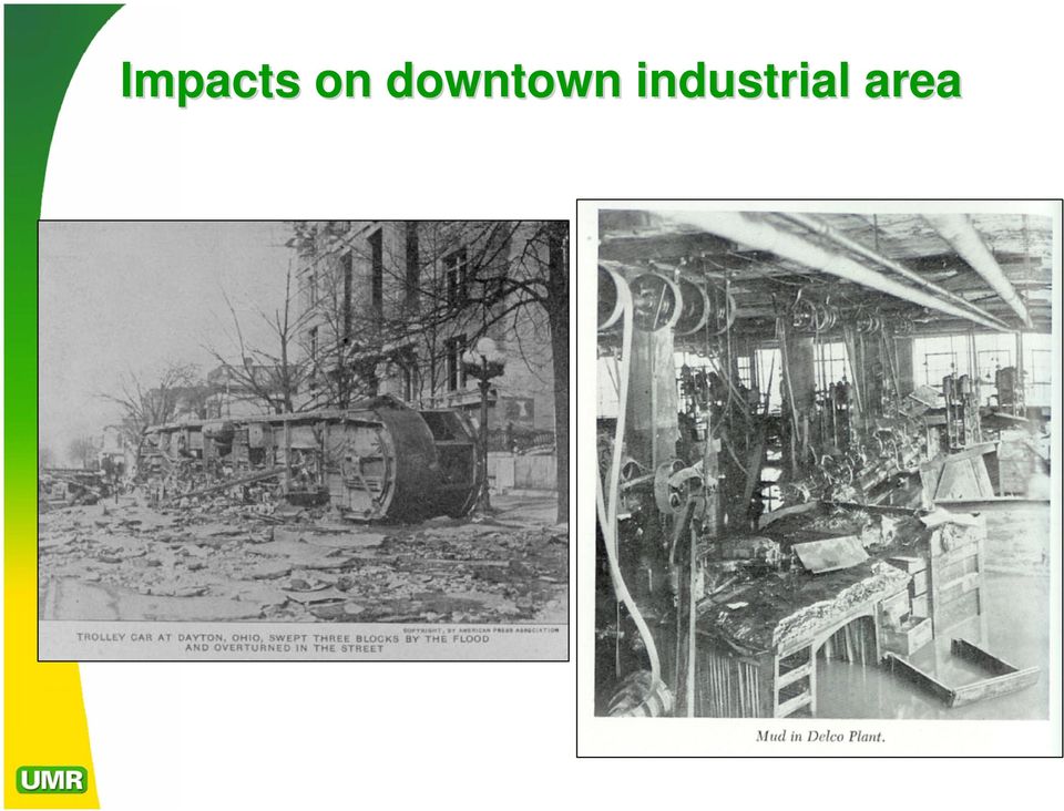
13 Impacts on downtown industrial area
14 Flood Recovery - 1 The physical recovery took about a year; but the business recovery took about 10 years

15 Flood Recovery - 2 The Ohio National Guard constructed refugee camps until people could be resettled or relocated.

16 Flood Protection Campaign -1 Some part of the Ohio flooded every year from 1873 to 1913 Engineers did not have an accepted methodology for predicting the maximum probable flood Levees were the primary form of flood control up to 1913 Dams scared people after the 1889 Johnstown Dam disaster Flood control was still considered a local or state problem Most of downtown Dayton was built on the Miami River s s natural floodplain

17 Flood Protection Campaign - 2 The City of Dayton vowed that their city would never flood again On 27 March, Governor James Cox appointed a Citizens Relief Commission On 2 May, the Commission began a 10 day fundraiser which raised over $2 million (1913 dollars) from 23,000 subscribers The Commission hired Arthur E. Morgan to head the flood control program

18 Arthur E. Morgan ( ) 1975) Arthur E. Morgan, C.E. Born Cincinnati, OH; grew up in St. Cloud, MN Worked various jobs out west and attended the University of Colorado for 6 weeks Worked for his father s s engineering practice; drafted engineering code for the State of Minnesota Married twice; 2 sons and 3 daughters Moved to Dayton, OH in 1913 President of Antioch College, Oversaw creation of the Pueblo (Colorado) Conservation District after 1921 Pueblo flood First Chairman of the Tennessee Valley Authority ( ) 38) Committed to social reform and scientific methods Lifelong critic of the Corps of Engineers; wrote book Dams and Disasters (1973) Lived to be 97
 38) Committed to social reform and scientific methods Lifelong")
19 Morgan s s Flood Protection Plan - 1 Morgan was literally given carte blanche: The valley has suffered a calamity that must never be allowed to occur again. Find a way out. He hires 50 engineers to determine the size the Miami Valley watershed and determine the flood volume. Used historical data from Europe to estimate that 1000 year recurrence frequency floods are 20% larger than 100 or 200 year frequency events. 03 October 1913, Morgan presents eight different plans to the city.

20 Flood Protection Plan - 2 After much debate, the City of Dayton decided on building a system of dry reservoirs citing its precedence in France s s Loire Valley. Morgan s s Plan: Instream Storage: : Five earthen dams with conduits or slots to meter out a limited amount of water Training levees: : Widening channel substantially through the Dayton area and constructing large levees. Flood storage areas to be used as farmland between brief periods of flooding The New channel could convey 40% more volume than 1913 flood!

21 Flood Protection Plan - 3
22 Creation of the Miami Conservancy District In 1914, Morgan drafted the Ohio Conservancy Act which was quickly passed and signed into law The Act allowed local governments to establish conservancy districts for flood control (called flood control districts today) After much debate regarding the act s constitutionality, the Miami Conservancy District (MCD) was established on June 1915 and appointed Morgan as its first president; work immediately began on his Dayton flood control system
23 Project Construction - 1 Entire factories were removed where such features had encroached the natural river channel
24 Project Construction - 2 Business and industries which encroached the 1000 year flow channel were razed and relocated The channel of the Miami River was restored to its maximum cross section
25 Project Construction - 3
26 Project Construction - 4
27 Embankment Flood Storage Basins basically dry dams
28 GERMANTOWN DAM Germantown Dam was the largest of the five embankment dams constructed as part of the flood control project.
29 ENGLEWOOD DAM Morgan employed permanent slots, or openings, in the dams to meter outflow and prohibit between-storm storage; fearing permanent lakes would deter from the primary mission of the dams (flood control).
30 Huffman Dam Outlet Works
31 Taylorsville and Englewood Dams
32 Englewood Dam in 1993
33 Current Events in the Miami Conservancy District - 1 Mission: Healthy watersheds that support sustainable communities and a higher quality of life for our generation and those to come. Vision: Protecting the lives, property, and economic vitality by providing unfailing flood protection, preserving water resources, enhancing river corridors and conserving valuable land within the Great Miami River Watershed.
34 Current Events in the Miami Conservancy District - 2 Highest water in 2004 occurred on 05 January Germantown Basin was 45 feet above normal and at the 8 th highest level since the 1913 flood All five dams stored water during this event 2 to 5 inches of rain fell on the Miami Valley
35 The Miami Conservancy District maintains an active board of consultants Original board of consultants
36 REFERENCES Morgan, Arthur E., 1951, The Miami Conservancy District: : McGraw Hill, 504 p. Eckert, Allan W., 1965, A Time of Terror: : Landfall Press, Dayton, 341 p. Morgan, Arthur E., 1971, Dams and Other Disasters: A Century of the Army Corps of Engineers in Civil Works: : Porter Sargent,, 422 p. Talbert, Roy J., 1987, FDR s s Utopian: Arthur Morgan and the TVA: University Press of Mississippi, 218 p. Morgan, Ernest, 1991, Arthur Morgan Remembered: : Community Services, Yellow Springs, OH, 67 p. Bell, Trudy, 2004, Taking Engineering by Storm: amazing tale of the Great Easter Flood of 1913, The Bent, Tau Beta Pi, winter 2004, pp Bambakidis,, Eli., ed., 2002, 1913: Preserving the Memories of Dayton s Great Flood, Proceedings of the Symposium, Oct 22, 2002, 144 p.; Online: h.ht ml J. D. Rogers interviews with Dr. Ralph B. Peck
Repository: O Brien Library at United Theological Seminary; Center for the Evangelical and United Brethren Heritage
 Repository: O Brien Library at United Theological Seminary; Center for the Evangelical and United Brethren Heritage Location: 4501 Denlinger Rd. Trotwood, OH 45426 Telephone: (937) 529-2234 Email: Website:
Swannanoa River Flood Risk Management Study
 Swannanoa River Flood Risk Management Study Measures Evaluated to Reduce Future Flood Damages City of Asheville U.S. Army Corps of Engineers Flooding History Part of the 132 square mile Swannanoa River
Why does Kittitas County want to form a Flood Control Zone District?
 KITTITAS COUNTY DEPARTMENT OF PUBLIC WORKS Kirk Holmes, Director What is a Flood Control Zone District (FCZD)? A Kittitas County Flood Control Zone District (FCZD) would be a special-purpose government
Watersheds, Streams, & Highways: Resiliency in Disaster Recovery Through Partnerships and Innovation
 Watersheds, Streams, & Highways: Resiliency in Disaster Recovery Through Partnerships and Innovation Chris Sturm Colorado Water Conservation Board Stream Restoration Coordinator 303 866 3441 chris.sturm@state.co.us
Flood Risk Management
 Flood Risk Management Value of Flood Risk Management Every year floods sweep through communities across the United States taking lives, destroying property, shutting down businesses, harming the environment
Flood Risk Management
 Flood Risk Management Value of Flood Risk Management Value to Individuals and Communities Every year floods sweep through communities across the United States taking lives, destroying property, shutting
Flooding and Flood Threats on Trenton Island
 Mitigation Success Trenton Island, Pierce County, Wisconsin Background: Trenton Island is located in the unincorporated area of Trenton Township, Pierce County, in northwestern Wisconsin. Often called
Flood After Fire Fact Sheet
 FACT SHEET Flood After Fire Fact Sheet Risks and Protection Floods are the most common and costly natural hazard in the nation. Whether caused by heavy rain, thunderstorms, or the tropical storms, the
U.S. Army Corps of Engineers
 Walla Walla District U.S. Army Corps of Engineers Hurricane Katrina Response Briefer: Joseph Saxon Today s Briefing U.S. Army Corps of Engineers Mission Events leading up to New Orleans flooding Corp s
Assiniboine River and Lake Manitoba Basins Flood Mitigation Study: Providing Greater Protection For Manitobans From Flood Risks
 Assiniboine River and Lake Manitoba Basins Flood Mitigation Study: Providing Greater Protection For Manitobans From Flood Risks Welcome! Manitoba Infrastructure and Transportation is studying flooding
Flooding Hazards, Prediction & Human Intervention
 Page 1 of 10 EENS 3050 Tulane University Natural Disasters Prof. Stephen A. Nelson Flooding Hazards, Prediction & Human Intervention This page last updated on 19-Oct-2015 Hazards Associated with Flooding
US Army Corps of Engineers BUILDING STRONG
 Fort Worth District Public Meeting 20 August 2013 US Army Corps of Engineers Lewisville Dam - Authorization Authorized by the River and Harbor Act, approved 2 March 1945 (Public Law 14, 79th Congress,
A. Flood Management in Nevada
 Nevada Division of Water Planning A. Flood Management in Nevada Introduction Flooding has been a concern for Nevada communities since the first settlers moved to the territory in the mid-1800 s. Fourteen
Historic Flood Impact on the Nashville Drinking Water System. Scott Potter, Director Metro Water Services, Nashville, TN
 Historic Flood Impact on the Nashville Drinking Water System Scott Potter, Director Metro Water Services, Nashville, TN Historic Event = 13.53 /48 Hours May 1 6.32 of Rain = 3rd greatest one-day rainfall
USA - EVOLUTION OF POLICY ON FLOODPLAIN MANAGEMENT CASE #86
 USA - EVOLUTION OF POLICY ON FLOODPLAIN MANAGEMENT CASE #86 This case describes integrated floodplain strategies in the US, involving the participation of three levels of government and the private sector.
United States Army Corps of Engineers, Civil Works
 United States Army Corps of Engineers, Civil Works Fiscal Year 2013 Federal Program Inventory May 2013 Table of Contents Introduction... 2 Program Inventory... 3 1. Navigation... 3 2. Flood Risk Management...
Post-Flood Assessment
 Page 1 of 7 Post-Flood Assessment CHAPTER 4 AGENCY COORDINATION Agency coordination is an essential element for the operation of the flood management systems in the Central Valley. Due to the nature of
Building Resilient Infrastructure for the 21 st Century
 Building Resilient Infrastructure for the 21 st Century 1 Maria Mehranian Cordoba Corporation & Los Angeles Regional Water Quality Control Board October 19, 2014 24 th Annual Lake Arrowhead Symposium:
A Dam with a View» BETH WILSON. Displayed with permission The American Surveyor October 2014 Copyright 2014 Cheves Media www.amerisurv.
 A Dam with a View» BETH WILSON n March 1913, a devastating flood forever altered the landscape of the Ohio and Muskingum valleys. More than 400 people were killed, and thousands of homes were destroyed.
FLOOD PROTECTION AND ECOSYSTEM SERVICES IN THE CHEHALIS RIVER BASIN. May 2010. Prepared by. for the. 2010 by Earth Economics
 FLOOD PROTECTION AND ECOSYSTEM SERVICES IN THE CHEHALIS RIVER BASIN May 2010 Prepared by for the Execubve Summary The Chehalis Basin experienced catastrophic flooding in 2007 and 2009. In response, the
Appendix B REFERENCES
 Appendix B REFERENCES 2007 Field Reconnaissance Report of Bank Erosion Sites and Site Priority Ranking. Sacramento River Flood Control Levees, Tributaries and Distributaries American Red Cross. www.redcross.org
Lower Raritan Watershed Management Area Stormwater & Flooding Subcommittee Strategy Worksheet LRSW-S3C1
 Strategy Name: Reduce Existing Potential for Flood Damages LRSW-S3C1. Develop and implement a program to: Minimize flood damages through the use of structural measures. Minimize flood damages through the
Wildfire & Flash Flood Recovery NACo Justice & Public Safety Symposium January 2014
 Wildfire & Flash Flood Recovery NACo Justice & Public Safety Symposium January 2014 Fall 2013 Jim Reid Executive Director Public Service El Paso County, Colorado Recovery Specific to Incident Recovery
5.0 OVERVIEW OF FLOOD DAMAGE REDUCTION MEASURES
 5.0 OVERVIEW OF FLOOD DAMAGE REDUCTION MEASURES Flood damage reduction consists of two basic techniques structural and non-structural. Structural methods modify the flood and take the flood away from people
Henry Van Offelen Natural Resource Scientist MN Center for Environmental Advocacy hvanoffelen@mncenter.org
 Henry Van Offelen Natural Resource Scientist MN Center for Environmental Advocacy hvanoffelen@mncenter.org Wetland study slide Water Quality NRE goals in watershed plans Protect habitat that remains.
Disaster recovery response to Tropical Storm Alberto
 Barksdale, Daryl (1998 [2004]) Disaster recovery response to Tropical Storm Alberto, in Disaster Management Programs for Historic Sites, eds Dirk H. R. Spennemann & David W. Look. San Francisco and Albury:
5.14 Floodplains and Drainage/Hydrology
 I-70 East Final EIS 5.14 Floodplains and Drainage/Hydrology 5.14 Floodplains and Drainage/Hydrology This section discusses floodplain and drainage/hydrology resources and explains why they are important
The Basics of Chapter 105 Waterways and Wetlands Permitting in PA
 The Basics of Chapter 105 Waterways and Wetlands Permitting in PA April 17, 2013 Goal To develop a basic understanding of PA Department of Environmental Protection (DEP) and US Army Corps of Engineers
Appendix D Flood Damage Assessment
 Appendix D Flood Damage Assessment There is no single definition of the phrase flood-damage assessment that is applicable to all agencies. Such a definition would be difficult to develop and may be unnecessary.
The Mississippi River & Tributaries Project
 Following the Great Mississippi River Flood of 1927, the nation galvanized in its support for a comprehensive and unified system of public works within the lower Mississippi Valley that would provide enhanced
Tokyo, Japan. William L. Carwile, III FEMA Associate Administrator Response and Recovery. Most catastrophic natural disaster in United States in the
 Hurricane Katrina Long term Recovery Expert twork kgroup Meeting Tokyo, Japan May 31, 2011 William L. Carwile, III FEMA Associate Administrator Response and Recovery Hurricane Katrina August 29, 2005 Most
How to Become a Navy Engineer For $78,000 in USD
 Presentation to Associated General Contractors COL Mark Deschenes Commander US Army Corps of Engineers Rock Island District February 2014 US Army Corps of Engineers Rock Island District 78,000 Square Miles
Colorado Department of Transportation. Flood Disaster Study Committee November 5, 2013
 Colorado Department of Transportation Flood Disaster Study Committee November 5, 2013 1 Immediate Goals Restore access by December 1, 2013 Temporary repairs to restore mobility Reconnect communities Long
Jackson Gulch Outlet Canal Rehabilitation Project
 Jackson Gulch Outlet Canal Rehabilitation Project Preliminary Budgetary Estimate for Rehabilitation February 2004 Prepared for the Mancos Water Conservancy District Jackson Gulch Reservoir 42888 County
Disaster Recovery in Stages
 Disaster Recovery in Stages Reconstructing Lyons River Corridor St Vrain Creek and North/South Tributaries No Name Horseshoe Bend Two Rivers 2013 Flooding Damages: Over $50 million in damage to the Town
River Management 2013 Colorado Flood
 River Management 2013 Colorado Flood Damages, Countermeasures, Socio-Economic Impacts Miles Blair, Allen Chestnut, Hwayoung Kim, & Caroline Ubing CIVE 717 Spring 2014 Flood Statistics Sept 9 th 16 th,
CFM REVIEW COURSE September 30, 2014 Vail, CO
 CFM REVIEW COURSE September 30, 2014 Vail, CO CFM PURPOSE The primary goal of the ASFPM Certified Floodplain Manager Program (CFM Program) is to help reduce the nation s flood losses and protect and enhance
THE CITY OF MEMPHIS, TENNESSEE ACTION PLAN FOR DISASTER RECOVERY
 THE CITY OF MEMPHIS, TENNESSEE ACTION PLAN FOR DISASTER RECOVERY DRAFT FOR PUBLIC REVIEW Proposed Uses of Supplemental CDBG Disaster Recovery Grant Funding Authorized by the Supplemental Appropriations
Basic system of measures for flood damage mitigation in Japan. Preparedness for major floods
 Basic system of measures for flood damage mitigation in Japan Preparedness for major floods Past major floods and state-level efforts Role of the 2 MLIT's disaster prevention efforts Disaster prevention
Appendix A. Lists of Accomplishments and Project Costs. UMRWD 10 Year Plan Update. Appendix A UPPER MINNESOTA RIVER WATERSHED DISTRICT
 UPPER MINNESOTA RIVER WATERSHED DISTRICT Lists of Accomplishments and Project Costs 10 Year Plan Update UMRWD 10 Year Plan Update Page A 1 UMRWD LIST OF ACCOMPLISHMENTS Since its inception in 1967, the
How To Prepare For A Flood In Hampshire
 Chapter 6. Emergency Services Emergency services measures protect people during and after a flood. Locally, these measures are coordinated by the Huntsville-Madison County Emergency Management Agency.
The 1951 Kansas - Missouri Floods... Have We Forgotten?
 The 1951 Kansas - Missouri Floods... Have We Forgotten? Introduction - This report was originally written as NWS Technical Attachment 81-11 in 1981, the thirtieth anniversary of this devastating flood.
NYSDEC Optional Additional Language Model Local Law for Flood Damage Prevention Optional Additional Language
 NYSDEC General Comments. The contains language that complies with the floodplain management requirements of the National Flood Insurance Program (NFIP) contained in federal regulations 44 CFR 60.3 through
Flooding and Change on the Willamette River
 Flooding and Change on the Willamette River The Willamette River Like many rivers of the northwest the Willamette River once had a very different appearance. It was wild river and as it passed through
The Stock Market Crash of 1929, Great Depression, Dust Bowl, Franklin Roosevelt and the New Deal
 The Stock Market Crash of 1929, Great Depression, Dust Bowl, Franklin Roosevelt and the New Deal SS5H5: The Student will explain how the Great Depression and New Deal affected the lives of many Americans.
Appendix B REFERENCES
 Appendix B REFERENCES American Red Cross. www.redcross.org California Department of Finance. www.dof.ca.gov/research/. California Department of Fish and Game. www.dfg.ca.gov California Department of Forestry
Flood Plain Reclamation to Enhance Resiliency Conserving Land in Urban New Jersey
 Flood Plain Reclamation to Enhance Resiliency Conserving Land in Urban New Jersey Rutgers Cooperative Extension Water Resources Program Christopher C. Obropta, Ph.D., P.E. Email: obropta@envsci.rutgers.edu
Final Report. Dixie Creek Restoration Project. Funded by Plumas Watershed Forum
 Final Report Dixie Creek Restoration Project Funded by Plumas Watershed Forum Plumas Corporation January 2009 1 Background FR-CRM staff presented this project to the Dixie Valley Landowners Association
ECONOMIC ANALYSIS FLOOD DAMAGE REDUCTION. Lower Carmel River Floodplain Restoration and Enhancement Project
 ECONOMIC ANALYSIS FLOOD DAMAGE REDUCTION Lower Carmel River Floodplain Restoration and Enhancement Project I. Description of the Project and its Relationship to Other Projects in the Proposal The Lower
PART 2 NEW ORLEANS DRAINAGE CANALS
 PART 2 NEW ORLEANS DRAINAGE CANALS The Old Basin drainage canal was excavated in the 1790s.. This shows the systems of drainage ditches and canals established by 1829, leading to Bayou St. John. Cross
Animals in Disasters
 MODULE B UNIT 6 Animals in Disasters Recovering from a Disaster Overview Federal, State, and local governments work together in any major emergency. Emergency assistance funding is based on the concept
JOB POSTING WATER RESOURCES AND ENGINEERING FLSA CLASSIFICATION: EXEMPT SALARY RANGE: $84,400 - $131,875. OPEN PERIOD: Open until April 24, 2015
 JOB POSTING POSITION TITLE: DEPARTMENT: REPORTS TO: ENGINEERING MANAGER WATER RESOURCES AND ENGINEERING GENERAL MANAGER FLSA CLASSIFICATION: EXEMPT SALARY RANGE: $84,400 - $131,875 OPEN PERIOD: Open until
Best Practice of Flood Hazard Map in Japan
 Best Practice of Flood Hazard Map in Japan 1. Hazard map in Japan There are about 1,500 municipalities in Japan, which need to prepare flood hazard map. 510 municipalities have already made and disclosed
U.S. Army Corps of Engineers Tulsa District
 U.S. Army Corps of Engineers Tulsa District Mike Abate, PMP. Chief, Civil Works Branch, PPMD April 17, 2015 US Army Corps of Engineers Civil Works Mission Water Supply 50% of Corps water supply contracts
MANITOBA FLOOD PROTECTION PROJECTS Project Justification and Benefits. Science Imagination Collaboration
 MANITOBA FLOOD PROTECTION PROJECTS Project Justification and Benefits Science Imagination Collaboration Presentation Outline Extreme events on Red and Assiniboine Manitoba Flood Protection Works KGS Group
And Flood Resilient Design in Austin, Texas
 And Flood Resilient Design in Austin, Texas The good, the bad and the ugly; What does this video show us? Riverine Flooding versus Flash Flooding Flash Flood Alley Stretches along the I 35 corridor between
Village of Spring Valley Comprehensive Plan 2009-2029
 Chapter 8: Intergovernmental Cooperation Introduction Intergovernmental communication, coordination, and cooperation can make a significant difference in the implementation and administration of a comprehensive
FOUR RIVERS RESTORATION PROJECT
 MLTM Republic of Korea Making Every Drop Count International Workshop on Integrated Urban Water Management WATER & GREEN GROWTH FOUR RIVERS RESTORATION PROJECT Office of National River Restoration, Korea
John Keel, CPA State Auditor. An Audit Report on The Dam Safety Program at the Commission on Environmental Quality. May 2008 Report No.
 John Keel, CPA State Auditor An Audit Report on The Dam Safety Program at the Commission on Environmental Quality Report No. 08-032 An Audit Report on The Dam Safety Program at the Commission on Environmental
How To Manage Water Resources In The Yakima Basin
 Yakima Basin Integrated Water Resource Management Plan October 23, 2014 Presented by Derek Sandison, Director Office of Columbia River Photo Courtesy of Tom Ring Basin size: 6,155 sq. miles Population:
The. year. floods are
 Introduction The Ascension Parish Council is dedicated to minimizing thee loss of life and property that is associated with flooding events. Education and prevention are valuable and proven tools that
Case Study: The History of the San Juan Headwaters Forest Health Partnership
 Case Study: The History of the San Juan Headwaters Forest Health Partnership Introduction: Wildfire is a part of life in Southwest Colorado. It plays an integral role in ecosystem health and management.
HIGHLAND COUNTY OHIO WE RE OPEN FOR BUSINESS
 HIGHLAND COUNTY OHIO WE RE OPEN FOR BUSINESS Overview: Highland County is a wonderful blend of both agriculture and industry. The historic influence of farming communities carries on today with area residents
Walter Dasheno Governor Santa Clara Pueblo
 Walter Dasheno Governor Santa Clara Pueblo Testimony on Current and Future Impacts of Climate Change on the Intermountain West, including Drought, Wildfire Frequency and Severity, And Ecosystems Before
Nashville District Workload for Nashville SAME Professional Development Workshop
 Nashville District Workload for Nashville SAME Professional Development Workshop Thomas Cayce, PE Chief, Programs and Project Delivery Branch Nashville District 17 August 2011 US Army Corps of Engineers
USACE Dam Safety Program Current Approach & Methodology
 USACE Dam Safety Program Current Approach & Methodology Siamac Vaghar, PE, MASCE Chief, Geotechnical Engineering Section Dam Safety Program Manager US Army Corps of Engineers New England District Corps
Chapter 3 SENSITIVE AREAS AND VEGETATED CORRIDORS
 Chapter 3 3.01 General Provisions 3.01.1 Introduction 3.01.2 Application and Interpretation of Chapter 3.01.3 Unbuildable Lots 3.01.4 Other Permits 3.01.5 Prohibited Activities 3.02 Service Provider Letter
The Muddy River: A Century of Change
 The Muddy River: A Century of Change Tom Brady, Brookline Conservation Administrator, Tree Warden, Town Arborist 617-730-2088 or tbrady@brooklinema.gov Muddy River Flood Damage Reduction and Environmental
DISASTER COUNTERMEASURES BASIC ACT
 (Provisional Translation) DISASTER COUNTERMEASURES BASIC ACT June 1997 National Land Agency, Japan DISASTER COUNTERMEASURES BASIC ACT (Act No. 223, November 15, 1961) Table of Contents Chapter I. General
ALBUQUERQUE EMERGENCY OPERATIONS PLAN ANNEX 8 DAMAGE ASSESSMENT AND REPORTING
 ALBUQUERQUE EMERGENCY OPERATIONS PLAN ANNEX 8 DAMAGE ASSESSMENT AND REPORTING PRIMARY RESPONSIBILITY Albuquerque City and Bernalillo County Government SECONDARY RESPONSIBILITY Department of Public Safety,
Urban Stream Restoration Defining the Full Benefits of a Project. Warren C. High MACTEC Engineering and Consulting
 Urban Stream Restoration Defining the Full Benefits of a Project Warren C. High MACTEC Engineering and Consulting Economics in the Decision Process Return on Investment Willingness to Pay Municipal Growth
Using probability to understand 100-year storms
 1 + Using probability to understand 100-year storms Grade Level: 5-7 Activity Duration: 30-45 minutes Overview: I. Storm stories II. 100-year Storm Probability III. Delineating Storms in NE Minnesota Summary:
Develop hazard mitigation policies and programs designed to reduce the impact of natural and human-caused hazards on people and property.
 6.0 Mitigation Strategy Introduction A mitigation strategy provides participating counties and municipalities in the H-GAC planning area with the basis for action. Based on the findings of the Risk Assessment
Public Law 84-99 and Non-Structural Alternatives to Levee Repairs
 Public Law 84-99 and Non-Structural Alternatives to Levee Repairs Presented by: Mr. Jerry A. Skalak, CFM U.S. Army Corps of Engineers Rock Island District and Mr. Tom Oswald Iowa Homeland Security and
Challenges. Estimated Damages from 100-Year Flood
 Suffield Suffield is a rural community located along the Massachusetts border. It encompasses about 42.2 square miles and has a population of about 15,735. Suffield s terrain rises from an elevation of
AN INITIATIVE TO IMPROVE
 L OW E R C A R M E L R I V E R A N D L AG O O N F L O O D P L A I N R E S TO R AT I O N A N D E N H A N C E M E N T P R O J E C T AN INITIATIVE TO IMPROVE FLOOD PROTECTION RESTORE AND PROTECT RIPARIAN
PLANNING FOR POST-DISASTER RECOVERY BRIEFING PAPERS FLOOD INSURANCE AND DESIGN REQUIREMENTS
 06 PLANNING FOR POST-DISASTER RECOVERY BRIEFING PAPERS FLOOD INSURANCE AND DESIGN REQUIREMENTS Flood losses are increasing nationwide. A community may take more than a decade to fully recover from a flood,
Emergency Preparedness Checklist for Small Businesses
 Emergency Preparedness Checklist for Small Businesses Emergency Preparedness Checklist for Small Businesses 1. How vulnerable would your business be if a disaster or other emergency were to occur? Developing
A Sample Disaster Response Plan
 1 A Sample Disaster Response Plan This sample plan serves as a starting point for Hartsville District churches which are developing plans for disaster response. You will find notes (in boxes) with further
Climate Change Long Term Trends and their Implications for Emergency Management August 2011
 Climate Change Long Term Trends and their Implications for Emergency Management August 2011 Overview A significant amount of existing research indicates that the world s climate is changing. Emergency
MAPPING THE ST. FRANCIS DAM OUTBURST FLOOD WITH GEOGRAPHIC INFORMATION SYSTEMS
 MAPPING THE ST. FRANCIS DAM OUTBURST FLOOD WITH GEOGRAPHIC INFORMATION SYSTEMS J. David Rogers Kevin James Department of Geological Engineering University of Missouri-Rolla St. Francis Dam was a 200-ft
San Diego Citizen s Forum. USIBWC San Diego Field Office
 San Diego Office Update San Diego Citizen s Forum Steve Smullen, Area Operations Manager USIBWC San Diego Field Office August 25, 2011 SAN DIEGO OFFICE ACTIVITIES Flood Control Tijuana River Flood Control
Gwinnett County NRCS Watershed Dam Rehabilitation Program
 Gwinnett County NRCS Watershed Dam Rehabilitation Program Jonathan Semerjian, PE Dept. of Water Resources Stormwater Management Gregg Hudock, PE Golder Associates Sam Fleming, PE Dewberry Presentation
Town of Warwick, Village of Florida, Village of Greenwood Lake and Village of Warwick MULTI JURISIDICTIONAL, MULTI HAZARD MITIGATION PLAN DRAFT
 Town of Warwick, Village of Florida, Village of Greenwood Lake and Village of Warwick MULTI JURISIDICTIONAL, MULTI HAZARD MITIGATION PLAN DRAFT Appendix B Historical Hazard Documentation Rev #0 May 2013
THE 4 MAJOR RIVERS RESTORATION PROJECT
 MLTM Republic of Korea WATER IN THE GREEN ECONOMY IN PRACTICE: TOWARDS RIO+20 WATER & GREEN GROWTH THE 4 MAJOR RIVERS RESTORATION PROJECT Office of National River Restoration, Korea 3 to 5 October 2011
Flood Insurance Guide THE INSURANCE AGENT S ROLE IN PROTECTING HOMEOWNERS
 Flood Insurance Guide THE INSURANCE AGENT S ROLE IN PROTECTING HOMEOWNERS Table of Contents Introduction... 3 Your Clients Need Flood Insurance... 5 For Most of the U.S., Flood Insurance Is Highly Affordable...
Emergency Management is responsible for coordinating the City of Houston s preparation for and response to emergency situations.
 CITY OF HOUSTON Office of Emergency Management October 2004 Emergency Management is responsible for coordinating the City of Houston s preparation for and response to emergency situations. Houston is exposed
Shooks Run Drainage Study Basic Terminology
 Shooks Run Drainage Study Basic Terminology PREPARED FOR: PREPARED BY: City of Colorado Springs CH2M DATE: April 9, 2015 Introduction This document is intended to provide an introduction to Colorado Springs
Multi-Jurisdictional Hazard Mitigation Plan
 Flooding General Flooding is the leading cause of death among all types of natural disasters throughout the United States, with its ability to roll boulders the size of cars, tear out trees, and destroy
Chapter 6. Emergency Services
 Chapter 6. Emergency Services Most communities appoint an emergency manager or emergency services coordinator. This person is usually part time, although many communities make it an extra duty for a full-time
EMERGENCY HOME PROTECTION. Homeowner's Guide for Emergency Flood Control. Contents INTRODUCTION
 EMERGENCY HOME PROTECTION Homeowner's Guide for Emergency Flood Control Contents Discussion or Section Page Number Introduction 3 Potential Flooding Periods 4 General Rules and Control Aids 5,6 Sandbags
King County, Washington Policies and Practice for the Use of Eminent Domain For Flood Risk Reduction
 King County, Washington Policies and Practice for the Use of Eminent Domain For Flood Risk Reduction Introduction Eminent domain refers to the power possessed by the state over all property within the
COMMUNITY CERTIFICATIONS
 National Flood Insurance Program Community Rating System COMMUNITY CERTIFICATIONS Public reporting burden for this form is estimated to average 4 hours for annual recertification, per response. The burden
MITIGATION STRATEGY OVERVIEW
 ALL-HAZARDS MITIGATION PLAN MITIGATION STRATEGY Code of Federal Regulations (CFR) Requirement 44 CFR Part 201.6(c)(3)(i): The mitigation strategy shall include a description of mitigation goals to reduce
City of Cambridge Climate Protection Action Committee. Recommendations for Adaptation to Climate Change. Purpose
 City of Cambridge Climate Protection Action Committee Recommendations for Adaptation to Climate Change Purpose The Climate Protection Action Committee (CPAC) is an advisory body to the City Manager on
The Army Corps of Engineers and the Flood Risk Challenge
 The Army Corps of Engineers and the Flood Risk Challenge Presentation to Association of State Flood Plain Managers Steven L. Stockton, P.E. Director of Civil Works June 12, 2013 US Army Corps of Engineers
El Camino College Homeland Security Spring 2016 Courses
 El Camino College Homeland Security Spring 2016 Courses With over 250,000 federal positions in Homeland Security and associated divisions, students may find good career opportunities in this field. Explore
Sims Bayou Federal Flood Damage Reduction Project
 Sims Bayou Federal Flood Damage Reduction Project A. Gene Rushing, Jr., P.E., PMP HCFCD Project Manager January 15, 2014 Harris County s Watersheds Historical Flooding in Harris County 1929 1935 HCFCD
Emergency Operations Plan ANNEX K - UTILITIES RESTORATION ESF #3, #12 I. MNWALK REQUIREMENTS. Item #: 1, 4, 46, 53, 54
 ANNEX K - UTILITIES RESTORATION ESF #3, #12 I. MNWALK REQUIREMENTS Item #: 1, 4, 46, 53, 54 II. PURPOSE The purpose of this annex is to describe the organization, operational concepts and responsibilities
The answers to some of the following questions are separated into two major categories:
 Following the recent flooding events for Front Range communities in Colorado, property owners, communities, and the National Flood Insurance Program are being presented with some new challenges in the