Bio-optical monitoring of coastal Baltic Sea waters from research to applications
|
|
|
- Bertram John French
- 8 years ago
- Views:
Transcription
1 Bio-optical monitoring of coastal Baltic Sea waters from research to applications Susanne Kratzer Department of Systems Ecology, SU Gerald Moore Petra Philipson Christian Vinterhav Therese Harvey

2 Jerlov s water mass classification Jerlov's optical classification into the oceanic water types I-III and the coastal water types 1-9 (Jerlov, 1976).

3 Jerlov s water mass classification Clear tropical Jerlov's optical classification into the oceanic water types I-III and the coastal water types 1-9 (Jerlov, 1976).

4 Jerlov s water mass classification Clear tropical Baltic Sea Jerlov's optical classification into the oceanic water types I-III and the coastal water types 1-9 (Jerlov, 1976).

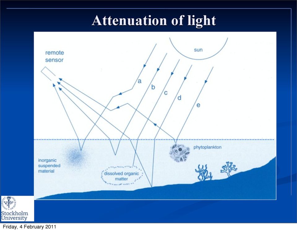
5 Attenuation of light 90% of signal from the atmosphere Figure: IOCCG Report Number 3 (2000)

6 Attenuation of light
7 Attenuation of light Case-1 water

8 Attenuation of light Case-2 Case-1 water
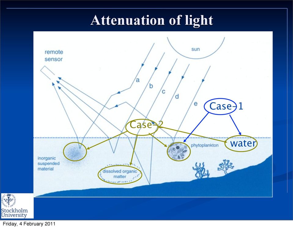
9 Attenuation of light Case-2 Case-1 water Classification: Morel and Prieur, 1977

10 Light penetration in the open sea and in coastal waters Oceanic Optical Case-1 waters Coastal Optical Case-2 waters Kurt Holacher, 2002

11 A multi-scale approach to monitoring Satellite remote sensing Optical monitoring Seatruthing Atmospheric corrections Large scale synoptic information Small and meso scale information Coastal Zone monitoring: Ecological and physiological variables Physics and chemistry Optical biogeochemical variables: CDOM, Chlorophyll, SPM Platforms: Research and monitoring vessels, moorings, ships-of-opportunity Decision-making Environmental policies and management Socio-economics (e.g. tourism and fisheries) (from Kratzer et al., 2003)
 (from Kratzer et al.")
12 Approach Use remote sensing to map water quality in the coastal zone Use optical indicators as diagnostic tool for management (Secchi depth, Kd490 and chlorophyll as indicators of eutrophication Use bio-optics as a link between remote sensing and ecology

13 Area of investigation: Himmerfjärden STP outlet Landsort Deep

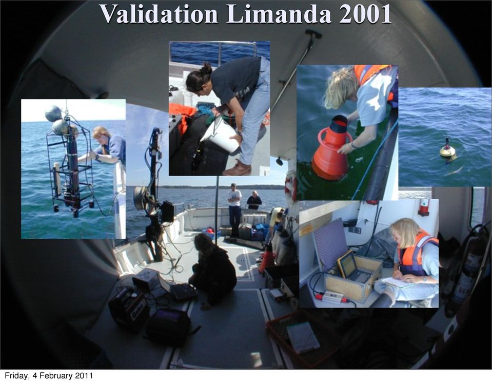
14 Validation Limanda
15 NASA Aeronet-OC Station at Gustaf Dalén light house

16 Optical variables: indicators of ecosystem state

17 Optical variables: indicators of ecosystem state CDOM: terrestrial inputs of freshwater

18 Optical variables: indicators of ecosystem state CDOM: terrestrial inputs of freshwater inorganic suspended particulate matter (SPM): land drainage and to wind-stirring in shallow waters,

19 Optical variables: indicators of ecosystem state CDOM: terrestrial inputs of freshwater inorganic suspended particulate matter (SPM): land drainage and to wind-stirring in shallow waters, and phytoplankton: productive status of the pelagic ecosystem; anthropogenic nutrients from land.

20 Polynomial decay from source to sink Himmerfjärden Open Sea Contribution of each optical component to K d (490) assuming a polynomial decline of optical components in relation to the source (land), Kratzer and Tett, 2009.
, Kratzer and Tett, 2009.")
21 TACCS radiometer
22 Optical monitoring of water quality
23 Optical monitoring of water quality
24 Optical monitoring of water quality K d (490) is a standard product of ocean colour sensors (SeaWiFS and MODIS)
25 Optical monitoring of water quality K d (490) is a standard product of ocean colour sensors (SeaWiFS and MODIS) K d (490) has been the most accurate and a reliable remote sensing product for the Baltic Sea.
26 Optical monitoring of water quality K d (490) is a standard product of ocean colour sensors (SeaWiFS and MODIS) K d (490) has been the most accurate and a reliable remote sensing product for the Baltic Sea. K d (490) has been the best link between optical in-water measurements and remote sensing data.
27 1/SD, m-1 Inverted Secchi Depth (SD) and K d (490) 0.6 y = x R² = Askö Kd(490) Kratzer et al., 2003
28 SeaWiFS image SeaWiFS Kd(490) image In-water algorithm: SD = (0.55 * K d (490) 0.04) -1 meters Secchi Depth (SD) map of the Baltic Sea (last week of July/beginning of August 1999, Kratzer et al., 2003)
29 MERIS improved monitoring of coastal waters
30 MERIS improved monitoring of coastal waters MERIS: improved spatial resolution over coastal areas (300 m resolution 1.2 km in open sea).
31 MERIS improved monitoring of coastal waters MERIS: improved spatial resolution over coastal areas (300 m resolution 1.2 km in open sea). Improved spectral resolution (more bands that are also more narrow; more optical substances can be derived).
32 Spatial resolution- example Wadden Sea MERIS, , 10:33 UTC FR, 300 m resolution Landsat 5, , 10:19 UTC 30 m resolution Borkum RR, 1.2 km resolution Ems Images courtesy of Carsten Brockmann
33 MERIS image 19 Aug 2002 RR HFV H5 HFV H4 H5 H3 H4 H3 FR H2 B1 H2 FR (300 m resolution) B1 RR (1.2 km resolution)
34 H5 H4 H3 H2 22 August, 2002, Kratzer et al., 2008
35 New K d 490 algorithm derived from sea-truthing data Kratzer et al, 2008
36 Secchi depth map ln(secchi depth) derived from MERIS data to test model output
37 Match-ups NW Baltic Sea July 2008 Sampling stations and transects during Askö field campaign 2008 (see PINS on each RR scene). The conditions were very good for sea-truthing. The MERIS RR RGB composites show how patchy the waters become during good conditions in summer. Kratzer & Vinterhav, 2010
38 Improvement of MERIS processors
39 Improvement of MERIS processors (*100) operational system
40 Test of BPAC Outputs (ICOL Processed) Moore et al. 2010
41 Aerosol Properties In-Situ α=1.87+/-0.02 BPAC α=1.71+/-0.09 Moore et al. 2010
42 TSM Scaled bb p Sta TSM BPA % C C C Moore et al. 2010
43 Chl Scaled a p (665) Sta Chl BP % C C C C Moore et al. 2010
44 Participation in COASTCOLOUR algorithm Round Robin global intercomparison of coastal algorithms
45 Applications Cyanobacteria Bloom in the Baltic Sea, MERIS full resolution (300 m), 13 July ESA
46 Operational system from research to applications
47 Interactive maps based on ArcGIS tool for data delivery and administration simple user interface and GIS functionality only web access necessary for the end-user! Server Zoom Measure Inquire Print Scale etc.
48 Suspended matter map in Himmerfjärden 31 July
49 Map of humic substances in Himmerfjärden 31 July 2008
50 Therese Arredal Harvey, PhD student
51 Therese Arredal Harvey, PhD student
52 Therese Arredal Harvey, PhD student
53 Therese Arredal Harvey, PhD student
54 Therese Arredal Harvey, PhD student
55 Temporal resolution Himmerfjärden, 2008 Measurements between April and September MERIS passes by every 2-3 day Regular cruises by monitoring vessels: 17 Remote sensing by MERIS: 20 Total set of chlorophyll a measurements: 37 Therese Arredal Harvey, PhD student
56 How representative is the satellite-derived chlorophyll a product? In costal areas Chlorophyll a concentrations are overestimated by 91 %. In open Sea the Chlorophyll a concentrations are overestimated by 25 %. (Kratzer and Vinterhav, 2010) Correct for this in the chl-a estimates
57 Therese Arredal Harvey, PhD student
58 Summary MERIS provides us with a new tool to assess coastal systems from space Indicators for eutrophication, e.g. chl-a and Secchi depth, can be derived from space Remote sensing data provides improve spatial and temporal resolution Chl-a concentrations from remote sensing not significantly different from conventional monitoring data Together with Vattenfall Power Consultant we have developed a user-friendly operational system
59 Outlook Continuation of operational system by joining GMES MarCoast downstream services for (BC-VPC- SU) Aim: continuous system update with best processor available (more funding is required) Stockholm University is champion users of the COASTCOLOUR project Validation of coast colour algorithm in the Baltic Sea Continuation of MERIS mission through Sentinel-3 (ocean colour sensor OLCI and SST / (A)ATSR) through 2023
60 Elements for Ecological Status in the EC Water Framework Directive (WFD): Biological elements: Phytoplankton, aquatic flora, benthic invertebrate fauna, fish fauna Hydro-morphological elements (supporting the biological elements): Morphological conditions, Hydrological and Tidal regime Chemical and physicochemical elements (supporting the biological elements): General: dissolved oxygen, nutrients, transparency, temperature; Specific: synthetic and non-synthetic pollutants Chl-a and Secchi depth are indicators for eutrophication
61 Elements for Ecological Status in the EC Water Framework Directive (WFD): Biological elements: Phytoplankton, aquatic flora, benthic invertebrate fauna, fish fauna Hydro-morphological elements (supporting the biological elements): Morphological conditions, Hydrological and Tidal regime Chemical and physicochemical elements (supporting the biological elements): General: dissolved oxygen, nutrients, transparency, temperature; Specific: synthetic and non-synthetic pollutants Chl-a and Secchi depth are indicators for eutrophication
62 Elements for Ecological Status in the EC Water Framework Directive (WFD): Biological elements: Phytoplankton, aquatic flora, benthic invertebrate fauna, fish fauna Hydro-morphological elements (supporting the biological elements): Morphological conditions, Hydrological and Tidal regime Chemical and physicochemical elements (supporting the biological elements): General: dissolved oxygen, nutrients, transparency, temperature; Specific: synthetic and non-synthetic pollutants Chl-a and Secchi depth are indicators for eutrophication
63 Elements for Ecological Status in the EC Water Framework Directive (WFD): Biological elements: Phytoplankton, aquatic flora, benthic invertebrate fauna, fish fauna Hydro-morphological elements (supporting the biological elements): Morphological conditions, Hydrological and Tidal regime Chemical and physicochemical elements (supporting the biological elements): General: dissolved oxygen, nutrients, transparency, temperature; Specific: synthetic and non-synthetic pollutants Chl-a and Secchi depth are indicators for eutrophication
64 Elements for Ecological Status in the EC Water Framework Directive (WFD): Biological elements: Phytoplankton, aquatic flora, benthic invertebrate fauna, fish fauna Hydro-morphological elements (supporting the biological elements): Morphological conditions, Hydrological and Tidal regime Chemical and physicochemical elements (supporting the biological elements): General: dissolved oxygen, nutrients, transparency, temperature; Specific: synthetic and non-synthetic pollutants Chl-a and Secchi depth are indicators for eutrophication
65 Elements for Ecological Status in the EC Water Framework Directive (WFD): Biological elements: Phytoplankton, aquatic flora, benthic invertebrate fauna, fish fauna Hydro-morphological elements (supporting the biological elements): Morphological conditions, Hydrological and Tidal regime Chemical and physicochemical elements (supporting the biological elements): General: dissolved oxygen, nutrients, transparency, temperature; Specific: synthetic and non-synthetic pollutants Chl-a and Secchi depth are indicators for eutrophication
66 Elements for Ecological Status in the EC Water Framework Directive (WFD): Biological elements: Phytoplankton, aquatic flora, benthic invertebrate fauna, fish fauna Hydro-morphological elements (supporting the biological elements): Morphological conditions, Hydrological and Tidal regime Chemical and physicochemical elements (supporting the biological elements): General: dissolved oxygen, nutrients, transparency, temperature; Specific: synthetic and non-synthetic pollutants Chl-a and Secchi depth are indicators for eutrophication
67 Elements for Ecological Status in the EC Water Framework Directive (WFD): Biological elements: Phytoplankton, aquatic flora, benthic invertebrate fauna, fish fauna Hydro-morphological elements (supporting the biological elements): Morphological conditions, Hydrological and Tidal regime Chemical and physicochemical elements (supporting the biological elements): General: dissolved oxygen, nutrients, transparency, temperature; Specific: synthetic and non-synthetic pollutants Chl-a and Secchi depth are indicators for eutrophication
68 SPICOSA project: use of Secchi depth as model link Nitrogen loading Total Nitrogen concentration Water exchange Nitrogen retention Secchi depth (water transparency) Secchi depth is estimated according to empirical relationship between nitrogen concentration and Secchi depth Courtesy: Jakob Walve ln(secchi depth) derived from satellite data to test model output
69
70 MVT intercalibration work-shop July 2008, Askö
71 Aeronet-OC Pålgrunden June 2009 (SENT-3 validation)
72 MVT Field inter-comparison at the Acqua Alta Oceanographic Tower (AAOT), Italy, July 19-22, 2010; lab calibration at JRC Above water systems In- water systems Water sampling In- water systems
73
74 Sea-truthing PhD training course, Askö, May 2010 Intercalibration with IOPAS (Poland)
75
76 Recent articles Kratzer, K. and Vinterhav, C., 2010, Improvement of MERIS data in Baltic Sea coastal areas by applying the Improved Contrast between Ocean and Land processor (ICOL), Oceanologia, 52 (2), Kratzer, S. and Tett, P., 2009, Using bio-optics to investigate the extent of coastal waters a Swedish case study, Hydrobiologia, 629: Kratzer, S., Brockmann, C. and Moore G., 2008, Using MERIS full resolution data (300 m spatial resolution) to monitor coastal waters a case study from Himmerfjärden, a fjord-like bay in the north-western Baltic Sea, Remote Sensing of Environment, 112(5), Pierson, D., Kratzer, S., Strömbeck, N., and Håkansson, B., 2008, Relationship between the attenuation of downwelling irradiance at 490 nm with the attenuation of PAR (400nm- 700nm) in the Baltic Sea, Remote Sensing of Environment, 112 (3),
77 Current aquatic remote sensing projects at SU Swedish National Space Board (SNSB): Using MERIS full resolution data for improved monitoring of coastal areas in the Baltic Sea from research to application, Focus: Fundamental research. ESA/ESRIN: Technical Assistance for the validation of MERIS products in lake Vänern and coastal waters of the north-western Baltic Sea (Sweden), mid mid Focus: Validation of MERIS data and intercalibration of radiometers. Participation in SPICOSA, and EU FP6 project on integrated coastal zone management: Focus: Academic training & developing remote sensing as diagnostic tool for integrated coastal zone management. Participation in Swedish Environmental Protection Agency (SEPA) project: Development of evaluation criteria for pelagic quality elements (Secchi depth) in coastal areas. Focus: Ecosystem monitoring and management. NordForsk: NORDic network for AQUAtic REMote Sensing ( nordaquarems.org/), Sept 2008-Sept 2011; coordinator: S.Kratzer. Focus: Networking, PhD training & curriculum development. WaterS: EU FP7 Marie Curie Industry-Academia Partnerships and Pathways (IAPP),
78
79
80 Thanks for listening! Any questions?
81 Thanks for listening! Any questions? SST bio-sensor, Kratzer Ltd. at Landsort Deep (BY31).
Monitoring Baltic Sea eutrophication from space- from research to applications
 Monitoring Baltic Sea eutrophication from space- from research to applications Susanne Kratzer, Associate Professor Coordinator of NordAquaRemS Department of Systems Ecology, SU Suse@ecology.su.se Marine
Update on EUMETSAT ocean colour services. Ewa J. Kwiatkowska
 Update on EUMETSAT ocean colour services Ewa J. Kwiatkowska 1 st International Ocean Colour Science meeting, 6 8 May, 2013 EUMETSAT space data provider for operational oceanography Operational data provider
Lake Monitoring in Wisconsin using Satellite Remote Sensing
 Lake Monitoring in Wisconsin using Satellite Remote Sensing D. Gurlin and S. Greb Wisconsin Department of Natural Resources 2015 Wisconsin Lakes Partnership Convention April 23 25, 2105 Holiday Inn Convention
DEVELOPMENT OF MERIS LAKE WATER ALGORITHMS: VALIDATION RESULTS FROM EUROPE
 DEVELOPMENT OF MERIS LAKE WATER ALGORITHMS: VALIDATION RESULTS FROM EUROPE Antonio Ruiz-Verdú (1) *, Sampsa Koponen (2), Thomas Heege (3), Roland Doerffer (4), Carsten Brockmann (5), Kari Kallio (6), Timo
Meris Reflectance and Algal-2 validation at the North Sea
 Meris Reflectance and Algal-2 validation at the North Sea Steef W.M. Peters IVM, De Boelelaan 187, 181 HV Amsterdam, Netherlands (steef.peters at ivm.vu.nl) Abstract In this paper spectral reflectances
How To Manage Water Resources
 NB: Unofficial translation; legally binding texts are those in Finnish and Swedish Ministry of the Environment, Finland Government Decree on Water Resources Management (1040/2006) Given in Helsinki on
BIOLOGICAL MONITORING WITH THE WESTERN CANADIAN ODAS MARINE BUOY NETWORK
 BIOLOGICAL MONITORING WITH THE WESTERN CANADIAN ODAS MARINE BUOY NETWORK Jim Gower, Angelica Peña and Ann Gargett Institute of Ocean Sciences, P.O. Box 6, Sidney, BC, V8L 4B2 Tel: 2 363-68, Fax: 363-6746,
COPERNICUS Coastal Service
 COPERNICUS Coastal Service The FP7 Space projects prospective A whitepaper List of Contributors Project FP7-AQUAMAR/ESA-GSE-MARCOAST FP7-OSS 2015 FP7--OSS 2015/FP7 AQUAMAR FP7-CoBiOS FP7 OSS2015 FP7 HIGHROC
The international Argo programme: a revolution for ocean and climate observations Pierre-Yves Le Traon*, Ifremer Coordinator NAOS Equipex Project
 The international Argo programme: a revolution for ocean and climate observations Pierre-Yves Le Traon*, Ifremer Coordinator NAOS Equipex Project * Acknowledgments: NAOS, French Argo, Euro-Argo/Argo international
Towards Operational Monitoring of the Baltic Sea by Remote Sensing
 G. Schernewski & N. Löser (eds.): Managing the Baltic Sea. Coastline Reports 2 (2004), ISSN 0928-2734 S. 211-218 Towards Operational Monitoring of the Baltic Sea by Remote Sensing Andreas Neumann 1, Harald
Present Status of Coastal Environmental Monitoring in Korean Waters. Using Remote Sensing Data
 Present Status of Coastal Environmental Monitoring in Korean Waters Using Remote Sensing Data Sang-Woo Kim, Young-Sang Suh National Fisheries Research & Development Institute #408-1, Shirang-ri, Gijang-up,
16 th IOCCG Committee annual meeting. Plymouth, UK 15 17 February 2011. mission: Present status and near future
 16 th IOCCG Committee annual meeting Plymouth, UK 15 17 February 2011 The Meteor 3M Mt satellite mission: Present status and near future plans MISSION AIMS Satellites of the series METEOR M M are purposed
Long-term Marine Monitoring in Willapa Bay. WA State Department of Ecology Marine Monitoring Program
 Long-term Marine Monitoring in Willapa Bay WA State Department of Ecology Marine Monitoring Program Ecology s Marine Waters Monitoring Program Goal: establish and maintain baseline environmental data Characterize
Integrating Environmental Optics into Multidisciplinary, Predictive Models of Ocean Dynamics
 DISTRIBUTION STATEMENT A. Approved for public release; distribution is unlimited. Integrating Environmental Optics into Multidisciplinary, Predictive Models of Ocean Dynamics John J. Cullen Department
LIMNOLOGY, WATER QUALITY
 LIMNOLOGY, WATER QUALITY PA RANI ET E R S, AN D c 0 IV D IT I 0 N S AND ECOREGIONS Water Quality Parameters Nutrients are important parameters because phosphorous and nitrogen are major nutrients required
Development of innovative tools for understanding marine biodiversity and assessing good environmental status: the progress of the EU project DEVOTES
 Development of innovative tools for understanding marine biodiversity and assessing good environmental status: the progress of the EU project DEVOTES Angel Borja Scientific Symposium 2015, 6-7 May, Malmö,
DISMAR: Data Integration System for Marine Pollution and Water Quality
 DISMAR: Data Integration System for Marine Pollution and Water Quality T. Hamre a,, S. Sandven a, É. Ó Tuama b a Nansen Environmental and Remote Sensing Center, Thormøhlensgate 47, N-5006 Bergen, Norway
ÂÂThe WISER kick-off meeting:
 July 29 WISER PROJECT NEWSLETTER The WISER kick-off meeting More than 1 scientists and water managers met during the kick-off meeting on Mallorca. The project s kick-off meeting took place from 9 to 13
Ocean Colour experience SeaWiFS / MODIS / VIIRS
 Ocean Colour experience SeaWiFS / MODIS / VIIRS Bryan Franz and the NASA Ocean Biology Processing Group presented by Ewa Kwiatkowska, EUMETSAT Sentinel-3 Cal/Val Meeting 20-22 March 2012 Goal Provide a
Chesapeake Bay and Potomac Tidal Monitoring Programs Past, Present and Future
 Chesapeake Bay and Potomac Tidal Monitoring Programs Past, Present and Future Bruce Michael Resource Assessment Service Maryland Department of Natural Resources The Future of Water Quality Monitoring in
Baltic Marine Environment Protection Commission
 Baltic Marine Environment Protection Commission Making the HELCOM eutrophication assessment operational (EUTRO-OPER) Helsinki, Finland, 3 September 2014 EUTRO-OPER 3-2014 Document title Outcome of the
Proba-V: Earthwatch Mission as part of ESA s Earth Observation Programmes
 Proba-V: Earthwatch Mission as part of ESA s Earth Observation Programmes Antwerp 05.07.2013 Bianca Hoersch Proba-V Mission Manager Third Party Mission & Sentinel-2 Mission Manager Earth Observation Directorate,
BIO-OPTICAL MODELING OF PRIMARY PRODUCTION FROM SEAWIFS OCEAN COLOR DATA FOR THE WESTERN ANTARCTIC PENINSULA REGION
 BIO-OPTICAL MODELING OF PRIMARY PRODUCTION FROM SEAWIFS OCEAN COLOR DATA FOR THE WESTERN ANTARCTIC PENINSULA REGION Raymond C. Smith ICESS, University of California, Santa Barbara, CA 93106 Karen S. Baker
SPOT4 (Take5) Contribution of Sentinel-2 to coast management
 Contribution of Sentinel-2 to coast management") SPOT4 (Take5) Contribution of Sentinel-2 to coast management Take 5 User s Day 2/10/2013 CNES Toulouse V. Lafon A. Robinet L. Barillé D. Bru S. Capo C. Cerisier A. Dehouck D. Doxaran D. Ducrot P. Gernez
SPOT4 (Take5) Contribution of Sentinel-2 to coast management Take 5 User s Day 2/10/2013 CNES Toulouse V. Lafon A. Robinet L. Barillé D. Bru S. Capo C. Cerisier A. Dehouck D. Doxaran D. Ducrot P. Gernez
ESA Climate Change Initiative contributing to the Global Space-based Architecture for Climate Monitoring
 ESA Climate Change Initiative contributing to the Global Space-based Architecture for Climate Monitoring Pascal Lecomte Head of the ESA Climate Office ESA/ECSAT Global Space-based Architecture for Climate
II. Related Activities
 (1) Global Cloud Resolving Model Simulations toward Numerical Weather Forecasting in the Tropics (FY2005-2010) (2) Scale Interaction and Large-Scale Variation of the Ocean Circulation (FY2006-2011) (3)
Appendix B: Cost Estimates
 Appendix B: Estimates This appendix presents the estimated costs of the monitoring and supplemental research components presented in Section 3 of this document. A 20% quality assurance and quality control
4 Decades of Belgian Marine Monitoring. presented by Karien De Cauwer, RBINS, Belgian Marine Data Centre
 4 Decades of Belgian Marine Monitoring presented by Karien De Cauwer, RBINS, Belgian Marine Data Centre 47 th International Liege colloquium, Liège, 4-8 th May 2015 Uplifting historical data to today s
Aquatic Biomes, Continued
 Aquatic Biomes, Continued Introduction Extent of Marine biomes Issues & challenges Factors influencing distribution Dynamics in time & space Depth Tour of marine biomes Issues (by biome) Freshwater biomes
The European Space Agency s Synthetic Aperture Radar Programme From Experiment to Service Provision
 The European Space Agency s Synthetic Aperture Radar Programme From Experiment to Service Provision Evert Attema ESA, Directorate of Earth Observation Programme! The idea of an independent European space
MEPC 56/23 ANNEX 2 Page 1 ANNEX 2 RESOLUTION MEPC.162(56) Adopted on 13 July 2007
 Adopted on 13 July 2007") Page 1 RESOLUTION MEPC.162(56) Adopted on 13 July 2007 GUIDELINES FOR RISK ASSESSMENT UNDER REGULATION A-4 OF THE BWM CONVENTION (G7) THE MARINE ENVIRONMENT PROTECTION COMMITTEE, RECALLING Article 38(a)
Page 1 RESOLUTION MEPC.162(56) Adopted on 13 July 2007 GUIDELINES FOR RISK ASSESSMENT UNDER REGULATION A-4 OF THE BWM CONVENTION (G7) THE MARINE ENVIRONMENT PROTECTION COMMITTEE, RECALLING Article 38(a)
Guidance on establishing reference conditions and ecological status class boundaries for inland surface waters
 CIS - WFD Guidance on establishing reference conditions and ecological status class boundaries for inland surface waters Produced by Working Group 2.3 1 Reference conditions for inland surface waters (REFCOND)
Ocean Level-3 Standard Mapped Image Products June 4, 2010
 Ocean Level-3 Standard Mapped Image Products June 4, 2010 1.0 Introduction This document describes the specifications of Ocean Level-3 standard mapped archive products that are produced and distributed
2.4HOL6 FINAL DRAFT GUIDANCE ON TYPOLOGY, REFERENCE CONDITIONS AND CLASSIFICATION SYSTEMS FOR TRANSITIONAL AND COASTAL WATERS
 GUIDANCE ON TYPOLOGY, REFERENCE CONDITIONS AND CLASSIFICATION SYSTEMS FOR TRANSITIONAL AND COASTAL WATERS PRODUCED BY CIS WORKING GROUP 2.4 (COAST) Status Box Status: final draft for presentation at the
Remote sensing and GIS applications in coastal zone monitoring
 Remote sensing and GIS applications in coastal zone monitoring T. Alexandridis, C. Topaloglou, S. Monachou, G.Tsakoumis, A. Dimitrakos, D. Stavridou Lab of Remote Sensing and GIS School of Agriculture
Temporal characterization of the diffuse attenuation coefficient in Abrolhos Coral Reef Bank, Brazil
 Temporal characterization of the diffuse attenuation coefficient in Abrolhos Coral Reef Bank, Brazil Maria Laura Zoffoli 1, Milton Kampel 1, Robert Frouin 2 1 Remote Sensing Division (DSR) National Institute
Eutrophication Monitoring Guidelines by Remote Sensing for the NOWPAP Region
 NOWPAP CEARAC Northwest Pacific Action Plan Special Monitoring and Coastal Environmental Assessment Regional Activity Centre 5-5 Ushijimashin-machi, Toyama City, Toyama 930-0856, Japan Tel: +81-76-445-1571,
PARTNER PROFILE. If you are interested to join the partnership for the upcoming EU calls for proposals please fill in the following questions:
 PARTNER PROFILE If you are interested to join the partnership for the upcoming EU calls for proposals please fill in the following questions: Organisation (name, address, department, contact person, tel.,
SATELLITE OCEANOGRAPHY IN THE AZORES: PAST, PRESENT AND FUTURE
 SATELLITE OCEANOGRAPHY IN THE AZORES: PAST, PRESENT AND FUTURE Oceanography Section / DOP University of the Azores Ana Martins Email: anamartins@uac.pt Azores (NE Atlantic) - very exposed to harsh environments
Hydrographic Surveying using High Resolution Satellite Images
 Hydrographic Surveying using High Resolution Satellite Images Petra PHILIPSON and Frida ANDERSSON, Sweden Key words: remote sensing, high resolution, hydrographic survey, depth estimation. SUMMARY The
Annex VIII. Development of the portal site on remote sensing. (Reviewed by the Second Meeting of NOWPAP WG4)
") Page 1 Development of the portal site on remote sensing (Reviewed by the Second Meeting of NOWPAP WG4) Page 1 Development of the portal site on remote sensing 1 Background Based on the consideration in
Page 1 Development of the portal site on remote sensing (Reviewed by the Second Meeting of NOWPAP WG4) Page 1 Development of the portal site on remote sensing 1 Background Based on the consideration in
Pond Ecosystem Field Study MOLS
 This multi-week lab involves field studies comparing ecosystem-level ecology between 2 freshwater ponds in Marshfield Outdoor Learning Sanctuary. We will be investigating a correlation between weather
NASA Earth System Science: Structure and data centers
 SUPPLEMENT MATERIALS NASA Earth System Science: Structure and data centers NASA http://nasa.gov/ NASA Mission Directorates Aeronautics Research Exploration Systems Science http://nasascience.nasa.gov/
RECALLING Paragraph b of Article 13 of the Convention on the Protection of the Marine Environment of the Baltic Sea Area, 1974 (Helsinki Convention),
,") CONVENTION ON THE PROTECTION OF THE MARINE ENVIRONMENT OF THE BALTIC SEA AREA HELSINKI COMMISSION - Baltic Marine HELCOM 19/98 Environment Protection Commission 15/1 Annex 3 19th Meeting Helsinki, 23-27
CONVENTION ON THE PROTECTION OF THE MARINE ENVIRONMENT OF THE BALTIC SEA AREA HELSINKI COMMISSION - Baltic Marine HELCOM 19/98 Environment Protection Commission 15/1 Annex 3 19th Meeting Helsinki, 23-27
Satellite'&'NASA'Data'Intro'
 Satellite'&'NASA'Data'Intro' Research'vs.'Opera8ons' NASA':'Research'satellites' ' ' NOAA/DoD:'Opera8onal'Satellites' NOAA'Polar'Program:'NOAA>16,17,18,19,NPP' Geosta8onary:'GOES>east,'GOES>West' DMSP'series:'SSM/I,'SSMIS'
Introduction to protection goals, ecosystem services and roles of risk management and risk assessment. Lorraine Maltby
 Introduction to protection goals, ecosystem services and roles of risk management and risk assessment. Lorraine Maltby Problem formulation Risk assessment Risk management Robust and efficient environmental
The MERis MAtchup In situ Database: MERMAID
 The MERis MAtchup In situ Database: MERMAID Kathryn Barker 1, Constant Mazeran 2, Christophe Lerebourg 2, Marc Bouvet 3, David Antoine 4, Michael Ondrusek 5, Guiseppe Zibordi 6, Samantha Lavender 1 With
Automated In-Situ Water Quality Monitoring Report
 Automated In-Situ Water Quality Monitoring Report Issued by the North of Ireland Joint Agency Coastal Monitoring Programme. For further information and data access please visit our website at: www.afbini.gov.uk/coastal-monitoring.htm
UK ENVIRONMENTAL STANDARDS AND CONDITIONS (PHASE 1) Final report. April 2008
 Final report. April 2008") UK Technical Advisory Group on the Water Framework Directive UK ENVIRONMENTAL STANDARDS AND CONDITIONS (PHASE 1) Final report April 2008 (SR1 2006) Final Table of Contents LIST OF TABLES...3 SECTION 1
UK Technical Advisory Group on the Water Framework Directive UK ENVIRONMENTAL STANDARDS AND CONDITIONS (PHASE 1) Final report April 2008 (SR1 2006) Final Table of Contents LIST OF TABLES...3 SECTION 1
Satellite Snow Monitoring Activities Project CRYOLAND
 Satellite Snow Monitoring Activities Project CRYOLAND Background material for participants to the Workshop on European Snow Monitoring Perspectives, Darmstadt, 4-5 December 2012. CryoLand provides Snow,
Sources to Seafood: Mercury Pollution in the Marine Environment Background on Presenting Scientists
 Celia Y. Chen, Ph.D Dartmouth College Research Professor Department of Biological Sciences Class of '78 Life Sciences Center HB 6044 Hanover, NH 03755 (603)646 2376 Celia.chen@dartmouth.edu Dr. Celia Chen
Chapter 3 Communities, Biomes, and Ecosystems
 Communities, Biomes, and Ecosystems Section 1: Community Ecology Section 2: Terrestrial Biomes Section 3: Aquatic Ecosystems Click on a lesson name to select. 3.1 Community Ecology Communities A biological
Integrating Near Real-Time Data for Coral Reef Ecosystem Forecasting
 Integrating Near Real-Time Data for Coral Reef Ecosystem Forecasting NOAA s Integrated Coral Observing Network (ICON) Atlantic Oceanographic and Meteorological Laboratory Laboratory Review, March 18, 2008
@race4thebaltic #RFTBBCGReport. Barbara Jackson Programme Director Zennström Philanthropies
 @race4thebaltic #RFTBBCGReport Barbara Jackson Programme Director Zennström Philanthropies Background This report was commissioned by Zennström Philanthropies to better understand local benefits from
Report EU BASIN Kickoff Meeting, Copenhagen, Denmark
 Report EU BASIN Kickoff Meeting, Copenhagen, Denmark February 22 25, 2011, Meng Zhou Table of Contents Summary... 1 1. Highlights... 2 1) EU BASIN cruises... 2 2) Regional comparative studies and end to
IMAGINES_VALIDATIONSITESNETWORK ISSUE 1.00. EC Proposal Reference N FP7-311766. Name of lead partner for this deliverable: EOLAB
 Date Issued: 26.03.2014 Issue: I1.00 IMPLEMENTING MULTI-SCALE AGRICULTURAL INDICATORS EXPLOITING SENTINELS RECOMMENDATIONS FOR SETTING-UP A NETWORK OF SITES FOR THE VALIDATION OF COPERNICUS GLOBAL LAND
First WISER deliverables available
 December 2009 WISER PROJECT NEWSLETTER 02 First WISER deliverables available Deliverable D3.2-1 Overview and comparison of macrophyte survey methods used in European countries and a proposal for a harmonised
Project VISLA; coupling environmental and remote sensing research for better understanding of coastal waters ecosystems and its sustainable management
 Project ; coupling environmental and remote sensing research for better understanding of coastal waters ecosystems and its sustainable management Beneficiary: University of Warmia and Mazury in Olsztyn
Courtesy of José Aguilar-Manjarrez
 Fish ponds for culture of Nile tilapia, African catfish and African bonytongue, Cameroon There is considerable potential to expand inland aquaculture in Africa to improve food security. To aid aquaculture
Department of Environmental Engineering
 Department of Environmental Engineering Master of Engineering Program in Environmental Engineering (International Program) M.Eng. (Environmental Engineering) Plan A Option 1: (1) Major courses: minimum
SLSTR Breakout Summary - Gary Corlett (22/03/2012)
") SLSTR Breakout Summary - Gary Corlett (22/03/2012) [Updated 16/04/2012 with post meeting comments from Gorm Dybkjær, Simon hook and David Meldrum] The breakout session started with a clean slate and identified
SLSTR Breakout Summary - Gary Corlett (22/03/2012) [Updated 16/04/2012 with post meeting comments from Gorm Dybkjær, Simon hook and David Meldrum] The breakout session started with a clean slate and identified
The NASA NEESPI Data Portal to Support Studies of Climate and Environmental Changes in Non-boreal Europe
 The NASA NEESPI Data Portal to Support Studies of Climate and Environmental Changes in Non-boreal Europe Suhung Shen NASA Goddard Space Flight Center/George Mason University Gregory Leptoukh, Tatiana Loboda,
PETROBRAS Orbital Sea Surface Monitoring
 PETROBRAS Orbital Sea Surface Monitoring Performed by : Contingency Control - Exploration & Production Area Technical support: R&D Center Cristina Bentz PETROBRAS R&D Center Environment Assessment and
Phosphorus and Sulfur
 Global Change Instruction Program Phosphorus and Sulfur The Important Nutrient Phosphorus Phosphorus is a key nutrient, fueling organic productivity on land and in water. A portion of its cycle is shown
BIODIVERSITY-RELATED REQUIREMENTS OF THE MARINE STRATEGY FRAMEWORK DIRECTIVE
 Biodiversity-related requirements of the Marine Strategy Framework Directive 1 VIVI FLEMING-LEHTINEN BIODIVERSITY-RELATED REQUIREMENTS OF THE MARINE STRATEGY FRAMEWORK DIRECTIVE IN SYNERGY WITH THE HABITATS
Atmospheric correction of SeaWiFS imagery for turbid coastal and inland waters
 Atmospheric correction of SeaWiFS imagery for turbid coastal and inland waters Kevin George Ruddick, Fabrice Ovidio, and Machteld Rijkeboer The standard SeaWiFS atmospheric correction algorithm, designed
Remote Sensing Applied in Marine Fishing: A Review on Indian Marine Fishing Industry Context
 International Journal of Computer Sciences and Engineering Open Access Review Paper Volume-4, Special Issue-1 E-ISSN: 2347-2693 Remote Sensing Applied in Marine Fishing: A Review on Indian Marine Fishing
Water Quality Modeling in Delaware s Inland Bays: Where Have We Been and Where Should We Go?
 Water Quality Modeling in Delaware s Inland Bays: Where Have We Been and Where Should We Go? Damian C. Brady University of Maine Center for the Inland Bays Science and Technical Advisory Committee March
INVESTIGA I+D+i 2013/2014
 INVESTIGA I+D+i 2013/2014 SPECIFIC GUIDELINES ON AEROSPACE OBSERVATION OF EARTH Text by D. Eduardo de Miguel October, 2013 Introducction Earth observation is the use of remote sensing techniques to better
SWEDISH METEOROLOGICAL AND HYDROLOGICAL INSTITUTE
 2010 SWEDISH METEOROLOGICAL AND HYDROLOGICAL INSTITUTE DIRECTOR GENERAL s OUTLOOK BUSINESS & MEDIA SERVICES HUMAN RESOURCES RESEARCH SMHI s mandate is to produce decision support to promote good planning,
The use of Earth Observation technology to support the implementation of the Ramsar Convention
 Wetlands: water, life, and culture 8th Meeting of the Conference of the Contracting Parties to the Convention on Wetlands (Ramsar, Iran, 1971) Valencia, Spain, 18-26 November 2002 COP8 DOC. 35 Information
What types of monitoring do we do? Freshwater (rivers, streams) Marine Waters (bays, ocean) & Tidal Rivers Ambient Ground Water
 Marine Waters (bays, ocean) & Tidal Rivers Ambient Ground Water") What types of monitoring do we do? Freshwater (rivers, streams) Marine Waters (bays, ocean) & Tidal Rivers Ambient Ground Water What do we monitor these waters for? Sanitary Quality (indicators of human
What types of monitoring do we do? Freshwater (rivers, streams) Marine Waters (bays, ocean) & Tidal Rivers Ambient Ground Water What do we monitor these waters for? Sanitary Quality (indicators of human
CORAL REEF HABITAT MAPPING USING MERIS: CAN MERIS DETECT CORAL BLEACHING?
 CORAL REEF HABITAT MAPPING USING MERIS: CAN MERIS DETECT CORAL BLEACHING? Arnold G. Dekker, Magnus Wettle, Vittorio E. Brando CSIRO Land & Water, P.O. Box 1666, Canberra, ACT, Australia ABSTRACT/RESUME
 Preface The term algal bloom is used to describe the temporal and spatial accumulation of phytoplankton in general or a single species in an aquatic environment. The phenomenon of water discoloration produced
ESTUARY RESEARCH PROJECT HIGHLIGHTS ADVANTAGES OF CONTINUOUS MONITORING IN CHRISTCHURCH HARBOUR
 Imagery TerraMetrics, Map data 2015 Google ESTUARY RESEARCH PROJECT HIGHLIGHTS ADVANTAGES OF CONTINUOUS MONITORING IN CHRISTCHURCH HARBOUR EXO2 SONDES AND STORM 3 DATA LOGGER Application Note XAUK OC201-01
A Model to Help You Determine Your
 A User-Friendly Model for Predicting Greenhouse Gas Fluxes and Carbon Sequestration Wetland s Carbon in Tidal Budget Wetlands A Model to Help You Determine Your Omar Abdul-Aziz, Ph.D., Assistant Professor
Approaches to biogeographic classification of the world s oceans. Marjo Vierros United Nations University Institute of Advanced Studies
 Approaches to biogeographic classification of the world s oceans Marjo Vierros United Nations University Institute of Advanced Studies This presentation will cover International policy developments of
SPATIAL VARIATION IN THE BIOCHEMICAL COMPOSITION OF SACCHARINA LATISSIMA
 SPATIAL VARIATION IN THE BIOCHEMICAL COMPOSITION OF SACCHARINA LATISSIMA Bruhn A, Nielsen MM, Manns D, Rasmussen MB, Petersen JK & Krause-Jensen D 4 TH NORDIC ALGAE CONFERENCE GRENÅ 2014 BIOCHEMICAL VARIATION
8.3.18 Advice May 2014
 8.3.18 Advice May 2014 ECOREGION STOCK Baltic Sea Sprat in Subdivisions 22 32 (Baltic Sea) Advice for 2015 ICES advises on the basis of the MSY approach that catches in 2015 should be no more than 222
How To Assess The Vulnerability Of The Neman River To Climate Change
 Management of the Neman River basin with account of adaptation to climate change Progress of the pilot project since February, 2011 Vladimir Korneev, Central Research Institute for Complex Use of Water
Global environmental information Examples of EIS Data sets and applications
 METIER Graduate Training Course n 2 Montpellier - february 2007 Information Management in Environmental Sciences Global environmental information Examples of EIS Data sets and applications Global datasets
INVESTIGATION OF TOTAL SUSPENDED MATTER IN PORONG REGION USING AQUA-MODIS SATELLITE DATA AND NUMERICAL MODEL. e-mail : Bambang_sukresno@yahoo.
 INVESTIGATION OF TOTAL SUSPENDED MATTER IN PORONG REGION USING AQUA-MODIS SATELLITE DATA AND NUMERICAL MODEL Bambang Sukresno* 1, Bayu Priyono 2, Dedy Aan Zahrudin 3, Berny A Subki 4 1 Institute for Marine
Origins and causes of river basin sediment degradation and available remediation and mitigation options. Feedback from the Riskbase workshop
 Origins and causes of river basin sediment degradation and available remediation and mitigation options Feedback from the Riskbase workshop Corinne Merly 1, Olivier Cerdan 1, Laurence Gourcy 1 Emmanuelle
Florida Institute of Oceanography
 Florida Institute of Oceanography Dr. William T. Hogarth, Interim Director, FIO & Dr. Jyotika I. Virmani, Associate Director, FIO National Water Quality Monitoring Council New Orleans, LA May 3-5, 2011
Introduction to teledection
 Introduction to teledection Formation Sébastien Clerc, ACRI-ST sebastien.clerc@acri-st.fr ACRI-ST Earth Observation Actors and Markets 2 Earth Observation economic importance Earth Observation is one of
Resolutions of Remote Sensing
 Resolutions of Remote Sensing 1. Spatial (what area and how detailed) 2. Spectral (what colors bands) 3. Temporal (time of day/season/year) 4. Radiometric (color depth) Spatial Resolution describes how
MONITORING BLUE-GREEN ALGAE IN THE IJSSELMEER USING REMOTE SENSING AND IN-SITU MEASUREMENTS
 MONITORING BLUE-GREEN ALGAE IN THE IJSSELMEER USING REMOTE SENSING AND IN-SITU MEASUREMENTS MARY CHAWIRA February, 2012 SUPERVISORS: Dr. Ir. Mhd. Suhyb Salama Dr. Ir Rogier van der Velde MONITORING BLUE-GREEN
Marine Biology with PADI Diving Certification
 Marine Biology with PADI Diving Certification A High School Summer Program Copyright 2011 Jeffrey S. Sanow, Sinbad Scuba Ltd Executive Summary The Marine Biology with PADI Diving Certification is a proven
Schools on Board Lab/Fieldwork Activity Example (As it appears in the Student Handbook!)
") Schools on Board Lab/Fieldwork Activity Example (As it appears in the Student Handbook!) Tracking down phytoplankton biomass in the water column HYPOTHESIS DRIVEN LAB ACTIVITY Lab Created by: Karine Lacoste
Schools on Board Lab/Fieldwork Activity Example (As it appears in the Student Handbook!) Tracking down phytoplankton biomass in the water column HYPOTHESIS DRIVEN LAB ACTIVITY Lab Created by: Karine Lacoste
Sediment and Dredged Material Management - Relevance and Objectives 18 September 2003
 - Relevance and Objectives 1. Scope of the Dutch German Exchange (DGE) The Netherlands and Germany have large river systems such as Danube, Rhine, Meuse, Elbe, Weser and Ems, which have important hydrological
Slide 1. Slide 2. Slide 3
 Satellite Analysis of Sea Surface Temperatures in the Florida Keys to Monitor Coral Reef Health NASA Stennis Space Center Earthzine/DEVELOP Virtual Poster Session, Summer 2011 Video Transcript Slide 1
Unveiling the disaster. A satellite based habitat impact assessment of the Deepwater Horizon Oil Spill
 Unveiling the disaster A satellite based habitat impact assessment of the Deepwater Horizon Oil Spill Gulf of Mexico Background of the disaster The Gulf oil spill situation has evolved, and so have the
Ireland. Water Framework Directive Monitoring Programme
 Ireland Water Framework Directive Monitoring Programme Prepared to meet the requirements of the EU Water Framework Directive (2000/60/EC) and National Regulations implementing the Water Framework Directive
Guidance Document for Sediment Assessment
 Guidance Document for Sediment Assessment Methods to determine to what extent the realization of water quality objectives of a water system is impeded by contaminated sediments Date 4 November 2010 Status
Smithsonian Environmental Research Center, P. O. Box 28, Edgewater, Maryland 20137
 Estuaries Vol. 24, No. 3, p. 381 397 June 2001 Calculating Optical Water Quality Targets to Restore and Protect Submersed Aquatic Vegetation: Overcoming Problems in Partitioning the Diffuse Attenuation
BOUSSOLE Monthly Cruise Report
 The BOUSSOLE project technical reports; report # 10-3, issue 1. BOUSSOLE Monthly Cruise Report Cruise 20 March 15 17, 2003 Duty Chief: Alec Scott (alec.scott@obs-vlfr.fr) Vessel: R/V Téthys II (Captain:
Does satellite observation of chlorophyll-a and suspended sediment complement Rijkswaterstaat monitoring of the North Sea?
 Ministerie van Verkeer en Waterstaat opq Does satellite observation of chlorophyll-a and suspended sediment complement Rijkswaterstaat monitoring of the North Sea? 53515 AGI ToRSMoN AGI-2007-GPMP-017 2
LAKEWATCH Report for Dead in Gulf County Using Data Downloaded 10/6/2015
 LAKEWATCH Report for Dead in Gulf County Introduction Lakes In 2012 Florida LAKEWATCH staff published the following three papers describing 1) how the location of lakes in different geologic areas (Figure
Environmental Sustainability: Academic resources, degrees, courses, research, and service
 Environmental Sustainability: Academic resources, degrees, courses, research, and service Library WSU Vancouver's library has more than 800 journals in hardcopy; over 9,000 fulltext online journals and
SCICEX boat-to-archive route map and data management template Biological and Chemical Samples
 SCICEX boat-to-archive route map and data management template Biological and Chemical Samples R. Sambrotto & B. Smethie SCICEX SAC Feb. 14-15, 2013 SCICEX data management can be thought of in four parts: