TRMM and Other Global Precipitation Products and Data Services at NASA GES DISC. Zhong Liu George Mason University and NASA GES DISC
|
|
|
- Joan Quinn
- 8 years ago
- Views:
Transcription
1 TRMM and Other Global Precipitation Products and Data Services at NASA GES DISC Zhong Liu George Mason University and NASA GES DISC

2 Outline Introduction of data and services at GES DISC TRMM and other precipitation products Precipitation data services Online Visualization and Analysis Tools (TOVAS) Precipitation application services Summary and URLs Hands on activity (if time allows)

3 Introduction GES DISC: NASA Goddard Earth Sciences (GES) Data and Information Services Center (DISC), located at Goddard Space Flight Center, in Greenbelt, Maryland. One of 12 NASA Science Mission Directorate (SMD) Data Centers that provide Earth science data, information, and services to research scientists, applications scientists, applications users, and students

4 Archives for: Precipitation (TRMM and others) Hydrology (North American Land Data Assimilation System (NLDAS) and Global Land Data Assimilation System (GLDAS) data products (both generated by GSFC's Hydrological Sciences Branch). Atmospheric composition Atmospheric dynamics (Modern Era Retrospective Analysis for Research and Applications (MERRA) data assimilation datasets (generated by GSFC s Global Modeling and Assimilation Office)

5 Summary of Projects and Data Products at GES DISC

6 Summary of Projects and Data Products at GES DISC (Cont )

7 TRMM and Other Precipitation Products

8 The Most Popular Products

9

10

11 How to order them?

12 Precipitation Data Services Mirador ( Simple Subset Wizard ( OPeNDAP ( GDS ( gds) Open Geospatial Consortium (OGC) Web Map Service (WMS) gc.shtml
 GDS (http://disc.sci.gsfc.nasa.")
13 Simple Subset Wizard

14
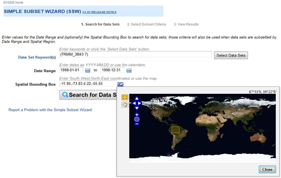
15

16 Online Visualization and Analysis Tools (TOVAS) TOVAS stands for TRMM Online Visualization and Analysis System Fast and easy to use No data download is needed Explore several popular TRMM standard products (3B42, 3B43, 3B42 daily, GPCP, etc.) Allow downloading result data in NetCDF, HDF, and ASCII

17 Products in TOVAS Near real time Rainfall Archives Ground Observation Archives Other Ancillary Products

18 Near real time (3/2000 present) 3 Hourly combined (3B42RT) 3 Hourly microwave (3B40RT) Hourly IR (3B41RT) Daily (derived from 3B42RT)
 Daily (derived from")
19 Rainfall Archives (1998 present) 3 Hourly (3B42) Daily (derived from 3B42) 10 day (derived from 3B42) Monthly (3B43, 3A12, 3A25, GPCP, etc.)

20 Ground Observation Archives Willmott ( , 0.5 deg) GPCC (1986 present, 1 deg)
 GPCC (1986")
21 Others: Monthly Global Precipitation (GPCP) Prototype Interactive Inter comparison of Rainfall Products Monthly Rainfall (3B43 V7) Anomaly Inter Comparison of 3 hourly, Daily, Monthly and Rainfall Climatology
22 TOVAS Landing Page
23 Sample of TOVAS GUI
24
25
26
27
28
29 TOVAS Functions and Examples
30 TOVAS Functions: Animation Lat-Lon Area Plot, Time-averaged Lat-Lon Plot, Difference Map Latitude-Time Hovmöller Plot Longitude-Time Hovmöller Plot Correlation Plot Comparison Plot Cross-Map Plot (Latitude-Height) Cross-Map Plot (Longitude-Height) Cross-Map Plot (Time-Height) Scatter Plot Scatter Plot, Time-averaged Time Series, Area-averaged Time Series Difference Time Series, Area Statistics
31 Other Features: Climatology Anomaly and normalized anomaly Fine tune graphic output Output in other formats (e.g., NetCDF) Google Earth KMZ file output Application examples with real events FAQ and documentation Help desk
32 2D Plots (The contribution of Isabel in 2003) Isabel
33 2D Lat Lon Plots (Record breaking rainfall in the Mid Atlantic Region in 2003)
34 Time Series Plots Floyd Alex, Charley, Gaston Isabel Mid Atlantic Region
35 Hovmoller Diagram (Mid Atlantic Region) Multiple Tropical Storms Isabel Floyd
36 Anomaly (Positive anomaly due to Isabel in Sept., 2003)
37
38
39 Other Ancillary Tools Hurricane Data Analysis Tool (HDAT) Other Giovanni Tools
40 Hurricane Data Analysis Tool: The global merged IR product, also known as, the NCEP/CPC 4km Global (60ºN 60ºS) IR Dataset, is one of TRMM ancillary datasets. 4 km IR Global (60ºN 60ºS) 30 minutes Since Feb., 2000
41 Basic Functions and Features: Selection of area of interest Single image or multiple images (animation) Allow time skipping (1 hr., 2 hr., etc.) Allow different image sizes False color Fine tune graphic output
42 HDAT Landing Page
43 HDAT Landing Page (Cont.):
44 HDAT Landing Page (Cont.):
45 HDAT Landing Page (Cont.):
46 Examples: Category 2cyclone Catarina Landfall
47 AF Flight 447: Satellite Observation of Mesoscale Convective System Development on 1 June, 2009
48
49 Other Giovanni Tools: Giovanni: GES DISC (Goddard Earth Sciences Data and Information Services Center) Interactive Online Visualization ANd analysis Infrastructure
50
51 Summary NASA global precipitation products (orbital, 3 hourly, daily, monthly) at your fingertips Data services available (Search, Subsetting, Format conversion, OPeNDAP, GDS, WMS, etc.) Online visualization and analysis system (TOVAS) to facilitate data exploration Online documentation and user support available
52 URLs: TOVAS: HDAT: Mirador: Giovanni: Current conditions: nt_conditions.shtml GES DISC: Contact:
53 Thank You!
54 Hands on Demo (if time allowed)
55
56
57
58
Data Products via TRMM Online Visualization and Analysis System
 Accessing Global Precipitation Data Products via TRMM Online Visualization and Analysis System (TOVAS) Zhong Liu Center for Spatial Information Science and Systems (CSISS), George Mason University and
Satellite Products and Dissemination: Visualization and Data Access
 Satellite Products and Dissemination: Visualization and Data Access Gregory Leptoukh GES DISC, NASA GSFC Dana Ostrenga GES DISC, NASA GSFC Introduction The Goddard Earth Sciences Data and Information Services
Giovanni: A System for Rapid Access, Visualization and Analysis of Earth Science Data Online
 Giovanni: A System for Rapid Access, Visualization and Analysis of Earth Science Data Online Suhung Shen *, H. Rui, Z. Liu, T Zhu, L. Lu, S. Berrick, G. Leptoukh, W. Teng, J. Acker, J. Johnson, S. P. Ahmad,
Asynchronous Data Mining Tools at the GES-DISC
 Asynchronous Data Mining Tools at the GES-DISC Long B. Pham, Stephen W. Berrick, Christopher S. Lynnes and Eunice K. Eng NASA Goddard Space Flight Center Distributed Active Archive Center Introduction
Satellite'&'NASA'Data'Intro'
 Satellite'&'NASA'Data'Intro' Research'vs.'Opera8ons' NASA':'Research'satellites' ' ' NOAA/DoD:'Opera8onal'Satellites' NOAA'Polar'Program:'NOAA>16,17,18,19,NPP' Geosta8onary:'GOES>east,'GOES>West' DMSP'series:'SSM/I,'SSMIS'
Tropical Rainfall Measuring Mission (TRMM) Precipitation Data and Services for
 Precipitation Data and Services for") 1 2 Tropical Rainfall Measuring Mission (TRMM) Precipitation Data and Services for Research and Applications 3 4 5 6 7 8 9 10 Zhong Liu 1, Dana Ostrenga 2, William Teng 3, and Steven Kempler NASA Goddard
1 2 Tropical Rainfall Measuring Mission (TRMM) Precipitation Data and Services for Research and Applications 3 4 5 6 7 8 9 10 Zhong Liu 1, Dana Ostrenga 2, William Teng 3, and Steven Kempler NASA Goddard
Web-based spatio-temporal visualization and analysis of the Siberian Earth System Science Cluster (SIB-ESS-C)
") Web-based spatio-temporal visualization and analysis of the Siberian Earth System Science Cluster (SIB-ESS-C) Roman Gerlach Supervisor: Prof. C. Schmullius (Dept. of Geography, Friedrich-Schiller-University
Web-based spatio-temporal visualization and analysis of the Siberian Earth System Science Cluster (SIB-ESS-C) Roman Gerlach Supervisor: Prof. C. Schmullius (Dept. of Geography, Friedrich-Schiller-University
CEOS Water Portal Status Update
 CEOS Water Portal Status Update Satoko Horiyama MIURA / Atsushi KAWAI JAXA/Mission Operations System Office WGISS-31 Introduction CEOS Water Portal is ; A web based portal system evolved from Distributed
The NASA NEESPI Data Portal to Support Studies of Climate and Environmental Changes in Non-boreal Europe
 The NASA NEESPI Data Portal to Support Studies of Climate and Environmental Changes in Non-boreal Europe Suhung Shen NASA Goddard Space Flight Center/George Mason University Gregory Leptoukh, Tatiana Loboda,
EXPLORING NASA AND ESA ATMOSPHERIC DATA USING GIOVANNI, THE ONLINE VISUALIZATION AND ANALYSIS TOOL
 EXPLORING NASA AND ESA ATMOSPHERIC DATA USING GIOVANNI, THE ONLINE VISUALIZATION AND ANALYSIS TOOL Gregory Leptoukh (1), Steve Cox (2), John Farley (2), Arun Gopalan (2), Jianping Mao (2), Stephen Berrick
George Mason University (GMU)
") George Mason University (GMU) Center for Spatial Information Science and Systems Organization (CSISS) 4400 University Drive, MSN 6E1 George Mason University Fairfax, VA 22030, USA Telephone: +1 703 993
George Mason University (GMU) Center for Spatial Information Science and Systems Organization (CSISS) 4400 University Drive, MSN 6E1 George Mason University Fairfax, VA 22030, USA Telephone: +1 703 993
Welcome to NASA Applied Remote Sensing Training (ARSET) Webinar Series
 Webinar Series") Welcome to NASA Applied Remote Sensing Training (ARSET) Webinar Series Introduction to Remote Sensing Data for Water Resources Management Course Dates: October 17, 24, 31 November 7, 14 Time: 8-9 a.m.
Welcome to NASA Applied Remote Sensing Training (ARSET) Webinar Series Introduction to Remote Sensing Data for Water Resources Management Course Dates: October 17, 24, 31 November 7, 14 Time: 8-9 a.m.
NASA s Big Data Challenges in Climate Science
 NASA s Big Data Challenges in Climate Science Tsengdar Lee, Ph.D. High-end Computing Program Manager NASA Headquarters Presented at IEEE Big Data 2014 Workshop October 29, 2014 1 2 7-km GEOS-5 Nature Run
A Microwave Retrieval Algorithm of Above-Cloud Electric Fields
 A Microwave Retrieval Algorithm of Above-Cloud Electric Fields Michael J. Peterson The University of Utah Chuntao Liu Texas A & M University Corpus Christi Douglas Mach Global Hydrology and Climate Center
Open Source Visualisation with ADAGUC Web Map Services
 Open Source Visualisation with ADAGUC Web Map Services Maarten Plieger Ernst de Vreede John van de Vegte, Wim Som de Cerff, Raymond Sluiter, Ian van der Neut, Jan Willem Noteboom 1 ADAGUC project Cooperative
PART 1. Representations of atmospheric phenomena
 PART 1 Representations of atmospheric phenomena Atmospheric data meet all of the criteria for big data : they are large (high volume), generated or captured frequently (high velocity), and represent a
Norwegian Satellite Earth Observation Database for Marine and Polar Research http://normap.nersc.no USE CASES
 Norwegian Satellite Earth Observation Database for Marine and Polar Research http://normap.nersc.no USE CASES The NORMAP Project team has prepared this document to present functionality of the NORMAP portal.
Visualization of and Access to CloudSat Vertical Data through Google Earth. NASA Goddard Space Flight Center, Code 610.2, Greenbelt, MD, 20771, USA
 Visualization of and Access to CloudSat Vertical Data through Google Earth Aijun Chen 1,2, Gregory Leptoukh 2, Liping Di 1, Steven Kempler 2 and Christopher Lynnes 2 1 George Mason University, 6301 Ivy
Real-time Global Flood Monitoring and Forecasting using an Enhanced Land Surface Model with Satellite and NWP model based Precipitation
 Real-time Global Flood Monitoring and Forecasting using an Enhanced Land Surface Model with Satellite and NWP model based Precipitation Huan Wu,2, Robert F. Adler, 2, Yudong Tian, 2, George J. Huffman
Information Technology Implementation for a Distributed Data System Serving Earth Scientists: Seasonal to Interannual ESIP
 Information Technology Implementation for a Distributed Data System Serving Earth Scientists: Seasonal to Interannual ESIP Menas Kafatos CEOSR/CSI, George Mason University, Fairfax, VA mkafatos@gmu.edu
New Precipitation products (GPM, GCOM-W) and more
 and more") New Precipitation products (GPM, GCOM-W) and more Misako KACHI Earth Observation Research Center (EORC) Japan Aerospace Exploration Agency (JAXA) 19 Nov. 2014, IPWG Training Course 2 Satellite Product
New Precipitation products (GPM, GCOM-W) and more Misako KACHI Earth Observation Research Center (EORC) Japan Aerospace Exploration Agency (JAXA) 19 Nov. 2014, IPWG Training Course 2 Satellite Product
Overview of NASA Applied Remote Sensing Training Program on Water Resources and Disaster Management
 Overview of NASA Applied Remote Sensing Training Program on Water Resources and Disaster Management ARSET Applied Remote SEnsing Training A project of NASA Applied Sciences Outline About ARSET ARSET Trainings
NASA Giovanni: A Tool for Visualizing, Analyzing, and Inter-comparing Soil Moisture Data. NASA, Greenbelt, MD 20771, USA
 NASA Giovanni: A Tool for Visualizing, Analyzing, and Inter-comparing Soil Moisture Data William Teng 1,2, Hualan Rui 1,2, Bruce Vollmer 1, Richard de Jeu 3, Fan Fang 1,2, Guang-Dih Lei 1,2, and Robert
Development of an Integrated Data Product for Hawaii Climate
 Development of an Integrated Data Product for Hawaii Climate Jan Hafner, Shang-Ping Xie (PI)(IPRC/SOEST U. of Hawaii) Yi-Leng Chen (Co-I) (Meteorology Dept. Univ. of Hawaii) contribution Georgette Holmes
THE STRATEGIC PLAN OF THE HYDROMETEOROLOGICAL PREDICTION CENTER
 THE STRATEGIC PLAN OF THE HYDROMETEOROLOGICAL PREDICTION CENTER FISCAL YEARS 2012 2016 INTRODUCTION Over the next ten years, the National Weather Service (NWS) of the National Oceanic and Atmospheric Administration
Structure? Integrated Climate Data Center How to use the ICDC? Tools? Data Formats? User
 Integrated Climate Data Center? Data Formats?? Tools???? visits Structure???? User Contents Which Data Formats do we offer? What is the Structure of our data center? Which Tools do we provide? Our Aims
SRI International. Data Enhanced Investigations for Climate Change Education. Year 1 Annual Report (November 1, 2010 - October 31, 2011)
") SRI International August 31, 2011 Data Enhanced Investigations for Climate Change Education Year 1 Annual Report (November 1, 2010 - October 31, 2011) NNX10AT54A SRI Project P19804 Submitted to: Andi Geyer
SRI International August 31, 2011 Data Enhanced Investigations for Climate Change Education Year 1 Annual Report (November 1, 2010 - October 31, 2011) NNX10AT54A SRI Project P19804 Submitted to: Andi Geyer
NASA's Strategy and Activities in Server Side Analytics
 NASA's Strategy and Activities in Server Side Analytics Tsengdar Lee, Ph.D. High-end Computing Program Manager NASA Headquarters Presented at the ESGF/UVCDAT Conference Lawrence Livermore National Laboratory
Outline. Case Study over Vale do Paraiba 11 February 2012. Comparison of different rain rate retrievals for heavy. Future Work
 Outline Short description of the algorithms for rain rate retrievals from passive microwave radiometers on board low-orbiting satellites (i.e., SSMI/S) Case Study over Vale do Paraiba 11 February 2012
Matsu: An Elastic Cloud Connected to a SensorWeb for Disaster. (Session 12F Working Group: Cloud Computing for Spacecraft Operations)
") Matsu: An Elastic Cloud Connected to a SensorWeb for Disaster Response (Session 12F Working Group: Cloud Computing for Spacecraft Operations) Daniel Mandl - NASA/GSFC 3/2/11 1 SensorWeb High Level Architecture
Matsu: An Elastic Cloud Connected to a SensorWeb for Disaster Response (Session 12F Working Group: Cloud Computing for Spacecraft Operations) Daniel Mandl - NASA/GSFC 3/2/11 1 SensorWeb High Level Architecture
1. Overview and Status Update (Satoko) : 10min. 2. Demonstration (Yoshi) : 20min. 3. New Architecture (Yoshi): 15min. 4. Q&A, Discussion (All) : 15min
 : 10min. 2. Demonstration (Yoshi) : 20min. 3. New Architecture (Yoshi): 15min. 4. Q&A, Discussion (All) : 15min") 1. Overview and Status Update (Satoko) : 10min 2. Demonstration (Yoshi) : 20min 3. New Architecture (Yoshi): 15min 4. Q&A, Discussion (All) : 15min 1 CEOS Water Portal Overview and Status Update WGISS-37
1. Overview and Status Update (Satoko) : 10min 2. Demonstration (Yoshi) : 20min 3. New Architecture (Yoshi): 15min 4. Q&A, Discussion (All) : 15min 1 CEOS Water Portal Overview and Status Update WGISS-37
CEOS Water Portal. Satoko Horiyama MIURA / Atsushi KAWAI. JAXA/Mission Operations System Office
 CEOS Water Portal Satoko Horiyama MIURA / Atsushi KAWAI JAXA/Mission Operations System Office Introduction CEOS Water Portal is ; A project under CEOS/WGISS A web based portal system based on Distributed
 Integrated Data Viewer (IDV) a visualization framework Yuan Ho Unidata Program Center Boulder, CO Presentation Outline Integrated Data Viewer (IDV) overview The IDV features IDV examples and customized
Parameterization of Cumulus Convective Cloud Systems in Mesoscale Forecast Models
 DISTRIBUTION STATEMENT A. Approved for public release; distribution is unlimited. Parameterization of Cumulus Convective Cloud Systems in Mesoscale Forecast Models Yefim L. Kogan Cooperative Institute
NCDC Strategic Vision
 NOAA s National Climatic Data Center World s Largest Archive of Climate and Weather Data Presented to: Coastal Environmental Disasters Data Management Workshop September 16, 2014 Stephen Del Greco Deputy
SCIENCE AND TECHNOLOGY INFUSION CLIMATE BULLETIN
 Science and Technology Infusion Climate Bulletin NOAA s National Weather Service 37 th NOAA Annual Climate Diagnostics and Prediction Workshop Fort Collins, CO, 22-25 October 2012 Web-Based Reanalysis
CEOS Water Portal Status Update
 CEOS Water Portal Status Update WGISS-33 Tokyo, Japan April 23-27, 2012 JAXA/Mission Operations System Office Satoko Miura/ Atsushi Kawai Update since WGISS-32 New features Compare service for MOLTS data
Chapter 2 False Alarm in Satellite Precipitation Data
 Chapter 2 False Alarm in Satellite Precipitation Data Evaluation of satellite precipitation algorithms is essential for future algorithm development. This is why many previous studies are devoted to the
http://www.isac.cnr.it/~ipwg/
 The CGMS International Precipitation Working Group: Experience and Perspectives Vincenzo Levizzani CNR-ISAC, Bologna, Italy and Arnold Gruber NOAA/NESDIS & Univ. Maryland, College Park, MD, USA http://www.isac.cnr.it/~ipwg/
MSG Cloud Physical Properties retrieval and visualization
 MSG Cloud Physical Properties retrieval and visualization Jan Fokke Meirink Maarten Plieger John van de Vegte The MSG-CPP Project Goal: Provide an operational service for all products that are derived
The Arctic Observing Network and its Data Management Challenges Florence Fetterer (NSIDC/CIRES/CU), James A. Moore (NCAR/EOL), and the CADIS team
, James A. Moore (NCAR/EOL), and the CADIS team") The Arctic Observing Network and its Data Management Challenges Florence Fetterer (NSIDC/CIRES/CU), James A. Moore (NCAR/EOL), and the CADIS team Photo courtesy Andrew Mahoney NSF Vision What is AON? a
The Arctic Observing Network and its Data Management Challenges Florence Fetterer (NSIDC/CIRES/CU), James A. Moore (NCAR/EOL), and the CADIS team Photo courtesy Andrew Mahoney NSF Vision What is AON? a
IDL. Get the answers you need from your data. IDL
 Get the answers you need from your data. IDL is the preferred computing environment for understanding complex data through interactive visualization and analysis. IDL Powerful visualization. Interactive
Joint Polar Satellite System (JPSS)
") Joint Polar Satellite System (JPSS) John Furgerson, User Liaison Joint Polar Satellite System National Environmental Satellite, Data, and Information Service National Oceanic and Atmospheric Administration
Joint Polar Satellite System (JPSS) John Furgerson, User Liaison Joint Polar Satellite System National Environmental Satellite, Data, and Information Service National Oceanic and Atmospheric Administration
ADAGUC & PyTROLL. Maarten Plieger Ernst de Vreede. Application of polar orbiter products in weather forecasting Using open source tools and standards
 Application of polar orbiter products in weather forecasting Using open source tools and standards ADAGUC & PyTROLL Maarten Plieger Ernst de Vreede Royal Netherlands Meteorological Institute (KNMI) R&D
NCDC's Application of Climate Data to Tourism Business Decision-Making
 NCDC's Application of Climate Data to Tourism Business Decision-Making Climate, Weather, and Tourism Workshop November 14-15, 2008 East Carolina University Greenville, NC Neal Lott NOAA s National Climatic
There are various ways to find data using the Hennepin County GIS Open Data site:
 Finding Data There are various ways to find data using the Hennepin County GIS Open Data site: Type in a subject or keyword in the search bar at the top of the page and press the Enter key or click the
J9.6 GIS TOOLS FOR VISUALIZATION AND ANALYSIS OF NEXRAD RADAR (WSR-88D) ARCHIVED DATA AT THE NATIONAL CLIMATIC DATA CENTER
 ARCHIVED DATA AT THE NATIONAL CLIMATIC DATA CENTER") J9.6 GIS TOOLS FOR VISUALIZATION AND ANALYSIS OF RADAR (WSR-88D) ARCHIVED DATA AT THE NATIONAL CLIMATIC DATA CENTER Steve Ansari * STG Incorporated, Asheville, North Carolina Stephen Del Greco NOAA National
J9.6 GIS TOOLS FOR VISUALIZATION AND ANALYSIS OF RADAR (WSR-88D) ARCHIVED DATA AT THE NATIONAL CLIMATIC DATA CENTER Steve Ansari * STG Incorporated, Asheville, North Carolina Stephen Del Greco NOAA National
FlowViewer. Maintaining NASA s Earth Science Traffic Situational Awareness
 FlowViewer Maintaining NASA s Earth Science Traffic Situational Awareness Graphic credit: Arizona/New Mexico Fire Imagery, USDA Forest Service; Remote Sensing Application Center; Image acquired from Aqua
Ensuring the Preparedness of Users: NOAA Satellites GOES R, JPSS Laura K. Furgione
 Ensuring the Preparedness of Users: NOAA Satellites GOES R, JPSS Laura K. Furgione U.S. Permanent Representative with the WMO Deputy Director, NOAA s s National Weather Service WMO Executive Council 65
A DISTRIBUTED CATALOG AND DATA SERVICES SYSTEM FOR REMOTE SENSING DATA
 A DISTRIBUTED CATALOG AND DATA SERVICES SYSTEM FOR REMOTE SENSING DATA Ramachandran Suresh *, Liping Di *, Kenneth McDonald ** * NASA/RITSS 4500 Forbes Blvd, Lanham, MD 20706, USA suresh@rattler.gsfc.nasa.gov
Amy K. Huff Battelle Memorial Institute huffa@battelle.org BUSINESS SENSITIVE 1
 Using NASA Satellite Aerosol Optical Depth Data to Create Representative PM 2.5 Fields for Use in Human Health and Epidemiology Studies in Support of State and National Environmental Public Health Tracking
Latin American and Caribbean Flood and Drought Monitor Tutorial Last Updated: November 2014
 Latin American and Caribbean Flood and Drought Monitor Tutorial Last Updated: November 2014 Introduction: This tutorial examines the main features of the Latin American and Caribbean Flood and Drought
Environmental Data Services for Delaware:
 Environmental Data Services for Delaware: Serving Emergency Responders, Planners, and Researchers Network Delaware Day November 6, 2013 Overview Operational Data Services More than just research DEOS and
HYCOM Meeting. Tallahassee, FL
 HYCOM Data Service An overview of the current status and new developments in Data management, software and hardware Ashwanth Srinivasan & Jon Callahan COAPS FSU & PMEL HYCOM Meeting Nov 7-9, 7 2006 Tallahassee,
Current Order Tool Experiences Complaints
 Current Order Tool Experiences Complaints Log in unadvertised case sensitivity for email address that is used as login id CERES Dataset Info pages are too crowded!! On the Data Products Catalog page, remove
13.2 THE INTEGRATED DATA VIEWER A WEB-ENABLED APPLICATION FOR SCIENTIFIC ANALYSIS AND VISUALIZATION
 13.2 THE INTEGRATED DATA VIEWER A WEB-ENABLED APPLICATION FOR SCIENTIFIC ANALYSIS AND VISUALIZATION Don Murray*, Jeff McWhirter, Stuart Wier, Steve Emmerson Unidata Program Center, Boulder, Colorado 1.
Landsat Monitoring our Earth s Condition for over 40 years
 Landsat Monitoring our Earth s Condition for over 40 years Thomas Cecere Land Remote Sensing Program USGS ISPRS:Earth Observing Data and Tools for Health Studies Arlington, VA August 28, 2013 U.S. Department
HyMeX Data Base
 HyMeX database Sophie Cloché, Karim Ramage ESPRI, IPSL, Paris, France Jean-Luc Boichard, Guillaume Brissebrat, Laurence Fleury, Laurence Mastrorillo SEDOO, OMP, Toulouse, France HyMeX data management 2D
A SciDB-based Framework for Efficient Satellite Data Storage and Query based on Dynamic Atmospheric Event Trajectory
 A SciDB-based Framework for Efficient Satellite Data Storage and Query based on Dynamic Atmospheric Event Trajectory ABSTRACT Luboš Krčál Nanyang Technological University, Singapore Czech Technical University
Thomas Fiolleau Rémy Roca Frederico Carlos Angelis Nicolas Viltard. www.satmos.meteo.fr
 Comparison of tropical convective systems life cycle characteristics from geostationary and TRMM observations for the West African, Indian and South American regions Thomas Fiolleau Rémy Roca Frederico
Bruce Caron/New Media Studio NASA Science on Drupal Central. NASA Science on Drupal Central
 NASA Science Mission Directorate Research Opportunities in Space and Earth Sciences Advancing Collaborative Connections for Earth System Science Abstracts of selected proposals (NNH11ZDA001N-ACCESS) The
2. VIIRS SDR Tuple and 2Dhistogram MIIC Server-side Filtering. 3. L2 CERES SSF OPeNDAP dds structure (dim_alias and fixed_dim)
") MIIC Server-side Filtering Outline 1. DEMO Web User Interface (leftover from last meeting) 2. VIIRS SDR Tuple and 2Dhistogram MIIC Server-side Filtering 3. L2 CERES SSF OPeNDAP dds structure (dim_alias
MIIC Server-side Filtering Outline 1. DEMO Web User Interface (leftover from last meeting) 2. VIIRS SDR Tuple and 2Dhistogram MIIC Server-side Filtering 3. L2 CERES SSF OPeNDAP dds structure (dim_alias
Proposals of Summer Placement Programme 2015
 Proposals of Summer Placement Programme 2015 Division Project Title Job description Subject and year of study required A2 Impact of dual-polarization Doppler radar data on Mathematics or short-term related
CCAR Near Real Time and Historical Altimeter Data Server
 CCAR Near Real Time and Historical Altimeter Data Server http://eddy.colorado.edu/ccar/data_viewer/index Bob Leben March 2015 GCOOS BOD Meeting CCAR Near Real Time Altimeter Data System! In late 1995,
Accessing Geographic Information Services and Visualization Products at NOAA s National Climatic Data Center
 Accessing Geographic Information Services and Visualization Products at NOAA s National Climatic Data Center Rich Baldwin *, Steve Ansari, and Neal Lott NOAA National Climatic Data Center, Asheville, North
Integrated Climate Data Center How to use our data center? Integrated Climate Data Center - Remon Sadikni - remon.sadikni@zmaw.de
 Integrated Climate Data Center How to use our data center? Contents Which Data Formats do we offer? Which Tools do we provide? What is the Structure of our data center? Data Formats Data Formats ASCII
NOMADS. Jordan Alpert, Jun Wang NCEP/NWS. Jordan C. Alpert jordan.alpert@noaa.gov. where the nation s climate and weather services begin
 An Application for High Availability NOMADS Jordan Alpert, Jun Wang NCEP/NWS Jordan C. Alpert jordan.alpert@noaa.gov DMIT Workshop, Silver Spring, MD 8/13-14//2009 where the nation s climate and weather
Creating user-friendly tools for data analysis and visualization in K-12 classrooms: A Fortran dinosaur meets Generation Y
 Creating user-friendly tools for data analysis and visualization in K-12 classrooms: A Fortran dinosaur meets Generation Y L. H. Chambers 1, S. Chaudhury 2, M. T. Page 2, A. J. Lankey 3, J. Doughty 4,
Precipitation Remote Sensing
 Precipitation Remote Sensing Huade Guan Prepared for Remote Sensing class Earth & Environmental Science University of Texas at San Antonio November 14, 2005 Outline Background Remote sensing technique
Overview on Namibian Flood SensorWeb Pilot Project stuart.frye@nasa.gov October 22, 2009
 Overview on Namibian Flood SensorWeb Pilot Project stuart.frye@nasa.gov October 22, 2009 1 Goal is to visualize available satellite data and possible future satellite data in an area of interest and a
GOSIC NEXRAD NIDIS NOMADS
 NOAA National Climatic Data Center GOSIC NEXRAD NIDIS NOMADS Christina Lief NOAA/NESDIS/NCDC GOSIC Program Manager NOAA/NESDIS/NCDC Asheville, NC 28801 GEOSS AIP Phase 2 Workshop September 25-26, 2008
NASA Earth System Science: Structure and data centers
 SUPPLEMENT MATERIALS NASA Earth System Science: Structure and data centers NASA http://nasa.gov/ NASA Mission Directorates Aeronautics Research Exploration Systems Science http://nasascience.nasa.gov/
Investigation of the Use of Satellite Rainfall Observations in Improving Risk Assessment for Wheat Fusarium Head Blight
 Investigation of the Use of Satellite Rainfall Observations in Improving Risk Assessment for Wheat Fusarium Head Blight June 29, 2007 Candidate Solution Constituents a. Title: Investigation of the Use
Overview of Data Visualization Tools. (Submitted by the Secretariat) Summary and Purpose of Document
 Summary and Purpose of Document") WORLD METEOROLOGICAL ORGANIZATION COMMISSION FOR BASIC SYSTEMS OPEN PROGRAMME AREA GROUP ON INTEGRATED OBSERVING SYSTEMS EXPERT TEAM ON SATELLITE UTILIZATION AND PRODUCTS SCOPE-Nowcasting Ad-hoc Steering
WORLD METEOROLOGICAL ORGANIZATION COMMISSION FOR BASIC SYSTEMS OPEN PROGRAMME AREA GROUP ON INTEGRATED OBSERVING SYSTEMS EXPERT TEAM ON SATELLITE UTILIZATION AND PRODUCTS SCOPE-Nowcasting Ad-hoc Steering
NetCDF and HDF Data in ArcGIS
 2013 Esri International User Conference July 8 12, 2013 San Diego, California Technical Workshop NetCDF and HDF Data in ArcGIS Nawajish Noman Kevin Butler Esri UC2013. Technical Workshop. Outline NetCDF
Titelmasterformat durch Klicken. bearbeiten
 Evaluation of a Fully Coupled Atmospheric Hydrological Modeling System for the Sissili Watershed in the West African Sudanian Savannah Titelmasterformat durch Klicken June, 11, 2014 1 st European Fully
EUMETSAT EO Portal. End User Image Access using OGC WMS/WCS services. EUM/OPS/VWG/10/0095 Issue <1> <14/01/2010> Slide: 1
 EUMETSAT EO Portal End User Image Access using OGC WMS/WCS services Slide: 1 Overview Introduction: status of data access and visualization EUMETSAT datasets Architecture Web Map Service implementation
The global losses of life and property from the
 The Hurricane Flood Landslide Continuum BY ANDREW J. NEGRI, NINA BURKARDT, JOSEPH H. GOLDEN, JEFFREY B. HALVERSON, GEORGE J. HUFFMAN, MATTHEW C. LARSEN, JOHN A. MCGINLEY, RANDALL G. UPDIKE, JAMES P. VERDIN,
Cloud-based Geospatial Data services and analysis
 Cloud-based Geospatial Data services and analysis Xuezhi Wang Scientific Data Center Computer Network Information Center Chinese Academy of Sciences 2014-08-25 Outlines 1 Introduction of Geospatial Data
DEVELOPING WEB-BASED MAPPING SERVICES FOR PUBLIC HEALTH APPLICATIONS
 DEVELOPING WEB-BASED MAPPING SERVICES FOR PUBLIC HEALTH APPLICATIONS Amelia M. Budge a *, Karl K. Benedict a, and William Hudspeth a a EDAC, University of New Mexico, Albuquerque, NM 87131-0001, USA-(abudge,
TRMM and Other Data Precipitation Data Set Documentation. George J. Huffman (1) David T. Bolvin (1,2)
 David T. Bolvin (1,2)") TRMM and Other Data Precipitation Data Set Documentation George J. Huffman (1) David T. Bolvin (1,2) (1) Mesoscale Atmospheric Processes Laboratory, NASA Goddard Space Flight Center (2) Science Systems
TRMM and Other Data Precipitation Data Set Documentation George J. Huffman (1) David T. Bolvin (1,2) (1) Mesoscale Atmospheric Processes Laboratory, NASA Goddard Space Flight Center (2) Science Systems
Global Flood Alert System (GFAS)
") An Introduction of Global Flood Alert System (GFAS) Kazuo UMEDA Director of 2 nd Research Department, Infrastructure Development Institute-JAPAN Target: Reduction of Human Loss World s s natural disaster
An Introduction of Global Flood Alert System (GFAS) Kazuo UMEDA Director of 2 nd Research Department, Infrastructure Development Institute-JAPAN Target: Reduction of Human Loss World s s natural disaster
Advancing Operational HWRF Model for Improved Tropical Cyclone Forecasts Transition of HFIP Supported Research to Operations
 Advancing Operational HWRF Model for Improved Tropical Cyclone Forecasts Transition of HFIP Supported Research to Operations Vijay Tallapragada NOAA/NCEP/EMC HFIP AO Round 2 Year 1 Review Meeting, June
Description of Scatterometer Data Products
 Scatterometer Data:// Description of Scatterometer Data Products QuikScat is no longer operational - last data recorded: 2009-Nov-23 REMSS QuikScat data set currently ends on 2009-11-19; data after that
DA-09-02a Task Report Data Integration and Analysis System
 Data Integration and Analysis System Report by Toshio Koike, The University of Tokyo, Japan and Rick Lawford, University of Manitoba, Canada ADC Meeting May 2009 Stresa (May. 2009) Sub-task Definition
The distribution of marine OpenData via distributed data networks and Web APIs. The example of ERDDAP, the message broker and data mediator from NOAA
 The distribution of marine OpenData via distributed data networks and Web APIs. The example of ERDDAP, the message broker and data mediator from NOAA Dr. Conor Delaney 9 April 2014 GeoMaritime, London
Jessica Blunden, Ph.D., Scientist, ERT Inc., Climate Monitoring Branch, NOAA s National Climatic Data Center
 Kathryn Sullivan, Ph.D, Acting Under Secretary of Commerce for Oceans and Atmosphere and NOAA Administrator Thomas R. Karl, L.H.D., Director,, and Chair of the Subcommittee on Global Change Research Jessica
IMPACTS OF IN SITU AND ADDITIONAL SATELLITE DATA ON THE ACCURACY OF A SEA-SURFACE TEMPERATURE ANALYSIS FOR CLIMATE
 INTERNATIONAL JOURNAL OF CLIMATOLOGY Int. J. Climatol. 25: 857 864 (25) Published online in Wiley InterScience (www.interscience.wiley.com). DOI:.2/joc.68 IMPACTS OF IN SITU AND ADDITIONAL SATELLITE DATA
Follow That Hurricane!
 Discover Your World With NOAA Follow That Hurricane! What You Will Do Devastating damage expected A most Track a hurricane on the same powerful hurricane with unprecedented type of chart used at the strength
Zhenping Liu *, Yao Liang * Virginia Polytechnic Institute and State University. Xu Liang ** University of California, Berkeley
 P1.1 AN INTEGRATED DATA MANAGEMENT, RETRIEVAL AND VISUALIZATION SYSTEM FOR EARTH SCIENCE DATASETS Zhenping Liu *, Yao Liang * Virginia Polytechnic Institute and State University Xu Liang ** University
Scientific Data Management and Dissemination
 Federal GIS Conference February 9 10, 2015 Washington, DC Scientific Data Management and Dissemination John Fry Solution Engineer, Esri jfry@esri.com Agenda Background of Scientific Data Management through
Analysis of Climatic and Environmental Changes Using CLEARS Web-GIS Information-Computational System: Siberia Case Study
 Analysis of Climatic and Environmental Changes Using CLEARS Web-GIS Information-Computational System: Siberia Case Study A G Titov 1,2, E P Gordov 1,2, I G Okladnikov 1,2, T M Shulgina 1 1 Institute of
History of satellites, and implications for hurricanes monitoring and forecasting
 History of satellites, and implications for hurricanes monitoring and forecasting Pat Fitzpatrick Mississippi State University With assistance from Lisa Fitzpatrick 1 Precursor to U.S. Weather Satellite
Improving Dynamical Prediction of Seasonal Mean Monsoon & Extended Range Prediction of Active-Break Spells
 Annual Cycle Improving Dynamical Prediction of Seasonal Mean Monsoon & Extended Range Prediction of Active-Break Spells M Rajeevan National Atmospheric Research Laboratory, Gadanki Inputs: Dr Suryachandra
ABoVE Science Cloud: An orientation for the ABoVE Science Team
 ABoVE Science Cloud: An orientation for the ABoVE Science Team Peter Griffith Chief Support Scientist Liz Hoy Support Scientist Carbon Cycle & Ecosystems Office @NASA_ABoVE Mark McInerney Dan Duffy Data
Obtaining and Processing MODIS Data
 Obtaining and Processing MODIS Data MODIS is an extensive program using sensors on two satellites that each provide complete daily coverage of the earth. The data have a variety of resolutions; spectral,
The ORIENTGATE data platform
 Seminar on Proposed and Revised set of indicators June 4-5, 2014 - Belgrade (Serbia) The ORIENTGATE data platform WP2, Action 2.4 Alessandra Nuzzo, Sandro Fiore, Giovanni Aloisio Scientific Computing and
André Karpištšenko, Co-Founder & Chief Scientist, Marinexplore Strata, 2014.02.11
 marineos André Karpištšenko, Co-Founder & Chief Scientist, Marinexplore Strata, 2014.02.11 The Ocean's Big Data Platform marineos: a platform for organizing, analyzing and distributing machine data marineos
THE DEVELOPMENT OF A PROTOTYPE GEOSPATIAL WEB SERVICE SYSTEM FOR REMOTE SENSING DATA
 THE DEVELOPMENT OF A PROTOTYPE GEOSPATIAL WEB SERVICE SYSTEM FOR REMOTE SENSING DATA Meixia Deng a, *, Peisheng Zhao a, Yang Liu a, Aijun Chen a Liping Di a a George Mason University, Laboratory for Advanced
2009 CAP Grant Kickoff USGS, Reston, VA May 21, 2009
 Leveraging GOS Map and Data Services for Search and Rescue Operations using NASA WorldWind Open Source 3D Visualization Platform Nadine Alameh, Ph.D. MobiLaps LLC 2009 CAP Grant Kickoff USGS, Reston, VA