WEST LONDON PIPELINE AND STORAGE LIMITED AND UNITED KINGDOM OIL PIPELINES LIMITED
|
|
|
- Vivien Byrd
- 8 years ago
- Views:
Transcription
1 WEST LONDON PIPELINE AND STORAGE LIMITED AND UNITED KINGDOM OIL PIPELINES LIMITED WLPS BUNCEFIELD REBUILD Flood Risk Assessment Green Lane Hemel Hempstead Hertfordshire HP2 7HZ September 2009 Prepared for: British Pipeline Agency Limited as agent for West London Pipeline and Storage Limited and United Kingdom Oil Pipelines Limited 5-7 Alexandra Road Hemel Hempstead Hertfordshire HP2 5BS Prepared by: Arcadis UK Ltd. 1 Manor Court Leeds LS11 8LQ Tel: Fax:

2 Flood Risk Assessment WLPS Buncefield Rebuild 92802_01 / September 2009 Client: Site Address: British Pipeline Agency Limited as agent for West London Pipeline and Storage Limited and United Kingdom Oil Pipelines Limited Green Lane, Hemel Hempstead, Hertfordshire, HP2 5BS Report Title: Flood Risk Assessment WLPS Buncefield Rebuild Report Date: September 2009 Document Number: 92802_01 Document Issue Number 01 Date Issue Status Author September 2009 Senior Review First Issue Paul Keighley Kelvin Hughes Authorised Maurice Brown Signature If you have any queries regarding this project, please contact Paul Keighley or Kelvin Hughes.

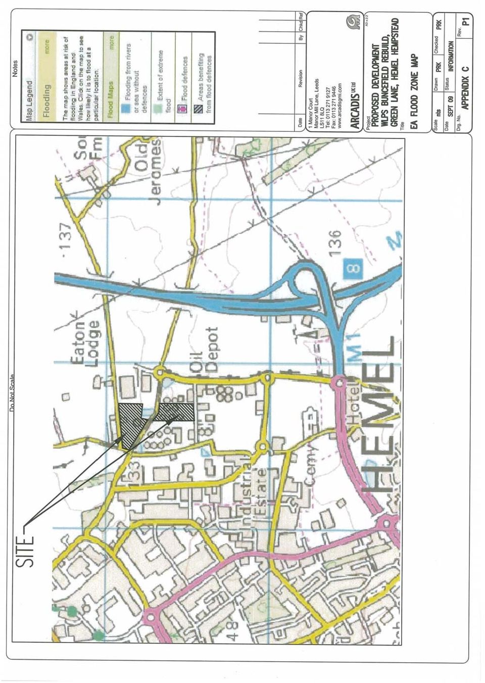
3 Flood Risk Assessment WLPS Buncefield Rebuild 92802_01 / September 2009 TABLE OF CONTENTS 1. INTRODUCTION Objectives Scope of Work SITE SETTING Topography and Site Setting (See Appendix A) Existing Site Drainage Geology and Hydrogeology Historical Flooding PROPOSED DEVELOPMENT (SEE APPENDIX B) PLANNING CONTEXT PPS25 - Development and Flood Risk Environment Agency Standing Advice SOURCES OF FLOODING Fluvial Flood Risk Overland Flow Groundwater Flooding Surcharged Sewer Flooding DEVELOPMENT AND FLOOD RISK MANAGEMENT Mitigation of Flood Risk On-Site Mitigation of Flood Risk Off-Site CONCLUSIONS...8 Figures 1 Site Location Plan Appendices A B C Historical Site Layout Proposed Site Layout Environment Agency Flood Zone Mapping

4 Flood Risk Assessment WLPS Buncefield Rebuild 92802_01 / September INTRODUCTION Arcadis UK Limited (ARCADIS) has been commissioned by British Pipeline Agency Limited as agent for West London Pipeline and Storage Limited and United Kingdom Oil Pipelines Limited to undertake a Flood Risk Assessment for a site at Green Lane, Hemel Hempstead ( the Site ). The site is currently developed and is partially operating as an oil product storage facility. The site is to be redeveloped to restore the storage capacity for Jet A1 aviation fuel to the same amount as was stored on-site prior to an incident in 2005 that damaged storage tanks rendering them unusable. 1.1 Objectives The objective of the study is to undertake a Flood Risk Assessment in accordance with Planning Policy Statement 25 (PPS25) Development and Flood Risk. This report also incorporates an outline drainage strategy for the disposal of foul and surface water flows from the development based on currently available information. Mitigation measures have been included to demonstrate that the site is not at risk of flooding and the proposed development will not increase flood risk to properties elsewhere. 1.2 Scope of Work The appraisal process comprises a desk study, data research and site visit to ascertain the extent of information available and identify any constraints with regard to drainage and flood risk that may affect the site. The assessment is a holistic risk based assessment of potential flooding from various sources including fluvial flooding, groundwater and surface water run-off. The assessment also examines residual flood risk and proposes mitigation to offer protection against flooding for the lifetime of the development.

5 Flood Risk Assessment WLPS Buncefield Rebuild 92802_01 / September SITE SETTING 2.1 Topography and Site Setting (See Appendix A) The site area is approximately 5 Hectares located within the Buncefield Oil Storage Terminal off Green Lane, Hemel Hempstead around National Grid Coordinates , and is approximately 2 km to the north east of Hemel Hempstead town centre. The areas immediately adjacent to the site are a mix of retail/commercial and industrial units and agricultural land. The surrounding land uses are summarised in Table 1.1. Table 1.1 Summary of Surrounding Land Uses North East South West Punchbowl Lane and agricultural land is located immediately to the north of the application site with some scattered residences. The closest residence is located approximately 50m from the application site boundary. The application site is bordered by undeveloped grassland and an area owned by Hertfordshire Oil Storage Limited. Beyond this is Green Lane with agricultural land and the M1 motorway located 0.75km further to the east of the application site. To the south of the application site is a road providing access to the surrounding fuel storage and distribution facilities. Beyond this is the BP facility and further facilities for industrial/commercial use. The land to the west of the application site is owned by Hertfordshire Oil Storage Limited. Beyond this is a mixed use industrial estate approximately 500m from the application site. The nearest watercourse is located in Pratt s Dell approximately 1km to the northwest of the site which drains to a surface water-balancing pond adjacent to Redbourn Road. The outlet from the pond discharges to the River Red which flow northwest and ultimately discharges to the River Ver at Redbourne approximately 4 km northeast of the site. The overall topography across the site falls from southwest to northeast. Land to the north of Cherry Tree Lane rises forming a valley. Cherry Tree Lane which bisects the site has an overall fall to the east towards the M1 Motorway although there is a localised low spot to the in the vicinity of the site. 2.2 Existing Site Drainage The site is currently developed as an oil storage depot and is almost entirely covered in hardstandings which are drained by a traditional system of pipes and gullies/drainage channels that discharge to an effluent treatment works (ETW) in the northeast corner of the main site. The outlet from the ETW is pumped to Pratt s Dell watercourse at a restricted rate of 7.5 l/s with surplus flows attenuated in a storage lagoon. Bunded areas surrounding storage tanks are isolated from the drainage system and periodically emptied, draining to the ETW during times of low flow to prevent accumulation of rainwater within the bunds. The main foul drain is located beneath the southern access road (Oil Road), collecting flows from the various terminals and discharging to a foul water pumping chamber located at the main entrance to the site adjacent to Green Lane. Submersible pumps lift the water into a pumping main which discharges to an adopted sewer in Boundary Way further south of the site.

6 Flood Risk Assessment WLPS Buncefield Rebuild 92802_01 / September Geology and Hydrogeology The BGS geology maps and borehole logs indicate the solid geology beneath the site to comprise Cretateous Upper Chalk. Deposits of the Tertiary Woolwich and Reading Beds are indicated near to the surface close to the western boundary. Drift deposits are indicated as Pleistocene (clay with Flints) of varying thickness. The underlying Upper Chalk is described by the EA as highly permeable strata that generally has a known or probable presence of fracturing and may be highly productive. The site is shown on the Environment Agency groundwater vulnerability maps as being underlain by a Major Aquifer which can reasonably be assumed to be defined as a Principal Aquifer under the new classification scheme which is currently being introduced. The site is close to the boundary of a Total Catchment Source Protection Zone (SPZ111) defined by the EA as the total area needed to support removal of water from a borehole and to support any discharge from the borehole. Groundwater flow in the vicinity of the site is understood to be generally to the east. 2.4 Historical Flooding There is a local hollow on Cheery Tree Lane where it bisects the site. This area is known to have flooded with firewater and foam during the 2005 incident.

7 Flood Risk Assessment WLPS Buncefield Rebuild 92802_01 / September PROPOSED DEVELOPMENT (SEE APPENDIX B) The application site comprises two sections which are located either side of Cherry Tree Lane. Cherry Tree Lane is the boundary between Dacorum Borough Council and St Albans City & District Council. The proposed redevelopment will consist of hardstandings and above ground oil storage tanks that will be located within bunded areas together with tertiary containment provision in the form of additional bund walls and a lagoon. The existing Effluent Treatment Works will be retained. A copy of the proposed redevelopment plan is included in Appendix B. The site is the former Buncefield Oil Storage Depot which has continued to operate on a reduced scale following an incident in 2005 that resulted in damage to much of the oil storage facility. The site is crossed by several supply pipelines that facilitate delivery of fuel to and from the site. The previous facility consisted almost entirely of hardstanding. As such the site should be considered as brown field development. The proposed redevelopment will result in an increase in impermeable area.

8 Flood Risk Assessment WLPS Buncefield Rebuild 92802_01 / September PLANNING CONTEXT 4.1 PPS25 - Development and Flood Risk The site is located within Flood Zone 1 (low risk) as defined on the Environment Agency Flood Zone Maps. This is land designated as having an annual probability of fluvial flooding from rivers of less than 0.1% (less than a 1 in 1000 annual probability of flooding) in any given year (See Appendix C). In Flood Zone 1, developers and regulatory authorities should seek opportunities to reduce the overall level of flood risk in the area and beyond through layout and form while applying sustainable drainage techniques where appropriate and practical. The sequential test within PPS25 aims to steer all new development to areas at the lowest risk of flooding. The site is located in FZ1 and therefore meets the requirements defined in Table 2 of PPS25 and the type of proposed development is appropriate for this location. 4.2 Environment Agency Standing Advice For a site of greater than 1 hectare located in Flood Zone 1 the Environment Agency standing advice is that they should be consulted as part of the planning process. A flood risk assessment, focussing mainly on the management of surface water run-off to demonstrate that the development will not increase flood risk to itself or elsewhere within the catchment should be provided in support of a planning application.

9 Flood Risk Assessment WLPS Buncefield Rebuild 92802_01 / September SOURCES OF FLOODING 5.1 Fluvial Flood Risk The site is shown located in Flood Zone 1 (low risk) on the Environment Agency mapping which is land that has a probability of flooding less than 0.1% (1 in 1000 years). There are no watercourses in the immediate vicinity of the site, therefore the risk of fluvial flooding is considered negligible. 5.2 Overland Flow Flooding from overland flow is considered unlikely. The general topography falls from southwest to northeast. The areas to the south and west of the site are developed and drained by a traditional piped system that should deal with surface run-off in all but the most extreme rainfall events. Should overland flow occur this would be expected to be short term and shallow in depth. 5.3 Groundwater Flooding In view of the localised topography and the fall across the site it is unlikely that groundwater will come out of the ground within the operational areas of the site during a rise in water table level. 5.4 Surcharged Sewer Flooding The site is currently served by a private drainage system that discharges to an effluent treatment works in the northeast corner of the site. In the event of surcharge flow due to lack of hydraulic capacity during extreme rainfall events there may be occasional short term surface flooding which would be contained on-site. The rebuild will increase impermeable areas that will discharge to the on-site drainage system.

10 Flood Risk Assessment WLPS Buncefield Rebuild 92802_01 / September DEVELOPMENT AND FLOOD RISK MANAGEMENT 6.1 Mitigation of Flood Risk On-Site Surface water drainage systems have the potential to flood under extreme conditions. Current drainage design standards generally require no surface flooding from the piped system for a 1 in 30 year storm. Development of the site will not affect existing overland flow routes. The proposed secondary/tertiary containment bunds and lagoon will be isolated with no direct discharge to the overall site drainage system. This will result in shallow short term surface ponding of rainwater within the containment bunds and storage lagoon during rainfall. The bunds will be emptied by pumping liquid to the Effluent Treatment Works at times of low flow to prevent overloading of the system. Other hardstandings will continue to drain to the existing below ground surface water drainage system which ultimately discharges to the Effluent Treatment Works. 6.2 Mitigation of Flood Risk Off-Site Requirement H3 of the Building Regulations 2000 states that the preferred hierarchy for disposal of surface water is infiltration then watercourse then sewer. In view of the historical/proposed use of the site and the strategic nature of the underlying aquifer it is considered inadvisable to discharge surface water run-off from the proposed development into the ground using infiltration techniques. The nearest suitable water feature with potential for discharge of surface run-off from the proposed development is the watercourse in Pratt s Dell to the northwest of the site. The site currently drains to Pratt s Dell via the Effluent Treatment Works which will continue to discharge to watercourse at the consented rate of 7.5 l/s. The proposed redevelopment will generate only nominal foul flows which will continue to discharge to foul pumping station at the site entrance for discharge to the existing public sewers to the south of the site.

11 Flood Risk Assessment WLPS Buncefield Rebuild 92802_01 / September CONCLUSIONS The site is shown as lying within Flood Zone 1 (low risk) on the Environment Agency mapping. The nearest watercourse is 1 km to the northwest of the site therefore the risk of Fluvial Flooding is considered to be negligible. It is recommended that finished floor and external pavement levels are set to direct water away from buildings. This would protect against water entering the building due to drainage infrastructure failure, overland flows or groundwater. Surface Water run-off will not impact on the Effluent Treatment Works serving the whole site which will continue to discharge at the restricted rate of 7.5 l/s to the watercourse in Pratt s Dell to the northwest of the site. Foul drainage from the development will discharge to the private sewers within Oil Road and will be pumped to the public sewers in Boundary Way to the south of the site. The proposed development is not at risk of flooding and will not result in an increased flood risk elsewhere in the catchment. This flood risk assessment and outline drainage strategy is based on a review of currently available information and is considered to be appropriate to the scale and nature of the development.

12 Figure 1 Site Location Plan

13

14 Appendix A Existing Site Layout

15

16 Appendix B Proposed Site Layout

17

18 Appendix C Environment Agency Flood Zone Mapping

19
20

Vital Earth Composting Facility Flood Risk and Drainage Statement
 Vital Earth Flood Risk and Drainage Statement Final December 2011 Prepared for Vital Earth Ltd Revision Schedule Flood Risk and Drainage Statement December 2011 Rev Date Details Prepared by Reviewed by
FLOOD RISK ASSESSMENT AND DRAINAGE STRATEGY
 FLOOD RISK ASSESSMENT AND DRAINAGE STRATEGY London Rd. WATERLOOVILE FOR McCarthy & Stone Ltd. July 2010 Such Salinger Peters Ltd 30558-1- Flood Risk Assessment & Drainage Strategy Contents Paragraph Page
FLOOD RISK AND SURFACE WATER DRAINAGE ASSESSMENT HILLHOUSE RESTORATION SITE, OFF JAMESON ROAD, THORNTON CLEVELEYS ON BEHALF OF NPL ESTATES
 FLOOD RISK AND SURFACE WATER DRAINAGE ASSESSMENT HILLHOUSE RESTORATION SITE, OFF JAMESON ROAD, THORNTON CLEVELEYS ON BEHALF OF NPL ESTATES Integra Consulting Engineers Limited NS / 2543 Fountain House
Proposed Construction of Basement Flood Risk Assessment. 35 Edwardes Square London W8 6HH
 Proposed Construction of Basement Flood Risk Assessment 35 Edwardes Square London W8 6HH 1 Introduction This FRA has been carried out in accordance with the National Planning Policy Statement (NPPF), the
Chapter 9: Water, Hydrology and Drainage Land West of Uttoxeter
 Chapter 9: Water, Hydrology and Drainage Land West of Uttoxeter ENVIRONMENTAL STATEMENT: VOLUME 1 9.1 INTRODUCTION 9.1.1 This Chapter considers the effects of the Project on surface water and groundwater
Taylor Wimpey UK Ltd. December 2007
 Taylor Wimpey UK Ltd December 2007 QM Issue/revision Issue 1 Revision 1 Revision 2 Revision 3 Remarks Draft For Planning Date 3 August 2007 20 December 2007 Prepared by D Gooding P Barton Signature Checked
Flood Risk Assessment Breakspear House, Hemel Hempstead. Kier Property. October 08
 Flood Risk Assessment Breakspear House, Hemel Hempstead. Kier Property October 08 Prepared by:... Approved by:... Simon Marcos Keith Searle Principal Engineer Associate Director Flood Risk Assessment Rev
Littleport Co-located Schools
 Littleport Co-located Schools February 2015 Morgan Sindall Littleport Co-located Schools 330763 BNI BSE 003 C P:\Cambridge\Murdoch\EST\PROJECTS\330763 Littleport Co-located Schools\12.0 Documents\12.2
DRAINAGE MANAGEMENT PLAN. HERTFORDSHIRE RESIDUAL WASTE TREATMENT PLANT Hertfordshire County Council
 DRAINAGE MANAGEMENT PLAN HERTFORDSHIRE RESIDUAL WASTE TREATMENT PLANT Hertfordshire County Council EMPLOYER: Veolia Environmental Services (UK) Plc Veolia House 154A Pentonville Road London N1 9PE Copy
Recommendations for future developments
 C Recommendations for future developments C.1 Reducing flood risk through site layout and design C.1.1 C.1.2 Flood risk should be considered at an early stage in deciding the layout and design of a site
Flood Risk Assessment and Drainage Statement
 Trinity College, Cambridge Proposed Relocation of Felixstowe Rifle Range, Land north of Nicholas Road, Trimley St Mary, Felixstowe Quality Assurance Site name: Client name: Proposed Relocation of Felixstowe
Proposed Residential Development Land off Cody Road Waterbeach Cambridgeshire. Flood Risk Assessment
 Land off Cody Road Waterbeach Cambridgeshire Cedar Barn, White Lodge, Walgrave, Northampton, NN6 9PY T: F: E: W: 01604 781811 01604 781999 mail@jppuk.net jppuk.net Proposed Residential Development Land
Action plans for hotspot locations - Ash Study
 Appendix 9 Action plans for hotspot locations - Ash Study Ash Vale North 1. Local evidence indicates the culvert could not discharge during December 2013 because the outlet was blocked on the western side
London Borough of Waltham Forest LOCAL FLOOD RISK MANAGEMENT STRATEGY. Summary Document
 LOCAL FLOOD RISK MANAGEMENT STRATEGY Summary Document October 2013 Local Flood Risk Management Strategy Summary 1 Introduction 2 Partner responsibilities 3 What do we know about flooding in the borough?
1.2 This technical note provides a preliminary investigation into the Flood Risk and provides outline drainage strategies.
 ODYSSEY MARKIDES TECHNICAL NOTE PROJECT : CHAILEY HOUSE, BLEWBURY JOB NO. : 14-216 NOTE TITLE : PRELIMINARY FLOODING AND DRAIANGE AUTHOR : STEVEN ROOTH APPROVED : ANDREAS MARKIDES DATE : 02/09/2014 1.0
NOVEMBER 2009 [ISSUE 5]
![NOVEMBER 2009 [ISSUE 5]](/thumbs/28/12834647.jpg "NOVEMBER 2009 [ISSUE 5]") 375 401 BRIGHTON ROAD CROYDON FLOOD RISK ASSESSMENT CLIENT: TRITHING LTD [ISSUE 5] Head Office: Unit 2 York House Edison Park Dorcan Way Swindon Wiltshire SN3 3RB Tel. 01793 619965 Fax. 01793 619967 Email:
375 401 BRIGHTON ROAD CROYDON FLOOD RISK ASSESSMENT CLIENT: TRITHING LTD [ISSUE 5] Head Office: Unit 2 York House Edison Park Dorcan Way Swindon Wiltshire SN3 3RB Tel. 01793 619965 Fax. 01793 619967 Email:
Newbiggin House Farm,
 Newbiggin House Farm, Near Waberthwaite Flood Investigation Report 32 Flood Event 30/8/2012 Cumbria County Council Version Undertaken by Reviewed by Approved by Date Preliminary Colin Parkes Anthony Lane
Groundwater Flooding: a UK Perspective
 Groundwater Flooding: a UK Perspective David Macdonald British Geological Survey Maclean Building Crowmarsh Gifford Wallingford OX10 8BB Tel 01491 838800 NERC All rights reserved Talk outline Definition
APPENDIX 9 INFRASTRUCTURE SERVICING REPORT
 APPENDIX 9 INFRASTRUCTURE SERVICING REPORT Lot 50 Cockram Street, Mundijong Infrastructure Servicing Report Peet Ltd August 2012 LOT 50 COCKRAM STREET, MUNDIJONG-INFRASTRUCTURE SERVICING REPORT Project
Flood Risk Assessment and Drainage Impact Assessment: Planning Guidance for Developers
 Flood Risk Assessment and Drainage Impact Assessment: Planning Guidance for Developers Development and Regeneration Services Glasgow City Council 229 George Street Glasgow G1 1QU May 2011 1. Introduction...-
Sutton Harbour Holdings PLC. March 2007
 Sutton Harbour Holdings PLC March 2007 Contents!! " # # $ % % &'(&'' ) ) ( * + ', *!$ -,!'! #. / $$ #% 00& ' 00&1 $ Executive Summary!! " WSP Development and Transportation has been engaged by Sutton
Report Relating to Incidents of Flooding within the Dollar Catchment
 Joint Position Statement Report Relating to Incidents of Flooding within the Dollar Catchment October 2012 Eric McQuarrie, Scottish Water Stuart Cullen, Clackmannanshire Council TABLE OF CONTENTS 1. INTRODUCTION...
Development at 2 St Albans Road, Kingston, London, KT25HQ
 Development at SuDS Report. Prepared for: Report prepared by: Dave Alonso Divine Ideas (UK) ltd Date: August 2015 Project/Issue number: Appendices Attached: 1510/01/SuDS A, B & C Divine Ideas (UK) Ltd
(http://www.molevalley.gov.uk/media/pdf/c/r/srfa_-_updated_jnauary_2012.pdf
 Possible Submission about Water and Flooding (See maps 3a and 3b) From Mole Valley Local Development Framework: Strategic Flood Risk Assessment Update 2012 (http://www.molevalley.gov.uk/media/pdf/c/r/srfa_-_updated_jnauary_2012.pdf
London Road, Rayleigh Essex Flood Risk Assessment Addendum
 FINAL Countryside Properties (UK) Limited Submitted by AECOM 6-8 Greencoat Place London SW1P 1PL London Road, Rayleigh Essex Flood Risk Assessment May 2015 i Limitations AECOM Infrastructure & Environment
Strategic Flood Risk Assessment
 local development framework Strategic Flood Risk Assessment LOCAL DEVELOPMENT FRAMEWORK ROYAL BOROUGH OF KINGSTON UPON THAMES Level 1 and 2 April 2011 Contents Executive Summary 5 Part 1 - Aiding Planning
Planning, Health and Environment Division
 18 Planning, Health and Environment Division A Planning Guide to Sustainable Drainage Systems Introduction Working in co-operation with the Environment Agency, Severn Trent Water Ltd., the Highway Authority
GUIDE TO SETTLEMENT OF CANTERBURY FLAT LAND CLAIMS
 GUIDE TO SETTLEMENT OF CANTERBURY FLAT LAND CLAIMS April 2013 i Introduction This guide focuses on repair methods for some of the types of land damage that occurred on flat residential land as a result
Creating the environment for business
 1. Introduction 1.1 Introduction to Water Cycle Strategies (WCS) 1.1.1 Background The water cycle describes the pathways and processes through which water moves through the natural and built environment,
Proposed Re-development, At 321 London Road, Wyberton. Flood Risk Assessment - Revised
 Proposed Re-development, At 321 London Road, Wyberton Flood Risk Assessment - Revised Prepared By: C Mason C.Eng M.I.C.E May 2015 Contents Page No. 1. Introduction 2 2. Site Description 2 3. Flood Hazard
East Riding of Yorkshire Council
 East Riding of Yorkshire Council Lead Local Flood Authority Interim Standing Advice Revision A - April 2015 1. Introduction From April 2015 the Lead Local Flood Authority (LLFA) became a statutory consultee
Introduction. The vision of the West Yorkshire Combined Authority (WYCA) Flood Risk Partnership
 Flood Risk Partnership") WYCA SuDS Guidance Introduction As part of the government s continuing commitment to protect people and property from flood risk, the Department for Communities and Local Government and the Department
WYCA SuDS Guidance Introduction As part of the government s continuing commitment to protect people and property from flood risk, the Department for Communities and Local Government and the Department
London Borough of Croydon Local Flood Risk Management Strategy
 London Borough of Croydon Local Flood Risk Management Strategy Summary 2014-2020 Introduction In response to the severe flooding across large parts of England and Wales in summer 2007, the Government has
11.2 The proposals to deal with the leachate within the closed Lodmoor North Landfill site are assessed in Chapter 10 Geology and Soils.
 Chapter Eleven Water Quality, Drainage and Hydrogeology Introduction 11.1 This Chapter considers the impact of the Relief Road on the hydrology of the area and considers both surface and groundwater. Runoff
London Borough of Merton Local Flood Risk Management Strategy
 Local Flood Risk Management Strategy Summary 2014-2020 Introduction In response to the severe flooding across large parts of England and Wales in summer 2007, the Government has recently enacted the Flood
Designed and produced by geo-graphicsdesign.com DP 300 3/02
 Designed and produced by geo-graphicsdesign.com DP 300 3/02 Guidance for Developers and Regulators Purpose This booklet is produced on behalf of the North East Scotland Flooding Advisory Group and is intended
Flood Risk Assessment
 Flood Risk Assessment Suffolk Agricultural Association Trinity Park, Ipswich July 212 Suffolk Agricultural Association Trinity Park, Ipswich July 212 Quality Assurance Site name: Client name: Trinity Park,
DECEMBER 2008 [ISSUE 2]
![DECEMBER 2008 [ISSUE 2]](/thumbs/40/21568937.jpg "DECEMBER 2008 [ISSUE 2]") PROPOSED DEVELOPMENT WEST SUSSEX FLOOD RISK ASSESSMENT CLIENT: ARORA MANAGEMENT SERVICES LIMITED [ISSUE 2] Warrington Office Cinnamon House Cinnamon Park Crab Lane Fearnhead Warrington Cheshire WA2 0XP
PROPOSED DEVELOPMENT WEST SUSSEX FLOOD RISK ASSESSMENT CLIENT: ARORA MANAGEMENT SERVICES LIMITED [ISSUE 2] Warrington Office Cinnamon House Cinnamon Park Crab Lane Fearnhead Warrington Cheshire WA2 0XP
ENVIRONMENTAL STATEMENT: VOLUME 2 APPENDICES 11.1 TO 11.3
 NORTH LONDON WASTE AUTHORITY NORTH LONDON HEAT AND POWER PROJECT ENVIRONMENTAL STATEMENT: VOLUME 2 APPENDICES 11.1 TO 11.3 AD06.02 NORTH LONDON WASTE AUTHORITY NORTH LONDON HEAT AND POWER PROJECT ENVIRONMENTAL
Guidance on the use of sustainable drainage systems (SUDS) and an overview of the adoption policy introduced by
 and an overview of the adoption policy introduced by") Guidance on the use of sustainable drainage systems (SUDS) and an overview of the adoption policy introduced by Easy guide to Sustainable drainage systems 02 Contents Page Introduction 05 Purpose of this
Guidance on the use of sustainable drainage systems (SUDS) and an overview of the adoption policy introduced by Easy guide to Sustainable drainage systems 02 Contents Page Introduction 05 Purpose of this
PPG21. Pollution Prevention Guidelines. pollution incident response planning: PPG 21. 1. Introduction
 PPG21 February 2004 Environmental Alliance working together Pollution Prevention Guidelines pollution incident response planning: PPG 21 These guidance notes have been drawn up to assist those developing
Granville Road Estate, London Borough of Barnet. Flood Risk Assessment and Drainage Strategy August 2014. New Granville LLP
 Granville Road Estate, London Borough of Barnet Flood Risk Assessment and Drainage Strategy August 2014 New Granville LLP Document History JOB NUMBER: 237 DOCUMENT REF: Granville Road FRA REVISIONS: Final
Building over or close to a public sewer
 Building over or close to a public sewer thameswater.co.uk/developerservices thameswater.co.uk/developerservices 1 Questions and answers Did you know Thames Water is legally responsible for more than 100,000
SUSTAINABLE URBAN DRAINAGE SYSTEMS
 overflow can lead into a permeable conveyance system to increase further the benefit and reduce the need for pipe systems. Pollutant removal rates have been shown to be high, with some pollutants being
Parish Flood Report: Broadwell & Kencot
 Parish Flood Report: Broadwell & Kencot Version 1 This report may be revised in the future to incorporate ongoing consultation results Boardwell & Kencot Flood Report 1 of 37 June 2008 Contents 1.0 INTRODUCTION...3
Urban Flood Modelling
 Urban Flood Modelling Adrian J Saul Pennine Water Group Department of Civil and Structural Engineering University of Sheffield a.j.saul@sheffield.ac.uk 1 Need for Integrated Urban Drainage within an integrated
Land to the rear of the Black Bull Public House Flood Risk Assessment March 10, 2014 Version 1.0 Ref: RAB 148
 Land to the rear of the Black Bull Public House Flood Risk Assessment March 10, 2014 Ref: RAB 148 Lindsey Phillips Turnbull Tweedale Ltd 61 Oaken Lanes Codsall South Staffordshire WV8 2AW R A B C O N S
FLOOD RISK ASSESSMENT
 SEVERN ROAD RESOURCE RECOVERY CENTRE FLOOD RISK ASSESSMENT REF 402.0036.00374 September 2009 Severn Road Resource Recovery Centre Ref: 402-0036-00374 Viridor Waste Management i PPS25 Flood Risk Assessment
WILLOCHRA BASIN GROUNDWATER STATUS REPORT 2009-10
 WILLOCHRA BASIN GROUNDWATER STATUS REPORT 2009-10 SUMMARY 2009-10 The Willochra Basin is situated in the southern Flinders Ranges in the Mid-North of South Australia, approximately 50 km east of Port Augusta
E19: SUSTAINABLE PLACEMENT OF SURPLUS EXCAVATED MATERIAL
 HIGH SPEED TWO INFORMATION PAPER E19: SUSTAINABLE PLACEMENT OF SURPLUS EXCAVATED MATERIAL This paper outlines the approach to sustainable placement of surplus excavated material for Phase One of the HS2
Groundwater Flooding in Brighton and Hove City (February 2014)
") Section 19 Flood Investigations Report Groundwater Flooding in Brighton and Hove City (February 2014) May 2014 Revision Schedule Rev Date Details Author Checked and Approved by 1 April 2014 M Moran N Fearnley
Section 19 Flood Investigations Report Groundwater Flooding in Brighton and Hove City (February 2014) May 2014 Revision Schedule Rev Date Details Author Checked and Approved by 1 April 2014 M Moran N Fearnley
The application site is on the edge of flood zones 1 and 2 with flood zone boundary cutting across part of the southern boundary of the site.
 Flood Risk Assessment Erection of Masjid/ Place of Worship, extended car parking following demolition of 11a Grafton Street & boundary treatment Land adjacent 11/ 11a Grafton Street, Preston, PR1 8JB 0723/
Essex County Council Flood Investigation Report
 Essex County Council Stock City of Chelmsford Rev Date Details Author Checked and Approved By 01 February 2015 Draft report for stakeholder consultation Ed Clarke Flood Investigation Engineer Lucy Shepherd
Pollution Control NEW! NEW! Stormwater Attenuation Systems Sustainable Urban Drainage Solutions for Domestic & Commercial Applications. klargester.
 Pollution Control NEW! NEW! Stormwater Attenuation Systems Sustainable Urban Drainage Solutions for Domestic & Commercial Applications klargester.com Stormwater Attenuation Systems Sustainable Urban Drainage
Development proposals will require to demonstrate, according to scale, type and location, that they:-
 Appendix 2 : Relevant Development Plan Policies Angus Local Plan Review 2009 Policy S1 : Development Boundaries (a) Within development boundaries proposals for new development on sites not allocated on
Type of Sewer Systems. Solomon Seyoum
 Type of Sewer Systems Solomon Seyoum 0 Learning objectives Upon completion of this lecture, the participants will be able to differentiate between types of sewer systems and discuss different aspects of
Chippenham Surface Water Management Plan Intermediate Assessment of Groundwater Flooding Susceptibility
 Chippenham Surface Water Management Plan Intermediate Assessment of Groundwater Flooding Susceptibility Phase 1 & 2 November 2011 Prepared for Revision Schedule Surface Water Management Plan Intermediate
SUSTAINABLE DRAINAGE IN LEEDS Supplementary Guidance No. 22 JULY 2004
 SUSTAINABLE DRAINAGE IN LEEDS Supplementary Guidance No. 22 JULY 2004 BACKGROUND This guidance provides information for developers on the use of sustainable drainage techniques in new developments. It
Development enquiry request
 Development enquiry request Water supply and/or drainage capacity assessment for a proposed development NOTE: Please ensure all relevant sections of the application are completed and refer to the attached
MAGB HEALTH, SAFETY AND ENVIRONMENT GROUP POLLUTION INCIDENT RESPONSE PLAN
 MAGB HEALTH, SAFETY AND ENVIRONMENT GROUP POLLUTION INCIDENT RESPONSE PLAN SCOPE: This guidance sets out best practice for producing a Pollution Incident Response Plan to deal with an environmental incident
Sample FURTHER ACTION FLOOD RESIDENTIAL REPORT SUMMARY PROFESSIONAL OPINION. Address: Requested By: Date: Grid Ref: E: 123456 N: 123456.
 RESIDENTIAL 0.25HA REPORT SUMMARY SECTION 1: (INC. INSURABILITY) : NEXT STEPS: - CONSIDER PROTECTION SURVEY Address: 1 Lane, Street, Town Requested By: Conveyancing Liability Solutions Grid Ref: Date:
Issue: 2 Adopted by Council: 20/02/07. Directorate of Environment and Regeneration Planning Services
 Issue: 2 Adopted by Council: 20/02/07 Directorate of Environment and Regeneration Planning Services LOCAL PLANNIING GUIIDANCE NOTE NO..19:: SUSTAIINABLE DRAIINAGE SYSTEMS Background The provision of adequate
2 ND SEPTEMBER 2014. Report of the Bi-Borough Executive Director for Transport and Technical Services
 London Borough of Hammersmith & Fulham COMMUNITY SAFETY, ENVIRONMENT & RESIDENTS SERVICES POLICY & ACCOUNTABILITY COMMITTEE 2 ND SEPTEMBER 2014 SURFACE WATER MANAGEMENT PLAN (SWMP) Report of the Bi-Borough
ORCHARD WAY / BROOM GROVE Knebworth
 ORCHARD WAY / BROOM GROVE Knebworth Technical Assessment Report to support Section 19 Flood Investigation Project No: Date: Reviewed By: Approved By: 0469 October 2014 Tom Butler Neil Harding NHTB Consultancy
Mr & Mrs Clarke Proposed Development at The River House, Balderstone Flood Risk Assessment
 Proposed Development at The River House, Balderstone D2192-FRA-01 5 Nov 2015 PSA Design Ltd Consulting Engineers The Old Bank House 6 Berry Lane Longridge Preston PR3 3JA Tel. 01772 786066 Fax. 01772 786265
1 in 30 year 1 in 75 year 1 in 100 year 1 in 100 year plus climate change (+30%) 1 in 200 year
 1 in 200 year") Appendix C1 Surface Water Modelling 1 Overview 1.1 The Drain London modelling was designed to analyse the impact of heavy rainfall events across each London borough by assessing flow paths, velocities
Appendix C1 Surface Water Modelling 1 Overview 1.1 The Drain London modelling was designed to analyse the impact of heavy rainfall events across each London borough by assessing flow paths, velocities
UPDATED FUNCTIONAL SERVICING and STORMWATER MANAGEMENT REPORT
 TRAFALGAR ENGINEERING LTD. #1-481 Morden Road Oakville Ontario L6K 3W6 UPDATED FUNCTIONAL SERVICING and STORMWATER MANAGEMENT REPORT Fernbrook Homes (Bronte 15) Limited 3059/3047 Lakeshore Road West TOWN
Flood Risk Management in Southwark
 Flood Risk Management in Southwark 1 Presented to Borough & Bankside Community Council 25 th April 2012 By Flood and Drainage Team Agenda Item 11 IN BRIEF Background Legislation What have we done? What
Homes and Environment Scrutiny Committee. (Environment & Transport)
") REPORT TO: REPORT NO: Homes and Environment Scrutiny Committee HHPPE/89/15S DATE: 9 September 2015 LEAD MEMBER: Councillor David A Bithell (Environment & Transport) CONTACT OFFICER: Neil Taunt (Tel: 729734)
REPORT TO: REPORT NO: Homes and Environment Scrutiny Committee HHPPE/89/15S DATE: 9 September 2015 LEAD MEMBER: Councillor David A Bithell (Environment & Transport) CONTACT OFFICER: Neil Taunt (Tel: 729734)
Household customer. Wastewater flooding guidelines. www.thameswateruk.co.uk
 Household customer Wastewater flooding guidelines www.thameswateruk.co.uk We are very sorry that you have recently suffered wastewater flooding to your property. This leaflet has been designed to answer
London Borough of Bexley. Bexley Strategic Flood Risk Assessment Level-1. Bexley SFRA Level-1 Report. August 2010
 London Borough of Bexley Bexley Strategic Flood Risk Assessment Level-1 Bexley SFRA Level-1 Report Copyright and Non-Disclosure Notice The contents and layout of this report are subject to copyright owned
Bolton s Flood Risk Management Strategy
 Bolton s Flood Risk Management Strategy www.bolton.gov.uk Public Summary Bolton s Flood Risk Management Strategy Public Summary Introduction Over 5.5 million properties in England and Wales are at risk
Thames Water key Messages for London Borough of Ealing 25 th October 2005
 Thames Water key Messages for London Borough of Ealing 25 th October 2005 Item 1: Drainage & ownership The area of drainage is complex. Thames Water, the Local Authority, the Environment Agency and property
Flood Risk Assessment. For Application at: Brick House Farm Brick House Lane Hambleton Lancashire FY6 9BG
 Flood Risk Assessment For Application at: Brick House Farm Brick House Lane Hambleton Lancashire FY6 9BG Contents 1. Introduction 2. The Site 3. Flood Risk 4. Existing drainage 5. Proposed Development
Chapter 2 Spatial Portrait
 15 November 2013 Dear Julie Fylde Local Plan to 2030 Part 1 Preferred Options Thank you for the opportunity to meet with you on 9 October in respect of the above mentioned document. As discussed at the
Development Management Report
 Committee and Date Central Planning Committee 5 th April 2012 Item 13 Public Development Management Report Responsible Officer: Stuart Thomas email: stuart.thomas@shropshire.gov.uk Tel: 01743 252665 Fax:
Guidance Notes: GARDEN FLOODING
 Page 1 of 7 Guidance Notes: GARDEN FLOODING If you are unsure about anything within these notes then please contact the Flood Risk Management (FRM) team using the details at the end of this document. Water
INFRASTRUCTURE, FLOOD PROTECTION AND REMEDIATION. Infrastructure Flood Protection Remediation Policies
 INFRASTRUCTURE, FLOOD PROTECTION AND REMEDIATION Infrastructure Flood Protection Remediation Policies DRAFT POOLBEG PLANNING SCHEME 196 FIGURE 9.1: UTILITIES WAYLEAVES Electricity Cables 8m Wayleave for
Defence College of Technical Training. Former RAF Lyneham Geo-Environmental Report 32655 Appendix D: Preliminary Qualitative Risk Assessment
 Item No. Area/ Building Pathway to 1 Identified areas of / (redevelopment Ingestion Inhalation Severe Likely High SKM Enviros desk study highlights several known areas of significant historical. Areas
Presentation on Flood Risk Management To Engineers Ireland 12 th February 2014. David Keane Cork County Council
 Presentation on Flood Risk Management To Engineers Ireland 12 th February 2014 David Keane Cork County Council 1 Contents 1. The Power of Water 2. Defenses 3. Flooding & Flood Types 4. Flood Mitigation
Sustainable Drainage Systems (SUDS) A guide for developers
 A guide for developers") Sustainable Drainage Systems (SUDS) A guide for developers We are the Environment Agency. It s our job to look after your environment and make it a better place for you, and for future generations. Your
Sustainable Drainage Systems (SUDS) A guide for developers We are the Environment Agency. It s our job to look after your environment and make it a better place for you, and for future generations. Your
Carterton Drainage Strategy. Stage 1 - Initialise/Prepare
 Carterton Drainage Strategy Stage 1 - Initialise/Prepare Introduction Why sewer flooding Britain s first sewerage systems were constructed 150 years ago in the Victorian era, and have served us well for
13 Water Resources and Flood Risk
 13 Water Resources and Flood Risk 13.1 Introduction 13.1.1 This chapter provides an assessment of the potential construction and operational impacts on water resources and flood risk associated with the
Sewer Flooding Alleviation in the Counters Creek Catchment
 Sewer Flooding Alleviation in the Counters Creek Catchment London Borough of Hammersmith and Fulham Monday, 14 November 2011 at 7.00pm The Small Hall, Hammersmith Town Hall, King Street, W6 9JU Agenda
Anglian Water Services Limited. Sustainable drainage systems (SUDS) adoption manual
 adoption manual") Anglian Water Services Limited i towards sustainable water stewardship Sustainable drainage systems (SUDS) adoption manual Anglian Water Services Limited 1 Tomorrow s forecast is more frequent, more violent
Anglian Water Services Limited i towards sustainable water stewardship Sustainable drainage systems (SUDS) adoption manual Anglian Water Services Limited 1 Tomorrow s forecast is more frequent, more violent
Foul Drainage, systems and responsibility. Environmental Protection
 Foul Drainage, systems and responsibility Environmental Protection The Building Act 1984 The Building Act 1984 can be used to deal with unsatisfactory provision for drainage and appliances which are harmful
Water and Flooding Position Statement
 Derby City Local Plan, Part 1: Core Strategy Water and Flooding Position Statement August 2015 1. Introduction 1.1 This position statement provides an update to the Derby HMA Joint Water Issues Paper which
Preliminary Environmental Information Report: Appendix 16.C. Flood Warning and Evacuation Plan
 Preliminary Environmental Information Report: Appendix 16.C Flood Warning and Evacuation Plan THIS PAGE IS LEFT INTENTIONALLY BLANK Page 2 of 30 Contents SUMMARY 1. INTRODUCTION... 9 1.1 Background...
Cole Easdon Consultants Limited
 FLOOD RISK ASSESSMENT FOR PROPOSED EXPANSION OF WHITEHALL GARDEN CENTRE CORSHAM ROAD, LACOCK ON BEHALF OF WHITEHALL GARDEN CENTRES LTD. OCTOBER 2015 [ISSUE 2] Head Office: Unit 2 York House Edison Park
A13 Water Resources and Flood Risk
 A13 Water Resources and Flood Risk A13.1 A13.2 Water Resources Baseline Report (Mott MacDonald) A13.1 Crown copyright and database rights 2014 Ordnance Survey 100035971 Transport and Works Act 1992 London
5. Environmental Analysis
 5.11 The potential for adverse impacts on utilities and service systems was evaluated based on information concerning current service levels and the ability of the service providers to accommodate the
To prevent increased stormwater runoff entering Council s drainage system and causing overloading of the system that in turn might cause flooding.
 Background & Issues To provide guidelines and requirements for Developers, the Community and the Shire s Planning and Sustainability officers for connection to the Shire s Stormwater Drainage Disposal
Managing Surface Water Flooding in Paddock Wood Briefing note - June 2011
 Managing Surface Water Flooding in Paddock Wood Briefing note - June 2011 Information for Editors What is the reason for this initiative? 1. Legal Requirements The main drivers are the Flood Risk Regulations
06 - NATIONAL PLUVIAL FLOOD MAPPING FOR ALL IRELAND THE MODELLING APPROACH
 06 - NATIONAL PLUVIAL FLOOD MAPPING FOR ALL IRELAND THE MODELLING APPROACH Richard Kellagher 1, Mike Panzeri 1, Julien L Homme 1, Yannick Cesses 1, Ben Gouldby 1 John Martin 2, Oliver Nicholson 2, Mark
90 Brighton Road, Surbiton, Surrey
 90 Brighton Road, Surbiton, Surrey Civil and Structural Engineering Basement Feasibility Report Mixed Use Scheme 108802-REP-002 March 2015 Contents 1. Executive Summary... 3 2. Site Description and Constraints...
SUFFOLK COUNTY DEPARTMENT OF HEALTH SERVICES TOXIC/HAZARDOUS MATERIAL TRANSFER FACILITY DESIGN GUIDELINES
 SUFFOLK COUNTY DEPARTMENT OF HEALTH SERVICES TOXIC/HAZARDOUS MATERIAL TRANSFER FACILITY DESIGN GUIDELINES 1.0 GENERAL 1.1 Article 12 of the Suffolk County Sanitary Code requires that toxic/hazardous material
Sample FURTHER ACTION FLOOD COMMERCIAL REPORT SUMMARY PROFESSIONAL OPINION. Address: Requested By: Date: Grid Ref: E: 123456 N: 123456.
 COMMERCIAL 0.25HA REPORT SUMMARY SECTION 1: (INC. INSURABILITY) : NEXT STEPS: - CONSIDER PROTECTION SURVEY Address: 1 Lane, Street, Town Requested By: Conveyancing Liability Solutions Grid Ref: Date: References:
The site is Lot 1 DP 837271. Survey of this lot and Willarong Road and Koonya Circuit is given in Figure 2.
 Our Ref : NA49913151-019-L02:BCP/bcp Contact: Dr Brett C. Phillips 8 th May 2015 Cardno (NSW/ACT) Pty Ltd ABN 95 001 145 035 The Manager Bunnings Group Limited, c/- C&M Consulting Engineers 1/142 James
Guidance on applying for approval of installation of a commercial onsite wastewater system
 Guidance on applying for approval of installation of a commercial onsite wastewater system This factsheet is designed to assist you to complete an Application to construct or install an apparatus for the
PE21 7JE LEVEL 2 FLOOD RISK ASSESSMENT
 IE14/014/ymc Proposed Marstons Public House Swineshead Road Wyberton Fen Boston Lincolnshire PE21 7JE LEVEL 2 FLOOD RISK ASSESSMENT SUFFOLK: Registered Office: 7 Museum Street Ipswich Suffolk IP1 1HQ T