ipot project Industrial Potato monitoring for the Belgian potato sector
|
|
|
- Roxanne Thornton
- 8 years ago
- Views:
Transcription

")
1 ipot project Industrial Potato monitoring for the Belgian potato sector Yannick Curnel, Jean-Pierre Goffart, Viviane Planchon (CRA-W) Version 25/04/2014
")
2 Financed by : BELSPO Project of 36 month 01/06/ /05/2017 Collaborations o o o BELGAPOM (leader) Romain Cools VITO Isabelle Piccard, Kris Nackaerts ULg (Campus Arlon) Bernard Tychon
")
 More & more contracts with farmers Crop consulting between")

3 ipot project Context Belgian potato sector Fast growing sector of the Belgian food industry (largest exporter of potato products & largest importer of potatoes) More & more contracts with farmers Crop consulting between factories & traders growers Necessity to realise higher yields in a sustainable way ipot on line follow up of the potato parcels in order to control and improve potato quality and volume Potatoes

4 ipot project Context Belgium is since the 17th biggest potato producer of the world, Nowhere in the world higher yields are obtained than in Belgium (FAO statistics, 2011) potato is the fourth most important food crop with respect to production in Belgium - potato production (in tons) per inhabitant, Belgium is ranked on the 4th place with a production of 395,5 tons per 1000 inhabitants (WES report, 2013). Industrial potatoes represent around 80% of the total potato cropped area in Belgium. The Belgian potato processing industry evolved to the world s largest exporter of frozen potato products Belgapom (union of the potato trade and processing industry) is the active platform for the industry, trying to gather the industry in its way towards a sustainable growth.
 is the active platform for")
5 ipot project Context processors, traders and packers are increasingly working with potato contracts - follow up of the contracted potato parcels in order to control and improve potato quality and volume, in close relationship with the farmer - follow up of these fields on the land as well as from above is becoming an important tool to improve the quantity and quality of the potato crop The ipot project aims to bridge the gap between the latest research efforts regarding crop growth monitoring and the industry.

6 ipot project User needs Information for decision making on Crop management in specific parcels Destination of potatoes (processing vs. fresh market) For commercial negotiations Specific needs The following monitoring techniques are considered as essential information to contribute to a better quality and quantity management of the production : Potato yield and quality information (tuber size and under water weight) to decide on haulm killing and/or harvesting; Real-time information on potato growth and development (phenology) as physical follow up / sampling by industry experts is difficult given the increase in acreage and larger parcels with large within field variability; Information on crop and soil moisture, temperature and solar radiation to allow crop risk assessment for diseases or deformations; wallon de Recherches agronomiques Soil information forcentre potato cultivation Département Agriculture et Milieu naturel

7 General objective To provide information on potato growth and development at field level and yield estimates a forecasts to the Belgian potato sector by means of a web-based geo-information platform

8 Specific objectives To develop - in close collaboration with the users - information products for potato crop growth monitoring based on the integration of field observations, close range sensing measurements, satellite images and crop growth models To set up a web based geo-information platform that can be used by the potato processing industry, research centres and farmers to retrieve information at field level for exchange of field data between the industry and research groups To demonstrate the service and products in near-real time in 2015 and 2016

9 Specificobjective An intuitive web based geo-information platform will be developed for both the Belgian potato processing industry and research centres focussing on the cultivation of the potato crop as an answer to specific challenges and information needs. Continuous yield estimates and crop growth monitoring are on the top of the industry s priority list


10 Methodology
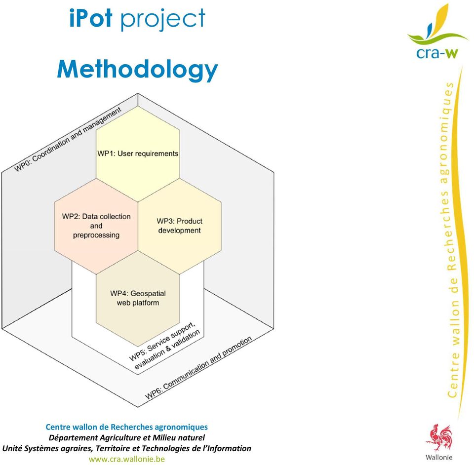
11 Methodology/ expected results A combination of EO and modelling techniques will be used to investigate these issues and to develop practical solutions in the form of geo-referenced maps and graphs accessible via a web based interface. A multi-scale approach is proposed, integrating field observations and close range sensing measurements with UAV and satellite images taken at regular intervals during the growing season (for crop monitoring) and with crop growth models (for yield assessment). Through the involvement of Belgapom (as project coordinator) and its members the applicability and future use of the developed products will be ensured. The processing industry, their network of potato farmers as well as the regional and provincial potato research institutes will provide the necessary inputs, i.e. field measurements and expertise, for product development. The involvement of the research institutes will also ensure the dissemination of the project results to the wider farmer community.
 and with crop growth models (for yield assessment).")
12 Methodology Crop growth monitoring Maps can be derived on a regular basis with for each pixel the actual development stage of the potato crop Crop emergence maps will illustrate the time (date) and degree of crop emergence and crop closure (in terms of % cover) Crop senescence maps will reflect the % cover of non-photosynthetic active vegetation Field condition monitoring Photosynthetic activity and hence vegetation productivity Vegetation moisture status Soil Moisture Temperature and solar radiation

13 Methodology Multi-scale approach for potato monitoring and yield estimation, integrating field observations and close range sensing measurements with UAV and satellite images and with crop growth models. Remote sensing data (DMC, S2, SPOT, RapidEye, ) available via BELAIR and JECAM Field data collected / provided by the industry, potato research centres, government, research partners Set up of a user-friendly web based geo-information platform for data exchange Close interaction with the users (data collection, product development, validation, evaluation)

14 Field condition monitoring Objective: monitoring field and crop condition to assess risk of yield or quality losses fapar from HR satellite sensors to estimate the crop s photosynthetic activity Vegetation moisture via NDWI, GVMI, Soil moisture via Soil Moisture Index from B-CGMS (water balance module) Temperature and solar radiation from weather stations (interpolated to 10x10km grid) and from MSG (5km) faparvariationswithina potato field Meteo station network in Belgium 10-km Meteo Grid Data Examples: sum of rainfall& temperature sum
 faparvariationswithina potato field Meteo station network in Belgium 10-km Meteo Grid Data Examples: sum of rainfall&")
15 Crop growth/ phenology monitoring Objective: Parcel management & control, planning & logistics Input for crop yield modelling yield Methods: (Gobin, 2012) biomass Growth Stage Timing = f(temperature, soil type, moisture, cultivar, ) Dynamic coupling between weather, farm management and crop growth Development stage observedonthefield will be linked with HR satelliteindex profile metrics

16 Emergence and canopy closure Senescence ipot project Crop growth/ phenology monitoring Scaled approach : Field observations: counting seedling emergency & field assessment of crop closure Measurementsof chlorophyll content with handheld sensors (e.g. DualexScientific+) to estimate vegetation / haulm condition Estimation of these parameters from UAV imagery Extrapolation to (V)HR satellite images
 to estimate vegetation / haulm condition Estimation of these parameters from UAV")
17 Crop growth/ phenology monitoring Expected outcome: Regular maps with, for each pixel, the actual development stage of the potato crop Crop emergence maps illustrating the time (date) and degree of crop emergence and crop closure (in terms of % cover) Crop senescence maps reflecting the % cover of non-photosynthetic active vegetation based on (V)HR satellite images ipot project
HR satellite images")
18 Methodology/ expected results Yield estimation crop emergence and phenology data incorporated into the model for two varieties : Bintje for the processing industry Charlotte for the fresh market yield data collected at the parcel level observed weather characteristics will be derived from the B-CGMS historical meteorological dataset based on a model intercomparison and testing, the best performing, most suitable and easiest to implement model will be included in the web-tool to simulate potato yields

19 Yield estimation Objective: cropyieldestimatesfor2 varieties, Bintje for processing, Charlotte for the fresh market Observedyieldsat parcels level (validation set) * Cropemergencedate at parcellevel* forcing Observedyieldsat parcels level (calibration set) Recalibration B-CGMS + selected models(literature review: Aquacrop, Lintul-potato, ) Assessmentbasedon RMSE betweenobservedand simulated yields Canopyclosureand haulm killing dates B-CGMS historical meteorological dataset Constraints Generation of an ensemble of weather data Models Intercomparisonand selection

20 Yield estimation Expected outcome(at parcel level): Crop yield estimates Early crop yield prediction(i.e. at harvest) including uncertaintyrange For 2 varieties(bintje & Charlotte)

21 Variability mapping Intra-field & inter-field variability Expected outcome: Status maps : actualfield condition, cropstatus (incl. development stage) and yield Anomalymaps : comparisonof actualvs. average status Soil type from soil association map Regional soil association map inter-field variability fapar variations between potato fields(same date) fapar actualaverage intra-field variability Anomaly maps: fapar return period May-October 2012 (potato parcel)
22 Geo-spatial web platform By opting for web based interface in combination with a lean development approach, maximal relevance, usability and userfriendliness is pursued. Data and model complexity is hidden from the end user End products will be readily available without needs to install tools and will have a desktop like intuitive interface. Re-use of building blocks of Stereo-II ADASCIS platform
23 Thank you for your attention! CONTACTS Unité Systèmes agraires, Territoire et Technologies de l information (U11) (D3) Yannick CURNEL y.curnel@cra.wallonie.be Viviane PLANCHON v.planchon@cra.wallonie.be Unité Stratégies phytotechniques(u5) Département Productions et Filières (D2) Jean-Pierre GOFFART j.goffart@cra.wallonie.be
Rain on Planting Protection. Help Guide
 Rain on Planting Protection Help Guide overview Rain on Planting Protection allows growers to protect themselves from losses if rain prevents planting from being completed on schedule. Coverage is highly
SatelliteRemoteSensing for Precision Agriculture
 SatelliteRemoteSensing for Precision Agriculture Managing Director WasatSp. z o.o. Copernicus the road to economic development Warsaw, 26-27 February 2015 Activitiesof WasatSp. z o.o. The company provides
Environmental Data Services for Delaware:
 Environmental Data Services for Delaware: Serving Emergency Responders, Planners, and Researchers Network Delaware Day November 6, 2013 Overview Operational Data Services More than just research DEOS and
The Potential Use of Remote Sensing to Produce Field Crop Statistics at Statistics Canada
 Proceedings of Statistics Canada Symposium 2014 Beyond traditional survey taking: adapting to a changing world The Potential Use of Remote Sensing to Produce Field Crop Statistics at Statistics Canada
Application of cloud based sensor data infrastructure for agricultural information service in Hokkaido Japan
 Application of cloud based sensor data infrastructure for agricultural information service in Hokkaido Japan APAN 36th Meeting 20 Aug 2014 HONDA Kiyoshi: Chubu University Apichon Witayangkurn: University
JECAM Site Ukraine. 21 23 July 2014. Team Leader: Kussul Nataliia. JECAM/GEOGLAM Science Meeting Ottawa, Canada
 Site Ukraine /GEOGLAM Science, Canada 21 23 July Team Leader: Kussul Nataliia Members: Shelestov Andrii, Skakun Sergii Site Description Kyiv oblast (SRI, area 28,000 km 2 ) & intensive observation sub-site
Monitoring Overview with a Focus on Land Use Sustainability Metrics
 Monitoring Overview with a Focus on Land Use Sustainability Metrics Canadian Roundtable for Sustainable Crops. Nov 26, 2014 Agriclimate, Geomatics, and Earth Observation Division (ACGEO). Presentation
Pasture, Rangeland, and Forage Insurance: A Risk Management Tool for Hay and Livestock Producers
 October 2012 Pasture, Rangeland, and Forage Insurance: A Risk Management Tool for Hay and Livestock Producers Monte Vandeveer, Otoe County Extension Educator University of Nebraska-Lincoln Institute of
Monitoring Global Crop Condition Indicators Using a Web-Based Visualization Tool
 Monitoring Global Crop Condition Indicators Using a Web-Based Visualization Tool Bob Tetrault, Regional Commodity Analyst, and Bob Baldwin, GIS Specialist, USDA, Foreign Agricultural Service, Washington,
IBM Big Green Innovations Environmental R&D and Services
 IBM Big Green Innovations Environmental R&D and Services Smart Weather Modelling Local Area Precision Forecasting for Weather-Sensitive Business Operations (e.g. Smart Grids) Lloyd A. Treinish Project
Connected Farm Field Services. Dan Rooney InfoAg Conference, July 30, 2014
 Connected Farm Field Services Dan Rooney InfoAg Conference, July 30, 2014 What is Connected Farm? Connected Farm is an integrated operations management solution that combines industry-leading hardware,
Welcome to NASA Applied Remote Sensing Training (ARSET) Webinar Series
 Webinar Series") Welcome to NASA Applied Remote Sensing Training (ARSET) Webinar Series Introduction to Remote Sensing Data for Water Resources Management Course Dates: October 17, 24, 31 November 7, 14 Time: 8-9 a.m.
Welcome to NASA Applied Remote Sensing Training (ARSET) Webinar Series Introduction to Remote Sensing Data for Water Resources Management Course Dates: October 17, 24, 31 November 7, 14 Time: 8-9 a.m.
THE USE OF A METEOROLOGICAL STATION NETWORK TO PROVIDE CROP WATER REQUIREMENT INFORMATION FOR IRRIGATION MANAGEMENT
 THE USE OF A METEOROLOGICAL STATION NETWORK TO PROVIDE CROP WATER REQUIREMENT INFORMATION FOR IRRIGATION MANAGEMENT Reimar Carlesso 1*,, Mirta Teresinha Petry 2, Celio Trois 3 1 Professor of the Agriculture
IMAGINES_VALIDATIONSITESNETWORK ISSUE 1.00. EC Proposal Reference N FP7-311766. Name of lead partner for this deliverable: EOLAB
 Date Issued: 26.03.2014 Issue: I1.00 IMPLEMENTING MULTI-SCALE AGRICULTURAL INDICATORS EXPLOITING SENTINELS RECOMMENDATIONS FOR SETTING-UP A NETWORK OF SITES FOR THE VALIDATION OF COPERNICUS GLOBAL LAND
Personal Computer Farming Strategies - Advantages of Icerop farmer Field yield
 icrop farmer field yield icrop digital harvest cropadvice efficiency communication croptimeline precisionfarming CRM crop protection Platform planning soil fertilizing COMPANY smartphone agronomist GEO
Solar Performance Mapping and Operational Yield Forecasting
 Solar Performance Mapping and Operational Yield Forecasting Supported by Innovate UK Crown copyright Met Office The thing is that Project Overview A collaborative project led by the BRE National Solar
Research Roadmap for the Future. National Grape and Wine Initiative March 2013
 Research Roadmap for the Future National Grape and Wine Initiative March 2013 Objective of Today s Meeting Our mission drives the roadmap Our Mission Drive research to maximize productivity, sustainability
FARMING FOR THE FUTURE How mineral fertilizers can feed the world and maintain its resources in an Integrated Farming System
 How mineral fertilizers can feed the world and maintain its resources in an Integrated Farming System european fertilizer manufacturers association Global trends in population growth (Population 1000 million),
VISUALIZATION OF A CROP SEASON THE INTEGRATION OF REMOTELY SENSED DATA AND SURVEY DATA
 VISUALIZATION OF A CROP SEASON THE INTEGRATION OF REMOTELY SENSED DATA AND SURVEY DATA Gail Wade GIS Analyst, Spatial Analysis Research Section George Hanuschak Chief, Geospatial Information Branch Research
AgriInsurance in Canada
 AgriInsurance in Canada Brad Klak, President and Managing Director Merle Jacobson, COO, Operations Division Agriculture Financial Services Corporation Alberta, Canada Agriculture in Canada Total Cash Receipts
Decision Support System for single truss tomato production
 Decision Support System for single truss tomato production Dr. K.C. Ting 1, Dr. G.A. Giacomelli 1 & Dr. W. Fang 2 1 Department of Bioresource Engineering, Rutgers University-Cook College, New Brunswick,
How To Forecast Solar Power
 Forecasting Solar Power with Adaptive Models A Pilot Study Dr. James W. Hall 1. Introduction Expanding the use of renewable energy sources, primarily wind and solar, has become a US national priority.
The Agroclimate Impact Reporter
 The Agroclimate Impact Reporter Allan Howard, P. Cherneski, T. Hadwen, S. Sutherland and D. Chobanyk Natrional Agroclimate Information Service, Science & Technology Branch Agriculture and Agri Food Canada
From Field to Globe: The Impact of Location-Centric Big Data Across the Value Chain
 From Field to Globe: The Impact of Location-Centric Big Data Across the Value Chain Quantitative Metrics for Better Business (& food security) John Corbett Ph.D. The Problem The Earth s Atmosphere is a
Cultivating Agricultural Information Management System Using GIS Technology
 Hitachi Review Vol. 58 (2009), No. 6 265 Cultivating Agricultural Information Management System Using GIS Technology Improving Agricultural Efficiency through Information Technology Osamu Nishiguchi Noriko
Emergency Management Service. early warning FLOOD AND FIRE ALERTS. Space
 Emergency Management Service early warning FLOOD AND FIRE ALERTS Space 1 Copernicus at a Glance Copernicus is the European Union s Earth Observation programme: a user-driven space programme under civil
Expert System for Solar Thermal Power Stations. Deutsches Zentrum für Luft- und Raumfahrt e.v. Institute of Technical Thermodynamics
 Expert System for Solar Thermal Power Stations Institute of Technical Thermodynamics Stuttgart, July 2001 - Expert System for Solar Thermal Power Stations 2 Solar radiation and land resources for solar
AGRICULTURAL METEOROLOGICAL DATA, THEIR PRESENTATION AND STATISTICAL ANALYSIS
 CHAPTER 3 AGRICULTURAL METEOROLOGICAL DATA, THEIR PRESENTATION AND STATISTICAL ANALYSIS 3.1 INTRODUCTION Agricultural meteorology is the science that applies knowledge in weather and climate to qualitative
Monitoring Soil Moisture from Space. Dr. Heather McNairn Science and Technology Branch Agriculture and Agri-Food Canada heather.mcnairn@agr.gc.
 Monitoring Soil Moisture from Space Dr. Heather McNairn Science and Technology Branch Agriculture and Agri-Food Canada heather.mcnairn@agr.gc.ca What is Remote Sensing? Scientists turn the raw data collected
Geert BORSTLAP AMESD / BDMS DevCoCast Workshop Antwerp
 Geert BORSTLAP AMESD / BDMS DevCoCast Workshop Antwerp AMESD - DevCoCast 1. AMESD 2. SADC THEMA Agenda 3. AMESD & DevCoCast Cooperation 4. Concluding Remarks 1) AMESD A continental wide, pan-african project
Precision Agriculture Using SAP HANA and F4F Cloud Integration to Improve Agribusiness. Dr. Lauren McCallum May, 2015
 Precision Agriculture Using SAP HANA and F4F Cloud Integration to Improve Agribusiness Dr. Lauren McCallum May, 2015 Global trends impact agribusiness Shrinking cultivable acreage: Loss of over 24 million
Big Data: Challenges in Agriculture. Big Data Summit, November 2014 Moorea Brega: Agronomic Modeling Lead The Climate Corporation
 Big Data: Challenges in Agriculture Big Data Summit, November 2014 Moorea Brega: Agronomic Modeling Lead The Climate Corporation Outline THE AGRICULTURAL CHALLENGE DATA SCIENCE MEETS AGRICULTURE THE ROLE
Experience on District Level Agro Met Services LS Rathore
 Experience on District Level Agro Met Services LS Rathore Head Agro Met Services India Meteorological Department & Advisor, Ministry of Earth Sciences Government of India Out Line of Presentation Conceptual
CIESIN Columbia University
 Conference on Climate Change and Official Statistics Oslo, Norway, 14-16 April 2008 The Role of Spatial Data Infrastructure in Integrating Climate Change Information with a Focus on Monitoring Observed
IPSC Institute for the Protection and Security of the Citizen. Stephan Lechner IPSC Director
 1 IPSC Institute for the Protection and Security of the Citizen Stephan Lechner IPSC Director Mission 2 The mission of the IPSC is to provide research results and to support EU policy-makers in their effort
New challenges of water resources management: Title the future role of CHy
 New challenges of water resources management: Title the future role of CHy by Bruce Stewart* Karl Hofius in his article in this issue of the Bulletin entitled Evolving role of WMO in hydrology and water
World Water and Climate Atlas
 International Water Management Institute World Water and Climate Atlas Direct access to water and climate data improves agricultural planning The IWMI World Water and Climate Atlas provides rapid access
From Whitehall to orbit and back again: using space in government
 From Whitehall to orbit and back again: using space in government 18 th June 2014 Bristol 25 th June 2014 Liverpool 3 rd July 2014 -Newcastle Space for Smarter Government Programme (ssgp@sa.catapult.org.uk)
Establishing a website to aid growers in harvesting and irrigation decisions: PeanutFARM
 Establishing a website to aid growers in harvesting and irrigation decisions: PeanutFARM D.L. ROWLAND 1, J.A. FERRELL 1, J.M. BENNETT 1, D.A. DREW 1, B.C. COLVIN 1, and W.H. FAIRCLOTH 2 1 Agronomy Department,
Index Insurance for Climate Impacts Millennium Villages Project A contract proposal
 Index Insurance for Climate Impacts Millennium Villages Project A contract proposal As part of a comprehensive package of interventions intended to help break the poverty trap in rural Africa, the Millennium
Traditional Products. The two Traditional Crop Insurance Products are: Named Peril Crop Insurance (NPCI) Multi Peril Crop Insurance (MPCI)
 Multi Peril Crop Insurance (MPCI)") Traditional Products Traditional crop insurance relies on the principle of indemnity, where losses are measured in the field either after the event (named peril crop insurance) or through yield measurement
Traditional Products Traditional crop insurance relies on the principle of indemnity, where losses are measured in the field either after the event (named peril crop insurance) or through yield measurement
GLOBAL MONITORING FOR FOOD SECURITY IM SUDAN
 GLOBAL MONITORING FOR FOOD SECURITY IM SUDAN GMFS 3 Carsten Haub & Klaus-Ulrich Komp 18.11.2010 www.eftas.com 1 World hunger World Summit on Food Security FAO, Rome 11.2009 Mehr als 1 Milliarde Mensche
PREDICTIVE AND OPERATIONAL ANALYTICS, WHAT IS IT REALLY ALL ABOUT?
 PREDICTIVE AND OPERATIONAL ANALYTICS, WHAT IS IT REALLY ALL ABOUT? Derek Vogelsang 1, Alana Duncker 1, Steve McMichael 2 1. MWH Global, Adelaide, SA 2. South Australia Water Corporation, Adelaide, SA ABSTRACT
Big Data & Big Opportunities
 Big Data & Big Opportunities Dr. Matt Darr, Iowa State University For a copy of this slide deck please send an email request to darr@iastate.edu Presentation Guiding Principles No intent to be critical
Land Use/Land Cover Map of the Central Facility of ARM in the Southern Great Plains Site Using DOE s Multi-Spectral Thermal Imager Satellite Images
 Land Use/Land Cover Map of the Central Facility of ARM in the Southern Great Plains Site Using DOE s Multi-Spectral Thermal Imager Satellite Images S. E. Báez Cazull Pre-Service Teacher Program University
SUIVI DE L ETAT DE L AGRICULTURE WALLONNE PAR TELEDETECTION (SAGRIWATEL) Monitoring the status of the Walloon agriculture with Remote Sensing
 Monitoring the status of the Walloon agriculture with Remote Sensing") Région Wallonne SUIVI DE L ETAT DE L AGRICULTURE WALLONNE PAR TELEDETECTION (SAGRIWATEL) Monitoring the status of the Walloon agriculture with Remote Sensing B. Tychon 1, F. de Longueville 1, R. Oger 2,
Région Wallonne SUIVI DE L ETAT DE L AGRICULTURE WALLONNE PAR TELEDETECTION (SAGRIWATEL) Monitoring the status of the Walloon agriculture with Remote Sensing B. Tychon 1, F. de Longueville 1, R. Oger 2,
Irrigation and Nitrogen Management Web- Based Tool for Lettuce Production
 Irrigation and Nitrogen Management Web- Based Tool for Lettuce Production Michael Cahn Irrigation and Water Resources Advisor University of California, Cooperative, Monterey Co Acknowledgements Richard
Strawberry Industry Overview and Outlook. Feng Wu Research Associate Gulf Coast Research and Education Center University of Florida fengwu@ufl.
 Strawberry Industry Overview and Outlook Feng Wu Research Associate Gulf Coast Research and Education Center University of Florida fengwu@ufl.edu Zhengfei Guan Assistant Professor Gulf Coast Research and
Cloud Services Supporting Plant Factory Production for the Next Generation of Agricultural Businesses
 Hitachi Review Vol. 64 (2015), No. 1 63 Featured Articles Cloud Services Supporting Plant Factory Production for the Next Generation of Agricultural Businesses Shunsuke Shimizu Norihiko Sugihara Naoki
Financing Community Wind
 Financing Community Wind Wind Data and Due Diligence What is the Project's Capacity Factor? Community Wind Energy 2006 March 8, 2006 Mark Ahlstrom mark@windlogics.com Slide 1 The Need for Wind Assessment
Developed with the farmer in mind.
 The precision ag concept is really quite simple. Precisely monitor cropping variables, collect data concerning those variables, analyze the data, and then use the learned information to increase productivity
2014 North America Drought Monitor Workshop. Toronto, Canada June 17-19, 2014. Ian Nichols President WIN LP
 2014 North America Drought Monitor Workshop Toronto, Canada June 17-19, 2014 Ian Nichols President WIN LP The Last Stand Presentation A few slides on drought and weather impacts on agriculture. A very
gebruiken voor aardse toepassingen
 26/03/2014 Satellietgegevens gebruiken voor aardse toepassingen Dirk Van Speybroeck dirk.vanspeybroeck@vito.be VITO, VIsion on TechnOlogy» een op Europees vlak toonaangevend, onafhankelijk onderzoeks-
Using Technology and Big Data to Improve Profits. Matt Darr, Agricultural & Biosystems Engineering
 Using Technology and Big Data to Improve Profits Matt Darr, Agricultural & Biosystems Engineering 2015 THE YEAR OF BIG DATA Why the New Emphasis on Data Today? Autosteering and swath control technology
Protecting vineyards using large data sets: VineAlert and monitoring cold tolerance in grapevines
 Protecting vineyards using large data sets: VineAlert and monitoring cold tolerance in grapevines Jim Willwerth, PhD Cool Climate Oenology & Viticulture Institute Brock University Overview CCOVI has been
Overview of NASA Applied Remote Sensing Training Program on Water Resources and Disaster Management
 Overview of NASA Applied Remote Sensing Training Program on Water Resources and Disaster Management ARSET Applied Remote SEnsing Training A project of NASA Applied Sciences Outline About ARSET ARSET Trainings
BLACKBRIDGE SATELLITE IMAGERY THROUGH CLOUD COMPUTING
 BLACKBRIDGE SATELLITE IMAGERY THROUGH CLOUD COMPUTING Jason Setzer Cloud Product Manager Slide 1 THE RAPID EYE CONSTELLATION 5 Identical Satellites in same obit Up to 5 million km² collected daily 1 billion
The Role of GARNET-E in supporting Disaster Management and Emergency Response for Africa
 The Role of GARNET-E in supporting Disaster Management and Emergency Response for Africa Presented by Prof. Isi Ikhuoria Regional Centre for Training in Aerial Surveys (RECTAS), Nigeria at The 9 th EUMETSAT
Smart ICT for Weather and Water information and advice to Smallholders in Africa
 Smart ICT for Weather and Water information and advice to Smallholders in Africa Gijs Simons, eleaf Competence Center July 3, 2013 gijs.simons@eleaf.com eleaf and the Smart ICT Project Funded by IFAD (2011-2014),
Current capabilities in the analysis of climate risks and adaptation strategies in critical areas
 Current capabilities in the analysis of climate risks and adaptation strategies in critical areas M. Arif Goheer Global Change Impact Studies Centre (GCISC) Islamabad- 44000, Pakistan Symposium on Climate
Arturo Sanchez-Azofeifa, PhD, PEng Cassidy Rankine, Gilberto Zonta-Pastorello Centre for Earth Observation Sciences (CEOS) Earth and Atmospheric
 Earth and Atmospheric") Arturo Sanchez-Azofeifa, PhD, PEng Cassidy Rankine, Gilberto Zonta-Pastorello Centre for Earth Observation Sciences (CEOS) Earth and Atmospheric Sciences Department University of Alberta Microsoft WSN
Arturo Sanchez-Azofeifa, PhD, PEng Cassidy Rankine, Gilberto Zonta-Pastorello Centre for Earth Observation Sciences (CEOS) Earth and Atmospheric Sciences Department University of Alberta Microsoft WSN
Remote Sensing Department Iranian Space Agency Jeiran Amiraslani 6th June 2014
 Role of E Learning in Knowledge Promotion and Capacity Building for Monitoring and Assessment of Natural Disasters: A case study for Drought Monitoring Remote Sensing Department Iranian Space Agency Jeiran
ENVIRONMENTAL MONITORING Vol. I - Remote Sensing (Satellite) System Technologies - Michael A. Okoye and Greg T. Koeln
 System Technologies - Michael A. Okoye and Greg T. Koeln") REMOTE SENSING (SATELLITE) SYSTEM TECHNOLOGIES Michael A. Okoye and Greg T. Earth Satellite Corporation, Rockville Maryland, USA Keywords: active microwave, advantages of satellite remote sensing, atmospheric
REMOTE SENSING (SATELLITE) SYSTEM TECHNOLOGIES Michael A. Okoye and Greg T. Earth Satellite Corporation, Rockville Maryland, USA Keywords: active microwave, advantages of satellite remote sensing, atmospheric
Using Remote Sensing to Monitor Soil Carbon Sequestration
 Using Remote Sensing to Monitor Soil Carbon Sequestration E. Raymond Hunt, Jr. USDA-ARS Hydrology and Remote Sensing Beltsville Agricultural Research Center Beltsville, Maryland Introduction and Overview
Web Based GIS Consulting Portal with Crop-Land Suitability
 Web Based GIS Consulting Portal with Crop-Land Suitability P.K.S.C. Jayasinghe a, Takemi Machida b a Ibaraki University, Ibaraki prefecture, Japan, subashjp@yahoo.com, b Ibaraki University, Ibaraki prefecture,
THE GEORGIA AUTOMATED ENVIRONMENTAL MONITORING NETWORK: TEN YEARS OF WEATHER INFORMATION FOR WATER RESOURCES MANAGEMENT
 THE GEORGIA AUTOMATED ENVIRONMENTAL MONITORING NETWORK: TEN YEARS OF WEATHER INFORMATION FOR WATER RESOURCES MANAGEMENT Gerrit Hoogenboom, D.D. Coker, J.M. Edenfield, D.M. Evans and C. Fang AUTHORS: Department
NCWCD IRRIGATION SCHEDULING PROGRAM - CONVERTING TO A WEB-BASED ACCESSIBLE PROGRAM. James E. Draper 1 ABSTRACT
 NCWCD IRRIGATION SCHEDULING PROGRAM - CONVERTING TO A WEB-BASED ACCESSIBLE PROGRAM James E. Draper 1 ABSTRACT In an effort to assist residents with conserving water, Northern Colorado Water Conservancy
REDUCING UNCERTAINTY IN SOLAR ENERGY ESTIMATES
 REDUCING UNCERTAINTY IN SOLAR ENERGY ESTIMATES Mitigating Energy Risk through On-Site Monitoring Marie Schnitzer, Vice President of Consulting Services Christopher Thuman, Senior Meteorologist Peter Johnson,
Agricultural Production and Research in Heilongjiang Province, China. Jiang Enchen. Professor, Department of Agricultural Engineering, Northeast
 1 Agricultural Production and Research in Heilongjiang Province, China Jiang Enchen Professor, Department of Agricultural Engineering, Northeast Agricultural University, Harbin, China. Post code: 150030
Technical Consultant
 Terms of Reference Technical Consultant Providing services in the framework of a Study for Rehabilitation of Zemo Samgori Irrigation System, Georgie (ref. ORIO13/GE/01) Introduction The Ministry of Agriculture
Index Insurance in India
 Index Insurance in India Kolli N Rao, PhD Aon Benfield, India Indian Agriculture & Risks What s Index Insurance? Why Index Insurance? The Outline Architecture of Indian Crop Insurance Coverage: The Numbers
User Perspectives on Project Feasibility Data
 User Perspectives on Project Feasibility Data Marcel Šúri Tomáš Cebecauer GeoModel Solar s.r.o., Bratislava, Slovakia marcel.suri@geomodel.eu http://geomodelsolar.eu http://solargis.info Solar Resources
Information architecture for crop growth simulation model applications
 Information architecture for crop growth simulation model applications J. M. Fernandes 1, A. Lazzaretti 2, W. Pavan 3, and R. Y. Tsukahara 4 1 Embrapa Trigo, Passo Fundo, RS, 99001-970, Brazil, e-mail:
Hydro-climatic monitoring in the Guyana Rainforest, South America a real-world challenge for scientific workflow management
 SECOND OPEN SOURCE GIS UK CONFERENCE OSGIS 2010 WORKSHOP ON WORKFLOWS ON EARTH OBSERVATION 21 ST JUNE 2010 EXTENDED ABSTRACT Hydro-climatic monitoring in the Guyana Rainforest, South America a real-world
COMPARISON BETWEEN NATIONAL AGRICULTURAL INSURANCE SCHEME (NAIS), MODIFIED NAIS AND WBCIS PARAMETER NAIS MNAIS WBCIS
, MODIFIED NAIS AND WBCIS PARAMETER NAIS MNAIS WBCIS") REVISED COMPARISON BETWEEN NATIONAL AGRICULTURAL INSURANCE SCHEME (NAIS), MODIFIED NAIS AND WBCIS S. No. PARAMETER NAIS MNAIS WBCIS 1 Insurance Unit Scheme provided for reduction of unit to Village Panchayat
REVISED COMPARISON BETWEEN NATIONAL AGRICULTURAL INSURANCE SCHEME (NAIS), MODIFIED NAIS AND WBCIS S. No. PARAMETER NAIS MNAIS WBCIS 1 Insurance Unit Scheme provided for reduction of unit to Village Panchayat
I. RECOMMENDED PRACTICES BASED ON GOOD AGRICULTURAL PRACTICES (GAP) AND GOOD MANUFACTURING PRACTICES (GMP)
 AND GOOD MANUFACTURING PRACTICES (GMP)") CAC/RCP 51-2003 Page 1 of 8 CODE OF PRACTICE FOR THE PREVENTION AND REDUCTION OF MYCOTOXIN CONTAMINATION IN CEREALS, INCLUDING ANNEXES ON OCHRATOXIN A, ZEARALENONE, FUMONISINS AND TRICOTHECENES CAC/RCP
CAC/RCP 51-2003 Page 1 of 8 CODE OF PRACTICE FOR THE PREVENTION AND REDUCTION OF MYCOTOXIN CONTAMINATION IN CEREALS, INCLUDING ANNEXES ON OCHRATOXIN A, ZEARALENONE, FUMONISINS AND TRICOTHECENES CAC/RCP
Practical Uses of Crop Monitoring for Arizona Cotton
 Practical Uses of Crop Monitoring for Arizona Cotton J. C. Silvertooth The use of crop monitoring and plant mapping has received a considerable amount of attention in the cotton production arena in recent
THE SCOPE OF INFORMATION TECHNOLOGY APPLICATIONS IN AGRICULTURAL EXTENSION IN MAURITIUS
 THE SCOPE OF INFORMATION TECHNOLOGY APPLICATIONS IN AGRICULTURAL EXTENSION IN MAURITIUS ABSTRACT K J Bheenick and R Brizmohun University of Mauritius A survey was carried out to identify the information
Natural Resource Scarcity:
 Food Security in a World of Natural Resource Scarcity: The Role of Agricultural Technologies Daniel Mason-D Croz IFPRI - Environment and Production Technology Division Presentation Overview 1- Rationale
DEVELOPMENT OF A WEB-BASED GIS MANAGEMENT SYSTEM FOR AGRICULTURAL AUTHORITIES IN IRAQ
 DEVELOPMENT OF A WEB-BASED GIS MANAGEMENT SYSTEM FOR AGRICULTURAL AUTHORITIES IN IRAQ Gabriele Bonaiti, Ph.D. 1 Dave Flahive 2 Guy Fipps, Ph.D., P.E. 3 ABSTRACT A Geographic Information System (GIS) is
Session 3 - Innovations in Management of Agricultural and Weather Data
 Session 3 - Innovations in Management of Agricultural and Weather Data Nuno Meira Congrès International sur l'assurance et la réassurance des risques agricoles Marrakech, MAROC 29 au 31 janvier 2014 Agriculture
Michigan Tech Research Institute Wetland Mitigation Site Suitability Tool
 Michigan Tech Research Institute Wetland Mitigation Site Suitability Tool Michigan Tech Research Institute s (MTRI) Wetland Mitigation Site Suitability Tool (WMSST) integrates data layers for eight biophysical
DESWAT project (Destructive Water Abatement and Control of Water Disasters)
") A new national hydrological forecast and warning system is now in advanced implementation phase, within the Romanian Waters National Administration, in the framework of DESWAT project. The main objectives
A new national hydrological forecast and warning system is now in advanced implementation phase, within the Romanian Waters National Administration, in the framework of DESWAT project. The main objectives
Open Meeting of the Club of Bologna Farm Machinery to Feed the World. 21 September 2015 Teatro della Terra, Biodiversity Park, EXPO Milano 2015
 Open Meeting of the Club of Bologna 21 September 2015 Teatro della Terra, Biodiversity Park, EXPO Milano 2015 Farm of the Future Giuseppe Gavioli giuseppe.gavioli@gmail.com Challenges Child and maternal
Global environmental information Examples of EIS Data sets and applications
 METIER Graduate Training Course n 2 Montpellier - february 2007 Information Management in Environmental Sciences Global environmental information Examples of EIS Data sets and applications Global datasets
IRRIGATION PROJECTS IMPLEMENTED BY FAO IN LEBANON
 IRRIGATION PROJECTS IMPLEMENTED BY FAO IN LEBANON Elie Choueiri 4 th Beirut Water Week NDU- Louaize, 22 February 2013 COPING WITH WATER SCARCITY PROGRAMME Flagship programme of cooperation between Italy
Precision Farming and the Future of Crop Production
 Precision Farming and the Future of Crop Production Ron Milby Executive Director, Agronomy Marketing Technology Advancements Tillage Harvest 30 Acres per Hour Plant 80 Acres per Hour Enabling Technologies
HPC and Big Data technologies for agricultural information and sensor systems
 HPC and Big Data technologies for agricultural information and sensor systems Dr. Gábor ÉLŐ, associate professor Péter SZÁRMES, doctoral student Széchenyi István University, Győr, Hungary Contents Modern
Insurance environment in India: Bottlenecks and opportunities for a cost effective insurance products. Srinivasa Rao Gattineni
 Insurance environment in India: Bottlenecks and opportunities for a cost effective insurance products Srinivasa Rao Gattineni Rainfall variability is dominant due to the presence of the Monsoon (seasonal
PRECISION TECHNOLOGIES AND SERVICES FOR A COMPLETE SOLUTION
 PRECISION TECHNOLOGIES AND SERVICES FOR A COMPLETE SOLUTION In our ever-changing economy and environment, farmers are faced with the demanding challenge of feeding the world s growing population. Faced
JMA s Contribution to Improving Climate Risk Management - Climate Risk Management in Drug Store Industry -
 13th Annual Climate Prediction Applications Science Workshop, March 24-26, 2015 JMA s Contribution to Improving Climate Risk Management - Climate Risk Management in Drug Store Industry - 1 Outline Introduction
An innovative approach to Floods and Fire Risk Assessment and Management: the FLIRE Project
 8 th International Conference of EWRA Water Resources Management in an Interdisciplinary and Changing Context 26-29 June 2013, Porto, Portugal An innovative approach to Floods and Fire Risk Assessment
GEOGG142 GMES Calibration & validation of EO products
 GEOGG142 GMES Calibration & validation of EO products Dr. Mat Disney mdisney@geog.ucl.ac.uk Pearson Building room 113 020 7679 0592 www.geog.ucl.ac.uk/~mdisney Outline Calibration & validation Example:
SOLAR RADIATION AVAILABILITY FOR PLANT GROWTH IN ARIZONA CONTROLLED ENVIRONMENT AGRICULTURE SYSTEMS
 SOLAR RADIATION AVAILABILITY FOR PLANT GROWTH IN ARIZONA CONTROLLED ENVIRONMENT AGRICULTURE SYSTEMS Stephen Kania, Horticultural Engineer Gene Giacomelli, Professor & Director CEAC Controlled Environment
Schneider Electric North America. Boston, Massachusetts
 Schneider Electric North America Boston, Massachusetts Testimony of Ron Sznaider, Senior Vice President, Weather Division, Schneider Electric IN SUPPORT OF How Can We Better Communicate Weather to Enhance
Remote Sensing Applications for Precision Agriculture
 Remote Sensing Applications for Precision Agriculture Farm Progress Show Chris J. Johannsen, Paul G. Carter and Larry L. Biehl Department of Agronomy and Laboratory for Applications of Remote Sensing (LARS)
Precision Farming Technology Systems and Federal Crop Insurance
 Risk Management Agency Precision Farming Technology Systems and Federal Crop Insurance This presentation highlights specific features of Risk Management Agency programs, policy and procedure and is not
Curriculum Material and Activities of Climate Education:
 Curriculum Material and Activities of Climate Education: Education Link Website Union of Concerned Scientists develop the global warming: Early Warning Signs Map a science-based world map depicting the
MONITORING IRRIGATION SEASON - A SUPPORT TOOL FOR WATER MANAGEMENT AND SHORT-TERM ACTIONS
 OECD WORKSHOP ON IMPROVING THE INFORMATION BASE TO BETTER GUIDE WATER RESOURCE DECISION-MAKING 4-7 May, 2010, Zaragoza MONITORING IRRIGATION SEASON - A SUPPORT TOOL FOR WATER MANAGEMENT AND SHORT-TERM
Design of Big Data-based Greenhouse Environment Data Consulting System for Improving Crop Quality
 , pp.182-187 http://dx.doi.org/10.14257/astl.2015.95.35 Design of Big Data-based Greenhouse Environment Data Consulting System for Improving Crop Quality Seongjin Kim, Hyun Yoe 1 Department of Information