China s Global Land Cover Mapping at 30 M Resolution
|
|
|
- Nigel Lynch
- 8 years ago
- Views:
Transcription
1 Geospatial World Forum 2015 China s Global Land Cover Mapping at 30 M Resolution Jun Chen1,2 1 National Geomatics Center, 2ISPRS Lisbon, Portugal, May 28,2015

2 GlobeLand30 Video

3 Contents Introduction Introduction 1 POK_based operational mapping Data product and service Further works

4 Land Cover and Change Information Tools/Services Data Specific to Global Disasters Climate Adaptation Forest Carbon Carbon Energy Ecosystem/Biodiversity Water/Ocean Urban Biodiversity Impacts Pollution Global Land Cover/Weather Health Water Agriculture [GEO 2013] Natural attributes /characteristics of a variety of material types covering the surface of the globe Requested by all the nine SBAs as identified by GEO
![Global Land Cover/Weather Health Water Agriculture [GEO 2013] Natural attributes /characteristics of a](/docs-images/40/12431502/images/page_4.jpg "variety of material types covering the surface of the globe Requested by all the nine SBAs as")
5 Global Land Cover Data Products Level Data Products Spatial Resolution Temporal Resolution Global USGS UMD 1km 1km One year One year BU 1km One year GLC2000 1km One year GLC m One year Regional EU- Corine National USGS 1:100,000/ 100m 30m China 30m Spain Coarse spatial and temporal resolution Low spatial accuracy and consistency

6 Global Land Cover Mapping at 30 m Resolution Landsat MODIS 30m Imagery (2000) HJ FY-3 30m Imagery (2010) Image classification GlobeLand30 (2000/2010)

7 GlobeLand3030m Global Land Cover Data Sets Chen Jun, et.al., 2014, China: Open access to Earth land-cover map, Nature, 514:434, 23 Oct. 2014

8 Contents Introduction Introduction 2 POK_based operational mapping Data product-globeland30 Further works

9 Experiential/ Operational Mapping Experimental and operational classifications are two different approaches for large area land cover mapping and monitoring (Hansen and Loveland, 2012). Operational : development and delivery of reliable data products within a pre-defined time schedule. Experimental development and performance testing of novel algorithms and models Challenges raised by the Global Scale 30m GLC mapping project Data products for 2010 and

10 Three Major Challenges from Global Scale Local Scale Data Acquisition Easy access of remotely Difficult access of sensed data with full remotely sensed data with coverage global coverage Data Processing Consistent acquisition season, being easy for geometric and radiometric correction Land Cover Classification Sampling and Validation Classification scheme Global Scale Single classifier is enough Various acquisition season, arising difficulty in geometric and radiometric correction Single classifier is not widely applicable Low cost for acquiring High cost for sampling, training and test samples and samples are generally incomplete Available scheme could Not only satisfy the be selected from existing requirement of global schemes under specific change research, but also requirement be crosswalkable to existing schemes Major Challenges 1. Geometric and radiometric reconstruction for global 30m imagery coverage 2. Appropriate classifiers for handling spectral confusion and diversity 3. Assurance of data product quality

11 POK based Operational Approach RS imagery Global coverage of qualified 30m imagery Reduction of omission and commission errors Optimal Earth surface Ancillary data Processing multi-type imagery Reliability Web-based ancillary data and service Integrating pixel and object classifiers Knowledge -based quality controlling Operational Mapping Approach feasible suitability Solving the problems related to e characterization of complex landscapes Chen Jun, et/.al., Global Land Cover Mapping at 30m Resolution: a POK-based Operational Approach ISPRS Journal of Photogramme try and Remote Sensing, 103 (2015): 7-27

12 Integrating Pixel OK-based Classification Approach Per-class extraction Pixel-based classification Object-based Identification Knowledge-based verification Decomposing into per-class classification and then integrating the results Combining computer classification and expert knowledge for handling spectral confusion and diversity across the globe


13 Chen et.al., ISPRS J., 2015(6)
")
14 Contents Introduction Introduction 3 POK_based operational mapping Data product and service Further works

15 Four Characteristics Spatial resolution: 10 times higher Temporal dimension: 2000/2010 Accuracy: 83% given by 3rd party Open Access: donated to UN and

16 1st 30m Global Land Cover Data Product Level Data Products Spatial Resolution Temporal Resolution Global USGS UMD 1km 1km One year One year BU 1km One year GLC2000 1km One year GLC m One year GlobalLand30 30m GlobeLand30 30m Regional EU- Corine 1:100,000/ 100m National USGS 30m China 30m Spain 2000/ / m permits detection of land change at the scale of most human activity [Loveland, 2010]


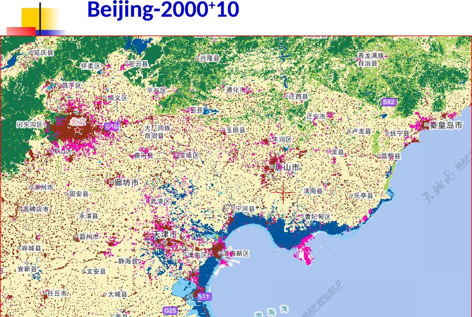
17 Beijing- 2010


18 Beijing- 2000

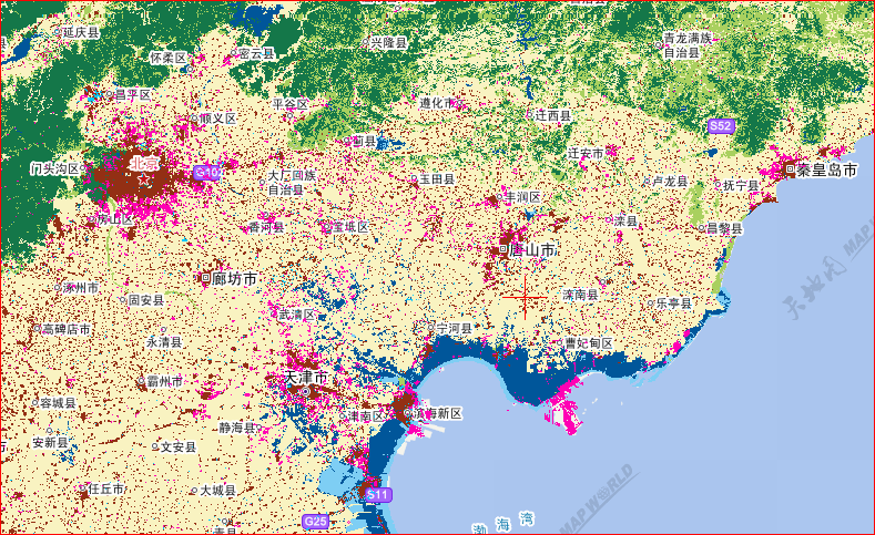
19 Beijing
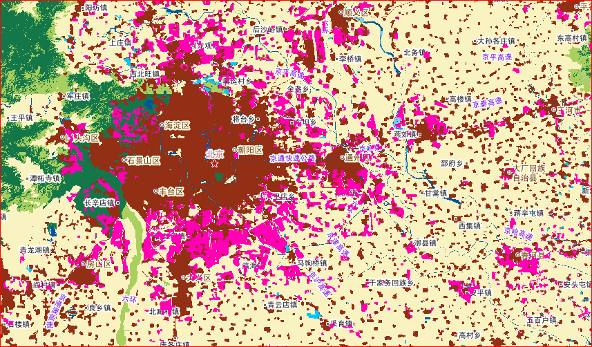
20 Beijing

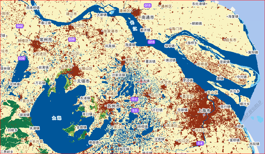
21 Shanghai-2000
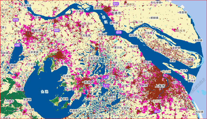
22 Shanghai
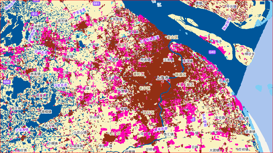
23 Shanghai


24 Accuracy Assessment Map sheets and smapling Map sheets selected: 80 Total samples: 154,070 Region Map smaple sheet s s Asia Europe Africa Americ a Oceani c Total
25 Accuracy Assessment 2010 Class croplands forest grass shrub wetland water artificial bareland Ice User acc % 89.00% 76.88% 72.52% 79.63% 92.09% 86.97% 77.33% Area % % Total accur % ±0.18%
26 Donated to United Nations Sept , New York, donation ceremony of GlobeLand30 UN SG Ban Ki-moon said: The World needs solid, science-based information for making wise decisions for sustainable development. These detailed data sets will help us to better understand, monitor and manage changes in land cover and land use all over our planet
27 On Line Service
28 Nature Published a Letter (514:434, 23 Oct. 2014) China: Open access to Earth land-cover map The map, known as GlobeLand30, comprises data sets collected at 30metreresolution more than ten times that of previous data sets. The GlobeLand30 data sets are freely available and comprise ten types of land cover, including forests, artificial surfaces and wetlands, for the years 2000 and 2010.
29 Downloading- Up to May 25, 2015 南美洲 ; 6% 大洋洲 ; 1% 非洲 ; 8% 北美洲 ; 14% 亚洲 ; 55% More than 5000 users from 90 countries 120, 0,000 map sheets downloaded 欧洲 ; 17% 国家 申请请 次数 请 下请请请 幅 中国 China 美国 USA 加拿大 Canada 蒙古 Mongilia 肯尼 亚 Kenya 意大利 Italy 巴西 Brasil 巴基斯坦 Pakistan 英国 UK 荷 亚 Neitherlands
30 Example of Users Users UN systems NGO GO Research institutes Universities Name of Orgnaisations FAO UNEP UNHabitat UNMIS UNDESA ESCAP UN Unit in Mali UNESCO Islamabad, WWF TNC, The Nature Conservancy) Conservation International, NASA GSFC USGS European Commission, JRC DFZ IIASA INPE Indian Institute of Science Space Research Institute of Ukraine IERSD/NOA, Harvard Yale Un. Maryland Glombia Uni.,
31 Contents Introduction Introduction 4 POK_based operational mapping Data product and service Further works
32 Supporting Post-2015 Agenda and Future Earth Ecolog accounting Dyna monitoring Users Future Earth/Post-2015 Agenda Application Measure Monitoring Manage Big data analysis Geospat statistics Open source software UN Service Platform Service Data Service Push service Processing service Data Supporting GlobeLand30 Servers Standards Refinement Updating Validation Integrating with Socio-economic environmental information
33 Continuous Updating and Refinement ④ Old imagery 1990s 1980 s 1970 s 2015 ② ① 2nd level classification (for certain classes) Change detection New Imagery Higher R. Imagery Globalland Refinement Finer Resol. LC ③(i.e.,10m) Globalland Refinement 2nd level Classes ① ② Globalland ③ Finer resolution (10m) mapping (hot spot areas) ④Historical mapping (backward)
34 Thanks for Your Attention!
Improving global data on forest area & change Global Forest Remote Sensing Survey
 Improving global data on forest area & change Global Forest Remote Sensing Survey work by FAO and partners - Adam Gerrand, E. Lindquist, R. D Annunzio, M. Wilkie, FAO, - F. Achard et al. TREES team at
Global environmental information Examples of EIS Data sets and applications
 METIER Graduate Training Course n 2 Montpellier - february 2007 Information Management in Environmental Sciences Global environmental information Examples of EIS Data sets and applications Global datasets
Outline - needs of land cover - global land cover projects - GLI land cover product. legend. Cooperation with Global Mapping project
 Land Cover Mapping by GLI data Ryutaro Tateishi Center for Environmental Remote Sensing (CEReS) Chiba University E-mail: tateishi@ceres.cr.chiba-u.ac.jp Outline - needs of land cover - global land cover
Review for Introduction to Remote Sensing: Science Concepts and Technology
 Review for Introduction to Remote Sensing: Science Concepts and Technology Ann Johnson Associate Director ann@baremt.com Funded by National Science Foundation Advanced Technological Education program [DUE
Geospatial intelligence and data fusion techniques for sustainable development problems
 Geospatial intelligence and data fusion techniques for sustainable development problems Nataliia Kussul 1,2, Andrii Shelestov 1,2,4, Ruslan Basarab 1,4, Sergii Skakun 1, Olga Kussul 2 and Mykola Lavreniuk
Overview. 1. Types of land dynamics 2. Methods for analyzing multi-temporal remote sensing data:
 Vorlesung Allgemeine Fernerkundung, Prof. Dr. C. Schmullius Change detection and time series analysis Lecture by Martin Herold Wageningen University Geoinformatik & Fernerkundung, Friedrich-Schiller-Universität
Monitoring Overview with a Focus on Land Use Sustainability Metrics
 Monitoring Overview with a Focus on Land Use Sustainability Metrics Canadian Roundtable for Sustainable Crops. Nov 26, 2014 Agriclimate, Geomatics, and Earth Observation Division (ACGEO). Presentation
Global Climate Change: Carbon Reporting Initiative
 United States Agency for International Development Cooperative Agreement No. EEM-A-00-06-00024-00 Global Climate Change: Carbon Reporting Initiative January 2012 Submitted by: Nancy Harris Ecosystem Services
The USGS Landsat Big Data Challenge
 The USGS Landsat Big Data Challenge Brian Sauer Engineering and Development USGS EROS bsauer@usgs.gov U.S. Department of the Interior U.S. Geological Survey USGS EROS and Landsat 2 Data Utility and Exploitation
Land Use/ Land Cover Mapping Initiative for Kansas and the Kansas River Watershed
 Land Use/ Land Cover Mapping Initiative for Kansas and the Kansas River Watershed Kansas Biological Survey Kansas Applied Remote Sensing Program April 2008 Previous Kansas LULC Projects Kansas LULC Map
APPLICATION OF MULTITEMPORAL LANDSAT DATA TO MAP AND MONITOR LAND COVER AND LAND USE CHANGE IN THE CHESAPEAKE BAY WATERSHED
 APPLICATION OF MULTITEMPORAL LANDSAT DATA TO MAP AND MONITOR LAND COVER AND LAND USE CHANGE IN THE CHESAPEAKE BAY WATERSHED S. J. GOETZ Woods Hole Research Center Woods Hole, Massachusetts 054-096 USA
Methods for Monitoring Forest and Land Cover Changes and Unchanged Areas from Long Time Series
 Methods for Monitoring Forest and Land Cover Changes and Unchanged Areas from Long Time Series Project using historical satellite data from SACCESS (Swedish National Satellite Data Archive) for developing
The use of Earth Observation technology to support the implementation of the Ramsar Convention
 Wetlands: water, life, and culture 8th Meeting of the Conference of the Contracting Parties to the Convention on Wetlands (Ramsar, Iran, 1971) Valencia, Spain, 18-26 November 2002 COP8 DOC. 35 Information
Forest Fire Information System (EFFIS): Rapid Damage Assessment
: Rapid Damage Assessment") Forest Fire Information System (EFFIS): Fire Danger D Rating Rapid Damage Assessment G. Amatulli, A. Camia, P. Barbosa, J. San-Miguel-Ayanz OUTLINE 1. Introduction: what is the JRC 2. What is EFFIS 3.
Forest Fire Information System (EFFIS): Fire Danger D Rating Rapid Damage Assessment G. Amatulli, A. Camia, P. Barbosa, J. San-Miguel-Ayanz OUTLINE 1. Introduction: what is the JRC 2. What is EFFIS 3.
Using Location Information For Better Planning and Decision Support: Integrating Big Data, Official Statistics, Geo-information
 Using Location Information For Better Planning and Decision Support: Integrating Big Data, Official Statistics, Geo-information Rapid Information for Public Policy Increasing demand for information in
OBJECT BASED IMAGE CLASSIFICATION AND WEB-MAPPING TECHNIQUES FOR FLOOD DAMAGE ASSESSMENT
 OBJECT BASED IMAGE CLASSIFICATION AND WEB-MAPPING TECHNIQUES FOR FLOOD DAMAGE ASSESSMENT Ejaz Hussain, KyoHyouk Kim, Jie Shan {ehussain, kim458, jshan}@ecn.purdue.edu Geomatics Engineering, School of Civil
Operational Space- Based Crop Mapping Protocols at AAFC A. Davidson, H. McNairn and T. Fisette.
 Operational Space- Based Crop Mapping Protocols at AAFC A. Davidson, H. McNairn and T. Fisette. Science & Technology Branch. Agriculture and Agri-Food Canada. 1. Introduction Space-Based Crop Mapping at
Land Use/Land Cover Map of the Central Facility of ARM in the Southern Great Plains Site Using DOE s Multi-Spectral Thermal Imager Satellite Images
 Land Use/Land Cover Map of the Central Facility of ARM in the Southern Great Plains Site Using DOE s Multi-Spectral Thermal Imager Satellite Images S. E. Báez Cazull Pre-Service Teacher Program University
APPLICATION OF TERRA/ASTER DATA ON AGRICULTURE LAND MAPPING. Genya SAITO*, Naoki ISHITSUKA*, Yoneharu MATANO**, and Masatane KATO***
 APPLICATION OF TERRA/ASTER DATA ON AGRICULTURE LAND MAPPING Genya SAITO*, Naoki ISHITSUKA*, Yoneharu MATANO**, and Masatane KATO*** *National Institute for Agro-Environmental Sciences 3-1-3 Kannondai Tsukuba
Panel Remarks by Mr Mmboneni Muofhe, GEO Principal Alternate, Deputy Director General, Department of Science and Technology, South Africa
 UNGGIM- HLF, 20 22 April 2016, Addis Ababa, Ethiopia Session 1: Land Information for Sustainable Development Sub- Session: Addressing challenges confronting countries 20 April 2016: 15h45 17h00 Panel Remarks
MASS PROCESSING OF REMOTE SENSING DATA FOR ENVIRONMENTAL EVALUATION IN EUROPE
 MASS PROCESSING OF REMOTE SENSING DATA FOR ENVIRONMENTAL EVALUATION IN EUROPE Lic. Adrián González Applications Research Earth Science Conference 2014 29.07.2014 Earth Science San Conference Francisco
Nature Values Screening Using Object-Based Image Analysis of Very High Resolution Remote Sensing Data
 Nature Values Screening Using Object-Based Image Analysis of Very High Resolution Remote Sensing Data Aleksi Räsänen*, Anssi Lensu, Markku Kuitunen Environmental Science and Technology Dept. of Biological
Global land cover mapping: conceptual and historical background
 Space Research Institute Russian Academy of Sciences Global land cover mapping: conceptual and historical background Sergey BARTALEV with acknowledged contribution from: Etienne Bartholomé and Philippe
DETECTING LANDUSE/LANDCOVER CHANGES ALONG THE RING ROAD IN PESHAWAR CITY USING SATELLITE REMOTE SENSING AND GIS TECHNIQUES
 ------------------------------------------------------------------------------------------------------------------------------- Full length Research Paper -------------------------------------------------------------------------------------------------------------------------------
River Flood Damage Assessment using IKONOS images, Segmentation Algorithms & Flood Simulation Models
 River Flood Damage Assessment using IKONOS images, Segmentation Algorithms & Flood Simulation Models Steven M. de Jong & Raymond Sluiter Utrecht University Corné van der Sande Netherlands Earth Observation
Application of Remotely Sensed Data and Technology to Monitor Land Change in Massachusetts
 Application of Remotely Sensed Data and Technology to Monitor Land Change in Massachusetts Sam Blanchard, Nick Bumbarger, Joe Fortier, and Alina Taus Advisor: John Rogan Geography Department, Clark University
Development of Method for LST (Land Surface Temperature) Detection Using Big Data of Landsat TM Images and AWS
 Detection Using Big Data of Landsat TM Images and AWS") Development of Method for LST (Land Surface Temperature) Detection Using Big Data of Landsat TM Images and AWS Myung-Hee Jo¹, Sung Jae Kim², Jin-Ho Lee 3 ¹ Department of Aeronautical Satellite System Engineering,
Development of Method for LST (Land Surface Temperature) Detection Using Big Data of Landsat TM Images and AWS Myung-Hee Jo¹, Sung Jae Kim², Jin-Ho Lee 3 ¹ Department of Aeronautical Satellite System Engineering,
VCS REDD Methodology Module. Methods for monitoring forest cover changes in REDD project activities
 1 VCS REDD Methodology Module Methods for monitoring forest cover changes in REDD project activities Version 1.0 May 2009 I. SCOPE, APPLICABILITY, DATA REQUIREMENT AND OUTPUT PARAMETERS Scope This module
SAMPLE MIDTERM QUESTIONS
 Geography 309 Sample MidTerm Questions Page 1 SAMPLE MIDTERM QUESTIONS Textbook Questions Chapter 1 Questions 4, 5, 6, Chapter 2 Questions 4, 7, 10 Chapter 4 Questions 8, 9 Chapter 10 Questions 1, 4, 7
An Assessment of the Effectiveness of Segmentation Methods on Classification Performance
 An Assessment of the Effectiveness of Segmentation Methods on Classification Performance Merve Yildiz 1, Taskin Kavzoglu 2, Ismail Colkesen 3, Emrehan K. Sahin Gebze Institute of Technology, Department
Innovation and new land monitoring services for climate change, forests and agroforestry
 Innovation and new land monitoring services for climate change, forests and agroforestry Martin Herold Wageningen University Center for Geoinformation Current distribution of aboveground biomass Terrestrial
Sub-pixel mapping: A comparison of techniques
 Sub-pixel mapping: A comparison of techniques Koen C. Mertens, Lieven P.C. Verbeke & Robert R. De Wulf Laboratory of Forest Management and Spatial Information Techniques, Ghent University, 9000 Gent, Belgium
MAPPING MINNEAPOLIS URBAN TREE CANOPY. Why is Tree Canopy Important? Project Background. Mapping Minneapolis Urban Tree Canopy.
 MAPPING MINNEAPOLIS URBAN TREE CANOPY Why is Tree Canopy Important? Trees are an important component of urban environments. In addition to their aesthetic value, trees have significant economic and environmental
Using Remote Sensing Imagery to Evaluate Post-Wildfire Damage in Southern California
 Graham Emde GEOG 3230 Advanced Remote Sensing February 22, 2013 Lab #1 Using Remote Sensing Imagery to Evaluate Post-Wildfire Damage in Southern California Introduction Wildfires are a common disturbance
Forestry Thematic Exploitation Platform Earth Observation Open Science 2.0
 Forestry Thematic Exploitation Platform Earth Observation Open Science 2.0 Tuomas Häme VTT Technical Research of Finland Ltd and the Forestry TEP Team Objective One-stop shop for forestry remote sensing
CIESIN Columbia University
 Conference on Climate Change and Official Statistics Oslo, Norway, 14-16 April 2008 The Role of Spatial Data Infrastructure in Integrating Climate Change Information with a Focus on Monitoring Observed
Understanding image scale and resolution
 Understanding image scale and resolution Ned Horning Version: 1.0 Creation Date: 2004-01-01 Revision Date: 2004-01-01 License: This document is licensed under a Creative Commons Attribution-Share Alike
Course Outline MS Global Environmental Change candidates are required to complete the core module, as well as three compulsory modules:
 ISA Master s Degrees in Sustainability Degree Title Master of Science in Global Environmental Change University King s College University Overview King's College London, ranked among the top 25 universities
Pixel-based and object-oriented change detection analysis using high-resolution imagery
 Pixel-based and object-oriented change detection analysis using high-resolution imagery Institute for Mine-Surveying and Geodesy TU Bergakademie Freiberg D-09599 Freiberg, Germany imgard.niemeyer@tu-freiberg.de
COASTAL MONITORING & OBSERVATIONS LESSON PLAN Do You Have Change?
 Coastal Change Analysis Lesson Plan COASTAL MONITORING & OBSERVATIONS LESSON PLAN Do You Have Change? NOS Topic Coastal Monitoring and Observations Theme Coastal Change Analysis Links to Overview Essays
National Inventory of Landscapes in Sweden
 Key messages Approaching the landscape perspective in monitoring experiences in the Swedish NILS program Johan Svensson, Future Forest Monitoring, 091112 Landscape level approaches are necessary to deal
U.S. Geological Survey Earth Resources Operation Systems (EROS) Data Center
 Data Center") U.S. Geological Survey Earth Resources Operation Systems (EROS) Data Center World Data Center for Remotely Sensed Land Data USGS EROS DATA CENTER Land Remote Sensing from Space: Acquisition to Applications
U.S. Geological Survey Earth Resources Operation Systems (EROS) Data Center World Data Center for Remotely Sensed Land Data USGS EROS DATA CENTER Land Remote Sensing from Space: Acquisition to Applications
Nigerian Satellite Systems, and her Remote Sensing Data
 Nigerian Satellite Systems, and her Remote Sensing Data S. O. Mohammed, PhD (Director-General/Chief Executive) National Space Research & Development Agency (NASRDA) A Presentation at the 2010 International
Advanced Image Management using the Mosaic Dataset
 Esri International User Conference San Diego, California Technical Workshops July 25, 2012 Advanced Image Management using the Mosaic Dataset Vinay Viswambharan, Mike Muller Agenda ArcGIS Image Management
Remote Sensing Method in Implementing REDD+
 Remote Sensing Method in Implementing REDD+ FRIM-FFPRI Research on Development of Carbon Monitoring Methodology for REDD+ in Malaysia Remote Sensing Component Mohd Azahari Faidi, Hamdan Omar, Khali Aziz
The Idiots Guide to GIS and Remote Sensing
 The Idiots Guide to GIS and Remote Sensing 1. Picking the right imagery 1 2. Accessing imagery 1 3. Processing steps 1 a. Geocorrection 2 b. Processing Landsat images layerstacking 4 4. Landcover classification
UK Global Forest Monitoring Network: Forest Carbon Tracking
 UK Global Forest Monitoring Network: Forest Carbon Tracking Andy Shaw Director, Knowledge Exchange, NCEO Head of Strategic Business Development, ISIC GMES/GEO Forum, ISIC, 2011 What is happening to the
Evaluation of Wildfire Duration Time Over Asia using MTSAT and MODIS
 Evaluation of Wildfire Duration Time Over Asia using MTSAT and MODIS Wataru Takeuchi * and Yusuke Matsumura Institute of Industrial Science, University of Tokyo, Japan Ce-504, 6-1, Komaba 4-chome, Meguro,
The premier software for extracting information from geospatial imagery.
 Imagery Becomes Knowledge ENVI The premier software for extracting information from geospatial imagery. ENVI Imagery Becomes Knowledge Geospatial imagery is used more and more across industries because
GMES-DSL GMES - Downstream Service Land: Austria-Slovenia-Andalusia. Concept for a Harmonized Cross-border Land Information System.
 ERA-STAR Regions Project GMES-DSL GMES - Downstream Service Land: Austria-Slovenia-Andalusia. Concept for a Harmonized Cross-border Land Information System Executive Summary submitted by JOANNEUM RESEARCH,
LEOworks - a freeware to teach Remote Sensing in Schools
 LEOworks - a freeware to teach Remote Sensing in Schools Wolfgang Sulzer Institute for Geography and Regional Science University of Graz Heinrichstrasse 36, A-8010 Graz/Austria wolfgang.sulzer@uni-graz.at
Analysis of Land Use/Land Cover Change in Jammu District Using Geospatial Techniques
 Analysis of Land Use/Land Cover Change in Jammu District Using Geospatial Techniques Dr. Anuradha Sharma 1, Davinder Singh 2 1 Head, Department of Geography, University of Jammu, Jammu-180006, India 2
Remote Sensing and Land Use Classification: Supervised vs. Unsupervised Classification Glen Busch
 Remote Sensing and Land Use Classification: Supervised vs. Unsupervised Classification Glen Busch Introduction In this time of large-scale planning and land management on public lands, managers are increasingly
ERP: Willamette-Ecosystem Services Project
 ERP: Willamette-Ecosystem Services Project Presented by Iris Goodman to NAS Sustainability R&D Forum October 17-18, 2007 Conserving ecosystem services through proactive decision-making making Linking Human
7th Framework Programme Theme 6 Environment (including climate change)
") 7th Framework Programme Theme 6 Environment (including climate change) «Environnement» et «Énergie» Programme D. Deybe DG RTD Environment Directorate 1 Cooperation Collaborative Research Ten themes 1.
7th Framework Programme Theme 6 Environment (including climate change) «Environnement» et «Énergie» Programme D. Deybe DG RTD Environment Directorate 1 Cooperation Collaborative Research Ten themes 1.
I.Jonckheere, E. Lindquist & A. Pekkarinen FAO Forestry Department
 Space Data Management System (SDMS) Acquire, Query, Process and Deliver Earth Observation Data and Forest Information Products to Developing Countries Pilot & Project I.Jonckheere, E. Lindquist & A. Pekkarinen
Generation of Cloud-free Imagery Using Landsat-8
 Generation of Cloud-free Imagery Using Landsat-8 Byeonghee Kim 1, Youkyung Han 2, Yonghyun Kim 3, Yongil Kim 4 Department of Civil and Environmental Engineering, Seoul National University (SNU), Seoul,
Satellite Monitoring of Urbanization in Megacities
 Satellite Monitoring of Urbanization in Megacities Yifang Ban Professor of Geoinformatics Department of Urban Planning & Environment KTH Royal Institute of Technology Stockholm, Sweden Introduction In
The Role of Spatial Data in EU Agricultural Policy Analysis
 The Role of Spatial Data in EU Agricultural Policy Analysis Wolfgang Britz Institute for Food and Resource Economics, University Bonn Geospatial Open Source Hosting of Agriculture, Resource and Environmental
Mapping Land Cover Patterns of Gunma Prefecture, Japan, by Using Remote Sensing ABSTRACT
 1 Mapping Land Cover Patterns of Gunma Prefecture, Japan, by Using Remote Sensing Zhaohui Deng, Yohei Sato, Hua Jia Department of Biological and Environmental Engineering, Graduate School of Agricultural
Digital Classification and Mapping of Urban Tree Cover: City of Minneapolis
 Digital Classification and Mapping of Urban Tree Cover: City of Minneapolis FINAL REPORT April 12, 2011 Marvin Bauer, Donald Kilberg, Molly Martin and Zecharya Tagar Remote Sensing and Geospatial Analysis
Mapping Forest-Fire Damage with Envisat
 Mapping Forest-Fire Damage with Envisat Mapping Forest-Fire Damage Federico González-Alonso, S. Merino-de-Miguel, S. García-Gigorro, A. Roldán-Zamarrón & J.M. Cuevas Remote Sensing Laboratory, INIA, Ministry
EO Information Services in support of West Africa Coastal vulnerability - Service Utility Review -
 EO Information Services in support of West Africa Coastal vulnerability - Service Utility Review - Christian Hoffmann, GeoVille World Bank HQ, Washington DC Date : 24 February 2012 Content - Project background
2.3 Spatial Resolution, Pixel Size, and Scale
 Section 2.3 Spatial Resolution, Pixel Size, and Scale Page 39 2.3 Spatial Resolution, Pixel Size, and Scale For some remote sensing instruments, the distance between the target being imaged and the platform,
ENVIRONMENTAL MONITORING Vol. I - Remote Sensing (Satellite) System Technologies - Michael A. Okoye and Greg T. Koeln
 System Technologies - Michael A. Okoye and Greg T. Koeln") REMOTE SENSING (SATELLITE) SYSTEM TECHNOLOGIES Michael A. Okoye and Greg T. Earth Satellite Corporation, Rockville Maryland, USA Keywords: active microwave, advantages of satellite remote sensing, atmospheric
REMOTE SENSING (SATELLITE) SYSTEM TECHNOLOGIES Michael A. Okoye and Greg T. Earth Satellite Corporation, Rockville Maryland, USA Keywords: active microwave, advantages of satellite remote sensing, atmospheric
Land Cover Mapping of the Comoros Islands: Methods and Results. February 2014. ECDD, BCSF & Durrell Lead author: Katie Green
 Land Cover Mapping of the Comoros Islands: Methods and Results February 2014 ECDD, BCSF & Durrell Lead author: Katie Green About the ECDD project The ECDD project was run by Bristol Conservation & Science
2002 URBAN FOREST CANOPY & LAND USE IN PORTLAND S HOLLYWOOD DISTRICT. Final Report. Michael Lackner, B.A. Geography, 2003
 2002 URBAN FOREST CANOPY & LAND USE IN PORTLAND S HOLLYWOOD DISTRICT Final Report by Michael Lackner, B.A. Geography, 2003 February 2004 - page 1 of 17 - TABLE OF CONTENTS Abstract 3 Introduction 4 Study
Land cover mapping in support of LAI and FPAR retrievals from EOS-MODIS and MISR: classification methods and sensitivities to errors
 INT. J. REMOTE SENSING, 2003, VOL. 24, NO. 10, 1997 2016 Land cover mapping in support of LAI and FPAR retrievals from EOS-MODIS and MISR: classification methods and sensitivities to errors A. LOTSCH,
Knowledge-based policy making
 INSPIRE Conference 2011, Edinburgh, 27.06 01.07.2011 1 Knowledge-based policy making Prof. Dr Leen Hordijk Director, Institute for Environment and Sustainability Joint Research Centre European Commission
Remote Sensing in Natural Resources Mapping
 Remote Sensing in Natural Resources Mapping NRS 516, Spring 2016 Overview of Remote Sensing in Natural Resources Mapping What is remote sensing? Why remote sensing? Examples of remote sensing in natural
Science Rationale. Status of Deforestation Measurement. Main points for carbon. Measurement needs. Some Comments Dave Skole
 Science Rationale Status of Deforestation Measurement Some Comments Dave Skole Tropical deforestation is related to: Carbon cycle and biotic emissions/sequestration Ecosystems and biodiversity Water and
RESULT, ANALYSIS AND DISCUSSION
 Chapter 6 RESULT, ANALYSIS AND DISCUSSION As we have already mentioned that our proposed methodology works in two phases, i.e., i) Application development when there is no in the database/application (First
PETROBRAS Orbital Sea Surface Monitoring
 PETROBRAS Orbital Sea Surface Monitoring Performed by : Contingency Control - Exploration & Production Area Technical support: R&D Center Cristina Bentz PETROBRAS R&D Center Environment Assessment and
Developments toward a European Land Monitoring Framework. Geoff Smith. Seminar 2 nd December, 2015 Department of Geography, University of Cambridge
 Developments toward a European Land Monitoring Framework Geoff Smith Specto Natura Limited Enable clients to deliver useful, accurate and reliable environmental information from EO. Positioned at the interface
Landsat Monitoring our Earth s Condition for over 40 years
 Landsat Monitoring our Earth s Condition for over 40 years Thomas Cecere Land Remote Sensing Program USGS ISPRS:Earth Observing Data and Tools for Health Studies Arlington, VA August 28, 2013 U.S. Department
A remote sensing instrument collects information about an object or phenomenon within the
 Satellite Remote Sensing GE 4150- Natural Hazards Some slides taken from Ann Maclean: Introduction to Digital Image Processing Remote Sensing the art, science, and technology of obtaining reliable information
IMAGINES_VALIDATIONSITESNETWORK ISSUE 1.00. EC Proposal Reference N FP7-311766. Name of lead partner for this deliverable: EOLAB
 Date Issued: 26.03.2014 Issue: I1.00 IMPLEMENTING MULTI-SCALE AGRICULTURAL INDICATORS EXPLOITING SENTINELS RECOMMENDATIONS FOR SETTING-UP A NETWORK OF SITES FOR THE VALIDATION OF COPERNICUS GLOBAL LAND
Welcome to NASA Applied Remote Sensing Training (ARSET) Webinar Series
 Webinar Series") Welcome to NASA Applied Remote Sensing Training (ARSET) Webinar Series Introduction to Remote Sensing Data for Water Resources Management Course Dates: October 17, 24, 31 November 7, 14 Time: 8-9 a.m.
Welcome to NASA Applied Remote Sensing Training (ARSET) Webinar Series Introduction to Remote Sensing Data for Water Resources Management Course Dates: October 17, 24, 31 November 7, 14 Time: 8-9 a.m.
TerraColor White Paper
 TerraColor White Paper TerraColor is a simulated true color digital earth imagery product developed by Earthstar Geographics LLC. This product was built from imagery captured by the US Landsat 7 (ETM+)
Asia-Pacific Environmental Innovation Strategy (APEIS)
") Asia-Pacific Environmental Innovation Strategy (APEIS) Integrated Environmental Monitoring IEM) Dust Storm Over-cultivation Desertification Urbanization Floods Deforestation Masataka WATANABE, National
Asia-Pacific Environmental Innovation Strategy (APEIS) Integrated Environmental Monitoring IEM) Dust Storm Over-cultivation Desertification Urbanization Floods Deforestation Masataka WATANABE, National
Using Remote Sensing to Monitor Soil Carbon Sequestration
 Using Remote Sensing to Monitor Soil Carbon Sequestration E. Raymond Hunt, Jr. USDA-ARS Hydrology and Remote Sensing Beltsville Agricultural Research Center Beltsville, Maryland Introduction and Overview
Project Title: Project PI(s) (who is doing the work; contact Project Coordinator (contact information): information):
 (who is doing the work; contact Project Coordinator (contact information): information):") Project Title: Great Northern Landscape Conservation Cooperative Geospatial Data Portal Extension: Implementing a GNLCC Spatial Toolkit and Phenology Server Project PI(s) (who is doing the work; contact
Project Title: Great Northern Landscape Conservation Cooperative Geospatial Data Portal Extension: Implementing a GNLCC Spatial Toolkit and Phenology Server Project PI(s) (who is doing the work; contact
Utilizing space and GIS for effective disaster risk management -ESCAP's practices in Asia and the Pacific
 Utilizing space and GIS for effective disaster risk management -ESCAP's practices in Asia and the Pacific Mr. Keran Wang Chief, Space Applications Section Information and Communications Technology and
SPOT4 (Take 5) first validation and application results
 first validation and application results") SPOT4 (Take 5) first validation and application results O.Hagolle CESBIO/CNES, M.Huc CESBIO/CNRS, M.Kadiri CESBIO/THEIA ; J.Inglada CESBIO/CNES, C. Marais-Sicre CESBIO/CNRS, J.Osman CESBIO/CNES (PhD),
SPOT4 (Take 5) first validation and application results O.Hagolle CESBIO/CNES, M.Huc CESBIO/CNRS, M.Kadiri CESBIO/THEIA ; J.Inglada CESBIO/CNES, C. Marais-Sicre CESBIO/CNRS, J.Osman CESBIO/CNES (PhD),
National and Sub-national Carbon monitoring tools developed at the WHRC
 National and Sub-national Carbon monitoring tools developed at the WHRC Nadine Laporte Woods Hole Research Center A. Baccini, W. Walker, S. Goetz, M. Sun, J. Kellndorfer Kigali, 20 th June 2011 Why measuring
Geographical Information Technology (GIT) courses @ Stellenbosch University. Prof Adriaan van Niekerk
 courses @ Stellenbosch University. Prof Adriaan van Niekerk") Geographical Information Technology (GIT) courses @ Stellenbosch University Prof Adriaan van Niekerk Stellenbosch Outline Overview of GIT training @ SU Programmes Short courses Land cover? Stellenbosch
Geographical Information Technology (GIT) courses @ Stellenbosch University Prof Adriaan van Niekerk Stellenbosch Outline Overview of GIT training @ SU Programmes Short courses Land cover? Stellenbosch
Object-Oriented Approach of Information Extraction from High Resolution Satellite Imagery
 IOSR Journal of Computer Engineering (IOSR-JCE) e-issn: 2278-0661,p-ISSN: 2278-8727, Volume 17, Issue 3, Ver. IV (May Jun. 2015), PP 47-52 www.iosrjournals.org Object-Oriented Approach of Information Extraction
 European Forest Data Centre Biosoil/Biodiversity Forest Type Map 2006 P. Kempeneers, JRC T. Durant F. Sedano, JRC L. Seebach, JRC J. San-Miguel-Ayanz, JRC EC -, IES Land Management and Natural Hazard Unit
Outline. Multitemporal high-resolution image classification
 IGARSS-2011 Vancouver, Canada, July 24-29, 29, 2011 Multitemporal Region-Based Classification of High-Resolution Images by Markov Random Fields and Multiscale Segmentation Gabriele Moser Sebastiano B.
Sudan Institutional Capacity Programme. Food Security Information for Action
 1 Sudan Institutional Capacity Programme Food Security Information for Action SIFIA Satellite coverage evaluation and research for land cover mapping Hot spots test analysis for land cover changes Northern
Resolutions of Remote Sensing
 Resolutions of Remote Sensing 1. Spatial (what area and how detailed) 2. Spectral (what colors bands) 3. Temporal (time of day/season/year) 4. Radiometric (color depth) Spatial Resolution describes how
Emergency Management Service. early warning FLOOD AND FIRE ALERTS. Space
 Emergency Management Service early warning FLOOD AND FIRE ALERTS Space 1 Copernicus at a Glance Copernicus is the European Union s Earth Observation programme: a user-driven space programme under civil
Research On The Classification Of High Resolution Image Based On Object-oriented And Class Rule
 Research On The Classification Of High Resolution Image Based On Object-oriented And Class Rule Li Chaokui a,b, Fang Wen a,b, Dong Xiaojiao a,b a National-Local Joint Engineering Laboratory of Geo-Spatial
Extraction of Satellite Image using Particle Swarm Optimization
 Extraction of Satellite Image using Particle Swarm Optimization Er.Harish Kundra Assistant Professor & Head Rayat Institute of Engineering & IT, Railmajra, Punjab,India. Dr. V.K.Panchal Director, DTRL,DRDO,
Partitioning the Conterminous United States into Mapping Zones for Landsat TM Land Cover Mapping
 Partitioning the Conterminous United States into Mapping Zones for Landsat TM Land Cover Mapping Collin Homer Raytheon, EROS Data Center, Sioux Falls, South Dakota 605-594-2714 homer@usgs.gov Alisa Gallant
TerraSAR-X Applications Guide
 TerraSAR-X Applications Guide Extract: Maritime Monitoring: Oil Spill Detection April 2015 Airbus Defence and Space Geo-Intelligence Programme Line Maritime Monitoring: Oil Spill Detection Issue As the
Istanbul Technical University-Center for Satellite Communications and Remote Sensing (ITU-CSCRS)
") Istanbul Technical University-Center for Satellite Communications and Remote Sensing (ITU-CSCRS) Istanbul Technical University, Center for Satellite Communications and Remote Sensing (ITU-CSCRS) was originally
Istanbul Technical University-Center for Satellite Communications and Remote Sensing (ITU-CSCRS) Istanbul Technical University, Center for Satellite Communications and Remote Sensing (ITU-CSCRS) was originally
Accuracy Assessment of Land Use Land Cover Classification using Google Earth
 American Journal of Environmental Protection 25; 4(4): 9-98 Published online July 2, 25 (http://www.sciencepublishinggroup.com/j/ajep) doi:.648/j.ajep.2544.4 ISSN: 228-568 (Print); ISSN: 228-5699 (Online)
How To Make A Remote Sensing Image Realtime Processing For Disaster Emergency Response
 Remote sensing image real-time processing for rapid disaster emergency response Dr.Haigang Sui LIESMARS, Wuhan University Oct 23, 2013 Outline 1 Major requirements in disaster emergency response 2 Main