Developed by: Charlotte-Mecklenburg Storm Water Services Charlotte-Mecklenburg Storm Water Services Flood Mitigation Program
|
|
|
- Allan Horton
- 8 years ago
- Views:
Transcription
1 FLOODPLAIN REGULATIONS TECHNICAL GUIDANCE DOCUMENT To Prevent Loss of Life, Reduce Property Damage and Protect and Enhance the Natural and Beneficial Functions of Floodplains Developed for: The City of Charlotte and Mecklenburg County Developed by: Charlotte-Mecklenburg Storm Water Services Charlotte-Mecklenburg Storm Water Services Flood Mitigation Program

2 Section Table of Contents Page Section Introduction Floodplain Management Overview Purpose of Technical Guidance Document Process for Amending the Technical Guidance Document... 1 Section Purpose and Background of Floodplain Regulations Purpose of Regulations Local Floodplain Management Jurisdictions Exceeding FEMA Minimum Standards Community Floodplain and Two Floodways Community (Future) Floodplain Two Floodway (Encroachment) Areas Revision History Charlotte Floodplain Regulations Mecklenburg County and Towns Floodplain Regulations...9 Section Floodplain Development Permits Permitting Overview General Floodplain Development Permit General Permit Activity Project Descriptions Individual Floodplain Development Permits Individual vs. General Permit FAQ Permitting Guidance Graphical Examples of Permit Submittal Requirements Application Submission and Review Process Building Permits & Floodplain Review Interpretations by the Floodplain Administrator Individual Floodplain Development Permit Fees Section Specific Development Standards & Activities Standards and Activities Overview Pre-FIRM and Post-FIRM Buildings Improvements/Renovations/Repairs to Floodprone Buildings Substantial Improvement Overview Determining Substantial Improvement Building Improvements Valued Less than 25% Building Improvements Valued Between 25% and 50% Building Improvements Valued Greater than 50% Substantial Improvement Exemptions for Code Violations Community Substantial Improvement Exemption Substantial Improvement FAQ Parking Lot Elevation Requirements Dryland Access i

3 Section Table of Contents (cont.) Page Section Project Completion and Closeout Letters of Map Change (LOMA, LOMR-F) Submittal of Certification of Fill Placement Development Within the Floodplain But Outside of the Community Encroachment Area Submittal of As-Built Plans and Approval Process Elevation Certificates and Occupancy Holds Section Appeals and Variances Overview Zoning Board of Adjustment Variances Appeals Forms, Instructions, Procedures and Fees Section 7 - Violations of the Floodplain Regulations Violation Overview Notification Hearing Corrective Actions Taken Corrective Actions Not Taken Penalties List of Figures Figure 2.1 Municipal Spheres of Influence...4 Figure 3.1 Areas Requiring Flood Studies Under the Individual FDP...15 Figure 3.2 General Floodplain Development Permit Matrix...16 Figure 3.3 Individual Floodplain Development Permit Matrix...18 Figure 3.4 Proposed Development in Community Encroachment Area...20 Figure 3.5 Proposed Development in FEMA Flood Fringe Area...21 Figure 3.6 Proposed Development in Community Encroachment Area...21 Figure 3.7 Proposed Development in FEMA Floodway...22 Figure 3.8 Lines and Areas on Charlotte-Mecklenburg Floodplain Maps...23 Figure 3.9 Floodplain Development Permits and Approval...25 Figure 4.1 Elevated Building.33 Figure 4.2 Floodprone Parking Lot...38 Figure 4.3 Dryland Access Example...39 ii

4 Appendix A Contents Individual Permit Fee Schedule Affidavit of Substantial Improvement Community Exemption Affidavit of Non-Substantial Improvements - Between 25% and 50% of Market Value Owner Affidavit of Building Improvements Certification of Development Outside the Community Encroachment Area iii

5 SECTION INTRODUCTION 1.1 Floodplain Management Overview The responsibility for reducing flood losses is shared by all units of government local, state and federal and the private sector. In order to fulfill this responsibility, land owners and/or professionals planning any Development activity within the Floodplain should have the knowledge and skills to plan, design, and construct their project in compliance with the Floodplain Regulations. For purposes of Floodplain management, Development means any manmade change to improved and unimproved real estate, including, but not limited to, buildings or other structures, mining, dredging, filling, grading, paving, excavating or drilling operations. Good Floodplain management begins with an effective set of regulations that have as their ultimate goal to effectively promote public health, safety, and general welfare and minimize losses to life and property due to flood conditions. This should result in a safe and viable community, while providing for lower flood insurance premiums for policyholders. 1.2 Purpose of Technical Guidance Document The purpose of the Floodplain Technical Guidance Document is to supplement the Floodplain Regulations. This document can be used to help explain the applicability of the provisions of the regulations, specifically the Floodplain Development Permit provisions. Guidance is included on the permitting process and information is provided to help clarify the most common and/or unique requirements. In addition, this document will contain many forms and notices that may be required as part of the permitting process. While any interested person may use this Technical Guidance Document, it is written specifically for individuals planning Development within the Floodplain. This document is not part of the Floodplain Regulations, and shall be solely for illustrative and educational purposes. If there is any discrepancy between the Technical Guidance Document and the Floodplain Regulations, the provisions of the Floodplain Regulations shall control. 1.3 Process for Amending the Technical Guidance Document The Technical Guidance Document may be updated and expanded from time to time, based on changes to the Floodplain Regulations, feedback from applicants, a need to update forms, or a desire to further clarify common compliance issues, etc. The Floodplain Administrator is responsible for all amendments to the Technical Guidance Document. A minimum two (2) week public comment period shall be provided for all 1

6 proposed amendments to this document. Longer comment periods shall be allowed for significant modifications. Notification of proposed amendments shall be made to the general public via and posted on the Charlotte-Mecklenburg Storm Water Services website. The Floodplain Administrator shall maintain an database of past applicants or other persons interested in receiving updates regarding the Floodplain Regulations. The Floodplain Administrator shall carefully consider all comments received during the comment period and modify the proposed amendments as appropriate. Following the completion of modifications, the Floodplain Administrator will present the proposed modifications to the Charlotte-Mecklenburg Storm Water Advisory Committee (SWAC) for their input and final approval. After approval by the SWAC, the amended Technical Guidance Document shall go into effect. The Floodplain Administrator shall use the database to notify the general public. The amended Technical Guidance Document shall be made available on the Charlotte-Mecklenburg Storm Water Services website at 2

7 SECTION PURPOSE AND BACKGROUND OF FLOODPLAIN REGULATIONS 2.1 Purpose of Regulations The purpose of the Floodplain Regulations is to promote public health, safety, and general welfare and to minimize public and private losses due to flood conditions in specific areas by provisions designed to: 1. Restrict or prohibit uses which are dangerous to health, safety and property due to water or erosion hazards or which result in damaging increases in erosion or in flood heights or velocities; 2. Require that uses vulnerable to floods, including facilities which serve such uses, be protected against flood damage at the time of initial construction; 3. Control the alteration of natural Floodplain s, stream channels and natural protective barriers which are involved in the accommodation of flood waters; 4. Control filling, grading, dredging and other Development which may increase erosion or flood damage; and 5. Prevent or regulate the construction of flood barriers which will unnaturally divert flood waters or which may increase flood hazards to other lands. 2.2 Local Floodplain Management Jurisdictions For the purposes of Floodplain Management within Mecklenburg County, there are eight jurisdictions including, Charlotte, Mecklenburg County, Cornelius, Davidson, Huntersville, Matthews, Mint Hill, and Pineville. Each municipality has its own Floodplain Regulations to regulate Floodplain development, which is applicable within its entire sphere of influence. Figure 2-1 shows the municipal spheres of influence to aid in determining which jurisdictions Floodplain Regulations must be followed. 3

8 Figure 2-1 Municipal Spheres of Influence 4

9 2.3 Exceeding FEMA minimum standards The Floodplain Regulations for the City of Charlotte, Mecklenburg County and the six small towns exceed the FEMA minimum Floodplain management standards in order to reduce the vulnerability due to flood events that will occur in the future. Past adoption of these higher standards will reduce the risk of loss of life and decrease the amount of damage in future floods. The existence of these higher standards has also provided for reduced flood insurance premiums for all policy holders in the communities that opt to participate in FEMA s Community Rating System program. The factors considered locally in exceeding FEMA minimum standards may be divided into two groups. The general factors for exceeding the FEMA minimum Floodplain requirements include: Floods may occur that are greater than the 100-year level; Culverts or bridges may become blocked with debris during a flood and cause flooding above the 100-year elevations; and Sediment may accumulate in culverts over time and reduce their carrying capacity. In addition, several of the factors that impact project design, include: Impact that future growth/development will have on flood levels; Access to buildings during a flood that results in water levels above the driveway and/or street level to allow for safer ingress and egress of people and property; and Protecting personal property from flooding by reducing the flood risk to vehicles in new parking lots. Below is a summary of the most significant standards within the Floodplain Regulations which exceed the FEMA minimum. Nearly all these higher standards are described in detail in later sections of the Technical Guidance Document. Wider floodways (FEMA Floodway and Community Encroachment Area); Community (future) Floodplain; 5

10 Dryland Access to Habitable Buildings; Cumulative Substantial Improvement/Damage; Parking lot elevation requirements; Freeboard above the Base Flood Elevation; and Levee Standards. 2.4 Community Floodplain and Two Floodways Community (Future) Floodplain Charlotte-Mecklenburg s Flood Insurance Rate Maps (FIRMS) were the first in the country to show two Floodplain s, the FEMA Floodplain and the Community Floodplain. The FEMA Floodplain is set by the Federal Emergency Management Agency (FEMA) and is used primarily for Flood Insurance Rating purposes. The Community or Ultimate/Future Floodplain is a higher standard that was established within Charlotte- Mecklenburg in the year Continued growth within the County will result in increased storm water runoff to the Floodplain s, especially in large events such as the 100-year flood. The Community Floodplain is primarily used to regulate development activities so they are at less risk to future flooding. The City of Charlotte, Mecklenburg County and each of the six Towns have Floodplain regulations. These regulations place additional restrictions on building or renovations in a Floodplain. Floodplain development regulations apply to both the FEMA Floodplain and the Community Floodplain. Before the adoption of new maps and amended Floodplain Regulations in 2000, two pilot hydrologic and hydraulic studies were performed to evaluate the benefits of a Community Floodplain and a wider floodway. The studies showed the projected impacts of manmade activities on potential flooding in the future. These pilot studies indicated that by continuing to use existing conditions land use (FEMA minimum standard) as the basis for determining runoff and resulting flood heights, the base flood elevations would be under predicted an average of about Two Floodway (Encroachment) Areas FEMA employs a Floodway concept for certain streams mapped in detail to regulate development within a specified distance to the creek centerline. The method employs engineering modeling which sets the location of FEMA Floodway Encroachment Lines on both sides of the stream. Filling is then allowed outside of these FEMA Floodway Encroachment Lines and no fill is allowed within the lines. Theoretically, if all the floodplain (flood fringe) outside of the FEMA Floodway Encroachment Lines is filled in, FEMA s minimum standards indicate that the flood level would increase a maximum of one (1) foot above the Base Flood Elevation. 6

11 However, the above mentioned pilot studies indicated that allowing fill material to be placed in the flood fringe area up to the FEMA floodway line (FEMA minimum standard) could actually increase flood depths in the area by 2.3 instead of FEMA s standard of 1.0 feet. Because of this Charlotte-Mecklenburg decided to map a wider, Community Floodway Encroachment Line. If all the area outside of the Community Floodway Encroachment Line is filled the water surface level would rise about 0.2 (accounting for current water quality buffer regulations). The development of the FEMA and Community Encroachment areas, along with their impacts on development, came after extensive input from developers, engineers, and other interested parties. Some of the issues considered included: The amount of land that could be developed; Water quality benefits; The impacts of current buffer regulations; The resulting water surface elevations; and The resulting widths of the Floodplains. Implementing a more conservative floodway (Community Encroachment Area) for regulating new development, makes development within the Floodplain more restrictive and will reduce the potential loss of life and property due to flooding. Citizens currently living and working in the Floodplain, and those moving into new developments within the Floodplain, will be safer. The more conservative Community Encroachment Area shown on the current maps is an average of 45% wider than the FEMA minimum. The resulting FEMA and Community Encroachment Areas provide a higher level of protection while still allowing development opportunity in and around the Floodplain. 2.5 Revision History The City of Charlotte adopted its initial Floodplain Regulations on August 15, This is also the date that the initial Flood Insurance Rate Maps (FIRMS) became effective. The initial maps were based on studies that were completed by the US Geological Survey in The maps were revised on February 2, This revision involved the combination of the previous Flood Boundary Floodway Maps and the Flood Insurance Rate Maps into one revised set of Flood Insurance Rate Maps. New Roads and road names were also added. Taggert Creek was restudied by the USGS and a revised FIRM panel for the area became effective on January 6,

12 A Countywide restudy was performed for the City of Charlotte, Mecklenburg County and the six small towns beginning in The restudy was conducted by a professional engineering firm, Watershed Concepts, and the US Army Corps of Engineers. Maps for individual watersheds were adopted by local Governing bodies for local regulatory purposes in The maps became effective by FEMA (for flood insurance and other purposes) on February 4, These new FEMA Flood Insurance Rate Maps included updated maps and Flood Insurance Studies for all streams with a drainage area of over one square mile, including the portion of the Catawba River in Mecklenburg County Charlotte Floodplain Regulations The timeline below provides a general chronology of major revisions to the City of Charlotte Floodplain Regulations. December 1972 August October 1999 May 2003 July 2007 Initial Floodplain Regulations to regulate development in and near major streams. Floodplain Regulations revised to recognize new Flood Insurance Rate Maps (FIRMs). Numerous changes including: Revisions to add Future Land Use Map (FLUM) and Community Encroachment Area concepts; Language included adopting new flood maps on a watershed by watershed basis; Cumulative Substantial Improvement added; and Interim Freeboard Requirements. Major changes included: Variance needed for any development in FEMA Floodway or Community Encroachment Area (CEA); Permanent Vehicular Access required if in CEA; Administrative Approval Process; and Two (2) foot Freeboard on Catawba River. Major changes included: Two Types of Floodplain Development Permits; Access to Buildings During Flooding; Parking Lot Elevation Requirements; Levee Requirements; Variance to Development in the Community Encroachment Area; Property Owner Requirements; Permit Time Limits; Flood Increases on Existing Buildings; Floodplain Fill Certification; and 8
 on February 4, 2004.")
13 2.5.2 Mecklenburg County and Towns Floodplain Regulations Mecklenburg County s initial Floodplain Regulations is dated June 1, Most of the small towns also used the Mecklenburg County Floodplain Regulations for several years to regulate development in or near Floodplains in their jurisdiction. Today, each small town has its own Floodplain regulations which in most cases, closely follows the City of Charlotte Floodplain Regulations. However, many of the Floodplain regulations differ from each other in a number of areas. The most recent version of each jurisdiction s Floodplain regulations may be found at the Charlotte-Mecklenburg Storm Water Services website: 9

14 SECTION FLOODPLAIN DEVELOPMENT PERMITS 3.1 Permitting Overview FEMA requires all communities that participate in the National Flood Insurance Program (NFIP) to regulate Development that occurs within the Special Flood Hazard Area (SFHA). FEMA defines Development as any manmade change to improved and unimproved real estate, including, but not limited to, buildings or other structures, mining, dredging, filling, grading, paving, excavating or drilling operations. This definition creates administrative and compliance challenges for communities due to its broad applicability. Very small and insignificant actions within the Floodplain are literally considered Development. Examples include adding mulch to a garden, basic landscaping, farming, installing underground utilities, and installing on-grade walkways. In order to avoid undue hardship within the community, yet remain in compliance with FEMA regulations regarding Floodplain permitting, the Floodplain Administrator may issue a General Floodplain Development Permit. Any Development within the Floodplain that does not meet the requirements of the General Floodplain Development Permit requires an Individual Floodplain Development Permit prior to beginning the work. These two permit types are discussed briefly, with examples, below General Floodplain Development Permit The intent of the General Floodplain Development Permit (GFDP) is to allow uses or activities in the Floodplain which inherently will not increase Base Flood Elevations. A variety of uses will be allowed under a GFDP. A separate permit, paper or digital, is not required for an activity that qualifies for a GFDP. These activities and conditions are approved by right and may take place without prior approval. The one exception are those activities included in item c below which require written notification to the Floodplain Administrator prior to commencement of work. a. General farming, pasture, horticulture, forestry, wildlife sanctuaries, gardens, lawns, landscaping and other similar activities; b. Utility infrastructure (poles, sewer manholes, vent pipes, underground utilities, etc.), sign poles, non-solid fences, and other similar activities; c. On-grade driveways, trails, sidewalks, boardwalks, roads and road maintenance; storm drainage system construction, repairs and maintenance (Major and Minor 10

15 system), and other similar activities. The Floodplain Administrator must be notified in writing, including a project description and sketch plan, prior to commencement of these activities; d. Interior renovations with a value of less than $10,000, to a structure with its Lowest Floor not meeting the requirements of Sections (1) and (2); and e. Interior renovations of any value, to a structure with its Lowest Floor meeting the requirements of Sections (1) and (2) General Permit Activity Project Descriptions This section contains a list of project descriptions for activities that the Floodplain Administrator has determined will inherently not increase the Base Flood Elevations (BFE s), or would result in no Technically Measurable increase in the BFE s. These projects are all approved under the General Floodplain Development Permit. Anyone considering a project in the Floodplain that varies from those described below should contact the Floodplain Administrator and may need to submit an Individual Floodplain Development Permit Application. If the Floodplain Administrator determines such an application should fall under the General Floodplain Development Permit, no permit fee will be charged to the applicant. The Floodplain Administrator must be notified in writing ( is preferable) for all projects listed under item c, prior to commencement of these activities. The Charlotte Floodplain Regulations specifically list the following as possibly being allowed under the General Floodplain Development Permit: General farming, pasture, horticulture, forestry, wildlife sanctuaries, gardens, lawns, landscaping and other similar activities. Utility infrastructure (poles, sewer manholes, vent pipes, underground utilities, etc.), sign poles, non-solid fences, and other similar activities. On-grade driveways, trails, sidewalks, boardwalks, roads and road maintenance; storm drainage system construction, repairs and maintenance (Major & Minor system), and other similar activities. The Floodplain Administrator must be notified in writing, including a project description and sketch plan, prior to commencement of these activities. Interior renovations with a value of less than $10,000, to a structure with its Lowest Floor not meeting the requirements of Section (1),(2). Interior renovations of any value, to a structure with its Lowest Floor meeting the requirements of Section (1),(2). 11
 and (2). 3.1.2 General Permit Activity Project Descriptions This section contains a list of project descriptions for activities that the Floodplain Administrator has determined will inherently")
16 To provide additional guidance on other similar activities that may be considered under the General Floodplain Development Permit, the list below is provided. a) Passive land use activities, typically on-going and routine in nature. General farming that does not involve earthwork that permanently alters the topography. Pasture uses and related operational activities. Horticulture use. Forestry involving planting and removing vegetation for maintenance and management purposes. This should not involve earthwork and/or wholesale clearing and grubbing. Wildlife sanctuaries and related operational activities. Gardening that does not involve earthwork that results in permanently altered topography. Lawns and lawn maintenance activities. Routine maintenance of easement and utility corridors. Landscaping that involves softscaping such as plantings, landscaping beds, and mulching. This should not involve hardscaping that permanently alters the topography such as retaining walls, terraces, and pools. b) Construction activities, typically underground or above ground activities that are not technically measurable in hydraulic modeling. Underground utilities that do not permanently alter the topography. Excess soil from new pipes larger than 2 feet in diameter must be disposed of outside the Floodplain. Sewer vent pipes no larger than 2 feet in diameter. These can not be located within the creek (top-of-bank to top-of -bank). Sewer manholes no larger than 5 feet in diameter and projecting no more than 4 feet tall. These can not be located within the creek (top-of-bank to top-of - bank). Overhead utilities, transmission towers, and standard utility boxes constructed completely on-grade. This may also include clearing/grubbing necessary for installation. These can not be located within the creek (top-of-bank to top-of -bank). Poles for signs, overhead utilities, billboards, and alike that are no larger than 2 feet in diameter. These can not be located within the creek (top-ofbank to top-of -bank). Non-solid fences that do not block the flow of water during a flood event. c) Construction /maintenance activities, typically above ground and known to not increase flood levels. Driveways constructed completely on-grade. This may also include clearing/grubbing necessary for project construction. 12

17 Greenway trails constructed completely on-grade. This may also include clearing/grubbing necessary for project construction. Sidewalks constructed on-grade. This may also include clearing/grubbing necessary for project construction. Boardwalks that are open underneath and do not contain hand rails. This should not involve earthwork that permanently alters the topography. Roads and streets constructed completely on or below grade (if allowed to be constructed below the Community Base Flood Elevation by the City and County Floodplain Regulations). This may also include non-solid guardrails/barriers and clearing/grubbing necessary for project construction. Road widening projects constructed completely on or below grade. This may also include non-solid guardrails/barriers and clearing/grubbing necessary for project construction. Road maintenance involving repaving or patching an existing road. Storm drainage system construction that involves installation of new underground pipes or below grade ditches/swales. Excess soil from new pipes larger than 2 feet in diameter must be disposed of outside the Floodplain. Repairs and maintenance to the Major (FEMA mapped streams) storm drainage system (within the creek banks). This includes planting and removing vegetation, spot repairs that armor/stabilizing the creek banks, and culvert maintenance/cleanouts. Repairs and maintenance to the Minor (creeks and pipes flowing into the FEMA streams) storm drainage system (outside the creek banks). This includes planting and removing vegetation, spot repairs that armor/stabilizing the ditches, and repairing storm sewer outfalls/headwalls. Repair and maintenance (such as armoring, stabilizing, securing, or replacing with similar) of existing infrastructure within the creek banks (such as bridge piers, sewer supports, and storm sewer outfalls/headwalls). This should not involve replacement with larger or additional above ground infrastructure Individual Floodplain Development Permits An Individual Floodplain Development Permit (IFDP) is required for all other projects that do not meet the requirements of a General Floodplain Development Permit. The application and review process for an Individual Floodplain Development Permit is described in Section 3.5 of this document. 3.2 Individual vs. General Permit FAQ This section contains some of the most frequently asked questions regarding the concept of Individual and General Floodplain Development Permits. Q. Who makes the final determination if a project or activity would qualify for a General Floodplain Development Permit? 13
.")
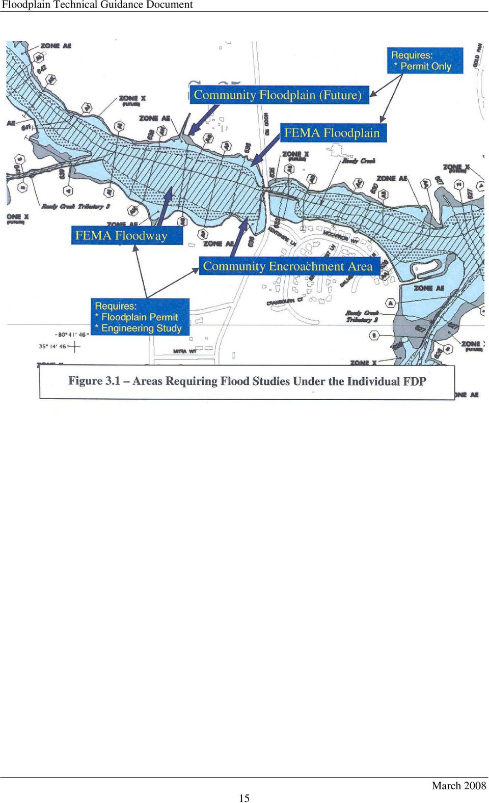
18 A. The Floodplain Administrator. Q. What happens if someone begins an activity that they assume qualifies under a General Floodplain Development Permit but the Floodplain Administrator determines it does not? A. They will be required to stop the activity and apply for and obtain an Individual Floodplain Development Permit. Until the permit is approved, the project is considered a violation of the Floodplain Regulations. Q. Is there an actual paper or digital document issued for a General Floodplain Development Permit? A. No. Q. Would all like activities always qualify for a General Floodplain Development Permit? For example, would all greenway trails automatically qualify for a General Floodplain Development permit? A. No, it is not only the activity or use that must be considered, but also the impact that the proposed activity or use may have on flood elevations. For example, an at grade or excavated trail would have no impact and would qualify for the General Floodplain Development Permit, while a trail that involves significant fill in certain areas would not qualify. Q. Is there a fee for a General Floodplain Development permit? A. No. Q. Will the list of activities and uses that qualify under the General Floodplain Development Permit ever be updated? A. The list may be updated by the Floodplain Administrator based on data and circumstances occurring from previous permitting experience. Q. Why do items listed under item c of the GFDP require written notification to the Floodplain Administrator? A. The Floodplain Administrator must be aware of the activities listed under item c so they may be inspected if desired. 3.3 Permitting Guidance Compliance with the permitting requirements of the Floodplain Regulations is based not only on the type of activity or use but also its location within the various areas of the Floodplain. To aid in determining the submittal and regulatory requirements for Floodplain development under the General and Individual Floodplain Development Permits, several figures are included in this section. Figure 3.1 graphically depicts which areas of the Floodplain will require a flood/engineering study under an Individual Floodplain Development Permit application. The tables in Figures 3.2 and 3.3 summarize the major submittal and regulatory requirements for numerous types of development in various areas within the Floodplain. 14

19 15
20 Figure 3.2 GENERAL FLOODPLAIN DEVELOPMENT PERMIT MATRIX G E N E R A L P E R M I T Floodplain Regulations Section DEVELOPMENT / ACTIVITY (Examples) AREA OF FLOODPLAIN SUBMITTAL REQUIREMENTS FLOODPLAIN IMPACTS 9-62(b) 1.a General farming, pasture, horticulture, forestry, wildlife, sanctuaries, gardens, lawns, landscaping and other similar activities. Any Area of Floodplain None The Activity will result in no Technically Measurable increases on Base Flood Elevations (BFE). Property Owner Notification is not required. 9-62(b) 1.b Utility infrastructure (poles, sewer manholes and vent pipes, etc.), sign poles, non-solid fences, and other similar activities. Any Area of Floodplain None The Activity will result in no Technically Measurable increases on Base Flood Elevations (BFE). Property Owner Notification is not required. 9-62(b) 1.c On-grade improvements such as driveways, trails, boardwalks, sidewalks, roads and road maintenance; storm drainage system improvements, repairs and maintenance (Major & Minor system), and other similar activities. Any Area of Floodplain Letter Notification to the Floodplain Administrator prior to commencement of these activities. The Activity will result in no Technically Measurable increases on Base Flood Elevations (BFE). Property Owner Notification is not required. 16
. Property Owner Notification is not required. 9-62(b) 1.")
21 Figure 3.2 GENERAL FLOODPLAIN DEVELOPMENT PERMIT MATRIX (cont.) G E N E R A L P E R M I T Floodplain Regulations Section DEVELOPMENT / ACTIVITY (Examples) AREA OF FLOODPLAIN SUBMITTAL REQUIREMENTS FLOODPLAIN IMPACTS 9-62(b) 1.d Interior renovations valued less than $10,000 to a noncompliant structure Any Area of Floodplain Supply construction cost estimate with Building Permit Application The Activity will result in no Technically Measurable increases on Base Flood Elevations (BFE). Property Owner Notification is not required. 9-62(b) 1.e Interior renovations of any value to a compliant structure Any Area of Floodplain None The Activity will result in no Technically Measurable increases on Base Flood Elevations (BFE). Property Owner Notification is not required. Notes: 1) The table above is to be used for illustrative purposes only. If there is any discrepancy between information shown in the table and the Floodplain Regulations, the Floodplain Regulations will apply. 2) If a proposed activity is covered within more than one of the layers, then the more stringent requirements will apply. 17
22 Figure 3.3- INDIVIDUAL FLOODPLAIN DEVELOPMENT PERMIT MATRIX I N D I V I D U A L P E R M I T S Section 9-62(b) (2). DEVELOPMENT / ACTIVITY Interior renovations valued greater than $10,000 to a noncompliant structure AREA of FLOODPLAIN Any area of Floodplain SUBMITTAL REQUIREMENTS Individual Floodplain Development Permit (IFDP) Application Owner Affidavit with total construction cost FLOODPLAIN IMPACTS REGULATORY REQUIREMENTS None Applicable requirements of Sections and (b) 2. Any Development and corresponding Floodplain Impacts not described under the General Permit Within the Community Flood Fringe Area IFDP Application Final Construction Plans Documentation on Applicable Check sheet Not Applicable Applicable requirements of Sections and (b) 2. and (6)(a) Any Development and corresponding Floodplain Impacts not described under the General Permit Within the Community Encroachment Area but outside of the FEMA Floodway All Above Submittal Requirements Apply Flood Impact Assessment Using the Community Discharges No-rise (<0.00 ) in Community BFE Increase of <0.10 in Community BFE All Above Regulatory Requirements Apply All Above Regulatory Requirements Apply Notification of the impacted property owner(s) Variance required for increases on Habitable buildings Increase of >0.10 in Community BFE All Above Regulatory Requirements Apply Variance required Notification of the impacted property owner(s) Community CLOMR Post-project Community LOMR 18
23 Floodplain Technical Guidance Document Figure 3.3- INDIVIDUAL FLOODPLAIN DEVELOPMENT PERMIT MATRIX (cont.) I N D I V I D U A L P E R M I T S Section DEVELOPMENT / ACTIVITY AREA of FLOODPLAIN SUBMITTAL REQUIREMENTS FLOODPLAIN IMPACTS REGULATORY REQUIREMENTS 9-62(b) 2. and (6)(b) Any Development and corresponding Floodplain Impacts not described under the General Permit Within the FEMA Floodway All Above Submittal Requirements Apply Flood Impact Assessment Using the FEMA and Community Discharges No-rise (< 0.00 ) in FEMA and Community BFE Rise (> 0.00 ) in FEMA or Community BFE All Above Regulatory Requirements Apply All Above Regulatory Requirements Apply Variance required for increases to the Community BFE on Habitable buildings Notification of the impacted property owner(s) CLOMR and/or Community CLOMR Post-project LOMR and/or Community LOMR Notes: 1) The table above is to be used for illustrative purposes only. If there is any discrepancy between information shown in the table and the Floodplain Regulations, the Floodplain Regulations will apply. 2) If a proposed activity is covered within more than one of the layers, then the more stringent requirements will apply. 3) CLOMR is a Conditional Letter of Map Revision. FEMA s comments on whether a project, if built as proposed, would meet the minimum NFIP standards. 4) Community CLOMR is a letter from the Floodplain Administrator that provides conditional approval of a study that proposes to change the location of the Community Encroachment Lines and/or Community Base Flood Elevations. 19
24 3.4 Graphical Examples of Permit Submittal Requirements This section shows four examples (Figures 3-4 through 3-7) representing typical development scenarios that may occur in the Floodplain. The scenarios depict any type of development (building, fill, etc) and its location with respect to the various Floodplain areas on the Charlotte-Mecklenburg Floodplain maps. Below each example is a list of the permitting requirements for that scenario. Flood Study Required If No-rise in Community BFE, As-built survey required If rise in Community BFE, Community CLOMR & LOMR required Elevation Certificate required prior to Issuance of Certificate of Occupancy Figure 3.4 Proposed Development in Community Encroachment Area 20
25 Flood Study not required Certification of fill placement required after construction Elevation Certificate required prior to Issuance of Certificate of Occupancy Figure 3.5 Proposed Development in the FEMA Flood Fringe Area Flood Study Required Must show no-rise only in Community BFE Elevation Certificate required prior to Issuance of Certificate of Occupancy As-built survey required after construction Figure 3.6 Proposed Development in the Community Encroachment Area 21
26 Flood Study Required Must show no-rise in FEMA & Community BFE Elevation Certificate required prior to Issuance of Certificate of Occupancy As-built survey required after construction Figure 3.7 Proposed Development in the FEMA Floodway 3.5 Application Submission and Review Process An Individual Floodplain Development Permit is required for all grading or development in the Floodplain or on lots that touch the Floodplain that do not meet the conditions in the General Permit. To determine if a proposed development or lot is touching the community flood fringe, please check with the Floodplain Administrator or check the Floodzone Interactive Map on the Charlotte-Mecklenburg Storm Water Services website at Regulations for an Individual Floodplain Development Permit vary greatly depending on the type of development (TYPE) and where development is located in the Floodplain (AREA). Figure 3-8 shows the Floodplain areas and lines as defined in the Floodplain Regulations. It also attempts to convey the layering effect of the various Floodplain areas in relation to each other. 22
27 Figure 3.8 Lines and Areas on Charlotte-Mecklenburg Floodplain Maps Along with the permit application, the submittal must include the CHECK SHEET(S) for the TYPE/AREA of Development Activity listed on the Application, and the required supporting documentation. There are Check Sheets for the following: Substantial Improvement Check Sheet - use for Improvements to Existing Structures in the Floodplain for TYPE/AREA 2A, 2B, 2C Floodplain Development Check Sheet - use for development in the flood fringe for TYPE/AREA 3C Floodway Development Check Sheet - use for development in the floodway for TYPE/AREA 1A, 1B, 3A, & 3B If your TYPE of development is not listed, a Check Sheet is not required to be attached to the permit application. For the purpose of Floodplain review and approval, the three type(s) of development are as follows: 23
28 Type 1 - New Structure/Building Type 2 - Improvement of Existing Structure/Building Type 3 - Other Development Activity (Mining, Dredging, Filling, Grading, Excavating, Drilling, Etc.) These Development activities can be proposed in several areas in and around the Floodplain. For Floodplain Management purposes, the locations/areas of development are as follows: Area A - Within FEMA Floodway Area B - Within Community Encroachment Area Area C Within the Community Flood Fringe Area The applicant should select all types and all the areas where the proposed development is planned. If your project involves unique circumstances that are not covered by the TYPE/AREA(s) listed on the Individual Floodplain Development Permit Application, you should contact the Permit Coordinator or Floodplain Administrator for assistance. Mecklenburg County uses a "Permit Coordinator Process" to ensure efficient and effective review of all Individual Floodplain Development Permit Applications. The applicant should submit the permit application, along with all applicable Check Sheet(s), and other supporting documentation, to the Permit Coordinator in person or through the mail at the following location: Mecklenburg County Flood Mitigation Program 700 N. Tryon Street Charlotte, NC Attn: Floodplain Permit Coordinator The most common problem with permit applications is that they are incomplete. Appropriate Check Sheet(s) should be thoroughly reviewed and all the information listed should be included. Applications do not get forwarded to the technical review staff until they contain all the information needed for review. Figure 3-9 shows the review and approval process for all development activities that require a submittal to the Charlotte- Mecklenburg Storm Water Services Flood Mitigation Program. 24
29 Figure Floodplain Permits - Review & Approval Process General FDP Activities Proposed activities as described in Section (b) (1) (c) of the Floodplain Regs. Individual FDP Activities Proposed Development within the Floodplain not covered under the General FDP Written Notification Project description Sketch plan Individual FDP Application Package Permit Coordinator Review Completeness review Permit Fee calculation 1 4 business days* Letter to Applicant Acknowledged as Complete OR Additional Info. Required 90 calendar days** Technical Review Engineering review Floodplain Regulations compliance review Not Approved Letter to Applicant Additional Info. Required 90 calendar days** Floodplain Administrator Review Final Review IFD Issuance/GFDP Approval 1 business day* Approved Individual Floodplain Development Permit 2 years** *Estimated review turn-around times. Actual review time may be shorter or longer depending on complexity, and other unforeseen circumstances. **Application or Permit expiration period 25
30 Upon receipt of the Individual Floodplain Development Permit Application, the Permit Coordinator will review the application for completeness and compute the permit fee (if applicable). The applicant will receive either an Additional Information "ADD" Letter (if the application package is incomplete and cannot be reviewed), OR an Acknowledgement ACK Letter (if the application is complete and will begin the technical review). All correspondence/letters are generally sent via and/or telephone. addresses should be included on the application along with other contact information such as phone and fax numbers. Once the Permit Coordinator determines that the permit submittal includes all the necessary information, the Technical Review Staff will begin the review for compliance with the applicable Floodplain Regulations. The applicant will receive either an Additional Information "ADD" Letter (requiring additional or corrected information), OR an approved Individual Floodplain Development Permit. Due to the wide variation in the complexity of the submittal reviews, the review times will vary. The anticipated review times for each type of submittal are listed at the bottom of each Check Sheet. If the application is approved, the Floodplain Administrator or Authorized Designee will issue the Permit and send it to the applicant. Applicants should review the Terms & Conditions listed on the Permit. The following conditions apply to all Floodplain Development Permits. 1. The Floodplain Development Permit applies to the parcel(s) of land listed on the application; 2. The Floodplain Development Permit does not change the Flood Insurance Rate Map (FIRM) Floodplain and/or floodway lines; 3. Permitee must obtain all other permits required for construction; 4. The Floodplain Development Permit expires when/if the current Effective Flood Insurance Rate Map (FIRM) applicable to the project is revised or updated; 5. The Floodplain Development Permit expires within two years unless substantial work begins, or a written extension is granted by the Floodplain Administrator; and 6. If development activities do not commence within 30 days of the Date of Issuance, the permitee must notify the Floodplain Administrator or Authorized Designee (in writing) prior to beginning any work. 3.6 Building Permits & Floodplain Review Many projects reviewed by the Charlotte-Mecklenburg Storm Water Services Flood Mitigation Program permitting staff involve the construction of new buildings within or near the Floodplain. Any new building built on a lot that touches the Floodplain will automatically be reviewed for compliance with the Floodplain Regulations as part of the Building Permitting process. In most cases, additional information is not necessary and the building permit will not be delayed from being issued. In other cases, a separate 26
31 Individual Floodplain Development Permit is necessary to ensure compliance with the Floodplain Regulations. The typical steps for permitting a building within or near the Floodplain are listed below. 1. Apply for a building permit from Mecklenburg County Code Enforcement; 2. Permit and Occupancy Hold are automatically placed if the lot touches the Floodplain; 3. Charlotte-Mecklenburg Storm Water Services Flood Mitigation staff reviews the Building Permit Application and will either a) remove the Permit Hold (example, if the proposed building or improvement is far from the floodplain), or b) require additional information, (if it is unclear of the building/improvement location in relation to the floodplain, or c) require additional information along with an Individual Floodplain Development Permit application and Permit Fee (for example, proposed improvements to a building are over $10,000 in value, therefore a IFDP is required).; 4. After reviewing additional information (if necessary) the Charlotte-Mecklenburg Storm Water Services Flood Mitigation Program staff may issue an Individual Floodplain Development Permit and would then release the Building Permit Hold; and 5. Most buildings will still have a Floodplain Occupancy Hold that will only be removed upon submittal and review of an approved FEMA Elevation Certificate. The Elevation Certificate is available at Interpretations by the Floodplain Administrator The Floodplain Administrator may need to make an interpretation of any provision within the Floodplain Regulations from time to time. Interpretations or guidance are usually issued under unique and unusual circumstances. Any interpretation or guidance that is not project-specific and may affect future applicants will be published in the Floodplain Regulations Interpretations Document. Any interpretation made by the Floodplain Administrator pursuant to or regarding the Floodplain Regulations, may be appealed to the Zoning Board of Adjustment by the aggrieved party. 3.8 Individual Floodplain Development Permit Fees Individual Floodplain Development Permit Applications are subject to a permit fee for services associated with reviewing the proposed project for compliance with Floodplain Regulations. The Fee Schedule is included in Appendix A. Also included in Appendix A is the Individual FDP Fee Calculator Reference Guide. This guide provides a method to view the required fees in a matrix which shows the most common activities and the area of the Floodplain the activity occurs within. 27
32 Projects meeting the criteria of the General Floodplain Development Permit will not be charged a fee. Projects owned and funded by local governments within Mecklenburg County are exempt from Fee Charges. The Individual Floodplain Development Permit Fee Charges are based on the average review time and are categorized based on the following factors: Type of proposed development activities; Location of development activities within the Floodplain ; and Whether the proposed development activities are located on one or more parcels. Applicants may attempt to compute the fee and submit it along with the initial Individual Floodplain Development Permit Application. Upon initial review for completeness, the Permit Coordinator will compute the Permit Fee and notify the applicant of the total fee before the plans are sent to the technical reviewer. All Individual Floodplain Development Permit Fees should be paid once the application is deemed complete and prior to the County beginning the technical review. All Individual Floodplain Development Permit Fees must be paid in full prior to issuance of the Floodplain Development Permit. A permit will not be issued until the Permit Fee is received by the County. FEE Appeals will be heard by the Director of Mecklenburg County Storm Water Services. Development activities sometimes occur prior to issuance of a permit. In many cases these are treated as violations to the Floodplain Regulations and must be quickly brought into compliance. Violation corrections typically take twice the staff time of a normal review, therefore the fees are higher than the normal Permit Fee. They are not meant to be punitive in nature. Individual Floodplain Development Permit fees may be paid via cash, check, or charged to an existing account in Land Use and Environmental Services (LUESA). To pay by cash or check: Confirm payment amount with Floodplain Permit Coordinator; Make check payable to Mecklenburg County; and Deliver payment to the Floodplain Permit Coordinator located at 700 N. Tryon Street, Charlotte, NC To charge to existing LUESA account: Make sure you have an active account with LUESA; and Provide written authorization (via letter or ) to charge against your account to Floodplain Permit Coordinator. 28
Floodplain Development Land Use Review
 COMMUNITY DEVELOPMENT DEPARTMENT Planning Division P.O. Box 490 333 Broadalbin Street SW Albany, OR 97321 Phone 541-917-7550 Fax 541-791-0150 www.cityofalbany.net Floodplain Development Land Use Review
CASS COUNTY COMMISSION POLICY MANUAL 38.07 ADOPTED DATE: FEBRUARY 2, 1998 PAGE 1 OF 9
 CASS COUNTY COMMISSION POLICY MANUAL 38.07 SUBJECT: ORDINANCE #1998-2 (FLOOD DAMAGE PREVENTION) ADOPTED DATE: FEBRUARY 2, 1998 PAGE 1 OF 9 NORTH DAKOTA COUNTY OF CASS ORDINANCE #1998-2 Be it ordained and
Frequently-Asked Questions about Floodplains and Flood Insurance FLOOD INSURANCE
 Frequently-Asked Questions about Floodplains and Flood Insurance What is a floodplain? The floodplain is any area covered by water during normal water flows, and which could be inundated as a result of
SECTION 1.0 STATUTORY AUTHORIZATION AND PURPOSE
 A local law for Flood Damage Prevention as authorized by the New York State Constitution, Article IX, Section 2, and Environmental Conservation Law, Article 36 1.1 FINDINGS SECTION 1.0 STATUTORY AUTHORIZATION
The answers to some of the following questions are separated into two major categories:
 Following the recent flooding events for Front Range communities in Colorado, property owners, communities, and the National Flood Insurance Program are being presented with some new challenges in the
CHAPTER 3 page 69 LOCAL FLOODPLAIN REGULATIONS AND NFIP STANDARDS
 CHAPTER 3 page 69 LOCAL FLOODPLAIN REGULATIONS AND NFIP STANDARDS LOCAL FLOODPLAIN REGULATIONS AND NFIP STANDARDS, page 69 THE PARTICIPATION OF A COMMUNITY IN THE NFIP IS MADE POSSIBLE BY ITS ADOPTION
Kentucky Model Flood Damage Prevention Ordinance. 2015 KAMM Annual Conference Carey Johnson Kentucky Division of Water
 Kentucky Model Flood Damage Prevention Ordinance 2015 KAMM Annual Conference Carey Johnson Kentucky Division of Water Flood Damage Prevention Ordinance Also referred to as Floodplain Management Ordinance
Teller County, Colorado Floodplain Development Permit Application
 Teller County, Colorado Floodplain Development Permit Application This is an application packet for a Floodplain Development Permit (FDP). Certain sections are to be completed by the Applicant, and certain
UNIT 5: THE NFIP FLOODPLAIN MANAGEMENT REQUIREMENTS
 UNIT 5: THE NFIP FLOODPLAIN MANAGEMENT REQUIREMENTS In this unit This unit reviews the NFIP standards for floodplain development, including: What maps, base flood elevations and other flood data must be
OKANOGAN COUNTY OFFICE OF PLANNING AND DEVELOPMENT FLOODPLAIN DEVELOPMENT PERMIT APPLICATION
 OKANOGAN COUNTY OFFICE OF PLANNING AND DEVELOPMENT FLOODPLAIN DEVELOPMENT PERMIT APPLICATION Okanogan County Code, OCC 15.08, Floodplain Management The State of Washington has authorized county governments
rescue and relief efforts in the aftermath of flooding, (iii) repair of flood damaged public facilities and utilities, and
 repair of flood damaged public facilities and utilities, and") 1. Purpose (1) It is the purpose of this Ordinance to protect human life, health, and property from flood conditions, to preserve the ability of floodplains to carry and discharge a base flood, and to
1. Purpose (1) It is the purpose of this Ordinance to protect human life, health, and property from flood conditions, to preserve the ability of floodplains to carry and discharge a base flood, and to
Lincoln County Floodplain Development Permit Application
 Lincoln County Floodplain Development Permit Application Application # FP Use Permit Variance Appeal Date SECTION I: GENERAL PROVISIONS (APPLICANT to read and sign) 1. No work of any kind may start until
CITY OF NORTHWEST FLOOD DAMAGE PREVENTION ORDINANCE. Non-Coastal Regular Phase
 CITY OF NORTHWEST FLOOD DAMAGE PREVENTION ORDINANCE Non-Coastal Regular Phase ARTICLE 1. STATUTORY AUTHORIZATION, FINDINGS OF FACT, PURPOSE AND OBJECTIVES. SECTION A. STTUTORY AUTHORIZATION. Municipal:
PREVENTION. City of Orem FLOOD DAMAGE PREVENTION 10-1-1
 City of Orem FLOOD DAMAGE PREVENTION 10-1-1 CHAPTER 10. Article 10-1. Article 10-2. Article 10-3. Article 10-4. Article 10-5. FLOOD DAMAGE PREVENTION Purposes Definitions General Provisions Administration
TITLE XV: LAND USAGE 150. BUILDING CODE 151. FLOOD DAMAGE PREVENTION 153. SUBDIVISION REGULATIONS 154. ZONING CODE
 TITLE XV: LAND USAGE Chapter 150. BUILDING CODE 151. FLOOD DAMAGE PREVENTION 152. MOBILE HOMES AND TRAILER PARKS 153. SUBDIVISION REGULATIONS 154. ZONING CODE 2001 S-7 1 2 Middletown - Land Usage CHAPTER
CITY OF MIDDLETOWN, OHIO FLOOD DAMAGE PREVENTION REGULATIONS
 CITY OF MIDDLETOWN, OHIO FLOOD DAMAGE PREVENTION REGULATIONS October 2010 TABLE OF CONTENTS SECTION General Provisions Introduction... 1 Statement of Purpose... 1 Methods of Reducing Flood Loss... 1-2
Control filling, grading, dredging, and other development which may increase erosion or flood damage; and
 ARTICLE 16. FLOOD DAMAGE PREVENTION Section 16-1: Findings of Fact The flood hazard areas of the Town of Lillington are subject to periodic inundation which results in loss of life and property, health
SPECIAL PURPOSE FLOOD DAMAGE REDUCTION RESOLUTION MUSKINGUM COUNTY, OHIO
 SPECIAL PURPOSE FLOOD DAMAGE REDUCTION RESOLUTION MUSKINGUM COUNTY, OHIO SECTION 1.0: GENERAL PROVISIONS 1.1 Statutory Authorization This resolution is adopted pursuant to authorization contained in Sections
Administrative Procedures Regarding the Application of Flood Damage Prevention
 Administrative Procedures Regarding the Application of Flood Damage Prevention A floodplain development permit, conforming to the provisions of the Flood Damage Prevention Ordinance ( the Ordinance, shall
SECTION 15 FLOODPLAIN MANAGEMENT
 SECTION 15 15.1 Purpose Certain areas of the City of Gardiner, Maine, are subject to periodic flooding, causing serious damages to properties within these areas. Relief is available in the form of flood
SPECIAL PURPOSE FLOOD DAMAGE REDUCTION RESOLUTION BELMONT COUNTY, OHIO
 SECTION 1.0: GENERAL PROVISIONS SPECIAL PURPOSE FLOOD DAMAGE REDUCTION RESOLUTION BELMONT COUNTY, OHIO 1.1 Statutory Authorization This resolution is adopted pursuant to authorization contained in Sections
RESPONSE TO COMMENTS AND SUGGESTIONS 2013 MODEL REGUATIONS September 3, 2013 version Montana Department of Natural Resources and Conservation
 RESPONSE TO COMMENTS AND SUGGESTIONS 2013 MODEL REGUATIONS September 3, 2013 version Montana Department of Natural Resources and Conservation February 24, 2013 A comment was to use consistently, either
TITLE 8 FLOOD DAMAGE PREVENTION
 Henry County Development Code Flood Damage Prevention TITLE 8 FLOOD DAMAGE PREVENTION SECTION 1.0 FLOOD DAMAGE PREVENTION: STATUTORY AUTHORIZATION The Indiana Legislature granted the power to local units
FLOOD DAMAGE PREVENTION ORDINANCE
 FLOOD DAMAGE PREVENTION ORDINANCE SECTION 1.0 STATUTORY AUTHORIZATION, FINDINGS FO FACT, PURPOSE, AND OBJECTIVES 1.1 STATUTORY AUTHORIZATION The Legislature of the State of Washington has in RCW delegated
Division of Water Frequently asked floodplain questions
 Division of Water Frequently asked floodplain questions Q: Where can I find copies of the floodplain mapping? A: Local floodplain administrators will have copies of the FEMA mapping. (Generally the local
OWNERS NAME PHONE OWNERS ADDRESS APPLICANTS NAME PHONE APPLICANTS ADDRESS
 TOWN OF SWANSBORO 502 Church Street, Swansboro, NC 28584 FLOODPLAIN DEVELOPMENT PERMIT OWNERS NAME PHONE OWNERS ADDRESS APPLICANTS NAME PHONE APPLICANTS ADDRESS Per Article 21, Section 21-7. Establishment
ORDINANCE NO. 2013 -
 ORDINANCE NO. 2013 - AN ORDINANCE OF BREVARD COUNTY, FLORIDA AMENDING CHAPTER 62, LAND DEVELOPMENT REGULATIONS SECTION 62-2891, LOT DRAINAGE, AND CHAPTER 22 BUILDINGS AND BUILDING REGULATIONS, SECTION
City of Valdosta Land Development Regulations. Table of Contents
 TITLE 1 ADMINISTRATION Chapter 102 General Provisions 102-1 Title 102-2 Purpose 102-3 Authority 102-4 Jurisdiction 102-5 Application of Ordinance 102-6 Relationship to Existing Ordinances 102-7 Powers
Flood Protection in Garland Past, Present, and Future. Presented by: R. Lyle Jenkins, P.E., CFM City of Garland, Texas
 Flood Protection in Garland Past, Present, and Future Presented by: R. Lyle Jenkins, P.E., CFM City of Garland, Texas A few facts about Garland: Originally incorporated in 1891 Population 226,876 (2010
COMMUNITY CERTIFICATIONS
 National Flood Insurance Program Community Rating System COMMUNITY CERTIFICATIONS Public reporting burden for this form is estimated to average 4 hours for annual recertification, per response. The burden
EXISTING STRUCTURES 1) FAIR MARKET VALUE OF STRUCTURE(s) BEFORE IMPROVEMENT: 2) COST OF IMPROVEMENTS:
 FAIR MARKET VALUE OF STRUCTURE(s) BEFORE IMPROVEMENT: 2) COST OF IMPROVEMENTS:") Date Received: Received By: Project/Permit Number: Fee: (To be Completed by MOA) FLOOD HAZARD PERMIT APPLICATION (Please fill out application completely; Indicate NA if necessary. Property information
Date Received: Received By: Project/Permit Number: Fee: (To be Completed by MOA) FLOOD HAZARD PERMIT APPLICATION (Please fill out application completely; Indicate NA if necessary. Property information
ARTICLE 12 FLOOD DAMAGE PREVENTION
 ARTICLE 12 FLOOD DAMAGE PREVENTION SECTION 12.1 AUTHORIZATION 12.1.1 General The Legislature of the State of North Carolina has in Part 6, Article 21 of Chapter 143; Parts 3 and 4 of Article 18 of Chapter
Permits for Development within Floodplains
 For More Information OKLAHOMA Oklahoma Water Resources Board 3800 N. Classen Boulevard Oklahoma City, OK 73118 (405) 530-8800 www.owrb.ok.gov Bulletin No. 2 FLOODPLAIN MANAGEMENT INFORMATION SERIES Lawton
Adopted 9/23/98 CHATTAHOOCHEE CORRIDOR PLAN. The goals of the Chattahoochee Corridor Plan (hereinafter also referred to as the Plan ) are:
 are:") CHATTAHOOCHEE CORRIDOR PLAN Adopted 9/23/98 PART 1: GOALS. POLICY. COVERAGE. A. Goals The goals of the Chattahoochee Corridor Plan (hereinafter also referred to as the Plan ) are: 1. Preservation and protection
CHATTAHOOCHEE CORRIDOR PLAN Adopted 9/23/98 PART 1: GOALS. POLICY. COVERAGE. A. Goals The goals of the Chattahoochee Corridor Plan (hereinafter also referred to as the Plan ) are: 1. Preservation and protection
Title 12. Teton County, Idaho Flood Damage Prevention Ordinance
 Title 12 Teton County, Idaho Flood Damage Prevention Ordinance I. STATUTORY AUTHORIZATION, FINDINGS OF FACT, PURPOSE, AND OBJECTIVES 1 A. Statutory Authority 1 B. Findings of Fact 1 C. Statement of Purpose
ALAMANCE COUNTY FLOOD DAMAGE PREVENTION ORDINANCE
 ALAMANCE COUNTY FLOOD DAMAGE PREVENTION ORDINANCE Originally adopted by THE BOARD OF COUNTY COMMISSIONERS August 15, 1994 FLOOD DAMAGE PREVENTION ORDINANCE Table of Contents ARTICLE 1. STATUTORY AUTHORIZATION,
Sample Flood Damage Prevention Ordinance
 Sample Flood Damage Prevention Ordinance COUNTY OF RABUN STATE OF GEORGIA ORDINANCE AN ORDINANCE ADOPTING FLOOD DAMAGE PREVENTION REGULATIONS OF THE CITY OF CLAYTON, GEORGIA WHEREAS; The Mayor and City
ARTICLE I. STATUTORY AUTHORIZATION, FINDINGS OF FACT, PURPOSE AND OBJECTIVES
 Chapter 9 FLOOD DAMAGE PREVENTION* *Editor's note: Articles 1--6 of an ordinance adopted May 4, 2009, is being treated as superseding the provisions adopted May 20, 2002 from which Ch. 9, 9-1--9-15, 9-31--9-35,
CHAPTER XXII FLOOD DAMAGE PREVENTION
 CHAPTER XXII FLOOD DAMAGE PREVENTION 22-1 PURPOSE AND POLICY. It is hereby found that the flood hazard areas of the Township are subject to periodic inundation which results in loss of life, property,
Carlton Fields Memorandum
 Carlton Fields Memorandum TO: FROM: RE: DAN WEEDE FRED RUSHING RIPARIAN BUFFER DATE: JULY 26, 2013 BACKGROUND Both the state of Georgia and the city of Atlanta 1 have certain guidelines that must be followed
FLOOD-RESISTANT CONSTRUCTION (Not adopted by the State of Oregon, but may be adopted by local municipalities.)
") FLOOD-RESISTANT CONSTRUCTION (Not adopted by the State of Oregon, but may be adopted by local municipalities.) The provisions contained in this appendix are not mandatory unless specifically referenced
FLOOD-RESISTANT CONSTRUCTION (Not adopted by the State of Oregon, but may be adopted by local municipalities.) The provisions contained in this appendix are not mandatory unless specifically referenced
156. FLOOD DAMAGE PREVENTION
 156. FLOOD DAMAGE PREVENTION 156.01. STATUTORY AUTHORIZATION The Indiana Legislature has granted the power to local units of government (IC 36-1-3-1 et seq.) to control land use within their jurisdictions
BANNER ELK, NORTH CAROLINA NATIONAL FLOOD INSURANCE FLOOD DAMAGE PREVENTION ORDINANCE. Regular Phase ARTICLE I
 BANNER ELK, NORTH CAROLINA NATIONAL FLOOD INSURANCE FLOOD DAMAGE PREVENTION ORDINANCE Regular Phase ARTICLE I STATUTORY AUTHORIZATION, FINDINGS OF FACT, PURPOSE AND OBJECTIVES Section 16-1. Statutory Authorization.
CHAPTER 152: FLOOD DAMAGE PREVENTION
 CHAPTER 152: FLOOD DAMAGE PREVENTION 00-15-152-01 Statutory Authority 00-15-152-02 Purpose 00-15-152-03 Definitions 00-15-152-04 Building Commissioner; Powers and Duties 00-15-152-05 Regulatory Flood Elevation
SPECIAL PURPOSE FLOOD DAMAGE PREVENTION REGULATIONS SECTION 1.0 STATUTORY AUTHORIZATION, FINDINGS OF FACT PURPOSE AND OBJECTIVES
 SPECIAL PURPOSE FLOOD DAMAGE PREVENTION REGULATIONS SECTION 1.0 STATUTORY AUTHORIZATION, FINDINGS OF FACT PURPOSE AND OBJECTIVES 1.1 STATUTORY AUTHORIZATION This resolution is adopted pursuant to authorization
Chapter 159: Alexander County Flood Damage Prevention Ordinance Page 1 of 28 PURPOSE AND INTENT
 Chapter 159: Alexander County Flood Damage Prevention Ordinance Page 1 of 28 PURPOSE AND INTENT 159.001 STATUTORY AUTHORIZATION. The Legislature of the State of North Carolina has in Part 6, Article 21
Chapter 8.5 FLOOD DAMAGE PREVENTION
 Chapter 8.5 FLOOD DAMAGE PREVENTION Art. I. In General, 8.5-1-8.5-19 Art. II. Definitions, 8.5-20-8.5-29 Art. III. Administration, 8.5-30-8.5-39 Art. IV. Provisions for Flood Hazard Reduction, 8.5-40-8.5-42
FLOOD DAMAGE PREVENTION ORDINANCE ARTICLE 1. STATUTORY AUTHORIZATION, FINDINGS OF FACT, PURPOSE AND OBJECTIVES
 FLOOD DAMAGE PREVENTION ORDINANCE ARTICLE 1. STATUTORY AUTHORIZATION, FINDINGS OF FACT, PURPOSE AND OBJECTIVES SECTION A. AUTHORIZATION Article IX, Section II of the Constitution of the State of Georgia
CLACKAMAS COUNTY ZONING AND DEVELOPMENT ORDINANCE
 1008 STORM DRAINAGE (3/24/05) 1008.01 PURPOSE To minimize the amount of stormwater runoff resulting from development utilizing nonstructural controls where possible, maintain and improve water quality,
SUBCHAPTER 51 FLOOD DAMAGE PREVENTION ORDINANCE. 51.005 Statement of Purpose and Methods of Reducing Flood Losses
 SUBCHAPTER 51 FLOOD DAMAGE PREVENTION ORDINANCE 51.005 Statement of Purpose and Methods of Reducing Flood Losses A. It is the purpose of this ordinance to promote the public health, safety, and general
4. Minimize expenditure of public money for costly flood control projects;
 3.7.200 Flood Damage Prevention A. Statutory authorization. The State of Oregon has delegated the responsibility to local governmental units to adopt regulations designed to promote the public health,
Chapter 1350 FLOOD DAMAGE REDUCTION ORDINANCE
 Chapter 1350 FLOOD DAMAGE REDUCTION ORDINANCE Section 1350.1.0 Flood Damage Reduction Ordinance 1 Section 1350.1.1 Statutory Authorization 1 Section 1350.1.2 Purpose.1 Section 1350.1.3 Applicability...1
APPENDIX G FLOOD-RESISTANT CONSTRUCTION CHAPTER G1 GENERAL PROVISIONS
 SECTION BC G101 PURPOSE AND OBJECTIVES APPENDIX G FLOOD-RESISTANT CONSTRUCTION CHAPTER G1 GENERAL PROVISIONS G101.1 Purpose. The purpose of this appendix is to promote the public health, safety and general
Flood Damage Prevention
 City of Talent Flood Damage Prevention General Ordinances, Title 8, Chapter 5 Adopted by Ordinance No. 752 on 4 February 2004 SECTION 1.0: STATUTORY AUTHORIZATION, FINDINGS OF FACT, PURPOSE, AND OBJECTIVES
PENNINGTON COUNTY FLOOD DAMAGE PREVENTION ORDINANCE
 Last Revision Date: May 12, 1998 TABLE OF CONTENTS SECTION 100 - STATUTORY AUTHORIZATION, FINDINGS OF FACT, TITLE, PURPOSE AND METHOD..2 101. STATUTORY AUTHORIZATION 102. FINDINGS OF FACT 103. TITLE 104.
Custer County Flood Damage Prevention Ordinance
 Custer County Flood Damage Prevention Ordinance Table of Contents I. STATUTORY AUTHORIZATION, FINDINGS OF FACT, PURPOSE, AND OBJECTIVES... 1 A. Statutory Authority... 1 B. Findings of Fact... 1 C. Statement
ARTICLE 5. FLOOD DAMAGE PREVENTION 1. Statutory Authorization, findings of fact, purpose and objectives.
 ARTICLE 5. FLOOD DAMAGE PREVENTION 1. Section 14-130. Statutory Authorization, findings of fact, purpose and objectives. (1) Statutory Authorization The Legislature of the State of Colorado has delegated
Shooks Run Drainage Study Basic Terminology
 Shooks Run Drainage Study Basic Terminology PREPARED FOR: PREPARED BY: City of Colorado Springs CH2M DATE: April 9, 2015 Introduction This document is intended to provide an introduction to Colorado Springs
POLK COUNTY FLOOD DAMAGE PREVENTION ORDINANCE
 POLK COUNTY FLOOD DAMAGE PREVENTION ORDINANCE ARTICLE 1. SECTION A. STATUTORY AUTHORIZATION, FINDINGS OF FACT, PURPOSE AND OBJECTIVES. STATUTORY AUTHORIZATION. The Legislature of the State of North Carolina
Floodplain Information
 Floodplain Information A large percentage of the Ellis community is located in the floodplain of Big Creek. The term floodplain means the low-lying areas on both sides of Big Creek that will be covered
5.14 Floodplains and Drainage/Hydrology
 I-70 East Final EIS 5.14 Floodplains and Drainage/Hydrology 5.14 Floodplains and Drainage/Hydrology This section discusses floodplain and drainage/hydrology resources and explains why they are important
In addition to the terms defined in this By-law, the following terms shall have the corresponding meanings for the purposes of this Section:
 Click here to access definitions SECTION 12 FLOODPLAIN LANDS 12.1 INTERPRETATION In addition to the terms defined in this By-law, the following terms shall have the corresponding meanings for the purposes
Chapter 141, FLOOD DAMAGE PREVENTION [HISTORY: Adopted by the Mayor and Council of the Borough of Laurel Springs 9-10-2007 by Ord. No. 691-2007.
 Chapter 141, FLOOD DAMAGE PREVENTION [HISTORY: Adopted by the Mayor and Council of the Borough of Laurel Springs 9-10-2007 by Ord. No. 691-2007.EN Amendments noted where applicable.] GENERAL REFERENCES
Changing Flood Maps: A Guide for Homeowners and Consumers
 Changing Flood Maps: A Guide for Homeowners and Consumers The flood maps in your community are being changed. What does this mean to you? Flood maps, also known as Flood Insurance Rate Maps or FIRMs, are
Chapter 15.12 FLOOD DAMAGE PREVENTION
 Chapter 15.12 FLOOD DAMAGE PREVENTION Sections: 15.12.010 Findings of fact. 15.12.020 Statement of purpose. 15.12.030 Methods of reducing flood losses. 15.12.040 Definitions. 15.12.050 Lands to which this
URBAN DRAINAGE CRITERIA
 URBAN DRAINAGE CRITERIA I. Introduction This division contains guidelines for drainage system design and establishes a policy for recognized and established engineering design of storm drain facilities
ARTICLE 23. FLOOD DAMAGE PREVENTION ORDINANCE
 Section 23-1: Statutory Authorization, Findings of Fact, Purpose and Objectives (A) Statutory Authorization. The Legislature of the State of North Carolina has in Part 6, Article 21 of Chapter 143; Parts
What We Do: Wetlands, Wildlife Habitat & Flood Hazards in the Root River Watershed
 What We Do: Wetlands, Wildlife Habitat & Flood Hazards in the Root River Watershed presented by Ceil Strauss, State Floodplain Manager DNR Ecological & Water Resources 1 EWR Roles In Floodplains Regulatory:
B. Minimize expenditure of public money for costly flood control projects.
 Chapter 167, FLOOD DAMAGE PREVENTION [HISTORY: Adopted by the Board of Trustees of the Village of Scarsdale 5-26-1987 by L.L. No. 8-1987. Amendments noted where applicable.] ARTICLE I, General Provisions
Town of Hingham. Changes to Flood Insurance Rate Maps and Flood Insurance Costs Frequently Asked Questions
 Town of Hingham 1. What is a floodplain? Changes to Flood Insurance Rate Maps and Flood Insurance Costs Frequently Asked Questions A floodplain is an area of land where water collects, pools and flows
CHAPTER 34, ARTICLE II FLOOD DAMAGE PREVENTION ORDINANCE ARTICLE 1. STATUTORY AUTHORIZATION, FINDINGS OF FACT, PURPOSE AND OBJECTIVES.
 CHAPTER 34, ARTICLE II FLOOD DAMAGE PREVENTION ORDINANCE ARTICLE 1. STATUTORY AUTHORIZATION, FINDINGS OF FACT, PURPOSE AND OBJECTIVES. SECTION A. STATUTORY AUTHORIZATION. That pursuant to authority granted
City of Roxboro 105 S. Lamar St. Roxboro, North Carolina 27573. National Flood Insurance. Flood Damage Prevention Ordinance
 City of Roxboro 105 S. Lamar St. Roxboro, North Carolina 27573 National Flood Insurance Flood Damage Prevention Ordinance Adopted May 8, 2007 TABLE OF CONTENTS ARTICLE 1. Statutory Authorization, Findings
Criteria for Appeals of Flood Insurance Rate Maps
 Criteria for Appeals of Flood Insurance Rate Maps November 30, 2011 This document outlines the criteria for appealing proposed changes in flood hazard information on Flood Insurance Rate Maps (FIRMs)
April 24, 2015. Amend the Design and Construction Standards Manual to Update the Floodplain Management Standards # DPA2015-20012 Countywide
 April 24, 2015 TO: FROM: RE: Planning Commission Thomas Bruun Director of Public Works Amend the Design and Construction Standards Manual to Update the Floodplain Management Standards # DPA2015-20012 Countywide
Land Disturbance, Erosion Control and Stormwater Management Checklist. Walworth County Land Conservation Department
 Land Disturbance, Erosion Control and Stormwater Management Checklist Walworth County Land Conservation Department The following checklist is designed to assist the applicant in complying with the Walworth
1.7.0 Floodplain Modification Criteria
 1.7.0 Floodplain Modification Criteria 1.7.1 Introduction These guidelines set out standards for evaluating and processing proposed modifications of the 100- year floodplain with the following objectives:
TITLE XVI: FLOOD DAMAGE PREVENTION Chapter 16.01. FLOOD DAMAGE PREVENTION
 TITLE XVI: FLOOD DAMAGE PREVENTION Chapter 16.01. FLOOD DAMAGE PREVENTION 2 River Bend Flood Plain Damage Prevention Flood Plain Damage Prevention 3 CHAPTER 16.01 FLOOD PLAIN DAMAGE PREVENTION Added 02/21/08
ORDINANCE NO. 11-08. Chapter 74 FLOOD DAMAGE PREVENTION. ARTICLE I Statutory Authorization; Findings of Fact, Purpose and Objectives
 ORDINANCE NO. 11-08 Chapter 74 FLOOD DAMAGE PREVENTION ARTICLE I Statutory Authorization; Findings of Fact, Purpose and Objectives 74-1 Statutory Authorization. The Legislature of the State of New Jersey
Substantial Improvement/Substantial Damage for Floodplain Administrators Mitigation Fact Sheet
 Substantial Improvement/Substantial Damage for Floodplain Administrators Mitigation Fact Sheet Substantial Improvement/Substantial Damage are everyday issues, not just post-disaster; and they apply to
City of Valdosta Land Development Regulations
 Chapter 306 Soil Erosion, Sedimentation, and Pollution Control Section 306-1 Exemptions This chapter shall not apply to any of the following activities: (A) Surface mining, as the same is defined in O.C.G.A.
Chapter 24.16 FLOOD DAMAGE PREVENTION
 1 1 Chapter. FLOOD DAMAGE PREVENTION Sections..0 Page Statutory Authorization...1..0 Findings of Fact...1..0 Statement of Purpose...1..0 Methods of Reducing Flood Losses...1..0 Applicability.....00 Basis
240, FLOOD DAMAGE PREVENTION [HISTORY:
 Chapter 240, FLOOD DAMAGE PREVENTION [HISTORY: Adopted by the City Council of the City of Binghamton 4-20-1987 by L.L. No. 5-1987 (Sub-Part LXVI of the 1970 Code). Amendments noted where applicable.] GENERAL
CITY UTILITIES DESIGN STANDARDS MANUAL
 CITY UTILITIES DESIGN STANDARDS MANUAL Book 2 (SW) SW9 June 2015 SW9.01 Purpose This Chapter provides information for the design of open channels for the conveyance of stormwater in the City of Fort Wayne.
FLOOD DAMAGE PREVENTION ORDINANCE ARTICLE 1. STATUTORY AUTHORIZATION, FINDINGS OF FACT, PURPOSE AND OBJECTIVES
 Revised July, 2008 FLOOD DAMAGE PREVENTION ORDINANCE ARTICLE 1. STATUTORY AUTHORIZATION, FINDINGS OF FACT, PURPOSE AND OBJECTIVES SECTION A. AUTHORIZATION Article IX, Section II of the Constitution of
CITY OF PITTSBURGH Department of City Planning 200 Ross Street, Pittsburgh, PA 15219 412-255-2241 412-255-2561(fax)
") CITY OF PITTSBURGH Department of City Planning 200 Ross Street, Pittsburgh, PA 15219 412-255-2241 412-255-2561(fax) APPLICATION Construction and Development In the Flood Plain Overlay District This is
CITY OF PITTSBURGH Department of City Planning 200 Ross Street, Pittsburgh, PA 15219 412-255-2241 412-255-2561(fax) APPLICATION Construction and Development In the Flood Plain Overlay District This is
FEMA Updates Flood Plain Information For 2006
 Flood Insurance Rate Map Changes Informational Meeting For Property Owners Entering the Floodplain Durant Center February 23, 2011 Introductions City of Alexandria Transportation and Environmental Services
Kanawha County Floodplain Regulations Quick Guide & Overview
 Kanawha County Floodplain Regulations Quick Guide & Overview CHUCK GRISHABER, CFM KANAWHA COUNTY FLOOD PLAIN MANAGER Office: 304.357.0570 Mobile: 304-356.0979 Fax: 304.357.0572 chuckgrishaber@kanawha.us
Procedures for No-Rise Certification For Proposed Developments in the Regulatory Floodway
 US Department of Homeland Security Region X 130 228 th Street, SW Bothell, WA 98021 Procedures for No-Rise Certification For Proposed Developments in the Regulatory Floodway Section 60.3 (d) (3) of the
17.19. Chapter 17.19 FLOOD DAMAGE PREVENTION
 17.19 Chapter 17.19 FLOOD DAMAGE PREVENTION Sections: 17.19.010: Authorization, Findings of Fact, Purpose, and Objectives 17.19.020: Definitions 17.19.030: General Provisions 17.19.040: Administration
CHAPTER 151: FLOOD DAMAGE PREVENTION
 CHAPTER 151: FLOOD DAMAGE PREVENTION Section General Provisions 151.01 Statutory authorization 151.02 Findings of fact 151.03 Statement of purpose 151.04 Methods of reducing flood losses 151.05 Definitions
How To Manage A Flood
 Chapter 15.36 FLOOD DAMAGE PREVENTION* Sections: ARTICLE I. STATUTORY AUTHORIZATION, FINDINGS OF FACT, PURPOSE AND METHODS 15.36.010 Statutory authorization. 15.36.020 Findings of fact. 15.36.030 Statement
SECTION 1.0 STATUTORY AUTHORIZATION AND PURPOSE
 A local law for Flood Damage Prevention as authorized by the New York State Constitution, Article IX, Section 2, and Environmental Conservation Law, Article 36 1.1 FINDINGS SECTION 1.0 STATUTORY AUTHORIZATION
Special Flood Hazard Development and Local Governments
 TITLE 4 CHAPTER 4 SECTION: FLOOD DAMAGE PREVENTION 4-4-1: Purpose 4-4-2: Methods of Reducing Flood Losses 4-4-3: Definitions 4-4-3-1: Construction of Words 4-4-3-2: General Definitions 4-4-4: General Provisions
Prattsville Berm Removal Project. 1.0 Project Location
 Prattsville Berm Removal Project 1.0 Project Location The project site is located between the New York State Route 23 Bridge over the Schoharie Creek and the Schoharie Reservoir. The restoration plan encompassed
CHAPTER IV PREVENTING INCREASED DAMAGES
 Chapter Summary Preventing increased flood damage is one of the major objectives of floodplain regulations. Primarily, this means local governments must prohibit any development that obstructs flood flows
5.0 OVERVIEW OF FLOOD DAMAGE REDUCTION MEASURES
 5.0 OVERVIEW OF FLOOD DAMAGE REDUCTION MEASURES Flood damage reduction consists of two basic techniques structural and non-structural. Structural methods modify the flood and take the flood away from people
ARTICLE 22. FLOOD DAMAGE PREVENTION
 ARTICLE 22. FLOOD DAMAGE PREVENTION 22-1. Statutory Authorization. 22-2. Findings of Fact. 22-3. Statement of Purpose. 22-4. Objectives. 22-5. Definitions. 22-6. Lands to which this Article applies. 22-7.
The Basics of Chapter 105 Waterways and Wetlands Permitting in PA
 The Basics of Chapter 105 Waterways and Wetlands Permitting in PA April 17, 2013 Goal To develop a basic understanding of PA Department of Environmental Protection (DEP) and US Army Corps of Engineers
How To Amend A Stormwater Ordinance
 Regulatory Alternatives to Address Stormwater Management and Flooding in the Marlboro Street Study Area Alternative 1: Amend Existing Local Regulations This proposed alternative provides an incremental
FLOOD DAMAGE PREVENTION ORDINANCE
 PLANNING & DEVELOMENT SERVICES ---------------------------------------- ORDINANCE NO. 4 FLOOD DAMAGE PREVENTION ORDINANCE Section 1. Statutory Authorization County: The Legislature of the State of North