Floodplain Information
|
|
|
- Rosemary Porter
- 8 years ago
- Views:
Transcription
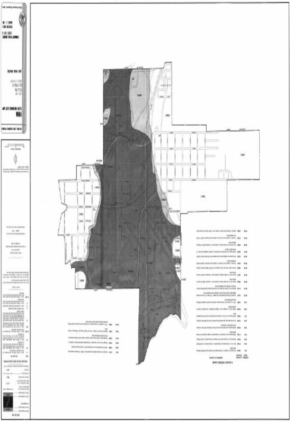
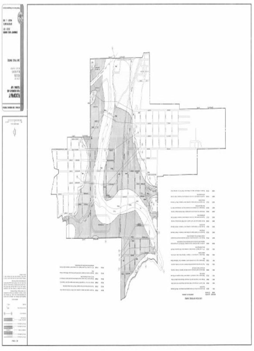
1 Floodplain Information A large percentage of the Ellis community is located in the floodplain of Big Creek. The term floodplain means the low-lying areas on both sides of Big Creek that will be covered with rising water in the event of a flood. The floodplain is called Zone A on the City s flood map, which has been provided by the Federal Emergency Management Agency (FEMA). The floodplain is shown on the map as the area that will be under water when Big Creek floods. The floodplain of Big Creek includes the normally dry area adjacent to the banks of the creek plus the creek channel itself. The floodplain is the land area that conveys the base flood discharge. The heights of the base flood discharge within the floodplain of Big Creek are printed on the FEMA map as elevations measured in feet above sea level. The flood heights of the base flood discharge are shown on the FEMA map and are called Base Flood Elevations (BFEs). The City has a Floodplain Management Ordinance that requires all development activities that are proposed to occur in Zone A must be issued a floodplain development permit by the City before the work begins. Floodplain development includes new construction, substantial improvement, minimal improvement, filling, grading, and excavating. The Ordinance requires that in Zone A, new construction of structures, which includes the placement of manufactured homes and the substantial improvement of existing structures, must be elevated so that the lowest floor, including basement, is a minimum of one foot above the BFE shown on the FEMA flood map. The term substantial improvement means that the cost of any reconstruction, rehabilitation, addition or other improvement of a structure equals or exceed 50 percent of the market value of the structure before the start of the construction of the improvement. For more information about calculating substantial improvement, please contact the City Floodplain Administrator listed. If improvements to an existing structure do not add up to more than 50 percent of the structure s current value, the structure has not been substantially improved and therefore is not required to be elevated. However, a floodplain development permit is still required before improvements begin. The Floodplain Management Ordinance requires that a permit be issued by the City to the property owner prior to beginning construction activities in both districts of Zone A. A Floodplain Development Application must be completed prior to beginning any type of construction or development activity in the Floodway Fringe District and the Floodway District. The Floodplain Administrator reviews the floodplain development application to determine if the proposed activity is in compliance with the City s Ordinance. If the application for floodplain development is approved, the Floodplain Administrator will issue a Floodplain Development Permit that officially authorizes the development activity described on the permit to begin.

2 The Floodway Fringe District is the area located near the outer boundary of Zone A. The Floodway Fringe District lies on both sides of the main channel of Big Creek. The Floodway Fringe is characterized during flooding by the presence of rising floodwater that has minimal velocity. The Floodway Fringe is an area of floodwater impoundment. Residential Structures: Requires new construction or substantial improvement to have the lowest floor, including basement, elevated a minimum of one foot above the BFE. Non-Residential Structures: Requires new construction or substantial improvement to have the lowest floor including basement elevated a minimum of one foot above the BFE. OR acquire from the City a Variance to the Floodplain Management Ordinance that allows the lowest floor of the nonresidential structure to be built below the BFE. The Ordinance lists very specific and limited circumstances that allow for the issuance of a Variance for construction below BFE of a nonresidential structure. A Variance can only be issued for the reasons stated in the Ordinance. A Variance for a non-residential structure requires that the structure must be wet-flood proofed. This means that the structure must have a minimum of two flood water openings with each located on different sides of the building sidewalls with the lowest side of the openings no more than one foot above grade. Doors, garage doors and windows are not considered floodwater openings. The total net area of the floodwater openings must equal one square inch for every square foot of enclosed floor space subject to flooding. Flood proofing requires that all utilities and service equipment be installed a minimum of one foot above BFE. Flood proofed structures are at greater risk of flooding than structures elevated one foot above BFE and will have higher cost flood insurance premiums. The City will complete a FEMA Non-Residential Flood proofing Certificate to be attached to the Variance and the Floodplain Development Permit. The Floodway District is the main channel of Big Creek and the area near the channel that will convey the majority of floodwater in the event of the base flood discharge. The Floodway is the area that conveys most of the floodwater downstream and therefore has the highest floodwater velocity. The Floodway must not be obstructed by development of any type. Construction in the Floodway District is prohibited unless certification is provided by a licensed professional engineer that the proposed development will not result in any increase (0.00 feet) in the flood height shown on the FEMA flood map during occurrence of the base flood discharge. No type of development is allowed that shall increase the height of the base flood discharge. The engineering analysis is called the No-Rise Certification. Floodway development cannot occur without a No-Rise. If a No-Rise Certification is provided by an engineer, the proposed development shall meet all other requirements of the ordinance including elevation above BFE. Variances are not allowed for development in the Floodway.

3 Flood protection for the city of ellis Flooding in our city is caused by one main source: Big Creek leaves its banks in a course of heavy storms, along with ice melting or ice jams. Floodwaters can cover many blocks up to dangerous levels. Sometimes floodwater does not get deep but still covers streets and yards and can flood autos, garages, basements, and some lower floors. Flooding in areas can come with little warning. As the flooding here in Ellis in 1957 and in 1993, it can be in the downtown area quickly. Floods are dangerous. Even if they appear to move slowly, a flood two feet deep can knock a person off their feet, and float a car. Your property may be high enough that it has not flooded recently or at all. However, it can still be flooded in the future because the next or future floods my continually get worse. If you are in or close to a floodplain, odds are that you may experience damage to your property someday. Following are ideas to help you protect yourself. 1.City of Ellis Flood Services: The first thing to do if you think you are in or close to a floodplain is to contact the Public Works Department at City Hall ( ) or the City of Ellis Public Library for information on floods. The Public Works Department has information on flood proofing, flood protection, and flood areas located within the city. We have forms that you may give to an engineer, contractor, or surveyor to establish areas you may buy or live in as to floodplain information. If you wish to visit the Public Works Department, we can also give you names and numbers of these individuals. 2. What you can do: Success of the City s efforts depends a lot on your cooperation and assistance. Here is how you can help: A. Do not dump or throw anything into ditches or streams. Dumping in ditches and streams are violations of local and state laws. Even grass clippings and branches can accumulate and plug channels. A plugged channel cannot carry water, and when it rains in excessive amounts the water has to go somewhere. Every piece of trash can cause worse flooding. B. If your property is next to a ditch or stream, please do your part to keep banks clear of brush and debris. C. If you see dumping in ditches or streams, contact the Public Works Department at D. Always check with Public Works before you start to build on, alter, regrade, or fill your property if it is located in a floodplain. A Flood Development Permit is required to ensure that projects do not cause problems on other properties. Visit the Public Library or City Hall and pick up the following information on flood proofing, flood insurance, and flood safety. FLOODPROOFING: There are several different ways to protect a building from flood damage. One way is to keep the water away by regrading your lot or building a small floodwall, or earthen berm. These methods work if your lot is large enough, if flooding is not too deep, and if your property is not in the FLOODWAY. The Public Works Department can provide this information.

4 Another approach is to make the walls of your building waterproof and place watertight closures over the doorways. This method is not recommended for houses with basements or if water gets over two feet deep. Another approach is to raise the building above flood levels. A small home can be elevated. Sound crazy? Many houses, even those not in the floodplain, have sewers that backup into the basement during heavy storms. A plug or standpipe can stop this if water does not get more than two feet deep. They can be purchased at your local hardware store for a nominal price. For deeper sewer backup flooding, talk to a plumber about overhead discharge with lift stations, or using backup valves. These measures are called flood proofing or retrofitting. More information is available through the City s handouts or through the City Public Library. An important note: Any alteration to your building or land requires a permit from the City if you are in the floodplain. Even regrading or filling in the floodplain requires a permit. If you know a flood is coming, you should have the gas and electricity shut off and move valuable contents to higher ground. It is unlikely that you will receive much warning, so a detailed checklist prepared in advance would help ensure you do not forget important things. FLOOD INSURANCE: If you do not have flood insurance, talk to your insurance agent. Homeowner s Insurance DOES NOT cover flood damage. However, the City of Ellis participates in the National Flood Insurance Program and you can purchase a separate flood insurance policy. This insurance is backed by the Federal government and is available to everyone, even for properties that have previously flooded. Some people have purchased flood insurance because it was required by the bank when they purchased and mortgaged their home or for home improvement. Usually these policies just cover the building s structure and not the contents. During the flooding that could happen in Ellis, there will be usually more damage to the contents than to the structure. *At last count there were 152 insurance policies, $72,072 in premiums, $7,925,800 of insurance in force with 3 paid losses totaling $11,528 in the City of Ellis. If you are covered check out the amount and the deductible and make sure you have content coverage. Remember: Even if a flood would miss you or you have done flood proofing, each flood could be worse than the one before. Flood insurance covers all surface floods. If your flooding problem is caused by sewer backup, check out a sewer backup rider for your homeowner s policy. FOR YOUR SAFETY PRACTICE THE FOLLOWING *Do not walk through flowing waters: Drowning is the number one cause of flood deaths, mostly during flash flooding. Currents can be deceptive: six inches of moving water can knock you off your feet. If you walk in standing water use a pole or stick to ensure the ground is still there. *Do not drive through a flooded area: More people drown in their cars than anywhere else. Do not drive around road blocks as bridges or roads may be washed out. *Stay away from power lines and electrical wires: The number two flood killer after drowning is electrocution. Electrical current travels through water. Report downed lines to Midwest Energy ( ) or to the City ( ).

5 *Have your electricity turned off by Midwest Energy: Some appliances, such as TV s keep electrical charges even after they are unplugged. Do not use appliances or motors until they have been dissembled, cleaned and dried. *Look out for animals, especially snakes: Small animals that have been flooded out of their homes will seek shelter in yours. Use a pole or stick to turn over things and scare away small animals. *Look before you step: After a flood, the ground and floors are covered with debris including broken bottles and nails. Floors and stairs that have been covered in mud are very slippery. *Be alert for gas leaks: Use a flashlight to inspect damage and do not smoke or use candles, lanterns, or open flames unless you know the gas has been turned off and the area ventilated. DO NOT WAIT FOR THE NEXT FLOOD TO BUY INSURANCE!!! THERE IS A 30-DAY WAITING PERIOD BEFORE NATIONAL FLOOD INSURANCE PROGRAM COVERAGE TAKES EFFECT. CONTACT YOUR INSURANCE AGENT FOR MORE INFORMATION ON RATES AND COVERAGE. FLOOD INSURANCE NFIP: This community participates in the National Flood Insurance Program (NFIP). The NFIP makes federally backed flood insurance available for all buildings, whether they are in a floodplain or not. Flood insurance covers direct loss caused by surface flooding, including a river flowing over its banks, a lake or ocean storm, and local drainage problems. The NFIP insures buildings, including mobile homes, with two types of coverage: structural and contents. Structural coverage is for the walls, floors, insulation, furnaces, and other items permanently attached to the structure. Contents coverage may be purchased separately provided the contents are in an insurable building. Mandatory Purchase Requirement: The mandatory purchase requirement applies to all forms of federally related financial assistance for buildings located in a Special Food Hazard Area (SFHA). The requirement affects loans and grants for the purchase, construction, repair, or improvement of any publicly or privately owned building in the SFHA, including machinery, equipment, fixtures, and furnishings contained in such buildings. Financial assistance programs affected include loans and grants from agencies such as the Department of Veterans Affairs, Farmers Home Administration, Federal Housing Administration, Small Business Administration, and Federal Emergency Management Agency. The requirement also applies to secured mortgage loans from financial institutions, such as commercial lenders, savings and loan associations, savings banks, and credit unions that are regulated, supervised or insured by federal agencies such as the Federal Deposit Insurance Corporation and the Office of Thrift Supervision. It also applies to all mortgage loans purchased by Fannie Mae or Freddie Mac in the secondary mortgage market. How it Works: Before a person can receive a loan or other financial assistance from one of the affected agencies or lenders, there must be a check to see if the building is in a SFHA. The SFHA is the base (100- year) floodplain mapped on a Flood Insurance Rate Map (FIRM). It is shown as one or more zones that begin with the letter A or V.

6 Copies of the FIRM are available for review in most local government buildings or planning departments. Many lenders and insurance agents have copies, also. It is the agency s or the lender s responsibility to check the FIRM to determine if the building is in a SFHA, although many communities provide assistance. If the building is in an SFHA, the agency or lender is required by law to require the recipient to purchase a flood insurance policy on the building. The requirement is for structural coverage equal to the amount of the (or other financial assistance) or the maximum amount available, whichever is less. The maximum amount available for a single-family house is $250,000. The mandatory purchase requirement does not affect loans or financial assistance for items that are not covered by a flood insurance policy, such as vehicles, business expenses, landscaping, and vacant lots. It does not affect loans for buildings that are not in the SFHA, even though a portion of the lot may be flood-prone. While not mandated by law, a lender may require a flood insurance policy for a property in any zone on a Flood Insurance Rate Map. For information about flood risks and insurance visit: Elevation certificates are required in City of Ellis. Information and documents available at: View flood maps on line or make a FIRMette at If You Have Questions concerning new construction, remodeling or additions within the Floodway Fringe and the Floodway districts, please contact the Floodplain Administrator at (785) or (785) or at ellispw@eaglecom.net
 or the maximum amount available, whichever is less.")
7
8
9

CITY OF WOODSTOCK NATIONAL FLOOD INSURANCE PROGRAM INFORMATION
 CITY OF WOODSTOCK NATIONAL FLOOD INSURANCE PROGRAM INFORMATION The City of Woodstock participates in the National Flood Insurance Program (NFIP). The NFIP makes federally backed flood insurance available
Flood Protection Tips
 Flood Protection Tips Information About Floodplains and Flood Prevention What is a floodplain? Floodplains serve many useful purposes, and those that are preserved in their natural or nearly natural state
The. year. floods are
 Introduction The Ascension Parish Council is dedicated to minimizing thee loss of life and property that is associated with flooding events. Education and prevention are valuable and proven tools that
FLOOD DAMAGE PRECAUTIONS
 FLOOD DAMAGE PRECAUTIONS 1. Prepare for flood events: Know how to shut off the electricity and gas to your house in a flood event. Make a list of emergency numbers and identify a safe place to go make
Flood Protection Information Flood Basics
 Flood Protection Information Flooding is an act of nature which respects no boundary lines, either community or personal. Floodwater can cover many blocks with water depths up to four or five feet and
2015 CRS Community Outreach. City of Folly Beach, South Carolina Flood Plain Management Offices PO Box 48 Folly Beach, SC 29439 843-588-2447 ext 1838
 City of Folly Beach, South Carolina Flood Plain Management Offices PO Box 48 Folly Beach, SC 29439 843-588-2447 ext 1838 The dark line around this map delineates the extent of the Special Flood Hazard
TOWN OF AMHERST BUILDING DEPARTMENT
 TOWN OF AMHERST BUILDING DEPARTMENT ERIE COUNTY, NEW YORK 5583 MAIN STREET WILLIAMSVILLE, NEW YORK 14221 PHONE: (716) 631-7080 THOMAS C. KETCHUM, P.E. Commissioner of Building FAX: (716) 631-7192 February
National Flood Safety Awareness Week is March 16-20, 2015
 Armond Budish Cuyahoga County Executive FOR IMMEDIATE RELEASE Media Contacts: Christopher Harris: (216) 443 7157 or cbharris@cuyahogacounty.us Rich Luchette: (216) 698 5637, (216) 797 0931, or rluchette@cuyahogacounty.us
ETNA BOROUGH PUBLIC SAFETY NEWSLETTER OCTOBER 2014
 BOROUGH CONTACTS Borough of Etna 437 Butler Street For Emergencies Call: 911 (Allegheny County Communications Center) Pittsburgh, PA 15223 Borough Office: 412 781-0569 Fax: 412 782-5302 E-Mail: info@etnaborough.org
The Basics of Indian Rocks Beach and Flood Hazard Information
 Helpful Flood Hazard Information Are you doing all you can to protect your property from flood damage? You have received this letter because your property is in an area that is subject to flooding. The
CHAPTER 3 page 69 LOCAL FLOODPLAIN REGULATIONS AND NFIP STANDARDS
 CHAPTER 3 page 69 LOCAL FLOODPLAIN REGULATIONS AND NFIP STANDARDS LOCAL FLOODPLAIN REGULATIONS AND NFIP STANDARDS, page 69 THE PARTICIPATION OF A COMMUNITY IN THE NFIP IS MADE POSSIBLE BY ITS ADOPTION
Frequently-Asked Questions about Floodplains and Flood Insurance FLOOD INSURANCE
 Frequently-Asked Questions about Floodplains and Flood Insurance What is a floodplain? The floodplain is any area covered by water during normal water flows, and which could be inundated as a result of
Flood Insurance. NFIP Flood Insurance
 Flood Insurance 11 Flood insurance is essential in helping people repair, recover, rebuild, and even install some retrofitting measures. Flood insurance has many advantages, especially for people in areas
Division of Water Frequently asked floodplain questions
 Division of Water Frequently asked floodplain questions Q: Where can I find copies of the floodplain mapping? A: Local floodplain administrators will have copies of the FEMA mapping. (Generally the local
Insurance Questions: Clothes washers and dryers, food freezers and the food in them are covered if there is contents coverage.
 Introduction: Floods occur when runoff from rain or snowmelt exceeds the capacity of rivers, stream channels or lakes and overflows onto adjacent land. Floods can also be caused by storm surges and waves
TOWN OF HARRISBURG FIRE DEPARTMENT 6450 Morehead Road, Harrisburg North Carolina 28075 Phone: 704 455 3574 Fax 704 455 6391 www.harrisburgfd.
 FLOOD FACTS AND SAFETY TIPS Floods are one of the most common hazards in the United States. Flood effects can be local, impacting a neighborhood or community, or very large, affecting entire river basins
2012 Flood Hazard Prevention By Building and Planning Operations Manager Lou Ann Patellaro
 2012 Flood Hazard Prevention By Building and Planning Operations Manager Lou Ann Patellaro In 1968, Congress created the National Flood Insurance Program (NFIP) to provide affordable flood insurance to
Floodplains are lands that are subject to periodic flooding from water. Floodplains in their natural state:
 A GUIDE TO FLOOD HAZARDS Prepared by the Harford County Department of Planning and Zoning This document is available in alternative format upon request. NATURAL BENEFITS OF FLOODPLAINS Floodplains are
Control filling, grading, dredging, and other development which may increase erosion or flood damage; and
 ARTICLE 16. FLOOD DAMAGE PREVENTION Section 16-1: Findings of Fact The flood hazard areas of the Town of Lillington are subject to periodic inundation which results in loss of life and property, health
EXISTING STRUCTURES 1) FAIR MARKET VALUE OF STRUCTURE(s) BEFORE IMPROVEMENT: 2) COST OF IMPROVEMENTS:
 FAIR MARKET VALUE OF STRUCTURE(s) BEFORE IMPROVEMENT: 2) COST OF IMPROVEMENTS:") Date Received: Received By: Project/Permit Number: Fee: (To be Completed by MOA) FLOOD HAZARD PERMIT APPLICATION (Please fill out application completely; Indicate NA if necessary. Property information
Date Received: Received By: Project/Permit Number: Fee: (To be Completed by MOA) FLOOD HAZARD PERMIT APPLICATION (Please fill out application completely; Indicate NA if necessary. Property information
Flood Insurance Repetitive Loss Property
 Flood Insurance Repetitive Loss Property When our system of canals, ditches and culverts was built over 20 years ago, it could handle all but the largest tropical storms and hurricanes; since then, urban
Administrative Procedures Regarding the Application of Flood Damage Prevention
 Administrative Procedures Regarding the Application of Flood Damage Prevention A floodplain development permit, conforming to the provisions of the Flood Damage Prevention Ordinance ( the Ordinance, shall
Floodplain Development Land Use Review
 COMMUNITY DEVELOPMENT DEPARTMENT Planning Division P.O. Box 490 333 Broadalbin Street SW Albany, OR 97321 Phone 541-917-7550 Fax 541-791-0150 www.cityofalbany.net Floodplain Development Land Use Review
CITY OF BELLEAIR BEACH, FLORIDA
 CITY OF BELLEAIR BEACH, FLORIDA FLOOD INSURANCE INFORMATION Important Information for City of Belleair Beach Residents and Property Owners Regarding Flood, Risk, Insurance, Preparation, Evacuation, Safety
Permit Application No. Development Address. Legal Description. A. Flood Plain and Floodway Information and Sources: (To be completed with Staff)
") FLOOD PLAIN DEVELOPMENT PERMIT APPLICATION of Olathe, Department of Public Works 1385 S. Robinson Drive P.O. Box 768 Olathe, Kansas 66051-0768 (913) 971-9045 FAX (913) 971-9099 Olathe, Kansas, Community
FLOOD PLAIN DEVELOPMENT PERMIT APPLICATION of Olathe, Department of Public Works 1385 S. Robinson Drive P.O. Box 768 Olathe, Kansas 66051-0768 (913) 971-9045 FAX (913) 971-9099 Olathe, Kansas, Community
DEPARTMENT OF PLANNING AND DEVELOPMENT
 DEPARTMENT OF PLANNING AND DEVELOPMENT FLOODPLAIN DEVELOPMENT PERMIT APPLICATION FOR NON-RESIDENTIAL DEVELOPMENT Property Owner Telephone Street/P.O. Box City State ZIP Agent (if any) Relationship to Property
CASS COUNTY COMMISSION POLICY MANUAL 38.07 ADOPTED DATE: FEBRUARY 2, 1998 PAGE 1 OF 9
 CASS COUNTY COMMISSION POLICY MANUAL 38.07 SUBJECT: ORDINANCE #1998-2 (FLOOD DAMAGE PREVENTION) ADOPTED DATE: FEBRUARY 2, 1998 PAGE 1 OF 9 NORTH DAKOTA COUNTY OF CASS ORDINANCE #1998-2 Be it ordained and
http://library1.municode.com/default/docview/10251/1/101/103
 Page 1 of 8 ARTICLE II. FLOOD DAMAGE PREVENTION* *Cross references: Buildings and building regulations, ch. 67; floor elevation standards, 67-32; flood damage prevention for utility systems, 67-34; drainage
Flood Insurance Secrets That Most Agents Won t Tell You and Most People Don t Find Out Until It s Too Late!
 Flood Insurance Secrets That Most Agents Won t Tell You and Most People Don t Find Out Until It s Too Late! By Scott Kirby, Licensed Insurance Agent and Consumer Advocate In this report, you will discover
Teller County, Colorado Floodplain Development Permit Application
 Teller County, Colorado Floodplain Development Permit Application This is an application packet for a Floodplain Development Permit (FDP). Certain sections are to be completed by the Applicant, and certain
5.0 OVERVIEW OF FLOOD DAMAGE REDUCTION MEASURES
 5.0 OVERVIEW OF FLOOD DAMAGE REDUCTION MEASURES Flood damage reduction consists of two basic techniques structural and non-structural. Structural methods modify the flood and take the flood away from people
FLOOD DAMAGE PREVENTION ORDINANCE
 FLOOD DAMAGE PREVENTION ORDINANCE SECTION 1.0 STATUTORY AUTHORIZATION, FINDINGS FO FACT, PURPOSE, AND OBJECTIVES 1.1 STATUTORY AUTHORIZATION The Legislature of the State of Washington has in RCW delegated
Information For Residents In The High-Risk Flood Zone
 Information For Residents In The High-Risk Flood Zone YOUR FLOOD HAZARD RISK You are receiving this informational flyer as part of a public safety education campaign by Hillsborough County. The flyer is
Kentucky Model Flood Damage Prevention Ordinance. 2015 KAMM Annual Conference Carey Johnson Kentucky Division of Water
 Kentucky Model Flood Damage Prevention Ordinance 2015 KAMM Annual Conference Carey Johnson Kentucky Division of Water Flood Damage Prevention Ordinance Also referred to as Floodplain Management Ordinance
Reducing Flood Risk to Residential Buildings That Cannot Be Elevated
 Reducing Flood Risk to Residential Buildings That Cannot Be Elevated FEMA P-1037 / September 2015 Elevated utility readable from standing height ~6.5' above grade Basement infill with gravel Approximate
ARTICLE 12 FLOOD DAMAGE PREVENTION
 ARTICLE 12 FLOOD DAMAGE PREVENTION SECTION 12.1 AUTHORIZATION 12.1.1 General The Legislature of the State of North Carolina has in Part 6, Article 21 of Chapter 143; Parts 3 and 4 of Article 18 of Chapter
LOS ANGELES COUNTY S FLOODING HISTORY:
 LOS ANGELES COUNTY S FLOODING HISTORY: Since 1975, Los Angeles County has experienced twelve federally, declared flood disasters, with three of those disasters coming under El Niño conditions (1983, 1998,
Elevating Your House. Introduction CHAPTER 5
 CHAPTER 5 Elevating Your House Introduction One of the most common retrofitting methods is elevating a house to a required or desired Flood Protection Elevation (FPE). When a house is properly elevated,
Myths and Facts about the NFIP
 Chapter 4: After the Disaster How the NFIP Works Who needs flood insurance? Everyone. And everyone in a participating community of the National Flood Insurance Program (NFIP) can buy flood insurance. More
SECTION 19 RESIDENTIAL CONSTRUCTION IN FLOODZONES
 SECTION 19 RESIDENTIAL CONSTRUCTION IN FLOODZONES The purpose of the following information and documents are to clarify procedures used by the Sonoma County Permit & Resource Management Department to enforce
OKANOGAN COUNTY OFFICE OF PLANNING AND DEVELOPMENT FLOODPLAIN DEVELOPMENT PERMIT APPLICATION
 OKANOGAN COUNTY OFFICE OF PLANNING AND DEVELOPMENT FLOODPLAIN DEVELOPMENT PERMIT APPLICATION Okanogan County Code, OCC 15.08, Floodplain Management The State of Washington has authorized county governments
REBUILDING BELMAR ABFE FLOOD MAPS &THE REBUILDING PROCESS
 REBUILDING BELMAR ABFE FLOOD MAPS &THE REBUILDING PROCESS REBUILDING BELMAR ABFE Maps Preliminary FIRM Maps Flood Insurance Increased Cost of Compliance (ICC) Elevation of Structures Building Permits Acronyms
Protect Your Property
 Protect Your Property There are many ways you can protect your home, garage or other property from the types of flood damage experienced in your community. Different techniques are appropriate for different
156. FLOOD DAMAGE PREVENTION
 156. FLOOD DAMAGE PREVENTION 156.01. STATUTORY AUTHORIZATION The Indiana Legislature has granted the power to local units of government (IC 36-1-3-1 et seq.) to control land use within their jurisdictions
In addition to the terms defined in this By-law, the following terms shall have the corresponding meanings for the purposes of this Section:
 Click here to access definitions SECTION 12 FLOODPLAIN LANDS 12.1 INTERPRETATION In addition to the terms defined in this By-law, the following terms shall have the corresponding meanings for the purposes
Flood Insurance Coverage/Rates Summary Excerpted From Unit 9 of Managing Floodplain Development Through the National Flood Insurance Program
 Flood Insurance Coverage/Rates Summary Excerpted From Unit 9 of Managing Floodplain Development Through the National Flood Insurance Program Amount of coverage Insurance rates for all buildings are based
BEFORE A FLOOD Prepare a family disaster plan and a disaster
 The City of Fort Lauderdale participates in the National Flood Insurance Program (NFIP) so that residents can obtain flood insurance to cover their property against loss from flood damage. Participation
1. Review your insurance policies and coverage with your local agent.
 Dear Orange Beach Resident: The Community Development Office of The City of Orange Beach, Alabama is providing this information to the residents as part of a public outreach strategy as developed by the
PREVENTION. City of Orem FLOOD DAMAGE PREVENTION 10-1-1
 City of Orem FLOOD DAMAGE PREVENTION 10-1-1 CHAPTER 10. Article 10-1. Article 10-2. Article 10-3. Article 10-4. Article 10-5. FLOOD DAMAGE PREVENTION Purposes Definitions General Provisions Administration
SECTION 15 FLOODPLAIN MANAGEMENT
 SECTION 15 15.1 Purpose Certain areas of the City of Gardiner, Maine, are subject to periodic flooding, causing serious damages to properties within these areas. Relief is available in the form of flood
Important safety tips for Electric and Gas Safety. Source: PSEG Hurricane Irene Web site on InfoCentral
 Hurricane Readiness Important safety tips for Electric and Gas Safety Source: PSEG Hurricane Irene Web site on InfoCentral For updates on PSE&G outage information, please visit: www.twitter.com\psegoutageinfo
Home Repair After a Hurricane Disaster
 FACILITATOR GUIDE ACTIVITY: COMING HOME AFTER A DISASTER Purpose: The purpose of this activity is to educate individuals and families about what to consider after their home has been damaged after a disaster
OWNERS NAME PHONE OWNERS ADDRESS APPLICANTS NAME PHONE APPLICANTS ADDRESS
 TOWN OF SWANSBORO 502 Church Street, Swansboro, NC 28584 FLOODPLAIN DEVELOPMENT PERMIT OWNERS NAME PHONE OWNERS ADDRESS APPLICANTS NAME PHONE APPLICANTS ADDRESS Per Article 21, Section 21-7. Establishment
QUESTIONS AND ANSWERS REGARDING PARTICIPATION IN THE NATIONAL FLOOD INSURANCE PROGRAM
 QUESTIONS AND ANSWERS REGARDING PARTICIPATION IN THE NATIONAL FLOOD INSURANCE PROGRAM 1. What are the consequences of not joining the NFIP? Specifically regarding FEMA reimbursement funds and damage to
Appendix B. Property Owner Questionnaire
 Appendix B Property Owner Questionnaire WEST WINDSOR TOWNSHIP DEPARTMENT OF COMMUNITY DEVELOPMENT PROPERTY QUESTIONNAIRE DIVISION OF ENGINEERING As someone who owns and lives and/or works on a property
Changing Flood Maps: A Guide for Homeowners and Consumers
 Changing Flood Maps: A Guide for Homeowners and Consumers The flood maps in your community are being changed. What does this mean to you? Flood maps, also known as Flood Insurance Rate Maps or FIRMs, are
Flood Insurance for Risk Managers
 Flood Insurance for Risk Managers Basics of the National Flood Insurance Program August 20, 2012 Susan W. Wilson DHS/FEMA Region IV NFIP Created by National Flood Insurance Act of 1968 THIS Adopt a local
Kanawha County Floodplain Regulations Quick Guide & Overview
 Kanawha County Floodplain Regulations Quick Guide & Overview CHUCK GRISHABER, CFM KANAWHA COUNTY FLOOD PLAIN MANAGER Office: 304.357.0570 Mobile: 304-356.0979 Fax: 304.357.0572 chuckgrishaber@kanawha.us
Sample Flood Damage Prevention Ordinance
 Sample Flood Damage Prevention Ordinance COUNTY OF RABUN STATE OF GEORGIA ORDINANCE AN ORDINANCE ADOPTING FLOOD DAMAGE PREVENTION REGULATIONS OF THE CITY OF CLAYTON, GEORGIA WHEREAS; The Mayor and City
ARE YOU PREPARED FOR A FLOOD IN YOUR NEIGHBORHOOD?
 ARE YOU PREPARED FOR A FLOOD IN YOUR NEIGHBORHOOD? YOU ARE RECEIVING THIS BROCHURE BECAUSE YOUR PROPERTY IS LOCATED WITHIN OR NEAR A SPECIAL FLOOD HAZARD AREA WITHIN UNINCORPORATED VENTURA COUNTY History
CITY OF NORTH RIDGEVILLE 7307 AVON BELDEN ROAD NORTH RIDGEVILLE, OH 44039 (440) 353-0819 WWW.NRIDGEVILLE.ORG
 353-0819 WWW.NRIDGEVILLE.ORG") CITY OF NORTH RIDGEVILLE 7307 AVON BELDEN ROAD NORTH RIDGEVILLE, OH 44039 (440) 353-0819 WWW.NRIDGEVILLE.ORG WHY IS THERE WATER IN MY BASEMENT? There are two major sources of water in a basement as the
CITY OF NORTH RIDGEVILLE 7307 AVON BELDEN ROAD NORTH RIDGEVILLE, OH 44039 (440) 353-0819 WWW.NRIDGEVILLE.ORG WHY IS THERE WATER IN MY BASEMENT? There are two major sources of water in a basement as the
Cabarrus County Floodplain Information TABLE OF CONTENTS
 Cabarrus County Floodplain Information TABLE OF CONTENTS Flood Hazard What is 100-year flood? Does Cabarrus County flood? Flood Safety How do I protect my property from flood damage? Is there anything
Openings in Foundation Walls for Buildings Located in Special Flood Hazard Areas
 Openings in Foundation Walls for Buildings Located in Special Flood Hazard Areas in accordance with the National Flood Insurance Program FEDERAL EMERGENCY MANAGEMENT AGENCY FEDERAL INSURANCE ADMINISTRATION
TITLE 8 FLOOD DAMAGE PREVENTION
 Henry County Development Code Flood Damage Prevention TITLE 8 FLOOD DAMAGE PREVENTION SECTION 1.0 FLOOD DAMAGE PREVENTION: STATUTORY AUTHORIZATION The Indiana Legislature granted the power to local units
Chapter 5: Property Protection
 Chapter 5: Property Protection Property protection measures are used to protect property that is in danger from damage caused by natural hazards. Property owners are responsible for implementing protective
SANITARY SEWER BACKUP. Causes & Prevention
 SANITARY SEWER BACKUP Causes & Prevention A. PURPOSE The purpose of this publication is twofold: 1. It provides homeowners with basic information on the causes of sanitary sewer backups. 2. It provides
CHAPTER 152: FLOOD DAMAGE PREVENTION
 CHAPTER 152: FLOOD DAMAGE PREVENTION 00-15-152-01 Statutory Authority 00-15-152-02 Purpose 00-15-152-03 Definitions 00-15-152-04 Building Commissioner; Powers and Duties 00-15-152-05 Regulatory Flood Elevation
Lincoln County Floodplain Development Permit Application
 Lincoln County Floodplain Development Permit Application Application # FP Use Permit Variance Appeal Date SECTION I: GENERAL PROVISIONS (APPLICANT to read and sign) 1. No work of any kind may start until
Y A V A P A I C O U N T Y FLOOD CONTROL D I S T R I C T
 Y A V A P A I C O U N T Y FLOOD CONTROL D I S T R I C T 1120 COMMERCE DRIVE PRESCOTT, AZ 86305 928.771.3197 PHONE 928.771.3427 FAX 10 S. 6 TH STREET COTTONWOOD, AZ 86326 928.639.8151 PHONE 928.639.8118
Federal Triangle Stormwater Working Group Federal Triangle Floodproofing Seminar BUILDING STRONG SM
 Federal Triangle Stormwater Working Group Federal Triangle Floodproofing Seminar Initial Risk Flood Risk = Probability of Flooding x Consequences Zoning Building Codes Outreach Evacuation Planning Risk
Flood Protection Information
 A Fairfax County, Va., publication September 2015 SFHA 1 Flood Protection Information Saving Lives and Protecting Property September 2015 Your property is in or near a Special Flood Hazard Area (SFHA)
Substantial Improvement/Substantial Damage for Floodplain Administrators Mitigation Fact Sheet
 Substantial Improvement/Substantial Damage for Floodplain Administrators Mitigation Fact Sheet Substantial Improvement/Substantial Damage are everyday issues, not just post-disaster; and they apply to
Elevator Installation for Buildings Located in Special Flood Hazard Areas in accordance with the National Flood Insurance Program
 Elevator Installation for Buildings Located in Special Flood Hazard Areas in accordance with the National Flood Insurance Program FEDERAL EMERGENCY MANAGEMENT AGENCY FEDERAL INSURANCE ADMINISTRATION FIA-TB-4
Chapter 15.12 FLOOD DAMAGE PREVENTION
 Chapter 15.12 FLOOD DAMAGE PREVENTION Sections: 15.12.010 Findings of fact. 15.12.020 Statement of purpose. 15.12.030 Methods of reducing flood losses. 15.12.040 Definitions. 15.12.050 Lands to which this
Chapter 24.16 FLOOD DAMAGE PREVENTION
 1 1 Chapter. FLOOD DAMAGE PREVENTION Sections..0 Page Statutory Authorization...1..0 Findings of Fact...1..0 Statement of Purpose...1..0 Methods of Reducing Flood Losses...1..0 Applicability.....00 Basis
UNIT 9: FLOOD INSURANCE AND FLOOD MANAGEMENT
 UNIT 9: FLOOD INSURANCE AND FLOOD MANAGEMENT In this unit While you are probably not an insurance agent, you should be aware of the close relationship between floodplain management and flood insurance.
FEMA P-936 Floodproofing Non-Residential Buildings ASFPM 2013
 FEMA P-936 Floodproofing Non-Residential Buildings ASFPM 2013 1.1 Floodproofing Non-Residential Buildings Design Manual (FEMA P-936) 1. Existing non-residential buildings in riverine areas subject to shallow
CITY OF NORTHWEST FLOOD DAMAGE PREVENTION ORDINANCE. Non-Coastal Regular Phase
 CITY OF NORTHWEST FLOOD DAMAGE PREVENTION ORDINANCE Non-Coastal Regular Phase ARTICLE 1. STATUTORY AUTHORIZATION, FINDINGS OF FACT, PURPOSE AND OBJECTIVES. SECTION A. STTUTORY AUTHORIZATION. Municipal:
NYSDEC Optional Additional Language Model Local Law for Flood Damage Prevention Optional Additional Language
 NYSDEC General Comments. The contains language that complies with the floodplain management requirements of the National Flood Insurance Program (NFIP) contained in federal regulations 44 CFR 60.3 through
rescue and relief efforts in the aftermath of flooding, (iii) repair of flood damaged public facilities and utilities, and
 repair of flood damaged public facilities and utilities, and") 1. Purpose (1) It is the purpose of this Ordinance to protect human life, health, and property from flood conditions, to preserve the ability of floodplains to carry and discharge a base flood, and to
1. Purpose (1) It is the purpose of this Ordinance to protect human life, health, and property from flood conditions, to preserve the ability of floodplains to carry and discharge a base flood, and to
PENNINGTON COUNTY FLOOD DAMAGE PREVENTION ORDINANCE
 Last Revision Date: May 12, 1998 TABLE OF CONTENTS SECTION 100 - STATUTORY AUTHORIZATION, FINDINGS OF FACT, TITLE, PURPOSE AND METHOD..2 101. STATUTORY AUTHORIZATION 102. FINDINGS OF FACT 103. TITLE 104.
Pennsylvania Flood Safety Awareness Week March 6-10th, 2015
 Pennsylvania Flood Safety Awareness Week March 6-10th, 2015 David J. Nicosia Warning Coordination Meteorologist National Weather Service Binghamton, NY Flooding is a coast to coast threat to the United
CHAPTER IV PREVENTING INCREASED DAMAGES
 Chapter Summary Preventing increased flood damage is one of the major objectives of floodplain regulations. Primarily, this means local governments must prohibit any development that obstructs flood flows
Mississippi Emergency Management Agency
 Mississippi Emergency Management Agency Floodplain Management Bureau A Citizen s Guide: Flood Protection Measures Produced in conjunction with your local community. MEMA: 1-866-519-MEMA (6362) MEMA Website:
Flood Damage Prevention
 City of Talent Flood Damage Prevention General Ordinances, Title 8, Chapter 5 Adopted by Ordinance No. 752 on 4 February 2004 SECTION 1.0: STATUTORY AUTHORIZATION, FINDINGS OF FACT, PURPOSE, AND OBJECTIVES
Flood Insurance Essentials
 (Examples adapted from materials developed for FEMA/NFIP training for insurance agents.) Flood Insurance Essentials Agent Training for the National Flood Insurance Program The Least You Need to Know Every
Basement Flooding: Preventing Future Damage
 Basement Flooding: Preventing Future Damage 1 Mitigation Mitigation is Measures taken now to reduce losses in the future. 2 Protecting Your Property Staying Above Water There are many low-cost options
With a combination of soaking rain, flying debris, high winds, and tidal surges, Hurricanes and tropical storms can pack a powerful punch.
 With a combination of soaking rain, flying debris, high winds, and tidal surges, Hurricanes and tropical storms can pack a powerful punch. Besides causing extensive damage in coastal areas, hurricanes
Table of Contents. Comments on the Technical Bulletins should be directed to:
 Openings in Foundation Walls and Walls of Enclosures Below Elevated Buildings in Special Flood Hazard Areas in accordance with the National Flood Insurance Program Technical Bulletin 1 / August 2008 Table
Floods Module 2. - Mitigation Definition- Mitigation includes activities that: Prevent Reduce Lessen NORTHERN ILLINOIS UNIVERSITY COPYRIGHT 2007
 - Mitigation Definition- Mitigation includes activities that: Prevent Reduce Lessen 1 - Community Mitigation - Manage developments within a flood plain Construct barriers Levees Berms Dikes - Community
1. Why is Lee County getting new flood hazard maps? 3. What are the benefits of the new flood hazard maps?
 1. Why is Lee County getting new flood hazard maps? Flood hazard maps, also known as Flood Insurance Rate Maps (FIRMs), are important tools in the effort to protect lives and property. They indicate the
A Guide to Flood Resilient Repairs
 A Guide to Flood Resilient Repairs A Guide to Flood Resilient Repairs Some five million people live under the threat of flooding that s one in ten houses in the UK and 200,000 are very high risk. This
F L O O D P L A I N M A N A G E M E N T I N A R K A N S A S
 F L O O D P L A I N M A N A G E M E N T I N A R K A N S A S 2 0 0 5 Arkansas Natural Resources Commission* Floodplain Management Program http://www.anrc.arkansas.gov *formerly Arkansas Soil & Water Conservation
FLOOD DAMAGE PREVENTION ORDINANCE
 FLOOD DAMAGE PREVENTION ORDINANCE Section 1. Purpose and Objectives This ordinance, when adopted shall replace the Flood Damage Prevention Ordinance of June 10, 1998. It is the purpose of this ordinance
First in Service First in Safety
 7840 Nagle Avenue Morton Grove, Illinois 60053 847-470-5235 Fax - 847-965-9511 Wind Damage; Frequently Asked Questions: What can I do with branches that fall in my yard? Bring them out to the parkway;
Who needs flood insurance? Everyone!
 National Flood Insurance Program Myths and Facts about the National Flood Insurance Program Who needs flood insurance? Everyone! And almost everyone in a participating community of the National Flood Insurance
ORDINANCE NO. 618 BE IT ORDAINED AS FOLLOWS:
 ORDINANCE NO. 618 ORDINANCE OF THE MAYOR AND COUNCIL OF THE BOROUGH OF MANTOLOKING, OCEAN COUNTY, NEW JERSEY, PROVIDING FOR AMENDMENT OF ORDINANCE 525, FLOOD DAMAGE PREVENTION, AND REVISIONS OF CHAPTER
FLOODPLAIN MANAGEMENT IN ILLINOIS
 FLOODPLAIN MANAGEMENT IN ILLINOIS 2001 Illinois Department of Natural Resources Office of Water Resources 524 South Second Street Springfield, IL 62702 (217) 782-3863 http://dnr.state.il.us/waterresources
FEMA Updates Flood Plain Information For 2006
 Flood Insurance Rate Map Changes Informational Meeting For Property Owners Entering the Floodplain Durant Center February 23, 2011 Introductions City of Alexandria Transportation and Environmental Services