DEVELOPMENT OF AN INTERFACE BETWEEN FDOT'S CRASH ANALYSIS REPORTING SYSTEM AND THE SAFETY ANALYST. Contract No.: BDK
|
|
|
- Della McKinney
- 8 years ago
- Views:
Transcription
1 DEVELOPMENT OF AN INTERFACE BETWEEN FDOT'S CRASH ANALYSIS REPORTING SYSTEM AND THE SAFETY ANALYST Contract No.: BDK Written by: Linjun Lu Research Assistant Jian John Lu, Ph.D., P.E., (Principal Investigator) Professor Pei Sung Lin, Ph.D., P.E., PTOE, (Co- Principal Investigator) Program Director of CUTR And Zhenyu Wang, Ph.D. Research Associate Hongyun Chen Research Assistant Transportation Group Department of Civil and Environmental Engineering 4202 E. Fowler Ave., ENB 118 & Center for Urban Transportation Research 4202 E. Fowler Ave., CUT100 University of South Florida Tampa, Florida Presented to: Florida Department of Transportation A Project Sponsored by: Florida Department of Transportation July 2009

2 DISCLAIMER The opinions, findings, and conclusions expressed in this publication are those of the authors and not necessarily those of the State of Florida Department of Transportation. i

3 METRIC CONVERSION CHART SYMBOL WHEN YOU KNOW MULTIPLY BY TO FIND SYMBOL LENGTH in inches 25.4 millimeters mm ft feet meters m yd yards meters m mi miles 1.61 kilometers km SYMBOL WHEN YOU KNOW MULTIPLY BY TO FIND SYMBOL AREA in 2 squareinches square millimeters mm 2 ft 2 squarefeet square meters m 2 yd 2 square yard square meters m 2 ac acres hectares ha mi 2 square miles 2.59 square kilometers km 2 SYMBOL WHEN YOU KNOW MULTIPLY BY TO FIND SYMBOL VOLUME fl oz fluid ounces milliliters ml gal gallons liters L ft 3 cubic feet cubic meters m 3 yd 3 cubic yards cubic meters m 3 NOTE: volumes greater than 1000 L shall be shown in m 3 SYMBOL WHEN YOU KNOW MULTIPLY BY TO FIND SYMBOL LENGTH mm millimeters inches in m meters 3.28 feet ft m meters 1.09 yards yd km kilometers miles mi SYMBOL WHEN YOU KNOW MULTIPLY BY TO FIND SYMBOL AREA mm 2 square millimeters square inches in 2 m 2 square meters square feet ft 2 m 2 square meters square yards yd 2 ha hectares 2.47 acres ac km 2 square kilometers square miles mi 2 SYMBOL WHEN YOU KNOW MULTIPLY BY TO FIND SYMBOL VOLUME ml milliliters fluid ounces fl oz L liters gallons gal m 3 cubic meters cubic feet ft 3 m 3 cubic meters cubic yards yd 3 ii

4 TECHNICAL REPORT DOCUMENTATION PAGE 1. Report No. 2. Government Accession No. 3. Recipient s Catalog No. 4. Title and Subtitle Development of An Interface between FDOT's Crash Analysis Reporting System and the Safety Analyst 7. Author(s) Linjun Lu, Jian John Lu, Pei Sung Lin, Zhenyu Wang, and Hongyun Chen 9. Performing Organization Name and Address Transportation Group, Department of Civil & Environmental Engineering, University of South Florida, 4202 East Fowler Avenue, ENB 118, Tampa, FL Sponsoring Agency Name and Address Florida Department of Transportation 605 Suwannee Street, MS 30 Tallahassee, FL Report Data July Performing Organization Code 8. Performing Organization Report No. 10. Work Unit No. (TRAIS) 11. Contract or Grant No. BDK Type of Report and Period Covered Final, July 2008 to July Sponsoring Agency Code 15. Supplementary Notes 16. Abstract Safety Analyst (SA) is a set of software tools that can be used by state and local highway agencies for highway safety management. It includes a set of tools to implement the procedures that will be presented in Parts IV and V of the forthcoming Highway Safety Manual. These tools include: a Network Screening Tool, a Diagnosis Tool, a Countermeasure Selection Tool, an Economic Appraisal Tool, a Priority Ranking tool, and an Evaluation tool. By using these tools, Safety Analyst can automate procedures that are now performed manually by highway agencies. FDOT maintains a very large crash database called Crash Analysis Reporting (CAR) System. The database was originally generated by merging crash data from the Department of Highway Safety and Motor Vehicles (DHSMV) with roadway information from FDOT. The database is updated yearly. All reported crashes with a fatality, an injury, and high property damage occurred on state roads are included in this database. The database basically contains all the information recorded in the long form crash report. This project report mainly presents a method to convert all information being stored in CAR system to a format that can be used by SA. In addition, a program interface is developed, basing on this method, to transfer CAR variables and codes into SA variables and codes automatically. Besides CAR system, information in other databases is also used to meet SA requirements, such as Roadway Characteristics Inventory (RCI) database. The program interface has been tested for its validity, reliability, stability and etc. Also, several crash examples are implemented integrally by SA, which are converted from CAR and other databases. 17. Key Word Crash Analysis Reporting System, Safety Analyst, Interface, Converting, Variables and Codes 19. Security Classif. (of this report) Unclassified Form DOT F (8-72) 20. Security Classif. (of this page) Unclassified 18. Distribution Statement No Restriction 21. No. of Pages Price Reproduction of completed page authorized iii

5 ACKNOWLEDGEMENTS This project was sponsored by Florida Department of Transportation. The authors of this report would like to take this opportunity to acknowledge supports from FDOT Safety Office for their assistance and suggestions leading to the success completion of the project. The contents of the report reflect the views of authors, who are responsible for the facts, opinions, and accuracy of the information presented here. The contents do not necessarily reflect official views or policies of the sponsoring agency. iv

6 EXCLUSIVE SUMMARY The Safety Analyst (SA) is currently being developed through a cooperative effort between FHWA and twenty seven state highway agencies. Before the software can be used in each state, it is very important to figure out how to make good use of large database in each state by SA. The objective of the proposed study is to develop an interface/software which can be used to automatically convert data stored in the FDOT s CAR system into the format used by the Safety Analyst. The completed interface, Safety Analyst Data Convertor (SADC), can convert data in all necessary databases in Florida into the SA data automatically. This great amount of data can help implement projects for safety analysis in Florida, whose results and conclusions could provide precious experiences for more safety projects in Florida and similar projects in other states. v
, can convert data in all necessary databases in Florida into the SA data automatically.")
7 TABLE OF CONTENTS DISCLAIMER... i METRIC CONVERSION CHART... ii TECHNICAL REPORT DOCUMENTATION... iii ACKNOWLEDGEMENTS... iv EXCLUSIVE SUMMARY...v CHAPTER ix INTRODUCTION Introduction of Safety Analyst (SA) Introduction of Crash Analysis Reporting (CAR) System Project Objective Problem Statement Major Tasks...4 CHAPTER 2 LITERATURE REVIEW Review of Past Similar Studies Review of SA Materials Review of CAR Materials Review of RCI Materials Review of Other Materials CHAPTER 3 DATA COLLECTION Definition of Variables and Codes in SA Definition of Variables and Codes in CAR Definition of Variables and Codes in RCI Other Source Databases...13 CHAPTER 4 METHODOLOGY Case I Case II Case III Case IV Case V Case VI...17 CHAPTER 5 SOFTWARE DEVELOPMENT Introduction Data Needed Software Installation...19 vi

8 5.4 Data Conversion...19 CHAPTER 6 SA CASE STUDY SA Data Import SA Analysis Results Output...44 REFERENCE...45 APPENDIX... Error! Bookmark not defined. A: Safety Analyst Application Survey...46 B-I: Definitions of Variables in Safety Analyst...48 B-II: Definitions of Variables in CAR...60 B-III: Definitions of Variables in RCI...68 B-IV: Definitions of Variables in LRS...88 B-V: Definitions of Variables in Node List...92 B-VI: Definitions of Variables in Traffic...94 C: Complete Comparison Table among SA and All Source DatabasesError! Bookmark not defined. D: SA Data Import Process E: SA Analytical Process F: Example of SA Analytical Results vii

9 LIST OF TABLES Table Participant States for Safety Analyst.2 Table 2.1 Survey Results....8 Table 3.1 Sections of Variables and Codes in SA Table 3.2 CAR Category..13 Table 4.1 Codes Match of Case I Table 4.2 Codes Match of Case II Table 4.3 Codes Match of Case III...16 Table 4.4 Codes Match of Case IV..16 Table 4.5 Codes Match of Case V Table 4.6 Codes Match of Case VI..17 viii

10 LIST OF FIGHURES Figure Participant States for Safety Analyst... 2 Figure 1.2 Crash Data Download from CAR system. 3 Figure 2.1 SA Window...9 Figure 2.2 SA Data Model (Source: SA Data Management Tool Manual) 10 Figure 5.1 Shortcut of Safety Analyst Data Conversion.. 19 Figure 5.2 Mainframe of Safety Analyst Data Conversion.. 19 Figure 5.3 SADC-Convert Segment Data 20 Figure 5.4 SADC-Convert Segment Data Figure 5.5 SADC-Convert Segment Data Figure 5.6 Segment Data.. 23 Figure 5.7 Segment Traffic Data.. 23 Figure 5.8 SADC-Convert Ramp Data 24 Figure 5.9 SADC-Convert Ramp Data Figure 5.10 SADC-Convert Ramp Data Figure 5.11 Ramp Data 27 Figure 5.12 Ramp Traffic Data 27 Figure 5.13 SADC-Convert Intersection Data. 28 Figure 5.14 SADC-Convert Intersection Data Figure 5.15 SADC-Convert Intersection Data Figure 5.16 Intersection Data Figure 5.17 Major Road Traffic Figure 5.18 Minor Road Traffic Figure 5.19 SADC-Standardize Accident Data 33 Figure 5.20 SADC-Standardize Accident Data Figure 5.21 SADC-Standardize Accident Data Figure 5.22 CAR_50 Data 36 Figure 5.23 CAR_51 Data 36 Figure 5.24 CAR_52 Data 37 Figure 5.25 CAR_53 Data 37 Figure 5.26 SADC-Convert Accident Data.. 38 Figure 5.27 SADC-Convert Accident Data Figure 5.28 SADC-Convert Accident Data Figure 5.29 Accident Data 41 ix

11 CHAPTER 1 INTRODUCTION 1.1 Introduction of Safety Analyst (SA) Safety Analyst is a set of software tools that can be used by state and local highway agencies for highway safety management. It includes a set of tools to implement the procedures that will be presented in Parts IV and V of the forthcoming Highway Safety Manual. The Safety Analyst toolkits include six software programs, including a Network Screening Tool, a Diagnosis Tool, a Countermeasure Selection Tool, an Economic Appraisal Tool, a Priority Ranking tool, and an Evaluation tool. By using these tools, Safety Analyst can automate procedures that are now performed manually by highway agencies. More importantly, the Safety Analyst will incorporate state-of-the-art safety management approaches into computerized analytical tools for guiding the decision-making process to identify safety improvement needs and develop a system-wide program of site-specific improvement projects. The major functions of Safety Analyst include, but are not limited to: (1) identify sites with potential for safety improvements; (2) help users diagnose the nature of safety problems at specific sites; (3) assist users in the selection of countermeasures at specific sites; (4) perform an economical analysis of a specific countermeasure or several alternative countermeasures for a specific site; (5) provide a priority ranking of sites and proposed improvement projects based on the benefit and cost estimates determined by the economic analysis; and (6) provide the capability to conduct before/after evaluations of implemented safety improvement projects. The Safety Analyst is currently being developed through a cooperative effort between FHWA and twenty seven state highway agencies (shown in Table 1.1 and Figure 1.1). Florida is one of the states who participated in the Safety Analyst program. The Safety Analyst will be released in

12 Table Participant States for Safety Analyst (Source: No. States 1 Arizona Department of Transportation 2 California Department of Transportation 3 Colorado Department of Transportation 4 Florida Department of Transportation 5 Georgia Department of Transportation 6 Illinois Department of Transportation 7 Indiana Department of Transportation 8 Iowa Department of Transportation 9 Kansas Department of Transportation 10 Kentucky Transportation Cabinet 11 Louisiana Department of Transportation 12 Maryland State Highway Administration 13 Massachusetts Highway Department 14 Michigan Department of Transportation 15 Minnesota Department of Transportation 16 Mississippi Department of Transportation 17 Missouri Department of Transportation 18 Montana Department of Transportation 19 Nevada Department of Transportation 20 New Hampshire Department of Transportation 21 New York State Department of Transportation 22 North Carolina Department of Transportation 23 Ohio Department of Transportation 24 Vermont Agency of Transportation 25 Virginia Department of Transportation 26 Washington State Department of Transportation 27 Wisconsin Department of Transportation Figure Participant States for Safety Analyst (Source: 2

13 1.2 Introduction of Crash Analysis Reporting (CAR) System FDOT maintains a very large crash database called Crash Analysis Reporting (CAR) system. The database was originally generated by merging crash data from the Department of Highway Safety and Motor Vehicles (DHSMV) with roadway information from FDOT. The database is updated yearly. All reported crashes with a fatality, an injury, and high property damage occurred on state roads are included in this database. The database basically contains all the information recorded in the long form crash report. For each crash, there are more than 300 variables used to describe the site and time of the crash, the geometric conditions, the traffic control, and drivers and pedestrian s characteristics. The variables can be classified into three major categories, including person, vehicle, and crash. For each variable, several code values were assigned to represent different categories of the variable. For example, for the variable LIGHT, the code value 01 is used to denote daylight, 02 denotes dusk, 03 denotes dawn, 04 denotes dark with street light, 05 denotes dark with no street light, and 88 denotes unknown. A picture for the data downloaded from the CAR system is given in Figure 1.2. Figure 1.2 Crash Data Download from the CAR system 1.3 Project Objective Safety Analyst is a safety analytical tool. The software can help traffic safety engineers conduct safety analysis based on the data provided by the users. The Safety Analyst provides 3

14 two different data input methods, including a user input method and an automated input method. The user input method requires users to manually input data while the automated input method allows users to load data from some computer based databases such as the geometric design database, accident record database, and traffic volume database. More specifically, the data to be used by the Safety Analyst include: geometric design features, traffic control features, traffic volumes, crash history, crash characteristics, and safety performance functions. There are more than 200,000 crashes on Florida state highways each year. Most of the information related with these crashes is stored in FDOT s CAR system. It could have great benefits to use the Safety Analyst with the data from the CAR system to analyze safety data and make safety improvement recommendations. Therefore, the major objective of this project is that Safety Analyst can be used for analyzing existing data being stored in FDOT s databases, such as the CAR system. 1.4 Problem Statement Before the SA software can be used in the State of Florida, a major difficulty must be solved, which is the compatibility of the input data for the Safety Analyst and the data stored in some databases maintained by the FDOT. This kind of compatibility between SA and CAR includes two major problems. Firstly, the definitions of variables and codes in CAR are different from those used by the Safety Analyst. A tool is needed to convert the variables in CAR into the variables used by the Safety Analyst. Secondly, the data format in the CAR system is different from that in Safety Analyst. If the data in the CAR system is to be used for the Safety Analyst, the data should be converted to the format that can be used by the Safety Analyst. 1.5 Major Tasks To solve all problems and complete data conversion for SA analysis, the whole project is suggested by the following tasks and steps: Task 1: Literature Search and Review Information databases will be searched to identify whether or not there are any past similar 4

15 studies that could be reviewed as references, and to search for existing methodologies and practices related to the research project. Technical reports and papers related to the research project will be searched and reviewed. Internet web sites will be searched to find similar information. Twenty seven states and local agencies are participating in the Safety Analyst tool development including the FDOT. Other states will be contacted to determine how they have or are customizing and implementing this tool Task 2: Study the Definitions of Variables and Data Formats The definitions of variables and data formats in the CAR system and the Safety Analyst will be carefully studied. The variables that will be used in the Safety Analyst will be selected from the CAR system. A variable comparison table will be developed to compare the definitions of variables in the CAR system with those in the Safety Analyst. The variable comparison table will later become an integral part of the proposed software to allow users to edit and update the variable definitions. Task 3: Development of Translation Methods and Procedures Before starting to develop the software, methods should be developed to translate the variables used in the CAR system into those used by the Safety Analyst. It is also important to develop a procedure to convert the data stored in the CAR system into a format used by the Safety Analyst. In this task, the variable translation philosophy will be developed. The translation philosophy must be reasonable so that the conversion of variables will not result in loss of important information in the original data. Task 4: Software Development Once the translation methods and procedures have been developed, the next step is to develop software which can be used to automatically convert the data stored in FDOT s CAR system into the format used by the Safety Analyst. This is the major task of this study. Task 5: Test of the Software This is an extremely task in the whole software development procedure. Before sending to 5

16 FDOT, proposed software will be tested by the USF research team. Different data sets representing various crash scenarios will be prepared and tested by the research team to ensure the data translated by the software is correct. Final applications will be prepared for acceptance testing in the FDOT testing environment. Sufficient time will be allocated for the FDOT to examine and test all aspects of the new applications and provide review comments on bugs and suggested functionality changes. Following the review of these comments, a feasible modification will be provided. The process will continue until all bugs and problems are resolved and the final product has been accepted by the Project Manager. Task 6: Case Study This is an additional part for this project, in order to confirm the practicability of this project. All converted data of several test sites will be chosen for SA analysis. These case studies demonstrate completed procedures of SA analysis and display all results produced by SA. 6

17 CHAPTER 2 LITERATURE REVIEW 2.1 Review of Past Similar Studies Relevant information has been searched to identify whether or not there are any past similar studies that could be reviewed as references, and to search for existing methodologies and practices related to the research project. A questionnaire is designed to collect such information by sending them to the twenty-three States who are participated in Safety Analyst Project (detailed questionnaire form is shown in Appendix A). All respond information and feedbacks are shown in Table 2.1. Bases on the survey, it seems that there are not any State has started projects which use local available databases for SA analysis. And Florida might be the first State which develops SA applications by using existing databases. 2.2 Review of SA Materials Safety Analyst is a set of computerized analytical tools being developed for the Federal Highway Administration (FHWA) to aid state and local highway agencies in highway safety management (shown in Figure 2.1). The main purpose of Safety Analyst is to improve a highway agency's system-wide programming of site-specific safety improvements. Safety Analyst incorporates state-of-the-art safety management approaches for guiding the decision-making process to identify safety improvement needs, and has a strong basis in cost-effectiveness analysis. Safety Analyst will help highway agencies get the greatest possible safety benefit from each dollar spent in the name of safety [1]. A typical SA analysis procedure normally contains six main steps, which are shown as followings: Step 1 - Identification of sites with potential for safety improvement Step 2 - Diagnosis of the nature of safety problems at specific sites Step 3 - Selection of countermeasures at specific sites Step 4 - Economic appraisal for sites and countermeasures under consideration 7
.")
18 Step 5: Priority rankings of improvement projects Step 6 - Safety effectiveness evaluation of implemented countermeasures Table 2.1 Survey Results No State Contact Replay Plan Similar Project Note 1 Wisconsin In the stage of connecting the original data into SA; 2 Michigan In the stage of connecting the original data into SA; 3 Vermont In the stage of connecting the original data into SA; 4 North Carolina In the stage of connecting the required data into SA; 5 Ohio In the stage of revising new codes and formats data into SA; 6 Nevada In the stage of considering the application in the state; 7 Georgia In the stage of considering the application in the state; 8 Maryland In the stage of Evaluation; 9 New York In the stage of Evaluation; 10 Delaware SA in test stage in FHWA, not considered to use it yet; 11 Iowa SA in test stage in FHWA, not considered to use it yet; 12 California SA in test stage in FHWA, not considered to use it yet; 13 Indiana SA in test stage in FHWA, not considered to use it yet; 14 Kansas SA in test stage in FHWA, not considered to use it yet; 15 Kentucky SA in test stage in FHWA, not considered to use it yet; 16 Washington SA in test stage in FHWA, not considered to use it yet; 17 Massachusetts No plan to use SA right now as limited road database; 18 Colorado No plan to use SA since Colorado already had its own safety manual which seems more useful right now; 19 Virginia N/A 20 Illinois N/A 21 Louisiana N/A 22 North Jersey N/A 23 Minnesota N/A 8


19 Figure 2.1 SA Window And there are four modules in SA that implement the six main steps of analysis above. These modules are: Module 1 - Network screening Module 2 - Diagnosis and countermeasure selection Module 3 - Economic appraisal and priority-ranking Module 4 - Countermeasure evaluation Safety Analyst provides tools to import an agency's highway system inventory, traffic count, and crash data and to convert those data into a format usable by Safety Analyst for conducting safety analyses. Safety Analyst is packaged with default safety performance function, countermeasure, site diagnosis, and crash distribution data used by the analysis algorithms. Furthermore, Safety Analyst provides tools that enable an agency to modify those default data or to provide its own values. There are three application tools in SA, Administration Tool, Data Management Tool, and Analytical Tool. The organizations and data flows are shown in Figure 2.2. Administration 9

20 tool is used to set up and manage the Safety Analyst deployment. Data Management Tool is used to import and prepare an agency's inventory, traffic volume, and accident (crash) data for analysis. Analytical Tool is used to conduct safety analyses of an agency's inventory. Figure 2.2 SA Data Model (Source: SA Data Management Tool Manual) 2.3 Review of CAR Materials FDOT s Crash Analysis Reporting (CAR) system is a tool that can be used for crash analysis and countermeasure planning. The Crash Analysis Report (CAR) system is maintained by FDOT Safety Office. The database was originally generated by merging crash data from the Department of Highway Safety and Motor Vehicles (DHSMV) with roadway information from FDOT. The database is updated yearly. All reported crashes with a fatality, an injury, and high property damage occurred on state roads are included in this database. The database basically contains all the information recorded in the long form crash report. For each crash, there are more than 300 variables used to describe the site and time of the crash, the geometric conditions, the traffic control, and drivers and pedestrian s characteristics. 2.4 Review of the Roadway Characteristics Inventory (RCI) Materials RCI is the Roadway Characteristics Inventory database, maintained by District and 10
 system is maintained by FDOT Safety Office.")
21 Transportation Statistics Office. The RCI is a computerized database of information related to the roadway networks that are maintained by or are of special interest to the Department. In addition to data required by the Department, the RCI contains other data as required for special Federal and State reporting obligations. There are many other important databases maintained by the Department (several that contain more highly technical data such as bridge specifications, highway design, or pavement), the RCI remains the largest database with over one million records [3]. 2.5 Review of Other Materials Besides CAR, RCI, there are other available source databases, such as the Linear Referencing System (LRS), Traffic, and Intersection Node List, and etc. FDOT maintains LRS, which is similar to the RCI. The Traffic database contains some traffic information, especially AADT data. The Intersection Node List database assigns a unique number (or intersection ID) to each intersection on state road, not including off state road intersections. Each intersection ID indicates roadway ID for all intersecting roadways. All these source databases above will be studied and used for SA application, after conversion of variables and codes is finished. 11
22 CHAPTER 3 DATA COLLECTION This chapter mainly demonstrates basic information of all available source databases (including CAR) and SA, which focuses on definitions of variables and codes, data format and configuration. 3.1 Definition of Variables and Codes in SA Safety Analyst data cover roadway segments, ramps, and intersections, which include inventory information, traffic information and crash information exclusively. There are ten sections of data in SA, shown in Table 3.1. Table 3.1 Sections of Variables and Codes in SA No. SA Sections Category 1 Category 2 1 Roadway Segment Inventory Segment 2 Segment Traffic Traffic Segment 3 Ramp Inventory Ramp 4 Ramp Traffic Traffic Ramp 5 Intersection Inventory Intersection 6 Major Road Traffic Traffic Intersection 7 Minor Road Traffic Traffic Intersection 8 Leg Inventory Intersection 9 Leg Traffic Traffic Intersection 10 Accident Crash Segment, Ramp and Intersection Most variables and codes in crash part, that is Section 10 Accident, can be converted from database of the CAR system. Variables in inventory part can be found in the RCI and LRS. And traffic variables come from traffic source database. Detailed information of SA variables is shown in Appendix B-I. 3.2 Definition of Variables and Codes in CAR CAR variables can be classified into four major categories, including person, vehicle, crash, and citation, shown in Table 3.2. For each variable, several code values were assigned to represent different categories of the variable. For example, for the variable LIGHT, the code value 01 is used to denote daylight, 02 denotes dusk, 03 denotes dawn, 04 denotes dark with street light, 05 denotes dark with no street light, and 88 denotes unknown. 12
23 Table 3.2 CAR Category No. CAR Category Number of Variables Database File 1 Crash 193 RDWTBL_50 2 Vehicle 57 RDWTBL_51 3 Person 31 RDWTBL_52 4 Citation 8 RDWTBL_53 Detailed information of CAR variables is shown in Appendix B-II. 3.3 Definition of Variables and Codes in RCI Transportation Statistics RCI Field Handbook [4] shows definitions of all variables and codes. Detailed information is shown in Appendix B-III. Roads functionally classified as arterial and collectors are to receive a Roadway ID number in the RCI and be mapped. Some low ranking or local roadways are not recorded in the RCI. 3.4 Other Source Databases Other available source databases include the LRS database, Traffic databases, and Node List database. All detailed information of these databases is shown in Appendix B-IV, V, and VI. 13
24 CHAPTER 4 METHODOLOGY As mentioned in chapter 1, the objective of the project is to develop an interface/software which can be used to automatically convert data stored in FDOT s CAR system into the format used by the Safety Analyst. The major task is to develop a methodology to convert all variables and codes from source databases (including CAR) to SA. As the definitions of variables and codes and data formats in source databases and SA have been carefully studied in chapter 3, this chapter focuses on data conversion. Variable and code comparison table will be created to help converting variables between source databases and Safety Analyst. The variable and code comparison table reflects the variable translation philosophy which has been carefully designed to ensure that the conversion does not result in loss of important information in the original data. In addition, the comparison table will serve as an integral part of the proposed software and users can easily access and edit the comparison table. The purpose of doing so is to provide an environment which is flexible and easy to update in the future. The current comparison table will serve as a default translation philosophy in the software. In the future, if the definitions of variables and codes in either source databases or Safety Analyst are changed, users simply need to update the variable comparison table without making significant changes to the entire software. The translation philosophy will mainly be determined based on both literature review results and the subjective judgments of professionals. However, the final translation philosophy will be tested to ensure that the translation of data will not significantly affect safety analysis results. The final variable translation philosophy will be determined in a project meeting with FDOT project managers. For those variables which do not have codes, conversion is simple, matched or unmatched. While, there are several cases for converting variables with codes. When one variable in source database can match another variable in SA, which means the meaning of these two variables is same or much close, and then these two variables can match each other. Also, all these codes should be matched too. The followings show different cases for codes matching when variables being matched. 14
25 4.1 Case I Number of codes of a variable in source database is same as number of codes of the matched variable in SA. Furthermore, each code of former variable can match each code of SA variable exclusively. This is a perfect data conversion, that all codes under certain variables can find corresponding codes and variables from source database. No information is missed after data conversion (Table 4.1). Table 4.1 Codes Match of Case I No. Codes in Source Database Codes in Safety Analyst Matching 1 A A B A 2 B B D B 3 C C A C 4 D D C D 5 E E E E 4.2 Case II Number of codes of a variable in source database is same as number of codes of the matched variable in SA. But not all codes in SA can be matched from source database, and only a part of them can be done. This case is still fine even some information will be lost after data conversion. Take the following table as an example, code B and D in SA cannot be matched from source database, which means there will be no information of code B and D by converting data. This problem is caused by different definitions of codes between SA and source database. No logical mistakes happen. Table 4.2 Codes Match of Case II No. Codes in Source Database Codes in Safety Analyst Matching 1 A A B A 2 B B 3 C C A C 4 D D 5 E E E E 4.3 Case III 15
26 Number of codes of a variable in source database is more than number of codes of the matched variable in SA. And each code of SA variable can be matched from source database exclusively, even some codes in source database have never been used. In this case, source database provides more than what SA needs. Table 4.3 Codes Match of Case III No. Codes in Source Database Codes in Safety Analyst Matching 1 A A B A 2 B B D B 3 C C F C 4 D D C D 5 E E E E 6 F 7 G 4.4 Case IV Number of codes of a variable in source database is less than number of codes of the matched variable in SA. And each code of variable in source database can match code in SA exclusively. Even all codes in source database are matched and used, some codes in SA still be missed. It is because definitions of these codes are more specific than those in source database. Table 4.4 Codes Match of Case IV No. Codes in Source Database Codes in Safety Analyst Matching 1 A A B A 2 B B D B 3 C C F C 4 D D C D 5 E E E E 6 F 7 G 4.5 Case V Number of codes of a variable in source database is more than number of codes of the 16
27 matched variable in SA. And each code of SA variable can be matched from source database, even some codes in SA have more than one matched code. Take the following table as an example, code B has two matched codes A and D, code D has G and C. It is because definitions of these codes in source database are more specific than those in SA. There is no problem of this kind of matching, because codes A and D, or G and C cannot coexist in source database. And finally, only one code will be converted. Table 4.5 Codes Match of Case V No. Codes in Source Database Codes in Safety Analyst Matching 1 A A B A 2 B B A & D B 3 C C F C 4 D D G & C D 5 E E E E 6 F 7 G 4.6 Case VI Number of codes of a variable in source database is less than number of codes of the matched variable in SA. And each code of SA variable can be matched from source database, but some codes in source database match more than one code in SA simultaneously. Take the following table as an example, code A has two matched codes C and G, code E has E and F. It is because definitions of these codes in SA are more specific than those in source database. There is a logical problem of this kind of matching, because C and G can not coexist in SA by matching the same information from A, so does E and F from E. Thus, a correction must be done to choose only one matched code in SA, A to C or A to G. If it is really hard to select, just leave code C, G in SA unmatched. Table 4.6 Codes Match of Case VI No. Codes in Source Codes in Safety Matching Correction Database Analyst 1 A A B A B A 2 B B D B D B 3 C C A C & G A C or A G 17
28 4 D D C D C D 5 E E E E & F E E or E F 6 F 7 G Detailed information of variable and code comparison tables is shown in Appendix C, which includes all source databases and SA. 5.1 Introduction CHAPTER 5 SOFTWARE DEVELOPMENT One software package has been developed for data conversion, called Safety Analyst Data Converter (SADC), which is used to convert great amount of data from all available source databases to SA. SADC mainly includes four parts, roadway segment data conversion, intersection data conversion, ramp conversion, and accident data conversion, which complies to the configuration of SA. All files from available source databases are in the format of Comma Separated Values (CSV). All these files will be converted to the same format. In CSV file, different columns indicate different variables, different rows show different records. And the first row demonstrates name of each variable. 5.2 Data Needed 1. CAR.EXTRACT 2. CAR_50.csv 3. CAR_51.csv 4. LRS.csv 5. RCI.csv 6. RDWTBL25.csv 7. FDOT_AADT.csv 18
29 Detailed information of these sources databases are shown in chapter Software Installation 1. Find two zip files, SADC Setup.msi, and setup.exe. 2. Unzip these files to a local folder on user s computer. 3. Double Click the Setup.exe to start the setup program (the program may install MS.net framework 3.5 on your computer). 4. Follow each installation step and complete it. 5. After installation, a shortcut will be created on user s desktop and start menu. Figure 5.1 Shortcut of Safety Analyst Data Conversion 5.4 Data Conversion 1) Open SADC. Double click the shortcut to start Safety Analyst Data Converter. Figure 5.2 Mainframe of Safety Analyst Data Conversion 19
30 20
31 2) Convert Segment Data 2-1 Click Convert Segment Data. Figure 5.3 SADC-Convert Segment Data 2-2 Browse an export folder, create an export file name. 2-3 Add LRS.csv (RDWTBL31), RCI.csv, and FDOT_AADT.csv to the import data files. And click Separated Traffic File. 21

32 Figure 5.4 SADC-Convert Segment Data 2 22

33 2-4 Start Conversion. Figure 5.5 SADC-Convert Segment Data 3 23

34 2-5 Open the converted segment and segment traffic data. Figure 5.6 Segment Data Figure 5.7 Segment Traffic Data 24
35 3) Convert Ramp Data 3-1 Click Convert Ramp Data. Figure 5.8 SADC-Convert Ramp Data 3-2 Browse an export folder, create an export file name. 3-3 Add LRS.csv (RDWTBL31) and FDOT_AADT.csv to the import data files. Click Retrieve Traffic Data from Traffic File. 25

36 Figure 5.9 SADC-Convert Ramp Data 2 26

37 3-4 Start Conversion. Figure 5.10 SADC-Convert Ramp Data 3 27
38 3-5 Open the converted ramp and ramp traffic data. Figure 5.11 Ramp Data Figure 5.12 Ramp Traffic Data 28
39 4) Convert Intersection Data 4-1 Click Convert Intersection Data. Figure 5.13 SADC-Convert Intersection Data 4-2 Browse an export folder, create an export file name. 4-3 Add RDWTBL25.csv, LRS.csv, RCI.csv and FDOT_AADT.csv to the import data files. Click Retrieve Traffic Data from Traffic File. 29

40 Figure 5.14 SADC-Convert Intersection Data 2 30

41 4-4 Start Conversion. Figure 5.15 SADC-Convert Intersection Data 3 31
42 4-5 Open the converted intersection and intersection traffic data. Figure 5.16 Intersection Data Figure 5.17 Major Road Traffic 32
43 Figure 5.18 Minor Road Traffic 33
44 5) Standardize Accident Data 5-1 Click Standardize Accident Data, Figure 5.19 SADC-Standardize Accident Data 5-2 Add an original accident data file. The original accident file (CAR.EXTRACT) includes all data of RDWTBL 50, RDWTBL 51, RDWTBL 52, and RDWTBL 53. Only 50 and 51 will used for conversion. 34

45 Figure 5.20 SADC-Standardize Accident Data 2 35

46 5-3 Click Convert. The original accident file is separated into four independent files, RDWTBL 50, 52, 52, and 53. Figure 5.21 SADC-Standardize Accident Data 3 36

47 5-4 Open the separated CAR data. Figure 5.22 CAR_50 Data Figure 5.23 CAR_51 Data 37

48 Figure 5.24 CAR_52 Data Figure 5.25 CAR_53 Data 38
49 6) Convert Accident Data 6-1 Click Convert Accident Data. Figure 5.26 SADC-Convert Accident Data 6-2 Browse an export folder, create an export file name. Add car_50.csv and car_51.csv, altsegment.csv, altramp.csv, and altintersection.csv to the import data files. The last three files are generated by segment, ramp and intersection data conversion exclusively. 39

50 Figure 5.27 SADC-Convert Accident Data 2 40
51 6-3 Start Conversion. Figure 5.28 SADC-Convert Accident Data 3 41
52 6-4 Open the converted accident data. Figure 5.29 Accident Data When finishing all data conversion by SADC, these converted data can be imported to SA (Data Management Tool). Then, these data can be used by SA Analytical tool for analyzing. 42
53 CHAPTER 6 SA CASE STUDY This chapter mainly represents Safety Analyst applications by using converted data from SADC. Several examples are shown to demonstrate the whole procedures of SA analysis. This chapter displays three main steps of application example. First is the data import of SA. Second is SA analysis. The third is results output. 6.1 SA Data Import All converted data shall be imported to SA by Data Management Tool. These data are shown as follows: altsegment.csv altsegmenttraffic.csv altramp.csv altramptraffic.csv altintersection.csv altmajorroadtraffic.csv altminorroadtraffic.csv altaccident.csv Detailed procedures of how to use SA Data Management Tool to import these data are listed in one PDF file: SA Data Import Process, as Appendix D. 6.2 SA Analysis SA Analytical Tool is used to conduct analysis of selected samples, which is the major part of SA software packages. Three samples are chosen, same roadway ID with different milepost, which indicates three segments along one roadway. Detailed information of these three samples is: 43
54 Roadway ID a. Route ISR 90-TAMIAMI TRAIL, Milepost to (Segment 8300) b. Route ISR 90-TAMIAMI TRAIL, Milepost to (Segment 3600) c. Route ISR 90-TAMIAMI TRAIL, Milepost to (Segment 2700) All analytical procedures are shown in one PDF file: SA Analytical Process, as Appendix E. 6.3 Results Output After each analytical step finished, all results can be selected to output as a PDF file. These single PDF files are combined as: Example of SA Analytical Results, as Appendix F. 44
55 REFERENCE [1] ITT Corporation, Safety Analyst Data Management Tool Manual, FHWA Office of Safety Research and Development, pp. 7-9, [2] ITT Corporation, Safety Analyst Data Import Reference, FHWA Office of Safety Research and Development, pp. 3-6, [3] Highway Data Collection / Quality Control Section, Transportation Statistics Office, and Florida Department of Transportation, Transportation Statistics RCI Office Handbook, pp 35, [4] Highway Data Collection / Quality Control Section, Transportation Statistics Office, and Florida Department of Transportation, Transportation Statistics RCI Field Handbook, [5] ITT Corporation, Safety Analyst Administration Tool Manual, FHWA Office of Safety Research and Development, [6] ITT Corporation, Safety Analyst Implemented Countermeasure Management Tool Manual, FHWA Office of Safety Research and Development, [7] ITT Corporation, Safety Analyst User s Manual, FHWA Office of Safety Research and Development, [8] ITT Corporation, Safety Analyst White Paper for Module 1 Network Screening, FHWA Office of Safety Research and Development, [9] ITT Corporation, Safety Analyst White Paper for Module 2 Diagnosis and Countermeasure Selection, FHWA Office of Safety Research and Development, [10] ITT Corporation, Safety Analyst White Paper for Module 3 Economic Appraisal and Priority Ranking, FHWA Office of Safety Research and Development, [11] ITT Corporation, Safety Analyst White Paper for Module 4 Evaluation, FHWA Office of Safety Research and Development,
56 APPENDIX A Safety Analyst Application Survey The Florida Department of Transportation (FDOT) has developed a research project to develop an interface between the software of Safety Analyst and FDOT s Crash Analysis Reporting (CAR) System. The Safety Analyst program is currently being developed through a cooperative research team between FHWA and 24 state highway agencies Florida is one of the states participating in the Safety Analyst program. Our research team, University of South Florida and the Center for Urban Transportation Research, was issued to conduct the project and needs information from cooperative organizations in order to help us with this project. We have designed a brief survey regarding the existing application of the software in your organization to get useful instructions for the project. We would greatly appreciate your feedback on the issues presented in this survey. If you have any question about this survey, please feel free to contact the research team member, Hongyun Chen, at hchen@cutr.usf.edu, or We have organized a list of seven questions. Please see them below. (To be continued) 46
57 Questionnaire: 1. Since the Safety Analyst is a new-developed set of software, has or will your organization deployed it or used it with any projects? If Yes If No Continue to the following question; If your organization would not like to deploy the software, please briefly explain the reason? This concludes our questions for you. Thank you for your participation. 2. Since our state plans to develop an interface between the Safety Analyst and our own crash database, did your state have similar programs or problems while using the software? 3. Did your state have your own database, such as crash database, roadway database, or traffic volume database? 4. How did you connect the initial data into the Safety Analyst database? How many changes have you made on the initial data while inputting the data into the software? 5. What is the research purpose of using the Safety Analyst program in your project/testing? Do you have any results regarding its use with studies or projects? Will they help your organization enhance their safety performance? 6. Do you have any suggestions or recommendations that would be helpful while carrying out projects using this software? 7. Are there any critical issues in deploying the software in your department that you can share with us? This concludes our questions for you. Thank you for your participation. 47
58 APPENDIX B-I Definitions of Variables in Safety Analyst I. Roadway Segment Variable Meaning Data Type 1 Agency ID Segment ID VARCHAR/CARCHAR2/nvachar/nvac har 2 LocSystem Location System VARCHAR/CARCHAR2/nvachar/nvac har 3 Route Type Route Type VARCHAR/CARCHAR2/nvachar/nvac har 4 routename Route Name VARCHAR/CARCHAR2/nvachar/nvac har 5 county County VARCHAR/CARCHAR2/nvachar/nvac har 6 startsection Start of Segment Section VARCHAR/CARCHAR2/nvachar/nvac har 7 startoffset Start of Segment Offset DOUBLE/FLOAT/float/float 8 endsection End of Segment Section VARCHAR/CARCHAR2/nvachar/nvac har 9 endoffset End of Segment Offset DOUBLE/FLOAT/float/float 10 gisid GIS Identifier - Starting Location VARCHAR/CARCHAR2/nvachar/nvac har 11 altroutenames Alternate Route Names VARCHAR/CARCHAR2/nvachar/nvac har 12 majorroadname Major Road Name VARCHAR/CARCHAR2/nvachar/nvac har 13 segmentlength Segment Length DOUBLE/FLOAT/float/float 14 district District VARCHAR/CARCHAR2/nvachar/nvac har 15 city City/Town VARCHAR/CARCHAR2/nvachar/nvac har 16 jurisdiction Jurisdiction VARCHAR/CARCHAR2/nvachar/nvac 48
59 17 areatype Area Type 18 terrain Terrain 19 roadwayclass1 Roadway Class Level 1 20 d1numthrulane 21 d2numthrulane Number of Through Lanes - Direction 1 Number of Through Lanes - Direction 2 22 d1auxlane1 Auxiliary Lane 1 - Direction 1 23 d1auxlane2 Auxiliary Lane 2 - Direction 1 24 d1auxlane3 Auxiliary Lane 3 - Direction 1 25 d2auxlane1 Auxiliary Lane 1 - Direction 2 26 d2auxlane2 Auxiliary Lane 2 - Direction 2 27 d2auxlane3 Auxiliary Lane 3 - Direction 2 har VARCHAR/CARCHAR2/nvachar/nvac har VARCHAR/CARCHAR2/nvachar/nvac har VARCHAR/CARCHAR2/nvachar/nvac har BIGINT/NUMBER/bigint/bigint BIGINT/NUMBER/bigint/bigint VARCHAR/CARCHAR2/nvachar/nvac har VARCHAR/CARCHAR2/nvachar/nvac har VARCHAR/CARCHAR2/nvachar/nvac har VARCHAR/CARCHAR2/nvachar/nvac har VARCHAR/CARCHAR2/nvachar/nvac har VARCHAR/CARCHAR2/nvachar/nvac 28 d1avglanewidth Lane Width - Direction 1 DOUBLE/FLOAT/float/float 29 d2avglanewidth Lane Width - Direction 2 DOUBLE/FLOAT/float/float 30 mediantype1 Median Type Level 1 har VARCHAR/CARCHAR2/nvachar/nvac 31 medianwidth Median Width DOUBLE/FLOAT/float/float 32 d1shouldertypeout 33 d1shouldertypein 34 d2shouldertypeout Shoulder Type - Outside - Direction 1 Shoulder Type - Inside - Direction 1 Shoulder Type - Outside - Direction 2 har VARCHAR/CARCHAR2/nvachar/nvac har VARCHAR/CARCHAR2/nvachar/nvac har VARCHAR/CARCHAR2/nvachar/nvac har 49
60 35 d2shouldertypein d1avgshoulderwidt 36 hout d1avgshoulderwidt 37 hin d2avgshoulderwidt 38 hout d2avgshoulderwidt 39 hin 40 accesscontrol Access Control Shoulder Type - Inside - Direction 2 Shoulder Width - Outside - Direction 1 Shoulder Width - Inside - Direction 1 Shoulder Width - Outside - Direction 2 Shoulder Width - Inside - Direction 2 VARCHAR/CARCHAR2/nvachar/nvac har DOUBLE/FLOAT/float/float DOUBLE/FLOAT/float/float DOUBLE/FLOAT/float/float DOUBLE/FLOAT/float/float VARCHAR/CARCHAR2/nvachar/nvac 41 drivewaydensity Driveway Density DOUBLE/FLOAT/float/float 42 growthfactor Growth Factor DOUBLE/FLOAT/float/float 43 postedspeed Speed Limit DOUBLE/FLOAT/float/float 44 operationway Two-Way vs. One-Way Operation 45 traveldirection Direction of Travel 46 increasingmilespost s Direction of Increasing Mileposts/Distances 47 d1bikeway Bikeway - Direction 1 48 d2bikeway Bikeway - Direction 2 49 interchangeinfluenc e Interchange Influence Area on Freeway har VARCHAR/CARCHAR2/nvachar/nvac har VARCHAR/CARCHAR2/nvachar/nvac har VARCHAR/CARCHAR2/nvachar/nvac har VARCHAR/CARCHAR2/nvachar/nvac har VARCHAR/CARCHAR2/nvachar/nvac har VARCHAR/CARCHAR2/nvachar/nvac 50 openedtotraffic Date Opened to Traffic BIGINT/NUMBER/bigint/bigint 51 discontinuity Discontinuity 52 corridor Corridor 53 comment Comment har VARCHAR/CARCHAR2/nvachar/nvac har VARCHAR/CARCHAR2/nvachar/nvac har VARCHAR/CARCHAR2/nvachar/nvac har 50
61 II Segment Traffic Variable Meaning 54 agencyid Associated Agency Segment Identifier VARCHAR/CARCHAR2/nvachar/nvac 55 calendaryear Year BIGINT/NUMBER/bigint/bigint 56 aadtvpd AADT DOUBLE/FLOAT/float/float percentheavyvehic 57 les Heavy Vehicles DOUBLE/FLOAT/float/float 58 peakhourlyvolume Peak or Design Volume DOUBLE/FLOAT/float/float 59 comment Comment har VARCHAR/CARCHAR2/nvachar/nvac har III Intersection Variable Meaning 60 agencyid Intersection ID 61 majorroadlocsyst em Location System 62 routetype Route Type 63 routename Route Name 64 county County 65 majorroadsection Major Road Section VARCHAR/CARCHAR2/nvachar/nvac har VARCHAR/CARCHAR2/nvachar/nvac har VARCHAR/CARCHAR2/nvachar/nvac har VARCHAR/CARCHAR2/nvachar/nvac har VARCHAR/CARCHAR2/nvachar/nvac har VARCHAR/CARCHAR2/nvachar/nvac 66 majorroadoffset Major Road Offset DOUBLE/FLOAT/float/float minorroadlocsyst em minorroadroutety pe minorroadroutena me Minor Road Location System Minor Road Route Type Minor Road Route Name 70 minorroadsection Minor Road Section har VARCHAR/CARCHAR2/nvachar/nvac har VARCHAR/CARCHAR2/nvachar/nvac har VARCHAR/CARCHAR2/nvachar/nvac har VARCHAR/CARCHAR2/nvachar/nvac har 51
62 71 minorroadoffset Minor Road Offset DOUBLE/FLOAT/float/float 72 gisid GIS Identifier 73 altroutenames Alternate Route Names 74 majorroadname Major Road Name 75 minorroadname Minor Road Name VARCHAR/CARCHAR2/nvachar/nvac har VARCHAR/CARCHAR2/nvachar/nvac har VARCHAR/CARCHAR2/nvachar/nvac har VARCHAR/CARCHAR2/nvachar/nvac VARCHAR/CARCHAR2/nvachar/nvac majorroaddirectio n Major Road Direction har majbegininfluence Beginning Influence Zone - Major Zone Road DOUBLE/FLOAT/float/float minbegininfluence Beginning Influence Zone - Minor Zone Road DOUBLE/FLOAT/float/float majendinfluencezo ne End Influence Zone - Major Road DOUBLE/FLOAT/float/float minendinfluencezo ne End Influence Zone - Minor Road DOUBLE/FLOAT/float/float 81 district District 82 city City/Town 83 jurisdiction Jurisdiction 84 areatype Area Type 85 intersectiontype1 Intersection Type Level 1 86 trafficcontrol1 Traffic Control Type at Intersection Level 1 87 offsetintersection Offset Intersection har VARCHAR/CARCHAR2/nvachar/nvac har VARCHAR/CARCHAR2/nvachar/nvac har VARCHAR/CARCHAR2/nvachar/nvac har VARCHAR/CARCHAR2/nvachar/nvac har VARCHAR/CARCHAR2/nvachar/nvac har VARCHAR/CARCHAR2/nvachar/nvac har VARCHAR/CARCHAR2/nvachar/nvac 88 offsetdistance Offset Distance DOUBLE/FLOAT/float/float 89 growthfactor Growth Factor DOUBLE/FLOAT/float/float har 52
63 90 openedtotraffic Date Opened to Traffic BIGINT/NUMBER/bigint/bigint 91 corridor Corridor VARCHAR/CARCHAR2/nvachar/nvac har 92 comment Comment VARCHAR/CARCHAR2/nvachar/nvac har IV Major Road Traffic 93 agencyid Variable Meaning Associated Agency Intersection Identifier VARCHAR/CARCHAR2/nvachar/nvac 94 calendaryear Year BIGINT/NUMBER/bigint/bigint 95 aadtvpd AADT DOUBLE/FLOAT/float/float 96 comment Comment har VARCHAR/CARCHAR2/nvachar/nvac har V Minor Road Traffic 97 agencyid Variable Meaning Associated Agency Intersection Identifier VARCHAR/CARCHAR2/nvachar/nvac 98 calendaryear Year BIGINT/NUMBER/bigint/bigint 99 aadtvpd AADT DOUBLE/FLOAT/float/float 100 comment Comment har VARCHAR/CARCHAR2/nvachar/nvac har VI Intersection Leg Variable Meaning 101 agencyid 102 legid Leg ID 103 legtype Type 104 legdirection Direction Associated Agency Intersection Identifier VARCHAR/CARCHAR2/nvachar/nvac har VARCHAR/CARCHAR2/nvachar/nvac har VARCHAR/CARCHAR2/nvachar/nvac har VARCHAR/CARCHAR2/nvachar/nvac 105 legnumthrulane Thru Lanes BIGINT/NUMBER/bigint/bigint har 53
64 legnumleftturnla ne Lt-Turn Lanes BIGINT/NUMBER/bigint/bigint legnumrightturnl ane Rt-Turn Lanes BIGINT/NUMBER/bigint/bigint 108 legmediantype Median Type 109 leftturnphasing Left-Turn Phasing VARCHAR/CARCHAR2/nvachar/nvac har VARCHAR/CARCHAR2/nvachar/nvac 110 postedspeed Speed Limit DOUBLE/FLOAT/float/float 111 turnprohibitions Turn Prohibitions 112 operationway Operation har VARCHAR/CARCHAR2/nvachar/nvac har VARCHAR/CARCHAR2/nvachar/nvac har VII Leg Traffic Variable Meaning 113 agencyid Associated Agency Intersection Identifier 114 legid Associated Leg Identifier VARCHAR/CARCHAR2/nvachar/nvac har VARCHAR/CARCHAR2/nvachar/nvac 115 calendaryear Year BIGINT/NUMBER/bigint/bigint 116 aadtvpd AADT DOUBLE/FLOAT/float/float 117 throughvolume Thru Volume BIGINT/NUMBER/bigint/bigint 118 leftturnvolume Lt-Turn Volume BIGINT/NUMBER/bigint/bigint 119 rightturnvolume Rt-Turn Volume BIGINT/NUMBER/bigint/bigint har VIII Ramp Variable Meaning 120 agencyid Ramp ID 121 locsystem Location System 122 routetype Route Type 123 routename Route Name VARCHAR/CARCHAR2/nvachar/nvac har VARCHAR/CARCHAR2/nvachar/nvac har VARCHAR/CARCHAR2/nvachar/nvac har VARCHAR/CARCHAR2/nvachar/nvac har 54
65 124 startsection Start of Ramp Section VARCHAR/CARCHAR2/nvachar/nvac 125 startoffset Start of Ramp Offset DOUBLE/FLOAT/float/float 126 endsection End of Ramp Section har VARCHAR/CARCHAR2/nvachar/nvac 127 endoffset End of Ramp Offset DOUBLE/FLOAT/float/float 128 gisid GIS Identifier - Starting Location 129 altroutenames Alternate Route Names 130 majorroadname Major Road Name 131 county County 132 comment Comment 133 district District 134 city City/Town 135 jurisdiction Jurisdiction 136 areatype Area Type 137 ramptype Ramp Type 138 rampconfiguration Ramp Configuration rampfreewayconn ection rampcrossroadcon nection Type of Connection (At Freeway) Type of Connection (At Crossroad) har VARCHAR/CARCHAR2/nvachar/nvac har VARCHAR/CARCHAR2/nvachar/nvac har VARCHAR/CARCHAR2/nvachar/nvac har VARCHAR/CARCHAR2/nvachar/nvac har VARCHAR/CARCHAR2/nvachar/nvac har VARCHAR/CARCHAR2/nvachar/nvac har VARCHAR/CARCHAR2/nvachar/nvac har VARCHAR/CARCHAR2/nvachar/nvac har VARCHAR/CARCHAR2/nvachar/nvac har VARCHAR/CARCHAR2/nvachar/nvac har VARCHAR/CARCHAR2/nvachar/nvac har VARCHAR/CARCHAR2/nvachar/nvac har VARCHAR/CARCHAR2/nvachar/nvac har 55
66 141 numoflanes Ramp Number of Lanes BIGINT/NUMBER/bigint/bigint 142 ramplength Ramp Length DOUBLE/FLOAT/float/float 143 growthfactor Growth Factor DOUBLE/FLOAT/float/float 144 openedtotraffic Date Opened to Traffic BIGINT/NUMBER/bigint/bigint 145 corridor Corridor VARCHAR/CARCHAR2/nvachar/nvac har XI Ramp Traffic Variable Meaning 146 agencyid Associated Agency Ramp Identifier VARCHAR/CARCHAR2/nvachar/nvac 147 calendaryear Year BIGINT/NUMBER/bigint/bigint 148 aadtvpd AADT DOUBLE/FLOAT/float/float 149 comment Comment har VARCHAR/CARCHAR2/nvachar/nvac har X Accident Variable Meaning 150 agencyid Accident ID VARCHAR/CARCHAR2/nvachar/nvac har 151 locsystem Location System VARCHAR/CARCHAR2/nvachar/nvac har 152 routetype Route Type VARCHAR/CARCHAR2/nvachar/nvac har 153 routename Route Name VARCHAR/CARCHAR2/nvachar/nvac har 154 county County VARCHAR/CARCHAR2/nvachar/nvac har 155 locsection Accident Location Section VARCHAR/CARCHAR2/nvachar/nvac har 156 locoffset Accident Offset DOUBLE/FLOAT/float/float 157 gisid GIS Identifier VARCHAR/CARCHAR2/nvachar/nvac har 158 accidentsegmentid Agency Segment Identifier VARCHAR/CARCHAR2/nvachar/nvac 56
67 159 accidentintersection ID Agency Intersection Identifier 160 accidentrampid Agency Ramp Identifier 161 accidentdate Accident Date 162 accidenttime Accident Time 163 accidentseverity1 Accident Severity Level 1 har VARCHAR/CARCHAR2/nvachar/nvac har VARCHAR/CARCHAR2/nvachar/nvac har VARCHAR/CARCHAR2/nvachar/nvac har VARCHAR/CARCHAR2/nvachar/nvac har VARCHAR/CARCHAR2/nvachar/nvac 164 numberoffatalities Number of Fatalities BIGINT/NUMBER/bigint/bigint 165 numberofinjuries Number of Non-Fatal Injuries BIGINT/NUMBER/bigint/bigint 166 junctionrelationshi p Relationship to Junction 167 drivewayindicator Driveway Indicator 168 light Condition Light Condition 169 weathercondition Weather Condition 170 surfacecondition Roadway Surface Condition 171 collisiontype 172 environmentconditi on Accident Type and Manner of Collision Contributing Circumstances, Environment 173 roadcondition Contributing Circumstances, Road 174 schoolbus School Bus Related har VARCHAR/CARCHAR2/nvachar/nvac har VARCHAR/CARCHAR2/nvachar/nvac har VARCHAR/CARCHAR2/nvachar/nvac har VARCHAR/CARCHAR2/nvachar/nvac har VARCHAR/CARCHAR2/nvachar/nvac har VARCHAR/CARCHAR2/nvachar/nvac har VARCHAR/CARCHAR2/nvachar/nvac har VARCHAR/CARCHAR2/nvachar/nvac har VARCHAR/CARCHAR2/nvachar/nvac 175 workzone Work Zone Related VARCHAR/CARCHAR2/nvachar/nvac har 57
68 176 numvehicles Number of Vehicles Involved BIGINT/NUMBER/bigint/bigint 177 druginvolved Alcohol/Drug Involvement 178 towindicator Tow-Away Indicator 179 runoffindicator Run-Off Road Indicator 180 pedestrianindicator Pedestrian Indicator 181 bikeindicator Bicycle Indicator sideofdividedhigh way v1initialtraveldire ction v2initialtraveldire ction 185 v1vehiclemaneuver 186 v2vehiclemaneuver Divided Highway Flag-Side of Road Initial Direction of Travel - Vehicle 1 Initial Direction of Travel - Vehicle 2 Vehicle Maneuver/Action - Vehicle 1 Vehicle Maneuver/Action - Vehicle 2 v1vehicleconfigura tion Vehicle Configuration - Vehicle 1 v2vehicleconfigura tion Vehicle Configuration - Vehicle v1firstevent First Harmful Event - Vehicle v2firstevent First Harmful Event - Vehicle v1driverdob Driver Date of Birth - Vehicle 1 har VARCHAR/CARCHAR2/nvachar/nvac har VARCHAR/CARCHAR2/nvachar/nvac har VARCHAR/CARCHAR2/nvachar/nvac har VARCHAR/CARCHAR2/nvachar/nvac har VARCHAR/CARCHAR2/nvachar/nvac har VARCHAR/CARCHAR2/nvachar/nvac har VARCHAR/CARCHAR2/nvachar/nvac har VARCHAR/CARCHAR2/nvachar/nvac har VARCHAR/CARCHAR2/nvachar/nvac har VARCHAR/CARCHAR2/nvachar/nvac har VARCHAR/CARCHAR2/nvachar/nvac har VARCHAR/CARCHAR2/nvachar/nvac har VARCHAR/CARCHAR2/nvachar/nvac har VARCHAR/CARCHAR2/nvachar/nvac har VARCHAR/CARCHAR2/nvachar/nvac har 58
69 192 v2driverdob Driver Date of Birth - Vehicle 2 VARCHAR/CARCHAR2/nvachar/nvac har 59
70 Part 1_RDWTBL_50 APPENDIX B-II Definitions of Variables in CAR No. VARIABLE NAME VARIABLE DESCRIPTION TYPE SIZE EXAMPLE 1 TABLE_IDENTI CHAR 8 RDWTBL50 FIER TABLE ID ALWAYS "RDWTBL50" 2 CALYEAR CALENDAR YEAR CHAR 4 CCYY 3 CARNUM CRASH NUMBER CHAR CRASHDTE DATE OF CRASH DATE 10 CCYY-M-D 5 DAYOWEEK DHSMV DAY OF WEEK CODE CONTYDOT DEPT. OF TRANS. COUNTY CODE CONTYDMV DEPT.MOTOR VEHICLES COUNTY CODE 2 13 NO. 8 DHSCTYNO DHSMV CITY NUMBER CHAR USRTNO US ROUTE NUMBER CHAR 8 I- 10 DHSPOPCD DHSMV POPULATION CODE CODE DHSRDSYS DHSMV ROAD SYSTEM IDENTIFIER CODE TWNNAM CHAR 25 TALLAHAS CITY/TOWN NAME SEE 13 TWNIND CITY/TOWN INDICATOR CHAR TIMEOFAC TIME OF ACCIDENT (MILITARY) TIME 4 23:38 15 MANDIST MANAGING DISTRICT CODE RDWYID ROADWAY ID WITHIN COUNTY CHAR ONROAD ON ROAD CRASH LOCATION CHAR 36 I10 18 INTSROAD CRSH LOC INTERSECTING CHAR 25 NORTH HIGHWAY 19 ACCSIDRD ACCIDENT SIDE OF ROAD CODE 1 L 20 ACCLANE LANE OF ACCIDENT CODE CODE 1 P 21 LOCMETCD METHOD USED TO LOCATE CRASH CODE 1 A 22 LOCMP CRSH LOC FINAL MP ON ROADWAY CHAR REF_DSTNC_N UM REFERENCE DISTANCE NUMBER CHAR 7 REFERENC E 24 REF_DIR_CD REFERENCE DIRECTION CODE CODE 1 A 25 REF_MEAS_CD REFERENCE MEASURE CODE CODE TYPTRWAY DIVIDED/NOT DIVIDED CODE TRWAYLN TRAFFICWAY LANES CHAR TRAFCONT TRAFFIC CONTROL CODE TRAFCON2 TRAFFIC CONTROL CODE-2ND OCC. CODE TRWAYCHR TRAFFICWAY CHARACTER CODE ROUTEID ROUTE/ROAD FULL ID NUMBER CHAR 8 BR-A- 32 RDSURFCD ROAD SURFACE CONDITION CODE WEATCOND WEATHER CONDITION CODE LGHTCOND LIGHTING CONDITION CODE FST_VSNOBST FIRST VISION OBSTRUCTED CRASH CODE
71 CRSH_CD 36 SCN_VSNOBST SECOND VISION OBSTRUCTED CODE 2 4 CRSH_CD CRASH 37 FRST_RDCND_ FIRST ROAD CONDITION CRASH CODE 2 4 CRSH_CD COD 38 SCND_RDCND_ SECOND ROAD CONDITION CRASH CODE 2 4 CRSH_CD CO 39 TYPESUR SURFACE TYPE CODE TYPESHLD SHOULDER TYPE CODE SITELOCA SITE LOCATION CODE TYPFACIL TYPE OF ROADWAY FACILITY CODE ACCISEV ACCIDENT SEVERITY CODE CODE CARSTACD CRASH LOCATION STATUS CODE CODE DOTPROP DOT PROPERTY INVOLVED IN CHAR 1 Y CRSHD 46 ALCINVCD ALCOHOL INVOLVED IN ACC. CODE CODE ACDNT_DMG_S ACCIDENT DAMAGE SEVERITY CODE 1 3 EVRE_CD CODE 48 ACDNT_INSUR CODE 1 B _CD ACCIDENT INSURANCE CODE 49 ACDNT_FALT_ CODE 1 1 CD ACCIDENT FAULT CODE 50 ACFMSECT_AT ACCIDENT FORM SECTION AT CHAR 2 2 FALT_CD FAULT 51 TOT_VHCL_DM NUM G_AMT TOTAL VEHICLE DAMAGE AMOUNT 52 TOT_VHCL_DM NUM G_AMT TOTAL VEHICLE DAMAGE AMOUNT 53 TOT_PROP_DM TOTAL PROPERTY DAMAGE NUM G_AMT AMOUNT 54 TOT_OF_PERS_ NUM 2 3 NUM TOTAL NUMBER OF PERSON 55 TOT_OF_DR_N NUM 2 3 UM TOTAL OF DRIVER NUMBER 56 TOT_OF_VHCL NUM 2 2 _NUM TOTAL NUMBER OF VEHICLE 57 TOT_OF_FATL_ NUM NUM TOTAL NUMBER OF FATALITY 58 TOTNONTRAFF TOTAL NONTRAFFIC FATALITY NUM 2 2 ATL_NUM NUMB 59 TOT_OF_INJR_ NUM NUM TOTAL OF INJURIES NUMBER 60 TOT_OF_PEDST NUM 2 5 _NUM TOTAL NUMBER OF PEDESTRIAN 61 TOTOF_PEDLC NUM 2 12 YCL_NUM TOTAL OF PEDAL CYCLIST NUMBER 62 TYP_DR_ACDN CODE 1 1 T_CD TYPE DRIVER ACCIDENT CODE 63 TMENOT TIME OFFICER NOTIFIED TIME
72 64 TMEARR TIME OFFICER ARRIVED TIME INVAGRPT INVESTIGATING AGENCY REPORT ID CHAR 15 C INVCOMCD INVESTIGATION COMPLETE CODE CODE PHTCD PHOTOS TAKEN CODE CODE 1 A,F,C 68 INVESTAG INVESTIGATING AGENCY CODE FHPTROOP FHP TROOP CODE 1 H 70 FHPDIST FHP TROOP DISTRICT IDENTIFIER CHAR TMMSNT TIME CRASH LOCATION REPORTED TIME TMEMSARR TIME EMS ARRIVED AT CRASH TIME FAGBYCD FIRST AID GIVEN CODE CODE INJTKCD INJURY TAKEN TO CODE CODE SKTDATE SKID TEST DATE YYYYMMDD DATE 10 CCYY-M-D 76 SKTRESNM SKID TEST RESULT NUMBER NUM DBTMTKRT DOUBLE-BOTTOM TRUCK ROUTE CODE 1 Y 78 DESDEFRT DESIGNATED DEFENSE ROUTE CODE 1 Y 79 DESTRKRT DESIGNATED TRUCK ROUTE CODE 1 Y 80 FAHWYSYS FEDERAL HIGHWAY SYSTEM CODE CODE ACCESS CHAR 2 COMM./IND COMM./IND./REC. ACCESS POINTS./REC. 82 RTESGNCD TYPE OF ROUTE SIGNAGE CODE CODE TYPEROAD TYPE OF ROADWAY (FM.OLD CODE 1 3 SYSTEM 84 FUNCLASS HWY. FUNCTIONAL CLASS CODE CODE RDACCESS ACCESS CONTROL TYPE CODE TOLLROAD TOLL ROAD FLAG CODE HWYLOCAL CURRENT HIGHWAY LOCATION CODE 1 4 CODE 88 PLACECD CODE (ALPH CENSUS PLACE CODE ABET 89 URBAREA URBAN AREA NUMBER CODE URBSIZE URBAN SIZE CODE CODE LANDUSE PREVAILING TYPE OF LAND USE CODE NOLANES NUMBER OF THRU ROADWAY CHAR 2 2 LANES C 93 SURWIDTH THRU PAVEMENT SURFACE WIDTH CHAR SHLDTYPE HIGHWAY SHOULDER TYPE CODE SHLDTYP2 HIGHWAY SHOULDER TYPE TWO CODE SHLDTYP3 HIGHWAY SHOULDER TYPE CODE SLDWIDTH HIGHWAY SHOULDER WIDTH CHAR 3 10 NUMBER 98 SHLDWTH2 HIGHWAY SHOULDER WIDTH CHAR 3 5 NUMBER 99 SHLDWTH3 HIGHWAY SHOULDER WIDTH CHAR MEDWIDTH HIGHWAY MEDIAN WIDTH CHAR RDMEDIAN HIGHWAY MEDIAN TYPE CODE ISLDTYPE INSIDE SHOULDER TYPE CODE ISLDTYP2 INSIDE SHOULDER TYPE TWO CODE ISLDTYP3 INSIDE SHOULDER TYPE THREE CODE
73 105 ISLDWDTH INSIDE SHOULDER WIDTH NUMBER CHAR ISLDWTH2 INSIDE SHOULDER WIDTH TWO CHAR 3 10 NUMB 107 ISLDWTH3 INSIDE SHOULDER WIDTH THREE CHAR 3 10 NU 108 BEARING COMPASS BEARING CHAR 11 N25D 109 HRZDGCRV HORIZONTAL DEGREE OF CURVE CHAR 6 2D 110 SUPERELE SUPERELEVATION OF ROADWAY CHAR PAVECOND PAVEMENT CONDITION NUMBER CHAR SURFNUM PAVEMENT SURFACE TYPE CODE FRICTCSE FRICTION COURSE (1 IN. THICK) CODE SURLAYCD CODE FOR HIGHEST SURF LAYER CHAR LIGHTCDE IS THERE ADQUATE LIGHTING CHAR CRRATECD CRASH RATES CALC CATEGORY CODE 2 11 CDE 117 INTSDRCD CODE FOR INTERDECTN DIRECTION CHAR INTSFTYC CODE FOR INTERDECTN SURF TYPE CHAR RDINTSEC TYPE OF HWY. INTERSECTION CODE EXITNO INTERCHANGE(EXIT) NUMBER CHAR INTERCHG TYPE OF INTERCHANGE CODE CHKDIGIT CHECK DIGIT CHAR 1 Y 123 RRCROSNO NATIONAL RR GRADE CROSSING CHAR NO. 124 BOXCULNO TRANSPORTATION STRUCTURE NO. CHAR FACCROSS FACILITY CROSSED CHAR 20 SUWANNEE 126 UNDPASNO UNDERPASS NUMBER CHAR AVGDFACT RDWY SECTION AVG. "D" FACTOR N CHAR AVGKFACT RDWY SECTION AVG. "K" FACTOR N CHAR AVGTFACT RDWY SECTION AVG. "T" FACTOR N CHAR SECTADT SECTION AVG ANNUAL DAILY CHAR 6 4,150 TRAFF 131 ACMANCLS ACCESS MANAGEMENT CLASSIF. CODE 2 1 CD. 132 AUXLNTYP AUXILIARY LANE TYPE CODE AUXLNUM NUMBER OF AUXILIARY LANES CHAR AUXLNWTH AUXILIARY LANE WIDTH NUMBER CHAR SIDEWALK SIDEWALK WIDTH NUMBER CHAR RDSIDTYP TYPE OF ROADSIDE DITCH CODE LIGHTING ADQUATE LIGHTING CHAR 1 Y 138 SBSECTCD SUBSECTION TYPE CODE CODE ATTLOCCD ATTENUATOR LOCATION - CODE CODE 2 RS 140 ATTYPECD ATTENUATOR TYPE - CODE CODE VEHDIRCD GENERAL VEHICULAR DIRECTION CODE 2 NB 142 MAXSPEED MAXIMUM POSTED SPEED LIMIT CHAR MINSPEED MINIMUM POSTED SPEED LIMIT CHAR LMTRSTRC LIMITED TURNING RESTRICTION CHAR 1 X 145 TURNMOVE TURNING MOVEMENT CODE 2 2 RESTRICTION 146 TYPEPARK TYPE OF ROADWAY PARKING CODE
74 147 SPDLIMIT SPEED LIMIT CHAR SIGNALNC CODE 2 NON-COUN NON-COUNTED SIGNAL TED 149 SIGNALTP SIGNAL TYPE CODE SIGNALTY TRAFFIC SIGNAL TYPE CODE SCHLSPED SCHOOL ZONE SPEED LIMIT CHAR PCGRADE PERCENT OF GRADE CHAR % 153 VRTCRVDR VERTICAL CURVE DIRECTION CODE SPIRANGL SPIRAL ANGLE CHAR SPIROFF SPIRAL OFFSET CHAR BRIDGENO TRANSPORTATION STRUCTURE NO. CHAR BRDGNAME BRIDGE LOCAL NAME CHAR 25 SKYWAY 158 SUBRTNUM BRIDGE SUB ROUTE NUMBER CHAR KMPOST BRIDGE MILEPOINT CHAR BRDGLGTH BRIDGE LENGTH CHAR BRDG_DS BRIDGE DESCRIPTION CHAR 46 FOUR 162 MVERTCLR BRIDGE MIN VERT CLEARANCE CHAR MVERCRCD MIN VERTICAL CLEAR REFERENCE CHAR MLATCLFT MIN LATERAL CLEARANCE LEFT CHAR MLATCRGT MIN LATERAL CLEARANCE RIGHT CHAR MLATCRCD MIN LATERAL CLEARANCE REFER CHAR 1 A 167 PLSTRNUM CHAR 15 XXXXXXX XXXXXX PARALLEL STRUCTURE NUMBER 168 APRTEDTE APPRAISAL RATING DATE DATE 4 APPRAISAL 169 CHNRATCD CHANNEL RATING CHAR CULVRTCD CULVERT RATING CHAR DKRATNCD DECK RATING CHAR SUPRTNCD SUPERSTRUCTURE RATING CHAR SUBSTRCD SUBSTRUCTURE RATING CHAR STRRTNCD STRUCTURAL RATING CHAR SUFRTING SUFFICIENCY RATING CHAR ARDWIDTH APPROACHING ROAD WIDTH CHAR RODWIDTH ROADWAY WIDTH CURB TO CURB CHAR NUMLANES NUMBER OF THRU ROADWAY CHAR 2 6 LANES 179 LCSWWDTH LEFT CURB SIDEWALK WIDTH CHAR RCSWWDTH RIGHT CURB SIDEWALK WIDTH CHAR DEKWIDTH OUT TO OUT DECK WIDTH CHAR BRGRT1CD BRIDGE RAIL TYPE ONE CHAR 1 C 183 BRGRT2CD BRIDGE RAIL TYPE TWO CHAR 1 C 184 LOCNODE FINAL REF NODE# CRASH LOC CHAR LOCDIST CRSH LOC FINAL DIST REL NODE# CHAR LOCMEACD FINAL MEAS CDE - CRSH LOC CODE LOCDIRCD CRASH LOCATION - FINAL DIR CODE 1 A 188 DHSINJCD DHSMV INJURY SEVERITY CODE CODE TRAVLWAY TRAVEL WAY ALONG ROADWAY CODE URBRURCL URBAN/RURAL CLASSIFICATION CODE FATALINV FATALITY INVOLVED CODE 1 Y 64
75 192 FATALTOT FARS TOT # FATALS CHAR 2 3 Part 2_RDWTBL_51 No. VARIABLE NAME VARIABLE DESCRIPTION TYPE SIZE EXAMPLE 1 TABLE_IDENTI CHAR 8 RDWTBL51 FIER TABLE ID ALWAYS "RDWTBL51" 2 CALYEAR CALENDAR YEAR CHAR 4 CCYY 3 CARNUM CRASH NUMBER CHAR ACFMSECT DHSMV ACCIDENT FORM SECTION CHAR 2 2 NO 5 VEHYEAR VEHICLE YEAR CHAR VEHMAKE VEHICLE MAKE CHAR 4 FORD 7 VEHTYPE VEHICLE TYPE CODE 2 XX 8 STATEID STATE ABREVIATION CODE CODE 2 FL 9 ZIPCODE9 NINE DIGIT ZIPCODE CHAR REGST STATE OF VEHICLE REGIST CODE 2 FL 11 VEHREGTY VEHICLE REG TYPE CODE 1 X 12 TOWVEHTP TOWED TRAILER/VEHICLE TYPE CODE 2 TOWED 13 ACCINSCD ACCIDENT INSURANCE CODE CODE 1 ACCIDENT 14 VEHUSE VEHICLE USE CODE 2 XX 15 TRAVDIR DIRECTION OF TRAVEL CODE 1 N 16 RDNAME ROAD NAME CHAR 25 U 17 ESTVEHDM ESTIMATED VEH DAMAGE CHAR VEHDMTYP VEHICLE DAMAGE TYPE CODE VEHRMDES VEHICLE REMOVED BY CHAR 40 VEHICLE DESCRIPTION 20 REMCD REMOVED CODE CODE 2 REMOVED 21 POINTIMP POINT OF IMPACT CODE 2 LS 22 HAZMATCD HAZARDOUS MATERIALS CODE 1 A TRANSPORTE 23 HAZMAPD HAZARDOUS MATERIALS CODE 1 3 PLACARDED 24 VEHDEFEC VEHICLE DEFECTS CODE 2 A 25 VEHFEDEC VEHICLE DEFECT #2 CODE 2 A 26 VEHMOVE VEHICLE MOVEMENT CODE 2 AB 27 VEHFUNC VEHICLE FUBCTION CODE 2 XX 28 VEHLOCCD VEHICLE ROADWAY LOCATION CODE 2 XX CODE 29 VEHFLTCD VEHICLE FAULT CODE CODE VEHSPEED VEHICLE SPEED CHAR SPDLIMIT SPEED LIMIT CHAR COMVEH COMMERCIAL VEHICLE CHAR TOT_VHCL_OC TOTAL VEHICLE OCCUPANT NUM 3 10 CP_NUM NUMBER 34 SAF_EQUIP_US SAFETY EQUIPMENT USED NUM ED_NUM NUMBER 35 MOVE_VIOL_C D MOVING VIOLATION CODE CODE
76 36 VHCL_OWN_B RTH_DT 37 VHCL_OWN_SE X_CD 38 VHCL_OWN_R ACE_CD 39 WRK_AREA_C D 40 HAZMAT_NM VEHICLE OWNER DOB VEHICLE OWNER SEX CODE VEHICLE OWNER RACE CODE WORK AREA CODE DATE 4 VEHICLE CODE 1 1 CODE 1 1 CODE 2 NONE CHAR 17 HAZARDO US HAZARDOUS MATERIAL NAME 41 CARRNAM CARRIERS NAME CHAR 40 CARRIERS 42 CARRST CARRIER STATE CHAR 2 GA 43 CARRZIP CARRIER ZIP CODE CHAR HAZMADGT HAZARDOUS MATERIALS DIGIT CHAR HAZREL HAZARDOUS MAT. RELEASE CODE 1 C 46 CARY_ID CARRIER IDENTIFICATION CHAR 8 CARRIER 47 FRST_EVNT_C AUS_CD FIRST EVENT CAUSE CODE 48 SCND_EVNT_C AUS_CD SECOND EVENT CAUSE CODE 49 THRD_EVNT_C AUS_CD THIRD EVENT CAUSE CODE 50 FOUR_EVNT_C AUS_CD FOURTH EVENT CAUSE CODE 51 FRST_CAUSDR PED_CD FIRST CAUSE DRIVER PEDESTRIAN 52 SCND_CAUSDR SECOND CAUSE DRIVER PED_CD PEDESTRIAN 53 THRD_CAUSDR PED_CD THIRD CAUSE DRIVER PEDESTRIAN 54 TOWVEHDM TOWED TRAILER/VEHICLE DAMAGE 55 TOW_VHCL_Y R TOWED VEHICLE YEAR 56 TOW_VHCL_M TOWED VEHICLE MAKE AKE_ID IDENTIFICAT 57 TOW_VHCL_TA G_ST_ID TOWED VEHICLE TAG STATE IDENTI Part 3_RDWTBL_52 CODE CODE CODE CODE CODE CODE CODE NUM 0 TOWED CHAR 4 TOWED CHAR 4 FORD CHAR 2 FL No. VARIABLE NAME VARIABLE DESCRIPTION TYPE SIZE EXAMPLE 1 TABLE_IDENTI FIER TABLE ID ALWAYS "RDWTBL52" CHAR 8 RDWTBL5 2 2 CALYEAR CALENDAR YEAR CHAR 4 CCYY 3 CARNUM CRASH NUMBER CHAR ACFMSECT DHSMV ACCIDENT FORM SECTION CHAR 2 2 NO 5 PERSEQ PERSON WITHIN SECTION OF FORM CHAR 2 PERSON 66
77 6 PERTYPCD PERSON TYPE CODE CODE PERLOCA PERSONS LOCATION IN VEHICLE CODE 1 PERSONS 8 INJSEVER INJURY SEVERITY CODE SAFEQCD1 SAFETY EQUIPMENT CDE #1 CODE 1 SAFETY 10 SAFEQCD2 SAFETY EQUIPMENT CDE #2 CODE 1 SAFETY 11 ACEJECTC ACCIDENT EJECT CODE CODE 1 ACCIDENT 12 RESIDECD CODE 1 RESIDENC E RESIDENCE CODE 13 ACCSEXCD ACCIDENT SEX CODES CODE 1 ACCIDENT 14 DHSRACE DHSMV RACE CODE CODE 1 DHSMV 15 AGE3 AGE CHAR 3 AGE 16 DRVACT DRIVER ACTION CODE CODE PEDESACT CODE 2 PEDESTRI PEDESTRIAN ACTION AN 18 PHYDFECT PHYSICAL DEFECTS CODE CODE 1 PHYSICAL 19 BACTEST ALCOHOL CONTENT DAC TEST CODE 1 ALCOHOL TYPE 20 DRBACRSL DRIVER BAC TEST RESULTS CHAR 2 DRIVER 21 ALDGUSE DHSMV ALCOHOL/DRUG CODE CODE 1 DHSMV 22 WRK_AREA_C CODE 2 NONE D WORK AREA CODE 23 VEHOWNDR VEHICLE OWNER/DRIVER SAME CODE 1 VEHICLE 24 RECOEXD RE-COMMENT / RE-EXAM CODE 1 Y, 25 DRLICTYP DRIVER LICNESE TYPE CODE 1 DRIVER 26 TYPEDRIV TYPE OF DRIVER CODE 1 TYPE 27 LICST LICENSE STATE OF ISSUE CHAR 2 LICENSE 28 RQIR_ENDRS_C CODE 1 A D REQUIRED ENDORSEMENT CODE 29 ADRSTATE COPES ADDRESS STATE CHAR 2 FL 30 ADZIP9 ZIP CODE (9 DIGITS) CHAR DRIVABLC DRIVING ABLTY QUESTIONABLE CDE CODE 1 DRIVING Part 4_RDWTBL_53 No. VARIABLE NAME VARIABLE DESCRIPTION TYPE SIZE EXAMPLE 1 TABLE_IDENTIFIER TABLE ID ALWAYS "RDWTBL53" CHAR 8 RDWTBL5 3 2 CALYEAR CALENDAR YEAR CHAR 4 CCYY 3 CARNUM CRASH NUMBER CHAR ACFMSECT DHSMV ACCIDENT FORM CHAR 2 2 SECTION NO 5 STATSEQ FL STATUTE IN SECTION OF CHAR 2 FL FORM 6 ISSUE_CD ISSUED CODE CHAR 1 Y 7 CITNUM CITATION CODE NUMBER CHAR 8 CITATION 8 FLACHAPT FLA STATUTES CHAPTER CHAR 10 FLA 67
78 APPENDIX B-III Definitions of Variables in RCI No. Feature No Variable Name State Road System Federal System Abbreviation STROADNO FAHWYSYS OLDFASYS Description of Variable Name Code Description of Code State Road Number XXXXXX XX Type of Federal Aid: NHS, STP, or None 5 6 1,2 will be SR (State Road Number) or OS (Old State Road Number) or CR (County Road Number) 3 will always be blank 4-8 will be the road number and letter digit designation National Highway System (NHS) Surface Transportation Program (STP) Major collector and above and not NHS 9 Federal Aid None (FA None) Old Federal Aid Highway System Code 1 Federal Aid Interstate 2 Federal Aid Primary 3 Federal Aid Urban 4 Federal Aid Secondary 9 Federal Aid None SPECSYS Special Systems 02 Airport STGHWNW K 03 Port Facility 04 AMTRAK Station 05 Rail/Truck Terminal 07 Public Transit Terminal Strategic Highway Network 1 Yes 68
79 TRAVLWAY AASHTO USROUTE Local Name LOCALNAM 2 No Travel Way Along Roadway 1 NHS / Interstate Lowest Numerical Posted U.S. Route No. Posted or Known Local Street Name 2 NHS / STRAHNET Route 3 NHS / STRAHNET Connector 4 NHS / Unbuilt 5 NHS / Other 6 NHS / Intermodal Connector XXXXXX XX 1, 2 will be I (Interstate Route Number) or US (US Route Number) 3 will always be blank 4-8 will be the Interstate or US Route Number or letter designation Use all 20 characters as much as possible to avoid abbreviations. Use United States Postal standard street suffixes abbreviations. Use the following abbreviations for directions: N/S/W/E/NE/NW/SE/SW/NB/ SB/WB/EB Use the following standard format to denote county line (Name Co Line) No punctuation or symbols List routes in the following order: No Roadway IDs No Milepoints/Mileposts 69
80 5 118 Highway Performanc e Monitoring System (HPMS) ATGROTHR ATGRSIG ATGRSTOP Other / No Control At-Grade Intersections Number of At-Grade Intersections w/signal Number of At-Grade Intersections w/stop Signs XX XX XX Number of intersections as defined (ex. 03) Number of intersections as defined (ex. 03) Number of intersections as defined (ex. 03) CURCLASx Curves by Class (x=a-f) 01XXXX X (ex is miles) GRACLASx HORALADQ 01XXXX Grade by Class (x=a-f) X (ex is miles) Horizontal Alignment Adequacy 1 All curves standard Some curves < standard, but 2 safe Some curves design speed < 3 speed limit Many curves unsafe at speed 4 limit HPMSIDNO LOADTDEV Record the 12-digit HPMS ID HPMS ID Number 12 Chars. number HPMS Sample Type 1 Donut Samples PEAKLANE 2 Sample Totally on Structure Number of Lanes in Peak Direction in Peak Hour 1 One Lane 2 Two Lanes 3 Three Lanes 4 Four Lanes 5 Five Lanes 70
81 SIGPREV SIT1500 TERRAIN Prevailing Type of Signalizations 1 6 Six Lanes 2 Uncoordinated Fixed Time (may include preprogrammed changes for peak or other time periods) Traffic Actuated (in inventory direction) Progressive (coordinated 3 through several intersections) % of Passing Sight Record percentage 0% - 90% Distance >=150 0 feet XX (ex. 30 for 30%) Type of Land Terrain 1 Flat TURNLANL Turn Lanes Left 1 TURNLANR 2 Rolling Multiple turning lanes/bays exist 2 Continuous left turn lane 3 Single left turn lane/bay 4 5 Turn Lanes Right 1 No left turn lanes/bays exist (intersections exist with left turns permitted) No left turn allowed during peak Multiple turning lanes/bays exist 2 Continuous right turn lane 3 Single right turn lane/bay 4 5 No right turn lanes/bays exist (intersections exist with right turns permitted) No right turn allowed during peak 71
82 TYPEOP Type of Operation 1 Parking Permitted One Side 2 Parking Permitted Both Sides No Parking Allowed,or beyond shoulder or pavement edge where there is no VRTALADQ 3 Vertical Alignment Adequacy 1 shoulder No restrictions on passing due to grades Limited amount of passing restrictions due to grades on % of sample length Passing restrictions due to grades on 26-50% of sample 3 length Passing restrictions due to grades on over 50% of WIDEFEAS 4 sample length Is Widening Feasible? 1 Not Feasible Yes, less than one lane could 2 be added in both directions Yes, one lane could be added 3 in both directions Yes, two lanes could be 4 added in both directions Yes, more than two lanes could be added in both HPMS Universe Inventory YRIMPT CALLSERV 5 directions Year of Last Surface Improvement YYYY Record four-digit year Publicly Sponsored Service Patrol 0 No (not required) 1 Yes 72
83 CELLPHON DETECALG ELECSURV HADRADIO HOVLANES METERAMP SIGNINFO SURVCAMS VARISIGN Free Emergency Cell Phone Number Other Than No 1 Yes Incident Detection Technology Algorithms 0 No 1 Yes Electronic Surveillance of Traffic Flow 0 No 1 Yes Highway Advisory Radio 0 No 1 Yes High Section does not have HOV Occupancy Vehicle Lanes 0 lanes 1 2 Section has exclusive HOV lanes Normal through lane(s) used for exclusive HOV in specified time periods 3 time periods Metered Entrance Ramp 0 No 1 Yes Equipment to Provide In-Vehicle Signing 0 No 1 Yes Surveillance Cameras in Use 0 No 1 Yes Variable Messaging Sign 0 No Shoulder/parking lane(s) used for exclusive HOV in specified 73
84 1 Yes Type Road ROTARY Type of Rotary 1 Roundabout Functional Classificatio n RTESGNCD 2 Traffic Circle Route Signing Qualifier 1 Alternate 2 Business Route 3 Bypass 4 Spur 5 Loop 6 Proposed 7 Temporary 8 Truck Route 9 None of the above TYPEROAD Type of Road 0 Not divided FUNCLASS 2 Divided (painted or physical) 4 One-way Federal Functional RURAL Principal Classification, 2-Digit Code 01 Arterial Interstate 02 RURAL Principal Arterial Other 06 RURAL Minor Arterial 07 RURAL Major Collector 08 RURAL Minor Collector 09 RURAL Local URBAN Principal Arterial Interstate URBAN Principal Arterial Other Freeways and Expressways URBAN Principal Arterial Other 16 URBAN Minor Arterial 74
85 Road Access RDACCESS Access Control Type 1 17 URBAN Collector 18 URBAN Local TOLLROAD Toll Road Flag 0 Free OWNAUTH 2 3 Full Control (interstate, turnpike or similar road with all access via grade-separated interchanges) Partial Control (some grade-separated interchanges and some direct access roads or driveways) Rare No Access Control (not grade-separated interchanges) 1 Toll Owning Authority MDX Miami-Dade Expressway OOCEA THCEA Urban Classificatio n HWYLOCAL Location Code 1 PLACECD URBAREA Orlando Orange County Expressway Authority Tampa-Hillsborough Expressway Authority Outside both city and urban limits (Rural) Inside the city limits, but not inside the urban limits (Rural) Inside the urban limits, but not inside the city limits (Urban) Inside both city and urban limits (Urban) Record the four-digit Current Place Code XXXX identification number Urban Area Number XXXX Record the four-digit Urban 75
86 Adjacent Land Classificatio n Roadway Realignmen t New Alignment URBSIZE Urban Size 1 Rural LANDUSE ROUGHIND NALIGNDT NALIGNID NALNBGPT NALNENPT OALIGNID Prevailing Type of Land Use 1 Pavement Roughness Index Date of Realignment Section Identification of New Alignment Beginning Milepoint of New Alignment Ending Milepoint of New Alignment Section Identification of Old Alignment 2 Area Number Small Urban (5,000-49,999 population Small Urbanized (50, ,999 population) Large Urbanized (200, ,999 population) Metropolitan (500,000 or more population) Central Business District (CBD) High Density Business/Commercial Center 3 Low Density Commercial 4 High Density Residential 5 Low Density Residential 6 Other XXX MMDDY YYY XXXXXX XX Entered by Transportation Statistics Office (Do not record.) Date realignment officially opened ( is Jan. 31,1997) County/Section/Sub-section XXX.XXX Beginning Milepoint Number XXX.XXX Ending Milepoint Number XXXXXX XX Automatically added 76
87 OALNBGPT OALNENPT Beginning Milepoint of Old Alignment Ending Milepoint of Old Alignment XXX.XXX Automatically added XXX.XXX Automatically added Section Status Exception OSDATE Date Section Taken Off or Added to State System MMDDY YYY Date section added/taken off ( is January 31,1997) STATEXPT Section Status Exception 01 Pending (May be added to the roadway network.) Active On the SHS (Route owned and maintained by 02 FDOT.) Inactive (Route must be kept indefinitely, for historic 04 purposes.) Deleted (Route has been physically removed. Roadway ID and data must remain for a 05 minimum of five years.) Active Exclusive (Ramps, frontage roads, etc. owned 07 and maintained by FDOT.) Active Off the SHS (NOT part of the State Highway System, 09 NOT maintained by FDOT) GIS Route (Route used solely for the Basemap. It uses the 800 series subsection number, i.e. a roadway ID with the number 8 in the 6th 10 position.) Local Roads with FM Projects 16 (Used by the District Work 77
88 Stationing Exceptions Associated Stationing Exceptions Florida Intrastate Highway System BEGSECPT ENDSECPT RDWYID BEGSECPT ENDSECPT RDWYID FIHSCHDT Beginning Roadway Section Milepoint Ending Milepoint of Exception Roadway ID of Exception Within a County Beginning Roadway Section Milepoint Ending Milepoint of Exception Roadway ID of Exception Within a County Date of Last Change 17 Program Office to identify FM projects on local roads off the SHS and off the Federal Aid System. It uses the 900 series section number, i.e. a roadway ID with the number 9 in the 3rd position. Effective Date November 2008.) Active Off Exclusive (Ramps, frontage roads, etc. NOT maintained by FDOT.) XXX.XXX Beginning (lowest) milepoint XXX.XXX Ending (highest) milepoint XXXXXX XX MMDDY YYY FIHSCODE On FIHS 0 No FIHSLRAT County/Section/Sub-section Record date 1 Yes Long-Range Access Type 0 Not Applicable 1 PC (Partial Control) 78
89 Access Managemen t Classificatio n FIHSMPRF FIHSSRAT ACMANCLS Map Reference Number for the Facility 2 FC (Full Control) 100 ~ 199 Controlled Access 400 ~ 499 Interstate 500 ~ 599 Turnpike & Expressway Proposed Short-Range Access Type 0 Not Applicable Access Management Classification 00 1 Partial Control 2 Full Control Where class would not be applicable 01 Access Class Access Class Access Class Access Class Access Class Access Class Access Class 07 Special Corridor Access 99 Management Plan Strategic Intermodal System SISFACTP SISFACTP 11 SIS 12 Emerging SIS 13 Constrained SIS Corridor 14 Constrained Emerging SIS Corridor 51 SIS Corridor to be Dropped 52 Emerging SIS Corridor to be Dropped 79
90 21 SIS Connector 22 Emerging SIS Connector 23 Constrained SIS Connector Constrained Emerging SIS 24 Connector 53 SIS Connector to be Dropped Emerging SIS Connector to 54 be Dropped 31 SIS Link 32 Emerging SIS Link 41 Planned SIS 42 Planned Emerging SIS 43 Planned SIS Connector Planned Emerging SIS SISMAPID 44 Connector Map ID for the SIS Facility 1XXX Interstate (Mainline) 2XXX Turnpike (Mainline) 3XXX Expressway (Mainline) 4XXX Arterial (Mainline) Intermodal Passenger 5XXX Terminal (Bus) Intermodal Freight Terminal 6XXX (Future) 8XXX Connector Planned (Already on 9XXX SIS/ESIS) Through Lanes Auxiliary Lanes NOLANES SURWIDTH AUXLNTYP 0XXX Proposed (SIS/ESIS) Number of Number of through lanes (Ex. Through Roadway Lanes XX 02) Through Pavement Surface Width XX Surface width (in feet) Auxiliary Lane Type 3 Turning (left) 80
91 Outside Shoulders Highway Median AUXLNUM AUXLNWTH SHLDTYPE SLDWIDTH MEDWIDTH Number of Auxiliary Lanes 4 Turning (right) 5 Bus Preference 6 Merging (inside) 7 Merging (outside) 8 Turn Lane with Bike Slot X Width of Auxiliary Lane XX.XX Highway Shoulder Type (adjacent to outside travel lane) Total number of auxiliary lanes adjacent to the roadway Average width of auxiliary lane(s) Raised Curb (no shoulder or width exists) Paved with or without striping (including paved parking) Paved with Warning Device (raised or indented strips) Lawn (number of feet to support road bed) 4 Gravel/Marl 5 Valley Gutter (not a barrier) 6 Curb & Gutter 7 Other 8 Curb with resurfaced gutter Record number of feet. Enter Highway Shoulder Width XX.X to nearest 6 inches (0.5 feet) Highway Median Width XXX Highway Median Width (feet) RDMEDIAN Type of Median Bike Lanes and Sidewalks BIKELNCD Bicycle Lane 0 Undesignated 1 Designated BIKSLTCD Bicycle Slot 0 Undesignated 1 Designated 81
92 SIDWLKWD SDWLKBCD Record actual width of the Sidewalk Width & Separation XXX sidewalk to nearest foot Sidewalk Barrier Code 0 No barrier 1 On-street parking lane Row of trees, planters, utility 2 poles, etc. 3 Both 1 and 2 Guardrail/traffic railing SHARDPTH Shared Path Width & Separation 4 XXX barrier/swale Record actual width of the Shared Path to nearest foot Inside Shoulders ISLDTYPE Inside Shoulder Type 0 Raised Curb (no shoulder or width exists) 1 Paved Paved with Warning Device 2 (raised or indented strips) 6 Curb & Gutter 7 Other Curb with resurfaced gutter 8 (asphalt paved over gutter) Record 0.0 feet 99.5 feet Non-Curve Intersection Horizontal Curve ISLDWDTH NCPTINT BEARING Inside Shoulder Width Non-Curve Point of Intersection Compass Bearing Along Road at a Point XX.X XXXDXX XX.00 XXXDXX 00 X Enter to nearest six inches (0.5 feet) Degrees/Minutes/Seconds Record Curve Degrees/Minutes/Seconds HRZCANGL HRZDGCRV Horizontal Curve Central Angle Horizontal Degree of Curve XXXDXX XX.00 Record Angle Degrees/Minutes/Seconds/Hu ndredths of a second XXXDXX Record Degrees/Minutes 82
93 Surface Description Surface Layers HRZPTINT PAVECOND Horizontal Point of Intersection Pavement Condition XXX.XXX Record Milepoint of the PI PAVINDEX Pavement Index 1 SURFNUM FRICTCSE Very Poor: Virtually impassable. 75% or more deteriorated. Poor: Large potholes and deep cracks exist. Discomfort at slow speeds. Fair: Rutting, map cracking and extensive patching. Good: First class ride with only slight surface deterioration. Very Good: Only new or nearly new pavement. High Asphalt (typically high volume roadways) Medium Asphalt (typically local city/county side streets Low Asphalt (private roads, alleys not usually HPMS samples) Unpaved (dirt, gravel local functional classification) Concrete (typically high volume roadways, concrete 5 joints visible) Pavement Surface Type 08 Portland Cement Concrete 25 Brick 28 Asphaltic Concrete 29 Other Type of Friction Layer Course 0 None 83
94 SURFLAYx SURFLxTH Base BASETHK Intersection s Interchange s TYPEBASE BEGSECNM ENDSECNM INTSDIRx INTSRTPx EXITNO 1 Type 1 2 Type 2 3 Type 3 4 Type 4 5 Type 5 6 Type 6 7 Type Type Other Pavement Surface Layer (x=1-7) Pavement Surface Enter 1.00 to 9.00, code to Thickness (x=1-7) X.XX nearest inch. Base Course Thickness XX Record inches Type of Roadway Base Material Beginning Roadway Section Milepoint Name Ending Roadway Section Milepoint Name 20 chars. 20 chars. Record the intersecting roadway name (up to 20 characters) Record the intersecting roadway name (up to 20 characters) Record the intersecting Intersection roadway name (up to 20 Direction (x=1-9) 20 chars. characters) Intersection Surface Type (x=1-9) A Asphaltic Concrete B C Brick Portland Cement Concrete D Other Interchange (Exit) Number ###A Record the exit number and 84
95 INTERCHG letter if applicable, referring to the examples above. Type of Interchange 01 Diamond 02 Partial Diamond 03 Trumpet 04 Y Intersection Quadrant Cloverleaf or Partial Cloverleaf 4 Quadrant Cloverleaf with Collector Road 07 4 Quadrant Cloverleaf 08 Direct Connection Design 09 Other Railroads CHKDIGIT Check Digit X Record Alpha Character RRCROSNO Structures BOXCULNO BRIDGENO FACCROSS UNDPASNO Speed Zone MAXSPEED Milemarker Signs Traffic Monitoring Sites MILEMARK TRFSTANO Record six-digit Crossing National RR Number (do not include Alpha Grade Crossing Number XXXXXX character) Box Culvert Structure Number XXXXXX Record Structure Number Bridge Structure ID Number XXXXXX Record Structure Number Facility Crossing Name 20 chars. Enter name of the river, railroad, stream, etc. (up to 20 characters) Record six-digit underpass Underpass Number XXXXXX number Maximum Speed Limit XX Record the two-digit number Milemarker Sign Traffic Count Station Number XXX XXXXXX Record three-digit milemarker number TRSTATYP Traffic Count T TTMS Record the two-digit county and the four-digit site number 85
96 Traffic Flow Break Station FLWBRKID TRFBRKCD Station Type P R I PTMS Roadtube Inactive Record the two-digit county Flow Break Count Station XXXXXX and the four-digit site number Traffic Break Code 1 Located within Break 2 Located on Rdwy/outside Break 3 Located on Different Rdwy MMDDY Use Month, Day, Year format Traffic Flow Breaks AADTDATE Date of AADT YYY (ex ) Source of AADTTYPE AADT 1 Final Estimate from Survey AVGDFACT AVGKFACT AVGTFACT Toll Plazas TOLPLZMM Service Plazas 2 Final Estimate from Growth Factor 3 Interim Estimate from Survey Estimate from System 4 Average Directional Distribution Factor XX.XX Record number 0.00 to th Highest Hour Factor XX.XX Record number 0.00 to Truck Percentage XX.XX Record number 0.00 to SECTADT Section AADT XXXXXX Record the six-digit count TOLPLZNM SVCPLZNM SVPBEGMM Toll Plaza Milemarker Toll Plaza Name XXX 20 Chars. Record three-digit milemarker number Record name of plaza (up to 20 characters) Record name of plaza (up to Service Plaza Name 20 Chars. 20 characters) Service Plaza Beginning Milemarker XXX.XX Record milemarker 86
97 SVPENDMM Service Plaza Ending Milemarker XXX.XX Record milemarker 87
98 APPENDIX B-IV Definitions of Variables in LRS - RDWTBL_31 No. Variable Name Abbreviation Variable Format 1 CALYEAR CHAR(4) NOT NULL, 2 CONTYDOT CHAR(2) NOT NULL, 3 RDWYID CHAR(8) NOT NULL, 4 ONEUPSQ INTEGER NOT NULL, 5 BEGSECPT DECIMAL(6, 3) NOT NULL, 6 ENDSECPT DECIMAL(6, 3) NOT NULL, 7 DBTMTKRT CHAR(1) NOT NULL, 8 DESDEFRT CHAR(1) NOT NULL, 9 DESTRKRT CHAR(1) NOT NULL, 10 FAHWYSYS CHAR(1) NOT NULL, 11 TRKROUTE CHAR(20) NOT NULL, 12 LOCALNAM CHAR(20) NOT NULL, 13 ACCESS CHAR(2) NOT NULL, 14 RTESGNCD CHAR(1) NOT NULL, 15 TYPEROAD CHAR(1) NOT NULL, 16 FUNCLASS CHAR(2) NOT NULL, 17 RDACCESS CHAR(1) NOT NULL, 18 TOLLROAD CHAR(1) NOT NULL, 19 HWYLOCAL CHAR(1) NOT NULL, 20 PLACECD CHAR(4) NOT NULL, 21 URBAREA CHAR(4) NOT NULL, 22 URBSIZE CHAR(1) NOT NULL, 23 LANDUSE CHAR(1) NOT NULL, 24 NOLANES CHAR(2) NOT NULL, 25 SURWIDTH CHAR(3) NOT NULL, 26 SHLDTYPE CHAR(1) NOT NULL, 88
99 27 SHLDTYP2 CHAR(1) NOT NULL, 28 SHLDTYP3 CHAR(1) NOT NULL, 29 SLDWIDTH DECIMAL(3, 1) NOT NULL, 30 SHLDWTH2 DECIMAL(3, 1) NOT NULL, 31 SHLDWTH3 DECIMAL(3, 1) NOT NULL, 32 MEDWIDTH CHAR(3) NOT NULL, 33 RDMEDIAN CHAR(2) NOT NULL, 34 ISLDTYPE CHAR(1) NOT NULL, 35 ISLDTYP2 CHAR(1) NOT NULL, 36 ISLDTYP3 CHAR(1) NOT NULL, 37 ISLDWDTH DECIMAL(3, 1) NOT NULL, 38 ISLDWTH2 DECIMAL(3, 1) NOT NULL, 39 ISLDWTH3 DECIMAL(3, 1) NOT NULL, 40 BEARING CHAR(11) NOT NULL, 41 HRZDGCRV CHAR(6) NOT NULL, 42 SUPERELE DECIMAL(4, 4) NOT NULL, 43 PAVECOND DECIMAL(3, 2) NOT NULL, 44 SURFNUM CHAR(2) NOT NULL, 45 FRICTCSE CHAR(1) NOT NULL, 46 FRICTHK DECIMAL(3, 2) NOT NULL, 47 SURLAYNO CHAR(1) NOT NULL, 48 SURLAYCD CHAR(4) NOT NULL, 49 SURTHKNO CHAR(1) NOT NULL, 50 SURTHKCD DECIMAL(3, 2) NOT NULL, 51 BEGSECNM CHAR(20) NOT NULL, 52 ENDSECNM CHAR(20) NOT NULL, 53 NOLGTHI CHAR(3) NOT NULL, 54 NOLGTLO CHAR(3) NOT NULL, 55 LIGHTCDE CHAR(1) NOT NULL, 56 INTCMBCD CHAR(2) NOT NULL, 57 INTDIRX CHAR(9) NOT NULL, 58 DIVUNDIV CHAR(1) NOT NULL, 89
100 59 CRRATECD CHAR(2) NOT NULL, 60 URSUBRUR CHAR(1) NOT NULL, 61 INTSDRCD CHAR(1) NOT NULL, 62 INTSFTYC CHAR(1) NOT NULL, 63 RDINTSEC CHAR(2) NOT NULL, 64 CROSRDNM CHAR(20) NOT NULL, 65 EXITNO CHAR(4) NOT NULL, 66 INTERCHG CHAR(2) NOT NULL, 67 CHKDIGIT CHAR(1) NOT NULL, 68 RRCROSNO CHAR(6) NOT NULL, 69 STAIDNO CHAR(6) NOT NULL, 70 BOXCULNO CHAR(6) NOT NULL, 71 BRIDGENO CHAR(6) NOT NULL, 72 FACCROSS CHAR(20) NOT NULL, 73 UNDPASNO CHAR(6) NOT NULL, 74 AVGDFACT DECIMAL(4, 2) NOT NULL, 75 AVGKFACT DECIMAL(4, 2) NOT NULL, 76 AVGTFACT DECIMAL(4, 2) NOT NULL, 77 SECTADT CHAR(6) NOT NULL, 78 ACMANCLS CHAR(2) NOT NULL, 79 AUXLNTYP CHAR(1) NOT NULL, 80 AUXLNUM CHAR(1) NOT NULL, 81 AUXLNWTH DECIMAL(4, 2) NOT NULL, 82 SIDEWALK DECIMAL(4, 2) NOT NULL, 83 RDSIDTYP CHAR(2) NOT NULL, 84 LIGHTING CHAR(1) NOT NULL, 85 MAINBEG DECIMAL(6, 3) NOT NULL, 86 MAINEND DECIMAL(6, 3) NOT NULL, 87 SBSECTCD CHAR(2) NOT NULL, 88 ATTLOCCD CHAR(2) NOT NULL, 89 ATTYPECD CHAR(2) NOT NULL, 90 VEHDIRCD CHAR(2) NOT NULL, 90
101 91 MAXSPEED CHAR(3) NOT NULL, 92 MINSPEED CHAR(3) NOT NULL, 93 LMTRSTRC CHAR(1) NOT NULL, 94 TURNMOVE CHAR(2) NOT NULL, 95 TYPEPARK CHAR(1) NOT NULL, 96 SPDLIMIT CHAR(2) NOT NULL, 97 SIGNALNC CHAR(2) NOT NULL, 98 SIGNALTP CHAR(2) NOT NULL, 99 SIGNALTY CHAR(2) NOT NULL, 10 0 SCHLSPED CHAR(2) NOT NULL, 10 1 STATEXPT CHAR(2) NOT NULL, 10 2 NANLIGDT DATE NOT NULL, 10 3 NALIGNID CHAR(8) NOT NULL, 10 4 NALNBGPT DECIMAL(6, 3) NOT NULL, 10 5 NALNENPT DECIMAL(6, 3) NOT NULL, 10 6 OALIGNID CHAR(8) NOT NULL, 10 7 OALNBGPT DECIMAL(6, 3) NOT NULL, 10 8 OALNENPT DECIMAL(6, 3) NOT NULL, 10 9 PCGRADE DECIMAL(5, 4) NOT NULL, 11 0 VRTCRVDR CHAR(1) NOT NULL, 11 SPIRANGL CHAR(6) NOT NULL, 91
102 SPIROFF DECIMAL(4, 2) NOT NULL, 11 3 DTECRETE DATE NOT NULL, 11 4 RDWY_ACTV_ID CHAR(8) NOT NULL, 11 5 BEG_SECT_ACTV_NUM DECIMAL(6, 3) NOT NULL, 11 6 END_SECT_ACTV_NUM DECIMAL(6, 3) NOT NULL, 11 7 RDWY_INACTV_ID CHAR(8) NOT NULL, 11 8 BEG_SECTINACTV_NUM DECIMAL(6, 3) NOT NULL, 11 9 END_SECTINACTV_NUM DECIMAL(6, 3) NOT NULL, 12 0 RDWY_SECT_SYS_DT DATE NOT NULL, 12 1 US_RTE_NUM_ID CHAR(8) NOT NULL, 12 2 ST_RD_NUM_ID CHAR(8) NOT NULL, 12 3 RDWYSUBSECTTYP_TXT CHAR(1) NOT NULL APPENDIX B-V Definitions of Variables in Node List No. Variable Abbreviation Example 1 DOT_County 1 2 Node_Number 15 3 Roadway_Id Subsection_Type 5 92
103 5 Node_Type 10 6 Fixture_Type 11 7 Critical_Node_Id N 8 RCI_Roadway_Feature RCI_Feature_Sequence RCI_Roadway_Characteristic INTSDIR2 11 Mile-Point
104 APPENDIX B-VI Definitions of Variables in Traffic No. Variable Abbreviation Example 1 CALYEAR CONTYDOT 10 3 RDWYID ROWID 28 5 BEGSECPT ENDSECPT SECTADT
105 Appendix C 1 Segment Variables with Codes SAIND EX SAVAR SATY PE SALE NGTH REQU IRED SA CODE RCIINDEX RCIVAR CODE DEFAULT 3 Route Type CODE 2 Y I 17 FUNCLASS 01 3 Route Type CODE 2 Y I 17 FUNCLASS 11 3 Route Type CODE 2 Y US 113 USROUTE 3 Route Type CODE 2 Y SR 111 STROADNO 3 Route Type CODE 2 Y BR 15 RTESGNCD 2 3 Route Type CODE 2 Y BL 15 RTESGNCD 5 3 Route Type CODE 2 Y SP 15 RTESGNCD 4 3 Route Type CODE 2 Y CR 111 STROADNO 3 Route Type CODE 2 Y TR 17 FUNCLASS 08 3 Route Type CODE 2 Y TR 17 FUNCLASS 17 95
106 3 Route Type CODE 2 Y L 17 FUNCLASS 09 3 Route Type CODE 2 Y L 17 FUNCLASS 18 3 Route Type CODE 2 Y O 3 Route Type CODE 2 Y X 17 areatype CODE 1 Y U 23 URBSIZE 2 17 areatype CODE 1 Y U 23 URBSIZE 3 17 areatype CODE 1 Y U 23 URBSIZE 4 17 areatype CODE 1 Y U 23 URBSIZE 5 17 areatype CODE 1 Y R 23 URBSIZE 1 17 areatype CODE 1 Y X 18 terrain CODE 1 N L 118 TERRAIN 1 18 terrain CODE 1 N R 118 TERRAIN 2 18 terrain CODE 1 N M 18 terrain CODE 1 N X 19 roadwayclass1 CODE 2 N 1 19 roadwayclass1 CODE 2 N 1 19 roadwayclass1 CODE 2 N 2 17 FUNCLASS FUNCLASS FUNCLASS 12 96
107 19 roadwayclass1 CODE 2 N 3 19 roadwayclass1 CODE 2 N 3 19 roadwayclass1 CODE 2 N 4 19 roadwayclass1 CODE 2 N 4 19 roadwayclass1 CODE 2 N 5 19 roadwayclass1 CODE 2 N 6 19 roadwayclass1 CODE 2 N 7 19 roadwayclass1 CODE 2 N 7 19 roadwayclass1 CODE 2 N 0 19 roadwayclass1 CODE 2 N FUNCLASS FUNCLASS FUNCLASS FUNCLASS FUNCLASS FUNCLASS 8 17 FUNCLASS FUNCLASS FUNCLASS FUNCLASS 22 d1auxlane1 CODE 2 N 22 d1auxlane1 CODE 2 N 22 d1auxlane1 CODE 2 N 22 d1auxlane1 CODE 2 N AUXLNTYP 6 80 AUXLNTYP 7 97
108 22 d1auxlane1 CODE 2 N 22 d1auxlane1 CODE 2 N 22 d1auxlane1 CODE 2 N 22 d1auxlane1 CODE 2 N 22 d1auxlane1 CODE 2 N 22 d1auxlane1 CODE 2 N 22 d1auxlane1 CODE 2 N 22 d1auxlane1 CODE 2 N 23 d1auxlane2 CODE 2 N 23 d1auxlane2 CODE 2 N 23 d1auxlane2 CODE 2 N 23 d1auxlane2 CODE 2 N 23 d1auxlane2 CODE 2 N 23 d1auxlane2 CODE 2 N AUXLNTYP 3 80 AUXLNTYP 4 80 AUXLNTYP 5 80 AUXLNTYP 8 80 AUXLNTYP 6 80 AUXLNTYP 7 80 AUXLNTYP 3 80 AUXLNTYP 4 98
109 23 d1auxlane2 CODE 2 N 23 d1auxlane2 CODE 2 N 23 d1auxlane2 CODE 2 N 23 d1auxlane2 CODE 2 N 23 d1auxlane2 CODE 2 N 23 d1auxlane2 CODE 2 N 24 d1auxlane3 CODE 2 N 24 d1auxlane3 CODE 2 N 24 d1auxlane3 CODE 2 N 24 d1auxlane3 CODE 2 N 24 d1auxlane3 CODE 2 N 24 d1auxlane3 CODE 2 N 24 d1auxlane3 CODE 2 N 24 d1auxlane3 CODE 2 N AUXLNTYP 5 80 AUXLNTYP 8 80 AUXLNTYP 6 80 AUXLNTYP 7 80 AUXLNTYP 3 80 AUXLNTYP 4 80 AUXLNTYP 5 99
110 24 d1auxlane3 CODE 2 N 24 d1auxlane3 CODE 2 N 24 d1auxlane3 CODE 2 N 24 d1auxlane3 CODE 2 N 25 d2auxlane1 CODE 2 N 25 d2auxlane1 CODE 2 N 25 d2auxlane1 CODE 2 N 25 d2auxlane1 CODE 2 N 25 d2auxlane1 CODE 2 N 25 d2auxlane1 CODE 2 N 25 d2auxlane1 CODE 2 N 25 d2auxlane1 CODE 2 N 25 d2auxlane1 CODE 2 N 25 d2auxlane1 CODE 2 N AUXLNTYP 8 80 AUXLNTYP 6 80 AUXLNTYP 7 80 AUXLNTYP 3 80 AUXLNTYP 4 80 AUXLNTYP 5 80 AUXLNTYP 8 100
111 25 d2auxlane1 CODE 2 N 25 d2auxlane1 CODE 2 N 26 d2auxlane2 CODE 2 N 26 d2auxlane2 CODE 2 N 26 d2auxlane2 CODE 2 N 26 d2auxlane2 CODE 2 N 26 d2auxlane2 CODE 2 N 26 d2auxlane2 CODE 2 N 26 d2auxlane2 CODE 2 N 26 d2auxlane2 CODE 2 N 26 d2auxlane2 CODE 2 N 26 d2auxlane2 CODE 2 N 26 d2auxlane2 CODE 2 N 26 d2auxlane2 CODE 2 N AUXLNTYP 6 80 AUXLNTYP 7 80 AUXLNTYP 3 80 AUXLNTYP 4 80 AUXLNTYP 5 80 AUXLNTYP 8 101
112 27 d2auxlane3 CODE 2 N 27 d2auxlane3 CODE 2 N 27 d2auxlane3 CODE 2 N 27 d2auxlane3 CODE 2 N 27 d2auxlane3 CODE 2 N 27 d2auxlane3 CODE 2 N 27 d2auxlane3 CODE 2 N 27 d2auxlane3 CODE 2 N 27 d2auxlane3 CODE 2 N 27 d2auxlane3 CODE 2 N 27 d2auxlane3 CODE 2 N 27 d2auxlane3 CODE 2 N AUXLNTYP 6 80 AUXLNTYP 7 80 AUXLNTYP 3 80 AUXLNTYP 4 80 AUXLNTYP 5 80 AUXLNTYP 8 30 mediantype1 CODE 2 Y 1 34 RDMEDIAN mediantype1 CODE 2 Y 1 34 RDMEDIAN
113 30 mediantype1 CODE 2 Y 1 34 RDMEDIAN mediantype1 CODE 2 Y 2 34 RDMEDIAN mediantype1 CODE 2 Y 2 34 RDMEDIAN mediantype1 CODE 2 Y 2 34 RDMEDIAN mediantype1 CODE 2 Y 3 34 RDMEDIAN mediantype1 CODE 2 Y 4 34 RDMEDIAN mediantype1 CODE 2 Y 4 34 RDMEDIAN mediantype1 CODE 2 Y 4 34 RDMEDIAN mediantype1 CODE 2 Y 5 34 RDMEDIAN mediantype1 CODE 2 Y 6 34 RDMEDIAN mediantype1 CODE 2 Y 6 34 RDMEDIAN mediantype1 CODE 2 Y mediantype1 CODE 2 Y mediantype1 CODE 2 Y 9 34 RDMEDIAN
114 30 mediantype1 CODE 2 Y mediantype1 CODE 2 Y d1shouldertypeout CODE 2 N 32 d1shouldertypeout CODE 2 N 32 d1shouldertypeout CODE 2 N 32 d1shouldertypeout CODE 2 N 32 d1shouldertypeout CODE 2 N 32 d1shouldertypeout CODE 2 N 32 d1shouldertypeout CODE 2 N 32 d1shouldertypeout CODE 2 N 32 d1shouldertypeout CODE 2 N 32 d1shouldertypeout CODE 2 N SHLDTYPE 1 27 SHLDTYPE 2 27 SHLDTYPE 7 27 SHLDTYPE 4 27 SHLDTYPE 3 27 SHLDTYPE 0 27 SHLDTYPE 6 27 SHLDTYPE 8 32 d1shouldertypeout CODE 2 N d1shouldertypein CODE 2 N 1 35 ISLDTYPE 1 33 d1shouldertypein CODE 2 N 1 35 ISLDTYPE 2 104
115 33 d1shouldertypein CODE 2 N 33 d1shouldertypein CODE 2 N 33 d1shouldertypein CODE 2 N 33 d1shouldertypein CODE 2 N 33 d1shouldertypein CODE 2 N 33 d1shouldertypein CODE 2 N 33 d1shouldertypein CODE 2 N 33 d1shouldertypein CODE 2 N 33 d1shouldertypein CODE 2 N 34 d2shouldertypeout CODE 2 N 34 d2shouldertypeout CODE 2 N 34 d2shouldertypeout CODE 2 N 34 d2shouldertypeout CODE 2 N 34 d2shouldertypeout CODE 2 N ISLDTYPE 0 35 ISLDTYPE 6 35 ISLDTYPE 8 27 SHLDTYPE 1 27 SHLDTYPE 2 27 SHLDTYPE 7 27 SHLDTYPE 4 27 SHLDTYPE 3 105
116 34 d2shouldertypeout CODE 2 N 34 d2shouldertypeout CODE 2 N 34 d2shouldertypeout CODE 2 N 34 d2shouldertypeout CODE 2 N 34 d2shouldertypeout CODE 2 N SHLDTYPE 0 27 SHLDTYPE 6 27 SHLDTYPE 8 34 d2shouldertypeout CODE 2 N 35 d2shouldertypein CODE 2 N 1 35 ISLDTYPE d2shouldertypein CODE 2 N 35 d2shouldertypein CODE 2 N 35 d2shouldertypein CODE 2 N 35 d2shouldertypein CODE 2 N 35 d2shouldertypein CODE 2 N 35 d2shouldertypein CODE 2 N 35 d2shouldertypein CODE 2 N ISLDTYPE 2 35 ISLDTYPE 0 35 ISLDTYPE 6 35 ISLDTYPE 8 106
117 35 d2shouldertypein CODE 2 N 35 d2shouldertypein CODE 2 N 35 d2shouldertypein CODE 2 N 40 accesscontrol CODE 2 N 40 accesscontrol CODE 2 N 40 accesscontrol CODE 2 N 40 accesscontrol CODE 2 N RDACCESS 1 18 RDACCESS 2 18 RDACCESS 3 41 drivewaydensity NUM 128 N 79 ACMANCLS ft 41 drivewaydensity NUM 128 N 79 ACMANCLS ft 41 drivewaydensity NUM 128 N 79 ACMANCLS ft 41 drivewaydensity NUM 128 N 79 ACMANCLS ft 41 drivewaydensity NUM 128 N 79 ACMANCLS ft 41 drivewaydensity NUM 128 N 79 ACMANCLS ft 44 operationway CODE 2 Y 1 16 TYPEROAD 4 107
118 44 operationway CODE 2 Y 2 16 TYPEROAD 2 44 operationway CODE 2 Y 3 44 operationway CODE 2 Y TYPEROAD 0 45 traveldirection CODE 2 N NB 45 traveldirection CODE 2 N SB 45 traveldirection CODE 2 N EB 45 traveldirection CODE 2 N WB 45 traveldirection CODE 2 N NA 45 traveldirection CODE 2 N X 46 increasingmilesposts CODE 2 N NB 46 increasingmilesposts CODE 2 N SB 46 increasingmilesposts CODE 2 N EB 46 increasingmilesposts CODE 2 N WB 46 increasingmilesposts CODE 2 N NA 108
119 46 increasingmilesposts CODE 2 N X 47 d1bikeway CODE 2 N BIKELNCD d1bikeway CODE 2 N 2 47 d1bikeway CODE 2 N BIKELNCD d1bikeway CODE 2 N 4 47 d1bikeway CODE 2 N d2bikeway CODE 2 N BIKELNCD d2bikeway CODE 2 N 2 48 d2bikeway CODE 2 N BIKELNCD d2bikeway CODE 2 N 4 48 d2bikeway 49 interchangeinfluence 49 interchangeinfluence CODE 2 N CODE 1 Y CODE 1 Y 99 Y N 4 RDWYID 4 RDWYID SUBSECTION NUMBER IS NOT ZERO SUBSECTION NUMBER IS ZERO 109
120 49 interchangeinfluence CODE 1 Y X 51 discontinuity CODE 1 N 51 discontinuity CODE 1 N 51 discontinuity CODE 1 N Y N X 2 Segment Variables without Codes SAINDEX SAVAR SATYPE SALENGTH REQUIRED RCIINDEX RCIVAR DEFAULT 1 Agency ID CHAR 128 Y 4 RDWYID 2 LocSystem CODE 1 Y 4 RDWYID 2 LocSystem CODE 1 Y 6 BEGSECPT 2 LocSystem CODE 1 Y 7 ENDSECPT 4 routename CHAR 128 Y 13 LOCALNAM 5 county CODE 2 Y 4 RDWYID FIRST PART 6 startsection CHAR 128 N 7 startoffset NUM 6.3 Y 6 BEGSECPT 110
121 8 endsection CHAR 128 N 9 endoffset NUM 6.3 Y 7 ENDSECPT 10 gisid CHAR 128 N 102 STATEXPT 11 altroutenames CHAR 128 N 12 majorroadname CHAR 128 N 13 segmentlength NUM 6.3 Y (7 ENDSECPT)- (6 BEGSECPT) 14 district CODE 1 N 15 city CHAR 128 N 16 jurisdiction CODE 2 N 20 d1numthrulane NUM 2 Y 25 NOLANES 21 d2numthrulane NUM 1 Y 25 NOLANES 28 d1avglanewidth NUM 2 N 26 SURWIDTH 29 d2avglanewidth NUM 2 N 26 SURWIDTH 31 medianwidth NUM 3 N 33 MEDWIDTH 111
122 36 d1avgshoulderwidthout NUM 2.1 N 30 SLDWIDTH 37 d1avgshoulderwidthin NUM 2.1 N 38 ISLDWDTH 38 d2avgshoulderwidthout NUM 2.1 N 30 SLDWIDTH 39 d2avgshoulderwidthin NUM 2.1 N 38 ISLDWDTH 42 growthfactor NUM N 43 postedspeed NUM N 50 openedtotraffic CHAR 128 N 52 corridor CHAR 128 N 53 comment CHAR 128 N 3 Segment Traffic Variables SAINDEX SAVAR SATYPE SALENGTH REQUIRED RCIINDEX RCIVAR DEFAULT 54 agencyid CHAR 8 Y 4 RDWYID 55 calendaryear CHAR 8 Y aadtvpd NUM 6 Y 78 SECTADT 112
123 57 percentheavyvehicles NUM 2.2 N 77 AVGTFACT 58 peakhourlyvolume NUM 8 N (78 SECTADT)*(76 AVGKFACT)*(75 AVGDFACT) 59 comment CHAR 128 N 4 Ramp Variables without Codes SAINDEX SAVAR SATYPE SALENGTH REQUIRED RCIINDEX RCIVAR DEFAULT 120 agencyid CHAR 128 Y 4 RDWYID 121 LocSystem CODE 1 Y 4 RDWYID 121 LocSystem CODE 1 Y 6 BEGSECPT 121 LocSystem CODE 1 Y 7 ENDSECPT 123 routename CHAR 128 Y 13 LOCALNAM 124 startsection CHAR 128 N 125 startoffset NUM 6.3 Y 6 BEGSECPT 113
124 126 endsection CHAR 128 N 127 endoffset NUM 6.3 Y 7 ENDSECPT 128 gisid CHAR 128 N 102 STATEXPT 129 altroutenames CHAR 128 N 130 majorroadname CHAR 128 N 131 county CODE 2 Y 4 RDWYID FIRST PART 132 comment CHAR 128 N 133 district CODE 1 N 134 city CHAR 128 N 135 jurisdiction CODE 2 N 139 rampfreewayconnection CODE 2 N 140 rampcrossroadconnection CODE 2 N 141 numoflanes NUM 2 Y 25 NOLANES 142 ramplength NUM 6.3 N (7 ENDSECPT) - (6 EGSECPT) 114
125 SAIN DEX 143 growthfactor NUM N 144 openedtotraffic CHAR 128 N 145 corridor CHAR 128 N Ramp Variables with Codes SAVAR SATY PE SALEN GTH REQU IRED SA CODE 122 Route Type CODE 2 Y I 17 FUNCLASS Route Type CODE 2 Y I 17 FUNCLASS Route Type CODE 2 Y US 113 USROUTE 122 Route Type CODE 2 Y SR 111 STROADNO 122 Route Type CODE 2 Y BR 15 RTESGNCD Route Type CODE 2 Y BL 15 RTESGNCD Route Type CODE 2 Y SP 15 RTESGNCD Route Type CODE 2 Y CR 111 STROADNO 122 Route Type CODE 2 Y TR 17 FUNCLASS Route Type CODE 2 Y TR 17 FUNCLASS Route Type CODE 2 Y L 17 FUNCLASS Route Type CODE 2 Y L 17 FUNCLASS Route Type CODE 2 Y O 122 Route Type CODE 2 Y X 136 areatype CODE 1 Y U 23 URBSIZE areatype CODE 1 Y U 23 URBSIZE areatype CODE 1 Y U 23 URBSIZE areatype CODE 1 Y U 23 URBSIZE 5 RCIIN DEX RCIVAR CODE DEFAULT
126 136 areatype CODE 1 Y R 23 URBSIZE areatype CODE 1 Y X LOCALNA "OFF-RAMP" or CODE ramptype 2 Y M "OFF RAMP" LOCALNA "ON-RAMP" or "ON CODE ramptype 2 Y M RAMP" Capture this word in the record Capture this word in the record 137 ramptype 137 ramptype 137 ramptype CODE CODE CODE 2 Y 2 Y 2 Y LOCALNA M LOCALNA M LOCALNA M "RAMP:" other unknown Capture this word in the record 138 rampconfiguration CODE 2 Y 1 67 INTERCHG rampconfiguration CODE 2 Y 1 67 INTERCHG rampconfiguration CODE 2 Y 2 67 INTERCHG rampconfiguration CODE 2 Y 3 67 INTERCHG 138 rampconfiguration CODE 2 Y 4 67 INTERCHG 138 rampconfiguration CODE 2 Y 5 67 INTERCHG rampconfiguration CODE 2 Y 6 67 INTERCHG 116
127 138 rampconfiguration CODE 2 Y 0 67 INTERCHG rampconfiguration CODE 2 Y INTERCHG 6 Ramp Traffic Variables SAIN DEX SAVAR SATYPE SALENGTH REQUIRED RCIINDEX RCIVAR DEFAULT 146 agencyid CHAR 8 Y 4 RDWYID 147 calendaryear CHAR 8 Y aadtvpd NUM 6 Y 78 SECTADT 149 comment CHAR 128 N 7 Intersection Variables without Codes SAINDEX SAVAR SATYPE SALENGTH REQUIRED RCIINDEX RCIVAR DEFAULT RDWTBL 60 agencyid CHAR 5 Y 2 Node Number 63 routename CHAR 128 Y 13 LOCALNAM 65 majorroadsection CHAR 128 Conditionally Y
128 66 majorroadoffset NUM 6.3 Y 6 BEGSECPT 69 minorroadroutename CHAR 128 Y 13 LOCALNAM 70 minorroadsection CHAR 128 Conditionally Y 71 minorroadoffset NUM 6.3 Y 6 BEGSECPT 72 gisid CHAR 128 N 102 STATEXPT 73 altroutenames CHAR 128 N 74 majorroadname CHAR 128 N 13 LOCALNAM 75 minorroadname CHAR 128 N 13 LOCALNAM 77 majbegininfluencezone NUM N minbegininfluencezone NUM N majendinfluencezone NUM N minendinfluencezone NUM N city CHAR 128 N 88 offsetdistance NUM 128 N 89 growthfactor NUM 128 N 90 openedtotraffic CHAR 128 N 91 corridor CHAR 128 N 92 comment CHAR 128 N 118
129 8 Intersection Variables with Codes SAINDEX SAVAR SATYPE SALEN GTH REQUI RED SA CODE RCIINDEX RCIVAR CODE DEFAULT 61 majorroadlocsystem CODE 1 Y 4 RDWYID 61 majorroadlocsystem CODE 1 Y 6 BEGSECPT 61 majorroadlocsystem CODE 1 Y 7 ENDSECPT 62 routetype CODE 62 routetype CODE 62 routetype CODE 62 routetype CODE 62 routetype CODE 62 routetype CODE 62 routetype CODE 62 routetype CODE 62 routetype CODE 2 Y I 2 Y I 2 Y US 2 Y SR 2 Y BR 2 Y BL 2 Y SP 2 Y CR 2 Y TR 17 FUNCLASS FUNCLASS USROUTE 111 STROADNO 15 RTESGNCD 2 15 RTESGNCD 5 15 RTESGNCD STROADNO 17 FUNCLASS
130 62 routetype CODE 62 routetype CODE 62 routetype CODE 62 routetype CODE 62 routetype CODE 2 Y TR 2 Y L 2 Y L 2 Y O 2 Y X 17 FUNCLASS FUNCLASS FUNCLASS county CODE 2 Y 4 RDWYID FIRST Part 67 minorroadlocsystem CODE 1 Y 4 RDWYID 67 minorroadlocsystem CODE 1 Y 6 BEGSECPT 67 minorroadlocsystem CODE 1 Y 7 ENDSECPT 68 minorroadroutetype CODE 68 minorroadroutetype CODE 68 minorroadroutetype CODE 68 minorroadroutetype CODE 68 minorroadroutetype CODE 2 Y I 2 Y I 2 Y US 2 Y SR 2 Y BR 17 FUNCLASS FUNCLASS USROUTE 111 STROADNO 15 RTESGNCD 2 120
131 68 minorroadroutetype CODE 68 minorroadroutetype CODE 68 minorroadroutetype CODE 68 minorroadroutetype CODE 68 minorroadroutetype CODE 68 minorroadroutetype CODE 68 minorroadroutetype CODE 68 minorroadroutetype CODE 68 minorroadroutetype CODE 2 Y BL 2 Y SP 2 Y CR 2 Y TR 2 Y TR 2 Y L 2 Y L 2 Y O 2 Y X 15 RTESGNCD 5 15 RTESGNCD STROADNO 17 FUNCLASS FUNCLASS FUNCLASS FUNCLASS 18 RDWTBL 76 majorroaddirection CODE 2 N NS 13 RCI Section Direction 1 22 RDWTBL 76 majorroaddirection CODE 76 majorroaddirection CODE 2 2 N N NS EW RCI Section Direction RCI Section Direction RDWTBL 121
132 22 RDWTBL 76 majorroaddirection CODE 2 N EW 13 RCI Section Direction 7 22 RDWTBL 76 majorroaddirection CODE 2 N X 13 RCI Section Direction 2 22 RDWTBL 76 majorroaddirection CODE 2 N X 13 RCI Section Direction 6 22 RDWTBL 76 majorroaddirection CODE 2 N X 13 RCI Section Direction 4 22 RDWTBL 76 majorroaddirection CODE 2 N X 13 RCI Section Direction ,3,4,5,6,7,9, 12,13,91,16, county 81 district CODE 2 N 1 4 RDWYID 17 num 122
133 81 district CODE 2 N 2 4 RDWYID 26,27,28,71,29,30,72,31,32,3 3,34,35,74,76 46,47,48,49, county num 81 district CODE 2 N 3 4 RDWYID 81 district CODE 2 N 4 4 RDWYID 81 district CODE 2 N 5 4 RDWYID 81 district CODE 2 N 6 4 RDWYID 50,51,52,53, 54,55,56,57, 58,59,60,61 86,88,89,93, 94 70,73,11,36, 75,92,77,18, 79 87,90 county num county num county num county num 81 district CODE 2 N 7 4 RDWYID 2,8,10,14,15 county 123
134 num 83 jurisdiction CODE 2 N 84 areatype CODE 1 Y U 84 areatype CODE 1 Y U 84 areatype CODE 1 Y U 84 areatype CODE 1 Y U 84 areatype CODE 1 Y R 23 URBSIZE 2 23 URBSIZE 3 23 URBSIZE 4 23 URBSIZE 5 23 URBSIZE 1 84 areatype CODE 1 Y X 85 intersectiontype1 CODE 2 Y 86 trafficcontrol1 CODE 2 Y 87 offsetintersection CODE 1 N 124
135 9 Major Road Traffic Variables SAINDEX SAVAR SATYPE SALENGTH REQUIRED RCIINDEX RCIVAR DEFAULT 93 agencyid CHAR 8 Y 4 RDWYID 94 calendaryear CHAR 8 Y aadtvpd NUM 6 Y 78 SECTADT 96 comment CHAR 128 N 10 Minor Road Traffic Variables SAINDEX SAVAR SATYPE SALENGTH REQUIRED RCIINDEX RCIVAR DEFAULT 97 agencyid CHAR 8 Y 4 RDWYID 98 calendaryear CHAR 8 Y aadtvpd NUM 6 Y 78 SECTADT 100 comment CHAR 128 N 11 Crash Variables X SA Variable SA Variable Description Requirem ent SA Co CAR Variable CA R Tab le 125
136 de Cod No. e 150 agencyid Accident ID Required 151 locsystem Location System Required A 151 locsystem Location System Required B 151 locsystem Location System Required C 151 locsystem Location System Required D 152 routetype Route Type Required I US ROUTE NUMBER I routetype Route Type Required I FUNCLASS routetype Route Type Required I FUNCLASS routetype Route Type Required US FUNCLASS routetype Route Type Required US FUNCLASS routetype Route Type Required US FUNCLASS routetype Route Type Required SR FUNCLASS routetype Route Type Required SR FUNCLASS routetype Route Type Required BR 152 routetype Route Type Required BL 152 routetype Route Type Required SP 152 routetype Route Type Required CR FUNCLASS routetype Route Type Required CR FUNCLASS routetype Route Type Required TR FUNCLASS routetype Route Type Required L FUNCLASS routetype Route Type Required L FUNCLASS routetype Route Type Required O 152 routetype Route Type Required X FUNCLASS routetype Route Type Required X FUNCLASS routename Route Name Required RDWYID county County Other CONTYDOT
137 154 county County Other CONTYDOT county County Other CONTYDOT county County Other CONTYDOT county County Other CONTYDOT county County Other CONTYDOT county County Other CONTYDOT county County Other CONTYDOT county County Other CONTYDOT county County Other CONTYDOT county County Other CONTYDOT county County Other CONTYDOT county County Other CONTYDOT county County Other CONTYDOT county County Other CONTYDOT county County Other CONTYDOT county County Other CONTYDOT county County Other CONTYDOT county County Other CONTYDOT county County Other CONTYDOT county County Other CONTYDOT county County Other CONTYDOT county County Other CONTYDOT county County Other CONTYDOT county County Other CONTYDOT county County Other CONTYDOT county County Other CONTYDOT county County Other CONTYDOT county County Other CONTYDOT
138 154 county County Other CONTYDOT county County Other CONTYDOT county County Other CONTYDOT county County Other CONTYDOT county County Other CONTYDOT county County Other CONTYDOT county County Other CONTYDOT county County Other CONTYDOT county County Other CONTYDOT county County Other CONTYDOT county County Other CONTYDOT county County Other CONTYDOT county County Other CONTYDOT county County Other CONTYDOT county County Other CONTYDOT county County Other CONTYDOT county County Other CONTYDOT county County Other CONTYDOT county County Other CONTYDOT county County Other CONTYDOT county County Other CONTYDOT county County Other CONTYDOT county County Other CONTYDOT county County Other CONTYDOT county County Other CONTYDOT county County Other CONTYDOT county County Other CONTYDOT county County Other CONTYDOT
139 154 county County Other CONTYDOT county County Other CONTYDOT county County Other CONTYDOT county County Other CONTYDOT county County Other CONTYDOT county County Other CONTYDOT county County Other CONTYDOT county County Other CONTYDOT county County Other CONTYDOT county County Other CONTYDOT county County Other CONTYDOT county County Other CONTYDOT county County Other CONTYDOT county County Other CONTYDOT county County Other CONTYDOT county County Other CONTYDOT county County Other CONTYDOT county County Other CONTYDOT county County Other CONTYDOT county County Other CONTYDOT county County Other CONTYDOT locsection Accident Location Section Other locoffset Accident Offset Required LOCMP gisid GIS Identifier Other 158 accidentsegmentid Agency Segment Identifier Other 159 accidentintersectionid Agency Intersection Identifier Other 159 accidentintersectionid Agency Intersection Identifier Other 129
140 159 accidentintersectionid Agency Intersection Identifier Other 160 accidentrampid Agency Ramp Identifier Other 160 accidentrampid Agency Ramp Identifier Other 160 accidentrampid Agency Ramp Identifier Other 161 accidentdate Accident Date Required CRASHDTE accidenttime Accident Time Other TIMEOFAC accidentseverity1 Accident Severity Level 1 Required K ACCISEV accidentseverity1 Accident Severity Level 1 Required A ACCISEV accidentseverity1 Accident Severity Level 1 Required B ACCISEV accidentseverity1 Accident Severity Level 1 Required C ACCISEV accidentseverity1 Accident Severity Level 1 Required P ACCISEV accidentseverity1 Accident Severity Level 1 Required X 164 numberoffatalities Number of Fatalities Required TOT_OF_FATL_NUM numberofinjuries Number of Non-Fatal Injuries Required TOT_OF_INJR_NUM junctionrelationship Relationship to Junction Required 1 SITELOCA junctionrelationship Relationship to Junction Required 2 SITELOCA junctionrelationship Relationship to Junction Required 3 SITELOCA junctionrelationship Relationship to Junction Required 4 SITELOCA junctionrelationship Relationship to Junction Required 5 SITELOCA junctionrelationship Relationship to Junction Required 5 SITELOCA junctionrelationship Relationship to Junction Required junctionrelationship Relationship to Junction Required 7 SITELOCA junctionrelationship Relationship to Junction Required 8 SITELOCA junctionrelationship Relationship to Junction Required 9 SITELOCA junctionrelationship Relationship to Junction Required 9 SITELOCA junctionrelationship Relationship to Junction Required 9 SITELOCA junctionrelationship Relationship to Junction Required 9 SITELOCA junctionrelationship Relationship to Junction Required 9 SITELOCA
141 166 junctionrelationship Relationship to Junction Required 9 SITELOCA junctionrelationship Relationship to Junction Required drivewayindicator Driveway Indicator Other 1 SITELOCA drivewayindicator Driveway Indicator Other 1 SITELOCA drivewayindicator Driveway Indicator Other 1 SITELOCA drivewayindicator Driveway Indicator Other 1 SITELOCA drivewayindicator Driveway Indicator Other 1 SITELOCA drivewayindicator Driveway Indicator Other 1 SITELOCA drivewayindicator Driveway Indicator Other 1 SITELOCA drivewayindicator Driveway Indicator Other 1 SITELOCA drivewayindicator Driveway Indicator Other 1 SITELOCA drivewayindicator Driveway Indicator Other 1 SITELOCA drivewayindicator Driveway Indicator Other 1 SITELOCA drivewayindicator Driveway Indicator Other 1 SITELOCA drivewayindicator Driveway Indicator Other 2 SITELOCA drivewayindicator Driveway Indicator Other drivewayindicator Driveway Indicator Other 99 SITELOCA light Condition Light Condition Other 1 LGHTCOND light Condition Light Condition Other 2 LGHTCOND light Condition Light Condition Other 3 LGHTCOND light Condition Light Condition Other 4 LGHTCOND light Condition Light Condition Other 5 LGHTCOND light Condition Light Condition Other light Condition Light Condition Other light Condition Light Condition Other 99 LIGHTING CONDITION weathercondition Weather Condition Other 1 WEATCOND weathercondition Weather Condition Other 2 WEATCOND weathercondition Weather Condition Other 3 WEATCOND
142 169 weathercondition Weather Condition Other 4 WEATCOND weathercondition Weather Condition Other weathercondition Weather Condition Other weathercondition Weather Condition Other weathercondition Weather Condition Other weathercondition Weather Condition Other weathercondition Weather Condition Other weathercondition Weather Condition Other 99 WEATCOND surfacecondition Roadway Surface Condition Other 1 RDSURFCD surfacecondition Roadway Surface Condition Other 2 RDSURFCD surfacecondition Roadway Surface Condition Other surfacecondition Roadway Surface Condition Other surfacecondition Roadway Surface Condition Other 5 RDSURFCD surfacecondition Roadway Surface Condition Other 6 RDSURFCD surfacecondition Roadway Surface Condition Other surfacecondition Roadway Surface Condition Other surfacecondition Roadway Surface Condition Other surfacecondition Roadway Surface Condition Other surfacecondition Roadway Surface Condition Other 99 RDSURFCD collisiontype Accident Type and Manner of Collision Required 1 FRST_EVNT_CAUS_CD collisiontype Accident Type and Manner of Collision Required 2 FRST_EVNT_CAUS_CD collisiontype Accident Type and Manner of Collision Required 3 FRST_EVNT_CAUS_CD collisiontype Accident Type and Manner of Collision Required 3 FRST_EVNT_CAUS_CD collisiontype Accident Type and Manner of Collision Required 3 FRST_EVNT_CAUS_CD collisiontype Accident Type and Manner of Collision Required 4 FRST_EVNT_CAUS_CD collisiontype Accident Type and Manner of Collision Required 5 FRST_EVNT_CAUS_CD collisiontype Accident Type and Manner of Collision Required 6 FRST_EVNT_CAUS_CD collisiontype Accident Type and Manner of Collision Required 7 FRST_EVNT_CAUS_CD
143 171 collisiontype Accident Type and Manner of Collision Required 7 FRST_EVNT_CAUS_CD collisiontype Accident Type and Manner of Collision Required 7 FRST_EVNT_CAUS_CD collisiontype Accident Type and Manner of Collision Required 7 FRST_EVNT_CAUS_CD collisiontype Accident Type and Manner of Collision Required 7 FRST_EVNT_CAUS_CD collisiontype Accident Type and Manner of Collision Required 7 FRST_EVNT_CAUS_CD collisiontype Accident Type and Manner of Collision Required 7 FRST_EVNT_CAUS_CD collisiontype Accident Type and Manner of Collision Required 7 FRST_EVNT_CAUS_CD collisiontype Accident Type and Manner of Collision Required 7 FRST_EVNT_CAUS_CD collisiontype Accident Type and Manner of Collision Required 8 FRST_EVNT_CAUS_CD collisiontype Accident Type and Manner of Collision Required 8 FRST_EVNT_CAUS_CD collisiontype Accident Type and Manner of Collision Required 8 FRST_EVNT_CAUS_CD collisiontype Accident Type and Manner of Collision Required 8 FRST_EVNT_CAUS_CD collisiontype Accident Type and Manner of Collision Required 8 FRST_EVNT_CAUS_CD collisiontype Accident Type and Manner of Collision Required 8 FRST_EVNT_CAUS_CD collisiontype Accident Type and Manner of Collision Required 9 FRST_EVNT_CAUS_CD collisiontype Accident Type and Manner of Collision Required 10 FRST_EVNT_CAUS_CD collisiontype Accident Type and Manner of Collision Required 10 FRST_EVNT_CAUS_CD collisiontype Accident Type and Manner of Collision Required 11 FRST_EVNT_CAUS_CD collisiontype Accident Type and Manner of Collision Required 11 FRST_EVNT_CAUS_CD collisiontype Accident Type and Manner of Collision Required 11 FRST_EVNT_CAUS_CD collisiontype Accident Type and Manner of Collision Required 11 FRST_EVNT_CAUS_CD collisiontype Accident Type and Manner of Collision Required 11 FRST_EVNT_CAUS_CD collisiontype Accident Type and Manner of Collision Required 21 FRST_EVNT_CAUS_CD collisiontype Accident Type and Manner of Collision Required 22 FRST_EVNT_CAUS_CD collisiontype Accident Type and Manner of Collision Required collisiontype Accident Type and Manner of Collision Required 24 FRST_EVNT_CAUS_CD collisiontype Accident Type and Manner of Collision Required 25 FRST_EVNT_CAUS_CD collisiontype Accident Type and Manner of Collision Required
144 171 collisiontype Accident Type and Manner of Collision Required 27 FRST_EVNT_CAUS_CD collisiontype Accident Type and Manner of Collision Required 27 FRST_EVNT_CAUS_CD collisiontype Accident Type and Manner of Collision Required 27 FRST_EVNT_CAUS_CD collisiontype Accident Type and Manner of Collision Required 27 FRST_EVNT_CAUS_CD collisiontype Accident Type and Manner of Collision Required 99 FRST_EVNT_CAUS_CD environmentcondition Contributing Circumstances, Environment Other environmentcondition Contributing Circumstances, Environment Other environmentcondition Contributing Circumstances, Environment Other environmentcondition Contributing Circumstances, Environment Other environmentcondition Contributing Circumstances, Environment Other environmentcondition Contributing Circumstances, Environment Other environmentcondition Contributing Circumstances, Environment Other roadcondition Contributing Circumstances, Road Other 1 FRST_RDCND_CRSH_CD roadcondition Contributing Circumstances, Road Other roadcondition Contributing Circumstances, Road Other roadcondition Contributing Circumstances, Road Other 4 FRST_RDCND_CRSH_CD roadcondition Contributing Circumstances, Road Other roadcondition Contributing Circumstances, Road Other 6 FRST_RDCND_CRSH_CD roadcondition Contributing Circumstances, Road Other 7 FRST_RDCND_CRSH_CD roadcondition Contributing Circumstances, Road Other roadcondition Contributing Circumstances, Road Other 9 FRST_RDCND_CRSH_CD roadcondition Contributing Circumstances, Road Other roadcondition Contributing Circumstances, Road Other roadcondition Contributing Circumstances, Road Other 99 FRST_RDCND_CRSH_CD schoolbus School Bus Related Other 1 VEHUSE schoolbus School Bus Related Other 2 VEHUSE schoolbus School Bus Related Other 2 VEHUSE schoolbus School Bus Related Other 3 134
145 174 schoolbus School Bus Related Other 99 VEHUSE workzone Work Zone Related Other Y FRST_RDCND_CRSH_CD workzone Work Zone Related Other Y FRST_RDCND_CRSH_CD workzone Work Zone Related Other N FRST_RDCND_CRSH_CD workzone Work Zone Related Other N FRST_RDCND_CRSH_CD workzone Work Zone Related Other N FRST_RDCND_CRSH_CD workzone Work Zone Related Other N FRST_RDCND_CRSH_CD workzone Work Zone Related Other N FRST_RDCND_CRSH_CD workzone Work Zone Related Other N FRST_RDCND_CRSH_CD workzone Work Zone Related Other N FRST_RDCND_CRSH_CD workzone Work Zone Related Other X FRST_RDCND_CRSH_CD numvehicles Number of Vehicles Involved Required TOT_OF_VHCL_NUM druginvolved Alcohol/Drug Involvement Other 1 ALCINVCD druginvolved Alcohol/Drug Involvement Other 2 ALCINVCD druginvolved Alcohol/Drug Involvement Other 3 ALCINVCD druginvolved Alcohol/Drug Involvement Other 4 ALCINVCD druginvolved Alcohol/Drug Involvement Other 99 ALCINVCD towindicator Tow-Away Indicator Other Y 178 towindicator Tow-Away Indicator Other N 178 towindicator Tow-Away Indicator Other X 179 runoffindicator Run-Off Road Indicator Other Y FRST_EVNT_CAUS_CD runoffindicator Run-Off Road Indicator Other Y SCND_EVNT_CAUS_CD runoffindicator Run-Off Road Indicator Other N 179 runoffindicator Run-Off Road Indicator Other X FRST_EVNT_CAUS_CD runoffindicator Run-Off Road Indicator Other X SCND_EVNT_CAUS_CD pedestrianindicator Pedestrian Indicator Other Y FRST_EVNT_CAUS_CD pedestrianindicator Pedestrian Indicator Other Y SCND_EVNT_CAUS_CD pedestrianindicator Pedestrian Indicator Other N 135
146 180 pedestrianindicator Pedestrian Indicator Other X FRST_EVNT_CAUS_CD pedestrianindicator Pedestrian Indicator Other X SCND_EVNT_CAUS_CD bikeindicator Bicycle Indicator Other Y FRST_EVNT_CAUS_CD bikeindicator Bicycle Indicator Other Y SCND_EVNT_CAUS_CD bikeindicator Bicycle Indicator Other Y FRST_EVNT_CAUS_CD bikeindicator Bicycle Indicator Other Y SCND_EVNT_CAUS_CD bikeindicator Bicycle Indicator Other N 181 bikeindicator Bicycle Indicator Other X FRST_EVNT_CAUS_CD bikeindicator Bicycle Indicator Other X SCND_EVNT_CAUS_CD sideofdividedhighway Divided Highway Flag-Side of Road Other N B LOCDIRCD N sideofdividedhighway Divided Highway Flag-Side of Road Other SB LOCDIRCD S sideofdividedhighway Divided Highway Flag-Side of Road Other EB LOCDIRCD E sideofdividedhighway Divided Highway Flag-Side of Road Other W B LOCDIRCD W sideofdividedhighway Divided Highway Flag-Side of Road Other N A 182 sideofdividedhighway Divided Highway Flag-Side of Road Other X LOCDIRCD U v1initialtraveldirection Initial Direction of Travel - Vehicle 1 Required N B TRAVDIR N v1initialtraveldirection Initial Direction of Travel - Vehicle 1 Required SB TRAVDIR S v1initialtraveldirection Initial Direction of Travel - Vehicle 1 Required EB TRAVDIR E v1initialtraveldirection Initial Direction of Travel - Vehicle 1 Required W B TRAVDIR W v1initialtraveldirection Initial Direction of Travel - Vehicle 1 Required N O 183 v1initialtraveldirection Initial Direction of Travel - Vehicle 1 Required X X TRAVDIR U
147 184 v2initialtraveldirection Initial Direction of Travel - Vehicle 2 Required N B TRAVDIR N v2initialtraveldirection Initial Direction of Travel - Vehicle 2 Required SB TRAVDIR S v2initialtraveldirection Initial Direction of Travel - Vehicle 2 Required EB TRAVDIR E v2initialtraveldirection Initial Direction of Travel - Vehicle 2 Required W B TRAVDIR W v2initialtraveldirection Initial Direction of Travel - Vehicle 2 Required N O 184 v2initialtraveldirection Initial Direction of Travel - Vehicle 2 Required X X TRAVDIR U v1vehiclemaneuver Vehicle Maneuver/Action - Vehicle 1 Required 1 VEHMOVE v1vehiclemaneuver Vehicle Maneuver/Action - Vehicle 1 Required 2 VEHMOVE v1vehiclemaneuver Vehicle Maneuver/Action - Vehicle 1 Required 3 VEHMOVE v1vehiclemaneuver Vehicle Maneuver/Action - Vehicle 1 Required 4 VEHMOVE v1vehiclemaneuver Vehicle Maneuver/Action - Vehicle 1 Required 5 VEHMOVE v1vehiclemaneuver Vehicle Maneuver/Action - Vehicle 1 Required 6 VEHMOVE v1vehiclemaneuver Vehicle Maneuver/Action - Vehicle 1 Required 7 VEHMOVE v1vehiclemaneuver Vehicle Maneuver/Action - Vehicle 1 Required v1vehiclemaneuver Vehicle Maneuver/Action - Vehicle 1 Required v1vehiclemaneuver Vehicle Maneuver/Action - Vehicle 1 Required 10 VEHMOVE v1vehiclemaneuver Vehicle Maneuver/Action - Vehicle 1 Required 10 VEHMOVE v1vehiclemaneuver Vehicle Maneuver/Action - Vehicle 1 Required v1vehiclemaneuver Vehicle Maneuver/Action - Vehicle 1 Required 12 VEHMOVE v1vehiclemaneuver Vehicle Maneuver/Action - Vehicle 1 Required v1vehiclemaneuver Vehicle Maneuver/Action - Vehicle 1 Required v1vehiclemaneuver Vehicle Maneuver/Action - Vehicle 1 Required 99 VEHMOVE v2vehiclemaneuver Vehicle Maneuver/Action - Vehicle 2 Required 1 VEHMOVE v2vehiclemaneuver Vehicle Maneuver/Action - Vehicle 2 Required 2 VEHMOVE
148 186 v2vehiclemaneuver Vehicle Maneuver/Action - Vehicle 2 Required 3 VEHMOVE v2vehiclemaneuver Vehicle Maneuver/Action - Vehicle 2 Required 4 VEHMOVE v2vehiclemaneuver Vehicle Maneuver/Action - Vehicle 2 Required 5 VEHMOVE v2vehiclemaneuver Vehicle Maneuver/Action - Vehicle 2 Required 6 VEHMOVE v2vehiclemaneuver Vehicle Maneuver/Action - Vehicle 2 Required 7 VEHMOVE v2vehiclemaneuver Vehicle Maneuver/Action - Vehicle 2 Required v2vehiclemaneuver Vehicle Maneuver/Action - Vehicle 2 Required v2vehiclemaneuver Vehicle Maneuver/Action - Vehicle 2 Required 10 VEHMOVE v2vehiclemaneuver Vehicle Maneuver/Action - Vehicle 2 Required 10 VEHMOVE v2vehiclemaneuver Vehicle Maneuver/Action - Vehicle 2 Required v2vehiclemaneuver Vehicle Maneuver/Action - Vehicle 2 Required 12 VEHMOVE v2vehiclemaneuver Vehicle Maneuver/Action - Vehicle 2 Required v2vehiclemaneuver Vehicle Maneuver/Action - Vehicle 2 Required v2vehiclemaneuver Vehicle Maneuver/Action - Vehicle 2 Required 99 VEHMOVE v1vehicleconfiguration Vehicle Configuration - Vehicle 1 Other 1 VEHTYPE v1vehicleconfiguration Vehicle Configuration - Vehicle 1 Other 1 VEHTYPE v1vehicleconfiguration Vehicle Configuration - Vehicle 1 Other 2 VEHTYPE v1vehicleconfiguration Vehicle Configuration - Vehicle 1 Other v1vehicleconfiguration Vehicle Configuration - Vehicle 1 Other 4 VEHTYPE v1vehicleconfiguration Vehicle Configuration - Vehicle 1 Other 4 VEHTYPE v1vehicleconfiguration Vehicle Configuration - Vehicle 1 Other 5 VEHTYPE v1vehicleconfiguration Vehicle Configuration - Vehicle 1 Other v1vehicleconfiguration Vehicle Configuration - Vehicle 1 Other 7 VEHTYPE v1vehicleconfiguration Vehicle Configuration - Vehicle 1 Other v1vehicleconfiguration Vehicle Configuration - Vehicle 1 Other 9 VEHTYPE v1vehicleconfiguration Vehicle Configuration - Vehicle 1 Other v1vehicleconfiguration Vehicle Configuration - Vehicle 1 Other v1vehicleconfiguration Vehicle Configuration - Vehicle 1 Other
149 187 v1vehicleconfiguration Vehicle Configuration - Vehicle 1 Other v1vehicleconfiguration Vehicle Configuration - Vehicle 1 Other 14 VEHTYPE v1vehicleconfiguration Vehicle Configuration - Vehicle 1 Other 15 VEHTYPE v1vehicleconfiguration Vehicle Configuration - Vehicle 1 Other v1vehicleconfiguration Vehicle Configuration - Vehicle 1 Other v1vehicleconfiguration Vehicle Configuration - Vehicle 1 Other 99 VEHTYPE v2vehicleconfiguration Vehicle Configuration - Vehicle 2 Other 1 VEHTYPE v2vehicleconfiguration Vehicle Configuration - Vehicle 2 Other 1 VEHTYPE v2vehicleconfiguration Vehicle Configuration - Vehicle 2 Other 2 VEHTYPE v2vehicleconfiguration Vehicle Configuration - Vehicle 2 Other v2vehicleconfiguration Vehicle Configuration - Vehicle 2 Other 4 VEHTYPE v2vehicleconfiguration Vehicle Configuration - Vehicle 2 Other 4 VEHTYPE v2vehicleconfiguration Vehicle Configuration - Vehicle 2 Other 5 VEHTYPE v2vehicleconfiguration Vehicle Configuration - Vehicle 2 Other v2vehicleconfiguration Vehicle Configuration - Vehicle 2 Other 7 VEHTYPE v2vehicleconfiguration Vehicle Configuration - Vehicle 2 Other v2vehicleconfiguration Vehicle Configuration - Vehicle 2 Other 9 VEHTYPE v2vehicleconfiguration Vehicle Configuration - Vehicle 2 Other v2vehicleconfiguration Vehicle Configuration - Vehicle 2 Other v2vehicleconfiguration Vehicle Configuration - Vehicle 2 Other v2vehicleconfiguration Vehicle Configuration - Vehicle 2 Other v2vehicleconfiguration Vehicle Configuration - Vehicle 2 Other 14 VEHTYPE v2vehicleconfiguration Vehicle Configuration - Vehicle 2 Other 15 VEHTYPE v2vehicleconfiguration Vehicle Configuration - Vehicle 2 Other v2vehicleconfiguration Vehicle Configuration - Vehicle 2 Other v2vehicleconfiguration Vehicle Configuration - Vehicle 2 Other 99 VEHTYPE v1firstevent First Harmful Event - Vehicle 1 Other 1 FRST_EVNT_CAUS_CD v1firstevent First Harmful Event - Vehicle 1 Other 2 FRST_EVNT_CAUS_CD
150 189 v1firstevent First Harmful Event - Vehicle 1 Other 2 FRST_EVNT_CAUS_CD v1firstevent First Harmful Event - Vehicle 1 Other v1firstevent First Harmful Event - Vehicle 1 Other 4 FRST_EVNT_CAUS_CD v1firstevent First Harmful Event - Vehicle 1 Other 5 FRST_EVNT_CAUS_CD v1firstevent First Harmful Event - Vehicle 1 Other 6 FRST_EVNT_CAUS_CD v1firstevent First Harmful Event - Vehicle 1 Other v1firstevent First Harmful Event - Vehicle 1 Other 8 FRST_EVNT_CAUS_CD v1firstevent First Harmful Event - Vehicle 1 Other 8 FRST_EVNT_CAUS_CD v1firstevent First Harmful Event - Vehicle 1 Other 8 FRST_EVNT_CAUS_CD v1firstevent First Harmful Event - Vehicle 1 Other 8 FRST_EVNT_CAUS_CD v1firstevent First Harmful Event - Vehicle 1 Other v1firstevent First Harmful Event - Vehicle 1 Other 10 FRST_EVNT_CAUS_CD v1firstevent First Harmful Event - Vehicle 1 Other 11 FRST_EVNT_CAUS_CD v1firstevent First Harmful Event - Vehicle 1 Other 11 FRST_EVNT_CAUS_CD v1firstevent First Harmful Event - Vehicle 1 Other 12 FRST_EVNT_CAUS_CD v1firstevent First Harmful Event - Vehicle 1 Other 13 FRST_EVNT_CAUS_CD v1firstevent First Harmful Event - Vehicle 1 Other 14 FRST_EVNT_CAUS_CD v1firstevent First Harmful Event - Vehicle 1 Other 15 FRST_EVNT_CAUS_CD v1firstevent First Harmful Event - Vehicle 1 Other 16 FRST_EVNT_CAUS_CD v1firstevent First Harmful Event - Vehicle 1 Other 17 FRST_EVNT_CAUS_CD v1firstevent First Harmful Event - Vehicle 1 Other 17 FRST_EVNT_CAUS_CD v1firstevent First Harmful Event - Vehicle 1 Other 17 FRST_EVNT_CAUS_CD v1firstevent First Harmful Event - Vehicle 1 Other 17 FRST_EVNT_CAUS_CD v1firstevent First Harmful Event - Vehicle 1 Other 17 FRST_EVNT_CAUS_CD v1firstevent First Harmful Event - Vehicle 1 Other 17 FRST_EVNT_CAUS_CD v1firstevent First Harmful Event - Vehicle 1 Other 17 FRST_EVNT_CAUS_CD v1firstevent First Harmful Event - Vehicle 1 Other 17 FRST_EVNT_CAUS_CD v1firstevent First Harmful Event - Vehicle 1 Other 18 FRST_EVNT_CAUS_CD
151 189 v1firstevent First Harmful Event - Vehicle 1 Other 19 FRST_EVNT_CAUS_CD v1firstevent First Harmful Event - Vehicle 1 Other 20 FRST_EVNT_CAUS_CD v1firstevent First Harmful Event - Vehicle 1 Other v1firstevent First Harmful Event - Vehicle 1 Other v1firstevent First Harmful Event - Vehicle 1 Other v1firstevent First Harmful Event - Vehicle 1 Other v1firstevent First Harmful Event - Vehicle 1 Other 25 FRST_EVNT_CAUS_CD v1firstevent First Harmful Event - Vehicle 1 Other v1firstevent First Harmful Event - Vehicle 1 Other 27 FRST_EVNT_CAUS_CD v1firstevent First Harmful Event - Vehicle 1 Other v1firstevent First Harmful Event - Vehicle 1 Other 29 FRST_EVNT_CAUS_CD v1firstevent First Harmful Event - Vehicle 1 Other 30 FRST_EVNT_CAUS_CD v1firstevent First Harmful Event - Vehicle 1 Other 31 FRST_EVNT_CAUS_CD v1firstevent First Harmful Event - Vehicle 1 Other 32 FRST_EVNT_CAUS_CD v1firstevent First Harmful Event - Vehicle 1 Other v1firstevent First Harmful Event - Vehicle 1 Other 34 FRST_EVNT_CAUS_CD v1firstevent First Harmful Event - Vehicle 1 Other v1firstevent First Harmful Event - Vehicle 1 Other 36 FRST_EVNT_CAUS_CD v1firstevent First Harmful Event - Vehicle 1 Other v1firstevent First Harmful Event - Vehicle 1 Other 38 FRST_EVNT_CAUS_CD v1firstevent First Harmful Event - Vehicle 1 Other 39 FRST_EVNT_CAUS_CD v1firstevent First Harmful Event - Vehicle 1 Other v1firstevent First Harmful Event - Vehicle 1 Other 99 FRST_EVNT_CAUS_CD v2firstevent First Harmful Event - Vehicle 2 Other 1 FRST_EVNT_CAUS_CD v2firstevent First Harmful Event - Vehicle 2 Other 2 FRST_EVNT_CAUS_CD v2firstevent First Harmful Event - Vehicle 2 Other 2 FRST_EVNT_CAUS_CD v2firstevent First Harmful Event - Vehicle 2 Other v2firstevent First Harmful Event - Vehicle 2 Other 4 FRST_EVNT_CAUS_CD
152 190 v2firstevent First Harmful Event - Vehicle 2 Other 5 FRST_EVNT_CAUS_CD v2firstevent First Harmful Event - Vehicle 2 Other 6 FRST_EVNT_CAUS_CD v2firstevent First Harmful Event - Vehicle 2 Other v2firstevent First Harmful Event - Vehicle 2 Other 8 FRST_EVNT_CAUS_CD v2firstevent First Harmful Event - Vehicle 2 Other 8 FRST_EVNT_CAUS_CD v2firstevent First Harmful Event - Vehicle 2 Other 8 FRST_EVNT_CAUS_CD v2firstevent First Harmful Event - Vehicle 2 Other 8 FRST_EVNT_CAUS_CD v2firstevent First Harmful Event - Vehicle 2 Other v2firstevent First Harmful Event - Vehicle 2 Other 10 FRST_EVNT_CAUS_CD v2firstevent First Harmful Event - Vehicle 2 Other 11 FRST_EVNT_CAUS_CD v2firstevent First Harmful Event - Vehicle 2 Other 11 FRST_EVNT_CAUS_CD v2firstevent First Harmful Event - Vehicle 2 Other 12 FRST_EVNT_CAUS_CD v2firstevent First Harmful Event - Vehicle 2 Other 13 FRST_EVNT_CAUS_CD v2firstevent First Harmful Event - Vehicle 2 Other 14 FRST_EVNT_CAUS_CD v2firstevent First Harmful Event - Vehicle 2 Other 15 FRST_EVNT_CAUS_CD v2firstevent First Harmful Event - Vehicle 2 Other 16 FRST_EVNT_CAUS_CD v2firstevent First Harmful Event - Vehicle 2 Other 17 FRST_EVNT_CAUS_CD v2firstevent First Harmful Event - Vehicle 2 Other 17 FRST_EVNT_CAUS_CD v2firstevent First Harmful Event - Vehicle 2 Other 17 FRST_EVNT_CAUS_CD v2firstevent First Harmful Event - Vehicle 2 Other 17 FRST_EVNT_CAUS_CD v2firstevent First Harmful Event - Vehicle 2 Other 17 FRST_EVNT_CAUS_CD v2firstevent First Harmful Event - Vehicle 2 Other 17 FRST_EVNT_CAUS_CD v2firstevent First Harmful Event - Vehicle 2 Other 17 FRST_EVNT_CAUS_CD v2firstevent First Harmful Event - Vehicle 2 Other 17 FRST_EVNT_CAUS_CD v2firstevent First Harmful Event - Vehicle 2 Other 18 FRST_EVNT_CAUS_CD v2firstevent First Harmful Event - Vehicle 2 Other 19 FRST_EVNT_CAUS_CD v2firstevent First Harmful Event - Vehicle 2 Other 20 FRST_EVNT_CAUS_CD v2firstevent First Harmful Event - Vehicle 2 Other
153 190 v2firstevent First Harmful Event - Vehicle 2 Other v2firstevent First Harmful Event - Vehicle 2 Other v2firstevent First Harmful Event - Vehicle 2 Other v2firstevent First Harmful Event - Vehicle 2 Other 25 FRST_EVNT_CAUS_CD v2firstevent First Harmful Event - Vehicle 2 Other 26 FRST_EVNT_CAUS_CD v2firstevent First Harmful Event - Vehicle 2 Other 27 FRST_EVNT_CAUS_CD v2firstevent First Harmful Event - Vehicle 2 Other v2firstevent First Harmful Event - Vehicle 2 Other 29 FRST_EVNT_CAUS_CD v2firstevent First Harmful Event - Vehicle 2 Other 30 FRST_EVNT_CAUS_CD v2firstevent First Harmful Event - Vehicle 2 Other 31 FRST_EVNT_CAUS_CD v2firstevent First Harmful Event - Vehicle 2 Other 32 FRST_EVNT_CAUS_CD v2firstevent First Harmful Event - Vehicle 2 Other v2firstevent First Harmful Event - Vehicle 2 Other 34 FRST_EVNT_CAUS_CD v2firstevent First Harmful Event - Vehicle 2 Other v2firstevent First Harmful Event - Vehicle 2 Other 36 FRST_EVNT_CAUS_CD v2firstevent First Harmful Event - Vehicle 2 Other v2firstevent First Harmful Event - Vehicle 2 Other 38 FRST_EVNT_CAUS_CD v2firstevent First Harmful Event - Vehicle 2 Other 39 FRST_EVNT_CAUS_CD v2firstevent First Harmful Event - Vehicle 2 Other v2firstevent First Harmful Event - Vehicle 2 Other 99 FRST_EVNT_CAUS_CD v1driverdob Driver Date of Birth - Vehicle 1 Other VHCL_OWN_BRTH_DT v2driverdob Driver Date of Birth - Vehicle 2 Other VHCL_OWN_BRTH_DT
154 APENDIX D SA Data Import Process (This part is the sectional drawing from Safety Analyst) 144
155 145
156 146
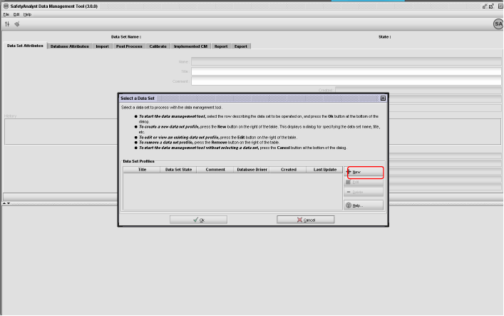
157 147

158 148
159 149

160 150
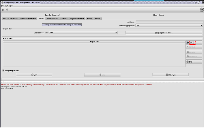
161 151

162 152

163 153

164 154
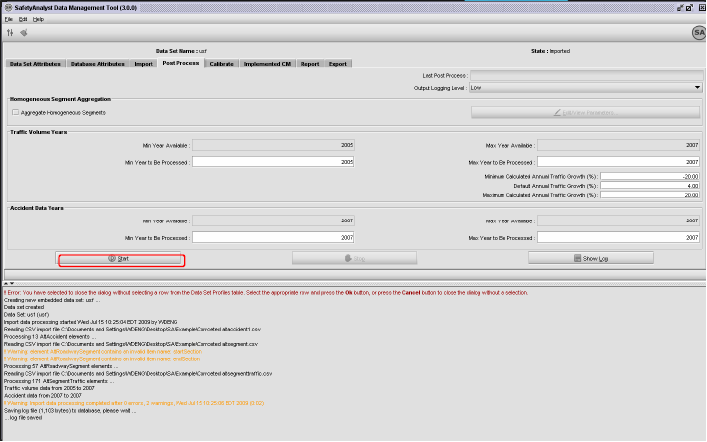
165 155
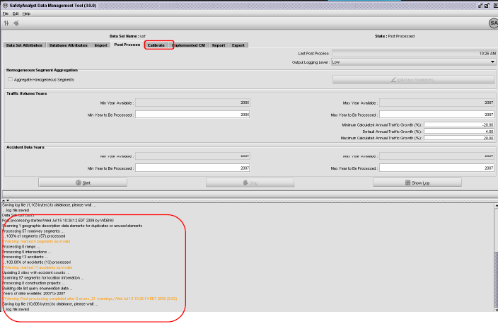
166 156

167 157

168 158
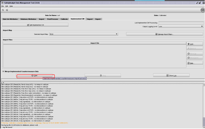
169 159
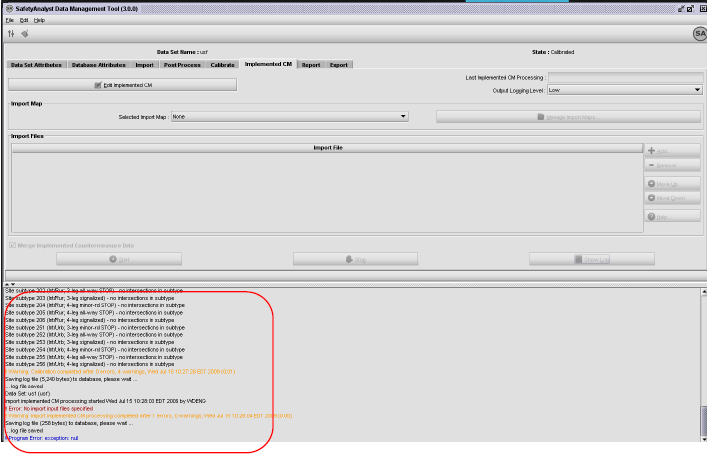
170 160
")
171 APENDIX D SA Analytical Process (This part is the sectional drawing from Safety Analyst) 161
172 162
173 163
174 164
175 165
176 166
177 167
178 168
179 169
180 170
181 171

182 172
183 173

184 174
185 175

186 176

187 177
188 178

189 179
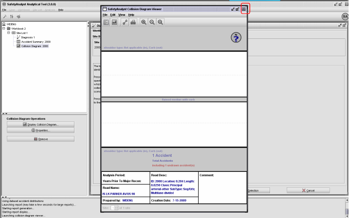
190 180
191 181

192 182
193 183
194 184
195 185
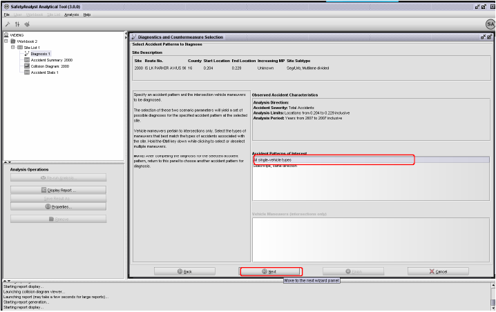
196 186
197 187

198 188

199 189

200 190
201 191
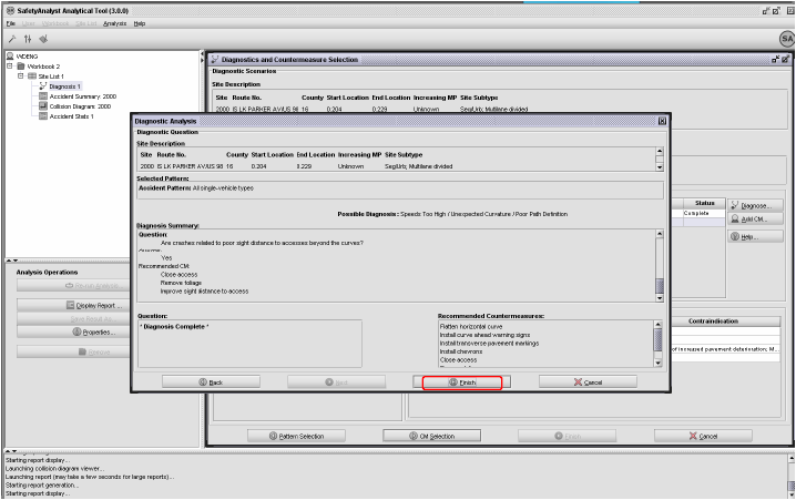
202 192

203 193

204 194

205 195

206 196
207 197

208 198

209 199

210 200
211 201
212 202
213 203

214 204

215 205
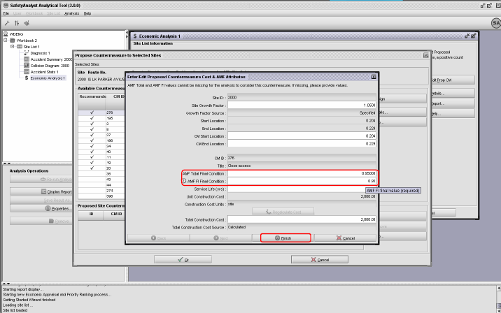
216 206

217 207

218 208
219 209
220 210

221 211

222 212
223 213
224 214
225 215
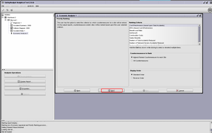
226 216
227 217
228 218
229 219
230 APENDIX E Example of SA Analytical Results (This part is the PDF sectional drawing produced by Safety Analyst) 220
231 221
232 222
233 223
234 224
235 225
236 226
237 227
238 228
239 229
240 230
241 231
242 232
243 233
244 234
245 235
246 236
247 237
248 238
249 239
250 240
251 241
252 242
253 243
254 244
255 245
256 246
257 247
258 248
259 249
260 250
261 251
262 252
263 253
264 254
265 255
266 256
267 257
268 258
269 259
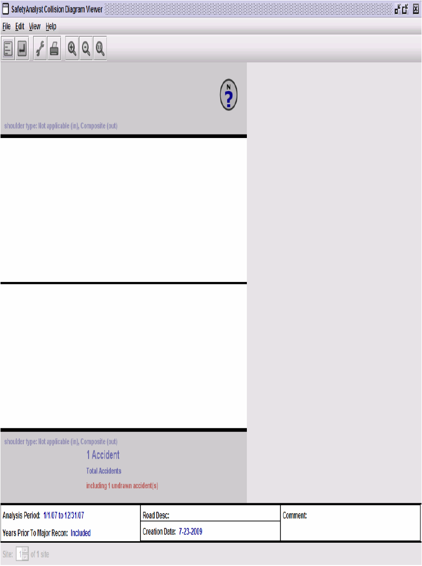
270 260
DEVELOPMENT OF STATEWIDE GIS-BASED FEATURES INVENTORY SYSTEM
 DEVELOPMENT OF STATEWIDE GIS-BASED FEATURES INVENTORY SYSTEM Summary Report 474 Prepared by: Diane Ohde Information Technology Group Arizona Department of Transportation 2739 East Washington Street Phoenix,
Public School Teacher Experience Distribution. Public School Teacher Experience Distribution
 Public School Teacher Experience Distribution Lower Quartile Median Upper Quartile Mode Alabama Percent of Teachers FY Public School Teacher Experience Distribution Lower Quartile Median Upper Quartile
An Analysis of Fatal Large Truck Crashes
 U.S. Department of Transportation National Highway Traffic Safety Administration DOT HS 809 569 June 2003 Technical Report An Analysis of Fatal Large Truck Crashes Published by: National Center for Statistics
Fuel Taxes: December 2012. A State-by-State Comparison
 Fuel Taxes: A -by- Comparison December 2012 The 18th Amendment to the Washington Constitution dedicates motor fuel tax collections to highway purposes. Strategic Planning and Finance Number of s Fuel
Three-Year Moving Averages by States % Home Internet Access
 Three-Year Moving Averages by States % Home Internet Access Alabama Alaska Arizona Arkansas California Colorado Connecticut Delaware Florida Georgia Hawaii Idaho Illinois Indiana Iowa Kansas Kentucky Louisiana
Workers Compensation State Guidelines & Availability
 ALABAMA Alabama State Specific Release Form Control\Release Forms_pdf\Alabama 1-2 Weeks ALASKA ARIZONA Arizona State Specific Release Form Control\Release Forms_pdf\Arizona 7-8 Weeks by mail By Mail ARKANSAS
DOT HS 812 018 April 2014
 TRAFFIC SAFETY FACTS 2012 Data DOT HS 812 018 April 2014 Bicyclists and Other Cyclists In 2012, 726 pedalcyclists were killed and an additional 49,000 were injured in motor vehicle traffic crashes. Pedalcyclist
How does CDOT rank among state DOTs?
 1 Colorado Department of Spring 2014 How does CDOT rank among state DOTs? State transportation departments, the federal government and third-party groups use a variety of metrics to judge the performance
DOT HS 812 101 December 2014. 2013 Motor Vehicle Crashes: Overview 6.00 50,000. Fatality Rate per 100M VMT
 TRAFFIC SAFETY FACTS Research Note DOT HS 812 101 December 2014 2013 Motor Vehicle Crashes: Overview After an increase in motor vehicle crash fatalities in 2012, fatalities on U.S. roadways in 2013 resumed
Chex Systems, Inc. does not currently charge a fee to place, lift or remove a freeze; however, we reserve the right to apply the following fees:
 Chex Systems, Inc. does not currently charge a fee to place, lift or remove a freeze; however, we reserve the right to apply the following fees: Security Freeze Table AA, AP and AE Military addresses*
DOT HS 811 661 August 2012
 DOT HS 811 661 August 2012 State Blood Alcohol Concentration (BAC) Testing and Reporting for Drivers Involved in Fatal Crashes: Current Practices, Results, and Strategies, 1997-2009 DISCLAIMER This publication
Impacts of Sequestration on the States
 Impacts of Sequestration on the States Alabama Alabama will lose about $230,000 in Justice Assistance Grants that support law STOP Violence Against Women Program: Alabama could lose up to $102,000 in funds
BUSINESS DEVELOPMENT OUTCOMES
 BUSINESS DEVELOPMENT OUTCOMES Small Business Ownership Description Total number of employer firms and self-employment in the state per 100 people in the labor force, 2003. Explanation Business ownership
How To Be Safe
 TRAFFIC SAFETY FACTS 2011 Data DOT HS 811 743 April 2013 Bicyclists and Other Cyclists In 2011, 677 pedalcyclists were killed and an additional 48,000 were injured in motor vehicle traffic crashes. Pedalcyclist
MAINE (Augusta) Maryland (Annapolis) MICHIGAN (Lansing) MINNESOTA (St. Paul) MISSISSIPPI (Jackson) MISSOURI (Jefferson City) MONTANA (Helena)
 Maryland (Annapolis) MICHIGAN (Lansing) MINNESOTA (St. Paul) MISSISSIPPI (Jackson) MISSOURI (Jefferson City) MONTANA (Helena)") HAWAII () IDAHO () Illinois () MAINE () Maryland () MASSACHUSETTS () NEBRASKA () NEVADA (Carson ) NEW HAMPSHIRE () OHIO () OKLAHOMA ( ) OREGON () TEXAS () UTAH ( ) VERMONT () ALABAMA () COLORADO () INDIANA
HAWAII () IDAHO () Illinois () MAINE () Maryland () MASSACHUSETTS () NEBRASKA () NEVADA (Carson ) NEW HAMPSHIRE () OHIO () OKLAHOMA ( ) OREGON () TEXAS () UTAH ( ) VERMONT () ALABAMA () COLORADO () INDIANA
How To Know How Many People Die In A Car Crash
 TRAFFIC SAFETY FACTS Research Note DOT HS 811 856 November 2013 2012 Motor Vehicle Crashes: Overview Motor vehicle crashes and fatalities increased in 2012 after six consecutive years of declining fatalities
TRAFFIC SAFETY FACTS. Bicyclists and Other Cyclists. 2009 Data
 TRAFFIC SAFETY FACTS 2009 Data Bicyclists and Other Cyclists For the purpose of this Traffic Safety Fact Sheet, bicyclists and other cyclists include riders of two-wheel nonmotorized vehicles, tricycles,
NON-RESIDENT INDEPENDENT, PUBLIC, AND COMPANY ADJUSTER LICENSING CHECKLIST
 NON-RESIDENT INDEPENDENT, PUBLIC, AND COMPANY ADJUSTER LICENSING CHECKLIST ** Utilize this list to determine whether or not a non-resident applicant may waive the Oklahoma examination or become licensed
Traffic Safety Facts 2008 Data
 Traffic Safety Facts 2008 Data Bicyclists and Other Cyclists DOT HS 811 156 Bicyclists and other cyclists include riders of two-wheel nonmotorized vehicles, tricycles, and unicycles powered solely by pedals.
State Specific Annuity Suitability Requirements updated 10/10/11
 Alabama Alaska Ai Arizona Arkansas California This jurisdiction has pending annuity training legislation/regulation Initial 8 Hour Annuity Training Requirement: Prior to selling annuities in California,
Consent to Appointment as Registered Agent
 Consent to Appointment as Registered Agent This form is used by the person or business entity that agrees to act as the registered agent for a limited liability company. Every person or business entity
Summary Chart of Key Provisions of State Motorcycle Safety Laws
 State Alabama 1 Law Universal Requirements All cabs more more than 4 Alaska Age-specific Included Younger than 18 more than $300 / Arizona Age-specific Younger than 18 more than $250 Arkansas Age-specific
Liquor Wine Beer Other taxes
 6-Feb-5 State Alcohol Excise Tax Rates 205 State Tax Rate ($ per gallon) Sales tax applied? Liquor Wine Beer Tax Rate Sales tax Tax Rate Sales tax ($ per gallon) applied? ($ per gallon) applied? Alabama
STATE-SPECIFIC ANNUITY SUITABILITY REQUIREMENTS
 Alabama Alaska Arizona Arkansas California This jurisdiction has pending annuity training legislation/regulation Annuity Training Requirement Currently Effective Initial 8-Hour Annuity Training Requirement:
Englishinusa.com Positions in MSN under different search terms.
 Englishinusa.com Positions in MSN under different search terms. Search Term Position 1 Accent Reduction Programs in USA 1 2 American English for Business Students 1 3 American English for Graduate Students
Net-Temps Job Distribution Network
 Net-Temps Job Distribution Network The Net-Temps Job Distribution Network is a group of 25,000 employment-related websites with a local, regional, national, industry and niche focus. Net-Temps customers'
States Ranked by Alcohol Tax Rates: Beer (as of March 2009) Ranking State Beer Tax (per gallon)
 Ranking State Beer Tax (per gallon)") States Ranked by Alcohol Tax Rates: Beer (as of March 2009) Ranking State Beer Tax (per gallon) Sales Tax Applied 1 Wyoming $0.02 4% 2 4 8 10 Missouri $0.06 4.225% Wisconsin $0.06 5% Colorado $0.08 2.9%
States Ranked by Alcohol Tax Rates: Beer (as of March 2009) Ranking State Beer Tax (per gallon) Sales Tax Applied 1 Wyoming $0.02 4% 2 4 8 10 Missouri $0.06 4.225% Wisconsin $0.06 5% Colorado $0.08 2.9%
Traffic Safety Facts. Alcohol-Impaired Driving. 2013 Data. Overview. Key Findings
 Traffic Safety Facts 2013 Data December 2014 DOT HS 812 102 Alcohol-Impaired Driving Key Findings There were 10,076 fatalities in 2013 in crashes involving a driver with a BAC of.08 or higher; this was
What to Know About State CPA Reciprocity Rules. John Gillett, PhD, CPA Chair, Department of Accounting Bradley University, Peoria, IL
 What to Know About State CPA Reciprocity Rules Paul Swanson, MBA, CPA Instructor of Accounting John Gillett, PhD, CPA Chair, Department of Accounting Kevin Berry, PhD, Assistant Professor of Accounting
TRAFFIC SAFETY FACTS. Alcohol-Impaired Driving. 2009 Data
 TRAFFIC SAFETY FACTS 2009 Data Alcohol-Impaired Driving DOT HS 811 385 In 2009, there were 10,839 fatalities in crashes involving a driver with a BAC of.08 or higher 32 percent of total traffic fatalities
State Pest Control/Pesticide Application Laws & Regulations. As Compiled by NPMA, as of December 2011
 State Pest Control/Pesticide Application Laws & As Compiled by NPMA, as of December 2011 Alabama http://alabamaadministrativecode.state.al.us/docs/agr/mcword10agr9.pdf Alabama Pest Control Alaska http://dec.alaska.gov/commish/regulations/pdfs/18%20aac%2090.pdf
Traffic Safety Facts 2008 Data
 Traffic Safety Facts 2008 Data Alcohol-Impaired Driving DOT HS 811 155 In 2008, there were 11,773 fatalities in crashes involving a driver with a BAC of.08 or higher 32 percent of total traffic fatalities
DOT HS 811 700 December 2012
 TRAFFIC SAFETY FACTS 2011 Data DOT HS 811 700 December 2012 Alcohol-Impaired Driving Drivers are considered to be alcohol-impaired when their blood alcohol concentration (BAC) is.08 grams per deciliter
DOT HS 811 870 December 2013
 TRAFFIC SAFETY FACTS 2012 Data DOT HS 811 870 December 2013 Alcohol-Impaired Driving Drivers are considered to be alcohol-impaired when their blood alcohol concentration (BAC) is.08 grams per deciliter
The Effect of Increased Speed Limits in the Post-NMSL Era
 Report to Congress The Effect of Increased Speed Limits in the Post-NMSL Era National Highway Traffic Safety Administration Federal Highway Administration U. S. Department of Transportation Washington,
Cash Rents Methodology and Quality Measures
 ISSN: 2167-129X Cash Rents Methodology and Quality Measures Released August 1, 2014, by the National Agricultural Statistics Service (NASS), Agricultural Statistics Board, United States Department of Agriculture
Hail-related claims under comprehensive coverage
 Bulletin Vol. 29, No. 3 : April 2012 Hail-related claims under comprehensive coverage Claims for hail damage more than doubled in 2011 compared with the previous three years. Hail claims are primarily
High Risk Health Pools and Plans by State
 High Risk Health Pools and Plans by State State Program Contact Alabama Alabama Health 1-866-833-3375 Insurance Plan 1-334-263-8311 http://www.alseib.org/healthinsurance/ahip/ Alaska Alaska Comprehensive
State-Specific Annuity Suitability Requirements
 Alabama Alaska Arizona Arkansas California Colorado Connecticut Delaware District of Columbia Effective 10/16/11: Producers holding a life line of authority on or before 10/16/11 who sell or wish to sell
The Need for Traffic Incident Management
 The Need for Traffic Incident Management With traffic incidents responsible for approximately 50-60% of the congestion delays motorists encounter on the nation s roadways every day, increased roadway capacity
Data show key role for community colleges in 4-year
 Page 1 of 7 (https://www.insidehighered.com) Data show key role for community colleges in 4-year degree production Submitted by Doug Lederman on September 10, 2012-3:00am The notion that community colleges
DOT HS 811 701 December 2012. 2011 Motor Vehicle Crashes: Overview. Fatality Rate per 100M VMT
 TRAFFIC SAFETY FACTS Research Note DOT HS 811 71 December 212 211 Motor Vehicle Crashes: Overview In 211, 32,367 people died in motor vehicle traffic crashes in the United States the lowest number of fatalities
Compulsory Auto Insurance and Financial Responsibility Laws State Reporting Programs
 NATIONAL CONFERENCE OF STATE LEGISLATURES EMPLOYMENT AND INSURANCE PROGRAM Compulsory Auto Insurance and Laws State Reporting Programs 1 Alabama 32-7-6 32-7A-6 2000 32-7A-7 32-7A-7 Alaska 28.20 28.22.011
State Tax Information
 State Tax Information The information contained in this document is not intended or written as specific legal or tax advice and may not be relied on for purposes of avoiding any state tax penalties. Neither
Pedestrian Focus States and Action Plans Keith W. Sinclair Highway Safety Engineer FHWA Resource Center: Safety & Design TST
 Pedestrian Focus States and Action Plans Keith W. Sinclair Highway Safety Engineer FHWA Resource Center: Safety & Design TST June 3, 2009 Pedestrian Focus States and Cities Pedestrians are one of our four
Percent change. Rank Most expensive states Average expenditure Rank Least expensive states Average expenditure
 Page 1 of 7 Auto Insurance AAA s 2010 Your Driving Costs study found that the average cost to own and operate a sedan rose by 4.8 percent to $8,487 per year, compared with the previous year. Rising fuel,
Licensure Resources by State
 Licensure Resources by State Alabama Alabama State Board of Social Work Examiners http://socialwork.alabama.gov/ Alaska Alaska Board of Social Work Examiners http://commerce.state.ak.us/dnn/cbpl/professionallicensing/socialworkexaminers.as
Motorcycle ABS and time to claim
 Bulletin Vol. 29, No. 4 : April 2012 Motorcycle ABS and time to claim Antilock braking systems (ABS) have previously been shown to reduce motorcycle collision claim frequencies. The current study examines
Lifesavers 2015 J.T. Griffin Chief Government Affairs Officer MADD
 Lifesavers 2015 J.T. Griffin Chief Government Affairs Officer MADD Why All Offender Ignition Interlock Laws? Drunk Driving still accounts for one-third of ALL U.S. traffic fatalities (10,076 in 2013, NHTSA)
DOT HS 811 523 August 2011. Time of Day and Demographic Perspective Of Fatal Alcohol-Impaired-Driving Crashes. Time of Day
 TRAFFIC SAFETY FACTS Research Note DOT HS 811 523 August 2011 Time of Day and Demographic Perspective Of Fatal Alcohol-Impaired-Driving Crashes Alcohol-impaired driving continues to be one of the major
Schedule B DS1 & DS3 Service
 Schedule B DS1 & DS3 Service SCHEDULE B Private Line Data Services DS1 & DS3 Service... 2 DS-1 Local Access Channel... 2 DS-1 Local Access Channel, New Jersey... 2 DS-1 Local Access Channel, Out-of-State...
NAIC Annuity Suitability Requirements by State
 NAIC Annuity Suitability Requirements by Specific Alabama Alaska 10/16/2011 TBD Arizona Arkansas If you obtained a life insurance license prior to 10/16/11, you must complete the NAIC course by 4/16/12.
The Economic Cost of Traffic Congestion in Florida. Final Document Contract FDOT BDK75 977-19 (UF # 00072256)
") August 2010 The Economic Cost of Traffic Congestion in Florida Final Document Contract FDOT BDK75 977-19 (UF # 00072256) Prepared for: Florida Department of Transportation Project Manager J. Darryll Dockstader
August 2010 The Economic Cost of Traffic Congestion in Florida Final Document Contract FDOT BDK75 977-19 (UF # 00072256) Prepared for: Florida Department of Transportation Project Manager J. Darryll Dockstader
2012 Passenger Vehicle PollNutrition and Fatalities in Texas
 TRAFFIC SAFETY FACTS 2012 Data DOT HS 812 070 September 2014 Passenger A passenger vehicle is a motor vehicle weighing less than 10,000 pounds; the category includes passenger cars and light trucks (pickup
J.D. Power Reports: Strong Network Quality Performance Is Key to Higher Customer Retention for Wireless Carriers
 Kw J.D. Power Reports: Strong Network Quality Performance Is Key to Higher Customer Retention for Wireless Carriers Ranks Highest in Wireless Network Quality Performance in All Six Regions WESTLAKE VILLAGE,
American C.E. Requirements
 American C.E. Requirements Alaska Board of Nursing Two of the following: 30 contact hours 30 hours of professional nursing activities 320 hours of nursing employment Arizona State Board of Nursing Arkansas
STATISTICAL BRIEF #273
 STATISTICAL BRIEF #273 December 29 Employer-Sponsored Health Insurance for Employees of State and Local Governments, by Census Division, 28 Beth Levin Crimmel, M.S. Introduction Employees of state and
DOT HS 811 625 August 2012
 TRAFFIC SAFETY FACTS 2010 Data DOT HS 811 625 August 2012 Pedestrians In 2010, 4,280 pedestrians were killed and an estimated 70,000 were injured in traffic crashes in the United States. On average, a
Connecticut s Insurance Industry: Economic Impacts & Contributions
 Connecticut s Insurance Industry: Economic Impacts & Contributions Prepared by: Connecticut Economic Resource Center, Inc. December 2006 2006 Insure Connecticut s Future, Connecticut Insurance and Financial
Per vehicle mile traveled, motorcyclists were more than 26 times more likely than passenger car occupants to die in a traffic crash.
 TRAFFIC SAFETY FACTS 2012 Data DOT HS 812 035 June 2014 Motorcycles In 2012, 4,957 motorcyclists were killed in motor vehicle traffic crashes an increase of 7 percent from the 4,630 motorcyclists killed
NAIC Annuity Suitability Requirements by State
 NAIC Annuity Suitability Requirements by Specific Alabama Alaska 10/16/2011 TBD Arizona Arkansas If you obtained a life insurance license prior to 10/16/11, you must complete the NAIC course by 4/16/12.
2014 INCOME EARNED BY STATE INFORMATION
 BY STATE INFORMATION This information is being provided to assist in your 2014 tax preparations. The information is also mailed to applicable Columbia fund non-corporate shareholders with their year-end
Sample/Excerpts ONLY Not Full Report
 Sample/Excerpts ONLY Not Full Report Contents at a Glance CONTENTS AT A GLANCE... 2 HOME AUTOMATION USA MARKET... 4 DESCRIPTION... 4 KEY BENEFITS... 4 KEYWORDS... 4 REGION-BASED HOME AUTOMATION MARKET
Traffic Safety Facts Research Note
 1 Traffic Safety Facts Research Note DOT HS 811 218 November 2009 Fatal Crashes Involving Summary Fatalities from crashes involving young drivers have accounted for just under one-fifth of all fatalities
Real Progress in Food Code Adoption
 Real Progress in Food Code Adoption August 27, 2013 The Association of Food and Drug Officials (AFDO), under contract to the Food and Drug Administration, is gathering data on the progress of FDA Food
Verizon Wireless Ranks Highest in Wireless Network Quality Performance in Five Regions; AT&T Ranks Highest in One Region
 Reports: Tablet and Mobile Broadband Devices Generate Increased Data Quality Issues as Usage Patterns and Customer Expectations Impact Problem Incidence Ranks Highest in Wireless Network Quality Performance
CCH esign. ProSystem fx Tax
 ProSystem fx Tax CCH esign Introduction allows you to send documents to your clients, employees, and other third parties to securely obtain their electronic signatures. We teamed up with AssureSign to
HERS_IN. HIGHWAY ECONOMIC REQUIREMENTS SYSTEM (for) INDIANA. AASHTO Transportation Estimator Association Conference October 16, 2001
 INDIANA. AASHTO Transportation Estimator Association Conference October 16, 2001") AASHTO Transportation Estimator Association Conference October 16, 2001 HERS_IN HIGHWAY ECONOMIC REQUIREMENTS SYSTEM (for) INDIANA OVERVIEW HERS Background System Planning Tool Development HERS_IN Structure
AASHTO Transportation Estimator Association Conference October 16, 2001 HERS_IN HIGHWAY ECONOMIC REQUIREMENTS SYSTEM (for) INDIANA OVERVIEW HERS Background System Planning Tool Development HERS_IN Structure
Nurse Aide Training Requirements, 2011
 Nurse Aide Training Requirements, 2011 Background Federal legislation (Omnibus Budget Reconciliation Act of 1987) and associated regulations (42 CFR 483.152) require that Medicare- and Medicaid-certified
Intersection Cost Comparison Spreadsheet User Manual ROUNDABOUT GUIDANCE VIRGINIA DEPARTMENT OF TRANSPORTATION
 Intersection Cost Comparison Spreadsheet User Manual ROUNDABOUT GUIDANCE VIRGINIA DEPARTMENT OF TRANSPORTATION Version 2.5 i Virginia Department of Transportation Intersection Cost Comparison Spreadsheet
FACT SHEET. Language Assistance to Persons with Limited English Proficiency (LEP).
.") FACT SHEET Office of Civil Rights Washington, D.C. 20201 (202) 619-0403 Language Assistance to Persons with Limited English Proficiency (LEP). To ensure that persons with limited English skills can effectively
FACT SHEET Office of Civil Rights Washington, D.C. 20201 (202) 619-0403 Language Assistance to Persons with Limited English Proficiency (LEP). To ensure that persons with limited English skills can effectively
Exploring the Impact of the RAC Program on Hospitals Nationwide
 Exploring the Impact of the RAC Program on Hospitals Nationwide Overview of AHA RACTrac Survey Results, 4 th Quarter 2010 For complete report go to: http://www.aha.org/aha/issues/rac/ractrac.html Agenda
Drunk Driving Accident Statistics
 Drunk Driving Accident Statistics Drunk Driving Legal Resources Drunk Driving Laws by State Video - Rights of Injured Drivers Defective Car Products & Parts Steps to Take After a Car Crash Auto Accident
LLC Domestications. Date: March 23, 2015. [LLC Domestication] [March 23, 2015]
![LLC Domestications. Date: March 23, 2015. [LLC Domestication] [March 23, 2015]](/thumbs/27/9699692.jpg "LLC Domestications. Date: March 23, 2015. [LLC Domestication] [March 23, 2015]") Topic: Question by: : LLC Domestications Earl B. Weaver, Jr. Illinois Date: March 23, 2015 Manitoba Corporations Canada Alabama Alaska Arizona Alabama has removed the term domestication from our Code for
Topic: Question by: : LLC Domestications Earl B. Weaver, Jr. Illinois Date: March 23, 2015 Manitoba Corporations Canada Alabama Alaska Arizona Alabama has removed the term domestication from our Code for
2009-10 STATE AND LOCAL GOVERNMENT TAX AND REVENUE RANKINGS. By Jacek Cianciara
 2009-10 STATE AND LOCAL GOVERNMENT TAX AND REVENUE RANKINGS By Jacek Cianciara Wisconsin Department of Revenue Division of Research and Policy December 12, 2012 TABLE OF CONTENTS Key Findings 3 Introduction
Word Count: Body Text = 5,500 + 2,000 (4 Figures, 4 Tables) = 7,500 words
 = 7,500 words") PRIORITIZING ACCESS MANAGEMENT IMPLEMENTATION By: Grant G. Schultz, Ph.D., P.E., PTOE Assistant Professor Department of Civil & Environmental Engineering Brigham Young University 368 Clyde Building Provo,
PRIORITIZING ACCESS MANAGEMENT IMPLEMENTATION By: Grant G. Schultz, Ph.D., P.E., PTOE Assistant Professor Department of Civil & Environmental Engineering Brigham Young University 368 Clyde Building Provo,
2016 Individual Exchange Premiums updated November 4, 2015
 2016 Individual Exchange Premiums updated November 4, 2015 Within the document, you'll find insights across 50 states and DC with available findings (i.e., carrier participation, price leadership, gross
Penalties by State for Driving While Revoked, Suspended or Otherwise Unlicensed
 Penalties by State for Driving While Revoked, Suspended or Otherwise Unlicensed State Citation Penalties Alabama 32-6-19 Misdemeanor.100-$500 fine, additional fine of $50; Possible jail sentence of not
NAIC ANNUITY TRAINING Regulations By State
 Select a state below to display the current regulation and requirements, or continue to scroll down. Light grey text signifies states that have not adopted an annuity training program. Alabama Illinois
TH 23 Access Management Study Richmond to Paynesville
 TH 23 Access Management Study Richmond to Paynesville Prepared For: Minnesota Department of Transportation District 8 Prepared By: Short Elliott Hendrickson Inc. July 2015 Table of Contents I. Introduction...
********************
 THE SURETY & FIDELITY ASSOCIATION OF AMERICA 1101 Connecticut Avenue, N.W., Suite 800 Washington, D. C. 20036 Phone: (202) 463-0600 Fax: (202) 463-0606 Web page: www.surety.org APPLICATION Application
State Individual Income Taxes: Treatment of Select Itemized Deductions, 2006
 State Individual Income Taxes: Treatment of Select Itemized Deductions, 2006 State Federal Income Tax State General Sales Tax State Personal Property Tax Interest Expenses Medical Expenses Charitable Contributions
All-in-One Asset Management Tool
 APEX-RU0781 All-in-One Asset Management Tool Final Report October 2012 Submitted by Mansooreh Mollaghasemi, Ph.D. Chairman and CEO Productivity Apex, Inc 3505 Lake Lynda Drive, Suite 206 Orlando, FL 32817
INDOT 2000-2025 Long Range Plan
 Chapter 9 INDOT 2000-2025 Long Range Plan Highway Needs Analysis Overview The statewide transportation planning process provides for the identification of highway needs through a comprehensive process
State Tax Information
 State Tax Information The information contained in this document is not intended or written as specific legal or tax advice and may not be relied on for purposes of avoiding any state tax penalties. Neither
Library ebook Survey hosted by OverDrive
 Library ebook Survey hosted by OverDrive ebook survey hosted by OverDrive and American and Library American Association Library (ALA) Association (ALA) 1. State of residency: Alabama 0.8% 583 Alaska 0.5%
Real Progress in Food Code Adoption
 Real Progress in Food Code Adoption The Association of Food and Drug Officials (AFDO), under contract to the Food and Drug Administration, is gathering data on the progress of FDA Food Code adoptions by
Driving under the influence of alcohol or
 National Survey on Drug Use and Health The NSDUH Report December 9, 2010 State Estimates of Drunk and Drugged Driving In Brief Combined 2006 to 2009 data indicate that 13.2 percent of persons aged 16 or
DATA EXPRESSION AND ANALYSIS
 NAME Lab Day DATA EXPRESSION AND ANALYSIS LABORATORY 1 OBJECTIVES Understand the basis of science and the scientific method. Understand exponents and the metric system. Understand the metric units of length,
FELONY DUI SYNOPSIS. 46 states have felony DUI. Charts 1 and 2 detail the felony threshold for each of the 46 states analyzed.
 FELONY DUI SYNOPSIS The information in the following charts was compiled by examining the felony DUI laws in all 50 sates and the District of Columbia. The analysis focuses on the felony DUI threshold,
Economic Impact and Variation in Costs to Provide Community Pharmacy Services
 Economic Impact and Variation in Costs to Provide Community Pharmacy Services Todd Brown MHP, R.Ph. Associate Clinical Specialist and Vice Chair Department of Pharmacy Practice School of Pharmacy Northeastern
LPSC Renewable Energy Pilot y RFPs issued by Utility Companies by Order of Commission, November 2010
 Renewable Energy LPSC Renewable Energy Pilot y RFPs issued by Utility Companies by Order of Commission, November 2010 y Searching for various forms of renewable energy and their actual cost in Louisiana
Question for the filing office of Texas, Re: the Texas LLC act. Professor Daniel S. Kleinberger. William Mitchell College of Law, Minnesota
 Topic: Question by: : Question for the filing office of Texas, Re: the Texas LLC act Professor Daniel S. Kleinberger William Mitchell College of Law, Minnesota Date: March 18, 2012 Manitoba Corporations
Attachment A. Program approval is aligned to NCATE and is outcomes/performance based
 Attachment A The following table provides information on student teaching requirements across several states. There are several models for these requirements; minimum number of weeks, number of required
STATE MOTORCYCLE LEMON LAW SUMMARIES
 STATE MOTORCYCLE LEMON LAW SUMMARIES The Federal Lemon Law covers motorcycles and each state also has its own unique Lemon Law. In the chart below, Covered means whether or not a motorcycle is normally
COMPARE NEBRASKA S BUSINESS CLIMATE TO OTHER STATES. Selected Business Costs for Each State. Workers Compensation Rates
 COMPARE NEBRASKA S BUSINESS CLIMATE TO OTHER STATES Selected Business Costs for Each State Workers Compensation Rates Unemployment Insurance Costs Electricity Rates Gas Rates Average Hourly Earnings in
Low-Profit Limited Liability Company (L3C) Date: July 29, 2013. [Low-Profit Limited Liability Company (L3C)] [July 29, 2013]
![Low-Profit Limited Liability Company (L3C) Date: July 29, 2013. [Low-Profit Limited Liability Company (L3C)] [July 29, 2013]](/thumbs/27/11522934.jpg "Low-Profit Limited Liability Company (L3C) Date: July 29, 2013. [Low-Profit Limited Liability Company (L3C)] [July 29, 2013]") Topic: Question by: : Low-Profit Limited Liability Company (L3C) Kevin Rayburn, Esq., MBA Tennessee Date: July 29, 2013 Manitoba Corporations Canada Alabama Alaska Arizona Arkansas California Colorado
Topic: Question by: : Low-Profit Limited Liability Company (L3C) Kevin Rayburn, Esq., MBA Tennessee Date: July 29, 2013 Manitoba Corporations Canada Alabama Alaska Arizona Arkansas California Colorado
Recruitment and Retention Resources By State List
 Recruitment and Retention Resources By State List Alabama $5,000 rural physician tax credit o http://codes.lp.findlaw.com/alcode/40/18/4a/40-18-132 o http://adph.org/ruralhealth/index.asp?id=882 Area Health
Cancellation/Nonrenewal Surplus Lines Exemptions
 Cancellation/Nonrenewal Surplus Lines Exemptions * Indicates updates in laws or regulations for the state Contact: Tina Crum, tina.crum@pciaa.net, 847-553-3804 Disclaimer: This document was prepared by