en or 20 years ago, planning your life s career meant just that. People tended to learn a relatively narrow set of skills and settle in to a
|
|
|
- Alexander White
- 8 years ago
- Views:
Transcription
1
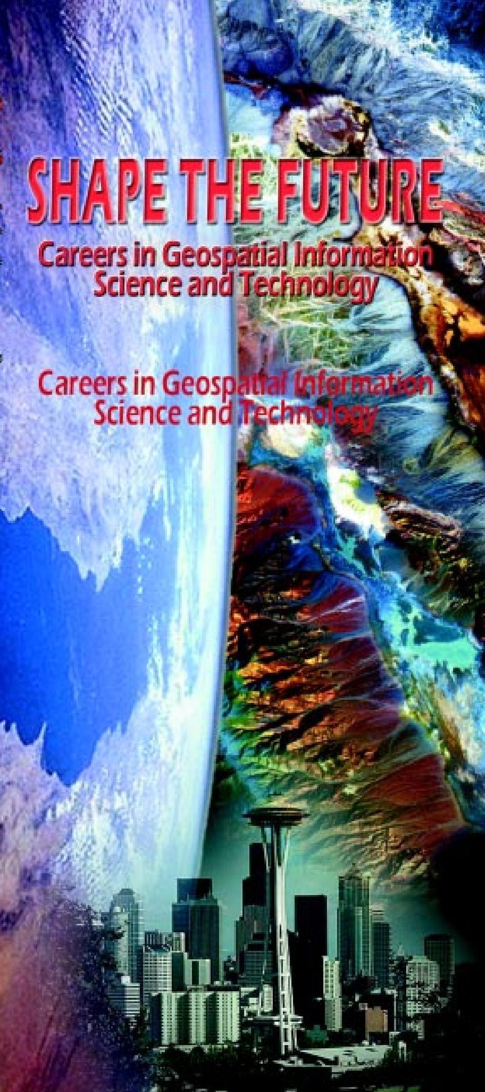
2 en or 20 years ago, planning your life s career meant just that. People tended to learn a relatively narrow set of skills and settle in to a professional life with a simple career path and one or two employers. Today, this traditional employment model still exists, but a current professional career might also involve multiple employment relationships, participation in a virtual organization, self-employment, or pursuit of many types of jobs during one s lifetime. The bottom line in today s world is that it pays to be educated broadly, yet skilled technically, to meet the challenges and reap the tremendous opportunities of an information-based global economy.

3 More and more, this informationbased global economy is becoming a geospatial informationbased economy. Such tools as aerial and satellite remote sensing imagery, the Global Positioning System (GPS), and computerized geographic information systems (GIS) are revolutionizing the conduct of business, science, and government alike. Geospatial information is increasingly becoming the driving force for decision making across the local to global continuum. Tasks as varied as planning urban growth, managing a forest, implementing precision farming, assessing insurance claims, siting an automatic teller machine, routing 911 vehicles, drilling a well, assessing groundwater contamination, designing a cellular phone network, guiding intelligent vehicles, assessing the market for manufactured goods, managing a city, operating a utility, improving wildlife habitat, monitoring air quality, assessing environmental impact, designing a road, studying human health statistics, minimizing water pollution, undertaking real estate transactions, preserving wetlands, mapping natural hazards and disasters, providing famine relief, or studying the causes and consequences of global climate change, can be greatly enhanced by the use of some form of geospatial technology. The pioneers, builders, and specialists in geospatial information collection and management are trained in such fields as photogrammetry, remote sensing, and GIS.

4
5 Photogrammetry Photogrammetry is the tongue-twisting term for the science and technology of obtaining reliable measurements, maps, digital elevation models, and other GIS data primarily from aerial and space photography. Professional photogrammetrists are responsible for all phases of mapping projects and provide spatially accurate base maps that form a foundation for many applications of GIS. Functions can include planning and supervising ground and aerial surveys, interpreting and making measurements from remote sensing imagery, designing maps and cartographic presentations, reproduction and distribution of map products, and managing general business and organizational aspects of photogrammetric projects. Many engineering disciplines also use photogrammetric data as the basis for project planning and design. In order to serve these customers effectively, the professional photogrammetrist must have a broad understanding of a number of civil engineering and GIS disciplines, as well as surveying and geodesy (the study of the true shape of the earth). Some photogrammetrists are employed in the design and manufacturing of specialized data acquisition, analysis, and measurement equipment. As we move into the 21 st century, the photogrammetrist must be well versed in mapping from a variety of source data types: conventional and digital aerial photography, satellite imagery, laser ranging (lidar) and radar to name a few. As a provider of data to a wide variety of users, the photogrammetrist will make professional assessments of the spatial accuracy and integrity of these widely varied data types and will make recommendations for the application of these data in engineering and GIS analysis. w w w. a s p r s. o r g

6 Remote Sensing In a nutshell, remote sensing refers to any technique whereby information about objects and the environment is obtained from a distance. A bat s navigation system is one form of remote sensing. In this case, acoustic waves are used to see objects and determine their position. Remote sensing in the context of obtaining geospatial information is based on measuring variations in how electromagnetic waves interact with objects. The wavelengths typically involved not only include visible light, but also near-infrared, midinfrared, thermal and microwave energy. Hence, remote sensing systems often permit us to greatly expand our spectral view of the earth and see the world much more clearly than we can with the unaided eye or any other sensor restricted to visible wavelengths. Today, an extremely broad range of remote sensing systems are used to collect data from both aerial and spaceborne platforms. These systems include everything from aerial cameras to earth orbiting multispectral sensors, and imaging radar systems. Remote sensing, like photogrammetry and GIS, is a rapidly changing field. Three recent developments in particular are fueling great interest and activity in the field. First, there is substantial research and development underway in the area of hyperspectral remote sensing, which

7 involves systems that sense in literally hundreds of very narrow spectral bands simultaneously. This approach greatly increases the information and detail that can be obtained about objects on the earth s surface. Second, a series of recently launched satellite-borne remote sensing systems form NASA s Earth Observing System (EOS), which is a primary component of the Earth Science Enterprise (ESE). The ESE is an international earth science program aimed at proving the observations, understanding, and modeling capabilities needed to assess the impacts of both natural events and human-induced activities on the earth s environment (
.")
8 A third major influence on the field of remote sensing today is the launch of commercial high-resolution earth-orbiting systems. These systems supply data with a ground sampling distance on the order of 1 meter (3 feet). This will permit objects of approximately one meter in length to be identified on the earth s surface using a satellite in outer space. Most will also be pointable, with their optical systems being controlled by ground command. This will enable frequent observation of areas that are not directly below the satellite and it will also allow the collection of stereoscopic (3D) data. These high-resolution systems are expected to provide a quantum jump in the commercial applications of remote sensing, and hence the demand for professionals in the field. In all, some 45 new satellite remote sensing systems are planned for launch over the next three years ( Remote sensing is a very broadly based field. Professionals with backgrounds in such diverse areas as agriculture, archaeology, business, ecology, engineering, forestry, geography, geology, range management, urban and regional planning, water resources, wetland ecology, wildlife management, manufacturing and machine vision, meteorology, and oceanography use the information processed from remotely sensing data. In addition, many remote sensing scientists are involved in basic research developing new sensor systems, other instruments, and defining new analytical techniques. Many such people are also actively engaged in the area of digital image processing, which is changing rapidly with major improvements in the power of computer systems, networks, and visualization techniques.

9 Geographic Information Systems Geographic Information Systems (GIS) are computerized systems that allow the user to work with, interrelate, and analyze virtually all forms of spatial data. Typically a GIS consists of three major components: a database of geospatial and thematic data and information, a capability to spatially model or analyze the data sets, and a graphical display capability. A GIS synthesizes computer mapping and automated cartography, spatial analysis, data modeling and database management into a coherent unit. GIS enables the combining (overlay) and analysis of various geographicallybased data sets for use in many decision making processes that benefit from the ability to visualize data and information in different ways. GIS emerged as a viable technology in the early 1980s. In the 1990s, it exploded into one of the fastest growing and most widely adopted technologies in the information age. GIS technology also crosscuts many disciplines and applications ranging from the medical profession to natural resource management. Likewise, it spans a diverse group of user communities ranging from small villages to Federal agencies. This exciting technological development integrates remotely sensed and groundbased information into powerful decision making analytical tools. Knowledge and experience is often desirable in one or several application areas such as biology/ ecology, resource management, facilities management, planning, or engineering.
 and analysis of various geographicallybased data sets for use in many decision making processes that benefit from the ability to visualize data and information in")
10 Geographic information systems are used to provide information and knowledge data in various forms to help resolve complex resource questions such as: How does a community best use its natural resources? What is the best location for a highway, given specific environmental, social, and economic constraints? What will be the effect of locating a low-level hazardous waste disposal facility at a certain site? What areas are likely to have the highest soil erosion? What are the likely biological/physical impacts of global warming or ozone depletion? Geographic information systems are also enjoying greatly expanded application in business from siting retail stores, to real estate, logistics, and marketing. Together, photogrammetry, remote sensing, and GIS offer numerous employment opportunities throughout the private, governmental, and academic sectors and across the globe.

11 Educational Background Requirements/ Suggestions College-preparatory courses that emphasize the sciences are suggested for individuals interested in pursuing careers in photogrammetry, remote sensing and GIS. Examples include, but are not limited to, mathematics (algebra, trigonometry, geometry, calculus), biology, chemistry, physics, geography, earth science, computer programming and applications, drafting, English, fine arts/humanities, social studies, and foreign languages. Many 2-year academic and technical institutions offer education and training in photogrammetry, remote sensing and GIS, and in related fields. Associate degree and certificate programs in GIS, surveying, photogrammetry, and similar curricula provide a sound foundation for work experience or for transfer to other academic institutions for further education. There is a substantial demand for technicians in geospatial information technology, for individuals who do not wish to pursue an advanced degree. Majors emphasizing photogrammetry, remote sensing and GIS are typically found in geography, geomatics engineering, civil engineering, forestry, planning, surveying and mapping, or various physical science programs at many colleges and universities, and can result in earning bachelor s, master s, and doctoral degrees. Increasingly, colleges and universities are offering minors, certificates, and specialized professional master s degree programs in these areas as well. Hence, educational preparation can be targeted either toward becoming a specialist in the field of geospatial information science and technology or a specialist in a traditional discipline with a complementary background in photogrammetry, remote sensing, and GIS.

12 It is highly recommended that any individual wishing to pursue a career in photogrammetry, remote sensing, and GIS participate in an internship program to obtain hands-on experience as part of their preparation for employment. Such opportunities are plentiful for those having at least introductory knowledge about geospatial information science and technology. Like many rapidly advancing high-tech fields, continuing education in photogrammetry, remote sensing, and GIS is a must to keep current as a professional. ASPRS: The Imaging & Geospatial Information Society, other professional and scientific organizations, hardware and software providers, and educational institutions offer programs fulfilling this need. Photogrammetry: To qualify as a professional photogrammetrist, you generally need a bachelor s degree, or significant work experience combined with a two-year technical degree in disciplines such as surveying engineering, cartography, or geodesy. While this education generally occurs in engineering curricula, it can also be found in some geography, forestry, or resource management programs. Photogrammetry is a professional discipline newly recognized by the National Council of Examiners for Engineering and Surveying (NCEES). In an increasing number of states it is possible to attain professional status and licensure as a photogrammetric surveyor or mapper. Remote Sensing: A bachelor s or graduate degree is usually required for professional status. Such fields as engineering, physical geography, mathematics, statistics, computer science, and the biological and physical sciences all provide good training for remote sensing. A highly interdisciplinary education often serves as a good foundation for professional work in this field. GIS: Most professionals involved in the GIS field receive an education in the earth sciences, engineering, management, or planning; supplemented with courses in traditional and automated

13 cartography, mapping and remote sensing, spatial statistics, computer science, mathematics, and GIS fundamentals and applications. Where will I find a school that offers these courses? For a sampling of colleges and universities offering programs in GIS, remote sensing, or photogrammetry, see the web sites for the University Consortium for Geographic Information Science ( The Accreditation Board for Engineering and Technology (ABET) evaluates university and college degree programs in surveying, engineering and technology, some of which include imaging and geospatial information discipline areas. Visit their website ( and go to the link on accredited programs for listings of colleges and universities and their ASPRS-related programs. Course catalogs for these institutions will define specific courses for these degree programs. Careers in the Geospatial Sciences Computer Science Biology Geography Physics Geometry Photography Ecology Graphic Arts Forestry Engineering Community Planning Transportation Military Planning Environmental Science Cartography Geodesy Industrial Engineering Civil Engineering Architecture Archeology Urban Planning Agriculture Geology Medicine Aerial Photography Economics Satellite Imagery Meteorology Sociology Hydrology Manufacturing Meteorology Natural Resource Management
 and go to the link on accredited programs for listings of colleges and universities and their ASPRS-related programs.")
14 Employment As mentioned previously, careers in imaging and geospatial technology disciplines are available in nearly all segments of the commercial, public, government, and academic communities. Job titles and starting salaries vary with experience and background. Geographer, cartographer, physical scientist, computer scientist, GIS analyst, database administrator, applications specialist, project manager, remote sensing scientist, surveyor, photogrammetrist, and image analyst, are typical job titles. Detailed information on potential employers in the private sector is available in the special annual issue of Photogrammetric Engineering & Remote Sensing - Resource Book as well as at the ASPRS web site ( The Resource Book lists names and addresses of companies who are Sustaining Members of ASPRS, along with a description of their products and services. State and local government agencies offer opportunities in ASPRS discipline areas. State government activity in these disciplines are generally carried out in agencies such as planning, environment, resources, transportation, and geology, and are usually coordinated through state geographic information councils. The National States Geographic Information Council (NSGIC), which serves as the national coordinating body for these state organizations, can be contacted through links at the NSGIC website ( Employment opportunities in city and county government agencies often parallel state job titles and positions and can be researched at their respective city or county employment offices. Academic institution offerings at the entry level are usually for graduate students at those institutions for teaching assistant or other staff support positions, although instructor positions become available and are widely advertised. World Wide Web searches keyed on locality names and employment yield connections to these opportunities.

15 Many U.S. government agencies, such as the U.S. Geological Survey (USGS), National Oceanic and Atmospheric Administration (NOAA), U.S. Forest Service (USFS), Environmental Protection Agency (EPA), National Aeronautics and Space Administration (NASA), National Imagery and Mapping Agency (NIMA), and U.S. Bureau of Land Management (BLM), offer Federal employment opportunities in related fields. Job announcements and general descriptions of Federal employment opportunities and salary ranges can be found at the U.S. Office of Personnel Management s (OPM) website ( With the increased use of computers in imaging and geospatial technology careers, most jobs are in an office environment. However, certain careers may require extensive field work to verify results or to acquire data in the outdoors. In addition, imaging and geospatial technology disciplines are finding their way into many other applications and careers that are not traditionally associated with photogrammetry, remote sensing, and GIS. For example, photogrammetry is being used in biomedical research, GIS is finding broader use in real estate development, and remote sensing/image processing are being used in law enforcement. Therefore, job titles, alone, are not necessarily the best indication of career opportunities utilizing imaging and geospatial technology. An increasing number of graduates are utilizing GIS in private firms, in environmental management, planning, and other businesses that require spatial analysis. The rise of many more commercial remote sensing firms also is a good opportunity for people with training in geospatial fields. With a bachelor s degree, an employee can expect to obtain an entry-level position working as part of a larger group. With experience, employees can expect to be given more complex responsibilities and will begin to manage larger projects. Those with master s degrees are often expected to assume considerable responsibility as

16 soon as they are hired, including their own projects to manage. In some smaller organizations, employees may be expected to design and implement new imaging and geospatial information procedures and systems. Again, substantial demand exists for technicians in this area to support such activities. For those who earn a doctoral degree (PhD), you could expect to find employment in a university or as a research scientist. The rapid growth of GIS programs at the university level has resulted in a growing market for PhD graduates. There is also a high demand for such individuals with consulting firms, software development firms, and scientific laboratories. Those employers expect you to make significant new contributions to the advancement of current technology, develop new ways to analyze information, or contribute to scientific research, theory, and discoveries. Career Goals Many things lead to a fulfilling career. Monetary reward, ongoing technical challenge, opportunity for advancement, employment flexibility, the development of a local to global perspective, and the satisfaction of truly making a difference all characterize careers in this field. Geospatial information science and technology can provide many commercial, scientific, and social benefits in a broad range of settings. That s why we like to say that when you enter this career area, you not only shape your future, but the future. Check out these web sites for job openings: w w w. a s p r s. o r g
, you could expect to find employment in a university or as a research scientist.")
17 ASPRS: The Imaging & Geospatial Information Society ASPRS is a membership society that represents the interests of individuals and companies in the field of imaging and geospatial information. The mission of ASPRS is to advance knowledge and improve understanding of geospatial information science and technology and to promote the responsible application of photogrammetry, remote sensing, geographic information systems, and supporting technologies. Geospatial information answers the questions who, what, when, and primarily where. ASPRS is committed to providing the highest quality spatial information to all people for effective decision making and better understanding to improve their quality of life. Founded in 1934, ASPRS has given increasing service to the scientific, user communities, and the nation through development of the art and science of photogrammetry, remote sensing and geographic information systems. Scope of Society Interest The core technologies represented by ASPRS are photogrammetry, remote sensing, and geographic information systems (GIS). Supporting technologies include, but are not limited to, cartography, spatial positioning, image processing, and photo interpretation. The Society s integration of core and supporting technologies to real-world applications are currently concentrated in the areas of mapping, environmental and natural resources, modeling, simulation, visualization, close-range imaging, and sociocultural applications. The Society advances responsible practice through its professional certification program, continuing education and workshops, publications, standards, and venues for social and career networking. To find out more about ASPRS and to become a member, visit our web site at

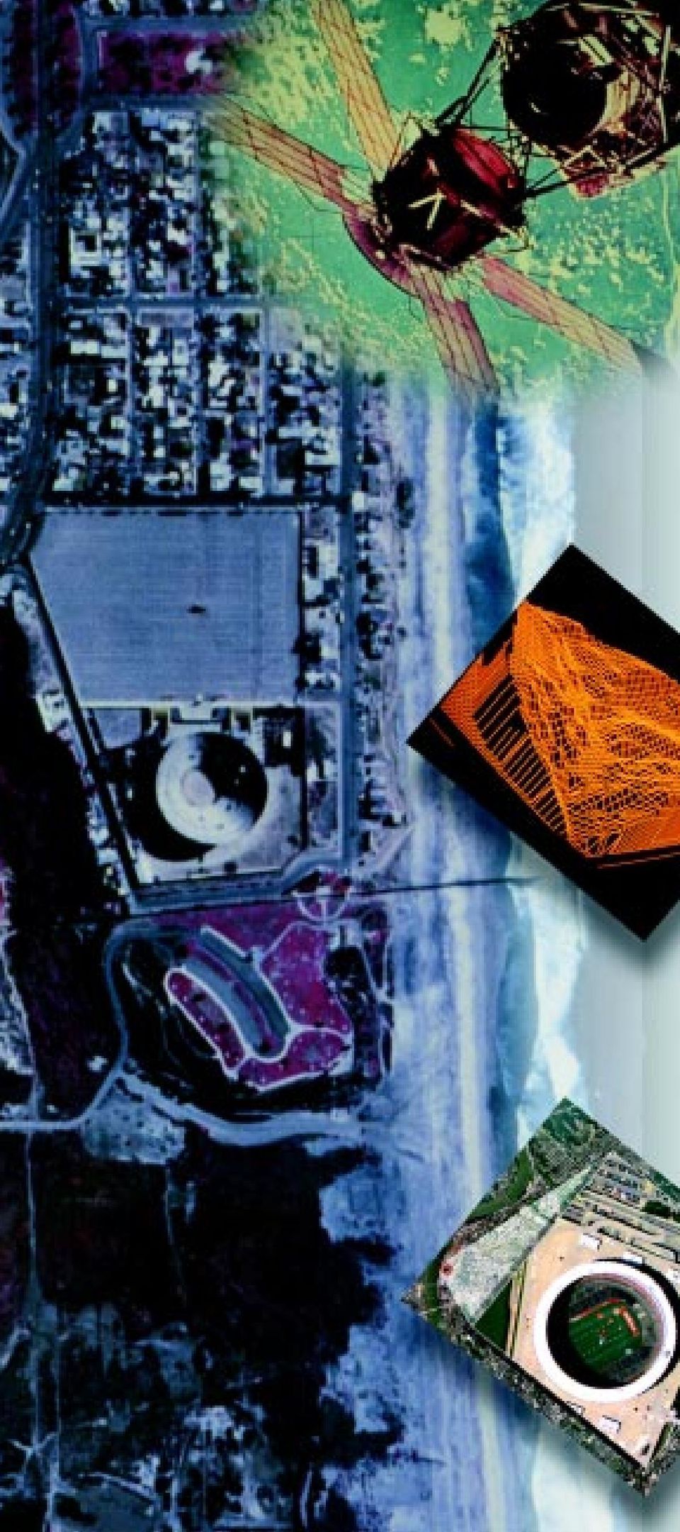
18 Photo Credit This image is a comparison of Landsat Thematic Mapper data on the right and a multipolarization, multifrequency Shuttle Imaging Radar-C (SIR-C) image on the left. The image is of Death Valley National Park, California, USA. Provided by Reasearch Systems, Inc., This image is a color infrared digital orthophoto quadrangle (DOQ) image of Imperial Beach, California and Tijuana, Mexico. Provided by the U.S. Geological Survey (USGS). This image shows an Earth-orbiting satellite carrying remote sensing devices used to acquire, store, and transmit digital images of the Earth s surface. Provided by NASA. This image is a computer rendered perspective view of a digital elevation model, a computer file of regularly-spaced points of elevation on the Earth s surface. Provided by the U.S. Geological Survey (USGS). This image is a GSD natural color collection of the City of Cincinnati taken by Litton/TASC s Emerge Digital Airborne Sensor System. This image is a rendering of 224-band Airborne Visible/Infrared Imaging Spectrometer (AVIRIS) hyperspectral data acquired by the Jet Propulsion Laboratory in the northwest corner of Yellowstone National Park. Provided by Research Systems, Inc. This brochure is downloadable by going to www. asprs.org/career.

. Provided by USGS EROS Data Center.")
19 This image was generated from NASA s Total Ozone Mapping Spectrometer (TOMS), and illustrates the October mean total ozone from and Provided by NASA s Goddard Space Flight Center. This image shows a portion of a 30- meter resolution land-cover data. The primary data source is Landsat thematic mapper (TM). Provided by USGS EROS Data Center. AVIRIS and AIRSAR data acquired by Jet Propulsion Laboratory, processed by Analytical Imaging and Geophysics, Boulder, Colorado using ENVI, the Environment for Visualizing Images as part of a Multi-Mode Image Fusion study sponsored by Eastman Kodak Company. Image provided by Research Systems, Inc. This image depicts data points on contours (lines of equal elevation on the Earth s surface) in a digital elevation data set. Provided by the U.S. Geological Survey (USGS). Terrain features above a specific elevation are shown in shades of green to indicate changes in elevation and slope. This data is merged with a blue-tinted digital orthophoto (a digital photographic image with the characteristics of a map) to show details in areas below that elevation that are subject to flooding. Provided by the U.S. Geological Survey (USGS). All other images provided by This brochure has been sponsored in-part by ERDAS, Inc.

20

DIABLO VALLEY COLLEGE CATALOG 2015-2016
 GEOGRAPHY GEOG Tish Young, Dean Physical Sciences and Engineering Division Physical Sciences Building, Room 263 Possible career opportunities Geography is an interdisciplinary study focusing on the spatial
STATE OF NEVADA Department of Administration Division of Human Resource Management CLASS SPECIFICATION
 STATE OF NEVADA Department of Administration Division of Human Resource Management CLASS SPECIFICATION TITLE PHOTOGRAMMETRIST/CARTOGRAPHER V 39 6.102 PHOTOGRAMMETRIST/CARTOGRAPHER II 33 6.110 PHOTOGRAMMETRIST/CARTOGRAPHER
Digital Remote Sensing Data Processing Digital Remote Sensing Data Processing and Analysis: An Introduction and Analysis: An Introduction
 Digital Remote Sensing Data Processing Digital Remote Sensing Data Processing and Analysis: An Introduction and Analysis: An Introduction Content Remote sensing data Spatial, spectral, radiometric and
Review for Introduction to Remote Sensing: Science Concepts and Technology
 Review for Introduction to Remote Sensing: Science Concepts and Technology Ann Johnson Associate Director ann@baremt.com Funded by National Science Foundation Advanced Technological Education program [DUE
Engineering Disciplines
 Engineering Overview The Field - Engineering Disciplines - Preparation - Accreditation - Day in the Life - Earnings - Employment - Career Path Forecast - Professional Organizations The Field Engineers
OCCUPATIONAL GROUP: Information Technology. CLASS FAMILY: Geographic Information Systems CLASS FAMILY DESCRIPTION:
 OCCUPATIONAL GROUP: Information Technology CLASS FAMILY: Geographic Information Systems CLASS FAMILY DESCRIPTION: This family of positions is a blend which includes those at a Computer Technology level
BSc (Hons) in Geomatics (Surveying & Mapping) DT112
 in Geomatics (Surveying & Mapping) DT112") School of Spatial Planning DEPARTMENT OF SPATIAL INFORMATION SCIENCES BSc (Hons) in Geomatics (Surveying & Mapping) December 2011 HAVE YOU EVER WONDERED? How Sat-Nav systems work? geekanoids.co.uk Imagery
School of Spatial Planning DEPARTMENT OF SPATIAL INFORMATION SCIENCES BSc (Hons) in Geomatics (Surveying & Mapping) December 2011 HAVE YOU EVER WONDERED? How Sat-Nav systems work? geekanoids.co.uk Imagery
BSc (Hons) in Geomatics (Surveying & Mapping) DT112
 in Geomatics (Surveying & Mapping) DT112") School of Spatial Planning DEPARTMENT OF SPATIAL INFORMATION SCIENCES BSc (Hons) in Geomatics (Surveying & Mapping) How Sat-Nav systems work? December 2011 geekanoids.co.uk Imagery by baboom.ie How the
School of Spatial Planning DEPARTMENT OF SPATIAL INFORMATION SCIENCES BSc (Hons) in Geomatics (Surveying & Mapping) How Sat-Nav systems work? December 2011 geekanoids.co.uk Imagery by baboom.ie How the
COASTAL MONITORING & OBSERVATIONS LESSON PLAN Do You Have Change?
 Coastal Change Analysis Lesson Plan COASTAL MONITORING & OBSERVATIONS LESSON PLAN Do You Have Change? NOS Topic Coastal Monitoring and Observations Theme Coastal Change Analysis Links to Overview Essays
Image Analysis CHAPTER 16 16.1 ANALYSIS PROCEDURES
 CHAPTER 16 Image Analysis 16.1 ANALYSIS PROCEDURES Studies for various disciplines require different technical approaches, but there is a generalized pattern for geology, soils, range, wetlands, archeology,
DIABLO VALLEY COLLEGE CATALOG 2016-2017
 Geography GEOGRAPHY GEOG Tish Young, Dean Physical Sciences and Engineering Division Physical Sciences Building, Room 263 Possible career opportunities Geography is an interdisciplinary study focusing
Printer-friendly version (HTML) (PDF)
 (PDF)") Skip Navigation Links Latest Numbers U.S. Department of Labor Bureau of Labor Statistics Occupational Outlook Handbook www.bls.gov Search the Handbook BLS Home OOH Home Frequently Asked Questions A-Z Index
Skip Navigation Links Latest Numbers U.S. Department of Labor Bureau of Labor Statistics Occupational Outlook Handbook www.bls.gov Search the Handbook BLS Home OOH Home Frequently Asked Questions A-Z Index
Active and Passive Microwave Remote Sensing
 Active and Passive Microwave Remote Sensing Passive remote sensing system record EMR that was reflected (e.g., blue, green, red, and near IR) or emitted (e.g., thermal IR) from the surface of the Earth.
GEOLOGY What can I do with this major?
 GEOLOGY What can I do with this major? ENERGY (Oil, Coal, Gas, Other Energy Sources) Geophysics Economic Geology Paleontology Fossil Energy Petroleum industry including oil and gas exploration, production,
GEOGRAPHIC INFORMATION SYSTEMS
 GEOGRAPHIC INFORMATION SYSTEMS WHAT IS A GEOGRAPHIC INFORMATION SYSTEM? A geographic information system (GIS) is a computer-based tool for mapping and analyzing spatial data. GIS technology integrates
It s hard to avoid the word green these days.
 Going green : Environmental jobs for scientists and engineers Alice Ramey Alice Ramey is an economist in the Office of Occupational Statistics and Employment Projections, BLS. She is available at (202)
Pinky Wassenberg, Dean, College of Public Affairs and Administration CPAA College Curriculum Committee
 To: Pinky Wassenberg, Dean, College of Public Affairs and Administration CPAA College Curriculum Committee From: Dennis R. Ruez, Jr., Chair, Department of Environmental Studies Date: 28 January 2011 Re:
PHOTOGRAMMETRIC RESEARCH PROJECTS AT MICHIGAN TECH INTEGRATED GEOSPATIAL TECHNOLOGY PROGRAM. elevin@mtu.edu. tellidis@mtu.edu. kvtakala@mtu.
 PHOTOGRAMMETRIC RESEARCH PROJECTS AT MICHIGAN TECH INTEGRATED GEOSPATIAL TECHNOLOGY PROGRAM Eugene Levin a, Ioakeim Tellidis b, Kevin Takala c a Michigan Technological University,1400 Townsend drive, Houghton
KEY WORDS: Geoinformatics, Geoinformation technique, Remote Sensing, Information technique, Curriculum, Surveyor.
 CURRICULUM OF GEOINFORMATICS INTEGRATION OF REMOTE SENSING AND GEOGRAPHICAL INFORMATION TECHNOLOGY Kirsi VIRRANTAUS*, Henrik HAGGRÉN** Helsinki University of Technology, Finland Department of Surveying
RESOLUTION MERGE OF 1:35.000 SCALE AERIAL PHOTOGRAPHS WITH LANDSAT 7 ETM IMAGERY
 RESOLUTION MERGE OF 1:35.000 SCALE AERIAL PHOTOGRAPHS WITH LANDSAT 7 ETM IMAGERY M. Erdogan, H.H. Maras, A. Yilmaz, Ö.T. Özerbil General Command of Mapping 06100 Dikimevi, Ankara, TURKEY - (mustafa.erdogan;
Chapter Contents Page No
 Chapter Contents Page No Preface Acknowledgement 1 Basics of Remote Sensing 1 1.1. Introduction 1 1.2. Definition of Remote Sensing 1 1.3. Principles of Remote Sensing 1 1.4. Various Stages in Remote Sensing
Field Techniques Manual: GIS, GPS and Remote Sensing
 Field Techniques Manual: GIS, GPS and Remote Sensing Section A: Introduction Chapter 1: GIS, GPS, Remote Sensing and Fieldwork 1 GIS, GPS, Remote Sensing and Fieldwork The widespread use of computers
A remote sensing instrument collects information about an object or phenomenon within the
 Satellite Remote Sensing GE 4150- Natural Hazards Some slides taken from Ann Maclean: Introduction to Digital Image Processing Remote Sensing the art, science, and technology of obtaining reliable information
Guidelines for Procurement of Professional Aerial Imagery, Photogrammetry, Lidar and Related Remote Sensor-based Geospatial Mapping Services
 Guidelines for Procurement of Professional Aerial Imagery, Photogrammetry, Lidar and Related Remote Sensor-based Geospatial Mapping Services The following material is considered final and was approved
The USGS Landsat Big Data Challenge
 The USGS Landsat Big Data Challenge Brian Sauer Engineering and Development USGS EROS bsauer@usgs.gov U.S. Department of the Interior U.S. Geological Survey USGS EROS and Landsat 2 Data Utility and Exploitation
The Status of Geospatial Information Management in China
 The Status of Geospatial Information Management in China Submitted by the National Administration of Surveying, Mapping and Geoinformation of China 1. Administration System The National Administration
CRITERIA FOR ACCREDITING ENGINEERING PROGRAMS
 CRITERIA FOR ACCREDITING ENGINEERING PROGRAMS Effective for Evaluations During the 2009-2010 Accreditation Cycle Incorporates all changes approved by the ABET Board of Directors as of November 1, 2008
A quick overview of geographic information systems (GIS) Uwe Deichmann, DECRG <udeichmann@worldbank.org>
 Uwe Deichmann, DECRG <udeichmann@worldbank.org>") A quick overview of geographic information systems (GIS) Uwe Deichmann, DECRG Why is GIS important? A very large share of all types of information has a spatial component ( 80
A quick overview of geographic information systems (GIS) Uwe Deichmann, DECRG Why is GIS important? A very large share of all types of information has a spatial component ( 80
Remote sensing is the collection of data without directly measuring the object it relies on the
 Chapter 8 Remote Sensing Chapter Overview Remote sensing is the collection of data without directly measuring the object it relies on the reflectance of natural or emitted electromagnetic radiation (EMR).
ENVIRONMENTAL MONITORING Vol. I - Remote Sensing (Satellite) System Technologies - Michael A. Okoye and Greg T. Koeln
 System Technologies - Michael A. Okoye and Greg T. Koeln") REMOTE SENSING (SATELLITE) SYSTEM TECHNOLOGIES Michael A. Okoye and Greg T. Earth Satellite Corporation, Rockville Maryland, USA Keywords: active microwave, advantages of satellite remote sensing, atmospheric
REMOTE SENSING (SATELLITE) SYSTEM TECHNOLOGIES Michael A. Okoye and Greg T. Earth Satellite Corporation, Rockville Maryland, USA Keywords: active microwave, advantages of satellite remote sensing, atmospheric
INVESTIGA I+D+i 2013/2014
 INVESTIGA I+D+i 2013/2014 SPECIFIC GUIDELINES ON AEROSPACE OBSERVATION OF EARTH Text by D. Eduardo de Miguel October, 2013 Introducction Earth observation is the use of remote sensing techniques to better
CRITERIA FOR ACCREDITING ENGINEERING PROGRAMS
 CRITERIA FOR ACCREDITING ENGINEERING PROGRAMS Effective for Reviews During the 2013-2014 Accreditation Cycle Incorporates all changes approved by the ABET Board of Directors as of October 27, 2012 Engineering
Assessment Tasks Pass theory exams at > 70%. Meet, or exceed, outcome criteria for projects and assignments.
 CENTRAL OREGON COMMUNITY COLLEGE: GEOGRAPHIC INFORMATION SYSTEM PROGRAM 1 CENTRAL OREGON COMMUNITY COLLEGE Associate Degree Geographic Information Systems Program Outcome Guide (POG) Program Outcome Guide
CRITERIA FOR ACCREDITING ENGINEERING PROGRAMS
 CRITERIA FOR ACCREDITING ENGINEERING PROGRAMS Effective for Evaluations During the 2011-2012 Accreditation Cycle Incorporates all changes approved by the ABET Board of Directors as of October 30, 2010
12345 El Monte Road Los Altos Hills, California 94022 650.949.7777
 12345 El Monte Road Los Altos Hills, California 94022 650.949.7777 Geospatial Technology Occupations Report for Greater Bay Area Region (Alameda, Contra Costa, Marin, Napa, San Francisco, San Mateo, Santa
WHAT IS GIS - AN INRODUCTION
 WHAT IS GIS - AN INRODUCTION GIS DEFINITION GIS is an acronym for: Geographic Information Systems Geographic This term is used because GIS tend to deal primarily with geographic or spatial features. Information
CRITERIA FOR ACCREDITING ENGINEERING PROGRAMS
 CRITERIA FOR ACCREDITING ENGINEERING PROGRAMS Effective for Reviews During the 2012-2013 Accreditation Cycle Incorporates all changes approved by the ABET Board of Directors as of October 29, 2011 Engineering
Selecting the appropriate band combination for an RGB image using Landsat imagery
 Selecting the appropriate band combination for an RGB image using Landsat imagery Ned Horning Version: 1.0 Creation Date: 2004-01-01 Revision Date: 2004-01-01 License: This document is licensed under a
DIPLOMA/MASTER OF GEOGRAPHICAL INFORMATION SYSTEMS AND REMOTE SENSING (MGR)
") UNIVERSITY OF KHARTOUM FACULTY OF GEOGRAPHICAL AND ENVIRONMENTAL SCIENCES DEPARTMENT OF GIS AND CARTOGRAPHY Proposed Program for DIPLOMA/MASTER OF GEOGRAPHICAL INFORMATION SYSTEMS AND REMOTE SENSING (MGR)
UNIVERSITY OF KHARTOUM FACULTY OF GEOGRAPHICAL AND ENVIRONMENTAL SCIENCES DEPARTMENT OF GIS AND CARTOGRAPHY Proposed Program for DIPLOMA/MASTER OF GEOGRAPHICAL INFORMATION SYSTEMS AND REMOTE SENSING (MGR)
BIOSYSTEMS ENGINEERING What can I do with this major?
 BIOSYSTEMS ENGINEERING What can I do with this major? NATURAL RESOURCES Drainage, Irrigation Systems and Water Control Structures Instrumentation and Control Systems Stormwater Management Systems Erosion
Master of Science Degree in Applied Spatial Information Science. An Inter-Disciplinary Degree at Michigan Technological University
 Master of Science Degree in Applied Spatial Information Science An Inter-Disciplinary Degree at Michigan Technological University General Program Description and Characteristics This proposal is to create
Remote Sensing in Natural Resources Mapping
 Remote Sensing in Natural Resources Mapping NRS 516, Spring 2016 Overview of Remote Sensing in Natural Resources Mapping What is remote sensing? Why remote sensing? Examples of remote sensing in natural
THE OHIO STATE UNIVERSITY CIVIL, ENVIRONMENTAL & GEODETIC ENGINEERING
 THE OHIO STATE UNIVERSITY CIVIL, ENVIRONMENTAL & GEODETIC ENGINEERING Graduate Tracks GEOINFORMATION & GEODETIC ENGINEERING Geoinformation and Geodetic Engineering emerged from the scientific framework
INSTITUTE OF HUMAN RESOURSE ADVANCEMENT (IHRA) UNIVERSITY OF COLOMBO. M. Sc. in Geoinformatics 2014/2015
 UNIVERSITY OF COLOMBO. M. Sc. in Geoinformatics 2014/2015") INSTITUTE OF HUMAN RESOURSE ADVANCEMENT (IHRA) UNIVERSITY OF COLOMBO Introduction M. Sc. in Geoinformatics 2014/2015 Course Conducted by the -IHRA, University of Colombo The Master of Science in Geoinformatics
INSTITUTE OF HUMAN RESOURSE ADVANCEMENT (IHRA) UNIVERSITY OF COLOMBO Introduction M. Sc. in Geoinformatics 2014/2015 Course Conducted by the -IHRA, University of Colombo The Master of Science in Geoinformatics
What can I do with a degree in... Engineering
 What can I do with a degree in... Engineering The Department of Physics offers a spectrum of courses reflective of both the integral character of physics in the liberal arts curriculum and its essential
The Use of Geographic Information Systems in Risk Assessment
 The Use of Geographic Information Systems in Risk Assessment With Specific Focus on the RiVAMP Methodology Presented by Nadine Brown August 27, 2012 Climate Studies Group Mona Climate Change Workshop Presentation
Master of Engineering. Master of Science Civil Engineering
 eb Master of Engineering Geographic Information Systems Specialty Master of Science Civil Engineering Geographic Information Systems Specialty Students seeking an advanced degree with a specialty in Geographic
OVERVIEW AND BACKGROUND GEOGRAPHICAL INFORMATIONS SYSTEMS at the Missouri University of Science & Technology
 OVERVIEW AND BACKGROUND GEOGRAPHICAL INFORMATIONS SYSTEMS at the Missouri University of Science & Technology U.S. Geological Survey Mid-Continent Mapping Center and National Imaging and Mapping Agency-St
How To Teach Engineering
 CRITERIA FOR ACCREDITING ENGINEERING PROGRAMS Effective for Reviews During the 2015-2016 Accreditation Cycle Incorporates all changes approved by the ABET Board of Directors as of November 1, 2014 Engineering
Student Loan Game Plan Your Choices. Your Success.
 Student Loan Game Plan Your Choices. Your Success. Student s Guide to Borrowing Levels by Major When you re reviewing your financial aid award letter and applying for a loan, it s easy to focus only on
U.S. Geological Survey Earth Resources Operation Systems (EROS) Data Center
 Data Center") U.S. Geological Survey Earth Resources Operation Systems (EROS) Data Center World Data Center for Remotely Sensed Land Data USGS EROS DATA CENTER Land Remote Sensing from Space: Acquisition to Applications
U.S. Geological Survey Earth Resources Operation Systems (EROS) Data Center World Data Center for Remotely Sensed Land Data USGS EROS DATA CENTER Land Remote Sensing from Space: Acquisition to Applications
GEOGRAPHY. Geography Degree. Geographic Information Systems (GIS) Degree
 Degree") GEOGRAPHY Area: Science and Engineering Dean: Dr. Rina Roy Assistant Dean: Dr. Derrick Booth Phone: (916) 484-8107 Counseling: (916) 484-8572 Geography Degree The A.S. degree provides students with a solid
GEOGRAPHY Area: Science and Engineering Dean: Dr. Rina Roy Assistant Dean: Dr. Derrick Booth Phone: (916) 484-8107 Counseling: (916) 484-8572 Geography Degree The A.S. degree provides students with a solid
Technology Trends In Geoinformation
 Technology Trends In Geoinformation Dato Prof. Sr Dr. Abdul Kadir Bin Taib Department of Survey and Mapping Malaysia (JUPEM) Email: drkadir@jupem.gov.my www.jupem.gov.my NGIS 2008 3 rd. National GIS Conference
Geospatial Software Solutions for the Environment and Natural Resources
 Geospatial Software Solutions for the Environment and Natural Resources Manage and Preserve the Environment and its Natural Resources Our environment and the natural resources it provides play a growing
MARINE SCIENCE. What can I do with this major?
 MARINE SCIENCE What can I do with this major? BIOLOGICAL OCEANOGRAPHY Ecology and Evolution Conservation Consulting Environmental Protection/Regulation Environmental Remediation/Compliance Fisheries Management
ENVIRONMENTAL STUDIES/SCIENCE What can I do with this degree?
 ENVIRONMENTAL STUDIES/SCIENCE What can I do with this degree? AREAS EMPLOYERS STRATEGIES SOIL SCIENCE Soil and Water Conservation Land Use Waste Disposal Environmental Reclamation of Contaminated Lands
ENVIRONMENTAL SCIENCE MANAGEMENT
 2009-2010 Graduate Bulletin 206 ENVIRONMENTAL SCIENCE MANAGEMENT The Department of Physical and Earth Sciences offers core courses and an area of concentration in environmental science management within
REGIONAL CENTRE FOR TRAINING IN AEROSPACE SURVEYS (RECTAS) MASTER IN GEOINFORMATION PRODUCTION AND MANAGEMENT
 MASTER IN GEOINFORMATION PRODUCTION AND MANAGEMENT") REGIONAL CENTRE FOR TRAINING IN AEROSPACE SURVEYS (RECTAS) MASTER IN GEOINFORMATION PRODUCTION AND MANAGEMENT PROGRAMME DESCRIPTION October 2014 1. The programme The academic programme shall be referred
REGIONAL CENTRE FOR TRAINING IN AEROSPACE SURVEYS (RECTAS) MASTER IN GEOINFORMATION PRODUCTION AND MANAGEMENT PROGRAMME DESCRIPTION October 2014 1. The programme The academic programme shall be referred
A GIS helps you answer questions and solve problems by looking at your data in a way that is quickly understood and easily shared.
 A Geographic Information System (GIS) integrates hardware, software, and data for capturing, managing, analyzing, and displaying all forms of geographically referenced information. GIS allows us to view,
GIS and Remote Sensing in Diachronic Study of Agriculture in Greece
 GIS and Remote Sensing in Diachronic Study of Agriculture in Greece Maria Androulidaki a, Michail Salampasis b, Vagis Samathrakis c, Christos Batzios d a Alexander Technology Educational Institute of Thessaloniki,
AERIAL PHOTOGRAPHS. For a map of this information, in paper or digital format, contact the Tompkins County Planning Department.
 AERIAL PHOTOGRAPHS What are Aerial Photographs? Aerial photographs are images of the land taken from an airplane and printed on 9 x9 photographic paper. Why are Aerial Photographs Important? Aerial photographs
National Diploma in Surveying (Level 6) with an optional strand in Mine Surveying Level 6
 with an optional strand in Mine Surveying Level 6") NZQF Ref 0453 Version 7 Page 1 of 17 National Diploma in Surveying (Level 6) with an optional strand in Mine Surveying Level 6 Credits 250 This qualification has been reviewed. The last date to meet the
NZQF Ref 0453 Version 7 Page 1 of 17 National Diploma in Surveying (Level 6) with an optional strand in Mine Surveying Level 6 Credits 250 This qualification has been reviewed. The last date to meet the
Bachelor s. four Year. Degree. Get ahead by working for the State of California! BACHELOR DEGREE. Why not use your
 Why not use your four Year Bachelor s Degree Get ahead by working for the State of California! If you are beginning to think about your career why not go on line and check out the specification describing
CRITERIA FOR ACCREDITING ENGINEERING PROGRAMS
 CRITERIA FOR ACCREDITING ENGINEERING PROGRAMS Effective for Evaluations During the 2007-2008 Accreditation Cycle Incorporates all changes approved by the ABET Board of Directors as of March 17, 2007 Engineering
Adaptation of High Resolution Ikonos Images to Googleearth for Zonguldak Test Field
 Adaptation of High Resolution Ikonos Images to Googleearth for Zonguldak Test Field Umut G. SEFERCIK, Murat ORUC and Mehmet ALKAN, Turkey Key words: Image Processing, Information Content, Image Understanding,
How Landsat Images are Made
 How Landsat Images are Made Presentation by: NASA s Landsat Education and Public Outreach team June 2006 1 More than just a pretty picture Landsat makes pretty weird looking maps, and it isn t always easy
Geography and Cartography
 LIBRARY OF CONGRESS COLLECTIONS POLICY STATEMENTS ±² Collections Policy Statement Index Geography and Cartography Contents I. Scope II. Research Strengths III. Collecting Policy IV. Acquisitions Sources:
MULTIPURPOSE USE OF ORTHOPHOTO MAPS FORMING BASIS TO DIGITAL CADASTRE DATA AND THE VISION OF THE GENERAL DIRECTORATE OF LAND REGISTRY AND CADASTRE
 MULTIPURPOSE USE OF ORTHOPHOTO MAPS FORMING BASIS TO DIGITAL CADASTRE DATA AND THE VISION OF THE GENERAL DIRECTORATE OF LAND REGISTRY AND CADASTRE E.ÖZER, H.TUNA, F.Ç.ACAR, B.ERKEK, S.BAKICI General Directorate
What can I do with this degree?
 What can I do with this degree? ANY ENGINEERING DISCIPLINE Production Sales and Marketing Management Consulting Research and Development Teaching Law AEROSPACE Propulsion Fluid Mechanics Thermodynamics
From Whitehall to orbit and back again: using space in government
 From Whitehall to orbit and back again: using space in government 18 th June 2014 Bristol 25 th June 2014 Liverpool 3 rd July 2014 -Newcastle Space for Smarter Government Programme (ssgp@sa.catapult.org.uk)
Minimum credits required for graduation is 120. Core Degree Requirements (57 credits)
") COLLEGE OF NATURAL RESOURCES AND ENVIRONMENT B.S. Degree in Water: Resources, Policy, and Management Major: Water: Resources, Policy, and Management For Students Graduating in Calendar Year 2016 Department
COLLEGE OF NATURAL RESOURCES AND ENVIRONMENT B.S. Degree in Water: Resources, Policy, and Management Major: Water: Resources, Policy, and Management For Students Graduating in Calendar Year 2016 Department
DRAFT (VERSION 1.1 05/05/09) CATALOG NARRATIVE ENVIRONMENTAL STUDIES PROGRAM
 CATALOG NARRATIVE ENVIRONMENTAL STUDIES PROGRAM") DRAFT (VERSION 1.1 05/05/09) CATALOG NARRATIVE ENVIRONMENTAL STUDIES PROGRAM Ellensburg Dean Hall, Room 301 (509) 963-1188 FAX: 509-963-1047 www.cwu.edu/~enst Director Greg Brown, PhD Program Information
DRAFT (VERSION 1.1 05/05/09) CATALOG NARRATIVE ENVIRONMENTAL STUDIES PROGRAM Ellensburg Dean Hall, Room 301 (509) 963-1188 FAX: 509-963-1047 www.cwu.edu/~enst Director Greg Brown, PhD Program Information
Department of Geology
 Department of Geology Faculty of Science Brandon University This document is meant as a planning guide only. Students are advised to consult with the Chair of the Department if they have specific questions
MPHIL in GEOGRAPHICAL INFORMATION SYSTEMS AND REMOTE SENSING
 University of Cambridge: Programme Specifications Every effort has been made to ensure the accuracy of the information contained in this programme specification. At the time of publication, the programme
Bachelor Degree In Geography
 In the College of Arts and Letters OFFICE: Storm Hall 323 TELEPHONE: 619-594-5437 / FAX: 619-594-4938 Faculty Emeritus: Blick, Eidemiller, Fredrich, Getis, Greenwood, Griffin, Johnson, Keen, Kiewiet de
STEM Occupations and Salary Information
 STEM s and Salary Information al Outl ook Quarterl y Spri ng 04 www.bls.gov/ooq Table : STEM occupations, by occupational group Management Architectural and engineering managers systems managers Natural
U.S. COMMERCIAL REMOTE SENSING POLICY. April 25, 2003 FACT SHEET
 U.S. COMMERCIAL REMOTE SENSING POLICY April 25, 2003 FACT SHEET The President authorized a new national policy on April 25, 2003 that establishes guidance and implementation actions for commercial remote
DISCIPLINES LIST DIVISION 2
 DISCIPLINES LIST DIVISION 2 DISCIPLINE: AGRICULTURE MASTERS DEGRE REQUIRED Master s in agriculture, agriculture sciences or education with a specialization In agriculture or other agriculture area (including
Student Loan Game Plan Your Choices. Your Success.
 Student Loan Game Plan Your Choices. Your Success. All About Your Success Student s Guide to Borrowing Levels by Major When you re reviewing your financial aid award letter and applying for a loan, think
Joint Polar Satellite System (JPSS)
") Joint Polar Satellite System (JPSS) John Furgerson, User Liaison Joint Polar Satellite System National Environmental Satellite, Data, and Information Service National Oceanic and Atmospheric Administration
Joint Polar Satellite System (JPSS) John Furgerson, User Liaison Joint Polar Satellite System National Environmental Satellite, Data, and Information Service National Oceanic and Atmospheric Administration
STEM DEGREES (Degree title name has to be exactly as here) Acoustical Engineering Acoustical Engineering & Music Actuarial Science Aeronautical and
 Acoustical Engineering Acoustical Engineering & Music Actuarial Science Aeronautical and") STEM DEGREES (Degree title name has to be exactly as here) Acoustical Engineering Acoustical Engineering & Music Actuarial Science Aeronautical and Astronautical Engineering Aeronautical Engineering Aeronautical
STEM DEGREES (Degree title name has to be exactly as here) Acoustical Engineering Acoustical Engineering & Music Actuarial Science Aeronautical and Astronautical Engineering Aeronautical Engineering Aeronautical
CRITERIA FOR ACCREDITING ENGINEERING TECHNOLOGY PROGRAMS
 CRITERIA FOR ACCREDITING ENGINEERING TECHNOLOGY PROGRAMS Effective for Reviews During the 2015-2016 Accreditation Cycle Incorporates all changes approved by the ABET Board of Directors as of November 1,
SESSION 8: GEOGRAPHIC INFORMATION SYSTEMS AND MAP PROJECTIONS
 SESSION 8: GEOGRAPHIC INFORMATION SYSTEMS AND MAP PROJECTIONS KEY CONCEPTS: In this session we will look at: Geographic information systems and Map projections. Content that needs to be covered for examination
The Field. Specialty Areas
 Science Technician Overview The Field - Specialty Areas - Preparation - Day in the Life - Earnings - Employment - Career Path Forecast - Professional Organizations The Field Science technicians use the
Program Learning Objectives
 Geographic Information Science, M.S. Majors in Computational Geosciences. 2012-201. Awase Khirni Syed 1 *, Bisheng Yang 2, Eliseo Climentini * 1 s.awasekhirni@tu.edu.sa, Assitant Professor, Taif University,
Pima Regional Remote Sensing Program
 Pima Regional Remote Sensing Program Activity Orthophoto GIS Mapping and Analysis Implementing Agency Pima Association of Governments (Tucson, Arizona area Metropolitan Planning Organization) Summary Through
Resolutions of Remote Sensing
 Resolutions of Remote Sensing 1. Spatial (what area and how detailed) 2. Spectral (what colors bands) 3. Temporal (time of day/season/year) 4. Radiometric (color depth) Spatial Resolution describes how
GEOGRAPHY / GIS DEGREES AND CERTIFICATES. Geography Degree
 GEOGRAPHY / GIS Area: Science and Engineering Dean: Dr. Rina Roy Phone: (916) 484-8107 Counseling: (916) 484-8572 DEGREES AND CERTIFICATES Geography Degree Geography is the science of place and space.
Earth Data Science in The Era of Big Data and Compute
 Earth Data Science in The Era of Big Data and Compute E. Lynn Usery U.S. Geological Survey usery@usgs.gov http://cegis.usgs.gov U.S. Department of the Interior U.S. Geological Survey Board on Earth Sciences
TerraColor White Paper
 TerraColor White Paper TerraColor is a simulated true color digital earth imagery product developed by Earthstar Geographics LLC. This product was built from imagery captured by the US Landsat 7 (ETM+)
Proposal for a Certificate Program in Geographic Information Science
 Proposal for a Certificate Program in Geographic Information Science Version of April 13, 2009 M. O Neal, T. DeLiberty, and B. Hanson Contents 1. Justification 2. Introduction 3. Eligibility and Admission
2003 INTERNATIONAL CONFERENCE AIRPORTS: PLANNING, INFRASTRUCTURE & ENVIRONMENT
 AIRPORTS: PLANNING, INFRASTRUCTURE & ENVIRONMENT AIRBORNE AND SPACEBORNE REMOTE SENSING TERRAIN MAPPING FOR PLANNING AND DESIGN OF TRANSPORTATION INFRASTRUCTURE ASSETS Waheed Uddin Associate Professor
Department of Geography and Environmental Studies Department of Geography and Environmental Studies Geography Bachelor of Arts Minor
 California State University, San Bernardino 1 Department of Geography and Environmental Studies Department of Geography and Environmental Studies Social and Behavioral Sciences Building, Room 327J (909)
Hyperspectral Satellite Imaging Planning a Mission
 Hyperspectral Satellite Imaging Planning a Mission Victor Gardner University of Maryland 2007 AIAA Region 1 Mid-Atlantic Student Conference National Institute of Aerospace, Langley, VA Outline Objective
Consulting careers: A profile of three occupations
 Consulting careers: A profile of three occupations Choosing an industry in which to work is often as important as choosing an occupation. And over the next several years, the best advice for some workers
Geographical Information Systems with Remote Sensing
 SCHOOL OF SCIENCE Geographical Information Systems with Remote Sensing PGDip/MSc Medway Campus www.gre.ac.uk/science Why study this programme? Geographical Information Systems (GIS) and Remote Sensing
ENVI THE PREMIER SOFTWARE FOR EXTRACTING INFORMATION FROM GEOSPATIAL IMAGERY.
 ENVI THE PREMIER SOFTWARE FOR EXTRACTING INFORMATION FROM GEOSPATIAL IMAGERY. ENVI Imagery Becomes Knowledge ENVI software uses proven scientific methods and automated processes to help you turn geospatial
Commercial Price List
 Commercial Price List Effective May 14, 2010 Scope The Labor rates listed herein are based on the calendar year and applicable to Time-and-Material or Firm Fixed Price proposals for the following commercial
The following was presented at DMT 14 (June 1-4, 2014, Newark, DE).
.") DMT 2014 The following was presented at DMT 14 (June 1-4, 2014, Newark, DE). The contents are provisional and will be superseded by a paper in the DMT 14 Proceedings. See also presentations and Proceedings
DMT 2014 The following was presented at DMT 14 (June 1-4, 2014, Newark, DE). The contents are provisional and will be superseded by a paper in the DMT 14 Proceedings. See also presentations and Proceedings
Point Clouds: Big Data, Simple Solutions. Mike Lane
 Point Clouds: Big Data, Simple Solutions Mike Lane Light Detection and Ranging Point Cloud is the Third Type of Data Vector Point Measurements and Contours Sparse, highly irregularly spaced X,Y,Z values