Search and Discovery Article #60049 (2010) Posted April 28, 2010
|
|
|
- Dorcas Theodora Hopkins
- 8 years ago
- Views:
Transcription
1 A Geologic Review of the Mahogany Subsalt Discovery: A Well That Proved a Play* (The Mahogany Subsalt Discovery: A Unique Hydrocarbon Play, Offshore Louisiana**) Holly Harrison 1, Dwight Clint Moore 2, and Peggy Hodgkins 3 Search and Discovery Article #60049 (2010) Posted April 28, 2010 **Adapted from presentation at AAPG Annual Convention, 1995, and from **extended abstract prepared for presentation at GCSSEPM Foundation 16th Annual Research Conference, Salt, Sediment and Hydrocarbons, December 3-6, Extended abstract used with permission of GCSSEPM Foundation whose permission is required for further use. Appreciation is expressed to GCSSEPM Foundation, and to Dr. Norman C. Rosen, Executive Director, for permission to use it in this adaptation. 1 Phillips Petroleum Company, Bellaire, TX; currently BP, Houston, TX (harrishl@bp.com) 2 Anadarko Petroleum Corporation, Houston, TX; currently ION Geophysical Corporation, Houston, TX (clint@clintmoore.com) 3 Amoco Production Research, Tulsa, OK; currently Veritas Hampson-Russell, Calgary, AB (peggy_hodgkins@cggveritas.com) Abstract The Mahogany subsalt discovery of Phillips Petroleum Company, in partnership with Anadarko Petroleum Corporation and Amoco Production Company, is the petroleum industry's first commercial subsalt oil development in the Gulf of Mexico. Located 80 miles offshore Louisiana on Ship Shoal Blocks 349 and 359, the Mahogany #1 (OCS-G-12008) was drilled in 375 ft of water to a depth of 16,500 ft and tested both oil and gas below an allochthonous salt sheet. The discovery well tested 7256 BOPD and 7.3 MMCFD on a 32/64" choke at 7063 PSI flowing tubing pressure (FTP). The #2 delineation well (OCS-G-12008) was drilled from the same surface location to a depth of 19,101 ft MD (18,572 ft TVD). A different zone in this well was tested in July, 1994, and flowed 4366 BO and MMCFD on a 20/64 choke at 6287 PSI FTP. These flow rates suggest that high sustainable production rates can be expected, and they are confirmed by rock property studies and detailed well log analysis. A third well (OCS-G #2) was spud in September, The primary subsalt reservoir is a high-pressured oil sand with high permeability and porosity and has tremendous deliverability. The field is located 80 miles offshore Louisiana on Ship Shoal South Additions blocks 349/359. The structure is interpreted as a faulted anticline overlain by allochthonous salt. Prestack depth-migrated 3-D seismic data was integrated into a regional geologic model that was based on 2- D time-migrated data. Regionally, the area is characterized by multiple salt sheets, which form a salt canopy sutured east of Mahogany, and several older and deeper sheets are also identified. Structural and rheological aspects of the thick salt sill have been addressed using selected examples of rotary sidewall cores and data on an anomalous "gumbo" shale immediately below the salt which contributes to the understanding of lateral variations at the base of the allochthonous salt. Copyright AAPG. Serial rights given by author. For all other rights contact author directly.

2 Subsalt depositional fairways can be approximated by mapping relative salt-induced paleo-bathymetry. Deepwater sand fairways are closely related to salt movements and extend under the salt sheets. Depositional environments and reservoir parameters in productive sandstone intervals have been defined using whole core and well log imaging. Used with permission of GCSSEPM Foundation whose permission is required for further use.

3

4
5
6
7

8

9
10
11
12

13

14

15

16
17
18
19
20
21
22
23
24
25
26
27
28
29
30
31
32
33
34
35
36
37
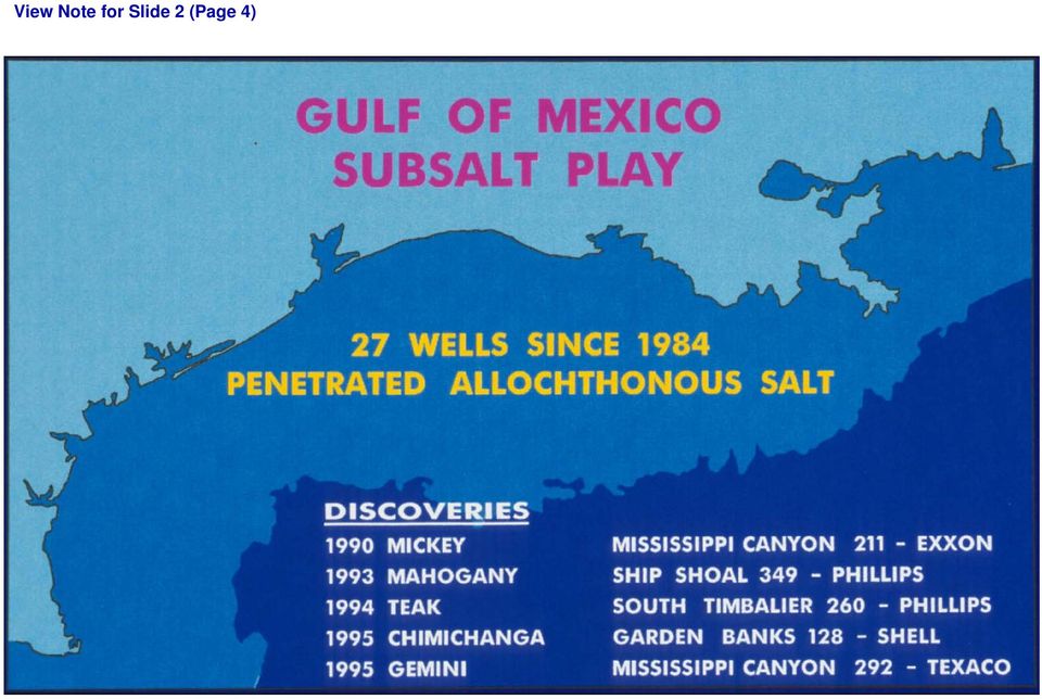
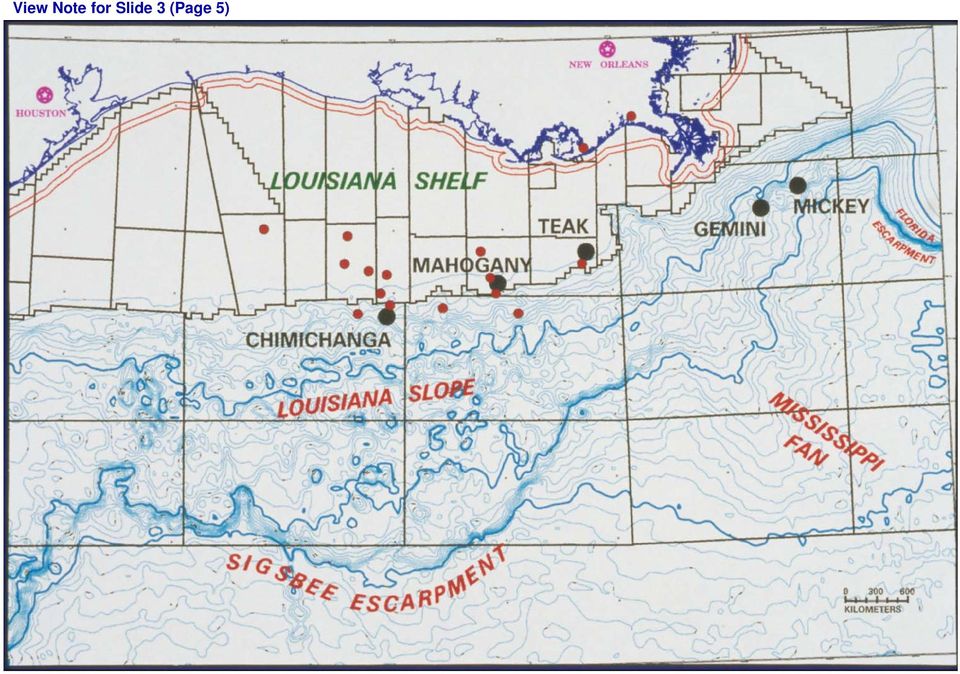
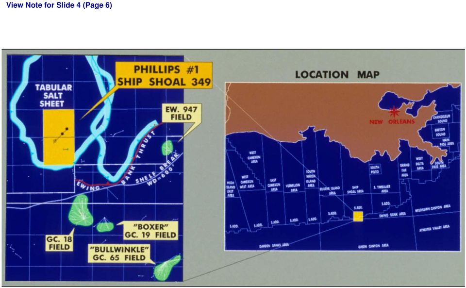
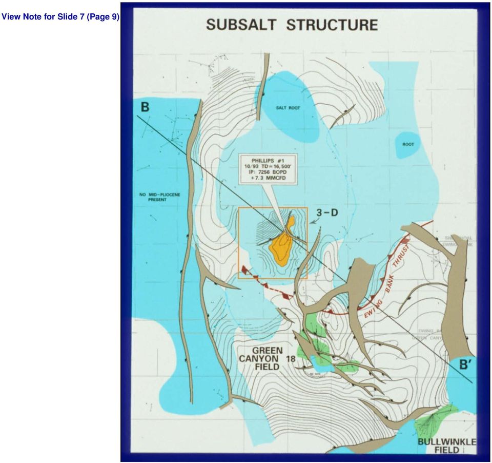
38 Notes Accompanying Slides Slide 1 (Page 3) Although the subsalt play in the Gulf has been active since the early 1980s, it was the Mahogany discovery in 1993 that sparked activity in the play to new heights. We discuss some of the important geological points of the prospect first from a regional and then from a detailed perspective. Drilled by Phillips as operator and partners Anadarko and Amoco. This is the first subsalt discovery on the shelf in the Gulf of Mexico. Return to Slide 1 (Page 3) Slide 2 (Page 4) To date, 27 wells have been drilled through the allochthonous salt since 1984 (red dots). The first discovery was in Mississippi Canyon 211 by Exxon in This well was in water over 4300 ft deep - on the slope. The Mahogany well also discovered hydrocarbons below salt, but the water depth is significantly shallower (372 ft) - on the shelf. In 1994 Phillips and Anadarko also announced the Teak subsalt oil discovery in 290 ft of water. Currently three significant subsalt wells are operating, two exploration and one delineation. Return to Slide 2 (Page 4) Slide 3 (Page 5) To date, 27 wells have been drilled through the allochthonous salt since 1984 (red dots). The first discovery was in Mississippi Canyon 211 by Exxon in This well was in water over 4300 ft deep - on the slope. The Mahogany well also discovered hydrocarbons below salt, but the water depth is significantly shallower (372 ft) - on the shelf. In 1994 Phillips and Anadarko also announced the Teak subsalt oil discovery in 290 ft of water. Currently three significant subsalt wells are operating, two exploration and one delineation. Return to Slide 3 (Page 5) Slide 4 (Page 6) Mahogany is generally on trend with Bullwinkle, Boxer, and Green Canyon 18 fields. These oil fields produce from Pleistocene and Pliocene slope sands - referred to as the flex trend because of the shelf/slope flexure. Return to Slide 4 (Page 6) Slide 5 (Page 7) Although some wells on top of the sheets had oil and gas shows, these are no significant accumulations above salt. To date, the Mahogany salt sheet has four penetrations, more than any salt sheet in the Gulf. The Ewing Bank thrust is an interesting structural feature related to the salt sheets and will be used in the following slides to orient for you the structure. The Ewing Bank thrust runs the leading edge of the eastern salt sheet. Seismic line A-A is a north-south 2-D line that shows the thrust may become listric below salt. Return to Slide 5 (Page 7)
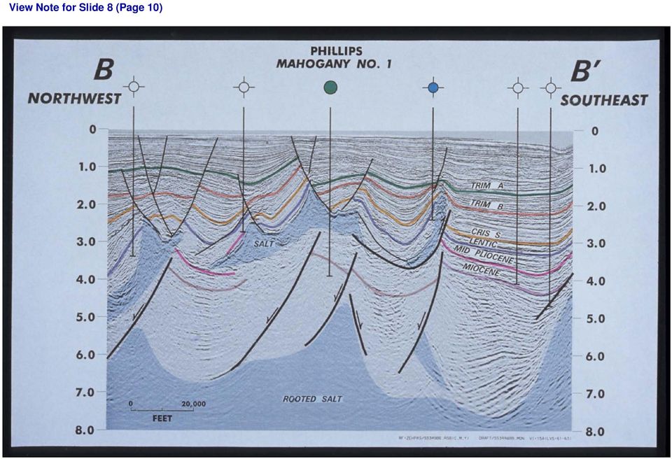
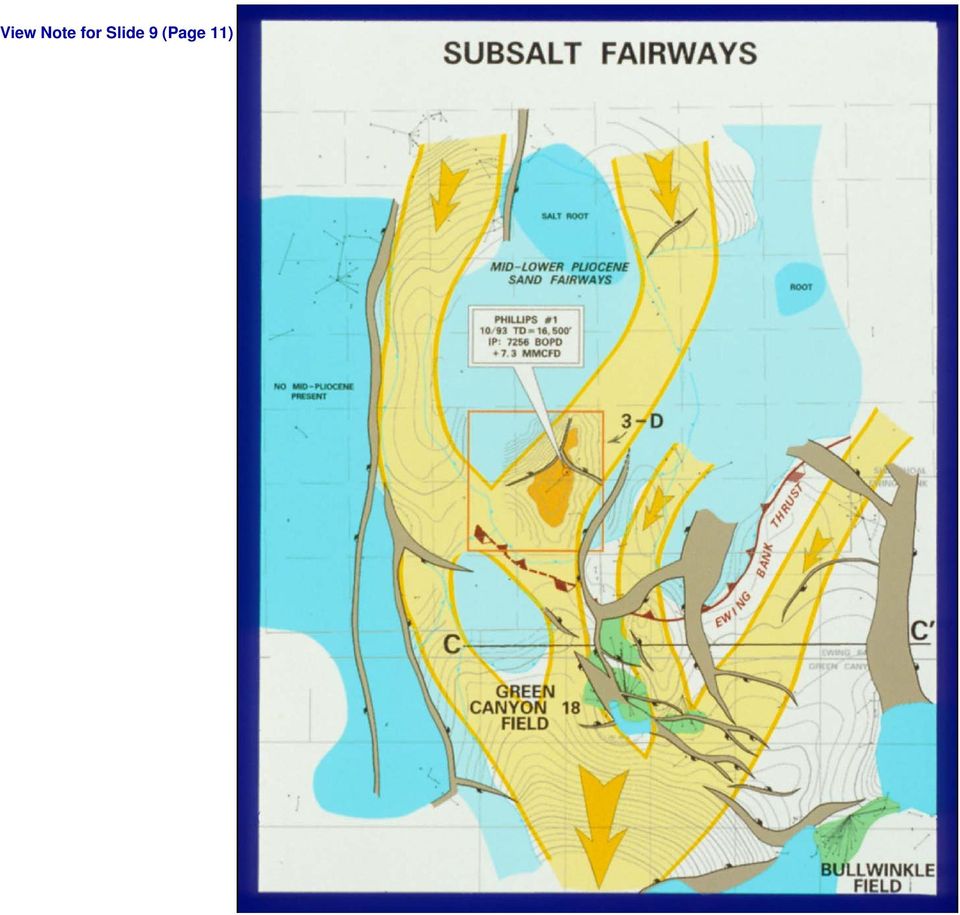
39 Slide 6 (Page 8) The Ewing Bank thrust runs the leading edge of the eastern salt sheet. Seismic line A-A is a north-south 2-D line that shows the thrust may become listric below salt. The area has multiple salt sheets at several depths, implying different emplacement and burial histories. Please note the resolution of large-scale structural features below salt, such as large Pliocene/Miocene basins, deep rooted salt highs, and bounding fault systems. Clearly on this section, the early drilling was mainly for above salt structures and amplitude anomalies, whereas the deeper features were untested. Also important to the subsalt play is recognition of differences between thin-skinned tectonics above salt and deeper thick-skinned tectonics. The structures above and below salt are mostly not linked, but some genetic ties can sometimes be inferred. For example, the imbricate nature of the Ewing Bank thrust system correlates with subsalt highs and lows. The Ewing Bank is a drowned Pleistocene reef that was moved upward into the photic zone by secondary diapirism on the salt sheets. Return to Slide 6 (Page 8) Slide 7 (Page 9) Deep salt features under allochthonous salt on 2-D data can be mapped and tied with regional mapping in the area. Line B-B runs from a deep basin in the SW to a deep basin in the NW. The Ewing Bank thrust terminates along this edge of the salt sheet system and emphasizes the separation of the structures above and below salt. Again, note the shallow well penetrations that test above salt structures only. Return to Slide 7 (Page 9) Slide 8 (Page 10) Line B-B runs from a deep basin in the SW to a deep basin in the NW. The Ewing Bank thrust terminates along this edge of the salt sheet system and emphasizes the separation of the structures above and below salt. Again, note the shallow well penetrations that test above salt structures only. Determination of sedimentary patterns in the deepwater slope environment is a function of paleobathymetric geometry. The deep salt highs will have acted as buttresses and deflected sand deposition as turbidite currents flowed down-slope. Slope sands are therefore sensitive to bathymetry and will concentrate into sand fairways. These two fairways are clear; it is this salt high which is critical to the Mahogany Prospect. The prospect is west of a deep salt high which deflected sand to form a fairway across the acreage. Return to Slide 8 (Page 10) Slide 9 (Page 11) This map shows the probable distribution of sedimentary fairways below the Mahogany salt sheet. The deep salt high (below the salt sheet) funnels sands across the anticline. After sediment deposition, the salt became mobile and flowed down from the north approximately 8-12 miles from the deep source root that fed it, to blanket the structure with allochthonous salt. Return to Slide 9 (Page 11) Slide 10 (Page 12) Line C-C shows the important strike relationships of fairways and deep salt highs. Green Canyon 18 field pay sands are in a younger Pleistocene fairway above a buried salt sheet. However, two older Plio-Miocene fairways flank either side of this younger fairway. The
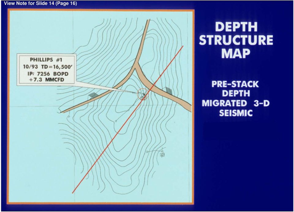
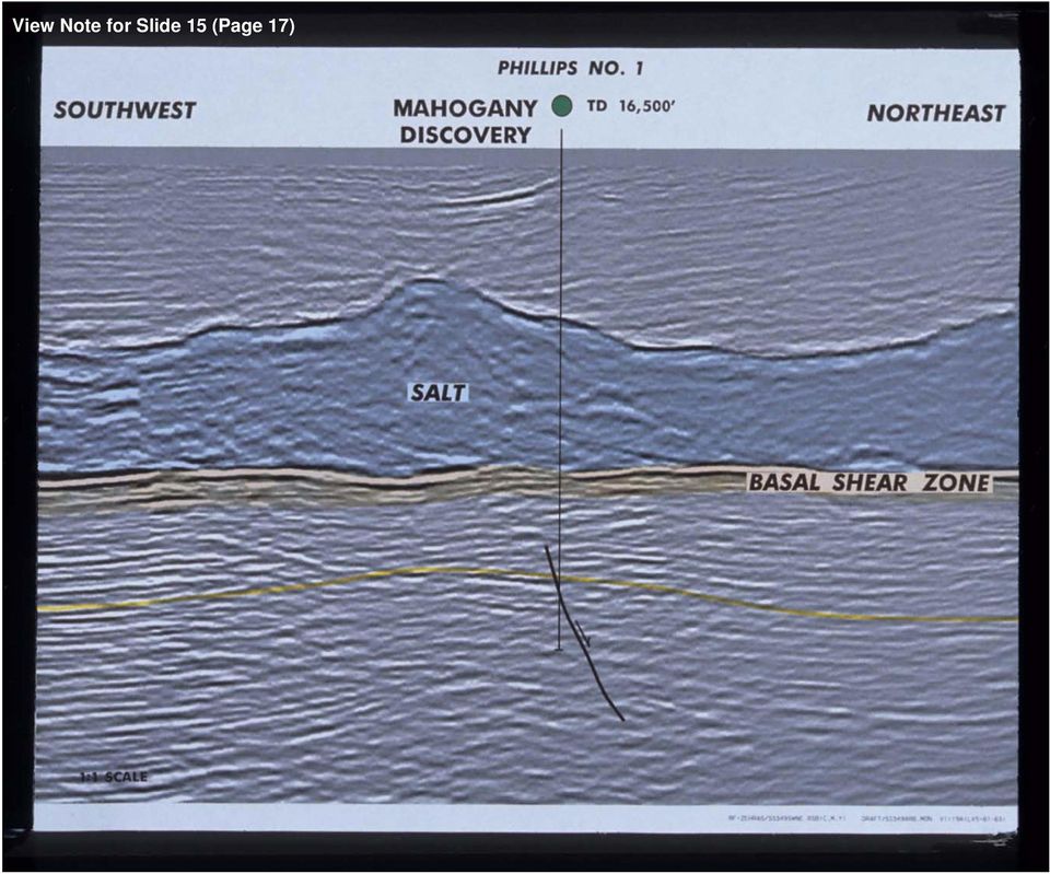
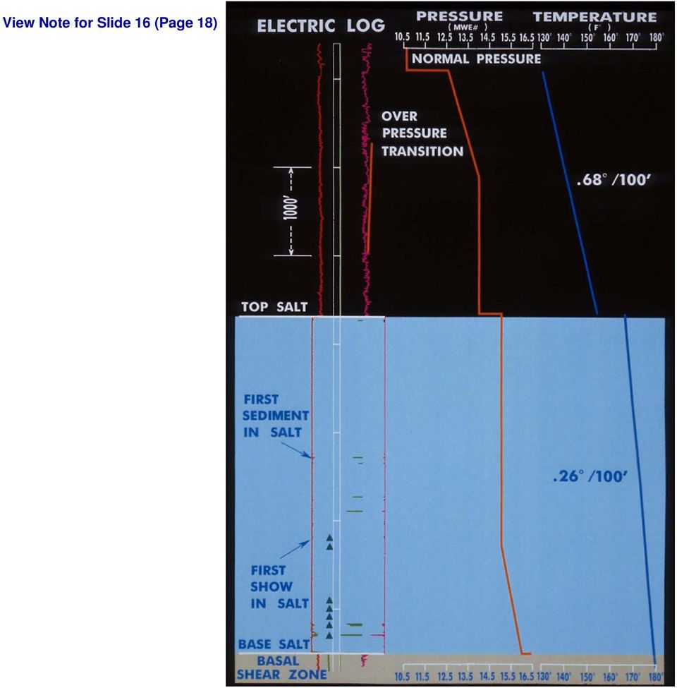
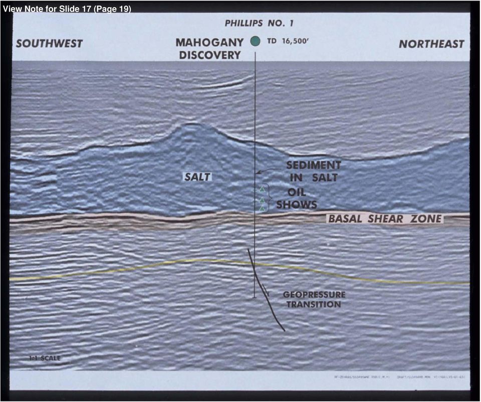
40 western fairway is the key to sand deposition at Mahogany, and can be traced updip under the salt sheet. Return to Slide 10 (Page 12) Slide 11 (Page 13) The regional geologic work was integrated with the localized 3-D seismic depth interpretation seen here. Mahogany is basically a faulted anticline with 3-way dip closure. The discovery well was drilled four miles from the edge of the salt sheet. The detailed structure map shows only a generalized structure and interpretation of new data is ongoing. Also, the distribution of reservoir sand varies across the structure. We now move on to a more detailed picture of the Mahogany Discovery. Return to Slide 11 (Page 13) Slide 12 (Page 14) Structure is anticline bounded on the north by northwest and northeast dipping faults. Line of NW-SE seismic section in Slide 13 (Page 15). Return to Slide 12 (Page 14) Slide 13 (Page 15) In the dip direction, the base of the salt dives to the northwest (towards the original source of the allochthonous salt). The northwest-dipping fault that cuts the anticline is clearly imaged on this data. The top and base of salt are also imaged as well as the secondary diapir formed on this part of the salt sheet. This seismic line and the following line are from a Phillips pre-stack 3-D depth migration and have no vertical exaggeration. Return to Slide 13 (Page 15) Slide 14 (Page 16) Structure is anticline bounded on the north by northwest and northeast dipping faults. Line of NE-SW seismic section in Slide 15 (Page 17). Return to Slide 14 (Page 16) Slide 15 (Page 17) The strike line shows the anticlinal closure to the southwest and the northeast. There are indications of other smaller faults which complicate the structure. The base of salt is more even and gently concave in the strike orientation.. Return to Slide 15 (Page 17) Slide 16 (Page 18) The SS 349 #1 well drilled very little sand above salt. This slide has a electric log, the pore pressures as mud weight per gallon, and temperature. Pressures and temperatures were typical for above salt wells in the area. Sedimentary inclusions within the salt were first encountered halfway through salt which is over 3500 ft thick. The first oil show was 2/3 the way through the sheet. The temperature gradient in the salt was low due to the high thermal conductivity of salt. Rotary sidewall cores were cut in the salt and analyzed for viscosity and
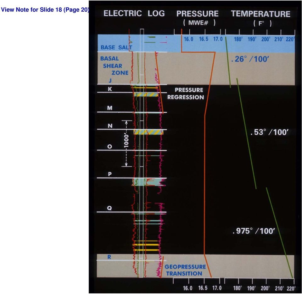
41 strain to help determine salt mobility which can impact long-term casing design. Although salt is an incompressible rock and should have no variations in pore pressure, the sedimentary inclusions within the salt made it necessary to increase mud weights to control gas. Mud weights were also increased in anticipation of the subsalt section. Return to Slide 16 (Page 18) Slide 17 (Page 19) SW-NE seismic line, with annotations about sedimentary inclusions within the salt, the underlying sediments, and pressure regime. SS 349 #1 drilled very little sand above salt. Pressures and temperatures were typical for above salt wells in the area. Sedimentary inclusions within the salt were first encountered halfway through salt which is over 3500 ft thick. The first oil show was 2/3 the way through the sheet. The temperature gradient in the salt was low due to the high thermal conductivity of salt. Return to Slide 17 (Page 19) Slide 18 (Page 20) The well came out into high-pressured gumbo shales below salt, referred to as basal shear zone. This zone, which is typically seen in subsalt wells, has pore pressures that may exceed #17ppg pressure gradients (0.88psi/ft). Pressure gradients regress with depth below the salt sheet back to more regional gradients (although still geopressured). Note the conductivity curve is increasing with decreasing pressure. The shallowest oil sand at Mahogany is the J sand in the pressure transition zone. There are multiple pay zones, but the primary target is the P sand. Water-bearing sands are found just below the J sand and starting in R sand interval. Pressure increases once more near the bottom of the well. Salt has a large temperature halo below and the gradients gradually increase downward from the base of salt. Return to Slide 18 (Page 20) Slide 19 (Page 21) The P sand target interval was flow tested in two stages. DST 1 perforated 28 ft and flowed 3700 BO and 550MCFD on a 14/64 choke at 6800 PSI flowing tubing pressure. Perforations from the base of the sand were then added and the commingled flow rate was 7256 BO and 7.3MMCFD on a 32/64 choke at 7063 PSI flowing tubing pressure. The selective test (DST 1) was across a very low resistivity interval where sensitivities are actually lower than the shales above and below the P sand (0.4 ohms). The lower DST interval has a more typical log response that indicates pay. The total perforated interval was 48 ft out of about 200 ft gross interval. Return to Slide 19 (Page 21) Slide 20 (Page 22) In the P sand, as we know now, the low resistivity pay is caused by fine laminations of shale that alternate with thin sand and silt laminae of higher resistivity. Most logs do not have the vertical resolution to distinguish between the shale and pay sand; they average the responses. Wireline porosity logs (long spaced sonic, litho density, and neturon) also average the shale and sand and cannot resolve low-resistivity pay. The density-neutron logs, for example, have very little crossover in these zones. There IS crossover at the top and base where the resistivity is also higher, and this portion of the P sand calculates as pay. Return to Slide 20 (Page 22)
42 Slide 21 (Page 23) Nuclear Magnetic Resonance data (seen here as a MRIAN log display) can distinguish between ineffective porosity and effective porosity. Processed with resistivity and porosity, the MRIAN log determines the percent of moveable hydrocarbons. This one of two open hole logs than can resolve the pay. Return to Slide 21 (Page 23) Slide 22 (Page 24) On the left is an Array Induction log that is run at 1-ft resolution. However, the tool that defines the nature and cause of the low resistivity pay is the Formation Micro Imager (FMI). This tool has a resolution down to 0.25 and gives a better picture of what causes low resistivity. The FMI reveals a highly laminated interval with discrete shales and sands. The sands are yellow and the silts are orange. Return to Slide 22 (Page 24) Slide 23 (Page 25) This is the FMI images of the P sand interval with the location of percussion sidewall cores (see Slide 28 [Page 30]) and dips. The scale is 10 ft. The average core porosity is 26% (ranging from 18-33%), and permeability is 32% millidarcies (ranging up to 2.5 darcies). The sands at the base are up to 3 ft thick; there is an extensive section of very finely laminated sands, with thicker sand beds at the top. The P sand was deposited in deepwater, and the dip changes indicate multiple episodes of sedimentation. The sequence is probably composed of channels and levee deposits with a thick interval of rippled silt and sand. Return to Slide 23 (Page 25) Slide 24 (Page 26) FMI images of the P sand interval with the section from the lower part of the sand shown in Slide 25 (Page 27) highlighted in red. Return to Slide 24 (Page 26) Slide 25 (Page 27) This is a close-up of the section highlighted with red in Slide 24 (Page 26). The scale is 1 ft. The basal sands (which are relatively thickbedded) have the coarsest grain size seen in the P sand (fine-grained sand). The sands have erosional bases, are either amorphous or fining upward, and contain some shale clasts. These are interpreted as channel sands deposited by density currents. This section was part of the perforated interval that flowed over 7000 BOPD and 7 MMCFD. Now, we move up the section. Return to Slide 25 (Page 27) Slide 26 (Page 28) FMI images of the P sand interval, with part of the section characterized by low resistivity highlighted in red; this is the interval represented by Slide 27 (Page 29). Return to Slide 26 (Page 28)
43 Slide 27 (Page 29) The lowest resistivity section is an extensive sequence of ripple-laminated sand and silt--note that the image has blebby texture. Although porosities and permeabilities are lower than in the channel sands (60-90 md and 25% porosity), the selective DST on this zone flowed 3700 BOPD and 550 MCFD. Return to Slide 27 (Page 29) Slide 28 (Page 30) The two sidewall cores of this interval clearly show the scale of laminations. Position of cores is shown in Slide 23 (Page 25). The FMI can resolve laminations down to 0.25, but the core indicates that even this tool may be too coarse. The scale of the laminations are microscopic. Silt has reasonable permeabilities and porosities. Return to Slide 28 (Page 30) Slide 29 (Page 31) FMI images of P sand; highlighted interval (in red), of section higher in the section characterized by low-resistivity, shows flame structures in shale layers. Detail shown in Slide 30 (Page 32). Return to Slide 29 (Page 31) Slide 30 (Page 32) Moving higher in the section, flame structures in shale layers become more apparent. This interval contains ripple-laminated sands and discrete shale laminations (some sands retain the original ripple geometry). This section is still very highly laminated and has variable dips. Return to Slide 30 (Page 32) Slide 31 (Page 33) FMI images of P sand interval, with highlighted section (in red) of channel and laminated sands that cap the sand. These are shown in more detail in Slide 32 (Page 34). Laminated beds are up to 1 ft thick, but unlike the basal channels this section has very finely laminated sands as well as thicker, featureless channel sands. Return to Slide 31 (Page 33) Slide 32 (Page 34) Channel and laminated sands cap the P sand, where laminated beds are up to 1 ft thick. Unlike the basal channels, however, this section has very finely laminated sands as well as thicker, featureless channel sands. This is a normal resistively pay interval. Overall, the P sand has a fining-upward textural sequence, with a coarse-grained, more thick-bedded layer at the base, overlain by extensive rippled and highly laminated sands. With more core and log data, the areal geometry of the sands can be incorporated into an applicable deepwater depositional model. Return to Slide 32 (Page 34)
44 Slide 33 (Page 35) NW-SE seismic line with position of discovery well and its log, which together provide a visual summary of the play. Return to Slide 33 (Page 35) Slide 34 (Page 36) In summary, the major conclusions about the Mahogany Subsalt Discovery are: It is the first subsalt discovery on the shelf in the Gulf of Mexico. It is a faulted anticline overlain by allochthonous salt. deepwater sand fairways were deposited prior to salt movement, and they extend under the salt sheets. Subsalt reservoirs have tremendous deliverability. They are high-pressure oil sands, have high K and phi (up to 2.5 darcies and 33% porosity), and have exceptional flow rates. Mahogany is also a case study for low-resistivity pays. Some of the pay sands encountered at Mahogany are not defined by standard wireline log suites. The pay can be resolved by Magnetic Resonance logs and imaging tools, such as the FMI. Sand and silt laminae down to 0.25 can be resolved by the FMI, but cores have laminae down to microscopic scale. Return to Slide 34 (Page 36) Slide 35 (Page 37) I would like to acknowledge the interdisciplinary team and intra-company teams that made this exciting work possible--from Phillips, particularly our Bartlesville Seismic Processing, group, and the other contributions from Anadarko and Amoco. Return to Slide 35 (Page 37)
Search and Discovery Article #40256 (2007) Posted September 5, 2007. Abstract
 Posted September 5, 2007. Abstract") Evaluating Water-Flooding Incremental Oil Recovery Using Experimental Design, Middle Miocene to Paleocene Reservoirs, Deep-Water Gulf of Mexico* By Richard Dessenberger 1, Kenneth McMillen 2, and Joseph
Evaluating Water-Flooding Incremental Oil Recovery Using Experimental Design, Middle Miocene to Paleocene Reservoirs, Deep-Water Gulf of Mexico* By Richard Dessenberger 1, Kenneth McMillen 2, and Joseph
EGAS. Ministry of Petroleum
 EGAS Ministry of Petroleum EGAS Ministry of Petroleum About The Block Location: Shorouk offshore block is a part of recent relinquished of NEMED concession previously operated by Shell. It is bounded from
Analysis of GS-11 Low-Resistivity Pay in Main Gandhar Field, Cambay Basin, India A Case Study
 5th Conference & Exposition on Petroleum Geophysics, Hyderabad-2004, India PP 162-166 Analysis of GS-11 Low-Resistivity Pay in Main Gandhar Field, Cambay Basin, India A Case Study Ashok Kumar, J.P. Narayan,
How Did These Ocean Features and Continental Margins Form?
 298 10.14 INVESTIGATION How Did These Ocean Features and Continental Margins Form? The terrain below contains various features on the seafloor, as well as parts of three continents. Some general observations
Petrophysical Well Log Analysis for Hydrocarbon exploration in parts of Assam Arakan Basin, India
 10 th Biennial International Conference & Exposition P 153 Petrophysical Well Log Analysis for Hydrocarbon exploration in parts of Assam Arakan Basin, India Summary Ishwar, N.B. 1 and Bhardwaj, A. 2 *
GAS WELL/WATER WELL SUBSURFACE CONTAMINATION
 GAS WELL/WATER WELL SUBSURFACE CONTAMINATION Rick Railsback Professional Geoscientist CURA Environmental & Emergency Services rick@curaes.com And ye shall know the truth and the truth shall make you free.
Broadband seismic to support hydrocarbon exploration on the UK Continental Shelf
 Broadband seismic to support hydrocarbon exploration on the UK Continental Shelf Gregor Duval 1 1 CGGVeritas Services UK Ltd, Crompton Way, Manor Royal Estate, Crawley, RH10 9QN, UK Variable-depth streamer
ASX ANNOUNCEMENT 17 JUNE 2014
 ASX ANNOUNCEMENT 17 JUNE 2014 Sunbird-1 oil zone verified offshore Kenya Historic first-ever oil column discovered offshore East Africa Sunbird-1 well, completed in March in area L10A, intersected a gross
Securing the future of decom
 R E Q U I R E D R E A D I N G F O R T H E G L O B A L O I L & G A S I N D U S T R Y S I N C E 1 9 7 5 AUGUST 2011 Deep thinking on the Latin American beat Floating production tales of the unexpected OFFSHORE
WELL LOGGING TECHNIQUES WELL LOGGING DEPARTMENT OIL INDIA LIMITED
 WELL LOGGING TECHNIQUES WELL LOGGING DEPARTMENT OIL INDIA LIMITED The Hydrocarbon E & P Process In the exploration process, a most probable hydrocarbon bearing rock structure is defined based on seismic
Search and Discovery Article #40356 (2008) Posted October 24, 2008. Abstract
 Posted October 24, 2008. Abstract") Quantifying Heterogeneities and Their Impact from Fluid Flow in Fluvial-Deltaic Reservoirs: Lessons Learned from the Ferron Sandstone Outcrop Analogue* Peter E. Deveugle 1, Matthew D. Jackson 1, Gary J.
Quantifying Heterogeneities and Their Impact from Fluid Flow in Fluvial-Deltaic Reservoirs: Lessons Learned from the Ferron Sandstone Outcrop Analogue* Peter E. Deveugle 1, Matthew D. Jackson 1, Gary J.
Figure 2-10: Seismic Well Ties for Correlation and Modelling. Table 2-2: Taglu Mapped Seismic Horizons
 GEOPHYSICAL ANALYSIS Section 2.2 P-03 Synthetic Well Tie P-03 V sh Well Tie (checkshot corrected) Time (s) Velocity Density Impedance V sh Synthetic Seismic (m/s) (g/cm 3 ) HD/KB Trace Number GR 20 30V
Reservoir Characterization and Initialization at Little Mitchell Creek
 Reservoir Characterization and Initialization at Little Mitchell Creek Shuiquan Li L A R A M I E, W Y, J U LY 2 4 T H, 2 0 1 3 Outline Objectives of the project Geological and geophysical results Progress
Dip is the vertical angle perpendicular to strike between the imaginary horizontal plane and the inclined planar geological feature.
 Geological Visualization Tools and Structural Geology Geologists use several visualization tools to understand rock outcrop relationships, regional patterns and subsurface geology in 3D and 4D. Geological
ENHANCED OIL RECOVERY BY HORIZONTAL WATERFLOODING
 ENHANCED OIL RECOVERY BY HORIZONTAL WATERFLOODING Final Report September 6, 2002 September 30, 2005 By Scott Robinowitz Dwight Dauben June Schmeling May 2006 Work Performed Under Contract No. DE-FG26-02NT15452
For personal use only
 Suite 2, 12 Parliament Place West Perth WA 6005 Ph: +618 9482 0510 Fax: +618 9482 0505 Email: info@emeraldoilandgas.com www.emeraldoilandgas.com 10 January, 2012 Centralised Company Announcements Platform
PRESIDENT ENERGY PLC. ( President or the Company ) PARAGUAY UPDATE
 PARAGUAY UPDATE") PRESIDENT ENERGY PLC ( President or the Company ) PARAGUAY UPDATE Highlights Lapacho well flows condensate and gas from the Santa Rosa Formation Management now have enough evidence to view commercialisation
PRESIDENT ENERGY PLC ( President or the Company ) PARAGUAY UPDATE Highlights Lapacho well flows condensate and gas from the Santa Rosa Formation Management now have enough evidence to view commercialisation
Data Mining and Exploratory Statistics to Visualize Fractures and Migration Paths in the WCBS*
 Data Mining and Exploratory Statistics to Visualize Fractures and Migration Paths in the WCBS* Jean-Yves Chatellier 1 and Michael Chatellier 2 Search and Discovery Article #41582 (2015) Posted February
Nautilus Global Schedule 2016
 Geophysics N004a The Essentials of Rock Physics and Seismic Amplitude Interpretation 18-21 Apr Houston, US N049a Seismic Attributes for Exploration and Reservoir Characterisation 25-29 Apr Houston, US
sufilter was applied to the original data and the entire NB attribute volume was output to segy format and imported to SMT for further analysis.
 Channel and fracture indicators from narrow-band decomposition at Dickman field, Kansas Johnny Seales*, Tim Brown and Christopher Liner Department of Earth and Atmospheric Sciences, University of Houston,
Abstract. 1. Introduction
 IBP3328_10 IMPROVING HORIZONTAL WELL PLANNING AND EXECUTION USING AN INTEGRATED PLANNING APPROACH AND GEOSTEERING A CASE STUDY EXAMPLE IN BRAZIL DEEP WATER Rajeev Samaroo 1, Gregory Stewart 2, Paolo Ferraris
Hydrocarbon Production from the South Ellwood Field and the Effects on Naturally Occurring Oil and Gas Seeps*
 Hydrocarbon Production from the South Ellwood Field and the Effects on Naturally Occurring Oil and Gas Seeps* Christer B. Peltonen 1 and James R. Boles 2 Search and Discovery Article #23010 (2015)** Posted
Worst Case Discharge (WCD)
") U.S.A. Israel Workshop EIGOA Wohl Center, Bar-Ilan, Ramat-Gan, Israel July 22-25, 2012 Worst Case Discharge (WCD) Thierry M. De Cort United States Department of the Interior Bureau of Ocean Energy Management
U.S.A. Israel Workshop EIGOA Wohl Center, Bar-Ilan, Ramat-Gan, Israel July 22-25, 2012 Worst Case Discharge (WCD) Thierry M. De Cort United States Department of the Interior Bureau of Ocean Energy Management
PRESIDENT ENERGY PLC. ( President or the Company ) OIL DISCOVERY IN PARAGUAYAN CHACO
 OIL DISCOVERY IN PARAGUAYAN CHACO") 20 October 2014 PRESIDENT ENERGY PLC ( President or the Company ) OIL DISCOVERY IN PARAGUAYAN CHACO President Energy announces an update on its Lapacho well, Pirity Concession, Paraguayan Chaco (President
20 October 2014 PRESIDENT ENERGY PLC ( President or the Company ) OIL DISCOVERY IN PARAGUAYAN CHACO President Energy announces an update on its Lapacho well, Pirity Concession, Paraguayan Chaco (President
ANATOMY OF A MUDSLIDE AND DAMAGE CAUSED BY HURRICANE IVAN
 ANATOMY OF A MUDSLIDE AND DAMAGE CAUSED BY HURRICANE IVAN by Jim Hooper, Fugro-McClelland Marine Geosciences Presented at the Houston Marine Insurance Seminar Westin Galeria Hotel, Houston Texas September
Gas storage industry primer
 Gas storage industry primer Gas storage industry primer General Underground natural gas storage facilities are a vital and complementary component of the North American natural gas transmission and distribution
For personal use only
 23 September 2015 Companies Announcements Office Australian Securities Exchange Limited 10 th Floor, 20 Bridge Street SYDNEY NSW 2000 Dear Sir/Madam, ADVENT ENERGY LTD PEP 11 OFFSHORE SYDNEY BASIN Please
Modelling and Simulation Multi-stage Fracturing Propagation in Tight Reservoir through Horizontal Well
 Modelling and Simulation Multi-stage Fracturing Propagation in Tight Reservoir through Horizontal Well Smail ALIOUI (1) (1) Sonatrach First Calgary Petroleums, Association Division, Hassi Messaoud, 30500,
Responding to New Discoveries: Workflow and Strategies for Conquering the Data Gap and Overcoming Stuck-In-Rut Thinking *
 Responding to New Discoveries: Workflow and Strategies for Conquering the Data Gap and Overcoming Stuck-In-Rut Thinking * Susan Smith Nash 1 Search and Discovery Article #70176 (2014)* Posted December
RELINQUISHMENT REPORT FOR LICENCE P.1442 BLOCK 48/9d
 RELINQUISHMENT REPORT FOR LICENCE P.1442 BLOCK 48/9d Licence: P.1442 Block: 48/9d 24 th Round Traditional Licence Operator: Ithaca Energy UK(Ltd) 44.85% Partner: Dyas 15. 15% EWE 40% Work Programme Summary:
HDD High Definition Data. defining a new standard for Open Hole, Cased Hole & Production Logging
 HDD High Definition Data defining a new standard for Open Hole, Cased Hole & Production Logging Get More Accurate Data At No Extra Cost From RECON s Standard Logging Service At 10 samples per foot (33
Frio Formation of the Gulf Coast* By Michael D. Burnett 1 and John P. Castagna 2
 GC Advances in Spectral Decomposition and Reflectivity Modeling in the Frio Formation of the Gulf Coast* By Michael D. Burnett 1 and John P. Castagna 2 Search and Discovery Article #40113 (2004) *Adapted
Platform Express. It s about time
 Platform Express It s about time Houston, Texas 32E-001234 US DOT 253896 Applications Reservoir delineation Hydrocarbon saturation determination and imaging Movable hydrocarbon determination Location of
Argentina Tataru*, Marcel Adrian Piteiu*, Dan-Paul Stefanescu*, Ioana Vlasin*
 WIERTNICTWO NAFTA GAZ TOM 24 ZESZYT 1 2007 Argentina Tataru*, Marcel Adrian Piteiu*, Dan-Paul Stefanescu*, Ioana Vlasin* NEW TECHNICAL CONSIDERATIONS OF ROMGAZ COMPANY REGARDING DRILLING, COMPLETION AND
Certificate Programs in. Program Requirements
 IHRDC Online Certificate Programs in OIL AND GAS MANAGEMENT Program Requirements IHRDC 535 Boylston Street Boston, MA 02116 Tel: 1-617-536-0202 Email: certificate@ihrdc.com Copyright International Human
Well-logging Correlation Analysis and correlation of well logs in Rio Grande do Norte basin wells
 Well-logging Correlation Analysis and correlation of well logs in Rio Grande do Norte basin wells Ricardo Afonso Salvador Pernes (March, 2013) ricardo.pernes@ist.utl.pt Master thesis Abstract During drilling
ADX ENERGY. Sidi Dhaher Well test Briefing Live Webcast, 4 July 2012. Wolfgang Zimmer, Paul Fink
 ADX ENERGY Sidi Dhaher Well test Briefing Live Webcast, 4 July 2012 Wolfgang Zimmer, Paul Fink Decision to test ASX announcement, 3 October 2011 2 Decision to test: First Evidence Wellsite geologists (highly
Reservoir Modelling and Interpretation with Lamé s Parameters: A Grand Banks Case Study
 Reservoir Modelling and Interpretation with Lamé s Parameters: A Grand Banks Case Study Marco A. Perez* and Rainer Tonn EnCana Corporation, 150 9th Avenue SW, Calgary, AB, T2P 2S5 Marco.Perez@encana.com
Collecting and Analyzing Big Data for O&G Exploration and Production Applications October 15, 2013 G&G Technology Seminar
 Eldad Weiss Founder and Chairman Collecting and Analyzing Big Data for O&G Exploration and Production Applications October 15, 2013 G&G Technology Seminar About Paradigm 700+ 26 700+ 29 7 15,000+ 15+ 200M+
INTERPRETATION ADDENDUM CANADIAN MINING COMPANY INC. SUITE 2300-1066 WEST HASTINGS STREET VANCOUVER, BC V6E 3X2 3D INDUCED POLARIZATION
 INTERPRETATION ADDENDUM FOR CANADIAN MINING COMPANY INC. SUITE 2300-1066 WEST HASTINGS STREET VANCOUVER, BC V6E 3X2 3D INDUCED POLARIZATION ON THE SAN BERNARDO PROJECT EL GOCHICO GRID Approximate Location:
Mud logging, also known as hydrocarbon well logging, is the creation of a detailed record (well
 Types of Logging Well Logging Mud logging, also known as hydrocarbon well logging, is the creation of a detailed record (well log) of a borehole by examining the bits of rock or sediment brought to the
Eagle Ford Shale Exploration Regional Geology meets Geophysical Technology. Galen Treadgold Bruce Campbell Bill McLain
 Eagle Ford Shale Exploration Regional Geology meets Geophysical Technology Galen Treadgold Bruce Campbell Bill McLain US Shale Plays Unconventional Reservoirs Key Geophysical Technology Seismic Acquisition
Figure 1. The only information we have between wells is the seismic velocity.
 Velocity Conditioning for an Improved Depth Conversion* Ang Chin Tee 1, M. Hafizal Zahir 1, M. Faizal Rahim 1, Nor Azhar Ibrahim 1, and Boshara M. Arshin 1 Search and Discovery Article #40743 (2011) Posted
Potential for Supercritical Carbon Sequestration in the Offshore Bedrock Formations of the Baltimore Canyon Trough*
 Potential for Supercritical Carbon Sequestration in the Offshore Bedrock Formations of the Baltimore Canyon Trough* Brian Slater 1, Alexa Stolorow 1 and Langhorne Smith 1 Search and Discovery Article #80143
WILLOCHRA BASIN GROUNDWATER STATUS REPORT 2009-10
 WILLOCHRA BASIN GROUNDWATER STATUS REPORT 2009-10 SUMMARY 2009-10 The Willochra Basin is situated in the southern Flinders Ranges in the Mid-North of South Australia, approximately 50 km east of Port Augusta
Structural Style of the Assam Shelf and Schuppen Belt, A &AA Basin, India*
 Structural Style of the Assam Shelf and Schuppen Belt, A &AA Basin, India* S. K. Chakrabarti 1, H. J. Singh 1, M.D.S. Akhtar 1, R. K. Singh 1, Dominique Silox 1, T. Polanco-Ferrer, and R.E. Polanco-Ferrer
BS PROGRAM IN PETROLEUM ENGINEERING (VERSION 2010) Course Descriptions
 Course Descriptions") BS PROGRAM IN PETROLEUM ENGINEERING (VERSION 2010) Course Descriptions PETE201 Introduction to Petroleum Engineering (Core) (1-0-1) The course's main goal is to provide the student with an overview of
BS PROGRAM IN PETROLEUM ENGINEERING (VERSION 2010) Course Descriptions PETE201 Introduction to Petroleum Engineering (Core) (1-0-1) The course's main goal is to provide the student with an overview of
Norwest Energy NL. Northern Perth Basin Farm-In Opportunities. PESA Deal Day Brisbane - 2016. Shelley Robertson Asset Manager.
 Norwest Energy NL Northern Perth Basin Farm-In Opportunities PESA Deal Day Brisbane - 2016 Shelley Robertson Asset Manager 1 June 2016 Disclaimer The information contained in this Presentation or subsequently
Full azimuth angle domain decomposition and imaging: A comprehensive solution for anisotropic velocity model determination and fracture detection
 P-403 Full azimuth angle domain decomposition and imaging: A comprehensive solution for anisotropic velocity model determination and fracture detection Summary Zvi Koren, Paradigm A new subsurface angle
Tight Gas Reservoir Characterization
 المعهد الجزاي ري للبترول INSTITUT ALGERIEN DU PETROLE JOURNEES D ETUDES TIGHT & SHALE RESERVOIRS 17-18 Septembre 2013 Sheraton, Alger Tight Gas Reservoir Characterization PRÉSENTATEUR : M. Farid CHEGROUCHE
Storing of CO 2 offshore Norway, Criteria for evaluation of safe storage sites
 Storing of CO 2 offshore Norway, Criteria for evaluation of safe storage sites Eva Halland Norwegian Petroleum Directorate Trondheim CCS Conference June 14-16, 2011 1 29.06.2011 Storing of CO 2 offshore
Geothermal resources. Grado-1 borehole Future plans. Dep. of Civil and Environmental Engineering University of Trieste
 VII FIST - GEOITALIA Rimini 9-11 Settembre 2009 Geothermal potential of the carbonatic platform buried beneath the Veneto and Friuli coastal areas: results from the Grado-1 Borehole Geothermal resources
Waterflooding identification of continental clastic reservoirs based on neural network
 International Journal of Innovation and Applied Studies ISSN 2028-9324 Vol. 4 No. 2 Oct. 2013, pp. 248-253 2013 Innovative Space of Scientific Research Journals http://www.issr-journals.org/ijias/ Waterflooding
Search and Discovery Article #30121 (2010) Posted June 21, 2010. Abstract
 Posted June 21, 2010. Abstract") Role of Mass-Transport Deposit (MTD) Related Topography on Turbidite Deposition and Reservoir Architecture: A Comparative Study of the Tres Pasos Formation (Cretaceous), Southern Chile and Temburong Formation
Role of Mass-Transport Deposit (MTD) Related Topography on Turbidite Deposition and Reservoir Architecture: A Comparative Study of the Tres Pasos Formation (Cretaceous), Southern Chile and Temburong Formation
Application of Nuclear Magnetic Resonance in Petroleum Exploration
 Application of Nuclear Magnetic Resonance in Petroleum Exploration Introduction Darko Tufekcic, consultant email: darkotufekcic@hotmail.com Electro-magnetic resonance method (GEO-EMR) is emerging as the
1. Summary. 2. Exploration History. 3. Permit details and Commitments. 4. Yolla Field. 5. Follow up Potential. 6. Farmout Terms. 1.
 C/3 5 > 5 a 1 1 i j CONTENTS 1. Summary 2. Exploration History 3. Permit details and Commitments 4. Yolla Field 5. Follow up Potential 6. Farmout Terms Figures: 1. Location Map 2. Stratigraphic Column
Investigations into the Oil & Gas Resource Potential of North Carolina Onshore Lands and State Waters (abridged presentation)
") Investigations into the Oil & Gas Resource Potential of North Carolina Onshore Lands and State Waters (abridged presentation) James L Coleman U. S. Geological Survey Eastern Energy Resources Science Center
Investigations into the Oil & Gas Resource Potential of North Carolina Onshore Lands and State Waters (abridged presentation) James L Coleman U. S. Geological Survey Eastern Energy Resources Science Center
Corporate Presentation February 2016
 Corporate Presentation February 2016 Cautionary Statements Forward Looking Statements. Statements in this presentation may contain forward-looking statements including management s assessment of future
Analysis and Calculation Method for Automatic Water Flooding Technology
 ISSN (Online): 2319-764 Impact Factor (212): 3.38 Analysis and Calculation Method for Automatic Water Flooding Technology Yangfan Li, Guohua Zhang CNOOC Ltd-Shanghai, 91 Room, Offshore Tower, NO. 83 Lingling
Structural Geology Laboratory 9 (Name)
") Structural Geology Laboratory 9 (Name) Geologic maps show the distribution of different types of structures and rock stratigraphic units generally on a topographic base such as a quadrangle map. Key structures
Structural Geology Laboratory 9 (Name) Geologic maps show the distribution of different types of structures and rock stratigraphic units generally on a topographic base such as a quadrangle map. Key structures
3D Hybrid Gravity Inversion for Base of Salt Modelling
 3D Hybrid Gravity Inversion for Base of Salt Modelling A base of salt test with gravity gradients Gerry Connard, Rob Ellis Tom Popowski and Gaud Pouliquen* Non-Seismic Geophysics, Finding Petroleum Event
Yasuhiro Yamada a, *, Ken McClay b
 Journal of Structural Geology 25 (2003) 1331 1336 www.elsevier.com/locate/jsg Application of geometric models to inverted listric fault systems in sandbox experiments. Paper 2: insights for possible along
Seismic stratigraphy and small 3D seismic surveys
 Seismic stratigraphy and small 3D seismic surveys BRUCE HART, SABRINA SARZALEJO, and TIM MCCULLAGH, McGill University, Montreal, Canada The establishment of seismic stratigraphic principles in the 1970s
New Yo r k Marc e l l us and Utica Shales. 130,000 net acres Oil, natural gas liquids, and dry gas Access to major pipelines
 New Yo r k Marc e l l us and Utica Shales 130,000 net acres Oil, natural gas liquids, and dry gas Access to major pipelines Page 2 Central New York ~97,000 Net Acres Marcellus & Utica Shale Fairways Domi
Overview of the Hugoton Asset Management Project (HAMP) southwest Kansas and Oklahoma Panhandle
 southwest Kansas and Oklahoma Panhandle") Overview of the Hugoton Asset Management Project (HAMP) southwest Kansas and Oklahoma Panhandle Martin K. Dubois, Alan P. Byrnes, Timothy R. Carr, Geoffrey C. Bohling, Saibal Bhattacharya, John H. Doveton,
Overview of the Hugoton Asset Management Project (HAMP) southwest Kansas and Oklahoma Panhandle Martin K. Dubois, Alan P. Byrnes, Timothy R. Carr, Geoffrey C. Bohling, Saibal Bhattacharya, John H. Doveton,
OPERATIONAL UPDATE ON DEEPWATER AND SHELF ACTIVITIES. Covington, LA; April 30, 2013 - LLOG Exploration today provided
 1001 Ochsner Boulevard, Suite 200 Covington, LA 70433 Phone (985) 801-4300 Fax (985) 801-4796 Press Release Contact: Public Relations Email: pr@llog.com FOR IMMEDIATE RELEASE April 30, 2013 OPERATIONAL
Light Oil Exploration Williston Basin Saskatchewan, Canada. Corporate Presentation Q1 2015
 Light Oil Exploration Williston Basin Saskatchewan, Canada Corporate Presentation Q1 2015 Forward Looking Statements This presentation includes forward-looking statements as well as historical information.
ROMANIAN PANNONIAN BASIN Outstanding Opportunity
 ROMANIAN PANNONIAN BASIN Outstanding Opportunity Introduction East West Petroleum Corporation (EWP) is a Vancouver-based, public E&P company, focused on investing in emerging international E&P projects
Quick Look Determination of Oil-in-Place in Oil Shale Resource Plays*
 Quick Look Determination of Oil-in-Place in Oil Shale Resource Plays* Marlan W. Downey 1, Julie Garvin 1, R. C. Lagomarsino 2, and David F. Nicklin 2 Search and Discovery Article #40764 (2011) Posted June
High Data Rate MWD Mud Pulse Telemetry
 High Data Rate MWD Mud Pulse Telemetry Wallace R. Gardner (wgardner@halnet.com; 713-496-8118) Halliburton P.O. Box 15414 Houston, TX 77242 Abstract The objective of this project is to build and test a
Florinel ªuþoiu*, Argentina Tãtaru*, Bogdan Simescu* RIGLESS JOBS IN GAS WELLS
 AGH DRILLING, OIL, GAS Vol. 30 No. 1 2013 http://dx.doi.org/10.7494/drill.2013.30.1.221 Florinel ªuþoiu*, Argentina Tãtaru*, Bogdan Simescu* RIGLESS JOBS IN GAS WELLS 1. INTRODUCTION At the same time with
FAULT SEAL ANALYSIS: Mapping & modelling. EARS5136 slide 1
 FAULT SEAL ANALYSIS: Mapping & modelling EARS5136 slide 1 Hydrocarbon field structure Compartments 1 km Depth ~2.5km How to produce field? EARS5136 slide 2 Predict flow patterns and communication Fault
Cooper Energy Limited Oil Field Appraisal Opportunity
 Cooper Energy Limited Oil Field Appraisal Opportunity May 2011 Tunisia Hammamet West Oil Field Bargou Exploration Permit Offshore Gulf of Hammamet Cooper Energy is offering the opportunity to participate
7.2.4 Seismic velocity, attenuation and rock properties
 7.2.4 Seismic velocity, attenuation and rock properties Rock properties that affect seismic velocity Porosity Lithification Pressure Fluid saturation Velocity in unconsolidated near surface soils (the
OFFSHORE FIELD DEVELOPMENT
 OFFSHORE FIELD DEVELOPMENT OPTIONS & STRATEGY By: Nguyen Ngoc Hoan M.Sc of Petroleum Engineering Hoannn@pidc.com.vn PRESENTATION CONTENT Field Development Consideration Field Development Options & Strategy
Structural Origin of the Claremont Anticline, Nova Scotia: Has new seismic solved an old problem?
 Structural Origin of the Claremont Anticline, Nova Scotia: Has new seismic solved an old problem? J.P.(Paddy) Chesterman Devon Canada Corporation, 301 400-3rd Avenue SW, Calgary, AB, T2P 4H2 paddy.chesterman@devoncanada.com
Integration of reservoir simulation with time-lapse seismic modelling
 Integration of reservoir simulation with seismic modelling Integration of reservoir simulation with time-lapse seismic modelling Ying Zou, Laurence R. Bentley, and Laurence R. Lines ABSTRACT Time-lapse
Unconventional Gas in Italy: the Ribolla Basin*
 Unconventional Gas in Italy: the Ribolla Basin* Roberto Bencini 1, Elio Bianchi 2, Roberto De Mattia 2, Alberto Martinuzzi 2, Simone Rodorigo 2, and Giuseppe Vico 2 Search and Discovery Article #80203
The Student Lecture Tour (SLT) is brought to you by Schlumberger and the EAGE Student Fund. Including EAGE, Shell, CGGVeritas and WesternGeco
 is brought to you by Schlumberger and the EAGE Student Fund. Including EAGE, Shell, CGGVeritas and WesternGeco") SLT Europe The Student Lecture Tour (SLT) is brought to you by Schlumberger and the EAGE Student Fund Including EAGE, Shell, CGGVeritas and WesternGeco EAGE Student Membership Sponsored Student Membership
SLT Europe The Student Lecture Tour (SLT) is brought to you by Schlumberger and the EAGE Student Fund Including EAGE, Shell, CGGVeritas and WesternGeco EAGE Student Membership Sponsored Student Membership
Building the Wireline Database and Calculation of Reservoir Porosity
 This presentation is a publication of the Bureau of Economic Geology at The University of Texas at Austin. Although it is posted here as a source of public information, those wishing to use information
REPORT. Results of petrological and petrophysical investigation of rock samples from the Siljan impact crater (Mora area)
") REPORT Results of petrological and petrophysical investigation of rock samples from the Siljan impact crater (Mora area) Flotten AB Stockholm, March 2015 This report is the result of the petrological and
REPORT Results of petrological and petrophysical investigation of rock samples from the Siljan impact crater (Mora area) Flotten AB Stockholm, March 2015 This report is the result of the petrological and
Hot tpot tproject A Demonstration of How Groundwater Chemistry is being Used to Discover a Gravel Covered Gold Deposit
 Hot tpot tproject A Demonstration of How Groundwater Chemistry is being Used to Discover a Gravel Covered Gold Deposit April 2, 2009 General Cautionary Statement Warning! The business of Gold Exploration
Important Notice Disclaimer
 Important Notice Disclaimer The information in this presentation: Is not an offer or recommendation to purchase or subscribe for shares in Cooper Energy Limited or to retain or sell any shares that are
Geologic Criteria for Eastern Kentucky Permanent CO 2 Storage (Saline reservoir test)
") Geologic Criteria for Eastern Kentucky Permanent CO 2 Storage (Saline reservoir test) Stephen Greb Warren Anderson Kentucky Geological Survey House Bill 1 $5 million appropriated to research use and storage
Geologic Criteria for Eastern Kentucky Permanent CO 2 Storage (Saline reservoir test) Stephen Greb Warren Anderson Kentucky Geological Survey House Bill 1 $5 million appropriated to research use and storage
Reservoir Characterization of Gandhar Pay Sands by integrating NMR log data with conventional open hole logs A Case Study.
 Reservoir Characterization of Gandhar Pay Sands by integrating NMR log data with conventional open hole logs A Case Study. Summary S.K.Dhar* Well Logging Services, Ankleshwar Asset, ONGC Email ID: samirdhar@spemail.org
Sedimentary Rocks Practice Questions and Answers Revised September 2007
 Sedimentary Rocks Practice Questions and Answers Revised September 2007 1. Clastic sedimentary rocks are composed of and derived from pre-existing material. 2. What is physical weathering? 3. What is chemical
OPPORTUNITIES IN THE UPSTREAM SECTOR OF MONTENEGRO. Vladan Dubljević Tamara Pavličić
 OPPORTUNITIES IN THE UPSTREAM SECTOR OF MONTENEGRO Vladan Dubljević Tamara Pavličić Discussion Topics Business Environment Legal and fiscal regime Petroleum policy and resource management Fiscal system
Emerging Oil and Gas Development in Northwestern New Mexico HORIZONTAL GALLUP / MANCOS PLAY
 Emerging Oil and Gas Development in Northwestern New Mexico HORIZONTAL GALLUP / MANCOS PLAY Gallup / Mancos Oil Play Northwestern New Mexico Bob Just, Petroleum Geologist, Ron Lloyd, Petroleum Geologist
INDIRECT METHODS SOUNDING OR PENETRATION TESTS. Dr. K. M. Kouzer, Associate Professor in Civil Engineering, GEC Kozhikode
 INDIRECT METHODS SOUNDING OR PENETRATION TESTS STANDARD PENETRATION TEST (SPT) Reference can be made to IS 2131 1981 for details on SPT. It is a field edtest to estimate e the penetration e resistance
SPE-139516 Life beyond 80 A Look at Conventional WAG Recovery beyond 80% HCPV Injection in CO2 Tertiary Floods David Merchant, Merchant Consulting
 CMTC-440075-MS SPE-139516 Life beyond 80 A Look at Conventional WAG Recovery beyond 80% HCPV Injection in CO2 Tertiary Floods David Merchant, Merchant Consulting Copyright 2015, Carbon Management Technology
University of Cyprus
 University of Cyprus Engineering School A Curriculum for a Master program in Petroleum Engineering TABLE OF CONTENTS THE MASTER IN PETROLEUM ENGINEERING... 2 LIST OF COURSES... 3 A SAMPLE PROGRAM OF MASTER
Hydrocarbon Migration An Old Friend or Foe?*
 Hydrocarbon Migration An Old Friend or Foe?* Robert G. Tscherny 1 and Marek Kacewicz 2 Search and Discovery Article #120131 (2013) Posted March 13, 2013 *Adapted from extended abstract prepared in conjunction
ASX: PYM OTCQX: POGLY. Experienced Management Team Permian Basin Focused Predictable Exploration Environment Poised for Growth
 ASX: PYM OTCQX: POGLY Experienced Management Team Permian Basin Focused Predictable Exploration Environment Poised for Growth Queensland Exploration Council Presentation 28 October 2014 Disclaimer, Forward
Assessment of Undiscovered Technically Recoverable Oil and Gas Resources of the Nation s Outer Continental Shelf, 2011(Includes 2014 Atlantic Update)
") Assessment of Undiscovered Technically Recoverable Oil and Gas Resources of the Nation s Outer Continental Shelf, 211(Includes 214 Update) Using a play based assessment methodology, the Bureau of Ocean
Assessment of Undiscovered Technically Recoverable Oil and Gas Resources of the Nation s Outer Continental Shelf, 211(Includes 214 Update) Using a play based assessment methodology, the Bureau of Ocean
Oil and Gas Training and Competency Development. Developing expertise to efficiently meet key industry challenges
 Oil and Gas Training and Competency Development Developing expertise to efficiently meet key industry challenges Training for today s complex challenges While the demand for oil and gas increases relentlessly,
FROM SEDIMENT INTO SEDIMENTARY ROCK. Objectives. Sediments and Sedimentation
 FROM SEDIMENT INTO SEDIMENTARY ROCK Objectives Identify three types of sediments. Explain where and how chemical and biogenic sediments form. Explain three processes that lead to the lithification of sediments.
Oil and Gas Terms. Anticline: An arch of stratified rock layers that may form a trap for hydrocarbons.
 Oil and Gas Terms American Petroleum Institute (API): The API is the trade organization for the oil and gas industry, which establishes standards governing industry operations, safety and the manufacturing
Deep Geothermal energy and groundwater in
 Deep Geothermal energy and groundwater in the UK Jon Busby Deep Geothermal energy and groundwater in the UK Outline 1. UK geothermal 2. Deep saline aquifers 3. Engineered geothermal systems 4. Fractured
Renewable Energy from Depleted Oil Fields using Geothermal Energy. Ramsey Kweik Southern Methodist University Geothermal Lab
 Renewable Energy from Depleted Oil Fields using Geothermal Energy Ramsey Kweik Southern Methodist University Geothermal Lab Outline What is Geothermal Energy? Why geothermal in Texas? Types of Power Plants
DecisionSpace. Prestack Calibration and Analysis Software. DecisionSpace Geosciences DATA SHEET
 DATA SHEET DecisionSpace Prestack Calibration and Analysis Software DecisionSpace Geosciences Key Features Large-volume prestack interpretation and analysis suite Advanced prestack analysis workflows native