GRASS GIS news GEOSTAT 2012 Münster, Germany
|
|
|
- Garey Newman
- 8 years ago
- Views:
Transcription
1 GRASS GIS news GEOSTAT 2012 Münster, Germany Markus Neteler & Markus Metz Fondazione E. Mach CRI, Italy

2 PGIS Fondazione Edmund Mach, Trento Gridded Meteo data (PAT ACE-SAP, FEM Isotopi) Eco-Health (EDEN FP6, PAT RISKTIGER, EDENext FP7,...) Landscape Genetics (PAT ACE-SAP) OGC Web Services (with ZOO project) Research Topics GIS and Remote Sensing Unit (PGIS) Grape maturation (FEM) future SensorWeb and GIS New GIS methods (with OSGeo) New Remote Sensing methods ongoing Trento
 future SensorWeb and GIS New GIS methods (with OSGeo) New Remote Sensing methods")


3 GRASS: a portable GIS GRASS 6-6/2011 MacOSX MS-Windows GNU/Linu x

4 DE JA PL New GRASS GIS User interface

5 From GeoTIFF or SHAPE or... Now directly Imported then. GRASS: Project database (Location) wizard
")
6 GRASS GIS: Interoperability LAS
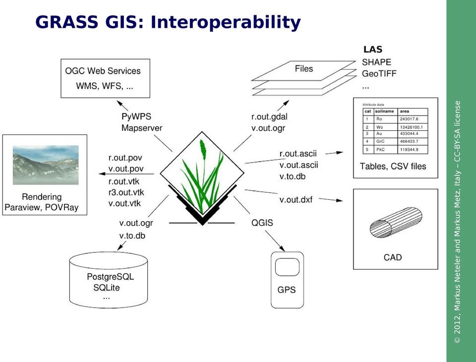

7 Extra bonus: export to Python scripts GRASS: New Geospatial Modeller

8 Raster and 3D vector Trento, Italy Optional: KML export for virtual globes Elevation model combined with extruded 3D buildings; also true 3D vector supported

9 GRASS Topological 2D/3D Vector model Vector geometry types g Se m t en Node Vertex Area Node Boundary u Bo ar nd Boundary Centroid Vertex Centroid y Face s Vertex Node Use of Spatial Index Vertex Vertex Vertex S eg me t n nt e m Vertex Vertex Geometry is true 3D when: x, y, z g Se not in all GIS! Point Centroid Line Boundary Area (boundary + centroid) face (3D area) [kernel (3D centroid)] [volumes (faces + kernel)] Node Line
 face (3D area) [kernel (3D centroid)] [volumes")
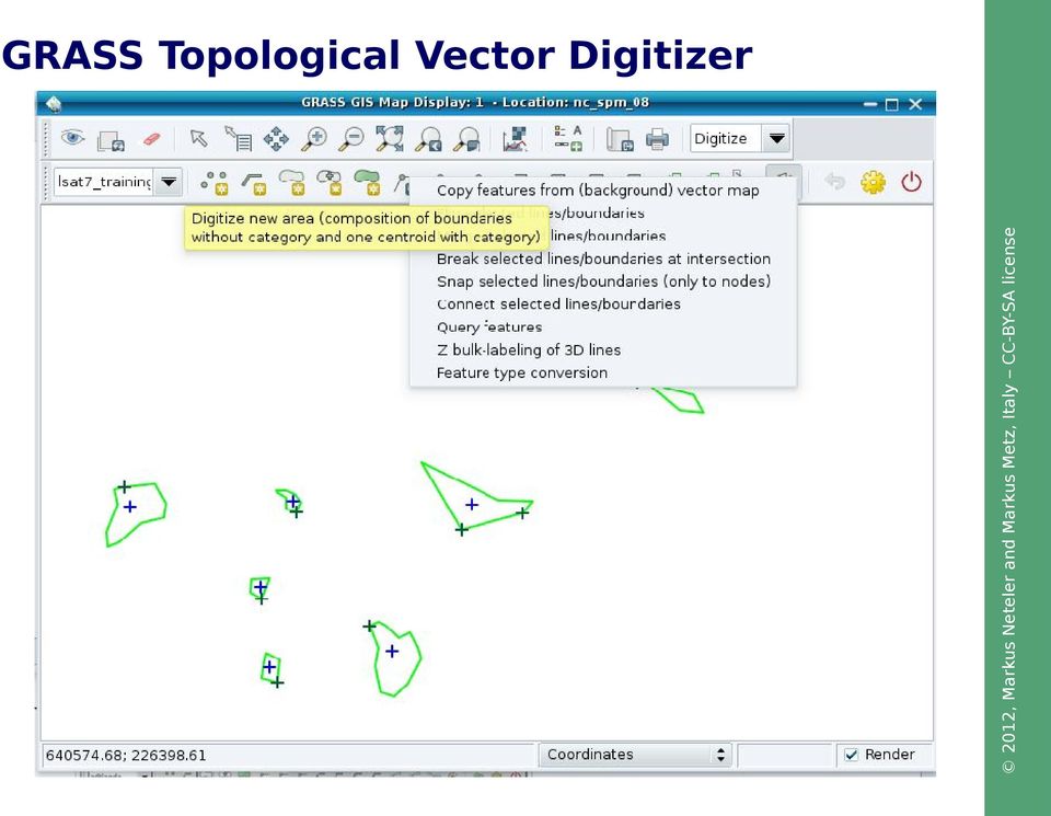
10 GRASS Topological Vector Digitizer

11 GRASS Addons: User contributed extensions The Addons repository is SVN based: User can easily obtain write access to develop new functionality Installation with extension manager Increasing inflow of Python scripts

12 in GRASS GIS Support for massive spatial datasets

13 GRASS 7 raster processing Standard nearest neighbour, linear, cubic, lanczos Spline based Regularized Spline Tension (RST), bspline Statistical average, median, mode, min, max, sum, variance, stddev, quantile Filtering window Bartlett, gauss, hermite, sinc, lanczos1, lanczos2, lanczos3, hann, hamming, blackman and any combination thereof Raster resampling

 Regularized Spline Tension (RST) Bspline")

14 GRASS 7 raster processing Inverse Distance Weighing (IDW) Regularized Spline Tension (RST) Bspline (Tykhonov regularization) Ordinary kriging Filtering window Raster surface interpolation from raster or vector points

15 Processing of LiDAR data: laser scanning of the terrain Lidar First pulse Last pulse Digital Situation Model (DSM) Digital Terrain Model (DTM) Processing 500 Million points... M. Brovelli and R. Antolín H. Mitasova


16 Processing of LiDAR data: laser scanning of the terrain Output as vector points: Output as raster map: v.in.lidar r.in.lidar Lidar First pulse Last pulse Digital Surface Model (DSM) Digital Terrain Model (DTM) New in GRASS 7: direct import of LiDAR LAS files

17 Lidar data analysis in GRASS GIS Available Methods: - cell based statistics - binning - spatial approximation - smoothing Use cases: - topographic analysis - Feature extraction (Separation DEM/DSM) H. Mitasova, NCSU M. Brovelli, PdM, Como Multi-return Lidar data
 H. Mitasova, NCSU M.")
18 Lidar based DTM/DSM with orthophoto draped over it (GRASS: r.sun JRC) and NVIZ) N Lidar data in action: Visualization and solar energy

19 GRASS 7: Support for massive datasets Massive is relative to Hardware resources Software capabilities Operating system capabilities Limiting factors RAM Processing time Disk space Largest supported file size What is massive?

20 GRASS 7: Support for massive datasets Massive is relative to Hardware resources Software capabilities Operating system capabilities Limiting factors RAM Processing time Disk space Largest supported file size What is massive?

21 GRASS 7: Support for massive datasets 600 seconds GRASS GRASS million points Cost surfaces: r.cost
22 Example: Hydrological modelling (think massive data) Distance to the outlet Metz et al. 2011, Hydrology and Earth System Sciences Stream network extraction around the Panama channel (250 million pixel)

23 Main basins Distance to the outlet New tools for hydrological modelling
24 News in Image processing Georectification Orthorectification Atmospheric correction Terrain correction Landsat cloud detection Rocchini, D., Metz, M., Frigeri, A., Delucchi, L., Marcantonio, M., Neteler, M. (2011). Robust rectification of aerial photographs in an Open Source environment. (in press) Improved modules:
25 News in GRASS 7's Vector Topology Spatial query example GUI: click on vector map, what is there? CLI: v.what east_north=east,north 600 seconds GRASS GRASS million points Query of vector point maps
26 News in GRASS 7's Vector Topology Size reduction most prominent for 3D points E.g with ~ points GRASS 6.4: 5.5 MB GRASS 7.0: 0.5 MB Slimmed down topology format
27 News in GRASS 7's Vector Topology Topological cleaning, vector import example Global Administrative Database (GADM), all three levels, global Example:
28 Connecting to other software packages GRASS GIS as Open Source GIS backbone:

29 Doxygen generated programmer's manual
30 GRASS and Python Script part: Parser part (for GUI autocreation and command line support):

31 New GRASS-Python API since 2012

32 source/browse/trunk/modules/java/v_sample_rast.java GRASS and Java
33 Web Processing Service Geostatistics Predictive modeling View Interact Teach raster External data Database engine: Tables, attributes vector GRASS GIS Spatial Analysis Modeling Visualize DBF What you can do with Open Source GIS...
34 GRASS and QGIS Integration: GRASS Toolbox
35 New GRASS and QGIS Integration: Sextante
 future.")
36 Note: Partially functional in gvsig OADE 2010, more to come in (near) future... SEXTANTE GRASS Integration: Modeller
37 Server Client Web Current Server implementations PyWPS: Python 52N WPS: Java vtkgrassbridge: VTK, C, C++, Py, Java ZOO project - various languages... J Cepicky, Controlling an analytical GIS from Web Ch. Schwartze, Geoinformatics FCE CTU 2008 Web Processing Service WPS
38 GRASS 7 WPS Support
39 GRASS and R Integration R version ( )... > library(spgrass6) Loading required package: sp Loading required package: rgdal Geospatial Data Abstraction Library extensions to R successfully loaded Loaded GDAL runtime: GDAL 1.7.3, released 2010/11/10 Path to GDAL shared files: /usr/local/share/gdal Loaded PROJ.4 runtime: Rel , 23 September 2009, [PJ_VERSION: 470] Path to PROJ.4 shared files: (autodetected) Loading required package: XML GRASS GIS interface loaded with GRASS version: 6.4.2svn and location: nc_spm_08 > myrast <- readrast6(c("geology", "elevation"), cat=c(true, FALSE)) > myvect <- readvect6("roads") > writerast6(myrast, "elev_filt", zcol="elev")... GRASS 6.4.2svn (patutm32):~/papers > R
40 Povray rendering ( adding clouds and haze Furthermore: OpenSceneGraph, Ratman,... Visualization: GRASS data export to Paraview and Povray
41 GRASS GIS, Paraview, and ARToolkit Visualization: GRASS data export to for Augmented Reality
42 A researcher's brain... From MRT scan to Voxels Our FEM colleague --> Personal comm.
43 A researcher's brain... From MRT scan to Voxels
44 A researcher's brain... From MRT scan to Voxels
45 A researcher's brain... From MRT scan to Voxels

46 New Space-Time functionality in GRASS 7 Developed by Sören Gebbert --> Enjoy on Friday!
47 public health and eco-epidemiology GRASS GIS applications in
48 West Nile Chikungunya Saint Louis encephalitis Yellow fever Roiz, Neteler et al Tiger mosquito: Disease vector Spreads in Europe and elsewhere Small containers, used tires and lucky bamboo plants are relevant breeding sites >200 cases of Chikungunya in northern Italy in 2007 (CHIKv imported by India traveler and was then spread by Ae. Albopictus) Dengue Spread of the tiger mosquito (Aedes albopictus): infectious disease vector De Llamballerie et al., 2008: Chikungunya
49 Neteler et al., 2011: Int J Health Geogr, 10:49, Roiz, D., Neteler, M., et al., 2011: Climatic factors... tiger mosquito. Plos ONE, 6(4): e14800


50 Parallelised GIS Processing 19 single-blades and 2 double-blades In total 300 nodes with 600 Gb RAM Circa 2 Tflops/s Linux operating system, blades headless with onesis GRASS GIS and R-stats Queue system for job management (Grid Engine) Processing of all 14,000 maps in parallel: one map per node Computational time: 3 weeks with LST-algorithm V1.1 GRASS GIS Infrastructure: FEM-GIS Cluster
51 Roiz D., Neteler M., Castellani C., Arnoldi D., Rizzoli A., 2011: Climatic Factors Driving Invasion of the Tiger Mosquito (Aedes albopictus) into New Areas of Trentino, Northern Italy. PLoS ONE. 6(4): e14800 LST Applications: Tiger mosquito survival today...
52 Pixel-wise time series (meteo versus MODIS LST): European LST mosaic... usable as virtual meteorologic stations for temperature 250m resolution, 4 maps per day, data since 2000 Metz & Neteler, in prep. Neteler, M., 2010: Estimating daily LST... Remote Sensing 2(1), [PDF] The new European daily MODIS LST time series
53 Further MODIS LST Applications Viticulture classification based on MODIS LST derived Winkler Index Zorer et al., Use of multi-annual MODIS land surface temperature data for the characterization of the heat requirements for grapevine varieties. Proc. Multitemp 2011, Trento, Agriculture examples: Wine production: Winkler index in order to classify climate Growing degree day (GDD) maps: plant- and insect phenology
54 Why we are here... Open science wants Open Source!
55 Almost unlimited possibilities with GRASS GIS and other FOSS4G software thanks to the contributing communities Use GRASS GIS yourself on Tuesday! Enjoy! Markus Neteler & Markus Metz Fondazione E. Mach (FEM) Centro Ricerca e Innovazione GIS and Remote Sensing Unit S. Michele all'adige (Trento), Italy Conclusions
56 Open Source Geospatial Foundation A gentle introduction to OSGeo:
57 GRASS GIS FDO metacrs the OSGeo community: more than 19,000 unique subscribers in 150 topic oriented mailing lists Open Source GIS brought to you by...
58 Open Source Geospatial Foundation OSGeo supports: Software Data Education Community

59 OSGeo Geodata Committee & Data
60 OSGeo Education: Courses Gallery enable people to teach 2012: >60 Tutorials and courses
61 FOSS4G bookshelf: read more!
From a niche to a global user community: Open Source GIS and OSGeo
 From a niche to a global user community: Open Source GIS and OSGeo Opensource Geospatial Research Symposium Nantes, 8-10 July 2009 http://www.ogrs2009.org Markus Neteler Fondazione E Mach - CRI Italy,
GRASS GIS in the Cloud
 GRASS GIS in the Cloud Fondazione Edmund Mach GIS & Remote Sensing Platform http://gis.cri.fmach.it XIII Meeting GRASS e GFOSS 17th February 2012, Trieste (Italy) Cloud Our cluster Cloud Cloud computing
3D Model of the City Using LiDAR and Visualization of Flood in Three-Dimension
 3D Model of the City Using LiDAR and Visualization of Flood in Three-Dimension R.Queen Suraajini, Department of Civil Engineering, College of Engineering Guindy, Anna University, India, suraa12@gmail.com
GRASS GIS processing to detect thermal anomalies with TABI sensor
 GRASS GIS processing to detect thermal anomalies with TABI sensor Carmine Massarelli, Raffaella Matarrese, Vito Felice Uricchio, Michele Vurro Water Research Institute - Italian National Research Council
An Introduction to Open Source Geospatial Tools
 An Introduction to Open Source Geospatial Tools by Tyler Mitchell, author of Web Mapping Illustrated GRSS would like to thank Mr. Mitchell for this tutorial. Geospatial technologies come in many forms,
Managing Lidar (and other point cloud) Data. Lindsay Weitz Cody Benkelman
 Data. Lindsay Weitz Cody Benkelman") (and other point cloud) Data Lindsay Weitz Cody Benkelman Presentation Context What is lidar, and how does it work? Not this presentation! What can you do with lidar in ArcGIS? What does Esri recommend
(and other point cloud) Data Lindsay Weitz Cody Benkelman Presentation Context What is lidar, and how does it work? Not this presentation! What can you do with lidar in ArcGIS? What does Esri recommend
Files Used in this Tutorial
 Generate Point Clouds Tutorial This tutorial shows how to generate point clouds from IKONOS satellite stereo imagery. You will view the point clouds in the ENVI LiDAR Viewer. The estimated time to complete
Institute of Natural Resources Departament of General Geology and Land use planning Work with a MAPS
 Institute of Natural Resources Departament of General Geology and Land use planning Work with a MAPS Lecturers: Berchuk V.Y. Gutareva N.Y. Contents: 1. Qgis; 2. General information; 3. Qgis desktop; 4.
3D Building Roof Extraction From LiDAR Data
 3D Building Roof Extraction From LiDAR Data Amit A. Kokje Susan Jones NSG- NZ Outline LiDAR: Basics LiDAR Feature Extraction (Features and Limitations) LiDAR Roof extraction (Workflow, parameters, results)
MrSID Plug-in for 3D Analyst
 LizardTech MrSID Plug-in for 3D Analyst User Manual Copyrights Copyright 2009 2010 LizardTech. All rights reserved. Information in this document is subject to change without notice. The software described
LiDAR Point Cloud Processing with
 LiDAR Research Group, Uni Innsbruck LiDAR Point Cloud Processing with SAGA Volker Wichmann Wichmann, V.; Conrad, O.; Jochem, A.: GIS. In: Hamburger Beiträge zur Physischen Geographie und Landschaftsökologie
GeoKettle: A powerful open source spatial ETL tool
 GeoKettle: A powerful open source spatial ETL tool FOSS4G 2010 Dr. Thierry Badard, CTO Spatialytics inc. Quebec, Canada tbadard@spatialytics.com Barcelona, Spain Sept 9th, 2010 What is GeoKettle? It is
GIS. Digital Humanities Boot Camp Series
 GIS Digital Humanities Boot Camp Series GIS Fundamentals GIS Fundamentals Definition of GIS A geographic information system (GIS) is used to describe and characterize spatial data for the purpose of visualizing
ANALYSIS 3 - RASTER What kinds of analysis can we do with GIS?
 ANALYSIS 3 - RASTER What kinds of analysis can we do with GIS? 1. Measurements 2. Layer statistics 3. Queries 4. Buffering (vector); Proximity (raster) 5. Filtering (raster) 6. Map overlay (layer on layer
Cloud-based Geospatial Data services and analysis
 Cloud-based Geospatial Data services and analysis Xuezhi Wang Scientific Data Center Computer Network Information Center Chinese Academy of Sciences 2014-08-25 Outlines 1 Introduction of Geospatial Data
Comparison of Open Source Virtual Globes
 FOSS4G 2010 Comparison of Open Source Virtual Globes Mathias Walker Pirmin Kalberer Sourcepole AG, Bad Ragaz www.sourcepole.ch About Sourcepole GIS-Knoppix: first GIS live-cd QGIS Core developer QGIS Mapserver
Introduction to GIS (Basics, Data, Analysis) & Case Studies. 13 th May 2004. Content. What is GIS?
 & Case Studies. 13 th May 2004. Content. What is GIS?") Introduction to GIS (Basics, Data, Analysis) & Case Studies 13 th May 2004 Content Introduction to GIS Data concepts Data input Analysis Applications selected examples What is GIS? Geographic Information
Introduction to GIS (Basics, Data, Analysis) & Case Studies 13 th May 2004 Content Introduction to GIS Data concepts Data input Analysis Applications selected examples What is GIS? Geographic Information
First Steps. Setup, data import, visualization and basic terrain analysis. Volker Wichmann
 SAGA First Steps Setup, data import, visualization and basic terrain analysis Volker Wichmann SAGA Setup on Windows Download of SAGA 2.0.8 binaries (1) www.saga-gis.org (2) >> Downloads (@ SourceForge)
Documentation of open source GIS/RS software projects
 Contract. Workpackage Delivery Delivery Date 030776 WP1 D1.6 2008-04-24 CASCADOSS Development of a trans-national cacade training programme on Open Source GIS&RS Software for environmental applications
Impact of water harvesting dam on the Wadi s morphology using digital elevation model Study case: Wadi Al-kanger, Sudan
 Impact of water harvesting dam on the Wadi s morphology using digital elevation model Study case: Wadi Al-kanger, Sudan H. S. M. Hilmi 1, M.Y. Mohamed 2, E. S. Ganawa 3 1 Faculty of agriculture, Alzaiem
SUMMER SCHOOL ON ADVANCES IN GIS
 SUMMER SCHOOL ON ADVANCES IN GIS Six Workshops Overview The workshop sequence at the UMD Center for Geospatial Information Science is designed to provide a comprehensive overview of current state-of-the-art
Big Data and Analytics: Getting Started with ArcGIS. Mike Park Erik Hoel
 Big Data and Analytics: Getting Started with ArcGIS Mike Park Erik Hoel Agenda Overview of big data Distributed computation User experience Data management Big data What is it? Big Data is a loosely defined
Project Title: Project PI(s) (who is doing the work; contact Project Coordinator (contact information): information):
 (who is doing the work; contact Project Coordinator (contact information): information):") Project Title: Great Northern Landscape Conservation Cooperative Geospatial Data Portal Extension: Implementing a GNLCC Spatial Toolkit and Phenology Server Project PI(s) (who is doing the work; contact
Project Title: Great Northern Landscape Conservation Cooperative Geospatial Data Portal Extension: Implementing a GNLCC Spatial Toolkit and Phenology Server Project PI(s) (who is doing the work; contact
VisIt Visualization Tool
 The Center for Astrophysical Thermonuclear Flashes VisIt Visualization Tool Randy Hudson hudson@mcs.anl.gov Argonne National Laboratory Flash Center, University of Chicago An Advanced Simulation and Computing
The following was presented at DMT 14 (June 1-4, 2014, Newark, DE).
.") DMT 2014 The following was presented at DMT 14 (June 1-4, 2014, Newark, DE). The contents are provisional and will be superseded by a paper in the DMT 14 Proceedings. See also presentations and Proceedings
DMT 2014 The following was presented at DMT 14 (June 1-4, 2014, Newark, DE). The contents are provisional and will be superseded by a paper in the DMT 14 Proceedings. See also presentations and Proceedings
Web and Mobile GIS Applications Development
 Web and Mobile GIS Applications Development Presented by : Aamir Ali Manager Section Head (GIS Software Customization) Pakistan Space and Upper Atmosphere Research Commission (SUPARCO) Geographical Information
How To Write An Nccwsc/Csc Data Management Plan
 Guidance and Requirements for NCCWSC/CSC Plans (Required for NCCWSC and CSC Proposals and Funded Projects) Prepared by the CSC/NCCWSC Working Group Emily Fort, Data and IT Manager for the National Climate
Blender addons ESRI Shapefile import/export and georeferenced raster import
 Blender addons ESRI Shapefile import/export and georeferenced raster import This blender addon is a collection of 4 tools: ESRI Shapefile importer - Import point, pointz, polyline, polylinez, polygon,
WebFOCUS RStat. RStat. Predict the Future and Make Effective Decisions Today. WebFOCUS RStat
 Information Builders enables agile information solutions with business intelligence (BI) and integration technologies. WebFOCUS the most widely utilized business intelligence platform connects to any enterprise
GIS Initiative: Developing an atmospheric data model for GIS. Olga Wilhelmi (ESIG), Jennifer Boehnert (RAP/ESIG) and Terri Betancourt (RAP)
, Jennifer Boehnert (RAP/ESIG) and Terri Betancourt (RAP)") GIS Initiative: Developing an atmospheric data model for GIS Olga Wilhelmi (ESIG), Jennifer Boehnert (RAP/ESIG) and Terri Betancourt (RAP) Unidata seminar August 30, 2004 Presentation Outline Overview
GIS Initiative: Developing an atmospheric data model for GIS Olga Wilhelmi (ESIG), Jennifer Boehnert (RAP/ESIG) and Terri Betancourt (RAP) Unidata seminar August 30, 2004 Presentation Outline Overview
Chapter Contents Page No
 Chapter Contents Page No Preface Acknowledgement 1 Basics of Remote Sensing 1 1.1. Introduction 1 1.2. Definition of Remote Sensing 1 1.3. Principles of Remote Sensing 1 1.4. Various Stages in Remote Sensing
Advanced Image Management using the Mosaic Dataset
 Esri International User Conference San Diego, California Technical Workshops July 25, 2012 Advanced Image Management using the Mosaic Dataset Vinay Viswambharan, Mike Muller Agenda ArcGIS Image Management
CHAPTER FIVE RESULT ANALYSIS
 CHAPTER FIVE RESULT ANALYSIS 5.1 Chapter Introduction 5.2 Discussion of Results 5.3 Performance Comparisons 5.4 Chapter Summary 61 5.1 Chapter Introduction This chapter outlines the results obtained from
INTEROPERABLE IMAGE DATA ACCESS THROUGH ARCGIS SERVER
 INTEROPERABLE IMAGE DATA ACCESS THROUGH ARCGIS SERVER Qian Liu Environmental Systems Research Institute 380 New York Street Redlands, CA92373, U.S.A - qliu@esri.com KEY WORDS: OGC, Standard, Interoperability,
Laboratory for development of open source geospatial technologies role in education and research
 UDC: 007:528.93]:004.6 DOI:10.1448/gn.2014.10 Typology: 1.04 Professional Article Laboratory for development of open source geospatial technologies role in education and research Milan Kilibarda 1*, Branislav
Review for Introduction to Remote Sensing: Science Concepts and Technology
 Review for Introduction to Remote Sensing: Science Concepts and Technology Ann Johnson Associate Director ann@baremt.com Funded by National Science Foundation Advanced Technological Education program [DUE
REPORT FOR DELIVERABLE D4.2
 REPORT FOR DELIVERABLE D4.2 1 1 INTRODUCTION This report provides an overview of the technical characteristics and functionality of deliverable D4.2 Web Processing Services. Its purpose is to provide a
3D Point Cloud Analytics for Updating 3D City Models
 3D Point Cloud Analytics for Updating 3D City Models Rico Richter 25 th May 2015 INSPIRE - Geospatial World Forum 2015 Background Hasso Plattner Institute (HPI): Computer Graphics Systems group of Prof.
Environmental Remote Sensing GEOG 2021
 Environmental Remote Sensing GEOG 2021 Lecture 4 Image classification 2 Purpose categorising data data abstraction / simplification data interpretation mapping for land cover mapping use land cover class
ERDAS IMAGINE The world s most widely-used remote sensing software package
 ERDAS IMAGINE The world s most widely-used remote sensing software package ERDAS IMAGINE Geographic imaging professionals need to process vast amounts of geospatial data every day often relying on software
High-Performance Visualization of Geographic Data
 High-Performance Visualization of Geographic Data Presented by Budhendra Bhaduri Alexandre Sorokine Geographic Information Science and Technology Computational Sciences and Engineering Managed by UT-Battelle
Introduction to Geographic Information System course SESREMO Tempus Project. Gabriel Parodi
 WRS - ITC. The Netherlands. Introduction to Geographic Information System course SESREMO Tempus Project. Gabriel Parodi Curricula transfer 2014 INTRODUCTION TO GIS COURSE- SESREMO TEMPUS Table of Contents
SHOALS Toolbox: Software to Support Visualization and Analysis of Large, High-Density Data Sets
 SHOALS Toolbox: Software to Support Visualization and Analysis of Large, High-Density Data Sets by Jennifer M. Wozencraft, W. Jeff Lillycrop, and Nicholas C. Kraus PURPOSE: The Coastal and Hydraulics Engineering
<Insert Picture Here> Data Management Innovations for Massive Point Cloud, DEM, and 3D Vector Databases
 Data Management Innovations for Massive Point Cloud, DEM, and 3D Vector Databases Xavier Lopez, Director, Product Management 3D Data Management Technology Drivers: Challenges & Benefits
Server GIS. What Server GIS software do we provide?
 Server GIS Distribute maps, models, and tools via the Web in a way that fits well into your workflows. SuperGeo offers numerous Server GIS solutions to fulfill the demands of corporate Intranets and the
Managing Imagery and Raster Data in ArcGIS
 Technical Workshops Managing Imagery and Raster Data in ArcGIS Hong Xu, Sangeet Mathew, Mark Harris Presentation Overview ArcGIS raster data models Which model to use Mosaic dataset storage and properties
Tutorial for using Titan2D, online simulation tool on Vhub. Sylvain Charbonnier
 Tutorial for using Titan2D, online simulation tool on Vhub Sylvain Charbonnier Introduction The Titan2D toolkit is used for modeling of geophysical mass flows over natural terrain (volcanic flows, avalanches,
Remote Sensing, GPS and GIS Technique to Produce a Bathymetric Map
 Remote Sensing, GPS and GIS Technique to Produce a Bathymetric Map Mark Schnur EES 5053 Remote Sensing Fall 2007 University of Texas at San Antonio, Department of Earth and Environmental Science, San Antonio,
A quick overview of geographic information systems (GIS) Uwe Deichmann, DECRG <udeichmann@worldbank.org>
 Uwe Deichmann, DECRG <udeichmann@worldbank.org>") A quick overview of geographic information systems (GIS) Uwe Deichmann, DECRG Why is GIS important? A very large share of all types of information has a spatial component ( 80
A quick overview of geographic information systems (GIS) Uwe Deichmann, DECRG Why is GIS important? A very large share of all types of information has a spatial component ( 80
Big Data Volume & velocity data management with ERDAS APOLLO. Alain Kabamba Hexagon Geospatial
 Big Data Volume & velocity data management with ERDAS APOLLO Alain Kabamba Hexagon Geospatial Intergraph is Part of the Hexagon Family Hexagon is dedicated to delivering actionable information through
Documentation of open source GIS/RS software projects
 Contract no. Workpackage Delivery Delivery Date 030776 WP1 D1.6 2007-07-02 CASCADOSS Development of a trans-national cascade training programme on Open Source GIS&RS Software for environmental applications
Handling Heterogeneous EO Datasets via the Web Coverage Processing Service
 Handling Heterogeneous EO Datasets via the Web Coverage Processing Service Piero Campalani a*, Simone Mantovani b, Alan Beccati a, a a a Jacobs University Bremen (DE) / b MEEO Srl (IT) * {p.campalani@jacobs-university.de
PART 1. Representations of atmospheric phenomena
 PART 1 Representations of atmospheric phenomena Atmospheric data meet all of the criteria for big data : they are large (high volume), generated or captured frequently (high velocity), and represent a
CityGML goes to Broadway
 CityGML goes to Broadway Thomas H. Kolbe, Barbara Burger, Berit Cantzler Chair of Geoinformatics thomas.kolbe@tum.de September 11, 2015 Photogrammetric Week 2015, Stuttgart The New York City Open Data
REGIONAL CENTRE FOR TRAINING IN AEROSPACE SURVEYS (RECTAS) MASTER IN GEOINFORMATION PRODUCTION AND MANAGEMENT
 MASTER IN GEOINFORMATION PRODUCTION AND MANAGEMENT") REGIONAL CENTRE FOR TRAINING IN AEROSPACE SURVEYS (RECTAS) MASTER IN GEOINFORMATION PRODUCTION AND MANAGEMENT PROGRAMME DESCRIPTION October 2014 1. The programme The academic programme shall be referred
REGIONAL CENTRE FOR TRAINING IN AEROSPACE SURVEYS (RECTAS) MASTER IN GEOINFORMATION PRODUCTION AND MANAGEMENT PROGRAMME DESCRIPTION October 2014 1. The programme The academic programme shall be referred
Getting Started With LP360
 Getting Started With LP360 10/30/2014 1 Contents What is LP360?... 3 System Requirements... 3 Installing LP360... 4 How to Enable the LP360 Extension... 4 How to Display the LP360 Toolbar... 4 How to Import
Notable near-global DEMs include
 Visualisation Developing a very high resolution DEM of South Africa by Adriaan van Niekerk, Stellenbosch University DEMs are used in many applications, including hydrology [1, 2], terrain analysis [3],
NetCDF and HDF Data in ArcGIS
 2013 Esri International User Conference July 8 12, 2013 San Diego, California Technical Workshop NetCDF and HDF Data in ArcGIS Nawajish Noman Kevin Butler Esri UC2013. Technical Workshop. Outline NetCDF
Integrated Information Management System, Development of Web Interface, a.k.a. Online Data Portal (ODP)
") Integrated Information Management System, Development of Web Interface, a.k.a. Online Data Portal (ODP) USBR Science and Technology Project ID 3625 Eric Peterson, May 2014. Duration: Fiscal Year 2010 through
Integrated Information Management System, Development of Web Interface, a.k.a. Online Data Portal (ODP) USBR Science and Technology Project ID 3625 Eric Peterson, May 2014. Duration: Fiscal Year 2010 through
Open Source GIS The Future?
 Open Source GIS The Future? Daniel Morissette DM Solutions Group Inc. Open Source Licensing No licensing costs Unlimited rights to: Use the software View and analyse the source Copy, reuse in other systems
Introduction to Imagery and Raster Data in ArcGIS
 Esri International User Conference San Diego, California Technical Workshops July 25, 2012 Introduction to Imagery and Raster Data in ArcGIS Simon Woo slides Cody Benkelman - demos Overview of Presentation
Using PCI Geomatics Software with Oracle 10g Spatial and GeoRaster A PCI Geomatics Whitepaper
 Using PCI Geomatics Software with Oracle 10g Spatial and GeoRaster A PCI Geomatics Whitepaper November 2005 Table of Contents Table of Contents...1 1. Introduction...2 2. How Geomatica adds value to Oracle
TUTORIAL MOVE 2009.1: 3D MODEL CONSTRUCTION FROM SURFACE GEOLOGICAL DATA
 UNIVERSITÁ DEGLI STUDI DI MILANO FACOLTÀ DI SCIENZE MATEMATICHE FISICHE E NATURALI DIPARTIMENTO DI SCIENZE DELLA TERRA ARDITO DESIO TUTORIAL MOVE 2009.1: 3D MODEL CONSTRUCTION FROM SURFACE GEOLOGICAL DATA
Web Mapping in Archaeology
 Non-invasive methods in the contemporary archaeological practice 25th February 2014 http://www.pborycki.pl/pdf/webmapping.pdf Plan of the presentation 1 Web Mapping General Idea History of Web Mapping
The Use of Geographic Information Systems in Risk Assessment
 The Use of Geographic Information Systems in Risk Assessment With Specific Focus on the RiVAMP Methodology Presented by Nadine Brown August 27, 2012 Climate Studies Group Mona Climate Change Workshop Presentation
New Features in TerraScan. Arttu Soininen Software developer Terrasolid Ltd
 New Features in TerraScan Arttu Soininen Software developer Terrasolid Ltd Version 013.xxx Computer ID changes in licenses Send new computer ID to Terrasolid if using: Server pool licenses (server ID and
Integration of location based services for Field support in CRM systems
 Invited Contribution to GeoInformatics. Deadline September 15, 2001. Integration of location based services for Field support in CRM systems By P. Álvarez, J.A. Bañares, P.R. Muro-Medrano and F.J. Zarazaga
Mr. Apichon Witayangkurn apichon@iis.u-tokyo.ac.jp Department of Civil Engineering The University of Tokyo
 Sensor Network Messaging Service Hive/Hadoop Mr. Apichon Witayangkurn apichon@iis.u-tokyo.ac.jp Department of Civil Engineering The University of Tokyo Contents 1 Introduction 2 What & Why Sensor Network
The needs on big data management for Operational Geo-Info Services: Emergency Response, Maritime surveillance, Agriculture Management
 Copernicus Big-Data Workshop 2014, 13/14 March The needs on big data management for Operational Geo-Info Services: Emergency Response, Maritime surveillance, Agriculture Management Marco Corsi e-geos 1
Objectives. Raster Data Discrete Classes. Spatial Information in Natural Resources FANR 3800. Review the raster data model
 Spatial Information in Natural Resources FANR 3800 Raster Analysis Objectives Review the raster data model Understand how raster analysis fundamentally differs from vector analysis Become familiar with
Technology Trends In Geoinformation
 Technology Trends In Geoinformation Dato Prof. Sr Dr. Abdul Kadir Bin Taib Department of Survey and Mapping Malaysia (JUPEM) Email: drkadir@jupem.gov.my www.jupem.gov.my NGIS 2008 3 rd. National GIS Conference
Cloud-based Linked Data Geoprocessing: Implementing Kriging as WPS on the Cloud
 Cloud-based Linked Data Geoprocessing: Implementing Kriging as WPS on the Cloud Elias Grinias Department of Civil Engineering, Surveying and Geomatics, TEI of Central Macedonia and Dimitris Kotzinos ETIS
CLOUD BASED N-DIMENSIONAL WEATHER FORECAST VISUALIZATION TOOL WITH IMAGE ANALYSIS CAPABILITIES
 CLOUD BASED N-DIMENSIONAL WEATHER FORECAST VISUALIZATION TOOL WITH IMAGE ANALYSIS CAPABILITIES M. Laka-Iñurrategi a, I. Alberdi a, K. Alonso b, M. Quartulli a a Vicomteh-IK4, Mikeletegi pasealekua 57,
Facts about Visualization Pipelines, applicable to VisIt and ParaView
 Facts about Visualization Pipelines, applicable to VisIt and ParaView March 2013 Jean M. Favre, CSCS Agenda Visualization pipelines Motivation by examples VTK Data Streaming Visualization Pipelines: Introduction
Intergraph Geospatial Portfolio 2013
 W H A T S N E W? Intergraph Geospatial Portfolio 2013 Photogrammetry LPS ImageStation Remote Sensing ERDAS IMAGINE GIS GeoMedia Server GeoMedia WebMap GeoMedia Smart Client ERDAS APOLLO Geospatial SDI
Point Clouds: Big Data, Simple Solutions. Mike Lane
 Point Clouds: Big Data, Simple Solutions Mike Lane Light Detection and Ranging Point Cloud is the Third Type of Data Vector Point Measurements and Contours Sparse, highly irregularly spaced X,Y,Z values
CLIDATA In Ostrava 18/06/2013
 CLIDATA In Ostrava 18/06/2013 Content Introduction...3 Structure of Clidata Application...4 Clidata Database...5 Rich Java Client...6 Oracle Discoverer...7 Web Client...8 Map Viewer...9 Clidata GIS and
Institute of Computational Modeling SB RAS
 Institute of Computational Modeling SB RAS ORGANIZATION OF ACCESS TO OBSERVATIONAL DATA USING WEB SERVICES FOR MONITORING SYSTEMS THE STATE OF THE ENVIRONMENT Kadochnikov Aleksey A. Russia, Krasnoyarsk
KEY WORDS: Geoinformatics, Geoinformation technique, Remote Sensing, Information technique, Curriculum, Surveyor.
 CURRICULUM OF GEOINFORMATICS INTEGRATION OF REMOTE SENSING AND GEOGRAPHICAL INFORMATION TECHNOLOGY Kirsi VIRRANTAUS*, Henrik HAGGRÉN** Helsinki University of Technology, Finland Department of Surveying
ENVI THE PREMIER SOFTWARE FOR EXTRACTING INFORMATION FROM GEOSPATIAL IMAGERY.
 ENVI THE PREMIER SOFTWARE FOR EXTRACTING INFORMATION FROM GEOSPATIAL IMAGERY. ENVI Imagery Becomes Knowledge ENVI software uses proven scientific methods and automated processes to help you turn geospatial
GIS Data in ArcGIS. Pay Attention to Data!!!
 GIS Data in ArcGIS Pay Attention to Data!!! 1 GIS Data Models Vector Points, lines, polygons, multi-part, multi-patch Composite & secondary features Regions, dynamic segmentation (routes) Raster Grids,
Standardized data sharing through an open-source Spatial Data Infrastructure: the Afromaison project
 Standardized data sharing through an open-source Spatial Data Infrastructure: the Afromaison project Yaniss Guigoz - University of Geneva/GRID-Geneva 1 EcoARM2ERA and AFROMAISON Why Afromaison in this
The Courses. Covering complete breadth of GIS technology from ESRI including ArcGIS, ArcGIS Server and ArcGIS Engine.
 ESRI India: Corporate profile ESRI India A profile India s Premier GIS Company Strategic alliance between ESRI Inc. and NIIT Technologies Adjudged as India s Best GIS Solutions Company - Map India 2001
A GIS helps you answer questions and solve problems by looking at your data in a way that is quickly understood and easily shared.
 A Geographic Information System (GIS) integrates hardware, software, and data for capturing, managing, analyzing, and displaying all forms of geographically referenced information. GIS allows us to view,
D3.4.1: Data Fusion Tools
 COMPETITIVINESS AND INNOVATION FRAMEWORK PROGRAMME CIP-ICT-PSP-2013-7 Pilot Type B WP3 Service platform integration and deployment in cloud infrastructure D3.4.1: Data Fusion Tools Deliverable Lead: NETCAD
The paths of Via Regina geomatics for sustainable mobility
 FOSS4G Europe Bremen 15-17 July 2014 The paths of Via Regina geomatics for sustainable mobility Maria Antonia Brovelli (*), Massimiliano Cannata (**), Alba Lucchese (*), Marco Minghini (*), Marco Negretti
Analysis of Climatic and Environmental Changes Using CLEARS Web-GIS Information-Computational System: Siberia Case Study
 Analysis of Climatic and Environmental Changes Using CLEARS Web-GIS Information-Computational System: Siberia Case Study A G Titov 1,2, E P Gordov 1,2, I G Okladnikov 1,2, T M Shulgina 1 1 Institute of
LSA SAF products: files and formats
 LSA SAF products: files and formats Carla Barroso, IPMA Application of Remote Sensing Data for Drought Monitoring Introduction to Eumetsat LANDSAF Products 11-15 November Slovenia OUTLINE Where to get
5. GIS, Cartography and Visualization of Glacier Terrain
 5. GIS, Cartography and Visualization of Glacier Terrain 5.1. Garhwal Himalayan Glaciers 5.1.1. Introduction GIS is the computer system for capturing, storing, analyzing and visualization of spatial and
How is EnSight Uniquely Suited to FLOW-3D Data?
 How is EnSight Uniquely Suited to FLOW-3D Data? July 5, 2011 figure 1. FLOW-3D model of Dam visualized with EnSight If you would like to know how CEI s EnSight offers you more power than other postprocessors
Data source, type, and file naming convention
 Exercise 1: Basic visualization of LiDAR Digital Elevation Models using ArcGIS Introduction This exercise covers activities associated with basic visualization of LiDAR Digital Elevation Models using ArcGIS.
Open Source GIS Blitz!
 Open Source GIS Blitz! Startwiththisvideo http://vimeo.com/2598878 Openstreetmap.org Crown copyright no expiration all government map data in England. Rest of Europe not much better Volunteer mapping effort.
Application of Google Earth for flood disaster monitoring in 3D-GIS
 Disaster Management and Human Health Risk II 271 Application of Google Earth for flood disaster monitoring in 3D-GIS M. Mori & Y. L. Chan Department of Information and Computer Science, Kinki University,
High Resolution RF Analysis: The Benefits of Lidar Terrain & Clutter Datasets
 0 High Resolution RF Analysis: The Benefits of Lidar Terrain & Clutter Datasets January 15, 2014 Martin Rais 1 High Resolution Terrain & Clutter Datasets: Why Lidar? There are myriad methods, techniques
Enterprise Architectures for Large Tiled Basemap Projects. Tommy Fauvell
 Enterprise Architectures for Large Tiled Basemap Projects Tommy Fauvell Tommy Fauvell Senior Technical Analyst Esri Professional Services Washington D.C Regional Office Project Technical Lead: - Responsible
TerraAmazon - The Amazon Deforestation Monitoring System - Karine Reis Ferreira
 TerraAmazon - The Amazon Deforestation Monitoring System - Karine Reis Ferreira GEOSS Users & Architecture Workshop XXIV: Water Security & Governance - Accra Ghana / October 2008 INPE National Institute
DEVELOPMENT OF WEB-BASED GIS INTERFACES FOR APPLICATION OF THE WEPP MODEL
 DEVELOPMENT OF WEB-BASED GIS INTERFACES FOR APPLICATION OF THE WEPP MODEL D.C. Flanagan A, J.R. Frankenberger A, C.S. Renschler B and B.A. Engel C A National Soil Erosion Research Laboratory, USDA-ARS,
Activity: Using ArcGIS Explorer
 Activity: Using ArcGIS Explorer Requirements You must have ArcGIS Explorer for this activity. Preparation: Download ArcGIS Explorer. The link below will bring you to the ESRI ArcGIS Explorer download page.
Lecture 8. Online GIS
 Lecture 8 Online GIS Lecture 8: Outline I. Online GIS 1. Google Earth 2. MSN Live Maps II. Open Source GIS III. ArcGIS Server and the ESRI suite of online software utility options IV. Advanced Data Mining
A Method Using ArcMap to Create a Hydrologically conditioned Digital Elevation Model
 A Method Using ArcMap to Create a Hydrologically conditioned Digital Elevation Model High resolution topography derived from LiDAR data is becoming more readily available. This new data source of topography