BASIN MANAGEMENT OBJECTIVES ANGEL SLOUGH SUBINVENTORY UNIT. Butte County Water Advisory Committee Member Catherine Cottle
|
|
|
- Bertina Gibson
- 8 years ago
- Views:
Transcription
 covers an area of about 5400 acres in the southwest portion of the West Butte Inventory Unit.")
1 BASIN MANAGEMENT OBJECTIVES ANGEL SLOUGH SUBINVENTORY UNIT Butte County Water Advisory Committee Member Catherine Cottle Contact Information Phone Number: Address: Description of the Angel Slough Sub-Inventory Unit The Angel Slough Sub-inventory Unit (SIU) covers an area of about 5400 acres in the southwest portion of the West Butte Inventory Unit. In summer, in a normal year, at least 70% of this area is supported by groundwater. To the northern and easterly directions it is bordered by the M&T sub-inventory Unit. The Llano Seco sub-inventory Unit borders it to the south and to the west it is bordered by the Sacramento River. In times of flooding, water flows directly from the river into Angel Slough. Known to many as "the dips on River Road, it is actually where Angel Slough crosses River Road. This results in flooding of orchard and row crops normally supported by surface water and groundwater and makes River Road impassable by vehicles. At these times, releases by Keswick Dam into the Sacramento River directly effect how long orchard and row crops remain flooded. Monitoring stations at Hamilton City (HMC) and Ord Bend (ORD) track river level data. This information can be found on the California Data Exchange Center (CDEC) website Angel Slough 2014 BMO 1

2 Management Objective It is the intent of this objective to maintain the groundwater surface elevation during the peak summer irrigation season (July and August) in all aquifer systems at a level that will assure an adequate and affordable irrigation groundwater supply, and to assure a sustainable agricultural supply of good quality water now and into the future. The management objective is also to assure a sustainable groundwater supply of good quality from the alluvial aquifer system for all domestic users in the sub-inventory unit and to assure the water supply can be utilized without injuring groundwater quality or inducing land subsidence. Geologic Formations Identified In Sub-Inventory Unit: Geologic formations in the Angel Slough SIU, from youngest (shallowest) to oldest (deepest), include: Quaternary Alluvium Modesto Formation Tehama Formation Tuscan Unit C (Upper Tuscan) Tuscan Unit B (Lower Tuscan) Fresh Water-bearing Units. In the Sacramento Valley Region of Butte County, fresh groundwater-bearing units include, from youngest (shallowest) to oldest (deepest), the Modesto, Riverbank, Laguna, Tehama and Tuscan Formations. Those included in the Angel Slough SIU are: Modesto Formation Tehama Formation Tuscan Unit C (Upper Tuscan) Tuscan Unit B (Lower Tuscan) BMO Key Wells Selected for Groundwater Level Monitoring SPRING Well ID First Aquifer Stage 1 Alerts Well Type Record System 21N01W23J Alluvium Irrigation N01W35K Alluvium Irrigation FALL Well ID Stage 2 Alerts First Aquifer Stage 1 Alerts Well Type Record System 21N01W23J Alluvium Irrigation N01W35K Alluvium Irrigation **2013 Note: Some alert stage elevations have changed slightly due to a change in the vertical datum in the state s database, CASGEM. Numbers are now consistent with CASGEM. Stage 2 Alerts Angel Slough 2014 BMO 2

3 Groundwater Quality There are currently no wells being sampled for water quality within the Angel Slough SIU. Staff and stakeholders are hopeful that an appropriate water quality monitoring well will be located in the future. Land Subsidence Land subsidence will be monitored at the closest extensometers located in the M&T and Western Canal sub-inventory units. Angel Slough SIU Stakeholder Issues and Recommendations Future Monitoring Recommendations Efforts will be made to identify additional domestic wells that could be added to the existing monitoring well network in the sub-inventory unit to allow for development of additional management objectives for the alluvial aquifer system. Locate additional wells, either irrigation or domestic, with sufficient historical construction information to include in the water quality monitoring network. Supporting Data Hydrographs on the following pages depict yearly spring and fall groundwater level measurements with established alert levels. QM Questionable Measurement Angel Slough 2014 BMO 3

4 21N01W23J001M Angel Slough 2014 BMO 4

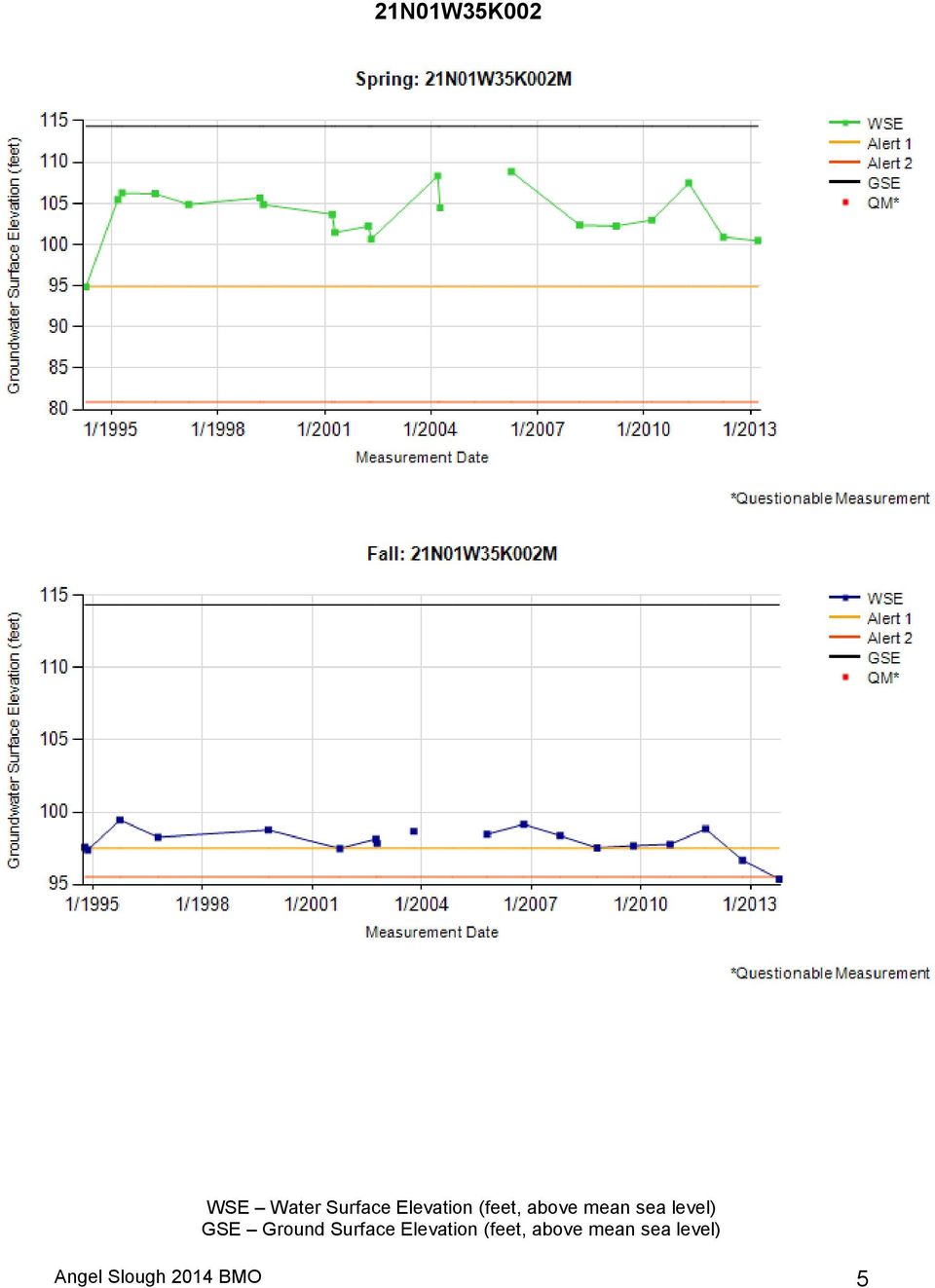
5 21N01W35K002 Angel Slough 2014 BMO 5
BASIN MANAGEMENT OBJECTIVES CHEROKEE SUBINVENTORY UNIT
 BASIN MANAGEMENT OBJECTIVES CHEROKEE SUBINVENTORY UNIT Butte County Water Advisory Committee Member John Scott Contact Information Phone Number: (530) 533-8394 Email Address: john_lewis_scott@msn.com Description
GROUNDWATER CONDITIONS
 GROUNDWATER CONDITIONS IN THE NORTHERN SACRAMENTO VALLEY LOCAL MANAGEMENT OF WATER RESOURCES IN THE NORTHERN SACRAMENTO VALLEY MEETING DECEMBER 16, 2011 KELLY STATON, SENIOR ENGINEERING GEOLOGIST, GROUNDWATER
WILLOCHRA BASIN GROUNDWATER STATUS REPORT 2009-10
 WILLOCHRA BASIN GROUNDWATER STATUS REPORT 2009-10 SUMMARY 2009-10 The Willochra Basin is situated in the southern Flinders Ranges in the Mid-North of South Australia, approximately 50 km east of Port Augusta
GROUNDWATER BANKING AN AGRICULTURAL SYSTEMS APPROACH FOR WATER SECURITY IN CALIFORNIA
 GROUNDWATER BANKING AN AGRICULTURAL SYSTEMS APPROACH FOR WATER SECURITY IN CALIFORNIA Helen Dahlke Assistant Professor in Integrated Hydrologic Sciences LAWR, UC Davis FEBRUARY 13, 2015 EMAIL: hdahlke@ucdavis.edu
California s Groundwater
 California s Groundwater Update 2013 A Compilation of Enhanced Content for California Water Plan Update 2013 April 2015 State of California Natural Resources Agency Department of Water Resources FINDINGS,
Moving Forward: Agricultural Water Conservation, Productivity, and Water Transfers Workgroup
 Moving Forward: Agricultural Water Conservation, Productivity, and Water Transfers Workgroup 2015 Colorado River District Water Seminar September 10, 2015 Grand Junction, Colorado Colorado River Basin
Water Management in Cuba: Problems, Perspectives, Challenges and the Role of the Cuban Academy of Sciences
 Water Management in Cuba: Problems, Perspectives, Challenges and the Role of the Cuban Academy of Sciences Daniela M. Arellano Acosta Environment Agency/ Water Commission, Academy of Science, CUBA Water
9.1. Adequacy of Available Data and Monitoring Efforts
 9. DATA MANAGEMENT Data management is a crucial aspect of successful implementation of the ARB IRWMP and its component projects. This section discusses the adequacy of available data and monitoring efforts,
How To Manage Water Resources In The Yakima Basin
 Yakima Basin Integrated Water Resource Management Plan October 23, 2014 Presented by Derek Sandison, Director Office of Columbia River Photo Courtesy of Tom Ring Basin size: 6,155 sq. miles Population:
Floodplain Connectivity in Restoration Design
 Floodplain Connectivity in Restoration Design 2015 Symposium on Restoration in a Contaminated Environment: Lessons Learned and Challenges in Moving Forward Part II April 2015 Karin Boyd Applied Geomorphology,
River Basin Management in Croatia
 River Basin Management in Croatia 2. INTERNATIONAL RIVER BASIN MANAGEMENT HIGH LEVEL SYMPOSIUM Cappadocia/NEVŞEHİR, Turkey 16-18 April 2013 2 Water sector responsibilities are shared among: Croatian Parliament
Satellite derived Groundwater Storage Es4mates and Opportuni4es for Expanding Research in Arid Environments
 Satellite derived Groundwater Storage Es4mates and Opportuni4es for Expanding Research in Arid Environments NASA Ames DEVELOP Program Summer 2011 Amber Kuss, San Francisco State University William Brandt,
GIS MAPPING FOR IRRIGATION DISTRICT RAPID APPRAISALS Daniel J. Howes 1, Charles M. Burt 2, Stuart W. Styles 3 ABSTRACT
 GIS MAPPING FOR IRRIGATION DISTRICT RAPID APPRAISALS Daniel J. Howes 1, Charles M. Burt 2, Stuart W. Styles 3 ABSTRACT Geographic information system (GIS) mapping is slowly becoming commonplace in irrigation
Bill Swanson MWH Water Resources Practice Leader
 Co-Authors: Mario Manzo USBR Ibrahim Khadam MWH Kana Matsui MWH American Water Resources Association Annual Conference Tysons Corner, VA November 5, 2014 Bill Swanson MWH Water Resources Practice Leader
Indoor Water Conservation and I&I Reduction (EIR Alternatives 1 and 2)
") SECTION 2 Description of Master Plan Alternatives The six alternatives that constitute the building blocks of the IRWP Master Plan are as follows: Indoor Water Conservation (EIR Alternative 1) I&I Reduction
SECTION 2 Description of Master Plan Alternatives The six alternatives that constitute the building blocks of the IRWP Master Plan are as follows: Indoor Water Conservation (EIR Alternative 1) I&I Reduction
Appendix B REFERENCES
 Appendix B REFERENCES 2007 Field Reconnaissance Report of Bank Erosion Sites and Site Priority Ranking. Sacramento River Flood Control Levees, Tributaries and Distributaries American Red Cross. www.redcross.org
CALIFORNIA AMERICAN WATER LOS ANGELES DISTRICT 2009 GENERAL RATE CASE CHAPTER: 1 INTRODUCTION AND SUMMARY OF APPLICATION
 DISCUSSION OF INFORMATION PRESENTED IN THIS CHAPTER This chapter contains information regarding the operation of the Los Angeles District of California American Water as well as tables that summarize the
Walla Walla Bi state Stream Flow Enhancement Study Interim Progress Report. Department of Ecology Grant No. G1400656.
 Walla Walla Bi state Stream Flow Enhancement Study Interim Progress Report Department of Ecology Grant No. G1400656 Submitted by: Walla Walla Watershed Management Partnership Walla Walla, WA Walla Walla
LR 314 Working Group 5 Final Report
 LR 314 Working Group 5 Final Report I. Nebraska Department of Natural Resources Table 1. NDNR and NATURAL RESOURCES COMMISSION WATER/INTEGRATED MANAGEMENT PLANNING RELATED RESEARCH, STUDIES AND RELATED
Ground Water Level Monitoring Survey Results
 Ground Water Level Monitoring Survey Results Alabama...2 Arizona...6 Arkansas...10 California...14 Colorado...18 Connecticut...22 Delaware-1 (Delaware Department of Agriculture)...24 Delaware-2 (Delaware
FLOOD FORECASTING PRACTICE IN NORTHERN CALIFORNIA
 FLOOD FORECASTING PRACTICE IN NORTHERN CALIFORNIA California Department of Water Resources Post Office Box 219000, Sacramento, California 95821 9000 USA By Maurice Roos, Chief Hydrologist ABSTRACT Although
The Bathtub Ring. Shrinking Lake Mead: Impacts on Water Supply, Hydropower, Recreation and the Environment
 University of Colorado Law School Colorado Law Scholarly Commons Books, Reports, and Studies Getches-Wilkinson Center for Natural Resources, Energy, and the Environment 2015 The Bathtub Ring. Shrinking
Colorado Water Bar December 13, 2012
 Colorado Water Bar December 13, 2012 Typical DWR Comments for Water Court Applications Augmentation Plans Applicant must prove that the proposed augmentation plan will be sufficient to prevent injury to
Paso Robles Groundwater Basin Management Plan Groundwater Level Monitoring Network Plan for the Paso Robles Groundwater Basin
 Paso Robles Groundwater Basin Management Plan Groundwater Level Monitoring Network Plan for the Paso Robles Groundwater Basin Paso Robles Groundwater Basin Groundwater Advisory Committee February 2011
Ground-Water-Level Monitoring and the Importance of Long-Term Water-Level Data U.S. Geological Survey Circular 1217
 Ground-Water-Level Monitoring and the Importance of Long-Term Water-Level Data U.S. Geological Survey Circular 1217 by Charles J. Taylor William M. Alley Denver, Colorado 2001 U.S. DEPARTMENT OF THE INTERIOR
Groundwater Flooding: a UK Perspective
 Groundwater Flooding: a UK Perspective David Macdonald British Geological Survey Maclean Building Crowmarsh Gifford Wallingford OX10 8BB Tel 01491 838800 NERC All rights reserved Talk outline Definition
Brian D. Conway Hydrologist/Supervisor Geophysics-Surveying Unit
 Arizona Department of Water Resources Land Subsidence Monitoring Program Using Interferometric Synthetic Aperture Radar (InSAR) in Cochise County, Southeastern Arizona Brian D. Conway Hydrologist/Supervisor
Climate Change. Lauma M. Jurkevics - DWR, Southern Region Senior Environmental Scientist
 Climate Change A n o t h e r F a c t o r i n M a n a g i n g S o u t h e r n C a l i f o r n i a s W a t e r R e s o u r c e s Lauma M. Jurkevics - DWR, Southern Region Senior Environmental Scientist USEPA-Region
THE WATER AGENCY, INC. Water Supply Update
 State Water Resources Control Board Suspends the Sacramento River Temperature Plan We all need to be aware that the SWRCB is causing real turmoil with its recent May 29th letter. The temporary grab of
Building Resilient Infrastructure for the 21 st Century
 Building Resilient Infrastructure for the 21 st Century 1 Maria Mehranian Cordoba Corporation & Los Angeles Regional Water Quality Control Board October 19, 2014 24 th Annual Lake Arrowhead Symposium:
Resolving complex issues with large scale river restoration; a case study: the San Joaquin River in California
 IWA Publishing 2011 Water Practice & Technology Vol 6 No 4 doi:10.2166/wpt.2011.074 Resolving complex issues with large scale river restoration; a case study: the San Joaquin River in California William
THE GREAT RUAHA RIVER PROFILE
 THE GREAT RUAHA RIVER PROFILE By Willie Mwaruvanda A Paper presented at the Clivet Project Inception Workshop,Blue Pearl Hotel Ubungo Plaza, Dar es Salaam 27 th November, 2009. 1 The Rufiji Basin Tanzania
SLOPE AND TOPOGRAPHY
 SLOPE AND TOPOGRAPHY What are Slope and Topography? Slope and topography describe the shape and relief of the land. Topography is a measurement of elevation, and slope is the percent change in that elevation
INFORMATION SHEET ORDER NO. R5-2011-XXXX TRIANGLE ROCK PRODUCTS, INC. FLORIN ROAD AGGREGATE PLANT SACRAMENTO COUNTY
 ORDER NO. R5-2011-XXXX INFORMATION SHEET Background Triangle Rock, Inc. (Discharger) submitted a Report of Waste Discharge (RWD) on 23 August 2010. The Discharger is expanding the mining operations at
Aquifer Performance Test Report. Prepared for Butte County Department of Water and Resource Conservation April 26, 2013
 Aquifer Performance Test Report Prepared for Butte County Department of Water and Resource Conservation April 26, 2013 Table of Contents List of Figures... iii List of Tables... vi List of Abbreviations...
FLOOD PROTECTION BENEFITS
 IV. (340 points) Flood Protection Benefits A. Existing and potential urban development in the floodplain (50) 1. Describe the existing and potential urban development at the site and the nature of the
THE WATER QUALITY PROBLEM ON THE COLORADO RIVER
 THE WATER QUALITY PROBLEM ON THE COLORADO RIVER S. E. REYNOLDS* The Colorado River has one major water quality problem-salinity. Imperial Dam is the downstream point of diversion for Colorado River water
MAC-ENC-PRO-062 GROUNDWATER MONITORING PROGRAM
 MAC-ENC-PRO-062 GROUNDWATER MONITORING PROGRAM Document Owner Michael Gale, Superintendent Environment Analysis and Improvement Document Approver Sarah Withell, Head of Health, Safety and Environment Version
Patrick Brown, Professor. Department of Plant Sciences University of California. Davis, CA 95616. 530-752-0929 phbrown@ucdavis.edu
 Project Title: Nitrogen Management Training for Certified Crop Advisors Project Leaders: Doug Parker, Director UC California Institute for Water Resources University of California 1111 Franklin Street
Enabling Groundwater Monitoring with Online Submission Submittal System
 Enabling Groundwater Monitoring with Online Submission Submittal System The California Statewide Groundwater Elevation Monitoring (CASGEM) Program enabled collaboration between local monitoring parties
Municipal Water District of Orange County. Regional Urban Water Management Plan
 Municipal Water District of Orange County Regional Urban Water Management Plan Municipal Water District of Orange County Water Reliability Challenges and Solutions Matt Stone Associate General Manager
Salinity Real-Time Management Program Framework DRAFT October 17, 2014
 Salinity Real-Time Management Program Framework DRAFT October 17, 2014 Contributors: Staff From U. S. Bureau of Reclamation Central Valley Regional Water Quality Control Board San Joaquin Valley Drainage
Stacey Harrington, M.S, R.E.H.S. Napa County Environmental Management Coordinator
 Stacey Harrington, M.S, R.E.H.S. Napa County Environmental Management Coordinator How many people view the Napa County regions: How groundwater management folks see Napa County Brief History During the
AZ EGER-PATAK HIDROLÓGIAI VIZSGÁLATA, A FELSZÍNI VÍZKÉSZLETEK VÁRHATÓ VÁLTOZÁSÁBÓL ADÓDÓ MÓDOSULÁSOK AZ ÉGHAJLATVÁLTOZÁS HATÁSÁRA
 AZ EGER-PATAK HIDROLÓGIAI VIZSGÁLATA, A FELSZÍNI VÍZKÉSZLETEK VÁRHATÓ VÁLTOZÁSÁBÓL ADÓDÓ MÓDOSULÁSOK AZ ÉGHAJLATVÁLTOZÁS HATÁSÁRA GÁBOR KEVE 1, GÉZA HAJNAL 2, KATALIN BENE 3, PÉTER TORMA 4 EXTRAPOLATING
River Management 2013 Colorado Flood
 River Management 2013 Colorado Flood Damages, Countermeasures, Socio-Economic Impacts Miles Blair, Allen Chestnut, Hwayoung Kim, & Caroline Ubing CIVE 717 Spring 2014 Flood Statistics Sept 9 th 16 th,
ELMER AVENUE. Water Augmentation Study NEIGHBORHOOD RETROFIT DEMONSTRATION PROJECT
 ELMER AVENUE Water Augmentation Study NEIGHBORHOOD RETROFIT DEMONSTRATION PROJECT STAGG STREET ELMER AVENUE KESWICK STREET PASEO NOTE: Photo taken before retrofit WHAT IS THE NEIGHBORHOOD RETROFIT PROJECT?
APPENDIX G WATER SUPPLY ASSESSMENT
 APPENDIX G WATER SUPPLY ASSESSMENT THIS PAGE INTENTIONALLY LEFT BLANK February 2013 BLYTHE MESA SOLAR PROJECT Water Supply Assessment PREPARED BY: 731 East Ball Road, Suite 100 Anaheim, CA 92805 (714)
Preliminary Plan for Expansion of the Regional Network of Floridan and Surficial Aquifer Monitor Wells for Northern Tampa Bay
 DRAFT - August 24, 2000 Preliminary Plan for Expansion of the Regional Network of Floridan and Surficial Aquifer Monitor Wells for Northern Tampa Bay Introduction In 1999, the Southwest Florida Water Management
COMMENTS ON THE CADIZ CONSERVATION, RECOVERY, AND STORAGE PROJECT DRAFT ENVIRONMENTAL IMPACT REPORT
 March 13, 2012 Attn: Tom Barnes, ESA 626 Wilshire Boulevard, Ste. 1100 Los Angeles, CA 90017 Telephone: 213-599- 4300 Fax: 213-599- 4301 COMMENTS ON THE CADIZ CONSERVATION, RECOVERY, AND STORAGE PROJECT
January, 2009. Prepared By. Steve Haze, Program Director. Fresno, California
 TULARE LAKE BASIN Surface / Groundwater Storage Water Quality, Quantity and Reliability A Concept Proposal that supports Safe, Clean, Reliable Drinking Water Supplies and Regional Self-Sufficiency in the
Annual Report on the Air Resources Board s Fine Particulate Matter Monitoring Program
 Annual Report on the Air Resources Board s Fine Particulate Matter Monitoring Program January 2014 California Environmental Protection Agency Air Resources Board State of California California Environmental
Supply and Demand Correlation New Mexico Gila Basin Arizona Water Settlement Act
 Supply and Demand Correlation New Mexico Gila Basin Arizona Water Settlement Act 1. 2. U.S. Department of the Interior Bureau of Reclamation Phoenix Area Office December 2010 Mission Statements The mission
2012 Program Report. Agricultural Group Drainage Program
 2012 Program Report Agricultural Group Drainage Program Accomplishments: It was a successful year for the drainage program. We were able to complete two new projects and seven maintenance projects throughout
Topic 9: Data Collection, Management, and Reporting
 Topic 9: Data Collection, Management, and Reporting Department of Water Resources - Sustainable Groundwater Management Program August 31, 2015 1.0 PURPOSE The purpose of this paper is to provide information
Risk Analysis, GIS and Arc Schematics: California Delta Levees
 Page 1 of 7 Author: David T. Hansen Risk Analysis, GIS and Arc Schematics: California Delta Levees Presented by David T. Hansen at the ESRI User Conference, 2008, San Diego California, August 6, 2008 Abstract
Stream Channel Cross Sections for a Reach of the Boise River in Ada County, Idaho
 U.S. Department of the Interior U.S. Geological Survey In cooperation with Federal Emergency Management Agency, City of Boise, City of Garden City, City of Eagle, and Ada County Stream Channel Cross Sections
LOWER WEST PEACE SUBDIVISION GROUNDWATER MITIGATION
 LOWER WEST PEACE SUBDIVISION GROUNDWATER MITIGATION Nick VanderKwaak Bob Gammer 28 October 2013 1 Groundwater Seepage Since 2008 BC Hydro has worked with the Town and residents to mitigate basement seepage
Peace River Basin Resource Management Plan - Action Items Status Report for the Peace River Basin Management Advisory Committee Meeting
 Peace River Basin Resource Management Plan - Action Items Status Report for the Peace River Basin Management Advisory Committee Meeting December 2010, Mid-Meeting Update (October 15, 2010) In its Peace
PROPOSED REHABILITATION SAN CARLOS IRRIGATION PROJECT FACILITIES. Pinal County, Arizona. Scoping Information and Opportunity to Comment
 PROPOSED REHABILITATION SAN CARLOS IRRIGATION PROJECT FACILITIES Pinal County, Arizona Scoping Information and Opportunity to Comment U.S. Department of the Interior Bureau of Reclamation Phoenix Area
Roosevelt Water Conservation District ROOSEVELT WATER CONSERVATION DISTRICT
 ROOSEVELT WATER CONSERVATION DISTRICT RESPONSE TO ARIZONA POWER AUTHORITY REQUEST FOR INFORMATION DATED SEPTEMBER 12, 2012 PRESENTED OCTOBER 24, 2012 RWCD is an irrigation district that was established
Re: Preliminary Permit Application for the Rose Creek Pumped Storage Project
 September 12, 2013 Kimberly D. Bose, Secretary Federal Energy Regulatory Commission 888 First Street, N.E. Washington, D.C. 20426 Re: Preliminary Permit Application for the Dear Ms. Bose, Please find attached
Ouachita River Floodplain Restoration Upper Ouachita NWR, Louisiana
 Ouachita River Floodplain Restoration Upper Ouachita NWR, Louisiana Interior Hydrologic Restoration Plan Mollicy Farms Unit The Nature Conservancy Louisiana Field Office 2011 Cover: Sediment laden water
AQUIFER STORAGE RECOVERY
 AQUIFER STORAGE RECOVERY This continuing education unit has been created to acquaint the reader with the topic of Aquifer Storage Recovery. The International School of Well Drilling gratefully acknowledges
Earth Science. River Systems and Landforms GEOGRAPHY 1710. The Hydrologic Cycle. Introduction. Running Water. Chapter 14.
 Earth Science GEOGRAPHY 1710 River Systems and Landforms DAVID R. SALLEE Robert W. Christopherson Charlie Thomsen Chapter 14 Introduction Rivers and streams are dynamic systems that continually adjust
Managing Groundwater Data
 Managing Groundwater Data Using Low Cost Cloud-Based GIS Solutions Behrooz Mortazavi, Ph.D., P.E. Hemet-San Jacinto Watermaster Advisor Ali Diba, Ph.D., P.E., Principal at Spatial Wave Agenda Brief Overview
LDPCSD Water Supply Emergency Response Plan Status Update 2-4-15
 LDPCSD Water Supply Emergency Response Plan Status Update 2-4-15 1 EMERGENCY OVERVIEW The Lake Don Pedro Community Services District (LDPCSD) provides domestic potable water service to 1450 connections
NAPA COUNTY WATERSHED SYMPOSIUM
 Planning, Building, and Environmental Services NAPA VALLEY GROWTH NAPA COUNTY WATERSHED SYMPOSIUM Plunging Forward May 15, 2015 1 YOU CAN T CROSS THE SEA MERELY BY STANDING AND STARING AT THE WATER. Rabindranath
Forecasting Water Demand in the Humboldt River Basin: Capabilities and Constraints
 Forecasting Water Demand in the Humboldt River Basin: Capabilities and Constraints Prepared By: Humboldt River Basin Water Authority c/o P.O. Box 2008 Carson City, Nevada 89702 August 2007 Introduction
Local Steps Toward California s Watershed Program
 Local Steps Toward California s Watershed Program Presented by Robert Meacher Plumas County Board of Supervisors Creating a Watershed Moment in a Watershed Movement Planning and Conservation League Legislative
STATUS REPORT: Bacteria and Other Contaminants in Domestic Water Wells in the Jackson Purchase Region
 ENRI-221 STATUS REPORT: Bacteria and Other Contaminants in Domestic Water Wells in the Jackson Purchase Region E. Glynn Beck, James Dinger, and Megan McMeans, Kentucky Geological Survey; William Thom,
How To Understand Flow Flow After Restoration Of A Meadow
 Effects of Meadow Restoration on Stream Flow in the Feather River Watershed A Review Based on Monitoring Data and Pertinent Research J. Hoffman, K. Roby, B. Bohm (with input and review from Feather River
ESSENTIAL COMPONENTS OF WATER-LEVEL MONITORING PROGRAMS. Selection of Observation Wells
 ESSENTIAL COMPONENTS OF WATER-LEVEL MONITORING PROGRAMS Before discussing the uses and importance of long-term water-level data, it is useful to review essential components of a water-level monitoring
Innovative Water Technologies Programs. 5 th Annual Summer Seminar 2015 San Antonio Water Systems July 24, 2015 By Erika Mancha
 Innovative Water Technologies Programs 5 th Annual Summer Seminar 2015 San Antonio Water Systems July 24, 2015 By Erika Mancha The following presentation is based upon professional research and analysis
Appendix B REFERENCES
 Appendix B REFERENCES American Red Cross. www.redcross.org California Department of Finance. www.dof.ca.gov/research/. California Department of Fish and Game. www.dfg.ca.gov California Department of Forestry
Growth Faulting, Associated Geologic Hazards, Economic & Regulatory Impact, and Methods of Investigation for the Houston, Texas Area
 Growth Faulting, Associated Geologic Hazards, Economic & Regulatory Impact, and Methods of Investigation for the Houston, Texas Area GSA / AEG-Tx Growth Fault Symposium Texas A&M University, College Station,
CE394K GIS IN WATER RESOURCES TERM PROJECT REPORT
 CE394K GIS IN WATER RESOURCES TERM PROJECT REPORT Soil Water Balance in Southern California Cheng-Wei Yu Environmental and Water Resources Engineering Program Introduction Historical Drought Condition
Water Resources Development and Management in India - An Overview
 Water Resources Development and Management in India - An Overview A presentation by U. N. Panjiar Secretary to the Government of India This presentation Water resources scenario in India Water governance
INNOVATION IN FLOW RESTORATION AND WATER BANKING CASE STUDY: DUNGENESS WATER EXCHANGE
 INNOVATION IN FLOW RESTORATION AND WATER BANKING CASE STUDY: DUNGENESS WATER EXCHANGE Amanda Cronin Washington Water Trust AWRA- Washington State Conference September 26, 2013 WASHINGTON WATER TRUST Washington
Water Extraction Permitting Policy
 Water Extraction Policy 1 Water Extraction Permitting Policy Department of Environment, Labour & Justice January 2013 Water Extraction Policy 2 EXECUTIVE SUMMARY This document establishes a new policy
LAND SUBSIDENCE AND EARTH FISSURES CAUSED BY GROUNDWATER DEPLETION IN SOUTHERN ARIZONA, U.S.A.
 LAND SUBSIDENCE AND EARTH FISSURES CAUSED BY GROUNDWATER DEPLETION IN SOUTHERN ARIZONA, U.S.A. Herbert H. Schumann, U.S. Geological Survey; Phoenix, Arizona; Lucinda S. Cripe, U.S. Geological Survey, Phoenix,
SRS Maps. Site Sampling Locations Doses Groundwater
 SRS Maps Site Sampling Locations Doses Groundwater Savannah River Site Environmental Report for 2003 SRTC Map Figure 1 The Savannah River Site SRS is located in South Carolina, about 12 miles south of
Climate Change on the Prairie:
 Climate Change on the Prairie: A Basic Guide to Climate Change in the High Plains Region - UPDATE Global Climate Change Why does the climate change? The Earth s climate has changed throughout history and
Prehistoric Hanging Canals of the Safford Basin
 Prehistoric Hanging Canals of the Safford Basin By Don Lancaster and Synergetics http://www.tinaja.com The Gila Valley has a rich prehistory... Especially during the Late Classic period around 1350 CE.
North San Jose Neighborhoods Planning Taskforce
 North San Jose Neighborhoods Planning Taskforce Key Topics Water Supply Flooding Related Topics Storm Water Storm Sewer Sanitary Sewer Water Conservation Treatment Plant Water Background Responsible Agencies
A CASE-STUDY OF CUA_DAT CFRD IN VIETNAM
 A CASE-STUDY OF CUA_DAT CFRD IN VIETNAM Giang Pham Hong, Michel Hotakhanh, Nga Pham Hong, Hoai Nam Nguyen, Abstract:Dams have been taken an important role in time and surface redistribution of water for
Multilevel Monitoring and Characterization of the Edwards and Trinity Aquifers of Central Texas
 Multilevel Monitoring and Characterization of the Edwards and Trinity Aquifers of Central Texas Brian A. Smith and Brian B. Hunt Barton Springs / Edwards Aquifer Conservation District, 1124 Regal Row,
How To Manage Alfalfa
 MANAGING ALFALFA NUTRITION BY SOIL ANALYSIS IN THE DESERT SOUTHWESTERN UNITED STATES By Aron A. Quist and Michael J. Ottman 1 Introduction: High producing alfalfa responds well to phosphorus and potassium
Water-Table and Potentiometric-Surface Altitudes in the Upper Glacial, Magothy, and Lloyd Aquifers Beneath Long Island, New York, April May 2010
 Prepared in cooperation with the Nassau County Department of Public Works, the New York City Department of Environmental Protection, the New York State Department of Environmental Conservation, the Suffolk
San Francisco Water Powe Sewer Services of the San Francisco Public Utilities Commission
 San Francisco Water Powe Sewer Services of the San Francisco Public Utilities Commission 525 Golden Gate Avenue, 13th Floor San Francisco, CA 94102 T 415.554.3155 F 415.554.3161 TTY 415.554.3488 January
The HIGH SPEED RAIL THREAT to LOS ANGELES DRINKING WATER
 The HIGH SPEED RAIL THREAT to LOS ANGELES DRINKING WATER INTRODUCTION On December 2 nd, 2014, the High Speed Rail (HSR) Project released new maps showing recently proposed alternate rail routes that go
Advanced tools in water management in The Netherlands
 Advanced tools in water management in The Netherlands Modelling for system knowledge, effective operational management, and policy making Gé van den Eertwegh Rivierenland Water Board The Netherlands PR
Water Quality and Water Usage Surveys
 Appendix 1 Water Quality and Water Usage Surveys This appendix contains copies of the Water Quality Survey and the Lake Usage Survey that we used to complete the watershedbased community assessments. We
Assiniboine River and Lake Manitoba Basins Flood Mitigation Study: Providing Greater Protection For Manitobans From Flood Risks
 Assiniboine River and Lake Manitoba Basins Flood Mitigation Study: Providing Greater Protection For Manitobans From Flood Risks Welcome! Manitoba Infrastructure and Transportation is studying flooding
Web-Based Spatial Data Infrastructure (SDI) to Implement and Monitor Nonpoint Source (NPS) Pollution Management in the Imperial Valley, California
 to Implement and Monitor Nonpoint Source (NPS) Pollution Management in the Imperial Valley, California") Web-Based Spatial Data Infrastructure (SDI) to Implement and Monitor Nonpoint Source (NPS) Pollution Management in the Imperial Valley, California University of Redlands The Redlands Institute Serene Ong
Web-Based Spatial Data Infrastructure (SDI) to Implement and Monitor Nonpoint Source (NPS) Pollution Management in the Imperial Valley, California University of Redlands The Redlands Institute Serene Ong
OFFERING MEMORANDUM. Walgreens Drug Store 3315 South H Street Bakersfield, CA 93304
 Photos on cover not of actual site OFFERING MEMORANDUM Walgreens Drug Store 3315 South H Street 93304 For More Information: Vince Roche Lic. 01155079 661.633.3817 vincent.roche@paccra.com 5060 California
Steve A. Mizell Charles E. Russell Tammy L. Kluesner. June 2007. Publication No. 41232
 Reconnaissance Estimation of Groundwater Recharge to Selected Hydrographic Basins of Eastern Nevada and Western Utah using the Chloride Mass-balance Method Steve A. Mizell Charles E. Russell Tammy L. Kluesner
City of Salinas Flood Response Preparations
 City of Salinas Flood Response Preparations Winter Preparations Goals for 2015/2016 Community Preparedness in the event of flooding Media cooperation on safety and preparedness, public information sharing
Chapter 4.0 - Impacts of the Proposed Project
 Chapter 4.0 - Impacts of the Proposed Project 4.0 Impacts of the Proposed Project This section presents the baseline conditions and the analysis of the potential for the proposed Ridgecrest Sanitary Landfill
International Commission On Large Dams Environment August 2000. A Viewpoint from the International Commission on Large Dams
 Dams and the International Commission On Large Dams Environment August 2000 A Viewpoint from the International Commission on Large Dams Dams Help Manage Water A Critical Resource Water is a critical natural
EXPERIMENTAL INVESTIGATION OF FLOODING PROBLEM- A CASE STUDY ON ARUNAVATI RIVER IN SHIRPUR CITY BY TOTAL STATION SURVEY
 International Journal of Civil Engineering and Technology (IJCIET) Volume 7, Issue 1, Jan-Feb 2016, pp. 172-179, Article ID: IJCIET_07_01_014 Available online at http://www.iaeme.com/ijciet/issues.asp?jtype=ijciet&vtype=7&itype=1