NASA Earth Science Research Results Enhance Public Health Science For Society
|
|
|
- Linette French
- 8 years ago
- Views:
Transcription
1 NASA Earth Science Research Results Enhance Public Health Science For Society John A. Haynes Program Manager, Public Health Applied Sciences Program Science Mission Directorate NASA Washington, DC USA 1

2 2006 NASA Strategic Plan NASA Strategic Goal 3 Develop a balanced overall program of science, exploration, and aeronautics consistent with the redirection of human spaceflight program to focus on exploration. NASA Sub-Goal 3A: Study Earth from space to advance scientific understanding and meet societal needs. NASA s partnership efforts in global modeling and data assimilation over the next decade will shorten the distance from observations to answers for important, leading-edge science questions. NASA s Applied Sciences program will continue the Agency s efforts in benchmarking the assimilation of NASA research results into policy and management decision-support tools that are vital for the Nation s environment, economy, safety, and security. NASA also is working with NOAA and inter-agency forums to transition mature research capabilities to operational systems, primarily the polar and geostationary operational environmental satellites, and to utilize fully those assets for research purposes. 2

3 GEOSS 10-Yr Implementation Plan Health: Understanding environmental factors affecting human health and well-being Health issues with Earth observation needs include: airborne, marine, and water pollution; stratospheric ozone depletion; persistent organic pollutants; nutrition; and monitoring weatherrelated disease vectors. GEOSS will improve the flow of appropriate environmental data and health statistics to the health community, promoting a focus on prevention and contributing to the continued improvements in human health worldwide. 3

4 Current and Future NASA Earth Remote Sensing Observatories GPM 4

5 NASA Earth Science Focus Areas OZONE above18 km SAGE & HALOE 60S 60N Atmospheric Composition Carbon Cycle and Ecosystems Climate Variability and Change Weather Water and Energy Cycle Earth Surface and Interior 5

6 Earth System Models 6

7 NASA Applied Sciences Architecture Results of NASA Earth Science Research Societal Needs Technology Management Decisions Missions / Observations Data and Archives Applied Sciences Program Policy Decisions Forecasting Research and Analysis Models / Predictions Response & Recovery 7

8 GEO 9 Societal Benefit Areas Applied Sciences works across the 9 Societal Benefit Areas of GEO, with a focus on those areas where: NASA has greatest capability and expertise Where there is greatest need for decision support Natural & Human Induced Disasters Water Resources Ecosystems Human Health & Well-Being (Air Quality) Energy Resources Sustainable Agriculture Weather Information, Forecasting & Warning Climate Variability & Change Oceans 8

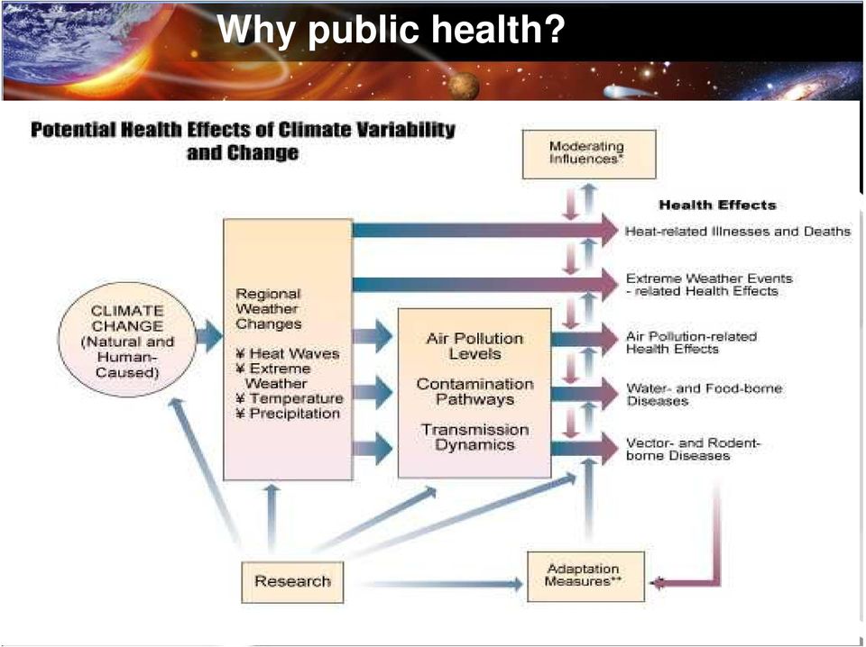
9 Why public health? 9 Patz et al.,
10 Surveillance Project: EPHTN 10

11 EPHTN/HELIX-Atlanta Provide information regarding the 5-county Metro-Atlanta Area Clayton, Cobb, DeKalb,, Fulton, & Gwinett Integrate environment & public health data into a local network that is part of a national network Take action to prevent & control environmentally related health effects 11

12 EPHTN/HELIX System Architecture 12

13 v. April 2005 Particulate Matter (PM 2.5 ) in 2003 B-Spline Surfacing Algorithm: EPHTN/HELIX NASA and the CDC are partners in linking environmental and health observations to enhance public health surveillance through the Environmental Public Health Tracking Network (EPHTN)/HELIX-Atlanta project. The integration of NASA earth science satellite observations, model predictive capabilities, and technology enhances the value of public health decision support. In the future, NASA MODIS aerosol optical depth observations will be combined with EPA monitoring data to create more representative particulate matter (PM) products. CDC Contact Pamela Meyer, DrPH, RN Science Development Team Leader National Environmental Public Health Tracking Program Centers for Disease Control & Prevention 1600 Clifton Rd, NE, MS E19 Atlanta GA NASA Program Contact John A Haynes, Program Manager Public Health Application, Applied Sciences Program NASA Headquarters MS 5L79 Washington DC Additional Earth science satellite observations, such as ozone and surface temperature, will also be used to enhance the EPHTN. Data from scattered EPA monitoring sites were used to make daily surfaces of particulate matter (PM) concentrations. High concentrations of PM are associated with adverse health reactions, eg. respiratory and cardiovascular problems. High : 50 µg/m 3 Low : 0 µg/m 3 Technical Contacts: EPA sites Doug Rickman (doug.rickman@nasa.gov) Dale Quattrochi (dale.quattrochi@nasa.gov)

14 M o d e 2 M o d e Surveillance Project: Malaria/GSAT Habitat identification Textural/contextual classifications significantly increase landcover mapping accuracy using high resolution data such as Ikonos. Identifying key factors that sustain or intensify transmission Satellite & meteor. data Microepidemiology data Risk prediction Nonparametric model computes the likelihood of disease outbreak using meteorological and epidemiological time series as input. Local environment Population database Landcover Dwelling Host behaviors Tak Pf cases Temperature (deg C) x 100 Rainfall (mm) x Vector ecology Vector control Medical care Discrete Wavelet Transform is used to differentiate confusion vegetation types. Sporozoites Oocysts Primary schizogony Hypnozoites relapses Asexual erythrocytic cycle Wavelet Transform and Hilbert-Huang Transform Empirical Mode Decomposition identify the driving variables that lead to disease outbreaks and provide more accurate predictions VECTOR Fertilization Gametocytes HUMAN Evaluated Thail military airborne data and established neural network rectification capability. blood meal oviposition eggs larvae pupae adults destroyed PARASITE pre-patent incubation delay treatment infectious relapse immunity Mode 1 M o d e Mode Spatio-temporal distribution of disease cases Mode 3 Richard.Kiang@nasa.gov 14

15 Surveillance Project: Malaria/GSAT The AFSOC GSAT will be enhanced with satellite observations from the Advanced Spaceborne Thermal Emission and Reflection Radiometry (ASTER) instrument onboard NASA Terra, the NASA Tropical Rainfall Measuring Mission (TRMM), NASA MODIS, NASA EO-1, and the Advanced Very High Resolution Radiometer (AVHRR). Other satellite observations may also be used if appropriate. According to a recent NASA Evaluation Report, enhancing the AFSOC GSAT with NASA Earth Science satellite observations and model predictive capabilities is expected to result in the following benefits for DOD: Reduced morbidity and mortality for US overseas forces and populations in host countries Almost 1/3 of US personnel involved in the 2003 Liberia operation came down with malaria Optimized utilization of larvicide and insecticide Optimized utilization of chemoprophylaxis The enhanced GSAT was tested in real military exercises such as Joint Forces Exercises (JFEX) 06 and will be tested in JFEX 08. During AFSOC preparations for JFEX 06, the NASA team transmitted certain data sets to AFSOC for use in the exercise. 15

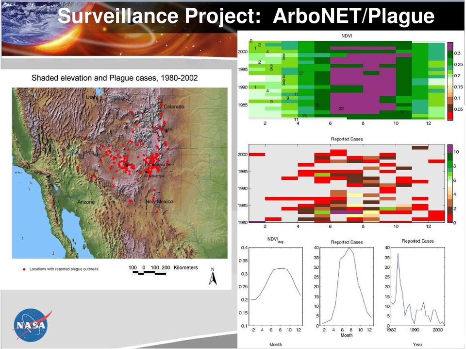
16 Surveillance Project: ArboNET/Plague Vector habitats, seasonal lifecycle variations, migration pressure from rainfall, soil moisture, vegetative cover, surface temperature, elevation, and slope. Terra Landsat 7 TRMM 16

17 Surveillance Project: ArboNET/Plague 17
18 Surveillance Project: PHAiRS/RSVP Upper Left: Dust observed from the NOAA GOES 12 satellite at 20:26 UTC on December 15, The red dashed line encircles a large dust storm occurring in west Texas. Lower Left: DREAM modeled dust concentration distribution for 20:00 UTC on December 15, 2003, before ingesting NASA MODIS land cover observations. Lower Right: DREAM modeled dust concentration distribution for 20:00 UTC on December 15, 2003, after ingesting NASA MODIS land cover observations. Note that the DREAM model much more accurately represents the NOAA GOES 12 observed dust storm after ingesting NASA Earth science satellite observations. 18

19 PHAiRS/RSVP System Architecture Terra & Aqua L1B Data T+1 hour Direct Broadcast Receiving Station (UNM CREATE) EDAC SOAP/WMS Service Req. T+7 hrs Web Client SYRIS DSS AZ and NM Air Quality and Public Health Offices EDOS MODIS L0 Data T+3-5 hours University of New Mexico Earth Data Analysis Center Initialization Parameters Dust Model Outputs T+5-7 hours GES DAAC NASA/GSFC NOAA-NWS (WRF Forecast) University of Arizona Dept. of Atmospheric Sciences 19 May 2006

20 Enhancing the RSVP/SYRIS Decision Support Tool 20

21 Projects Awarded in DECISION 04 and through the MS Research Consortium Enhancing USAID Famine and Malaria Early Warning with NASA Earth Science Results (FEWS NET/MEWS) The project's goal is to enhance USAID humanitarian programs by integrating NASA Earth observation and modeling results into famine and malaria early warning systems (FEWS NET/MEWS). PIs: James Verdin (USGS) Molly Brown (SSAI) GeoMedStat Enhance the GeoMedStat decision support tool (developed by the University of Mississippi Medical Center) for asthma surveillance, prediction, and intervention. PI: Fazlay Faruque (UMMC) 21
22 Project Selected in ROSES 05 Integration of Remote Sensing into Encephalitis Virus Intervention Decision Support Systems This project will establish procedures to directly incorporate observations and model predictive capabilities into the CDC ArboNET and the California Mosquito-borne Virus Surveillance and Response Plan (CMVSRP) from NASA satellites and ecosystem models generated by the Terrestrial Observation and Prediction System (TOPS) at NASA Ames Research Center. At a minimum, the project will utilize observations from NASA MODIS and AMSR-E, Landsat, and NOAA AVHRR. PI: William Reisen (UC-Davis) 22
23 Privacy and medical confidentiality 23
24 NASA s Public Health Partners.gov/ph.gov/rs.org.edu.int.mil 24
25 NASA Applied Sciences Program April 2004 National Aeronautics and Space Administration Earth Science Enterprise Applications Plan
26 Epidemiology in the 21 st Century 26
Suomi / NPP Mission Applications Workshop Meeting Summary
 Suomi / NPP Mission Applications Workshop Meeting Summary Westin City Center, Washington, DC June 21-22, 2012 Draft Report (updated March 12, 2013) I. Background The Suomi National Polar- orbiting Partnership
Overview of NASA Applied Remote Sensing Training Program on Water Resources and Disaster Management
 Overview of NASA Applied Remote Sensing Training Program on Water Resources and Disaster Management ARSET Applied Remote SEnsing Training A project of NASA Applied Sciences Outline About ARSET ARSET Trainings
Clouds and the Energy Cycle
 August 1999 NF-207 The Earth Science Enterprise Series These articles discuss Earth's many dynamic processes and their interactions Clouds and the Energy Cycle he study of clouds, where they occur, and
DEVELOPING WEB-BASED MAPPING SERVICES FOR PUBLIC HEALTH APPLICATIONS
 DEVELOPING WEB-BASED MAPPING SERVICES FOR PUBLIC HEALTH APPLICATIONS Amelia M. Budge a *, Karl K. Benedict a, and William Hudspeth a a EDAC, University of New Mexico, Albuquerque, NM 87131-0001, USA-(abudge,
Welcome to NASA Applied Remote Sensing Training (ARSET) Webinar Series
 Webinar Series") Welcome to NASA Applied Remote Sensing Training (ARSET) Webinar Series Introduction to Remote Sensing Data for Water Resources Management Course Dates: October 17, 24, 31 November 7, 14 Time: 8-9 a.m.
Welcome to NASA Applied Remote Sensing Training (ARSET) Webinar Series Introduction to Remote Sensing Data for Water Resources Management Course Dates: October 17, 24, 31 November 7, 14 Time: 8-9 a.m.
Amy K. Huff Battelle Memorial Institute huffa@battelle.org BUSINESS SENSITIVE 1
 Using NASA Satellite Aerosol Optical Depth Data to Create Representative PM 2.5 Fields for Use in Human Health and Epidemiology Studies in Support of State and National Environmental Public Health Tracking
Joint Polar Satellite System (JPSS)
") Joint Polar Satellite System (JPSS) John Furgerson, User Liaison Joint Polar Satellite System National Environmental Satellite, Data, and Information Service National Oceanic and Atmospheric Administration
Joint Polar Satellite System (JPSS) John Furgerson, User Liaison Joint Polar Satellite System National Environmental Satellite, Data, and Information Service National Oceanic and Atmospheric Administration
Saharan Dust Aerosols Detection Over the Region of Puerto Rico
 1 Saharan Dust Aerosols Detection Over the Region of Puerto Rico ARLENYS RAMÍREZ University of Puerto Rico at Mayagüez, P.R., 00683. Email:arlenys.ramirez@upr.edu ABSTRACT. Every year during the months
World Data Center for Remote Sensing of the Atmosphere, WDC-RSAT
 World Data Center for Remote Sensing of the Atmosphere, WDC-RSAT Michael Bittner http://wdc.dlr.de Folie 1 WDC-RSAT Mission Provide a portal for free and simplified access to atmosphere related satellite
NASA s Big Data Challenges in Climate Science
 NASA s Big Data Challenges in Climate Science Tsengdar Lee, Ph.D. High-end Computing Program Manager NASA Headquarters Presented at IEEE Big Data 2014 Workshop October 29, 2014 1 2 7-km GEOS-5 Nature Run
TECHNICAL REPORTS. Authors: Tatsuhiro Noguchi* and Takaaki Ishikawa*
 Application and Evaluation of Observation Data by Advanced Microwave Scanning Radiometer 2 Achievement of World s Top-Class Microwave Radiometer AMSR Series Authors: Tatsuhiro Noguchi* and Takaaki Ishikawa*
Data Management Framework for the North American Carbon Program
 Data Management Framework for the North American Carbon Program Bob Cook, Peter Thornton, and the Steering Committee Image courtesy of NASA/GSFC NACP Data Management Planning Workshop New Orleans, LA January
Satellite'&'NASA'Data'Intro'
 Satellite'&'NASA'Data'Intro' Research'vs.'Opera8ons' NASA':'Research'satellites' ' ' NOAA/DoD:'Opera8onal'Satellites' NOAA'Polar'Program:'NOAA>16,17,18,19,NPP' Geosta8onary:'GOES>east,'GOES>West' DMSP'series:'SSM/I,'SSMIS'
The NASA NEESPI Data Portal to Support Studies of Climate and Environmental Changes in Non-boreal Europe
 The NASA NEESPI Data Portal to Support Studies of Climate and Environmental Changes in Non-boreal Europe Suhung Shen NASA Goddard Space Flight Center/George Mason University Gregory Leptoukh, Tatiana Loboda,
A remote sensing instrument collects information about an object or phenomenon within the
 Satellite Remote Sensing GE 4150- Natural Hazards Some slides taken from Ann Maclean: Introduction to Digital Image Processing Remote Sensing the art, science, and technology of obtaining reliable information
Using Remote Sensing to Monitor Soil Carbon Sequestration
 Using Remote Sensing to Monitor Soil Carbon Sequestration E. Raymond Hunt, Jr. USDA-ARS Hydrology and Remote Sensing Beltsville Agricultural Research Center Beltsville, Maryland Introduction and Overview
NASA Earth System Science: Structure and data centers
 SUPPLEMENT MATERIALS NASA Earth System Science: Structure and data centers NASA http://nasa.gov/ NASA Mission Directorates Aeronautics Research Exploration Systems Science http://nasascience.nasa.gov/
and Data Utilization Strategy
 Japan's Earth Observation Satellite Development Plan and Data Utilization Strategy July 2005 Special Subcommittee on Earth Observation Space Activities Commission Contents 1. Introduction... 1 2. Present
Satellite derived Groundwater Storage Es4mates and Opportuni4es for Expanding Research in Arid Environments
 Satellite derived Groundwater Storage Es4mates and Opportuni4es for Expanding Research in Arid Environments NASA Ames DEVELOP Program Summer 2011 Amber Kuss, San Francisco State University William Brandt,
Analysis of Climatic and Environmental Changes Using CLEARS Web-GIS Information-Computational System: Siberia Case Study
 Analysis of Climatic and Environmental Changes Using CLEARS Web-GIS Information-Computational System: Siberia Case Study A G Titov 1,2, E P Gordov 1,2, I G Okladnikov 1,2, T M Shulgina 1 1 Institute of
II. Related Activities
 (1) Global Cloud Resolving Model Simulations toward Numerical Weather Forecasting in the Tropics (FY2005-2010) (2) Scale Interaction and Large-Scale Variation of the Ocean Circulation (FY2006-2011) (3)
ICSU/WMO World Data Center for Remote Sensing of the Atmosphere (WDC RSAT)
") ICSU/WMO World Data Center for Remote Sensing of the Atmosphere (WDC RSAT) Beate Hildenbrand (et al.) German Aerospace Center (DLR) GAW 2009, Geneva, 05 07 May 2009 http://wdc.dlr.de WDC RSAT overview
ICSU/WMO World Data Center for Remote Sensing of the Atmosphere (WDC RSAT) Beate Hildenbrand (et al.) German Aerospace Center (DLR) GAW 2009, Geneva, 05 07 May 2009 http://wdc.dlr.de WDC RSAT overview
Environmental Data Services for Delaware:
 Environmental Data Services for Delaware: Serving Emergency Responders, Planners, and Researchers Network Delaware Day November 6, 2013 Overview Operational Data Services More than just research DEOS and
USE OF GIOVANNI SYSTEM IN PUBLIC HEALTH APPLICATION
 USE OF GIOVANNI SYSTEM IN PUBLIC HEALTH APPLICATION 2 0 1 2 G R EG O RY G. L E P TO U K H O N L I N E G I OVA N N I WO R K S H O P SEPTEMBER 25, 2012 Radina P. Soebiyanto 1,2 Richard Kiang 2 1 G o d d
SATELLITE IMAGES IN ENVIRONMENTAL DATA PROCESSING
 SATELLITE IMAGES IN ENVIRONMENTAL DATA PROCESSING Magdaléna Kolínová Aleš Procházka Martin Slavík Prague Institute of Chemical Technology Department of Computing and Control Engineering Technická 95, 66
The Global Earth Observation System of Systems (GEOSS) 10-Year Implementation Plan. (As adopted 16 February 2005)
 10-Year Implementation Plan. (As adopted 16 February 2005)") The Global Earth Observation System of Systems (GEOSS) 10-Year Implementation Plan (As adopted 16 February 2005) Preamble Understanding the Earth system its weather, climate, oceans, atmosphere, water,
The Global Earth Observation System of Systems (GEOSS) 10-Year Implementation Plan (As adopted 16 February 2005) Preamble Understanding the Earth system its weather, climate, oceans, atmosphere, water,
APPLICATION OF TERRA/ASTER DATA ON AGRICULTURE LAND MAPPING. Genya SAITO*, Naoki ISHITSUKA*, Yoneharu MATANO**, and Masatane KATO***
 APPLICATION OF TERRA/ASTER DATA ON AGRICULTURE LAND MAPPING Genya SAITO*, Naoki ISHITSUKA*, Yoneharu MATANO**, and Masatane KATO*** *National Institute for Agro-Environmental Sciences 3-1-3 Kannondai Tsukuba
From Whitehall to orbit and back again: using space in government
 From Whitehall to orbit and back again: using space in government 18 th June 2014 Bristol 25 th June 2014 Liverpool 3 rd July 2014 -Newcastle Space for Smarter Government Programme (ssgp@sa.catapult.org.uk)
Example of an end-to-end operational. from heat waves
 Example of an end-to-end operational service in support to civil protection from heat waves Paolo Manunta pkt006-11-1.0 1.0_WEBGIS Athens, 8 June 2007 OUTLINE Heat Island definition and causes Heat Island
Data Management for the North American Carbon Program
 Image courtesy of NASA/GSFC Data Management for the North American Carbon Program Bob Cook, Eric Sundquist, Tom Boden,, and Peter Thornton RS in NACP Workshop Missoula, MT August 20, 2004 NACP Data and
Remote Sensing Satellite Information Sheets Geophysical Institute University of Alaska Fairbanks
 Remote Sensing Satellite Information Sheets Geophysical Institute University of Alaska Fairbanks ASTER Advanced Spaceborne Thermal Emission and Reflection Radiometer AVHRR Advanced Very High Resolution
Curriculum Material and Activities of Climate Education:
 Curriculum Material and Activities of Climate Education: Education Link Website Union of Concerned Scientists develop the global warming: Early Warning Signs Map a science-based world map depicting the
Forest Fire Information System (EFFIS): Rapid Damage Assessment
: Rapid Damage Assessment") Forest Fire Information System (EFFIS): Fire Danger D Rating Rapid Damage Assessment G. Amatulli, A. Camia, P. Barbosa, J. San-Miguel-Ayanz OUTLINE 1. Introduction: what is the JRC 2. What is EFFIS 3.
Forest Fire Information System (EFFIS): Fire Danger D Rating Rapid Damage Assessment G. Amatulli, A. Camia, P. Barbosa, J. San-Miguel-Ayanz OUTLINE 1. Introduction: what is the JRC 2. What is EFFIS 3.
U.S. COMMERCIAL REMOTE SENSING POLICY. April 25, 2003 FACT SHEET
 U.S. COMMERCIAL REMOTE SENSING POLICY April 25, 2003 FACT SHEET The President authorized a new national policy on April 25, 2003 that establishes guidance and implementation actions for commercial remote
Development of an Integrated Data Product for Hawaii Climate
 Development of an Integrated Data Product for Hawaii Climate Jan Hafner, Shang-Ping Xie (PI)(IPRC/SOEST U. of Hawaii) Yi-Leng Chen (Co-I) (Meteorology Dept. Univ. of Hawaii) contribution Georgette Holmes
Public Health 101 Series
 Public Health 101 Series Introduction to Public Health Informatics Instructor name Title Organization Note: This slide set is in the public domain and may be customized as needed by the user for informational
Integrated Risk Management System Components in the GEO Architecture Implementation Pilot Phase 2 (AIP-2)
") Meraka Institute ICT for Earth Observation PO Box 395 Pretoria 0001, Gauteng, South Africa Telephone: +27 12 841 3028 Facsimile: +27 12 841 4720 University of KwaZulu- Natal School of Computer Science
Meraka Institute ICT for Earth Observation PO Box 395 Pretoria 0001, Gauteng, South Africa Telephone: +27 12 841 3028 Facsimile: +27 12 841 4720 University of KwaZulu- Natal School of Computer Science
Severe Weather & Hazards Related Research at CREST
 Severe Weather & Hazards Related Research at CREST (Lead Scientists) Z. Johnny Luo, Nir Krakauer, Shayesteh Mahani, Fabrice Papa, Marouane Temimi and Brian Vant Hull (NOAA Collaborators) Arnold Gruber,
History of satellites, and implications for hurricanes monitoring and forecasting
 History of satellites, and implications for hurricanes monitoring and forecasting Pat Fitzpatrick Mississippi State University With assistance from Lisa Fitzpatrick 1 Precursor to U.S. Weather Satellite
Update on EUMETSAT ocean colour services. Ewa J. Kwiatkowska
 Update on EUMETSAT ocean colour services Ewa J. Kwiatkowska 1 st International Ocean Colour Science meeting, 6 8 May, 2013 EUMETSAT space data provider for operational oceanography Operational data provider
High Resolution Information from Seven Years of ASTER Data
 High Resolution Information from Seven Years of ASTER Data Anna Colvin Michigan Technological University Department of Geological and Mining Engineering and Sciences Outline Part I ASTER mission Terra
Climate Change Long Term Trends and their Implications for Emergency Management August 2011
 Climate Change Long Term Trends and their Implications for Emergency Management August 2011 Overview A significant amount of existing research indicates that the world s climate is changing. Emergency
16 th IOCCG Committee annual meeting. Plymouth, UK 15 17 February 2011. mission: Present status and near future
 16 th IOCCG Committee annual meeting Plymouth, UK 15 17 February 2011 The Meteor 3M Mt satellite mission: Present status and near future plans MISSION AIMS Satellites of the series METEOR M M are purposed
COASTAL MONITORING & OBSERVATIONS LESSON PLAN Do You Have Change?
 Coastal Change Analysis Lesson Plan COASTAL MONITORING & OBSERVATIONS LESSON PLAN Do You Have Change? NOS Topic Coastal Monitoring and Observations Theme Coastal Change Analysis Links to Overview Essays
Urban Ecosystem Analysis Atlanta Metro Area Calculating the Value of Nature
 August 2001 Urban Ecosystem Analysis Atlanta Metro Area Calculating the Value of Nature Report Contents 2 Project Overview and Major Findings 3 Regional Analysis 4 Local Analysis 6 Using Regional Data
CLOUD MASKING AND CLOUD PRODUCTS ROUNDTABLE EXPECTED PARTICIPANTS: ACKERMAN, HALL, WAN, VERMOTE, BARKER, HUETE, BROWN, GORDON, KAUFMAN, SCHAAF, BAUM
 CLOUD MASKING AND CLOUD PRODUCTS ROUNDTABLE EXPECTED PARTICIPANTS: ACKERMAN, HALL, WAN, VERMOTE, BARKER, HUETE, BROWN, GORDON, KAUFMAN, SCHAAF, BAUM NOMINAL PURPOSE: DISCUSSION OF TESTS FOR ACCURACY AND
The Impact of Climate Change on Vector-Borne Infectious Diseases. Namasha Schelling. Graduate Research Paper
 The Impact of Climate Change on Vector-Borne Infectious Diseases Namasha Schelling Graduate Research Paper Global Climate Change: The Science, Social Impact and Diplomacy of a World Environmental Crisis
Global environmental information Examples of EIS Data sets and applications
 METIER Graduate Training Course n 2 Montpellier - february 2007 Information Management in Environmental Sciences Global environmental information Examples of EIS Data sets and applications Global datasets
The Global Distribution of Mineral Dust
 The Global Distribution of Mineral Dust Ina Tegen Leibniz Institute for f r Tropospheric ric Research, Leipzig, Germany Barcelona, November 07, 2007 Dust Effects Role of dust in global climate forcing
Global Earth Observation Integrated Data Environment (GEO-IDE) Presentation to the Data Archiving and Access Requirements Working Group (DAARWG)
 Presentation to the Data Archiving and Access Requirements Working Group (DAARWG)") Global Earth Observation Integrated Data Environment (GEO-IDE) Presentation to the Data Archiving and Access Requirements Working Group (DAARWG) Ken McDonald Data Management Integration Architect National
Global Earth Observation Integrated Data Environment (GEO-IDE) Presentation to the Data Archiving and Access Requirements Working Group (DAARWG) Ken McDonald Data Management Integration Architect National
Satellite SST Product Development Proposal
 Call for Proposals under the IMOS (EIF) Five Year Strategy: Enhancement or extension of IMOS July 2009 to June 2013 Satellite SST Products Sub-Facility Plan Overview: Proposed Infrastructure Investment:
Ensuring the Preparedness of Users: NOAA Satellites GOES R, JPSS Laura K. Furgione
 Ensuring the Preparedness of Users: NOAA Satellites GOES R, JPSS Laura K. Furgione U.S. Permanent Representative with the WMO Deputy Director, NOAA s s National Weather Service WMO Executive Council 65
Presented by Gary Davis, Director, Office of Systems Development NOAA/NESDIS/OSD. Fifty Years of Achievement
 NOAA s Environmental Satellite Program: Past, Present, and Future Presented by Gary Davis, Director, Office of Systems Development NOAA/NESDIS/OSD 1 Space-Based Remote Sensors Changed Way We See Our World
Land Use/Land Cover Map of the Central Facility of ARM in the Southern Great Plains Site Using DOE s Multi-Spectral Thermal Imager Satellite Images
 Land Use/Land Cover Map of the Central Facility of ARM in the Southern Great Plains Site Using DOE s Multi-Spectral Thermal Imager Satellite Images S. E. Báez Cazull Pre-Service Teacher Program University
AAFC Medium-Resolution EO Data Activities for Agricultural Risk Assessment
 AAFC Medium-Resolution EO Data Activities for Agricultural Risk Assessment North American Drought Monitor (NADM) Ottawa, Ontario, Canada. October 15-17 2008. A. Davidson 1, A. Howard 1,2, K. Sun 1, M.
Review for Introduction to Remote Sensing: Science Concepts and Technology
 Review for Introduction to Remote Sensing: Science Concepts and Technology Ann Johnson Associate Director ann@baremt.com Funded by National Science Foundation Advanced Technological Education program [DUE
GOSIC NEXRAD NIDIS NOMADS
 NOAA National Climatic Data Center GOSIC NEXRAD NIDIS NOMADS Christina Lief NOAA/NESDIS/NCDC GOSIC Program Manager NOAA/NESDIS/NCDC Asheville, NC 28801 GEOSS AIP Phase 2 Workshop September 25-26, 2008
Cloud detection and clearing for the MOPITT instrument
 Cloud detection and clearing for the MOPITT instrument Juying Warner, John Gille, David P. Edwards and Paul Bailey National Center for Atmospheric Research, Boulder, Colorado ABSTRACT The Measurement Of
THE STRATEGIC PLAN OF THE HYDROMETEOROLOGICAL PREDICTION CENTER
 THE STRATEGIC PLAN OF THE HYDROMETEOROLOGICAL PREDICTION CENTER FISCAL YEARS 2012 2016 INTRODUCTION Over the next ten years, the National Weather Service (NWS) of the National Oceanic and Atmospheric Administration
NCDC s SATELLITE DATA, PRODUCTS, and SERVICES
 **** NCDC s SATELLITE DATA, PRODUCTS, and SERVICES Satellite data and derived products from NOAA s satellite systems are available through the National Climatic Data Center. The two primary systems are
Overview on Namibian Flood SensorWeb Pilot Project stuart.frye@nasa.gov October 22, 2009
 Overview on Namibian Flood SensorWeb Pilot Project stuart.frye@nasa.gov October 22, 2009 1 Goal is to visualize available satellite data and possible future satellite data in an area of interest and a
Slide 1. Slide 2. Slide 3
 Satellite Analysis of Sea Surface Temperatures in the Florida Keys to Monitor Coral Reef Health NASA Stennis Space Center Earthzine/DEVELOP Virtual Poster Session, Summer 2011 Video Transcript Slide 1
Chairman Boxer, Senator Inhofe, Senator Alexander and Members of the Committee, I am
 Statement of Susan R. Cooper, MSN, RN, Commissioner, Tennessee Department of Health Before the United States Senate Environmental Public Works Committee October 23, 2007 Representing the Association of
NASA Applied Sciences Program: Water Resources Application Area
 NASA and the California Department of Water Resources Remote Sensing for Drought Monitoring and Response Workshop NASA Applied Sciences Program: Water Resources Application Area 25-26 Feb 2014 Sacramento,
Cloud-based Geospatial Data services and analysis
 Cloud-based Geospatial Data services and analysis Xuezhi Wang Scientific Data Center Computer Network Information Center Chinese Academy of Sciences 2014-08-25 Outlines 1 Introduction of Geospatial Data
163 ANALYSIS OF THE URBAN HEAT ISLAND EFFECT COMPARISON OF GROUND-BASED AND REMOTELY SENSED TEMPERATURE OBSERVATIONS
 ANALYSIS OF THE URBAN HEAT ISLAND EFFECT COMPARISON OF GROUND-BASED AND REMOTELY SENSED TEMPERATURE OBSERVATIONS Rita Pongrácz *, Judit Bartholy, Enikő Lelovics, Zsuzsanna Dezső Eötvös Loránd University,
New challenges of water resources management: Title the future role of CHy
 New challenges of water resources management: Title the future role of CHy by Bruce Stewart* Karl Hofius in his article in this issue of the Bulletin entitled Evolving role of WMO in hydrology and water
Coastal Research Proposal Abstracts
 Coastal Research Proposal Abstracts An Automated Data Analysis, Processing, and Management System Proposal to NASA with SAIC Total Budget $15K Submitted 10/31/2008 The goal of this study is to design,
Climatology and Monitoring of Dust and Sand Storms in the Arabian Peninsula
 Climatology and Monitoring of Dust and Sand Storms in the Arabian Peninsula Mansour Almazroui Center of Excellence for Climate Change Research (CECCR) King Abdulaziz University, Jeddah, Saudi Arabia E-mail:
Basic Climatological Station Metadata Current status. Metadata compiled: 30 JAN 2008. Synoptic Network, Reference Climate Stations
 Station: CAPE OTWAY LIGHTHOUSE Bureau of Meteorology station number: Bureau of Meteorology district name: West Coast State: VIC World Meteorological Organization number: Identification: YCTY Basic Climatological
IMPACTS OF IN SITU AND ADDITIONAL SATELLITE DATA ON THE ACCURACY OF A SEA-SURFACE TEMPERATURE ANALYSIS FOR CLIMATE
 INTERNATIONAL JOURNAL OF CLIMATOLOGY Int. J. Climatol. 25: 857 864 (25) Published online in Wiley InterScience (www.interscience.wiley.com). DOI:.2/joc.68 IMPACTS OF IN SITU AND ADDITIONAL SATELLITE DATA
Geospatial Software Solutions for the Environment and Natural Resources
 Geospatial Software Solutions for the Environment and Natural Resources Manage and Preserve the Environment and its Natural Resources Our environment and the natural resources it provides play a growing
U.S. Geological Survey Earth Resources Operation Systems (EROS) Data Center
 Data Center") U.S. Geological Survey Earth Resources Operation Systems (EROS) Data Center World Data Center for Remotely Sensed Land Data USGS EROS DATA CENTER Land Remote Sensing from Space: Acquisition to Applications
U.S. Geological Survey Earth Resources Operation Systems (EROS) Data Center World Data Center for Remotely Sensed Land Data USGS EROS DATA CENTER Land Remote Sensing from Space: Acquisition to Applications
Jessica Blunden, Ph.D., Scientist, ERT Inc., Climate Monitoring Branch, NOAA s National Climatic Data Center
 Kathryn Sullivan, Ph.D, Acting Under Secretary of Commerce for Oceans and Atmosphere and NOAA Administrator Thomas R. Karl, L.H.D., Director,, and Chair of the Subcommittee on Global Change Research Jessica
Assessing Hurricane Katrina Damage to the Mississippi Gulf Coast Using IKONOS Imagery
 Assessing Hurricane Katrina Damage to the Mississippi Gulf Coast Using IKONOS Imagery Joseph P. Spruce Science Systems and Applications, Inc. John C., MS 39529 Rodney McKellip NASA Project Integration
Matsu: An Elastic Cloud Connected to a SensorWeb for Disaster. (Session 12F Working Group: Cloud Computing for Spacecraft Operations)
") Matsu: An Elastic Cloud Connected to a SensorWeb for Disaster Response (Session 12F Working Group: Cloud Computing for Spacecraft Operations) Daniel Mandl - NASA/GSFC 3/2/11 1 SensorWeb High Level Architecture
Matsu: An Elastic Cloud Connected to a SensorWeb for Disaster Response (Session 12F Working Group: Cloud Computing for Spacecraft Operations) Daniel Mandl - NASA/GSFC 3/2/11 1 SensorWeb High Level Architecture
Earth remote sensing systems of middle and low resolution
 Earth remote sensing systems of middle and low resolution Serial on-line remote sensing satellites delivering data available on the world market V.I. Gershenzon (ScanEx R&D Center) In 1980, graduated from
Very High Resolution Arctic System Reanalysis for 2000-2011
 Very High Resolution Arctic System Reanalysis for 2000-2011 David H. Bromwich, Lesheng Bai,, Keith Hines, and Sheng-Hung Wang Polar Meteorology Group, Byrd Polar Research Center The Ohio State University
http://www.isac.cnr.it/~ipwg/
 The CGMS International Precipitation Working Group: Experience and Perspectives Vincenzo Levizzani CNR-ISAC, Bologna, Italy and Arnold Gruber NOAA/NESDIS & Univ. Maryland, College Park, MD, USA http://www.isac.cnr.it/~ipwg/
Daily High-resolution Blended Analyses for Sea Surface Temperature
 Daily High-resolution Blended Analyses for Sea Surface Temperature by Richard W. Reynolds 1, Thomas M. Smith 2, Chunying Liu 1, Dudley B. Chelton 3, Kenneth S. Casey 4, and Michael G. Schlax 3 1 NOAA National
The USGS Landsat Big Data Challenge
 The USGS Landsat Big Data Challenge Brian Sauer Engineering and Development USGS EROS bsauer@usgs.gov U.S. Department of the Interior U.S. Geological Survey USGS EROS and Landsat 2 Data Utility and Exploitation
CHAPTER 2 Energy and Earth
 CHAPTER 2 Energy and Earth This chapter is concerned with the nature of energy and how it interacts with Earth. At this stage we are looking at energy in an abstract form though relate it to how it affect
FACTS ABOUT CLIMATE CHANGE
 FACTS ABOUT CLIMATE CHANGE 1. What is climate change? Climate change is a long-term shift in the climate of a specific location, region or planet. The shift is measured by changes in features associated
National Snow and Ice Data Center A brief overview and data management projects
 Cooperative Institute for Research in Environmental Sciences University of Colorado National Snow and Ice Data Center A brief overview and data management projects Walt Meier, Mark Parsons, and Mark Serreze
Selecting the appropriate band combination for an RGB image using Landsat imagery
 Selecting the appropriate band combination for an RGB image using Landsat imagery Ned Horning Version: 1.0 Creation Date: 2004-01-01 Revision Date: 2004-01-01 License: This document is licensed under a
The Balance of Power in the Earth-Sun System
 NASA Facts National Aeronautics and Space Administration www.nasa.gov The Balance of Power in the Earth-Sun System The Sun is the major source of energy for Earth s oceans, atmosphere, land, and biosphere.
THE NATIONAL SPACE WEATHER PROGRAM
 1 Office of the Federal Coordinator for Meteorological Services and Supporting Research (OFCM) THE NATIONAL SPACE WEATHER PROGRAM Committee on Solar and Space Physics National Research Council Space Studies
Integrated Global Carbon Observations. Beverly Law Prof. Global Change Forest Science Science Chair, AmeriFlux Network Oregon State University
 Integrated Global Carbon Observations Beverly Law Prof. Global Change Forest Science Science Chair, AmeriFlux Network Oregon State University Total Anthropogenic Emissions 2008 Total Anthropogenic CO 2
Distributed Computing. Mark Govett Global Systems Division
 Distributed Computing Mark Govett Global Systems Division Modeling Activities Prediction & Research Weather forecasts, climate prediction, earth system science Observing Systems Denial experiments Observing
NCDC Strategic Vision
 NOAA s National Climatic Data Center World s Largest Archive of Climate and Weather Data Presented to: Coastal Environmental Disasters Data Management Workshop September 16, 2014 Stephen Del Greco Deputy
CIESIN Columbia University
 Conference on Climate Change and Official Statistics Oslo, Norway, 14-16 April 2008 The Role of Spatial Data Infrastructure in Integrating Climate Change Information with a Focus on Monitoring Observed
ESA Climate Change Initiative contributing to the Global Space-based Architecture for Climate Monitoring
 ESA Climate Change Initiative contributing to the Global Space-based Architecture for Climate Monitoring Pascal Lecomte Head of the ESA Climate Office ESA/ECSAT Global Space-based Architecture for Climate
ENVIRONMENTAL MONITORING Vol. I - Remote Sensing (Satellite) System Technologies - Michael A. Okoye and Greg T. Koeln
 System Technologies - Michael A. Okoye and Greg T. Koeln") REMOTE SENSING (SATELLITE) SYSTEM TECHNOLOGIES Michael A. Okoye and Greg T. Earth Satellite Corporation, Rockville Maryland, USA Keywords: active microwave, advantages of satellite remote sensing, atmospheric
REMOTE SENSING (SATELLITE) SYSTEM TECHNOLOGIES Michael A. Okoye and Greg T. Earth Satellite Corporation, Rockville Maryland, USA Keywords: active microwave, advantages of satellite remote sensing, atmospheric
Climate Change: A Local Focus on a Global Issue Newfoundland and Labrador Curriculum Links 2010-2011
 Climate Change: A Local Focus on a Global Issue Newfoundland and Labrador Curriculum Links 2010-2011 HEALTH Kindergarten: Grade 1: Grade 2: Know that litter can spoil the environment. Grade 3: Grade 4:
Precipitation Remote Sensing
 Precipitation Remote Sensing Huade Guan Prepared for Remote Sensing class Earth & Environmental Science University of Texas at San Antonio November 14, 2005 Outline Background Remote sensing technique
A Microwave Retrieval Algorithm of Above-Cloud Electric Fields
 A Microwave Retrieval Algorithm of Above-Cloud Electric Fields Michael J. Peterson The University of Utah Chuntao Liu Texas A & M University Corpus Christi Douglas Mach Global Hydrology and Climate Center
CNES Strategy for Health and the Environment
 1 CNES Strategy for Health and the Environment Murielle LAFAYE, Coordinator of CNES Applications Team Co-lead GEO CoP Health and the Environment CEOS SBA Health Coordinator 2 CNES Tele-Health Programme
[ Climate Data Collection and Forecasting Element ] An Advanced Monitoring Network In Support of the FloodER Program
![[ Climate Data Collection and Forecasting Element ] An Advanced Monitoring Network In Support of the FloodER Program](/thumbs/33/16326315.jpg "[ Climate Data Collection and Forecasting Element ] An Advanced Monitoring Network In Support of the FloodER Program") [ Climate Data Collection and Forecasting Element ] An Advanced Monitoring Network In Support of the FloodER Program December 2010 1 Introduction Extreme precipitation and the resulting flooding events
[ Climate Data Collection and Forecasting Element ] An Advanced Monitoring Network In Support of the FloodER Program December 2010 1 Introduction Extreme precipitation and the resulting flooding events
Proposals of Summer Placement Programme 2015
 Proposals of Summer Placement Programme 2015 Division Project Title Job description Subject and year of study required A2 Impact of dual-polarization Doppler radar data on Mathematics or short-term related
Landsat Monitoring our Earth s Condition for over 40 years
 Landsat Monitoring our Earth s Condition for over 40 years Thomas Cecere Land Remote Sensing Program USGS ISPRS:Earth Observing Data and Tools for Health Studies Arlington, VA August 28, 2013 U.S. Department