Preliminary Plan for Expansion of the Regional Network of Floridan and Surficial Aquifer Monitor Wells for Northern Tampa Bay
|
|
|
- Oliver Cameron
- 8 years ago
- Views:
Transcription
1 DRAFT - August 24, 2000 Preliminary Plan for Expansion of the Regional Network of Floridan and Surficial Aquifer Monitor Wells for Northern Tampa Bay Introduction In 1999, the Southwest Florida Water Management District began the process of developing a Scope of Work for a series of projects designed to continue assessments of the biologic and hydrologic systems in the Northern Tampa Bay area. These projects will be designed primarily to support the ongoing development of minimum flows and levels, water resources recovery, water use permitting, and environmental resource permitting. The series of projects, referred to as the Northern Tampa Bay Phase II program (or NTB II), will advance work performed during the Northern Tampa Bay Water Resources Assessment Project (NTB WRAP). The NTB WRAP, completed in 1996, was a comprehensive effort to better understand the water resources of the area, as well as to provide the foundation for future, more detailed, hydrogeologic and biologic studies. One of the most important components of NTB II will be the water level monitoring network for the area. Water level data in the Floridan and surficial aquifer, as well as in lakes and wetlands, will be needed to support a variety of assessments, including: 1) the development of future minimum flows and levels, 2) the assessment of the status of lakes and wetlands with already established minimum levels, 3) the assessment of existing minimum flows and level methodologies, 4) assessment of water level recovery as existing ground-water withdrawals in regional public supply wellfields are decreased via the Partnership Plan, and 5) the monitoring of new and existing permits for all use types. As the existing network of water level monitoring stations is assessed, and new sites are proposed, all the potential uses of the data must be considered. The following outlines a proposal for expansion of the Floridan aquifer water level monitoring network in the Northern Tampa Bay area. Separate reports will present the plan addressing lakes and wetlands. A review of the existing network of Floridan aquifer monitor wells found that while the coverage of monitor wells within wellfield areas is very good, there are large gaps in areas in between and surrounding wellfields that have little to no aquifer monitoring. The objective of the plan is primarily to fill in large gaps where no monitor wells currently exist, both in areas believed to currently have significant drawdowns in the Floridan and surficial aquifers (to measure existing impact and future recovery), and areas where little drawdown is believed to currently exist (for possible use as control areas). Existing monitor wells within the District s Water Management Database were considered in the assessment, and are shown on the accompanying figures. When available, well construction information for the existing wells was considered. Monitor
, will advance work performed during the Northern Tampa Bay Water Resources Assessment Project (NTB WRAP).")
2 DRAFT - August 24, 2000 wells in the Regulatory Database were also reviewed, although the future reliability of these wells are questionable since they are controlled by the permit holders. Although the locations of these wells were considered, especially those controlled by Tampa Bay Water, only monitor wells in the Water Management Database are being considered as part of this Floridan aquifer monitoring network at this stage in the assessment. All of the following sites are proposed to consist of both a Floridan aquifer and surficial aquifer monitoring well. Figure 1 presents all of the proposed monitor well sites. As a reference, the September 1997 potentiometric surface is also shown on each figure. Hernando/North Pasco County area Figure 2 presents the location of four well nests proposed for the Hernando/North Pasco County area. All four well locations were selected to fill large gaps in the existing network. The three western-most sites are proposed along relatively flat areas of the Floridan aquifer potentiometric surface. All three are located in an area of relatively low known Floridan aquifer drawdown, although few high quality monitor wells exist in the area, and a better definition of drawdown may be estimated with the new wells. These wells will also provide refined information on water level fluctuations in the area. The eastern-most site in Figure 2 is proposed along the northern end of the Pasco High. The Pasco High is an important feature in the potentiometric surface of the Northern Tampa Bay area, yet few quality monitor wells exist along the Pasco High to clearly define its extent. Therefore, this well will allow a better definition of the extent and shape of the northern reaches of the High, as well as fill in a large data gap. Cypress Creek Wellfield area Figure 3 presents the location of ten well nests proposed for the Cypress Creek wellfield area. Nine of the sites are located to the east of the Cypress Creek Wellfield area. The western-most site is proposed along US 41. This site was chosen to fill in a large spatial data gap, as well as to provide another well nest located in an area of relatively little Floridan aquifer drawdown. The precise location was chosen based on the potential to located the site on Pasco County property. If it is not possible to locate the well on this property, it may be desirable to construct the well slightly to the south.

3 DRAFT - August 24, 2000 Seven sites are located immediately to the east of the Cypress Creek wellfield. Although drawdown has been predicted to be somewhat extensive in this area (as confirmed by observations in wetland health), no District Floridan aquifer monitors exist in the area. These wells will be key indicators of recovery in the area of the Cypress Creek wellfield, as well as provide an improved measurement of the potentiometric surface in the area. The proposed sites were located approximately along the four and eight foot drawdown contours as predicted by the Northern Tampa Bay Ground-Water Model, although the actual well sites will vary depending on site access. The two eastern-most well sites are located along the southern end of the Pasco High. These well sites were chosen for similar reasons as the previously discussed site on the northern end of the Pasco High. New River Area Figure 4 presents the three well sites proposed for the New River area. The New River basin is a significant sub-basin of the Hillsborough River watershed, but no Floridan aquifer monitor wells exist in the area. The District is committed to developing minimum flows and levels in the Hillsborough River Basin by 2005, and an adequate coverage of monitor wells will be necessary to fully evaluate the hydrologic system within the watershed. Three well sites are proposed in the New River basin for purposes of spatial coverage of the region, as well as future minimum flows and levels assessment. Eastern Hillsborough County area Figure 5 presents the four well sites proposed for the eastern Hillsborough County area. With the exception of a few ROMP wells, wells recently installed on the Cone Ranch property (located in the northeast corner of Hillsborough County), and wells installed as part of a recent Crystal Springs study, there are few Floridan aquifer monitor wells in this area. Two of the proposed sites are located to the west of the Cone Ranch property, and a third is proposed to the east of the property in Polk County. Wells at these sites would provide water level data in a region of few monitor wells in the Hillsborough River Basin, and can serve as monitor wells if the Cone Ranch property becomes a regional water supply source. A fourth site is proposed in the headwaters of the Hillsborough River, likely to be placed on District-owned property. Few monitor wells exist in this region.

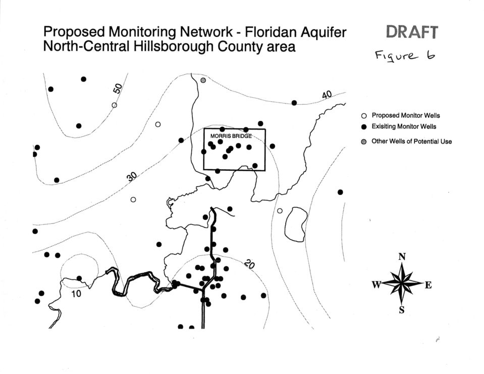
4 DRAFT - August 24, 2000 North-Central Hillsborough County area Figure 6 presents three well sites proposed for the north-central Hillsborough County area. All three well sites are proposed in areas where no monitor wells currently exist. Two wells are proposed to the west of the Morris Bridge wellfield, within the lower Cypress Creek watershed. The third well is proposed in the area of Lake Thonotosassa, which will provide aquifer monitoring in a large area where no monitor well sites exist. NW Hillsborough County area Figure 7 presents one well site proposed for the NW Hillsborough County area. This is an area that was targeted for new aquifer monitor sites during the Northern Tampa Bay Water Resource Assessment Project, and has relatively good coverage of aquifer monitor sites. One new well site is proposed in the vicinity of Lake Alice, to fill a relatively large area where no monitor well sites currently exist. Lake Alice is located in area between two wellfields, Cosme-Odessa and Eldridge-Wilde, and has shown impacts to water levels over many years. A nested well site in this area will provide valuable information on the relationship between Lake Alice and the underlying aquifers, as well as help quantify drawdown and recovery in this inter-wellfield area.

5

6

7

8

9

10
11

RESTRICTING GROUNDWATER WITHDRAWALS TO PROTECT WATER RESOURCES: ECONOMIC IMPACT ASSESSMENT
 CHAPTER 14 RESTRICTING GROUNDWATER WITHDRAWALS TO PROTECT WATER RESOURCES: ECONOMIC IMPACT ASSESSMENT Grace Johns and Lisa A. McDonald Economic analysis methods have been used in Florida to identify positive
Recovery Analysis for Northern Tampa Bay September 7, 2005
 Recovery Analysis for Northern Tampa Bay September 7, 2005 Recovery Overview Statutes and District Rules Other types of Recovery assessments District activities performed gearing up for 2010 Types of analyses
;# $%&!)+6'!*+,&!.-!0**&12(3!4<!(17.//&7')=!+!2>*)(7+'&!.-!:2-34&#&56& 7<9!5+6!/&*)+7&2!5('%!'%&!7.//&7'!:2-34&7&56&7#9!!!!!
+6'!*+,&!.-!0**&12(3!4<!(17.//&7')=!+!2>*)(7+'&!.-!:2-34&#&56& 7<9!5+6!/&*)+7&2!5('%!'%&!7.//&7'!:2-34&7&56&7#9!!!!!") !!!"#$%&'()*+$&'),-&).+#$/"()0'&+)1&2"3&'4)!$'+$&546)7+'2%)899:) ) ;''+$+) ) "# $%&!'(')&!*+,&!-./!0**&12(3!4!2+'&!5+6!7.//&7'&2!+12!7%+1,&2! -/.8!!"#$$%&'()*+,-.-/0"9!'.!:"#$$#&'()*+,-.-/01119!! ;# $%&!)+6'!*+,&!.-!0**&12(3!4
!!!"#$%&'()*+$&'),-&).+#$/"()0'&+)1&2"3&'4)!$'+$&546)7+'2%)899:) ) ;''+$+) ) "# $%&!'(')&!*+,&!-./!0**&12(3!4!2+'&!5+6!7.//&7'&2!+12!7%+1,&2! -/.8!!"#$$%&'()*+,-.-/0"9!'.!:"#$$#&'()*+,-.-/01119!! ;# $%&!)+6'!*+,&!.-!0**&12(3!4
Update on Aquifer Storage and Recovery
 Update on Aquifer Storage and Recovery Dean Powell Bureau Chief Water Supply Bureau Governing Board Workshop September 2013 Objectives Discuss the basics of aquifer storage and recovery (ASR) technology
West-Central Florida Water Restoration Action Plan Report to the Legislature
 West-Central Florida Water Restoration Action Plan Report to the Legislature Southwest Florida Water Management District Photo courtesy Jim Phillips March 2010 Report to the Legislature Table of Contents
Governing Board Meeting
 \ Governing Board Meeting Agenda July 28, 2015 9:00 AM 7601 US Hwy. 301 Tampa, Florida ( ) - 2379 Broad Street, Brooksville, Florida 34604-6899 (352) 796-7211 or 1-800-423-1476 (FL only) WaterMatters.org
Foundation Underpinning Process and Relationship with Groundwater in West- Central Florida
 Foundation Underpinning Process and Relationship with Groundwater in West- Central Florida Ahmed Said, PhD, PE Principal Engineering Consultant, Sinkhole Geotech, Inc. e-mail: admin@sinkholegeotech.com
Peace River Basin Resource Management Plan - Action Items Status Report for the Peace River Basin Management Advisory Committee Meeting
 Peace River Basin Resource Management Plan - Action Items Status Report for the Peace River Basin Management Advisory Committee Meeting December 2010, Mid-Meeting Update (October 15, 2010) In its Peace
ORGANIZATIONAL ONLINE SURVEY RESULTS EXECUTIVE SUMMARY
 Stakeholder Advisory Committee ORGANIZATIONAL ONLINE SURVEY RESULTS EXECUTIVE SUMMARY AUGUST 2012 Compiled and Summarized by: Facilitating Consensus Solutions, Supporting Collaborative Action. The Florida
Proposed Review Process for the Northern Tampa Bay Phase II Program and Minimum Flows and Levels Methodologies
 Proposed Review Process for the Northern Tampa Bay Phase II Program and Minimum Flows and Levels Methodologies In 1999, the District initiated the Northern Tampa Bay Phase II program (NTB II) as a follow-up
Susan Iott U. S. General Accounting Office. Restoration of the South Florida Ecosystem
 Susan Iott U. S. General Accounting Office Restoration of the South Florida Ecosystem Presented at The Aspen Global Change Institute June 5-10, 2003 Summer Science Session I Learning from Regions: A Comparative
WILLOCHRA BASIN GROUNDWATER STATUS REPORT 2009-10
 WILLOCHRA BASIN GROUNDWATER STATUS REPORT 2009-10 SUMMARY 2009-10 The Willochra Basin is situated in the southern Flinders Ranges in the Mid-North of South Australia, approximately 50 km east of Port Augusta
1 INTRODUCTION. Kayenta Complex Page 9 December 2011 Cumulative Hydrologic Impact Assessment
 1 INTRODUCTION The Office of Surface Mining Reclamation and Enforcement (OSMRE) is the regulatory authority for coal mining operations under the Surface Mining Reclamation and Control Act of 1977 that
AGENDA ITEM C9. COST/FUNDING SOURCE: $431,847.40/ Uniform Rate
 AGENDA ITEM C9 DATE: February 2, 2015 TO: FROM: SUBJECT: Matt Jordan, General Manager Charles Carden, Chief Operating Officer South Pasco Transmission Main Condition Assessment Services with Pure Technologies
COMMENTS ON THE CADIZ CONSERVATION, RECOVERY, AND STORAGE PROJECT DRAFT ENVIRONMENTAL IMPACT REPORT
 March 13, 2012 Attn: Tom Barnes, ESA 626 Wilshire Boulevard, Ste. 1100 Los Angeles, CA 90017 Telephone: 213-599- 4300 Fax: 213-599- 4301 COMMENTS ON THE CADIZ CONSERVATION, RECOVERY, AND STORAGE PROJECT
Development of Conservation and Restoration Targets for Sustainable Water Resource Management Mike Britt, Natural Resources Division Director
 Development of Conservation and Restoration Targets for Sustainable Water Resource Management Mike Britt, Natural Resources Division Director September 2012 FINAL Table of contents Section Pages 1. Introduction
FY 2015-16 Springs Funding Projects
 FY 2015-16 Springs Funding Projects Spring Homosassa Springs Project Name and Description Garcia Point Septic Project: Through the connection of 88 residential septic systems to Citrus County s central
Creating a Sustainable Water Supply for Central Florida
 CKN'll'RAL KLGR&A WATER N i'atvk- A KKGGNA K. RXSPONSK 'll'g AVGD A PXNBNC CRSS By: 1Mlcllaae D. Mztom, Zsq. DZA,N ViZADi XGZRTGN ELOGDWGR't'E &APOUZ&NO a~~ ibgzar H P A, 2 z!ckgr~omm@ Central Florida
Comprehensive Plan for Unincorporated Hillsborough County Revised 7/24/14 Final Conservation & Aquifer Recharge Element - Crosswalk
 Critical Findings Hillsborough County is currently designated as an attainment area for 4 out of the 6 criteria pollutants. This attainment area designation means that the County meets national and state
River Basin Management in Croatia
 River Basin Management in Croatia 2. INTERNATIONAL RIVER BASIN MANAGEMENT HIGH LEVEL SYMPOSIUM Cappadocia/NEVŞEHİR, Turkey 16-18 April 2013 2 Water sector responsibilities are shared among: Croatian Parliament
Walla Walla Bi state Stream Flow Enhancement Study Interim Progress Report. Department of Ecology Grant No. G1400656.
 Walla Walla Bi state Stream Flow Enhancement Study Interim Progress Report Department of Ecology Grant No. G1400656 Submitted by: Walla Walla Watershed Management Partnership Walla Walla, WA Walla Walla
March 2008. Prepared by: Irvine Ranch Water District. 15600 Sand Canyon Avenue. Irvine, CA 92618. Contact: Natalie Likens (949) 453-5633
 453-5633") ADDENDUM TO THE MICHELSON WATER RECLAMATION PLANT PHASE 2 & 3 CAPACITY EXPANSION PROJECT FEBRUARY 2006 FINAL ENVIRONMENTAL IMPACT REPORT AND THE SAN JOAQUIN FRESHWATER MARSH ENHANCEMENT PLAN REVISED SEPTEMBER
ADDENDUM TO THE MICHELSON WATER RECLAMATION PLANT PHASE 2 & 3 CAPACITY EXPANSION PROJECT FEBRUARY 2006 FINAL ENVIRONMENTAL IMPACT REPORT AND THE SAN JOAQUIN FRESHWATER MARSH ENHANCEMENT PLAN REVISED SEPTEMBER
A Long-Range Plan: Melbourne s Drinking Water Supply
 April 2002 A Long-Range Plan: Melbourne s Drinking Water Supply The long-term water supply of South Brevard County must be dependable, flexible, and affordable. With those goals in mind, we continue to
Everglades Restoration: Federal Funding and Implementation Progress
 Everglades Restoration: Federal Funding and Implementation Progress Charles V. Stern Specialist in Natural Resources Policy November 18, 2014 Congressional Research Service 7-5700 www.crs.gov R42007 Summary
INNOVATION IN FLOW RESTORATION AND WATER BANKING CASE STUDY: DUNGENESS WATER EXCHANGE
 INNOVATION IN FLOW RESTORATION AND WATER BANKING CASE STUDY: DUNGENESS WATER EXCHANGE Amanda Cronin Washington Water Trust AWRA- Washington State Conference September 26, 2013 WASHINGTON WATER TRUST Washington
Thurston County Water Utility Purveyor Technical Workgroup Meeting October 31, 2012 Mike Gallagher Water Resources Program Southwest Regional Office
 A challenging mitigation of surface water impacts from projected long term well pumping for three separate cities located in the Nisqually and Deschutes Watersheds Thurston County Water Utility Purveyor
FLORIDA ATLANTIC UNIVERSITY
 9 Supporting Data The purpose of the Element is to ensure the provision of public facilities and services required to meet the future needs of the University, including: Stormwater management, to protect
ARIZONA DEPARTMENT OF WATER RESOURCES
 ARIZONA DEPARTMENT OF WATER RESOURCES WATER MANAGEMENT REQUIREMENTS FOR SOLAR POWER PLANTS IN ARIZONA ADWR CONTACT: Jeff Tannler, Statewide Active Management Area Director Arizona Department of Water Resources
Preliminary Assessment
 Preliminary Assessment Bonebrake Theological Seminary Site Dayton Unit III Dayton, Ohio Prepared by: U.S. Army Corps of Engineers Buffalo District 1776 Niagara Street Buffalo, NY 14207-3199 September 5,
The HIGH SPEED RAIL THREAT to LOS ANGELES DRINKING WATER
 The HIGH SPEED RAIL THREAT to LOS ANGELES DRINKING WATER INTRODUCTION On December 2 nd, 2014, the High Speed Rail (HSR) Project released new maps showing recently proposed alternate rail routes that go
DISTRICT VALUES STATEMENTS, GOALS, ACTION ITEMS, AND ONGOING TASKS FOR 2015 Adopted by the Board of Directors December 10, 2014. Values Statements.
 DISTRICT VALUES STATEMENTS, GOALS, ACTION ITEMS, AND ONGOING TASKS FOR 2015 Adopted by the Board of Directors December 10, 2014 Values Statements. The Board opposes any new transfers of water from the
Plan Groundwater Procurement, Implementation and Costs, prepared for the Brazos River Authority, July 2005.
 6 Conjunctive Use 6.1 Lake Granger Augmentation 6.1.1 Description of Option Rapid population growth and development in Williamson County require additional water supplies throughout the planning period.
2011 MAJOR PROJECTS UPDATE - EAST WELLFIELD EXPANDED HYDROGEOLOGICAL STUDY AND WASTEWATER TREATMENT PLANT ZERO IMPACT ANALYSIS
 Council November 28, 2011 2011 MAJOR PROJECTS UPDATE - EAST WELLFIELD EXPANDED HYDROGEOLOGICAL STUDY AND WASTEWATER TREATMENT PLANT ZERO IMPACT ANALYSIS ISSUE As a component of the Town s 2011 Major Projects
DOCKET NO. D-2004-008-2 DELAWARE RIVER BASIN COMMISSION. Southeastern Pennsylvania Ground Water Protected Area
 This DRAFT docket has been prepared for the purposes of the scheduled public hearing and may be substantially modified as a result of the public hearing process prior to Commission action. 8/26/2013 4:17
How To Manage Water Resources In The Yakima Basin
 Yakima Basin Integrated Water Resource Management Plan October 23, 2014 Presented by Derek Sandison, Director Office of Columbia River Photo Courtesy of Tom Ring Basin size: 6,155 sq. miles Population:
511 Tampa Bay. www.511tampabay.com WINNER. 2005 Best of ITS Award Best Public Private Partnership Awarded by ITS America on May 2, 2005
 Tampa Bay SunGuide District Seven s Future in Intelligent Transportation Systems Presented at: FACERS June 22, 2005 Tampa, FL Tampa Bay SunGuide Freeway 511 System Management System Covers 750 miles of
Everglades Restoration Progress
 S O U T H F L O R I D A W A T E R M A N A G E M E N T D I S T R I C T Everglades Progress JANUARY 2016 BACKGROUND: America s Everglades was once a vibrant, free-flowing River of Grass, extending from the
City of London Climate Change Adaptation Strategy Dealing with Extreme Rainfall Events
 City of London Climate Change Adaptation Strategy Dealing with Extreme Rainfall Events May 29, 2014 Presented by: Berta Krichker M.Eng., FEC, P.Eng. Manager of Stormwater Unit Environmental and Engineering
Tampa Bay Water (A Regional Water Supply Authority) Year Ended September 30, 2015 With Reports of Independent Certified Public Accountants
 Year Ended September 30, 2015 With Reports of Independent Certified Public Accountants") F INANCIAL S TATEMENTS, R EQUIRED S UPPLEMENTARY I NFORMATION, AND C OMPLIANCE S ECTION Tampa Bay Water Year Ended September 30, 2015 With Reports of Independent Certified Public Accountants Ernst & Young
F INANCIAL S TATEMENTS, R EQUIRED S UPPLEMENTARY I NFORMATION, AND C OMPLIANCE S ECTION Tampa Bay Water Year Ended September 30, 2015 With Reports of Independent Certified Public Accountants Ernst & Young
9.1. Adequacy of Available Data and Monitoring Efforts
 9. DATA MANAGEMENT Data management is a crucial aspect of successful implementation of the ARB IRWMP and its component projects. This section discusses the adequacy of available data and monitoring efforts,
General Frost-Freeze FAQs
 General Frost-Freeze FAQs Groundwater Pumping: 1) Why do farmers use water to protect their crops during frost-freeze events? a. During frost-freeze events, farmers spray water onto their crops to protect
Harris - Galveston Subsidence District
 Harris - Galveston Subsidence District History of Subsidence, Regulation, and Water Management in the Houston Region Michael J. Turco - General Manager ASSOCIATION OF WATER BOARD DIRECTORS GUEST LECTURE
Florida s 2011 Metropolitan Statistical Area (MSA) Exports to the World Updated October 2012
 Exports to the World Updated October 2012") Florida s 2011 Metropolitan Statistical Area (MSA) Exports to the World Updated October 2012 Enterprise Florida, Inc. International Trade & Development 201 Alhambra Circle, Suite 610 Coral Gables, Florida
Florida s 2011 Metropolitan Statistical Area (MSA) Exports to the World Updated October 2012 Enterprise Florida, Inc. International Trade & Development 201 Alhambra Circle, Suite 610 Coral Gables, Florida
Fort Dodge Stormwater Master Planning. Prepared By: Ralph C. Stark, Jr., P.E., C.F.M. Joel N. Krause, P.E., C.F.M.
 Fort Dodge Stormwater Master Planning Prepared By: Ralph C. Stark, Jr., P.E., C.F.M. Joel N. Krause, P.E., C.F.M. Project Location Project Background Flooding History Localized flooding and storm sewer
4. Priority Areas of Conservation
 4. Priority Areas of Conservation A. SIGNIFICANT RESOURCE AREAS This Open Space and Farmland Plan identifies the key issues facing open space and agricultural resources in the Town, highlights the location
RECOMMENDATION DISCUSSION:
 AGENDA ITEM I1 DATE: June 2, 2014 TO: Matt Jordan, General Manager FROM: Alison Adams, Chief Technical Officer SUBJECT: Comprehensive Asset Management Program - Status Report and Presentation SUMMARY:
EU China River Basin Management Programme
 Ministry of Water Resources Ministry of Environmental Protection EU China River Basin Management Programme Technical Report 075 Water Resource Supply Security Strategy Analysis Ben Piper, Zhang Wang and
Clearwater s Groundwater Replenishment Program
 Clearwater s Groundwater Replenishment Program. Potable Reuse for Florida: A Full Day Workshop for Elected Officials Orlando, FL March 22, 2013 Nan Benne(, P.E. Public U2li2es Assistant Director City of
CALIFORNIA AMERICAN WATER LOS ANGELES DISTRICT 2009 GENERAL RATE CASE CHAPTER: 1 INTRODUCTION AND SUMMARY OF APPLICATION
 DISCUSSION OF INFORMATION PRESENTED IN THIS CHAPTER This chapter contains information regarding the operation of the Los Angeles District of California American Water as well as tables that summarize the
GROUNDWATER CONDITIONS
 GROUNDWATER CONDITIONS IN THE NORTHERN SACRAMENTO VALLEY LOCAL MANAGEMENT OF WATER RESOURCES IN THE NORTHERN SACRAMENTO VALLEY MEETING DECEMBER 16, 2011 KELLY STATON, SENIOR ENGINEERING GEOLOGIST, GROUNDWATER
SRS Maps. Site Sampling Locations Doses Groundwater
 SRS Maps Site Sampling Locations Doses Groundwater Savannah River Site Environmental Report for 2003 SRTC Map Figure 1 The Savannah River Site SRS is located in South Carolina, about 12 miles south of
FINAL REPORT Increase of Water Supply Safety by Managed Aquifer Recharge along the North-South Carrier A pre-feasibility study
 FINAL REPORT Increase of Water Supply Safety by Managed Aquifer Recharge along the North-South Carrier A pre-feasibility study ANDREAS LINDHE, LARS ROSÉN, PER-OLOF JOHANSSON, TOMMY NORBERG Department of
Community Level Planning: Lessons Learned NIDIS NDMC EPC Workshop June 8, 2011 Chicago Jeff Brislawn and Courtney Peppler
 Community Level Planning: Lessons Learned NIDIS NDMC EPC Workshop June 8, 2011 Chicago Jeff Brislawn and Courtney Peppler COLORADO MUNICIPAL DROUGHT MANAGEMENT PLAN Guidance Document 2 2010 Update to Drought
AQUIFER STORAGE RECOVERY
 AQUIFER STORAGE RECOVERY This continuing education unit has been created to acquaint the reader with the topic of Aquifer Storage Recovery. The International School of Well Drilling gratefully acknowledges
A GIS BASED GROUNDWATER MANAGEMENT TOOL FOR LONG TERM MINERAL PLANNING
 A GIS BASED GROUNDWATER MANAGEMENT TOOL FOR LONG TERM MINERAL PLANNING Mauro Prado, Hydrogeologist - SRK Consulting, Perth, Australia Richard Connelly, Principal Hydrogeologist - SRK UK Ltd, Cardiff, United
Stacey Harrington, M.S, R.E.H.S. Napa County Environmental Management Coordinator
 Stacey Harrington, M.S, R.E.H.S. Napa County Environmental Management Coordinator How many people view the Napa County regions: How groundwater management folks see Napa County Brief History During the
Water-Table and Potentiometric-Surface Altitudes in the Upper Glacial, Magothy, and Lloyd Aquifers Beneath Long Island, New York, April May 2010
 Prepared in cooperation with the Nassau County Department of Public Works, the New York City Department of Environmental Protection, the New York State Department of Environmental Conservation, the Suffolk
Prostate Cancer: Stage of Disease at Diagnosis
 Bear River Health District 14% 3% 61% Bear River Health District 481 61.3 7830 64.5 173 22.0 2611 21.54% 23 2.93% 638 5.26% 107 13.6 1043 8. 40.6% 48. Bear River Health District Central Health District
PROJECT AGREEMENT FOR MENINDEE LAKES PROJECT MANAGEMENT
 PROJECT AGREEMENT FOR MENINDEE LAKES PROJECT MANAGEMENT Council of Australian Governments An agreement between the Commonwealth of Australia and New South Wales The outputs of this project will be the
Pinellas-Anclote River Basin. Projects
 Pinellas-Anclote River Basin Projects June 2010 Table of Contents BasinBookReport-FY2010 v2.7 Production may 21 test2 strat init... 1 Z010 - Boards & Executive Services - Pinellas-Anclote River Basin...
LR 314 Working Group 5 Final Report
 LR 314 Working Group 5 Final Report I. Nebraska Department of Natural Resources Table 1. NDNR and NATURAL RESOURCES COMMISSION WATER/INTEGRATED MANAGEMENT PLANNING RELATED RESEARCH, STUDIES AND RELATED
THE DUNGENESS WATER EXCHANGE. Washington Water Trust March 13, 2013 Sequim Realtors
 THE DUNGENESS WATER EXCHANGE Washington Water Trust March 13, 2013 Sequim Realtors PRESENTATION OVERVIEW Who is the Washington Water Trust? What is the Dungeness Water Exchange? How does the Exchange provide
WATER: ENVIRONMENTAL SCIENCE Syllabus
 WATER: ENVIRONMENTAL SCIENCE Syllabus Course Title Water: Environmental Science Course Description Central to all ecosystems, water is essential to life as we know it. It shapes our planet on every level,
SPDES PRIVATE, COMMERCIAL, INSTITUTIONAL GENERAL PERMIT FOR SANITARY WASTEWATER DISCHARGES TO GROUNDWATER FACT SHEET
 SPDES PRIVATE, COMMERCIAL, INSTITUTIONAL GENERAL PERMIT FOR SANITARY WASTEWATER DISCHARGES TO GROUNDWATER FACT SHEET for Permit No. GP-0-15-001 Issued Pursuant to Article 17, Titles 7, 8 and Article 70
North Branch Chicago River Watershed-Based Plan
 North Branch Chicago River Watershed-Based Plan EXECUTIVE SUMMARY In Lake County, the Lake County Stormwater Management Commission (SMC) is responsible for managing Lake County s water resources. The North
Water Extraction Permitting Policy
 Water Extraction Policy 1 Water Extraction Permitting Policy Department of Environment, Labour & Justice January 2013 Water Extraction Policy 2 EXECUTIVE SUMMARY This document establishes a new policy
Florida. Information Technology Industry. Source: Florida Agency for Workforce Innovation, Bureau of Labor Market Statistics Center
 L a b o r M a r k e t I n d u s t r y P r o f i l e Florida Information Technology Industry Source: Florida Agency for Workforce Innovation, Bureau of Labor Market Statistics Center Florida Information
Florida s 2013 Metropolitan Statistical Area (MSA) Exports to the World
 Exports to the World") Florida s 2013 Metropolitan Statistical Area (MSA) Exports to the World Updated December 2014 Enterprise Florida, Inc. International Trade & Development 201 Alhambra Circle, Suite 610 Coral Gables, Florida
Florida s 2013 Metropolitan Statistical Area (MSA) Exports to the World Updated December 2014 Enterprise Florida, Inc. International Trade & Development 201 Alhambra Circle, Suite 610 Coral Gables, Florida
Early Head Start (Serving Pregnant Women and Children Birth to Age 3)
") Alachua Baker Episcopal Children's Services Head Start/Early Head Start 8443 Baymeadows Rd. Suite 1 Jacksonville, Florida 32256 (904) 726-1500 Ext. 236 Bay Brevard Early Education and Care, Inc. Head Start/Early
Alachua Baker Episcopal Children's Services Head Start/Early Head Start 8443 Baymeadows Rd. Suite 1 Jacksonville, Florida 32256 (904) 726-1500 Ext. 236 Bay Brevard Early Education and Care, Inc. Head Start/Early
Nutrient Reduction by Use of Industrial Deep Injection Wells, Miami-Dade County, Florida
 GWPC September 27, 2015 Nutrient Reduction by Use of Industrial Deep Injection Wells, Miami-Dade County, Florida Virginia Walsh, PhD, P.G. Miami-Dade Water and Sewer Department Ed Rectenwald, P.G. MWH
North Central Florida Regional Planning Council
 North Central Florida Regional Planning Council 1 North Central Florida Strategic Regional Policy Plan Steven Dopp, Senior Planner Regional Planning June 12, 2015 2 Overview What is a Strategic Regional
3. The submittal shall include a proposed scope of work to confirm the provided project description;
 QIN Shoreline Master Program Project Summary The Shoreline Master Program (SMP) development process for the Quinault Indian Nation (QIN) includes the completion of inventory and analysis report with corresponding
Integrated Modeling and Data Management for Complex Stormwater Management Systems
 Integrated Modeling and Data Management for Complex Stormwater Management Systems Peter J. Singhofen Streamline Technologies, Inc. Photo Source: SWFWMD What is Meant by Integrated? Numerical Integration?
Withlacoochee. Waccasassa. Ocklawaha River Basin SWFWMD SWFWMD. Functional Loss Credits. Temporary Clearing PFO 0.05 0.05 Fill PFO 0.18 0.
 TABLE RAI-5 SUMMARY OF COMPENSATORY MITIGATION REQUIREMENTS BY BASIN (3.7.16) Facility/ Wetland SRWMD Upper Suwannee SRWMD Lower Suwannee SRWMD Santa Fe SRWMD SRWMD by ERP Withlacoochee Upper River Basin
Develop and Implement a Pilot Status and Trend Monitoring Program for Salmonids and their Habitat in the Wenatchee and Grande Ronde River Basins.
 Project ID: 35019 Title: Develop and Implement a Pilot Status and Trend Monitoring Program for Salmonids and their Habitat in the Wenatchee and Grande Ronde River Basins. Response to ISRP Comments A. This
Proposed Minimum and Guidance Levels for Lake Clinch in Polk County, Florida
 Proposed Minimum and Guidance Levels for Lake Clinch in Polk County, Florida December 2, 2015 Draft Resource Evaluation Section Water Resources Bureau Proposed Minimum and Guidance Levels for Lake Clinch
Florida. Information Technology Industry. 2015 Edition. Source: Florida Department of Economic Opportunity, Bureau of Labor Market Statistics
 L a b o r M a r k e t I n d u s t r y P r o f i l e Florida Information Technology Industry 2015 Edition Source: Florida Department of Economic Opportunity, Bureau of Labor Market Statistics Florida Information
Comprehensive Plan Drainage Subelement
 Comprehensive Plan Drainage Subelement Adopted January 26, 2010 Ordinance 210-19 Prepared by: CITY OF POMPANO BEACH 100 West Atlantic Boulevard Pompano Beach, Florida 33060 Telephone: 954.786.4600 website:
Funding for this project provided by Washington Department of Ecology Grants G1200126 & G0700149
 Funding for this project provided by Washington Department of Ecology Grants G1200126 & G0700149 Table of Contents Executive Summary.. 3 Introduction.. 4 Disaggregation of tive & Non-tive Water Use 5 Publicly
5.14 Floodplains and Drainage/Hydrology
 I-70 East Final EIS 5.14 Floodplains and Drainage/Hydrology 5.14 Floodplains and Drainage/Hydrology This section discusses floodplain and drainage/hydrology resources and explains why they are important
Cost of Service Studies For the San Antonio, California Water District
 REQUEST FOR PROPOSALS TO PROVIDE: CONSULTING SERVICES TO THE SAN LORENZO VALLEY WATER DISTRICT PROJECT TITLE: ENTERPRISE WIDE COST OF SERVICE FINANCIAL STUDY RESPONSE DUE BEFORE 3:00 P.M. ON JANUARY 15,
Water Security Agency. Plan for 2015-16. saskatchewan.ca
 Water Security Agency Plan for 2015-16 saskatchewan.ca Statement from the Minister I am pleased to present the Water Security Agency s Plan for 2015-16. The Honourable Scott Moe Minister Responsible for
edms 8. AUSTRALIA 8.1 Water Resources Management Policies and Actions
 8. AUSTRALIA 8.1 Water Resources Management Policies and Actions In Australia, an Intergovernmental Agreement for a National Water Initiative (NWI) was signed by the Australian Government, all state and
Allan, J. D. 1995. Stream Ecology: Structure and Function of Running Waters. Chapman and Hall, New York. 388 pp.
 REFERENCES Allan, J. D. 1995. Stream Ecology: Structure and Function of Running Waters. Chapman and Hall, New York. 388 pp. Barnes, J. H. and W. D. Sevon. 1996. The Geological Story of Pennsylvania. Pennsylvania
Remote Sensing, GPS and GIS Technique to Produce a Bathymetric Map
 Remote Sensing, GPS and GIS Technique to Produce a Bathymetric Map Mark Schnur EES 5053 Remote Sensing Fall 2007 University of Texas at San Antonio, Department of Earth and Environmental Science, San Antonio,
Waters of the State CALIFORNIA
 Waters of the State CALIFORNIA Waters of the State What are waters of the state? What is California s response to SWANCC and Rapanos? How has the 9 th Circuit responded to SWANCC and Rapanos? Waters of
Supply and Demand Correlation New Mexico Gila Basin Arizona Water Settlement Act
 Supply and Demand Correlation New Mexico Gila Basin Arizona Water Settlement Act 1. 2. U.S. Department of the Interior Bureau of Reclamation Phoenix Area Office December 2010 Mission Statements The mission
ALABAMA INSURANCE UNDERWRITING ASSOCIATION COMMERCIAL LINES
 ADDITIONAL RULE(S) Wind-Only Policy If desired, a policy covering only the peril of Windstorm or Hail may be issued on an eligible Commercial risk. (Plan of Operation and Rules and Procedures for Submitting
CDM. City of Jacksonville Master Stormwater Management Plan (MSMP) Update. December 2008 Update. Agenda. 1. Data Collection. 2.
 Update. December 2008 Update. Agenda. 1. Data Collection. 2.") City of Jacksonville Master Stormwater Management Plan (MSMP) Update December 2008 Update CDM Agenda 1. Data Collection 1. GIS/LiDAR 2. Survey 2. Water Quantity 1. SWMM Modeling 2. FEMA 3. Water Quality
City of Jacksonville Master Stormwater Management Plan (MSMP) Update December 2008 Update CDM Agenda 1. Data Collection 1. GIS/LiDAR 2. Survey 2. Water Quantity 1. SWMM Modeling 2. FEMA 3. Water Quality
SECTION 9 SUMMARY OF COORDINATION, PUBLIC VIEWS AND COMMENTS
 SECTION 9 SUMMARY OF COORDINATION, PUBLIC VIEWS AND COMMENTS This page intentionally left blank. 9.0SUMMARY OF COORDINATION, PUBLIC VIEWS AND COMMENTS 9.1 PUBLIC OUTREACH AND PUBLIC INVOLVEMENT Public
PHI 2014 Q2 ECONSULT SOLUTIONS, INC. PHILADELPHIA HOUSING INDEX
 INDEX PHI 2014 Q2 Quarterly Index 1 Sales by Price per Square Foot. 2 Sales Volume by Price Range..3 Statistics by District.. 4 Quarterly Index by Subregion.. 5 Background and Notes.... 6 QUARTERLY INDEX
Municipal Water District of Orange County. Regional Urban Water Management Plan
 Municipal Water District of Orange County Regional Urban Water Management Plan Municipal Water District of Orange County Water Reliability Challenges and Solutions Matt Stone Associate General Manager
Ouachita River Floodplain Restoration Upper Ouachita NWR, Louisiana
 Ouachita River Floodplain Restoration Upper Ouachita NWR, Louisiana Interior Hydrologic Restoration Plan Mollicy Farms Unit The Nature Conservancy Louisiana Field Office 2011 Cover: Sediment laden water
Technical Documentation to Support Development of Minimum Flows and Levels for the Caloosahatchee River and Estuary
 Caloosahatchee River and Estuary MFL Document DRAFT 09/07/00 7:56 AM Technical Documentation to Support Development of Minimum Flows and Levels for the Caloosahatchee River and Estuary South Florida Water
Mission. Department Description. Our Values
 GAS SYSTEM Mission To serve the natural and propane (LP) gas needs of the customers in the Clearwater and surrounding Florida Suncoast area in the most safe, reliable and economical manner possible while
The National Integrated Drought Information System. The NIDIS Implementation Team www.drought.gov
 The National Integrated Drought Information System The NIDIS Implementation Team www.drought.gov National Integrated Drought Information System No systematic collection and analysis of social, environmental,
STANDARDS FOR RANGELAND HEALTH ASSESSMENT FOR SAGEHEN ALLOTMENT #0208
 STANDARDS FOR RANGELAND HEALTH ASSESSMENT FOR SAGEHEN ALLOTMENT #0208 RANGELAND HEALTH STANDARDS - ASSESSMENT SAGEHEN ALLOTMENT #0208 STANDARD 1 - UPLAND WATERSHED This standard is being met on the allotment.
REQUEST FOR PROPOSALS
 REQUEST FOR PROPOSALS LOWER GREAT MIAMI RIVER NUTRIENT MANAGEMENT PROJECT INTRODUCTION On behalf of a partnership of Water Resource Recovery Facilities (WRRFs) WRRFs and other stakeholders with permitted
Marketing and Information Department 390 North Orange Ave., Suite 1300 Orlando, FL 32801 407/316-4500 Fax: 407/316-4599 PARTNER INFORMATION
 Marketing and Information Department 390 North Orange Ave., Suite 1300 Orlando, FL 32801 407/316-4500 Fax: 407/316-4599 PARTNER INFORMATION Small Business Administration 7A Loan Guarantee Program How It
Appendix A. Lists of Accomplishments and Project Costs. UMRWD 10 Year Plan Update. Appendix A UPPER MINNESOTA RIVER WATERSHED DISTRICT
 UPPER MINNESOTA RIVER WATERSHED DISTRICT Lists of Accomplishments and Project Costs 10 Year Plan Update UMRWD 10 Year Plan Update Page A 1 UMRWD LIST OF ACCOMPLISHMENTS Since its inception in 1967, the