Infrastructure, Effects on reindeer behaviour experiences from Finland
|
|
|
- Jonah Townsend
- 8 years ago
- Views:
Transcription
1 Infrastructure, Effects on reindeer behaviour experiences from Finland Alfred Colpaert Department of Geography and Historical Studies University of Eastern Finland


2 Research history Pasture inventory 1995 Land use questions 2000 Effects of Infrastructure 2005 Finnish Game and Fisheries Research Institute, Reindeer research Jouko Kumpula Marja Anttonen Timo Kumpula Ari Tanskanen

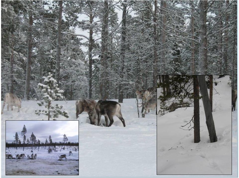
3 Finnish reindeer herd summer winter

4 Landsat TM 1987 satellite image Finnish Norwegian border Norway Finland

5

6 Pasture classification

7
8
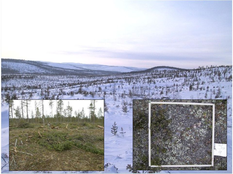
9 Change in forest landscape Grid cells(0,5 x 0,5 km) with at least 40 % mature or old growth forest N = N = Change19 %

10 GPS tracking of reindeer Research districts Reindeer position with GPS-collar 1-3 times / day (8 hour interval) Ivalo, female reindeer locations Oraniemi, female reindeer locations

11 GPS locations and yearly habitat (MCP) Ivalo district

12 Infrastructure Point - house Line - road Area- camping

13 Study of impact of infrastructure We studied seven forms of infrastructure Build up areas Buildings Main roads Forest roads Skiing trails Snowmobile tracks Gold digging areas We tested buffers of 100, 400 and 1500 meter around the infrastructure (2500 m for population centers).

14 Method We used the Aebisher s Compositional Analysis On two spatial scales Home range selection Within home range selection Three seasonal periods Early winter (Nov Jan) Late winter (Feb April) Summer autumn (May Oct)
 Late winter (Feb April) Summer autumn (May")
15 Effects of infrastructure Building stage traffic, noise, dust. High level of disturbance. Period of adjustment, regeneration of vegetation and landscape. Possible spreading of infrastructure. Increasing levels of disturbance. Habitat loss and fragmentation. Combined effects of different infrastructure. Functional habitat loss

16 Disturbance Effects can be measured up to 1500 meter. Differences between season. Differences between vegetation zones.

17 Photos : Jouko Kumpula

18 Infrastructure forming networks, fragmenting and reducing pasture value Map: Gold digging areas, Saariselkä area (Metsähallitus 2004)

19 Infrastructure Home range selection Avoidance distance (m) Potential area affected (% of the land area) Within-home-range selection Avoidance Potential area distance (m) affected (% of the land area) Early winter: Population centres ,2 2500* 5,2 Buildings , ,5 Main roads , ,2 roads ** Snowmobile tracks ,3 0 0 Skiing trails Gold digging areas Total area affected 27,5 (709,6 km 2 ) 16,9 (436,2 km 2 ) Late winter: Population centres ,2 2500* 5,2 Buildings ,8 0 0 Main roads , ,0 roads Snowmobile tracks , ,3 Skiing trails ,3 1500* 8,3 Gold digging areas ,9 0 0 Total area affected 39,0 (1004,5 km 2 ) 20,3 (524,0 km 2 ) Summer-autumn: Population centres , ,2 Buildings , ,5 Main roads , ,0 roads Snowmobile tracks Skiing trails Gold digging areas ,9 0 0 Total area affected 30,7 (790,3 km 2 ) 7,2 (185,8 km 2 )
 20,3 (524,0 km 2 ) Summer-autumn: Population centres")
20 Infrastructure coverage- and influence areas

21 Ivalo infrastructure
22 Infrastructure, coverage and affected area.
23 Mudd usjä rven paliskun ta In arijärvi Pa atsjoe n paliskunta Ivalo district N ellim Ha mmastun tu rin paliskun ta Ivalo Ke väjärvi Tsa rm itu nturin eräma a Indeksia rvo (malli 3, kesä) -3 Grid map indicating usability of pasture in relation to natural and human conditions (Määttä, M. 2004) -2-1 Törm änen Tie t Ha mma stun turin erä maa Saariselkä U rho Kekkosen kansallispu isto Lapin paliskunta ³ km Maria Määttä Maantieteen laitos Ou lun yliopisto GPS locations Summer index Mudd usjä rven paliskun ta Pa atsjoe n paliskunta In arijärvi N ellim Ha mmastun tu rin paliskun ta Ke väjärvi Tsa rm itu nturin eräma a In deksia rvo (malli 1, talvi) Ivalo Törm änen Tie t Ha mma stun turin erä maa km Saariselkä U rho Kekkosen kansallispu isto Lapin paliskunta ³ Maria Määttä Maantieteen laitos Ou lun yliopisto Winter index
24 Mining New Kevitsa Ni ja Cu open pit mine, Sodankylä. Mine needs new bridge, road and power line. rigin=rss
25
26 Kevitsa Mining area 14.8 km m buffer 8.7 km 2
27 Tracking period
28 Caribou Wind Farm, Quebec, Canada
29 Conclusions There is no green energy. Development should be concentrated Restrict infrastructure spreading. Optimize not only for profit, but also for landscape and environment. Fair compensation
30 References Kumpula, J., Colpaert, A. & Anttonen, M. 2007: Does forest harvesting and linear infrastructure change the usability value of pastureland for semi-domesticated reindeer (Rangifer tarandus tarandus). Annales Zoologici Fennici 44: Kumpula, J & Colpaert, A. 2007: Snow conditions and usability value of pastureland for semi-domesticated reindeer (Rangifer tarandus tarandus) in northern boreal forest area. Rangifer 27 (1): Kumpula, J., Colpaert, A. & Tanskanen, A. 2008: Porojen laidunten valinta muuttuneessa metsä- ja maisemarakenteessa Keski- Lapissa. Suomen Riista 54: Anttonen, M., Kumpula, J. & Colpaert, A.: Range selection by semidomesticated reindeer (Rangifer tarandus tarandus) in relation to infrastructure and human activity in boreal forest environment, northern Finland. Manuscript
31 The end
Effects of a holiday resort on the distribution of semidomesticated
 Ann. Zool. Fennici 49: 23 35 ISSN 3-455X (print), ISSN 1797-245 (online) Helsinki 2 April 212 Finnish Zoological and Botanical Publishing Board 212 Effects of a holiday resort on the distribution of semidomesticated
Reindeer herding and land use management Nordic perspectives
 NJF s Nordic reindeer husbandry seminar 2014 Reindeer herding and land use management Nordic perspectives When: 19-21 October 2014 Where: Arctic Centre, University of Lapland, Rovaniemi, Finland TENTATIVE
Objectives. Raster Data Discrete Classes. Spatial Information in Natural Resources FANR 3800. Review the raster data model
 Spatial Information in Natural Resources FANR 3800 Raster Analysis Objectives Review the raster data model Understand how raster analysis fundamentally differs from vector analysis Become familiar with
Woodland caribou (Rangifer tarandus caribou) in the Far North of Ontario: Background information in support of land use planning
 in the Far North of Ontario: Background information in support of land use planning") Woodland caribou (Rangifer tarandus caribou) in the Far North of Ontario: Background information in support of land use planning The Far North Caribou Project (FNCP) was initiated in 2008 to support land
Woodland caribou (Rangifer tarandus caribou) in the Far North of Ontario: Background information in support of land use planning The Far North Caribou Project (FNCP) was initiated in 2008 to support land
Land Use/ Land Cover Mapping Initiative for Kansas and the Kansas River Watershed
 Land Use/ Land Cover Mapping Initiative for Kansas and the Kansas River Watershed Kansas Biological Survey Kansas Applied Remote Sensing Program April 2008 Previous Kansas LULC Projects Kansas LULC Map
Adapting to climate change: Tourism and recreation
 Adapting to climate change: Tourism and recreation Eija Pouta University of Helsinki Department of Forest Economics Marjo Neuvonen & Tuija Sievänen Finnish Forest Research Institute (METLA) Previous studies

Forest Fire Research in Finland
 International Forest Fire News (IFFN) No. 30 (January June 2004, 22-28) Forest Fire Research in Finland Effective wildfire suppression and diminished use of prescribed burning in forestry has clearly eliminated
Transitions in herd management of semi-domesticated reindeer in northern Finland
 Ann. Zool. Fennici 45: 81 11 ISSN 3-455X (print), ISSN 1797-245 (online) Helsinki 29 April 28 Finnish Zoological and Botanical Publishing Board 28 Transitions in herd management of semi-domesticated reindeer
TFL 55 CHANGE MONITORING INVENTORY SAMPLE PLAN
 TFL 55 CHANGE MONITORING INVENTORY SAMPLE PLAN Prepared for: Mike Copperthwaite, RPF Louisiana-Pacific Canada Ltd. Malakwa, BC Prepared by: Timberline Natural Resource Group Ltd. Kamloops, BC Project Number:
The Fram Centre Research in the high north under innovative structure
 The Fram Centre Research in the high north under innovative structure December 2014 Nina Mari Jørgensen, Norwegian Polar Institute Photo: Jo Aarseth, Kongsfjorden, Svalbard August 2013 Governmental support
Inari Saariselkä Region. Northern Lapland Tourism Ltd
 Northern Lapland Tourism Ltd Location Location and connections Saariselkä s 260 km north of the Arctic Circle 200 km south of the Arctic Ocean 28 km south of Ivalo Airport Distances 70 km to Inari Village
Finding a Sustainable Management Strategy for the Tongass National Forest Opportunities and Challenges
 Finding a Sustainable Management Strategy for the Tongass National Forest Opportunities and Challenges Prepared by D.R. Systems NW Inc. For the SouthEast Conference Defining Sustainability Successful Achievement
Changes of coniferous timber and tree lines in Finnish Lapland during 1983-2009
 Workshop Silviculture in Changing Environment November 24-25, 2014 Kirkkonummi, Finland Changes of coniferous timber and tree lines in Finnish Lapland during 1983-2009 Anna Franke, Pasi Aatsinki, Ville
BIOMASS SUPPLY CHAIN MANAGEMENT AND CONTROLLING
 BIOMASS SUPPLY CHAIN MANAGEMENT AND CONTROLLING FOCUS AND CONTENT The focus of the presentation is on forest biomass in Central Finland Content Entities of the forest biomass demand and supply chain Forest
Revising the Nantahala and Pisgah Land Management Plan Preliminary Need to Change the Existing Land Management Plan
 Revising the Nantahala and Pisgah Land Management Plan Preliminary Need to Change the Existing Land Management Plan Throughout the Plan 1. There is a fundamental need for the revised plan to address how
Expert Network Monitoring Plan. RANGIFERS Supporting Publication to the Circumpolar Biodiversity Monitoring Program Framework Document
 Expert Network Monitoring Plan RANGIFERS Supporting Publication to the Circumpolar Biodiversity Monitoring Program Framework Document CAFF Designated Agencies: Canadian Wildlife Service, Yellowknife, Canada
Wind Energy in Switzerland
 Wind Energy in Switzerland Particular challenges with nature conservation - 12.11.2013 Peter Suter, Head of Renewables CKW CKW Group Service area: Central Switzerland page 2 Fully integrated utility page
Avison Management Services Ltd. COMPANY PROFILE
 Avison Management Services Ltd. COMPANY PROFILE Providing resource management through environmental leadership. Mission Statement: We are committed to providing high quality, timely, and cost effective
Forest Fire Information System (EFFIS): Rapid Damage Assessment
: Rapid Damage Assessment") Forest Fire Information System (EFFIS): Fire Danger D Rating Rapid Damage Assessment G. Amatulli, A. Camia, P. Barbosa, J. San-Miguel-Ayanz OUTLINE 1. Introduction: what is the JRC 2. What is EFFIS 3.
Forest Fire Information System (EFFIS): Fire Danger D Rating Rapid Damage Assessment G. Amatulli, A. Camia, P. Barbosa, J. San-Miguel-Ayanz OUTLINE 1. Introduction: what is the JRC 2. What is EFFIS 3.
Technical Study and GIS Model for Migratory Deer Range Habitat. Butte County, California
 Technical Study and GIS Model for Migratory Deer Range Habitat, California Prepared for: Design, Community & Environment And Prepared by: Please Cite this Document as: Gallaway Consulting, Inc. Sevier,
CHP Plant based on a Hybrid Biomass and Solar System of the Next Generation EU project No. ENER/FP7/249800/"SUNSTORE 4" Dipl.-Ing. Alfred Hammerschmid
 CHP Plant based on a Hybrid Biomass and Solar System of the Next Generation EU project No. ENER/FP7/249800/"SUNSTORE 4" Dipl.-Ing. Alfred Hammerschmid BIOS BIOENERGIESYSTEME GmbH, Austria TEL.: +43 (316)
Texas Prairie Wetlands Project (TPWP) Performance Monitoring
 Performance Monitoring") Texas Prairie Wetlands Project (TPWP) Performance Monitoring Relationship to Gulf Coast Joint Venture (GCJV) Habitat Conservation: Priority Species: Wintering waterfowl species in the Texas portion of
Texas Prairie Wetlands Project (TPWP) Performance Monitoring Relationship to Gulf Coast Joint Venture (GCJV) Habitat Conservation: Priority Species: Wintering waterfowl species in the Texas portion of
VANDERBILT COMPARISON
 Village of Vanderbilt Comparison One County, One Vision Master Plan (2000) 1 15 Improve recreation in Otsego County by assessing the availability and need to improve bike paths, county recreation facilities,
Re: Teck Frontier Oil Sands Mine Project: Responses to Supplemental Information Requests (SIRs)
") Teck Resources Limited January 16, 2014 Métis Local 125 (Fort Chipewyan Métis) Attention: Fred Fraser (President) Re: Teck Frontier Oil Sands Mine Project: Responses to Supplemental Information Requests
Teck Resources Limited January 16, 2014 Métis Local 125 (Fort Chipewyan Métis) Attention: Fred Fraser (President) Re: Teck Frontier Oil Sands Mine Project: Responses to Supplemental Information Requests
Data Processing Flow Chart
 Legend Start V1 V2 V3 Completed Version 2 Completion date Data Processing Flow Chart Data: Download a) AVHRR: 1981-1999 b) MODIS:2000-2010 c) SPOT : 1998-2002 No Progressing Started Did not start 03/12/12
DAY 2 (EXCEPT OF DEPARTURE OF 15 Th February) 1. Saariselkä - FISHING EXPERIENCE BY SNOWMOBILE. DAY 2 and DAY 3 2. Saariselkä - REINDEER SAFARI
 1. Saariselkä - FISHING EXPERIENCE BY SNOWMOBILE. DAY 2 and DAY 3 2. Saariselkä - REINDEER SAFARI") Optional Excursions (Pre-booked only): All optional tours must be pre-booked and pre-paid and are always subject to availability and therefore to confirmation. All snowmobile safaris include thermal outfit,
Optional Excursions (Pre-booked only): All optional tours must be pre-booked and pre-paid and are always subject to availability and therefore to confirmation. All snowmobile safaris include thermal outfit,
Finnish Meteorological Institute, P.O. Box 503, FI-00101 Helsinki 2. University of Joensuu, Faculty of Forest Sciences, P.O. Box 111, FI-80101 Joensuu
 Storm risks on forestry in Finland - occurrence and risk management Ari Venäläinen 1, Hilppa Gregow 1, Heli Peltola 2, Veli-Pekka Ikonen 2 and Seppo Kellomäki 2 1 Finnish Meteorological Institute, P.O.
Table A1. To assess functional connectivity of Pacific marten (Martes caurina) we identified three stand types of interest (open,
 we identified three stand types of interest (open,") Supplemental Online Appendix Table A1. To assess functional connectivity of Pacific marten (Martes caurina) we identified three stand types of interest (open, simple, complex) but divided these into subclasses
Supplemental Online Appendix Table A1. To assess functional connectivity of Pacific marten (Martes caurina) we identified three stand types of interest (open, simple, complex) but divided these into subclasses
Outcomes of care among type 2 diabetes patients in North Karelia, Finland
 Quality Improvement in Health Care Challenges and Potential in Primary Health Care September 18th, 2015, AU111 Outcomes of care among type 2 diabetes patients in North Karelia, Finland Toivakka, M. ¹,
Resolutions of Remote Sensing
 Resolutions of Remote Sensing 1. Spatial (what area and how detailed) 2. Spectral (what colors bands) 3. Temporal (time of day/season/year) 4. Radiometric (color depth) Spatial Resolution describes how
The National Inventory and Monitoring Application Center and Forest Plan Monitoring and Evaluation
 The National Inventory and Monitoring Application Center and Forest Plan Monitoring and Evaluation Chip Scott, Manager National Inventory and Monitoring Application Center Northern Research Station USDA
Prince Albert FMA Forest Management Plan
 Prince Albert FMA Forest Management Plan Timber Supply Modeling Summary Prince Albert Forest Management Area (FMA) Sakâw Askiy Management Inc. Outline / Overview Sakâw Overview Forest Management Plan Forest
Shoreline Change Prediction Model for Coastal Zone Management in Thailand
 Journal of Shipping and Ocean Engineering 2 (2012) 238-243 D DAVID PUBLISHING Shoreline Change Prediction Model for Coastal Zone Management in Thailand Siriluk Prukpitikul, Varatip Buakaew, Watchara Keshdet,
Vegetation Resources Inventory
 Vegetation Resources Inventory Guidelines for Preparing a Project Implementation Plan for Photo Interpretation Prepared by Ministry of Sustainable Resource Management Terrestrial Information Branch for
High Conservation Value Forests 3.1. Old Growth Forests. Management & Monitoring Framework
 High Conservation Value Forests 3.1 Old Growth Forests Management & Monitoring Framework HCV 3: Forest areas that are in or contain rare, threatened or endangered ecosystems. HCVF 3.1 Old Growth Areas
Sustainable use of forests in Upper Lapland
 Forest management and silviculture in the north balancing future needs Stjørdal, Norway, August 6-8, 2011 Sustainable use of forests in Upper Lapland A case study Mikko Hyppönen Finnish Forest Research
COASTAL MONITORING & OBSERVATIONS LESSON PLAN Do You Have Change?
 Coastal Change Analysis Lesson Plan COASTAL MONITORING & OBSERVATIONS LESSON PLAN Do You Have Change? NOS Topic Coastal Monitoring and Observations Theme Coastal Change Analysis Links to Overview Essays
Forester - Forestry Department An Equal Opportunity Employer
 page 1 of 6 DOUGLAS COUNTY (WI) 1316 N. 14th Street, Suite 301 Superior, WI 54880 http://douglascountywi.org Forester - Forestry Department An Equal Opportunity Employer Online applications can be submitted
The LAndscape Management Policy Simulator (LAMPS) Pete Bettinger Department of Forest Resources Oregon State University
 Pete Bettinger Department of Forest Resources Oregon State University") The LAndscape Management Policy Simulator (LAMPS) Pete Bettinger Department of Forest Resources Oregon State University CLAMS Landscape Planning and Analysis Process Existing forest inventories Management
The LAndscape Management Policy Simulator (LAMPS) Pete Bettinger Department of Forest Resources Oregon State University CLAMS Landscape Planning and Analysis Process Existing forest inventories Management
NC STATE UNIVERSITY Exploratory Analysis of Massive Data for Distribution Fault Diagnosis in Smart Grids
 Exploratory Analysis of Massive Data for Distribution Fault Diagnosis in Smart Grids Yixin Cai, Mo-Yuen Chow Electrical and Computer Engineering, North Carolina State University July 2009 Outline Introduction
Land Use/Land Cover Map of the Central Facility of ARM in the Southern Great Plains Site Using DOE s Multi-Spectral Thermal Imager Satellite Images
 Land Use/Land Cover Map of the Central Facility of ARM in the Southern Great Plains Site Using DOE s Multi-Spectral Thermal Imager Satellite Images S. E. Báez Cazull Pre-Service Teacher Program University
SPOT 4 TAKE 5 Program
 SPOT 4 TAKE 5 Program Snow cover monitoring in the French Alps physical properties of surface snow, snow cover dynamics impact on vegetation Jean-Pierre DEDIEU, LTHE- CNRS, Grenoble jean-pierre.dedieu@ujf-grenoble.fr
Using Remote Sensing Imagery to Evaluate Post-Wildfire Damage in Southern California
 Graham Emde GEOG 3230 Advanced Remote Sensing February 22, 2013 Lab #1 Using Remote Sensing Imagery to Evaluate Post-Wildfire Damage in Southern California Introduction Wildfires are a common disturbance
CityGML goes to Broadway
 CityGML goes to Broadway Thomas H. Kolbe, Barbara Burger, Berit Cantzler Chair of Geoinformatics thomas.kolbe@tum.de September 11, 2015 Photogrammetric Week 2015, Stuttgart The New York City Open Data
Madagascar: Makira REDD+
 project focus Madagascar: Makira REDD+ Madagascar is considered to be one of the top five biodiversity hotspots in the world due to more than 75% of all animal and plant species being endemic while less
Forest Service Southern Region Jess Clark & Kevin Megown USFS Remote Sensing Applications Center (RSAC)
") Hurricane Katrina Damage Assessment on Lands Managed by the Desoto National Forest using Multi-Temporal Landsat TM Imagery and High Resolution Aerial Photography Renee Jacokes-Mancini Forest Service Southern
Hurricane Katrina Damage Assessment on Lands Managed by the Desoto National Forest using Multi-Temporal Landsat TM Imagery and High Resolution Aerial Photography Renee Jacokes-Mancini Forest Service Southern
Appendix I: Recreation and Visitor Services Market Analysis for the Kobuk-Seward Peninsula Planning Area
 Appendix I: Recreation and Visitor Services Market Analysis for the Kobuk-Seward Peninsula Planning Area A. Introduction...I-3 B. Salmon Lake/Kigluaik SRMA (Alternatives C and D)...I-4 C. Squirrel River
U.S. Geological Survey Earth Resources Operation Systems (EROS) Data Center
 Data Center") U.S. Geological Survey Earth Resources Operation Systems (EROS) Data Center World Data Center for Remotely Sensed Land Data USGS EROS DATA CENTER Land Remote Sensing from Space: Acquisition to Applications
U.S. Geological Survey Earth Resources Operation Systems (EROS) Data Center World Data Center for Remotely Sensed Land Data USGS EROS DATA CENTER Land Remote Sensing from Space: Acquisition to Applications
EISCAT 3D Preparatory Phase - Site survey 2011-2013
 EISCAT 3D Preparatory Phase - Site survey 2011-2013 EISCAT_3D System Overview The EISCAT_3D facilities will comprise one transmit/receive core site and four distant, primarily receive sites equipped with
Wildlife Accident Reporting System (WARS) 1983-2002 Integrating Data into Transportation Planning
 1983-2002 Integrating Data into Transportation Planning") Wildlife Accident Reporting System (WARS) 1983-2002 Integrating Data into Transportation Planning Leonard Sielecki, M.Sc., R.P.Bio, MCIP British Columbia Ministry of Transportation Rockies Wildlife Crossing
Wildlife Accident Reporting System (WARS) 1983-2002 Integrating Data into Transportation Planning Leonard Sielecki, M.Sc., R.P.Bio, MCIP British Columbia Ministry of Transportation Rockies Wildlife Crossing
Visitor information and visitor management
 Visitor information and visitor management 178 Characteristics and Use Patterns of Visitors to Dispersed Areas of Urban National Forests Donald B.K. English 1, Susan M. Kocis 2 and Stanley J. Zarnoch 3
Chapter 7 ZONING PLAN
 Chapter 7 ZONING PLAN Introduction This Chapter opens with a general description of a zoning plan. It is followed by a brief explanation of the relationship between this Growth Management Plan and the
ENVIRONMENT MANAGEMENT PLAN
 ENVIRONMENT MANAGEMENT PLAN Page 33 ENVIRONMENT MANAGEMENT PLAN BLACK TRAP 1.0. INTRODUCTION: The proposed M/s. Black Trap Mine of Govindbhai Karshanbhai Ram area at near Vill.Chuldi, Tal.Malia-Hatina,
Site Deliverability Statement Development at: Beech Lane, Kislingbury. Persimmon Homes Midlands March 2015
 Site Deliverability Statement Development at: Beech Lane, Kislingbury Persimmon Homes Midlands March 2015 Contents Site Deliverability Statement Development at: Beech Lane, Kislingbury 1.INTRODUCTION 1.1
Science Rationale. Status of Deforestation Measurement. Main points for carbon. Measurement needs. Some Comments Dave Skole
 Science Rationale Status of Deforestation Measurement Some Comments Dave Skole Tropical deforestation is related to: Carbon cycle and biotic emissions/sequestration Ecosystems and biodiversity Water and
Analysis One Code Desc. Transaction Amount. Fiscal Period
 Analysis One Code Desc Transaction Amount Fiscal Period 57.63 Oct-12 12.13 Oct-12-38.90 Oct-12-773.00 Oct-12-800.00 Oct-12-187.00 Oct-12-82.00 Oct-12-82.00 Oct-12-110.00 Oct-12-1115.25 Oct-12-71.00 Oct-12-41.00
IMPLEMENTING ECOSYSTEM BASED INTEGRATED RESOURCE MANAGEMENT IN NOVA SCOTIA
 IMPLEMENTING ECOSYSTEM BASED INTEGRATED RESOURCE MANAGEMENT IN NOVA SCOTIA Bruce Stewart, Forest Ecologist, RPF, Peter Neily, Forest Ecologist, RPF Nova Scotia Department of Natural Resources, Truro, Nova
Wildlife Habitat Conservation and Management Plan
 Wildlife Habitat Conservation and Management Plan For [Applicant Name] [Insert photo of property] Developed in Cooperation with Jane Doe Habitat Conservation Biologist Oregon Department of Fish and Wildlife
ENVIRONMENT ACT PROPOSED TERMS OF REFERENCE FOR PUBLIC REVIEW AND COMMENT NOVA SCOTIA DEPARTMENT OF TRANSPORTATION AND PUBLIC WORKS
 ENVIRONMENT ACT PROPOSED TERMS OF REFERENCE FOR PUBLIC REVIEW AND COMMENT NOVA SCOTIA DEPARTMENT OF TRANSPORTATION AND PUBLIC WORKS Beaver Bank Bypass Highway 101 to the Beaver Bank Road Halifax County,
Camp. plan template. elements. This section that need to. identify the. vegetation. of flying-fox. also
 Camp management plan template Introduction The following templatee guides local government in compiling a Camp Management Plan that will facilitate licensing of camp management actions for a five-year
LAPLAND VITALITY FOR LIFE
 LAPLAND VITALITY FOR LIFE An Abstract of Lapland Tourism Strategy 2007-2010 1. GOOD RESULTS THROUGH STRATEGIC PLANNING The earlier tourism strategy for Lapland set the guidelines for regional tourism development
MODIS IMAGES RESTORATION FOR VNIR BANDS ON FIRE SMOKE AFFECTED AREA
 MODIS IMAGES RESTORATION FOR VNIR BANDS ON FIRE SMOKE AFFECTED AREA Li-Yu Chang and Chi-Farn Chen Center for Space and Remote Sensing Research, National Central University, No. 300, Zhongda Rd., Zhongli
RELATIONSHIP OF NATURE AND LIVING
 3 RELATIONSHIP OF NATURE AND LIVING The vicinity of sea and abundance of natural and cultural landscapes are clear assets of Greater Helsinki. Good utilisation of that asset warrants a regional landscape
Rural Settlement Patterns
 Rural Settlement Patterns A summary with pictures. Courtesy of Crescent School There are three types of rural settlement patterns that occurred where large numbers of people settled: the long lots of
Tropical Horticulture: Lecture 2
 Lecture 2 Theory of the Tropics Earth & Solar Geometry, Celestial Mechanics The geometrical relationship between the earth and sun is responsible for the earth s climates. The two principal movements of
Time and Trees on the Map Land Cover Database 4
 Time and Trees on the Map Land Cover Database 4 Key steps producing LCDB v3.0, v3.3 & v4.0 What s planned in v4.1 Applications using LCDB Data quality feedback Research results Satellite data processing
The Effect of Climate Change and Land Use on Biodiversity. Bruce C. Forbes Research Professor Arctic Centre University of Lapland Rovaniemi, Finland
 The Effect of Climate Change and Land Use on Biodiversity Bruce C. Forbes Research Professor Arctic Centre University of Lapland Rovaniemi, Finland Finland Northern portions of the Barents Euro-Arctic
Evaluation of Forest Road Network Planning According to Environmental Criteria
 American-Eurasian J. Agric. & Environ. Sci., 9 (1): 91-97, 2010 ISSN 1818-6769 IDOSI Publications, 2010 Evaluation of Forest Road Network Planning According to Environmental Criteria Amir Hosian Firozan,
Marchand Provincial Park. Draft Management Plan
 Marchand Provincial Park Draft Management Plan Marchand Provincial Park Draft Management Plan Table of Contents 1. Introduction... 3 2. Park History... 3 3. Park Attributes... 4 3.1 Natural... 4 3.2 Recreational...
South Africa. Bjørn Eriksen, December 2012
 South Africa Bjørn Eriksen, December 2012 This is Africa 2 South - North GMT + 1-2 GMT +2 BRICS 4 2. Key Facts and Figures Land area: Population: Head of State: Capitals: Languages: 1.2 million sq km 51.6
ENVIRONMENT MANAGEMENT PLAN
 ENVIRONMENT MANAGEMENT PLAN ENVIrONMENT MaNaGEMENT plan 1. INTRODUCTION: Shri Ratilal Ravji Solanki have a Blacktrap mining lease project for an area of 1.00.00 Ha located on Survey no. 984 paiki, Village:
Global discovery trends 1950-2009: What, where and who found them
 Global discovery trends 1950-2009: What, where and who found them Richard Schodde Managing Director, Panel Discussion: Exploration expenditures are increasing, but discoveries are not. Why? PDAC 2010,
Post-Construction Bat and Bird Mortality Survey Guidelines for Wind Farm Development in New Brunswick Fish and Wildlife October 2011
 Post-Construction Bat and Bird Mortality Survey Guidelines for Wind Farm Development in New Brunswick Fish and Wildlife October 2011 (Note: This guideline is adapted from guidelines of other Canadian jurisdictions
Darrel L. Williams 1, Samuel N. Goward 2, and Ta9ana Loboda 2
 Darrel L. Williams 1, Samuel N. Goward 2, and Ta9ana Loboda 2 1 Global Science & Technology, Inc., 7855 Walker Drive, Suite 200, Greenbelt, MD 20770 2 U. of Maryland College Park, Department of Geographical
National Inventory of Landscapes in Sweden
 Key messages Approaching the landscape perspective in monitoring experiences in the Swedish NILS program Johan Svensson, Future Forest Monitoring, 091112 Landscape level approaches are necessary to deal
Using Remote Sensing to Monitor Soil Carbon Sequestration
 Using Remote Sensing to Monitor Soil Carbon Sequestration E. Raymond Hunt, Jr. USDA-ARS Hydrology and Remote Sensing Beltsville Agricultural Research Center Beltsville, Maryland Introduction and Overview
KAAMATTI WETLAND, ÄHTÄRI, FINLAND
 Life+ Return of Rural Wetlands KAAMATTI WETLAND, ÄHTÄRI, FINLAND Text: Juha Siekkinen, Life+ Return of Rural Wetlands, Finnish Wildlife Agency, 17.10.2014 Photos: Juha Siekkinen Maps and aerial photos:
Red-listed plants in semi-natural landscapes
 Red-listed plants in semi-natural landscapes Esgo Kuiper & Anders Bryn Norwegian Forest and Landscape Institute, PO Box 115, Raveien 9, NO-1431 Aas, Norway. Phone: +47 64948000, e-mail: Esgo.Kuiper@gmail.com
The development of Sipoonkorpi National Park from the family perspective. Henni Kallio-Penttilä
 The development of Sipoonkorpi National Park from the family perspective Henni Kallio-Penttilä Master s thesis DP in Tourism YMA10S November 2015 Abstract Degree programme in tourism Author Henni Kallio-Penttilä
SAMPLE MIDTERM QUESTIONS
 Geography 309 Sample MidTerm Questions Page 1 SAMPLE MIDTERM QUESTIONS Textbook Questions Chapter 1 Questions 4, 5, 6, Chapter 2 Questions 4, 7, 10 Chapter 4 Questions 8, 9 Chapter 10 Questions 1, 4, 7
North Dakota Legislative Council Briefing On UASs January 23, 2014. Dr. Bruce A. Smith Dean
 APPENDIX D North Dakota Legislative Council Briefing On UASs January 23, 2014 Dr. Bruce A. Smith Dean UND s Odegard School UAS Evolution 2005: Convinced the BRAC to keep the GFAFB open and Realign to UAS
RANGE ASSESSMENT AS A CUMULATIVE EFFECTS MANAGEMENT TOOL:
 RANGE ASSESSMENT AS A CUMULATIVE EFFECTS MANAGEMENT TOOL: A RECOMMENDED APPROACH FOR ENVIRONMENT YUKON Prepared for: Environment Yukon Fish and Wildlife Branch Regional Programs Prepared by: Shawn Francis,
Ruby Creek Molybdenum Project Monitoring Plan for East Atlin Woodland Caribou
 Monitoring Plan for East Atlin Woodland Caribou PREFACE This document has been provided in draft to the Ruby Creek Working Group Wildlife Sub-Committee (Wildlife Working Group) for discussion purposes
Field Methods in Environmental Science
 Field Methods in Environmental Science A Field Camp Experience in West Virginia Geography 418 Fall 2014 (August 11 22) Measuring stream profiles on the South Branch Potomac Course Description Geography
Review of the Availability and Accuracy. of Information about Forests: Phase I Report
 Review of the Availability and Accuracy of Information about Forests: Phase I Report Prepared by Minnesota Forest Resources Council Forest Resource Information Management Committee In partnership with
Hedgehogs in rural landscapes. Summary of the conference at Nordens Ark, 5 May 2011.
 Hedgehogs in rural landscapes Summary of the conference at Nordens Ark, 5 May 2011. Speakers and contributors Prof. Claes Andrén Nordens Ark Dr. Mattias Olsson EnviroPlanning AB och CBM Sveriges Lantbruksuniversitet
ENVIRONMENT MANAGEMENT PLAN
 ENVIRONMENT MANAGEMENT PLAN 1 [Type the company name] ENVIRONMENT MANAGEMENT PLAN LIMESTONE (BUILDING) 1.0. INTRODUCTION: The proposed M/s. Building Lime Stone Mine of Shree Jitubhai Parbatbhai Chudashma
Specialities of Higher Education in the Northern Finland
 Specialities of Higher Education in the Northern Finland Turo Kilpeläinen President/CEO Member of Board of ARENE Kajaani University of Applied Sciences (KAMK UAS) turo.kilpelainen@kamk.fi +358 44 7101
Glen Dhu Power Wind Project Addendum to Glen Dhu Environmental Assessment and Registration Document
 Glen Dhu Power Wind Project Addendum to Glen Dhu Environmental Assessment and Registration Document APPENDIX C: SHEARWIND GLEN DHU MONITORING PROTOCOLS FOR MAINLAND MOOSE SHEARWIND GLEN DHU MONITORING
Nature Values Screening Using Object-Based Image Analysis of Very High Resolution Remote Sensing Data
 Nature Values Screening Using Object-Based Image Analysis of Very High Resolution Remote Sensing Data Aleksi Räsänen*, Anssi Lensu, Markku Kuitunen Environmental Science and Technology Dept. of Biological
Comparison of Satellite Imagery and Conventional Aerial Photography in Evaluating a Large Forest Fire
 Purdue University Purdue e-pubs LARS Symposia Laboratory for Applications of Remote Sensing --98 Comparison of Satellite Imagery and Conventional Aerial Photography in Evaluating a Large Forest Fire G.
Operational snow mapping by satellites
 Hydrological Aspects of Alpine and High Mountain Areas (Proceedings of the Exeter Symposium, Juiy 1982). IAHS Publ. no. 138. Operational snow mapping by satellites INTRODUCTION TOM ANDERSEN Norwegian Water
dynamic vegetation model to a semi-arid
 Application of a conceptual distributed dynamic vegetation model to a semi-arid basin, SE of Spain By: M. Pasquato, C. Medici and F. Francés Universidad Politécnica de Valencia - Spain Research Institute
METIER Course No. 6: Remote Sensing & Hydrosphere Helsinki 6 November 2008 Kati Tahvonen Finnish Environment Institute
 The Use of Remote Sensing, Drifting Forecasts and GIS Data in Oil Response and Pollution Monitoring METIER Course No. 6: Remote Sensing & Hydrosphere Helsinki 6 November 2008 Kati Tahvonen Finnish Environment
Northern Long-eared Bat - Interim Final 4(d) Rule Questions and Answers
 Rule Questions and Answers") Northern Long-eared Bat - Interim Final 4(d) Rule Questions and Answers 1. What action is the Service taking? On January 15, 2015, the Service published a proposed rule under section 4(d) of the Endangered
Northern Long-eared Bat - Interim Final 4(d) Rule Questions and Answers 1. What action is the Service taking? On January 15, 2015, the Service published a proposed rule under section 4(d) of the Endangered
INVESTOR BRIEF March 5 th 2013. Hotel Saariselkä & Sport Resort Investor brief March 5 th 2013
 1 Hotel Saariselkä & Sport Resort Investor brief March 5 th 2013 1. INTRODUCTION... 3 1.1. Location... 3 1.2. Landowning... 4 1.3. Town plan... 4 1.4. Development objectives for the area... 5 1.5. The
Bridger Teton National Forest Backcountry Tracking SOP with Teton Interagency Dispatch Center
 Bridger Teton National Forest Backcountry Tracking SOP with Teton Interagency Dispatch Center I. PURPOSE: To establish a call-in and call-out procedure (backcountry tracking) for all Forest employees and
ARMSTRONG FOREST STATUS REPORT
 ARMSTRONG FOREST 2014 INDEPENDENT FOREST AUDIT MANAGEMENT UNIT ACTION PLAN STATUS REPORT FINAL 1 Table of Contents Status Report Signature Page... 3 Introduction... 4 Recommendations... 4 Recommendation
Appendix A: Contractor Survey
 Appendix A: Contractor Survey Interview Questions About the Business Name of the business/proprietor: Number of Employees: Time in existing location: General Work Please describe the type of work have