How To Implement The All London Green Grid
|
|
|
- Andrew Ford
- 3 years ago
- Views:
Transcription

1 green infrastructure and open environments: the all london green grid supplementary planning guidance march 2012 London Plan 2011 Implementation Framework

2 s pg TH E all lon don g r e e n g r i d

3 green infrastructure and open environments: the all london green grid 3 march 2012

4 s pg TH E all lon don g r e e n g r i d GREATER LONDON AUTHORITY MARCH 2012 Published by Greater London Authority City Hall The Queen s Walk More London London SE1 2AA enquiries minicom ISBN Copies of this report are available from Crown Copyright All right reserved. GLA (2011) The ALGG Project Team Jane Carlsen, Peter Heath, Pete Massini, Jamie Dean, John O Neil, Levent Kerimol, Matthew Carrington, Maurizio Biadene and Honoré van Rijswijk. Vector graphics by Design for London utilising baseline data from GIGL. Borough by borough workshops were coordinated by Design for London and consultant design advisors; J+L Gibbons, Adams and Sutherland with Jonathan Cook, Gross Max, East Architecture and Landscape, Lyn Kinnear, Peter Beard / Landroom, 5th Studio, Shape. These were attended by representatives from the London Boroughs and adjacent districts and counties, Transport for London, Environment Agency, Natural England, Groundwork London, London Parks and Greenspaces Forum, Geographic Information Greater London (GIGL), London Wildlife Trust and English Heritage. The Mayor would like to extend thanks to all who contributed to the work of the Area Framework Partnerships and to all those who responded to the consultation. Particular thanks are extended to the Mayor s Design Advisory Panel and its ALGG Expert Panel: Terry Farrell, Val Kirby, Peter Neal and Ken Worpole. This supplementary guidance will form part of the over-arching Green Infrastructure and Open Environments SPG. It is currently envisaged that this SPG will have 4 parts: A. The All London Green Grid B. Open Space Strategies (consultation late 2012) C. Preparing Tree and Woodland Strategies (currently on consultation) D. London s Foundations: protecting London s geodiversity (published March 2012) Cover: Elevated View from Overhill Road, East Dulwich, London All photographs Jason Orton

5 5 CONTENTS FOREWORD BY BORIS JOHNSON, MAYOR OF LONDON INTRODUCTION National Policy Context London Plan policy Integration with other initiatives in and outside London VISION DELIVERY Partnership working Integration of the Green Grid into the planning process Identification and delivery of strategic and local projects Securing revenue funding ALGG FUNCTIONS Adapt to climate change and promote urban greening Increase access to open space Conserve and Enhance biodiversity and increase access to nature Improve sustainable travel connections Promote healthy living Conserve and enhance heritage features, geodiversity and landscape character Enhance distinctive destinations and boost the visitor economy Promote sustainable design, management and maintenance Enhance green space and green infrastructure sector skills Promote sustainable food production Improve air quality and soundscapes Improve the quality of and access to the urban fringe Conserve and enhance the Thames riverside spaces GREEN GRID AREAS Green Grid Areas GGA1 Lee Valley and Finchley Ridge GGA2 Epping Forest and Roding Valley GGA3 Thames Chase, Beam and Ingrebourne GGA5 River Cray and Southern Marshes GGA6 South East London Green Chain Plus GGA7 London s Downlands GGA8 Wandle Valley GGA9 Arcadian Thames GGA10 River Colne and Crane GGA11 Brent Valley and Barnet Plateau GGA12 Central London APPENDIX 1 GLOSSARY APPENDIX 2 REFERENCES APPENDIX 3 PARTNERSHIP ORGANISATIONS

6 s pg TH E all lon don g r e e n g r i d


7 7 FOREWORD If you were to look down at London from the stratosphere, you would be struck at how green the city is, with a plethora of green and open spaces, formal and informal, large and small, helping to define and shape the form of the city. Down here on the ground, we look to these spaces for all that they add to the quality of the particular places we live in, work in or visit. What we don t do and this is the aim of this document is to look at them in a joined up way, making sure the contribution they make to the quality of life, to the environment and to the economy are maximised. The All London Green Grid aims to fill this gap. It starts from a recognition that the best way of valuing and managing green infrastructure is to see it as a network spreading across the face of the capital. Some places are already well-served; here the task is making sure it remains of high quality and is managed effectively. Other places suffer from a lack of green spaces, and here we need to extend the network. This way of looking at green infrastructure highlights the importance of taking an integrated approach to management, enhancement and extension. We have to look on the green grid as an asset, valued for the whole range of social, health, environmental, economic and educational benefits it brings to London. It needs the same kind of protection, investment and innovation in design and management as other, more familiar, types of infrastructure. The term Green infrastructure may sound odd, but given the scale and range of benefits these spaces give our city and its neighbourhoods, it is vital we see them as being as integral to the capital s metabolism as its roads, rail lines or water pipes. This infrastructure takes in the woodland and farmland of London s Green Belt; the Thames and other waterways; the city s parks and open spaces and the trees and gardens (increasingly on the roofs of buildings) that do so much to gladden the soul and cool the climate in central London. It is increasingly seen as among the most important factors making for civilized life in London and maintaining it a desirable place to live, work and do business, visit or study. It will have an increasingly important role to play as we face the challenges of growth and climate change. Green infrastructure can help absorb flood water, cool the urban environment and clean the air; it can be used for local food production, to promote sport and leisure and ensure space for London s fauna and flora; as a network it can provide links and connections between places, encouraging walking and cycling, highlighting landscape and heritage and supporting the local economy. By providing informal places for people to visit and interact,

8 s pg TH E all lon don g r e e n g r i d it can bring Londoners together and lend something of the village to the metropolis. This approach is very much in keeping with national thinking; the Government s white paper on the natural environment recognises the range of benefits green infrastructure provides and highlights the importance of effective management to realise them; it makes clear that the value of green and open spaces should be at the centre of the choices we make to promote economic growth and promote wellbeing. This is a challenge we in London are taking up with enthusiasm, through my London s Great Outdoors programme and other initiatives. It is key to achieving my ambition that we should have the most dynamic city on the planet but with a small city quality of life. It is at the heart of the kind of city I want our generation to hand on to our successors. This document lays some fundamental principles and explains how the planning process can help to deliver them. I look forward to working together so that we take these ambitions forward. Boris Johnson Mayor of London


9 Open Land near Darland Nature Reserve, Totteridge, Barnet, London 9


10 s pg TH E all lon don g r e e n g r i d Dollis Brook Viaduct, Finchley, Barnet, London

11 11 CHAPTE R ON E i ntrod uction

12 s pg TH E all lon don g r e e n g r i d 1.1 London is recognised throughout the world as a green city. The various and unique landscapes and open spaces of London are assets that can reinforce a sense of place and of identity, improve health and well-being, boost environmental resilience and make the capital a more attractive and prosperous city. Such iconic spaces include the former royal hunting grounds of the historic Royal Parks; relic countryside including the heaths, forests and common lands of Hampstead Heath, Epping Forest and Wimbledon Common that have been protected as London has grown; and the intimate green squares, including Berkeley Square and Russell Square. Through enhancement, extension, better connection and good design, these assets, which often have cultural and heritage value can operate as key infrastructure capable of shaping and supporting sustainable growth, responding to the challenges of climate change and delivering an improved quality of life for all who live, work in and visit London. 1.2 The structure of the ALGG is built around four key elements. London s existing river and other key landscape corridors, including the Thames; established open spaces and identified opportunities for creating new parks, such as the Wandle Valley Regional Park; existing and proposed green connections and corridors, such as the proposed London Riverside Link; and, the designated and protected landscapes that are generally located at the boundary of London and flow across administrative boundaries to neighbouring areas and often include areas of degraded urban fringe. 1.3 The All London Green Grid (ALGG) will promote a shift from grey to green infrastructure to secure environmental, social and economic benefits. The ALGG changes our understanding of London as a green city. It is a progression from perceiving London as a city punctuated by parks, green spaces and surrounded by countryside, to an appreciation of this network as part of the city s fundamental infrastructure. This connected network will improve the function, use and performance of our current green infrastructure. As with London s street pattern, the ALGG provides an arrangement of attractive green spaces and routes that link London together. By being connected, the value and function of the ALGG is significantly enhanced so that it can be used in many different ways including by pedestrians, for water management, for cooling the grey urban spaces and as an ecological corridor. 1.4 To support the delivery of these outcomes the All London Green Grid (ALGG) Supplementary Planning Guidance (SPG) provides guidance on the implementation of London Plan policy to: 1) Protect, conserve and enhance London s strategic network of green and open natural and cultural spaces, to connect the everyday life of the city to a range of experiences and landscapes, town centres, public transport nodes, the countryside in the urban fringe, the Thames and major employment and residential areas; 2) Encourage greater use of, and engagement with, London s green infrastructure; popularising key destinations within the network and fostering a greater appreciation of London s natural and cultural landscapes; enhancing visitor facilities and extending and upgrading the walking and cycling networks in between to promote a sense of place and ownership for all who work in, visit and live in London; 3) Secure a network of high quality, well designed and multifunctional green and open spaces to establish a crucial component of urban infrastructure able to address the environmental challenges of the 21st century most notably climate change. These aims support the development of a multilayered landscape resource and an


 highlights that London has continually changed and is likely to carry on changing.")
 with")
13 13 enhanced framework for delivery. This is in line with the emerging green infrastructure approach to the design, planning and management of landscape resources developing rapidly in the UK, Europe and North America. The objective of this approach is to plan and manage networks of natural and cultural landscapes and open spaces strategically so as to conserve ecosystem functions and provide a range of benefits for people. 1.5 The new London Plan (published July 2011) highlights that London has continually changed and is likely to carry on changing. The projections used to underpin the London Plan estimate that by 2031 there will be another 1.2 million people living in London with an additional 776,000 jobs. Without careful planning and design, this level of development could result in poor quality developments that deter further investment, fail to provide people (both present and future Londoners) with the high quality environment they deserve, exacerbate climate change and degrade rather than enhance biodiversity. For this scale of development to be sustainable, to respond to climate change and to enhance the health and quality of life for Londoners, a step-change in environmental quality and performance is required. The Mayor has recognised this challenge and adopted as his vision that over the years to 2031 and beyond, London should excel among global cities expanding opportunities for all its people and enterprises, achieving the highest environmental standards and quality of life and leading the world in its approach to tackling the urban challenges of the 21st century, particularly that of climate change. Aim 1 Aim 2 Aim 3
 highlights that London has continually changed and is likely to carry on changing.")
14 s pg TH E all lon don g r e e n g r i d 1 ALGG Functions (in Chapter 4) Adapt to climate change Increase access to open space Conserve and enhance biodiversity Improve sustainable travel connections Promote healthy living Conserve and enhance heritage features. Etc Enhance distinctive destinations Promote sustainable design Enhance green space skills Promote sustainable food production Improve air quality and soundscapes Improve quality and access to urban fringe Conserve Thames riverside spaces Aims of the ALGG (sec 1.4) Aim 1 To protect and enhance London s strategic network of green and open natural and cultural spaces, to connect the everyday life of the city to a range of experiences and landscapes, town centres, public transport nodes, the countryside in the urban fringe, the Thames and major employment and residential areas; Aim 2 To encourage greater use of, and engagement with, London s green infrastructure; popularising key destinations within the network and fostering a greater appreciation of London s natural and cultural landscapes; enhancing visitor facilities and extending and upgrading the walking and cycling networks in between to promote a sense of place and ownership for all who work in, visit and live in London; Aim 3 To secure a network of high quality, well designed and multifunctional green and open spaces to establish a crucial component of urban infrastructure able to address the environmental challenges of the 21st century most notably climate change.

15 The ALGG provides a framework that can connect with the Mayor s other initiatives and strategies. These include the London s Great Outdoors programme and the London Cycle Network. In addition the Mayor has published a number of strategies that have a direct relationship to the ALGG including the Climate Change Adaptation Strategy, the Cultural Strategy and Volunteering Strategy. All these programmes provide the opportunity to pool funding and share resources for mutual benefit. 1.7 The ALGG is being identified through partnership working across borough and London boundaries and at the landscape scale. Through the development of a number of local Green Grid Area groups and other partnerships such as the Green Arc Partnerships, comprehensive dialogue and discussions have shaped this SPG and its overarching ambition to create and improve a variety of high quality landscapes. This approach does not replace existing projects and partnerships. Rather it brings them together at the landscape scale and acts as a resource to achieve greater strategic and local impact. It has been extremely successful in accelerating delivery in East London through the East London Green Grid (ELGG) and the Thames Gateway Parklands Initiative. The ALGG consolidates this work, builds on this experience and establishes a pan-london framework utilising the support and input of a broad base of partners and aspirations. 1.8 This ALGG SPG provides guidance on the implementation of all the policy framework set out in the London Plan and is the green infrastructure strategy for London. It will be a key document for delivering improvements to the green infrastructure network and to facilitate the identification and delivery of programmes and projects promoted by the boroughs and their partners. The approach can also provide an opportunity to identify and develop green space jobs and skills training for Londoners via volunteering programmes and increasing the demand for skilled green space workers. It will also help encourage local communities to become engaged, in line with the Government s localism agenda, by highlighting projects in which communities can become involved.

16 s pg TH E all lon don g r e e n g r i d 1.9 This SPG: 1) Provides guidance on the implementation of all the relevant policies in the London Plan to local neighbourhoods, boroughs, developers and other delivery partners; 2) Sets out a vision and spatial framework for London-wide green infrastructure; 3) Promotes partnership working across the 11 Green Grid Areas within London and beyond via the Green Arc Partnerships; 4) Identifies strategic green infrastructure opportunities This SPG does not make any specific reference to front or back gardens. This is not to deny their importance London has a large area of garden land, approximately 24% of the capital s area (37,900 ha), divided between some 3.8m individual plots but it recognises that many of the decisions made by individual homeowners about changes to their gardens often fall outside the scope of the planning system and thus are beyond the remit of this SPG. Nevertheless, the coverage of garden greenspace is not equally distributed across London, and areas where quantity and quality is poor should help to determine priorities to enhance the ALGG. London Plan Policy 3.5A allows boroughs to have a presumption against development of gardens where this can be locally justified. National Policy Context 1.11 In July 2011, the Government issued for consultation a National Planning Policy Framework (NPPF). This document is intended to replace all of the existing advice set out in PPGs and PPSs. In Para 19 the Government sets out their core planning principles, one of which actively promotes the provision of green infrastructure planning policies and decisions should make effective use of land, promote mixed use developments that create more vibrant places, and encourage multiple benefits from the use of land in urban and rural areas, recognising that some open land can perform many functions (such as for wildlife, recreation, flood risk mitigation, carbon storage, or food production) The draft NPPF sets out its advice on the natural environment in paras In para 167 local authorities are encouraged to set out a strategic approach and to be planning positively for the creation, protection, enhancement and management of networks of biodiversity and green infrastructure. This SPG is consistent with the emerging advice of the draft NPPF On June 7th 2011, the Government published a White Paper on the natural environment. This recognises that a healthy functioning natural environment is the foundation for sustained economic growth, prosperous communities and personal wellbeing. Consequently, it is necessary to properly value the economic and social benefits of a healthy natural environment whilst continuing to recognise its intrinsic value. The Government s objective is to mainstream the value of nature across our society by: Facilitating greater local action to protect and improve nature; Creating a green economy, in which economic growth and the health of our natural resources sustain each other, and markets, business and Government better reflect the value of nature; Strengthening the connections between people and nature to the benefit of both. Amongst a series of proposed reforms for protecting and improving the natural environment are:

17 17 1) New Nature Improvement Areas to enhance and reconnect nature on a significant scale; 2) Ecologically coherent planning, retaining the protection and improvement of the natural environment as core objectives of the planning system; 3) Improving public health locally, by making high-quality green space available to everyone, and; 4) New Green Areas Designation, empowering communities to protect local environments that are important to them (this is cross referred to in the Draft NPPF in para 130). This combination of proposed reforms and new measures align very well with the objectives and approach set out by this SPG. London Plan policy 1.13 Policy 2.18 of the London Plan promotes the provision of an integrated network across London that performs as green infrastructure and makes explicit reference to the production of SPG to help implement this policy. However, because of the myriad of functions green infrastructure performs there are a number of relevant policies in the London Plan. The breadth of relevant policies shows how integral green infrastructure is to achieving the Mayor s objectives for London. The London Plan contains 6 objectives for London, 4 of these are directly relevant to green infrastructure. 1) A city of diverse, strong, secure and accessible neighbourhoods the desire for a high quality environment for everyone to enjoy requires the provision of additional green infrastructure. 2) A city that delights the senses making the most of and extending its wealth of open and green spaces and waterways, realising its potential for improving Londoner s health, welfare and development can all be achieved via the delivery of green infrastructure. 3) A city that becomes a world leader in improving the environment is concerned with tackling climate change the provision of green infrastructure is fundamental to addressing this objective. 4) A city where it is easy, safe and convenient for everyone to access jobs, opportunities and facilities emphasizes the roles of cycling and walking and making better use of the Thames again, the provision of green infrastructure helps address this objective. Policy 2.18 Green Infrastructure: The Network of Open and Green Spaces Strategic A) The Mayor will work with all relevant strategic partners to protect, promote, expand and manage the extent and quality of, and access to, London s network of green infrastructure. This multifunctional network will secure benefits including, but not limited to, biodiversity; natural and historic landscapes; culture; building a sense of place; the economy; sport; recreation; local food production; mitigating and adapting to climate change; water management; and the social benefits that promote individual and community health and well-being. B) The Mayor will pursue the delivery of green infrastructure by working in partnership with all relevant bodies, including across London s boundaries, as with the Green Arc Partnerships and the Lee Valley Regional Park Authority. The Mayor will publish supplementary

18 s pg TH E all lon don g r e e n g r i d guidance on the All London Green Grid to apply the principles of the East London Green Grid to green infrastructure across London. C) In areas of deficiency for regional and metropolitan parks, opportunities for the creation of green infrastructure to meet this deficiency should be identified and their implementation supported, such as in the Wandle Valley Regional Park. Planning Decisions D) Enhancements to London s green infrastructure should be sought from: 1) Development and where a proposal falls within a regional or metropolitan park; 2) Deficiency area (broadly corresponding to the areas identified as regional park opportunities on Map 2.8), it should contribute to addressing this need. E) Development Proposals should: 1) Incorporate appropriate elements of green infrastructure that are integrated into the wider network; 2) Encourage the linkage of green infrastructure, including the Blue Ribbon. Network, to the wider public realm to improve accessibility for all and development new links, utilising green chains, street trees, and other components of urban greening (Policy 5.10). LDF Preparation F) Boroughs should: 1) Follow the guidance in PPG 17 and undertake audits of all forms of green and open space and assessments of need. These should be both qualitative and quantitative, and have regard to the cross-borough nature and use of many of these open spaces; 2) Produce open space strategies that cover all forms of open space and the interrelationship between these spaces. These should identify priorities for addressing deficiencies and should set out positive measures for the management of green and open space. These strategies and their action plans need to be kept under review. Delivery of local biodiversity action plans should be linked to open space strategies; 3) Ensure that in and through DPD policies, green infrastructure needs are planned and managed to realise the current and potential value of open space to communities and to support delivery of the widest range of linked environmental and social benefits; 4) In London s urban fringe support, through appropriate initiatives, the Green Arc vision of creating and protecting an extensive and valued recreational landscape of well connected and accessible countryside around London for both people and wildlife The number of London Plan objectives that green infrastructure underpins is reflected in the number of London Plan policies that are relevant to the provision of green infrastructure in one respect or another. The opportunities identified in each of the Green Grid Areas can all be related to at least one of these policies below, although many of the opportunities will be addressed by multiple policies. Policy 2.18 applies to all the London Plan objectives, as does Policy 7.1 on building London s neighbourhoods and communities. Policy 3.1 Policy 3.6 Policy 3.16 Policy 4.5 Policy 4.6 Policy 4.12 Policy 5.3 Equal Opportunities for All Children and Young People s Play and Informal Recreation Protection and Enhancement of Social Infrastructure London s Visitor Infrastructure Support for and Enhancement of Arts, Culture, Sport and Entertainment provision Opportunities for All (Training) Sustainable Design and construction
 Enhancements to London s green infrastructure should be sought from: 1) Development and where a proposal falls within a regional or metropolitan park; 2) Deficiency area")
19 19 Policy 5.7 Policy 5.9 Policy 5.10 Policy 5.11 Policy 5.13 Policy 5.20 Policy 6.9 Policy 6.10 Policy 7.2 Policy 7.3 Policy 7.4 Policy 7.5 Policy 7.8 Policy 7.9 Policy 7.10 Policy 7.11 Policy 7.12 Policy 7.15 Policy 7.16 Policy 7.17 Policy 7.18 Policy 7.19 Policy 7.20 Policy 7.21 Policy 7.22 Policy 7.27 Policy 7.28 Renewable Energy Overheating and Cooling Urban Greening Green Roofs and Development Site Environs Sustainable Drainage Aggregates (restoration of former sites) Cycling Walking An Inclusive Environment Designing Out Crime Local Character Public Realm Heritage Assets and Archaeology Heritage-led Regeneration World Heritage Sites London View Management Framework Implementing the London View management Framework Reducing Noise and enhancing Soundscapes Green Belt Metropolitan Open Land Local Open Space Biodiversity and Access to Nature Geological Conservation Trees and Woodland Land for Food Blue Ribbon Network supporting infrastructure and recreational use Restoration of the Blue Ribbon Network The ALGG is not a stand-alone and isolated network, a key objective is to integrate it with other strategic economic and environmental programmes. This will maximise the synergy between attractive and multifunctional open spaces, the links and corridors between them and other development programmes highlighted in the London Plan. These include Opportunity Areas such as the Upper Lee Valley, Areas of Intensification, and Strategic Outer London Development Centres. Integration with other initiatives in and outside London 1.16 The ALGG also provides a framework that can connect with the Mayor s other initiatives and strategies. These include the London s Great Outdoors programme and the London Cycle Network. In addition the Mayor has published a number of strategies that have a direct relationship to the ALGG including the Climate Change Adaptation Strategy, the Cultural Strategy and the Volunteering Strategy. All these programmes provide the opportunity to pool funding and share resources for mutual benefit The spatial network of green infrastructure flows across administrative boundaries and for many functions such as biodiversity and public access it is important that planning and management is not constrained by incompatibilities of approach. Regional parks, such as the Colne Valley and Lee Valley and Thames Chase and Watling Chase Community Forests are examples where a joined up approach is working across administrative boundaries. The Green Arc initiatives, currently working in the urban fringe around northeast and southwest London are examples of how this approach can be taken forward at the landscape scale. A number of areas around London have also prepared green infrastructure strategies for example Hertfordshire County Council. As set out in Policy 2.18 the Mayor and appropriate boroughs will work with relevant partners to promote these cross boundary links and multifunctional green infrastructure. Central government initiatives such as Nature Improvement Areas and Local Nature Partnerships can provide opportunities to support such partnership working.

20 s pg TH E all lon don g r e e n g r i d Implementation Point 1: Protecting the network of green infrastructure The Mayor will work with boroughs, authorities adjoining London and other stakeholders to put into place appropriate mechanisms to ensure that green infrastructure is protected, enhanced, and managed to support the wider benefits of a network of multifunctional green infrastructure within London and beyond Although it does not have the formal development plan status that the London Plan itself enjoys, this SPG provides nonstatutory guidance to supplement the Plan (and Policy 2.18 in particular). It can be taken into account by planning authorities as a material consideration. It is consistent with the advice of Circular 1/2008; in particular it has been prepared in conjunction with key stakeholders and has been agreed by the Mayor following public consultation. This ALGG SPG incorporates and replaces the East London Green Grid (ELGG) SPG that was published in 2008.
.")

21 Planning policy framework 21

22 s pg TH E all lon don g r e e n g r i d Hampstead Heath, London
23 23 CHAPTE R two vi s ion
24 s pg TH E all lon don g r e e n g r i d The Green Grid Areas Map derived from GiGL data Crown Copyright and database right Ordnance Survey
25 25
26 s pg TH E all lon don g r e e n g r i d 2.1 The vision for the ALGG is: To create a well designed green infrastructure network of interlinked, multi-purpose open and green spaces with good connections to the places where people live and work, public transport, the Green Belt and the Blue Ribbon Network, especially the Thames. This will provide a richly varied landscape that will benefit both people and wildlife providing diverse uses to appeal to, and be accessible by, all. 2.2 The ALGG promotes the creation of a high quality multifunctional green infrastructure network that maximizes the opportunities for improving quality of life and contributes to implementing a range of policies in the London Plan. The network includes open spaces, corridors and the links in between, of varying size and character, often with cultural and heritage value. The linkages can be the wider public realm, corridors along transport routes, footpaths and cycle ways. The ALGG includes the full range of different types of open land, including both publicly accessible and private land, such as parks, allotments, commons, woodlands, natural habitats, recreation grounds, playing fields, agricultural land, burial grounds, amenity space and children s play areas and also the Blue Ribbon Network (see Glossary). The ALGG will also provide the context for development that delivers positive improvements including:- enhanced land values; reduced environmental risks; improved health and wellbeing; conservation of historic significance; enriched landscape and townscape quality enhancing the attractiveness of London as a place to live, work and visit. 2.3 The London Plan recognises the value and benefits of green infrastructure to local communities and the contribution it makes to the attractiveness of London as a place to live, work and visit. These benefits are maximised when green infrastructure is designed and managed as an integrated network. The purpose of the ALGG is to be productive, responsive, attractive and connected. In terms of productive space, this includes its role in providing food, enhancing biodiversity and supporting natural processes. Responsive spaces are able to adapt to changing conditions and a changing climate including the ability to manage flood risk. Attractive green spaces make a significant contribution to the identity of neighbourhoods often reinforcing cultural and historical character and ensuring that they are well used for a range of uses from enjoying tranquillity to informal play to organised sport. Connected spaces encourage healthy active lives by encouraging walking and cycling in safe well used environments, whilst also supporting the natural biodiversity ecosystems.
27 The inherent functions of green infrastructure highlighted in the London Plan include: 1) Protection and enhancement of biodiversity, including mitigation of new development; 2) Making a positive contribution to tackling climate change by adapting to and mitigating its impact; 3) Improving the management of water resources, flood mitigation and reduced flood risk through sustainable urban drainage systems; 4) Increasing recreational opportunities, access to and enjoyment of open space and the Blue Ribbon Network to promote healthy living; 5) Creating a sense of place and opportunities for greater appreciation of the landscape, and cultural heritage; 6) Promoting walking and cycling. 7) As a place for outdoor education and children s play; 8) As a place for local food production. 2.5 To maximise the benefits afforded by the ALGG a wide range of expertise and stakeholders should be included when developing projects and proposals. This will include representatives from organisations such as: the boroughs, Transport for London, the Environment Agency, Natural England, Forestry Commission, English Heritage, Groundwork London, Sustrans, Sustain, London Wildlife Trust, etc. The private sector through the development industry and partnerships such as business improvement districts also has its part to play. Furthermore with the increasing resonance of the localism agenda, community ownership of assets and neighbourhood planning, volunteers such as friends groups will become increasingly an important mechanism for enhancing and maintaining public open space. These are elaborated in more detail in Chapter 4 of this SPG around the 13 identified functions of the ALGG.
28 s pg TH E all lon don g r e e n g r i d Figure 1: The All London Green Grid Framework Plan Map derived from GiGL data Crown Copyright and database right Ordnance Survey

29 29 Strategic Corridors Strategic Links Metropolitan Park Opportunities Regional Park Opportunities Regional Parks Metropolitan Parks District Parks Local Parks and Open Spaces Small Open Spaces Pocket Parks Other / Private Open Spaces Strategic Walking Routes Strategic Cycling Routes


30 s pg TH E all lon don g r e e n g r i d In line with the wider ALGG vision, a long term landscape strategy has emerged for the Arcadian Thames area west London. This proposes a landscape framework which integrates parkland, public access networks, habitats for nature conservation, areas for food production, management of flood waters, key visitor destinations and a recognition of the areas historical past. Prepared by Gross Max Landscape Architects.


31 31

32 s pg TH E all lon don g r e e n g r i d River Lea from Olympic Parklands, Stratford, London
33 33 CHAPTE R th r e e d e live ry
34 s pg TH E all lon don g r e e n g r i d 3.1 The delivery of the ALGG vision is a complex and challenging task. The Implementation Points and key opportunities set out in this SPG should be delivered or enabled through the planning and development process. Boroughs are already protecting and promoting green infrastructure through the adoption of relevant policies and proposals in their Development Plan Documents (DPDs). This should be continued and complemented by the adoption of appropriate policies in relevant documents and strategies produced by other key stakeholders. 3.2 In parallel, the ALGG will also be delivered through bespoke strategic and local projects. It is crucial for all of these delivery mechanisms that adequate funding for capital projects and for high quality management and maintenance be secured. To address these issues, this chapter discusses the delivery of the ALGG and outlines some of the mechanisms and options currently available. Partnership working 3.3 Strong and open working relationships with many partners will be key to delivering the ALGG. Such partnerships are already working, for example in the South East Green Chain and the Wandle Valley Regional Park. Partnerships will include local community groups, London boroughs, Government departments and their agencies; green space managers; subregional and cross boundary organisations and partnerships; regeneration and environmental organisations; the green space and green infrastructure jobs and skills sector; and across the London administrative boundary with, for example, the GreenArc Partnership and the Colne Valley Regional Park. 3.4 The Mayor has supported the identification of Green Grid Areas (GGA) and the establishment of partnerships across London to promote cross boundary working. These partnerships have developed objectives and identified projects to produce a Green Grid Area Framework in each of the 11 Green Grid Areas. These 11 Area Frameworks will implement the ALGG within the context of this SPG. The majority of these area partnerships have identified a forward strategy to support a programme of projects and a partnership governance structure. Where resources and capacity are available, the Mayor will offer further support to the partnerships. 3.5 Chapter 5 provides a brief description of each area and highlights the landscape corridors and connections that constitute the green infrastructure network and the key opportunities for its enhancement and extension. SPG Implementation Point 2: Green Grid Area partnership working The 11 area partnerships should prepare Green Grid Area Frameworks that identify objectives and projects, taking into account cross boundary integration and promoting opportunities for improving the provision, quality, functions, linkages, accessibility, design, planning and management of the green infrastructure network. 3.6 The Mayor has commissioned consultants to recommend on governance structures for the ALGG at the pan-london level. They are expected to report shortly. It is proposed that any governance structure will facilitate the work of the GGA partnerships, ensuring the synergy of projects, identifying partnership linkages for site specific projects, mechanisms to promote the ALGG and assisting with identifying potential funding sources. The
35 35 Mayor s Design Advisory Panel will support the governance structure on issues of design quality. An expert panel will be established to assist the development of supportive policy and projects. Landowners of significant areas of green space will also have a key role, such as the boroughs, The Royal Parks and City of London. 3.7 Greenspace Information for Greater London (GiGL), the capital s environmental records centre, leads the ALGG Evidence Partnership ( This partnership exists to ensure accurate evidence is available to support the objectives of the ALGG and to guide the best use of available data. It is vital that accurate information is available to form an evidence base of the ALGG and that this information is kept up to date. This will need to include monitoring data. Implementation Point 3: Governance and delivery The Mayor will work with boroughs and other stakeholders to put into place the appropriate governance structures needed to drive forward the All London Green Grid and secure the resources for its delivery. Integration of the Green Grid into the planning process 3.8 The concept of the ALGG should be embedded in Neighbourhood Plans, Local Development Documents, Area Action Plans, Intensification Area Planning Frameworks, Community Strategies, Open Space Strategies, regeneration framework initiatives, masterplans, development proposals, projects and other appropriate strategies such as Local Transport Plans. The Mayor will also ensure that it is fully reflected in relevant Opportunity Area Planning Frameworks. The Mayor will be providing supplementary guidance on neighbourhood planning and this will integrate consideration of green infrastructure with the built environment and building neighbourhoods. It is intended that this SPG will be available for public consultation later in Additionally, subject to boroughs agreement, Joint Development Plan Documents or Area Action Plans could be produced for each Green Grid Area by the partnerships. 3.9 The ALGG also provides the strategic framework for planning, managing and improving the provision of green space across London and addressing deficiencies. London Plan policies 2.18 and 7.18 require boroughs to address deficiencies in quality, quantity and accessibility and recommend that boroughs prepare open space strategies for this purpose. This SPG highlights where there are strategic gaps and borough open space strategies with their action plans are useful tools in auditing and identifying where priorities for future investment should be. The Mayor intends to produce updated supplementary guidance for boroughs on preparing open space strategies. It is intended that this will be available for public consultation in late 2012.
36 s pg TH E all lon don g r e e n g r i d SPG Implementation Point 4: Integrating the ALGG A The Mayor will and boroughs and other partners should incorporate the SPG Implementation Points, the strategic opportunities set out in Chapter 5 and appropriate area frameworks into policies, plans, proposals and projects, including infrastructure delivery plans, working together across boundaries where relevant. B Development and regeneration proposals should plan, locate and design new and improved green infrastructure and manage the ALGG as an interdependent, integrated and multifunctional open and green space network This SPG will also provide the basis for boroughs, environmental groups, community initiatives and the Mayor where appropriate to develop active partnerships both with boroughs and local authorities outside London, such as the Green Arc, Surrey County Council and Thames Chase and Watling Chase Community Forests to deliver strategic and local projects. Implementation point 5: Delivery Plan The Mayor will work with partners to prepare a Delivery Plan that identifies and develops key Green Grid projects for investment, collated from the Green Grid Area Frameworks. The Plan will identify a phased delivery programme and will be regularly updated. Identification and delivery of strategic and local projects 3.10 In conjunction with securing delivery through the planning process for new development, a range of stand-alone or area based projects will also be identified. The Green Grid Area Frameworks will provide the basis for identifying and defining these projects. Project proposals will also identify how each integrates with and improves the existing green infrastructure network and how the proposal contributes to delivering the functions set out in Chapter 4 of this SPG. The ALGG will also assist by aligning with other key development and regeneration programmes across London that are either focused on improving the local environment, or specific areas identified for significant change, including opportunity areas. The ALGG SPG provides the policy framework for future programmes for London s Great Outdoors. The identified GGA strategic opportunities will be part of the criteria for the decisions on investments supported. Securing revenue funding 3.12 As with all development and regeneration activities, revenue funding is often the most crucial and difficult aspect to secure. Embedding the ALGG into plans and strategies will give confidence to funding bodies on the strategic nature of the proposed projects. Policy 2.18 of the London Plan requires new developments to assess how they can contribute to the network of green infrastructure particularly in areas of deficiency for regional and metropolitan parks. Policy 5.10 (urban greening) requires major development proposals in the Central Activities Zone to demonstrate how green infrastructure has been incorporated to combat the urban heat island effect. Policy 5.11 (green roofs and green walls) also requires this issue to be addressed.
37 There is also scope for revenue streams to be secured from those who benefit most from the green infrastructure investment, by contributing to its long-term maintenance. The inclusion of the ALGG as a material planning consideration in DPDs will provide a basis for potential use of Section 106 agreements for the creation, improvement and management of the ALGG. Boroughs are encouraged to use the S106 mechanism, where appropriate, to remedy explicit on-site issues. Other potential sources of revenue funding could include the water companies. SPG Implementation Point 6: Creation, improvement and management Development and regeneration proposals should demonstrate that adequate long term funding is provided for the creation, improvement and management of the ALGG, subject to the appropriate statutory tests, to maintain high quality and to achieve the associated benefits Boroughs now have the power to raise a Community Infrastructure Levy (CIL) which will apply to most forms of development (not just a few, large developments as S106 currently does). The CIL regulations allow boroughs to set out charges for different types of development and/or different parts of their boroughs and establish what the revenue raised will be used for. Green infrastructure is a legitimate use for CIL monies, as such boroughs could include green infrastructure within their schedule of uses that CIL monies will fund. The regulations governing the CIL are clear that the Mayor can only use his CIL for transport matters, therefore the fact the Mayor s CIL has not included green infrastructure should not be taken as a lack of Mayoral support Community organizations and volunteers will also have a key role to play in the future in both delivering projects and maintaining green infrastructure in the ALGG. The London Parks and Green Spaces Forum has produced a strategy to increase volunteering in London s green spaces (2011).

38 s pg TH E all lon don g r e e n g r i d River Thames at Old Isleworth, Hounslow, London
39 39 CHAPTE R fou r algg fu nction s
40 s pg TH E all lon don g r e e n g r i d 4.1 This chapter of the SPG elaborates on the functions of the ALGG in more detail, identifying deficiencies and issues that affect London s green infrastructure network. The relevant London Plan policies are then signposted together with other initiatives that could provide support for the ALGG. The successful implementation of these policies should lead to the diverse functions and benefits of the ALGG being delivered. Chapter 5 of this document sets out how each of the Green Grid Areas can contribute to meeting the various functions and benefits set out in this chapter. Implementation Point 7: Achieving the benefits of green infrastructure The Mayor, boroughs and other stakeholders should work in partnership to address all opportunities to achieve the appropriate range of diverse functions and benefits from the network of green infrastructure both within and around London. Adapt to climate change and promote urban greening 4.2 The Mayor s Climate Change Adaptation strategy highlights that London is already vulnerable to climate impacts principally floods, droughts and heatwaves. Further climate change is expected to bring hotter, drier summers, warmer, wetter winters, and an increased frequency and intensity of extreme weather events, such as heatwaves and very heavy rainstorms. Flood risk management 4.3 The predicted rise of sea levels, wetter winters and increased incidences of heavy rainstorms, will increase the likelihood of flooding from tidal, fluvial, surface water and sewer sources (see Figure 2). Currently, 83,200 properties in London are at moderate or significant risk of flooding from rivers and 680,000 properties are at risk of flooding from heavy rainfall following a 1 in 200 year event. Changes to permeability of the urban landscape will also increase the likelihood of flash flooding, whilst London s growth will mean that more people and properties may be at risk. 4.4 While the existing flood defences, drainage system and green space network already contribute to managing flooding, the increasing risk from climate change effects will require creative solutions to be incorporated into the design of existing and new development. An expanded and reshaped network of green infrastructure could significantly absorb and temporarily retain rainwater, reducing both strategic and local flood risk. There are significant opportunities to use green infrastructure to complement the existing grey infrastructure (current drainage systems), so avoiding, or at least delaying the need to introduce further grey infrastructure. In addition, green infrastructure has a positive role in reducing diffuse pollution. 4.5 The risk of surface water flooding can also be mitigated by increasing green cover, including green roofs, pocket parks, and rain gardens, together with the approach to and management of existing green space to ensure maximum absorbency. The Mayor and his partners in the Drain London project have produced a Surface Water Flood Risk map which will help inform where green infrastructure interventions and other surface water flood prevention measures could be most effectively implemented. Overheating management 4.6 London and Londoners are vulnerable to overheating in hot weather ( overheating refers to when temperatures reach a point where they affect public health and comfort and infrastructure). Lessons from warmer cities than London, reinforced by technical studies, show
41 that green spaces and trees can have a cooling effect on the surrounding built environment. The Mayor s Climate Change Adaptation Strategy strongly promotes increasing urban green cover in London to help tackle overheating by reducing how the urban heat island effect intensifies the heat in hot weather. Research by the LUCID project recommends that a mosaic of green spaces within the urban realm can help off set the urban heat island effect (see London Plan Policy 5.10 and paragraphs ). 41

42 s pg TH E all lon don g r e e n g r i d Figure 2: Managing climate change Strategic Housing Land Availability Brownfield Land Database Indicative Fluvial Flooding Indicative Tidal Flooding Open space Map derived from GiGL data 2011 Crown Copyright and database right All rights reserved London Development Agency 2011

43 43
44 s pg TH E all lon don g r e e n g r i d 4.7 The London Plan sets the spatial framework to support these functions of the ALGG. These include policies on sustainable design and construction (Policy 5.3); overheating and cooling (Policy 5.9); urban greening (Policy 5.10); green roofs and development site environs (Policy 5.11); sustainable drainage (Policy 5.13); public realm (Policy 7.5); trees and woodland (Policy 7.21) and river restoration (Policy 7.28). SPG on sustainable design and construction will give further guidance on how green infrastructure can contribute to mitigation of and adaptation to the effects of climate change. Proposals and policies in the Mayor s London Climate Change Adaptation Strategy also support achievement of this function. Increase access to open space 4.8 London has around 50,000 hectares (ha) of publicly accessible open space over 1ha in size. These spaces are distributed unevenly across the city and they have been mapped to reflect the London Plan categorisation (see Table 1 and Figure 3). This approach has been applied in London since 1976 when it was incorporated into the Greater London Development Plan. Table 1: London s public open space categories Open space categorisation Regional Parks Large areas, corridors or networks of open space, the majority of which will be publicly accessible and provide a range of facilities and features offering recreational, ecological, landscape, cultural or green infrastructure benefits. Offer a combination of facilities and features that are unique within London, are readily accessible by public transport and are managed to meet best practice quality standards. Size guideline 400 ha Distances from homes 3.2 to 8 Km Metropolitan Parks Large areas of open space that provide a similar range of benefits to Regional Parks and offer a combination of facilities and features at the sub-regional level, are readily accessible by public transport and are managed to meet best practice quality standards. 60 ha 3.2 Km District Parks Large areas of open space that provide a landscape setting with a variety of natural features providing for a wide range of activities, including outdoor sports facilities and playing fields, children s play for different age groups, and informal recreation pursuits. 20 ha 1.2 Km Local Parks and Open Spaces Providing for court games, children s play, sitting-out areas, nature conservation areas. 2 ha 400 metres Small Open Spaces Gardens, sitting-out areas, children s play spaces or other areas of a specialist nature, including nature conservation areas. Under 2 ha Less than 400 metres Pocket Parks Small areas of open space that provide natural surfaces and shaded areas for informal play and passive recreation that sometimes have seating and play equipment. Under 0.4 ha Less than 400 metres Linear Open Spaces Open spaces and towpaths alongside the Thames, canals and other waterways; paths; disused railways; nature conservation areas; and other routes which provide opportunities for informal recreation. Often characterised by features or attractive areas which are not fully accessible to the public but contribute to the enjoyment of the space. Variable Wherever feasible Source: GLA 2011
45 45 Since that time the approach has been updated and refined as a guide to the distribution, amount and location of publicly accessible open space. The indicative deficiency areas that fall outside the catchment thresholds showing where people do not have access to the categories of public open space have been identified in Figure Regional Parks, such as Richmond Park, Osterley Park and those in the Lee Valley and Colne Valley, are found in outer London; much of London falls within a deficiency area for this type of park. The Wildspace Park, South East London Green Chain, the London s Downlands and the Lea River Park (extending the Lee Valley Park to the Thames) provide opportunities for reducing the deficiencies in the eastern half of the city. The Wandle Valley, Crane Riverside and Brent Riverside provide opportunities to redress the deficiencies in the south and west. An area of deficiency for regional parks has also been identified in northwest London and opportunities for addressing this could be identified initially by the relevant boroughs working in partnership with the Mayor Metropolitan parks are generally well provided, but there are some areas of deficiency, particularly along the north bank of the Thames in the east, in Edmonton and the Upper Lee Valley to the north and on the western edge of London. There are some areas of significant deficiency in access to district parks, including along the Thames in the eastern half of London The deficiencies in provision create a gap in London s spatial character and wider open space network. This gap can be reduced through projects that create new public open space, expand or improve the quality of existing sites (regardless of ownership), improve the links between parks and improve the access to existing sites, either by creating new entrance points or tackling barriers in the surrounding area. It is important that improving access for all sections of the community is considered as part of tackling barriers to access. In inner London more innovative solutions of provision may have to be identified, such as the provision of accessible green roofs Access to smaller more local spaces can be particularly important to both those living and working in the more densely developed parts of London. The Government s proposed local green space designation could also provide communities with a mechanism to protect such local spaces. The forthcoming supplementary guidance on Shaping Neighbourhoods will consider such issues The Mayor s London Plan provides the spatial policy framework to address this issue of access to open space, notably through improvements to the public realm (Policy 7.5) and the protection and enhancement of the Green Belt and Metropolitan Open Land (Policies 7.16 and 7.17). Policy 2.18 provides for development to contribute appropriately to the provision of green infrastructure and in the Central Activities Zone (CAZ), major development has to demonstrate how it has incorporated urban greening measures (Policy 5.10). Local open space is protected and deficiencies in public open space addressed through the process of Borough open space strategies (Policy 7.18). Where these open space strategies are up to date they can provide detailed borough level information. Actions to ensure access for all are supported by Policy Other partners have a role in ensuring that accessibility of the ALGG is attained. In particular boroughs should undertake and keep up to date their open space strategy with its supporting action plan. The Mayor and Cabe Space have produced supplementary guidance to assist in this. GGA frameworks will help the necessary links to be made where green infrastructure goes across borough boundaries. A wide partnership, including the boroughs,


46 s pg TH E all lon don g r e e n g r i d Figure 2A: regional parks deficiency and opportunity Existing Regional Parks Regional Park Opportunities Regional Park Deficiency Figure 2B: metropolitan parks deficiency and opportunity Existing Metropolitan Parks Metropolitan Park Opportunities Metropolitan Park Deficiency Map derived from GiGL data 2011 Crown Copyright and database right All rights reserved London Development Agency 2011

47 47 Figure 2C: District parks indicative deficiency area Existing District Parks District Park Deficiency Figure 2D: Local park indicative deficiency area Existing Local Parks Local Park Deficiency Map derived from GiGL data 2011 Crown Copyright and database right All rights reserved London Development Agency 2011

48 s pg TH E all lon don g r e e n g r i d Figure 3: Accessible open space Regional Parks Metropolitan Parks District Parks Local Parks And Open Spaces Small Open Spaces Pocket Parks Other / Private Open Spaces Map derived from GiGL data 2011 Crown Copyright and database right All rights reserved London Development Agency 2011

49 49 Figure 4: Regional, Metropolitan, District and Local composite open space deficiency plan + Overlaid Deficiency in Access to Public Open Space Map derived from GiGL data 2011 Crown Copyright and database right All rights reserved London Development Agency 2011
50 s pg TH E all lon don g r e e n g r i d the Environment Agency, Natural England, the National Trust, Groundwork London and the GLA, that has evolved around the Wandle Valley Regional Park is another mechanism for addressing deficiencies in access to good quality open space. This partnership has, for example, made a successful bid to the Heritage Lottery Fund to bring about enhancements to the landscape of a large part of the proposed park. The Mayor, the Environment Agency, Natural England and Transport for London have all brought elements of funding to improvements in the park area. The private sector also has its part to play. For example, the Mayor is working with the BID partnership in Victoria to deliver elements of green infrastructure. In the future with the government initiative on localism, community ownership of assets and neighbourhood planning, volunteers such as friends groups will become an increasingly important mechanism for enhancing and maintaining public open space. Conserve and enhance biodiversity and increase access to nature 4.15 There are over 1500 wildlife sites across London covering 18% of the city s area. These sites have been designated for protection due to their importance for nature conservation, ranging from nationally important Sites of Special Scientific Interest (SSSIs) to communitymanaged reserves. They are the priorities for protection and management for biodiversity. They need to be conserved and enhanced for their own sake, as a resource of local, national and international importance in a city that is comparatively more wildlife-rich than much of its intensively farmed rural hinterland The Mayor s distance threshold (that you should be no more than a 1 km walk from a site) identifies deficiency areas. It is estimated that 1.75 million Londoners live within the deficiency areas that have been mapped as shown in Figure 5. The Mayor has provided guidance on Improving Londoners Access to Nature (2008) by identifying sites that have the potential for enhancement that can reduce or alleviate these deficiency areas Reducing the deficiency areas can be achieved in the following ways: 1) Improving the natural value of an accessible site; 2) Creating new open space to provide a significant experience of nature; 3) Providing new entrance points to a site providing a significant experience of nature; 4) Opening up access to a restricted site; or 5) Improving the walking access through areas surrounding a site, extending the catchment area. Smaller scale enhancements can provide improvements that may not be able to reduce the deficiency area but can alleviate it In central London there is a large area of deficiency, alleviated at its edges by the central London Royal Parks, Burgess Park, Brockwell Park, and Victoria Park. The opportunities in central London to minimise the deficiency in access to nature may relate more to greening the urban environment to provide space and opportunities for wildlife throughout the urban fabric The network of wildlife sites is key to the conservation of London s biodiversity, and a critical component of the London and local Biodiversity Action Plans. Nevertheless, biodiversity exists outside this network, and there will be opportunities through the ALGG to enhance, expand and connect this network. London Plan Policy 7.19 (Biodiversity and access to nature) provides the strategic policy on this issue. As well as addressing areas of deficiency, boroughs should also demonstrate how they will

51 51 contribute to achieving the Biodiversity Action Plan targets identified in the London Plan and should identify, protect and enhance corridors for movement of species. These green corridors and stepping stones can fit perfectly within a network of green infrastructure. Figure 5: Access to nature SSSI SE England SINC Metropolitan SINC Borough 1 SINC Borough 2 SINC Local Deficiency in Access to Nature Map derived from GiGL data 2011 Crown Copyright and database right All rights reserved London Development Agency 2011
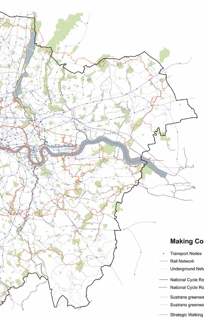
52 s pg TH E all lon don g r e e n g r i d Improve sustainable travel connections 4.20 National Cycle Networks, the London Cycle Network, including London Greenways and the Strategic Walk Network support and promote sustainable transport choices, leisure options and physical activity (see Figure 6). These strategic networks link and pass through the green infrastructure network. They should be attractive, well signed, sheltered, safe and well maintained. Better understanding of the existing strategic network of cycle and walking routes and transport nodes will enable improvements to be made to strategic links between routes, transport hubs and places of landscape, cultural and heritage interest Projects should improve the quality of walking (via initiatives such as Legible London) and cycling routes (via initiatives such as the Barclays Cycle Hire scheme and Cycle Super Highways), extend them, enhance their connectivity and link green spaces together. Local routes, important in their own right, should link in with this strategic network and opportunities to create and improve routes to encourage green travel choices should be identified and incorporated into projects. The Biking Borough initiative and local Sustrans projects are also delivering improvements London Plan policies set the spatial framework to support this function of green infrastructure, especially through policies on encouraging cycling that seek to increase the proportion of journeys made by cycle, and walking (Policies 6.9 and 6.10). Improvements to the public realm and green infrastructure, making them both safer and more attractive with enhanced way finding, legibility and accessibility, will also support this aim (policies 7.3 and 7.5) This objective is also carried through into the policies and proposals in the Mayor s Transport Strategy (Policy No 17, Proposals No 54 and 60) and initiatives such as the 2012 Games Walking and Cycling routes, the Great Outdoors and Better Streets. The Outer London boroughs rights of way improvement plans also have a key role in delivering sustainable travel connections.
53 53 Promote healthy living 4.23 Improving access to, and the enjoyment of the green space network promotes healthy living (see Figure 7). The provision, protection and improvement of sports facilities, including playing fields, as well as encouraging the use of parks, play facilities and other green spaces, are central to encouraging more active lifestyles and improved mental wellbeing. Green spaces are also known to contribute to the psychological and social wellbeing of communities, having a positive effect on stress levels, mental health and community cohesion. High quality, well managed open spaces that provide safe environments can discourage crime and antisocial behaviour. This reduces the fear of crime and makes available the benefits of public open spaces to more of the local community The London Plan sets the spatial framework for supporting this function and delivering benefits from enabling healthy active lives. Encouraging Londoners to be more active is covered under the previous section (cycling, walking and enhanced public realm) The protection and provision of sports facilities (Policy 3.19) and children s play facilities (Policy 3.6) are encouraged. Revised SPG on providing for children s and young people s play and informal recreation is currently on public consultation and the final SPG will be published in The provision of social infrastructure, including play, recreation, sport and other facilities is recognised as crucial to making an area more than a place to live in (Policy 3.16). Access for all sections of the community (Policy 7.2) needs to be provided to create safe accessible places that encourage social cohesion (Policy 3.2).Boroughs can identify spaces of relative tranquillity that have been shown to benefit mental health as part of their open space strategies (Policy 7.15). There are also health and community benefits from encouraging the use of land for growing food near to the communities it serves (Policy 7.22). Policy 7.1 of the Plan also recognises the need for neighbourhoods to be designed to enable people to live healthy and active lives with access to green infrastructure and the Blue Ribbon Network. Issues around design for personal safety are addressed in Policy 7.3. Supplementary guidance on Lifetime Neighbourhoods will be published for public consultation in late It will give guidance on how these issues can be integrated into developments The Mayor s Sport Legacy Plan supports healthy living by aiming to increase participation in sports activities and the Mayor s Health Inequality Strategy policies and proposals also support the healthy living aspects of the ALGG. Other partners such as the NHS have a major part to play in achieving this objective with voluntary organisations such as Groundwork, British Trust for Conservation Volunteers with the Green Gym initiative and Sustrans making major contributions.

54 s pg TH E all lon don g r e e n g r i d Figure 6: Making connections Transport Nodes Rail Network Underground Network National Cycle Route National Cycle Route proposed Sustrans greenways Sustrans greenways proposed Strategic Walking Routes Other Walking Routes Thematic Local Walks Public Open Space Map derived from GiGL data 2011 Crown Copyright and database right All rights reserved London Development Agency 2011
55 55
56 s pg TH E all lon don g r e e n g r i d Figure 7: Healthy communities Children and Teenagers Play Spaces Playing Fields Recreation Grounds School Grounds Hospital Grounds Golf Course Equestrian Other Recreation Map derived from GiGL data 2011 Crown Copyright and database right All rights reserved London Development Agency 2011
57 57
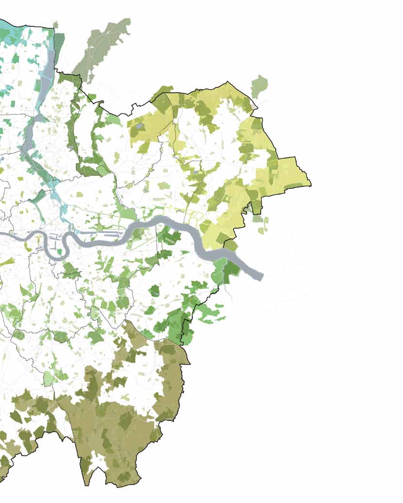
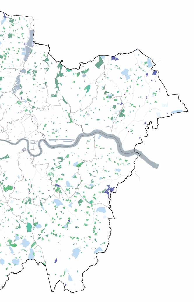
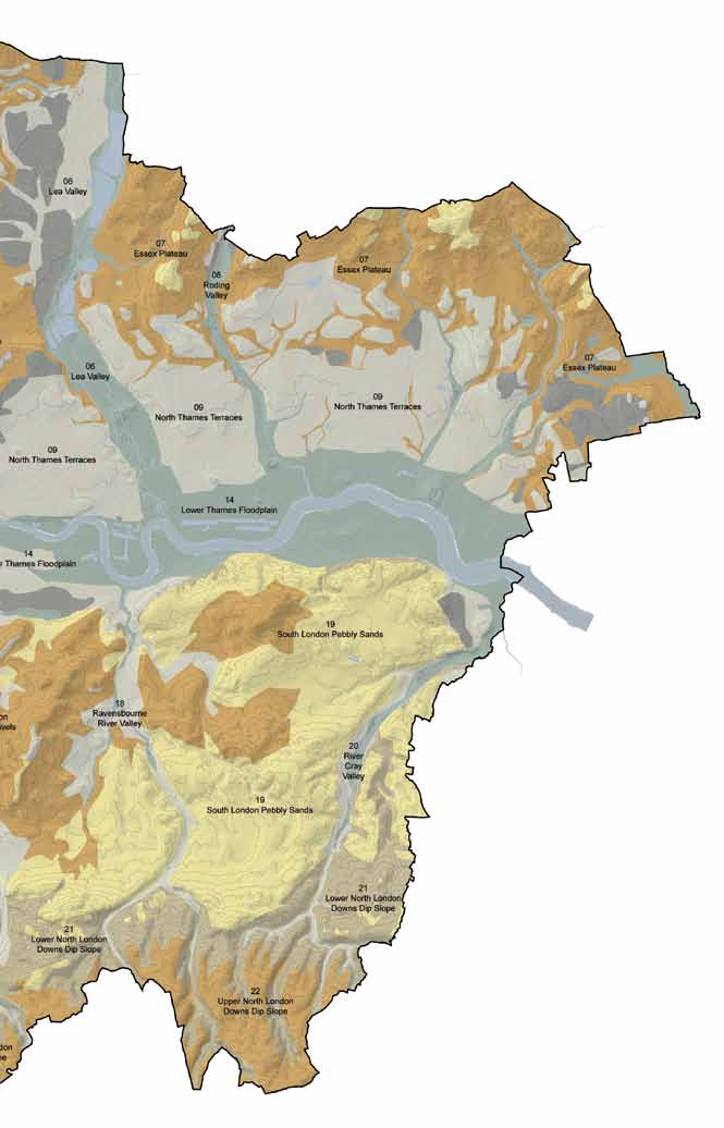
58 s pg TH E all lon don g r e e n g r i d Conserve and enhance heritage features, geodiversity and landscape character 4.27 London contains a wide variety of open spaces and cultural landscapes that are historically significant and that have significant heritage and cultural value. These assets can provide social, economic, cultural and environmental benefits. It is crucial that a holistic approach can be taken towards the management of green spaces that incorporate an understanding of their intrinsic heritage values. Understanding the origins and history of the semi-natural and designed landscapes can provide information on how these areas could be managed, conserved and protected Landscapes and heritage assets play a role in creating the basis for individual and collective cultural identity. Their positive contribution to local character and sense of place should be understood and valued. Conservation of heritage assets should be appropriate and proportionate to their significance. English Heritage advises that heritage assets should be regarded as a nonrenewable resource and any changes proposed should be assessed for their potential harm to these assets. Any changes need to be considered as an integral part of place shaping. English Heritage has published guidance Understanding Place: Historic Area Assessments, Principles and Practice (2010) focussing on historic significance and character to assist in addressing these issues The ecological and landscape zones of London illustrate the traditional character of each area and can contribute to understanding the green infrastructure network (see Figure 8). The natural and historic heritage of London should be carefully integrated into landscape proposals to enhance an area s distinctiveness and the sense of place for neighbourhoods. The zones can be used as the context for the landscape character of the area and to guide the restoration, creation and maintenance of wildlife habitat, informing the wider strategy of initiatives at the landscape scale and the development of projects. Some areas are of particular significance as they are landscapes that are contiguous with natural features in London s hinterland. The Thames Estuary Marshes to the east, the Downlands to the south and the ancient woodlands to the north provide opportunities for landscape scale restoration and management and recreational opportunities of a significant scale. They are also the landscapes which form part of broader initiatives, such as Thames Estuary Parklands, which straddle the London boundary Natural England has published London s Natural Signatures a framework for London that identifies 22 natural landscape character zones, which are illustrated in Figure 8. Each character type is described and specific landscape features are identified to produce a natural signature that provides a snapshot of the unique and recognisable natural characteristics of each zone. The key influences that shape the landscape are set out and design clues are highlighted to inform future development. The relevant natural signatures are included in each of the Green Grid Area descriptions in Chapter 5 of the SPG.
59 The landscape character zones numbered in Figure 8 are listed below: 1) Colne Valley 2) Ruislip Plateau 3) Barnet Plateau 4) Finchley Ridge 5) Hampstead Ridge 6) Lea Valley 7) Essex Plateau 8) Roding River Valley 9) North Thames Terraces 10) Hayes Gravels 11) Brent River Valley 12) Hounslow Gravels 13) Upper Thames 14) Lower Thames Floodplain 15) South Thames Heaths & Commons 16) Wandle River Valley 17) South London Clays & Gravels 18) Ravensbourne River Valley 19) South London Pebbly Sands 20) River Cray Valley 21) Lower North Downs Dip Slope 22) Upper North Downs Dip Slope There are both regionally and locally important geological sites (RIGS and LIGS). These should be protected and enhanced by development proposals (see London Plan Policy 7.20). Boroughs should use the advice set out in the Mayor s supplementary guidance on London s Foundations and the expertise of the London Geodiversity Partnership to investigate sites to determine if additional sites should be protected via the planning system. RIGS are identified in the London Plan on Map The panoramas, river prospects and townscape views that are protected and managed through the London Plan (see policies 7.11 and 7.12) are often seen from open spaces such as parks. Open spaces also afford more local views and panoramas; these provide opportunities to inspire people to re-connect with their local environment and can be interpreted to promote regeneration An understanding of the underlying geodiversity, the historic value and the character, design and quality of both the natural and designed landscapes is required to fully understand and respect the context of the network of green infrastructure. London Plan policies on local character (Policy 7.4) identifying heritage assets (Policy 7.8), heritageled regeneration (Policy 7.9, World Heritage Sites (Policy 7.10) and geological conservation (Policy 7.20), provide the spatial framework to achieving this function of the ALGG. SPG is being developed to assist in establishing the elements of local context to be considered in relation to Lifetime Neighbourhoods, including the integration of green infrastructure. This guidance (on Shaping Neighbourhoods) will be published for public consultation late in Other partners, especially the boroughs working with English Heritage and Natural England can also provide a wide range of guidance, expertise and sometimes funding.
60 s pg TH E all lon don g r e e n g r i d Figure 8: Ecological and landscape zones Chalk soils Gravel and Sandy hilltops Clays Loams Low level Gravels Flood Plain soils Annotated Natural Signatures Natural England Crown Copyright and database right All rights reserved London Development Agency 2011
61 61
62 s pg TH E all lon don g r e e n g r i d Enhance distinctive destinations and boost the visitor economy 4.35 There is a wide range of visitor attractions and places of interest across London that are associated with open spaces in London, including cultural buildings, historic parks and gardens, visitor centres, museums, water activities, country parks, nature reserves, view points and golf courses (see Figure 9) This network forms a key element of the strategic cultural areas identified in the London Plan (Policy 4.5). For example, the parks and spaces in central London contribute to the world class status of the capital as a visitor destination and the green spaces and extensive parklands of Greenwich Riverside in East London and London s Arcadia in South West London complement the visitor experience to some of London s most historic sites. The London Plan also provides support for promoting existing and new cultural and visitor attractions in outer London where they can contribute to regeneration and town centre renewal (Policy 4.6) Where relevant, projects should improve and promote natural and historic heritage value, visitor facilities, interpretation, views into and out of green spaces, green routes and linkages as part of widening the appeal and use of the green infrastructure network. The spatial distribution of facilities and places of interest can be used to help inform the development of projects to improve the coverage and availability of these resources. London Plan policies on local character, public realm and views (policies 7.4, 7.5, 7.11 and 7.12) outlined above support this benefit. Other partners such as the Thames Landscape Strategy, English Heritage, London Partners, the Lee Valley Regional Park Authority and the Olympic Legacy Park Company can also contribute. The Mayor s Cultural Strategy sets out policies and proposals that give further support The Olympic venues in east London will form a major new international visitor destination for sport, recreation and tourism. The Queen Elizabeth Olympic Park will form a key element in this new visitor offer and the image of this part of London over the longer term (Policy 2.4).

63 63 Figure 9: Distinctive destinations World Heritage Site Listed Building / Scheduled Monument Registered Parks and Gardens Museum Gallery Theatre / Performance Venue Library / Archive Cemetery or Churchyard Formal Garden Other Public Open Space Map derived from GiGL data 2011 Crown Copyright and database right All rights reserved London Development Agency 2011
64 s pg TH E all lon don g r e e n g r i d Promote sustainable design, management and maintenance 4.39 The design, management and maintenance of green infrastructure need to be of a high standard in order to meet the ALGG vision. Green infrastructure that plugs in to the existing green space network needs to be planned and designed as an integrated part of all new development proposals and regeneration programmes and the resources for management and maintenance identified and secured Understanding the context of green space within the urban environment is an essential prerequisite to ensuring a more sustainable approach to design, management and maintenance. An approach recognising that existing green spaces can provide a wide range of benefits over and above their recreation functions and aesthetic values ensures that management plans and investment strategies fully address the future requirements of the space as part of a network of green infrastructure assets (Policies 2.18 and 7.1) For example, incorporating Sustainable Drainage Systems (SUDS) can reduce surface water runoff in a more natural way as well as providing amenity value and benefits for wildlife. There are a number of SUDS design approaches that can be applied to suit the circumstances of the location including: rainwater harvesting; swales; soakaways; green roofs; gravel and grass; permeable and porous pavements; and basins, ponds and reed beds that can store water. Incorporating green roofs into the design and delivery of projects and proposals can have a wide range of benefits including: Helping to manage surface water; Reducing the Urban Heat Island effect; Enhancing biodiversity; Providing insulation; Reducing pollution; and Helping to protect and prolong the life of the roof Managing green infrastructure to provide a source of sustainable wood production can also bring economic and environmental benefits. The Forestry Commission has undertaken research and feasibility work on wood fuel using arboricultural arisings. It is currently working on developing a supply chain for the use of waste wood as a renewable energy resource There are a number of London Plan policies that give strategic support to promoting sustainable design and management benefits from the ALGG. These include an approach to sustainable design and construction (Policy 5.3) from the start of the design process of a scheme. This approach is elaborated on in Policy 5.9 which sets out a cooling hierarchy to avoid overheating and the impacts of the urban heat island. This is supported by policies 5.10 and 5.11 which set out the benefits of incorporating urban greening in developments, particularly in the CAZ. Policy 5.13 sets out a drainage hierarchy that will help the design of drainage for a development achieve a range of objectives, including for biodiversity and amenity. Policies on local character and the public realm address issues of landscape to support achievement of this benefit. It is always important, however, that consideration is given to the potential for adverse impacts on archaeology or historic significance or character. The Mayor s London Climate Change strategy provides more detail on the approaches to overheating and cooling
65 65 and to drainage. The SPG to the London Plan on Sustainable Design and Construction will provide more guidance on implementation through the development process Other partners that can assist implementation include the Forestry Commission with its right place, right tree initiative supported through the Mayor s London Tree and Woodland Framework (Policy 7.21) and the research on a supply chain for the use of waste wood (Policy 5.7). The London Parks and Green Spaces Forum is working with friends groups to spread good practice. Groundwork also has a number of projects through the INTERREG C-Change project, particularly in the Wandle Valley, that support this objective. The Environment Agency supports good practice in sustainable drainage, and the London Biodiversity Partnership can provide good advice on invasive species control via the London Invasive Species Initiative.

66 s pg TH E all lon don g r e e n g r i d Enhance green space and green infrastructure sector skills 4.45 There is a wide variety of occupations that are directly or indirectly associated with the planning, design and management of parks and other open spaces as illustrated in Figure 10. Those working in the green infrastructure sector in London will play an important role in delivering, managing and maintaining a high quality green space network. The jobs and skills in these sectors are needed to ensure that London can adapt to the effects of climate change Skills that will enable carbon emission reductions and support climate change adaptation within the green infrastructure sector should be an integral part of the implementation of the ALGG. The aim is to support the capability of the sector through the transition to the low carbon economy, by providing coordination, access to expert advice, training and knowledge transfer. For example, green roofs and walls provide thermal insulation that can save approximately 1.6 kilograms of CO 2 per square metre and can reduce the energy requirements of air conditioning by 75% The London Plan provides strategic policy support through policies 4.10 (new and emerging sectors) and 4.12 (opportunities for all). Government policy on localism, neighbourhood plans and volunteering could all provide opportunities for boroughs local schools and communities to consider how new green skills could be gained and brought, to bear on the maintenance and enhancement of ALGG. Initiatives such as BTCV s green gyms, Trees for Cities and the Mayor s volunteering strategy with the Re-Leaf programme all provide initial examples of good practice. Figure 10: Green space sector job Source: CABE (2009). Skills to grow: seven priorities to improve green space skills.
67 67 Promote sustainable food production 4.48 Land for food growing promotes active lifestyles, better diets and food security. In urban areas community food growing projects can be the focus for building increased social cohesion. Many projects engage some of London s most hard to reach individuals and evidence suggests they are very successful in building the confidence and skills of individuals and providing them with a path way to employment. Productive land in London includes food growing in allotments, community gardens in residential estates and agricultural farms on the urban fringe (see Figure 11). The maintenance of these and similar green spaces can be a way of bringing together diverse members of the local community and help to make new social links The protection of the Green Belt and Metropolitan Open Land ensures land is maintained for local food production or is available for food production in the future. The Mayor will seek to encourage and support thriving farming and land-based sectors in London, particularly in the Green Belt (see Policy 7.22). In more densely developed parts of the city green roofs and walls can provide opportunities for new local food growing (policies 7.16, 7.17 and 5.11). Other partners who can assist in achieving this benefit include the Mayor s Food Board and voluntary organisations such as Sustain and Thames Chase Community Forest Trust. Other productive uses for this land include food for animals and the production of biomass fuel for energy consumption Currently, only 30,000 Londoners use allotments to grow their own vegetables and fruit. The data demonstrate the lack of provision in parts of central London, compared to the outer boroughs. Combining these data with areas of demand at the local level can help to formulate where priorities should be focused in order to meet needs. Capital Growth, the local food growing initiative supported by the Mayor aims to transform the capital with 2,012 new food growing spaces by These spaces will complement the statutory allotment sites and introduce new spaces where these do not exist, particularly in central London that is excluded from legislation governing allotments (Policy 7.22). Over 35,000 Londoners are involved in community food growing projects as a part of the London-wide Capital Growth scheme (

68 s pg TH E all lon don g r e e n g r i d Figure 11: Productive Landscape Allotments / Community Gardens Horticulture / Orchards Arable Agriculture Livestock Agriculture Broadleaf Woodland Mixed Woodland Capital Growth Sites Map derived from GiGL data Crown Copyright and database right Ordnance Survey
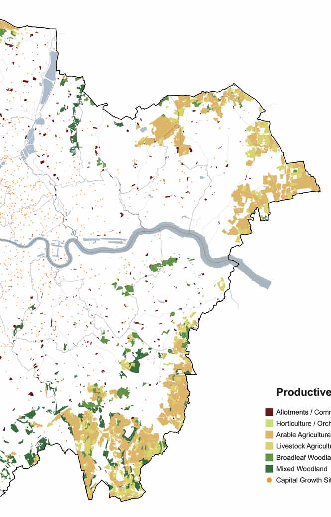
69 69
70 s pg TH E all lon don g r e e n g r i d Improve air quality and soundscapes 4.51 Green infrastructure, trees and vegetation are recognised as being able to filter pollution so improving the quality of the air in and around the green infrastructure network. Creating new green spaces and linkages and the urban greening of streets and buildings will assist in further reducing air pollution and improving the health and enjoyment of those visiting, living in and working in London Green spaces can provide havens of tranquillity and soundscape interest in a busy city: however, many green spaces can be blighted by noise. The design and management of the landscape and vegetation can help to reduce unwanted noise intrusion and support positive soundscapes, such as bird song or the noise of running water. Areas of relative tranquillity within the urban environment should be recognised and intrusive noise reduced. Policy 7.15 ( reducing noise and enhancing soundscapes) provides support for Boroughs to identify areas of relative tranquillity through their open space strategies The Mayor s Air Quality Strategy (together with London Plan Policy 7.14) recognise the importance of tackling air pollution and improving air quality. This is also supported by the Mayor s Transport Strategy (Policy 15 and Proposals 91 and 94). The promotion of walking and cycling (see above) can also help tackle the problem of poor air quality. TfL published sub-regional Transport Plans in 2010 which include steps to help address issues of air quality and noise. These are currently being updated. Improve the quality of and access to the urban fringe 4.54 The Green Belt around London has enormous potential to provide access to good quality countryside on the doorstep of London. There are many examples of good quality and enhanced countryside in the urban fringe that attract people, including Epping Forest, the Lee Valley Regional Park, the Colne Valley Regional Park, Thames Chase Community Forest and a range of country parks. Appropriate uses that are consistent with maintaining the open character of the land designated as Green Belt or Metropolitan Open Land can achieve positive improvements to the quality of the landscape and the accessibility of this resource. There are considerable opportunities to increase the amount of public access to the countryside around London and generally to link fragmented areas of public open space, by both public transport and walking and cycling routes (policies 6.9 and 6.10). Metropolitan Open Land is particularly important in inner London, and similar opportunities for improving its quality and access should be explored as contributors to the green infrastructure network linking through to London s countryside The London Plan supports the implementation of the Green Arc Vision which aims to create and protect an extensive and valued recreational landscape of well connected and accessible countryside around London for both people and for wildlife (Policy 2.18). Implementation of the ALGG projects will contribute to achieving this. Agriculture is an appropriate use in the Green Belt and farmers adopting agri-environmental stewardship schemes can deliver good environmental practice, including enhanced biodiversity benefits and improved access (Policy 7.22).
 can also support improving access to the urban fringe by providing the opportunities to identify and implement vital links in green infrastructure.")
71 London Plan policy on protecting local open spaces and addressing deficiencies (see Policy 7.18) can also support improving access to the urban fringe by providing the opportunities to identify and implement vital links in green infrastructure. Other partners such as the London boroughs, neighbouring county and district councils, the Environment Agency, Forestry Commission and Natural England through the Green Arc initiatives have a key role in implementing this. Voluntary sector organisations such as the Woodland Trust, Thames Chase Community Forest Trust and local wildlife trusts will also be key partners. Figure 12: Green belt and urban fringe Green Belt Designation Map derived from GiGL data Crown Copyright and database right Ordnance Survey

72 s pg TH E all lon don g r e e n g r i d Conserve and enhance the Thames riverside spaces 4.57 The riverside open spaces and the access to and along the River Thames enhance the experience and setting of London s iconic river, contributing to its historic, cultural and natural significance. Large and small parks like Bushy Park, Battersea Park, Jubilee Gardens and Potters Fields enhance the space of the river and provide destinations and view points that add to the sense of place. The Wildspace Park at Rainham provides a major new visitor destination centred on the Thames marshes in the east of London. The character of the riverside spaces changes along the Thames, meandering through meadows, historic parks and gardens in the west, through the more urban central area with its embankment promenades and parks, through to the industrial and docklands areas and the riverside marshes in the east. London s riverside spaces are often particularly rich in archaeology and they need to be managed appropriately London s four World Heritage Sites (WHSs), the Tower of London, Royal Botanic Gardens Kew, Maritime Greenwich and the Palace of Westminster and Westminster Abbey are all on the Thames and the open spaces at these locations are integral to the historical character and setting (Policy 7.10). The London Plan SPGs on the London View Management Framework and on the settings of WHS will provide support for partnerships to incorporate this aspect into WHS Management Plans Three strategies have been developed by partnerships that cover the Thames from Hampton to Kew (the Thames Landscape Strategy), Kew to Chelsea and the Thames estuary east of Tower Bridge. These strategies provide more detailed information and action points that should be taken into consideration when informing policy and developing projects 4.58 The Thames Path National Trail and towpaths provide routes and connections along the riverside, stimulating access and recreation. There are also a number of routes to the Thames through the open space network, such as through the Brent River Walk, the South East London Green Chain and from Richmond Park. There is considerable scope to improve this network and link into the Thames Path National Trail, for example where tributaries meet the Thames (policies 7.24, and 7.29). These other elements of the Blue Ribbon Network can also form a key part of the ALGG. For example where waterways can be restored and enhanced they can make a significant contribution to achieving many of the functions of the ALGG, such as adapting to climate change and enhancing biodiversity (Policy 7.27). Major infrastructure schemes such as the Thames Tideway Tunnel may also present opportunities to enhance and improve riverside areas affected.

73 73 for implementing the ALGG, as does TE2100 (see Glossary). The partnerships that have developed these strategies will be significant to implementing these projects in the ALGG. The Environment Agency, Port of London Authority, Natural England and the relevant Boroughs will be key to achieving this. A partnership led by the Environment Agency has produced a River Restoration Action Plan for London to assist in the restoration of waterways by naturalising river channels. The Agency also has the lead in producing River Basin Management Plans. Some of these projects will be implemented through capital projects and some through nearby developments. Voluntary groups such as Thames 21 and the London Wildlife Trust also have a significant role. The Thames Discovery Programme through the Thames Estuary Partnership has a significant role in areas of archaeological importance. Figure 13: Thames riverside spaces links and attractions Routes to the river World Heritage Site Landscapes related to the Thames Museum Gallery Theatre / Performance Venue Library / Archive Map derived from GiGL data Crown Copyright and database right Ordnance Survey
, Downe,")
74 s pg TH E all lon don g r e e n g r i d Down House (Home of Charles Darwin), Downe, Kent
75 75 CHAPTE R five g r e e n g r i d ar eas

76 s pg TH E all lon don g r e e n g r i d 5.1 The eleven Green Grid Areas (GGAs) provide the basic framework from which policies and projects can be developed and delivered. The ALGG Areas update, complement and expand upon the six areas established as part of the ELGG to provide a pan London framework. This is illustrated in Figure 14. The parts that are shaded in more than one colour indicate where the areas overlap. Figure 14: Green Grid Areas 1 Lea Valley and Finchley Ridge 8 2 Epping Forest and River Roding 3 Thames Chase Beam and Ingrebourne 10 5 Bexley, River Cray and Southern Marshes 11 6 South East London Green Chain Plus 12 7 London s Downlands Wandle Valley Arcadian Thames River Colne and Crane Brent Valley and Barnet Plateau Central London Map derived from GiGL data Crown Copyright and database right Ordnance Survey
77 The Green Grid Areas numbered in Figure 14 are listed below. The list highlights how they have developed from the ELGG work. 1) Lee Valley and Finchley Ridge Extended existing ELGG area 2) River Roding and Epping Forest Extended existing ELGG area 3) Thames Chase, Beam, Ingrebourne Extended existing ELGG area 4) Previous ELGG area 4 is now absorbed in Areas 2 and 3 5) River Cray and Southern Marshes Extended existing ELGG area 6) South East London Green Chain Plus Extended existing ELGG area 7) London s Downlands New area 8) Wandle Valley New area 9) Arcadian Thames New area 10) River Colne and Crane New area 11) Brent Valley and Barnet Plateau New area 12) Central London New area 5.3 This section briefly describes each of the Green Grid Areas, illustrating the strategic components of the open space network. It highlights and suggests enhancements to the existing open space network of landscape corridors, the east west links in between and the urban areas it serves. It also identifies the key open space opportunities that should be used to inform the development and delivery of the network and the implementation of the Green Grid. This information will inform development planning, master planning, borough open space strategies, the design and delivery of new landscapes, open spaces, and links and their subsequent management. The key opportunities have been developed from a range of plans and strategies, including borough local development documents and open space strategies, and through partnership workshops, with the London boroughs, national agencies such as the Environment Agency and Natural England and other open space and landscape planning, design and management organisations. 5.4 The relevant landscape Natural Signatures, or character zones, identified in Figure 8 are included in each of the Green Grid Area descriptions that follow in this section of the SPG. This landscape scale information should be used as a starting point to identify the local context for the development of projects, proposals and management plans within each of the Green Grid Areas. More detailed information on the landscape character zones can be found at london/ourwork/londonnaturalsignatures.aspx
78 s pg TH E all lon don g r e e n g r i d GGA1 Lee Valley and Finchley Ridge 5.5 The Lee Valley and Finchley Ridge includes parts of the boroughs of Barnet, Enfield, Hackney, Haringey, Newham, Islington, Tower Hamlets and Waltham Forest. The area includes four of the landscape character zones identified by Natural England, as shown in Figure 8. The Natural Signatures of each of the relevant landscape zones are set out in Table 5.1. Table 5.1: Landscape Natural Signatures Landscape zone 4. Finchley Ridge 5. Hampstead Ridge 6. Lea River Valley 9. North Thames Terrace Natural Signature Ridgetop blocks of ancient woodland on former commonland A mosaic of ancient woodland, scrub and acid grassland along ridgetop summits with panoramic views Braided tributary streams flowing across wide open marshes to join the River Lea and its sequence of reservoirs Flat, open grassland, stepping up from the Thames, with narrow sinuous strips of woodland marking the alignment of tributary creeks 5.6 The Mayor has produced an Opportunity Area Planning Framework for the Lower Lea Valley that provides strategic planning guidance to establish the Green Grid as part of new development proposals. He has also produced a draft Olympic Legacy SPG, which has been out to consultation, and which will supersede the Lower Lea Valley OAPF. The Upper Lee Valley Landscape Strategy (Feb 2010) was carried out for the Lee Valley from Lea Bridge Road to the M25 to provide a detailed landscape character analysis. 5.7 The 37km long Lee Valley Regional Park was formed in 1966 and extends from Tower Hamlets and Newham to Ware in Hertfordshire. Within the M25, the park provides a green corridor with a number of large reservoirs through north London. North of Hackney Wick the open space, reservoirs and waterways form a largely continuous open landscape that continues into Essex. Hackney Marsh, in the southern part of the GGA, is a flat open space with mainly amenity grass fringed with trees that provides a large number of playing fields that are regionally important for football. From Hackney Marsh to the River Thames the River Lee splits into a number of separate channels which are all canalised and diverge at Bow Locks and are largely inaccessible to the south of Bow Creek. The open space in this southern section is more fragmented and restricted by the surrounding urban development. 5.8 Large accessible parks in the Green Belt to the west of the Lee Valley are connected by a number of strategic and local links. Trent Country Park provides 400ha of meadows,

79 79 Figure 15: Lee Valley and Finchley Ridge Green Grid Strategic Corridors Strategic Links Metropolitan Park Opportunities Regional Park Opportunities Regional Parks Metropolitan Parks District Parks Local Parks and Open Spaces Small Open Spaces Pocket Parks Other / Private Open Spaces Strategic Walking Routes Strategic Cycling Routes Map derived from GiGL data Crown Copyright and database right Ordnance Survey
80 s pg TH E all lon don g r e e n g r i d woodlands and lakes. Many of these spaces, like Forty Hall, are associated with former country house estates. These parks are linked together by the London LOOP through to the Lee Valley Regional Park. There are a number of small tributaries of the Lee in the western part of the area, some of which are accessible and provide green corridor links. 5.9 The Isle of Dogs Link forms a short route from the River Thames through the docklands area to the Mudchute and Millwall Park green area, joining with the River Thames again at Island Gardens The Victoria Park/Mile End Park Link forms a continuous green space corridor from Limehouse Basin adjacent to the River Thames, to the Lee Navigation canal and the Lee Valley Regional Park. Linear canals are a dominant feature of this open space link The Elevated Greenway Link functions as a Greenway; segregated shared access route with pedestrian priority built on top of the Northern Outfall Sewer. It is currently the only east-west link north of the river in East London. The route is suitable both as a destination route linking with two major employment areas, and as a leisure route. At present beyond the recently refurbished section within the Olympic Park boundary the remaining sections of the Greenway to the River Roding where it meets the Thames are in need of refurbishment The London Olympic Link will join the new parkland and local green infrastructure created as part of the Olympic Legacy, through the built area to the open landscape of Epping Forest at Wanstead. The route is mainly urban in character, with West Ham Cemetery providing a green space in-between The Highams Park Link comprises a small tributary passing through residential areas of Highams Park. There is no formalised right of way along its length The Clissold Park Link forms part of the Capital Ring strategic path, linking the park, nature reserve, open space, the monuments and chapel of Abney Park and through streets to the Lee Valley The Finsbury Park Link connects the park with the complex of green space at Downhills Park and Lordship Recreation Ground through to Bruce Castle Park and Tottenham Cemetery. The Link then connects with the Tottenham Marshes in the Lee Valley Regional Park. The linkages between these green spaces run through largely residential areas The Parkland Walk Link runs along a disused railway line connecting Finsbury Park to Highgate Wood and Queen s Wood and then onto Alexandra Park The Wood Green Link connects Clissold Park in the south to Finsbury Park and Alexandra Park to the north, continuing on through Wood Green to Palmers Green. Outside of these green spaces the link mainly passes through built-up areas The Pymmes Brook Link follows a small tributary from Pickett s Lock on the River Lee out to Monken Hadley Common in the Green Belt. The Pymmes Brook Trail links with the London LOOP in the north and the Lee Valley Walk in the south, passing through a number of parks, including Oak Hill, Brunswick, Arnos and Pymmes. The trail follows the waterway along most of its course but goes through the urban area in several areas, including crossing the A10.
81 The Salmon Brook Link starts in the Green Belt, running through farmland before passing through residential areas and golf courses. It then connects to Bury Lodge Park and onward through cemeteries and playing fields in Edmonton to the green spaces of the Lee Valley Park at Pickett s Lock. In this last section the Brook is only visible in these pockets of green space The Enfield Link follows the New River course through Bush Hill Park golf course and the Town Park, connecting with the town centre. The route follows the river as it loops around the town and playing fields. The Link then moves north through largely residential areas and connects with the Green Belt at Myddelton House and Gardens and Capel Manor College The Turkey Brook Link follows the London LOOP from the Lee Valley Walk at the Prince of Wales Open Space via Albany Park and through built areas connecting to Forty Hall Country Park, Hillyfields Park and Whitewebbs Park in the Green Belt The Hampstead Heath Ridge Link connects the Heath to Alexandra Park in the north via Highgate Wood and in part follows the northern arm of the Parkland Walk through Muswell Hill. Parts of the route pass through residential areas and alongside a golf course The Whitewebbs Link forms a route through the Green Belt from Hillyfields Park on the urban fringe through Whitewebbs Country Park and beyond Strategic green infrastructure opportunities: 1) Deliver a new 100ha park for London as part of the legacy of the 2012 Olympics; a park which will act as the focal point for new and existing communities, and help to improve eastwest connectivity across the Lea Valley linking with the improved access developed through the ODA funded 2012 Games Walking and Cycling Routes programme. 2) Complete the strategic north-south connection through the Lea Valley to the Thames via the creation of the Fatwalk and a series of new open spaces as part of the future Lea River Park. 3) Open Walthamstow Wetlands (ten Thames water owned reservoirs to the north of the Olympic Park) to wider public access as a regionally significant urban nature reserve and wetland centre, including new and improved entry points, nature trails and a cycle route linking the Lee Valley Path and Olympic Park; visitor centre, housing an exhibition, interpretation, educational resource and café. The project will reconnect the reservoirs with surrounding urban areas and open spaces of Lee Valley Regional Park, creating a metropolitan scale landscape. 4) Strengthen the connections between a series of open spaces between Finsbury Park and the Lee Valley, extending the Parkland Walk Link and creating a sustainable transport route which in part follows the course of the Moselle River. 5) Provide new areas of accessible open space and better routes into and across the Lea Valley at Meridian Water to support and shape anticipated regeneration and the creation of an exemplary sustainable neighbourhood.
82 s pg TH E all lon don g r e e n g r i d 6) Strengthen the landscape connection of the Pymmes Brook Link from Monken Hadley Common to the Lea Valley along the course of the Pymmes Brook providing a chain of interlinked and diverse open spaces, and enhancing the ecology of the watercourse. 7) Maximise the potential of the Green Belt, by improving facilities and attractions at Trent Country Park and Forty Hall Park, and enhancing north-south landscape connections across the M25 and into the wider extent of the Green Belt. 8) Transform Ponders End into a key gateway into the Lea Valley creating improved views and connections into and across the valley, and new leisure uses to attract visitors. 9) Develop the New River as a key northsouth landscape connection, a sustainable transport route and a significant heritage asset. 10) Maximise the potential of Salmons Brook as a north-west to south-east landscape connection from the Green Belt in Barnet to the Lea Valley. 11) Improve the facilities of, and connections between, Alexandra Park, Highgate Wood, and Queens Wood along the Parkland Walk Link, in order to maximise their potential as a visitor destination of rich landscape character offering fantastic views across London. 12) Enhance the landscape connection of the Upper Lee Valley northwards beyond the M25 into Hertfordshire, and eastwards to the green space network and communities of Epping Forest and beyond.
83 83 GGA2 Epping Forest and Roding Valley 5.25 Epping Forest and Roding Valley includes parts of the boroughs of Barking and Dagenham, Newham, Redbridge and Waltham Forest. The area includes four of the landscape character zones identified by Natural England, as shown in Figure 8. The Natural Signatures of each of the relevant landscape zones are set out in Table 5.2. Table 5.2: Landscape Natural Signatures Landscape zone 7. Essex Plateau Natural Signature Mosaics of ancient woodland, wood pasture and acid grassland within the former royal hunting forests at Epping Forest and Havering 8. roding River Valley 9. North Thames Terraces The narrow, sinuous course of the upper Roding where the riverbanks are lined with willows Flat, open grassland, stepping up from the Thames, with narrow sinuous strips of woodland marking the alignment of tributary creeks 14. Lower Thames Floodplain A vast, flat riverside zone of grazed saltmarshes grading to reedswamp, mudflats and the wide tidal Thames the most striking and immediately visible natural element in London 5.26 The green corridors of Epping Forest and the Roding Valley weave their way from the Green Belt in the north, southwards towards the Thames. The open corridors are joined together by the Wanstead Flats and Wanstead Park. Epping Forest has a natural character and is mainly wood pasture, with areas of ancient woodland, heath, rough grass and scattered ponds. The Forest has pockets of quietness and generally has a peaceful character. Centenary Walk is well established and runs the length of the Forest from Manor Park in the south to the north of London To the south of Woodford the Roding Valley is dominated by road and utilities infrastructure and contains areas of both degraded open space and sites of surprising ecological value. Amenity grassland is the dominant land cover and there is relatively little tree cover. The Roding has largely been straightened and in many places is no more than a concrete channel. However, the tidal section of the river at Barking Creek supports extensive areas of mudflat and intertidal reedbed. The River Roding forms a confluence with the River Thames at Barking Creek. The area surrounding it is characterised by extensive sites of previously

84 s pg TH E all lon don g r e e n g r i d Figure 16: Epping Forest and Roding Valley Green Grid Strategic Corridors Strategic Links Metropolitan Park Opportunities Regional Park Opportunities Regional Parks Metropolitan Parks District Parks Local Parks and Open Spaces Small Open Spaces Pocket Parks Other / Private Open Spaces Strategic Walking Routes Strategic Cycling Routes Map derived from GiGL data Crown Copyright and database right Ordnance Survey
85 The open land cover in the southern part of the Green Grid Area is mainly amenity grass and rough grass with lakes providing the main features of interest with many rivers flowing through parks being lost into culvert. To the south of the A13 (T) the area is dominated by industrial areas on the River Thames floodplain and the open spaces are fragmented with access to the Roding being more limited The Essex Plateau Link follows the London LOOP through the open landscape of the Green Belt, linking the Lee Valley Regional Park in the west to Epping Forest and across the Roding Valley to Hainault Forest Country Park in the east The Highams Park Link comprises a small tributary passing through residential areas of Highams Park. There is no formalised right of way along its length The Redbridge Link comprises of Valentine Park, Claybury Park, Fairlop Waters and Hainault Forest Country Park through to LB Havering. Between these open spaces the route would pass along quiet roads, which should have opportunities to become Green Routes with avenues and cycle lanes The London Olympic Link will join the new parkland and local green infrastructure created as part of the Olympic Legacy, through the built area to the open landscape of Epping Forest at Wanstead. The route is mainly urban in character, with West Ham Cemetery providing a green space in between The Fairlop Link runs through residential areas and links Barking town centre in the Roding Valley to the open landscape at Fairlop Plain. Along the route the link runs through Barking Park and South Park to the complex of green spaces around Seven Kings Park. From here the link follows the route of the Seven Kings Water into Fairlop Plain The Elevated Greenway Link functions as a Greenway (a segregated shared access route with pedestrian priority) built on top of the Northern Outfall Sewer. It is currently the only east-west link north of the river in East London. The route is suitable both as a destination route linking with two major employment areas, and as a leisure route. At present beyond the recently refurbished section within the Olympic Park boundary the remaining sections of the Greenway to the River Roding where it meets the River Thames are in need of refurbishment The Mayesbrook and Goodmayes Link runs through the network of Goodmayes and Mayesbrook Parks and associated playing fields and cemetery to improve the green network in this area. The link then runs south following the Mayes Brook, which is inaccessible as it goes through the urban area, until its confluence with the River Roding. There is an opportunity to extend the significant improvements in ecological quality and usability as part of a range of flood storage and park enhancements The Parsloes Park Link connects the London Riverside Link in the south through the urban area to Castle Green and then Parsloes Park. It then continues northwards through suburban areas, connecting with Valence Park and St. Chad s Park in Chadwell Heath, where it then joins with the Green Belt The Beckton Park Link comprises Beckton District Park, Newham City Farm and New Beckton Park. Currently there is no clear connection between Beckton District Park and the Greenway on the Northern Outfall Sewer, and no clear link between New Beckton Park and the Thames riverside. The existing character of this area is predominantly naturalistic parkland with native tree and scrub planting.
86 s pg TH E all lon don g r e e n g r i d 5.38 The Goresbrook Link follows the Goresbrook River from Parsloes Park in Barking and Dagenham, through Goresbrook Park, the industrial and commercial development between the A13 and the railway line, and along the eastern boundary of the Barking Reach development site before reaching the River Thames. There are only two sections of this link where there is public access to the River: Goresbrook Park and the southern end of the link adjacent to the River Thames and Horse Shoe Corner The London Riverside Link includes the Barking Riverside development site and the Dagenham Dock Sustainable Industries Park. The redevelopment of the area will provide a new green space network through the district. A number of ditches and small water courses run through the area which provides an important habitat for water voles, birds and vegetation Strategic green infrastructure opportunities: 1) Create a Metropolitan Park linking the River Roding from Ilford to Barking Creek and the Beckton Park Link, consolidating a series of fragmented open spaces, improving access to maximise pedestrian and cycle connectivity and restoring the River Roding and its tributaries, incorporating flood storage, alleviating urban run-off and enhancing biodiversity. 2) Improve the ecological connections and routes between Mayesbrook Park and Goodmayes Park and the Recreation Ground (deculverting the brook where possible) in order to address the Metropolitan Park deficiency. 3) Improve the water quality and ecological value of the Goresbrook, removing culverted sections to create and enhance access along the Goresbrook Link from Parsloes Park through Goresbrook Park. 4) Create a linked network of high quality accessible open spaces with a strong wetland character, along the London Riverside Link between the Thames and Dagenham Dock. 5) Improve access, diversify use and improve the quality of the existing open space networks of Barking Town Centre and Urban Newham. Promote Abbey Green as the catalyst to create links south through the Gascoigne Estate to Barking Riverside and Beckton District Park to link north to Green Street, Plashet Park and Wanstead Flats. 6) Improve links from urban communities to Epping Forest, the Lea Valley and beyond to Essex, including creating routes that connect Wanstead Flats to the Centenary Walk through Walthamstow and Highams Park. 7) Integrate green infrastructure as part of the regeneration of Barking Riverside with particular emphasis on incorporating flood management/suds, conserving and enhancing biodiversity and creating a network of accessible green spaces. 8) Create a green infrastructure network in Fairlop Plain that focuses on improving the quality of the existing open spaces and river habitat, developing improved physical links between them. 9) Improve public space connections to the Royal Docks through the Arc of Opportunity between Canning Town, Thameside West and Beckton East and north towards Urban Newham connecting to the Greenway. 10) Enhance access to the River Thames and the docks through high quality public spaces and mixed use of the waterscapes.
87 87 11) Improve and link the lost rivers in the Ching, Seven Kings, Mayes, Gores and Loxford corridors, north to the Essex countryside and south to the Thames, enhancing public access, promoting creating and preserving riverine habitat and flood protection. 12) Preserve and enhance natural habitats around Barking Creek to establish wetland habitats such as grazing marsh, reed beds, ponds and wet woodland, increasing accessibility with potential for productive uses within Newham, whilst maintaining the navigability of the lower Roding for commercial and leisure use. 13) Enhance access and connectivity across major east-west infrastructure corridors, including the A13, River Roding, the Royal Docks and railway lines. 17) Adopt measures to address multiple ownership and deteriorating design integrity of the At Risk Grade II* Listed Park and Garden of Special Historic Importance stretching across Wanstead Park and western Wanstead Flats, linking Epping Forest to the Roding Valley corridor. 18) Maintain and enhance the environmental, ecological and flood management capacity of the designed water bodies at Wanstead Flats and Wanstead Park. 19) Maintain the safety, integrity and flood capacity of four Epping Forest Large Raised Reservoirs at Wanstead Park and Highams Park. 14) Improve east-west connectivity between key open spaces through creation of treelined streets and cycle routes linking the large network of parks (providing new sections of the National Cycling Network Route 13), improving access via new and existing bridges over rivers, and links to key destinations and development sites. 15) Create a link between the Wanstead Park (Epping Forest), Roding Valley, Claybury Park, Fairlop Waters, Hainault Forest Country Park and Havering along the Redbridge Link improving the quality of open space and restoring the culverted rivers. 16) Create and promote exemplar community led food growing sites across the area making use of underutilised land such as the derelict garages of Barking and Dagenham, Central Park nursery, or the walled garden of Ray Park, and enhancing existing sites such as Newham City Farm.
88 s pg TH E all lon don g r e e n g r i d GGA3 Thames Chase, Beam and Ingrebourne 5.41 The Thames Chase, Beam and Ingrebourne includes parts of the boroughs of Barking and Dagenham, Redbridge and Havering. The area includes three of the landscape character zones identified by Natural England, as shown in Figure 8. The Natural Signatures of each of the relevant landscape zones are set out in Table 5.3. Table 5.3: Landscape Natural Signatures Landscape zone 7. Essex Plateau Natural Signature Mosaics of ancient woodland, wood pasture and acid grassland within the former royal hunting forests at Epping Forest and Havering 9. North Thames Terraces Flat, open grassland, stepping up from the Thames, with narrow sinuous strips of woodland marking the alignment of tributary creeks 14. Lower Thames Floodplain A vast, flat riverside zone of grazed saltmarshes grading to reedswamp, mudflats and the wide tidal Thames the most striking and immediately visible natural element in London 5.42 The land north of the A118 is mainly flat arable land, with large open fields that maintains its rural and natural character. In the south gravel extraction has left its mark on the landscape, where this activity has led to former workings being used for landfill and also for recreation with land being restored as country parks at Fairlop Waters, Eastbrookend and Hornchurch. To the north and east of the GGA the land rises and is largely agricultural in character with wooded areas on higher ground. The Thames Chase Community Forest covers a very substantial of the rural area of the GGA Moving to the south the GGA becomes increasingly urbanized and industrialized. The Beam River valley is predominantly flat, open flood plain with sparse tree cover, although there are pockets of woodland and scattered trees in the parks. Lack of access to the watercourses which are also degraded, straightened, over deepened and reinforced with poor water quality is a key issue. The Rom and Beam Corridor connects Romford town centre with the Thames at Dagenham. Although the middle section of this corridor includes extensive areas of public open space, there is limited access in the town centres and where it meets the Thames.

89 89 Figure 17: Thames Chase, Beam and Ingrebourne Green Grid Strategic Corridors Strategic Links Metropolitan Park Opportunities Regional Park Opportunities Regional Parks Metropolitan Parks District Parks Local Parks and Open Spaces Small Open Spaces Pocket Parks Other / Private Open Spaces Strategic Walking Routes Strategic Cycling Routes Map derived from GiGL data Crown Copyright and database right Ordnance Survey
90 s pg TH E all lon don g r e e n g r i d 5.44 The Ingrebourne Valley is a gently sloping landscape at the eastern edge of Hornchurch and Romford with a predominantly rural/urban fringe character. Access along the edge of the Ingrebourne River is good, with the London LOOP long distance footpath running almost along its full course. North of Upminster, the Ingrebourne has steeper valley sides and land use consists mainly of pasture and arable fields. The land is relatively unspoilt, unlike the lower river valley which has been affected by gravel extraction and landfill, but also contains the ecologically rich Ingrebourne Marshes, a designated SSSI The Rainham, Wennington and Aveley Marshes (which are designated SSSI s) in the south of the GGA are flat grazing marshes and relatively dry reedbeds, intersected by a network of ditches and provide an important wildlife habitat. The River Thames is the main feature, affording views along and across the waterway, in a landscape that can have an open and exposed feel. The London Wildspace Park on these marshes will include the restoration of Rainham landfill site. The park is of regional importance and is being created by a number of partners including the Royal Society for the Protection of Birds. Some of the barriers that limit access to the park have been overcome The Dogg Kennel Hill Link follows the London LOOP through the Green Belt, connecting Hainault Forest Country Park in the east with Havering Country Park and Bedfords Park, through to Dagenham Park and the Ingrebourne Valley in the east The Romford Link follows the River Rom from Eastbrookend Country Park in the south to Romford town centre where the river becomes culverted. As it goes north the Link branches into two routes. The west route continues to follow the River Rom, though it is partly channelised and inaccessible behind residential development, before emerging into the Green Belt and connecting to the London LOOP. The east branch follows Blacks Brook which runs through a mainly green corridor that connects to Bedford Park in the north The Ravensbourne River Link follows the Ravensbourne River which is in poor condition and lacks any green corridor for most of its length through the residential area north of Hornchurch, past Hornchurch Sport Centre and through Harrow Lodge Park. There is currently no public access to the river where it runs through the residential area The London Riverside Link includes the Barking Reach development site and the Dagenham Dock Sustainable Industries Park and Rainham Creek. The redevelopment of the area will provide a new green space network through the district. A number of ditches and small water courses run through the area which provides an important habitat for water voles, wetland birds and estuarine vegetation The Berwick Link runs through the Green Belt from Hornchurch Country Park in the Ingrebourne Valley to accessible countryside in the Thames Chase Community Forest Strategic green infrastructure opportunities: 1) Improve the access to and the landscape quality of Fairlop Plain as part of the Redbridge Link and open up the Seven Kings Water to add to the diversity of the landscape. 2) Improve and protect the landscape value of the Ingrebourne valley including Rainham Creek, providing for informal recreation, reinforcing woodland planting in the north, and conserving and re-creating marshland and river habitats to the south. 3) Create an accessible open space network through the Dagenham corridor, linking Hainault
91 91 and Fairlop with the Thames, providing long distance paths and strengthening east-west connections. 4) Improve north to south links along the river corridors of the Gores, Wantz, Ravensbourne, Mardyke and Beam by upgrading access and transforming parks within the corridors with an added aim of improving the physical form and quality of these rivers. 5) Improve and strengthen east/west links through the area by increasing access and connectivity along major east/west infrastructure corridors such as the A13, A1306 and railway lines and by creating new cycle corridors and tree lined streets. 10) Open up the culverted sections of the Goresbrook restoring naturalised river banks and floodplains, providing access along the Goresbrook Link from Parsloes Park through Goresbrook Park and the Barking Riverside development site to the Thames. 11) Improve the London LOOP long distance footpath linking Harold Hill in the north and the Thames and integrating other foot and cycle routes and destination points within the GGA. 12) Improve Harrow Lodge Park and restore the lake and river (Ravensbourne), to enhance the landscape features, softening the hard engineering of the river and lake and improving amenity value of the Park. 6) Provide a new public park, civic square and tree lined streets within Romford Town Centre, enhancing pedestrian and cycle routes to surrounding green spaces and restore and enhance access to the River Rom through opening up of culverts, naturalising river channels and enhancing the recreational potential of the river. 7) Create a mosaic of open spaces and woodland in Thames Chase and improved access to the open countryside. Restore a number of completed landfill and mineral extraction sites in this area as new open spaces to increase public access. 8) Create the London Wildspace Park as an exemplar sustainable regional park for the 21st century, restoring and enhancing biodiversity and floodplains and providing informal opportunities for recreation in the countryside alongside the River Thames. 9) Create a linked network of accessible open spaces with a strong wetland character, along the London Riverside Link and at Rainham Creek.
92 s pg TH E all lon don g r e e n g r i d GGA5 River Cray and Southern Marshes 5.52 The River Cray and Southern Marshes include parts of the boroughs of Bexley and Bromley. The area includes four of the landscape character zones identified by Natural England, as shown in Figure 8. The Natural Signatures of each of the relevant landscape zones are set out in Table 5.4. Table 5.4: Landscape Natural Signatures Landscape zone 14. Lower Thames Floodplain 19. South London Pebbly Sands 20. River Cray Valley 21. Lower North Downs Dip Slope Natural Signature A vast, flat riverside zone of grazed saltmarshes grading to reedswamp, mudflats and the wide tidal Thames the most striking and immediately visible natural element in London Historic heathy commons and extensive woodland on elevated land with views over the Thames Basin from ridgetops and summits Chalk river with a natural profile which flows through a sequence of floodplain meadows and wet woodlands A diverse landscape with a transition from heath, scrub and woodland on the lower slopes to more open farmland and scattered ancient woodland on the rising chalklands to the south 5.53 The Crayford and Dartford Marshes are divided by the River Darent, which is characterised by embankments on either side. The fresh water grazing marshes are drained by a network of ditches and grazed by cattle. The marshes are very open and exposed and can feel quite desolate. An ongoing problem of neglect and fly tipping adds to the sense of insecurity. Nevertheless, the marshes mirror those on the north bank at Rainham and comprise one of the most ecologically significant areas in Greater London Between the A206 and A2 at Crayford, the River Cray corridor is dominated by industrial and commercial development. Between the A2 and A20 the valley becomes steep-sided and is characterised by extensive woodland, grazed water meadow, horse paddock, and arable fields The Green Chain corridor starts at the Thames in the borough of Bexley at Erith Riverside, it then goes through Franks Park and Lesnes Abbey before passing into Bostall Woods then via a network of open spaces in Greenwich and Lewisham on its way to Crystal Palace in the borough of Bromley. The London LOOP path follows the River Cray and provides good pedestrian access through the area. However, a number of roads and railway lines cross the area and form significant barriers.

93 93 Figure 18: River Cray and Southern Marshes Green Grid Strategic Corridors Strategic Links Metropolitan Park Opportunities Regional Park Opportunities Regional Parks Metropolitan Parks District Parks Local Parks and Open Spaces Small Open Spaces Pocket Parks Other / Private Open Spaces Strategic Walking Routes Strategic Cycling Routes Map derived from GiGL data Crown Copyright and database right Ordnance Survey
94 s pg TH E all lon don g r e e n g r i d 5.56 To the east of the River Cray in the southern part of the area, the Green Belt includes the chalk slopes of the North Downs which contain ancient woodland connected by hedgerows and surrounded by open farmland. The open spaces provide a mosaic of ancient woodland, acid heathland, hedgerows and wet grassland The Thamesmead Link connects the Thames riverfront and the Green Chain and includes Erith Marshes, Lesnes Abbey Woods and Southmere Park. The lower part of the link is characterised by canals, lakes and wetland habitats. A green route connects Lesnes Abbey Wood with Southmere Park, and the path continues along the Thamesmead canal system and through the housing estate to the river adjacent to the Victorian Pumping Station. The route crosses up and over the Ridgeway the path that sits atop the Southern Outfall Sewer which runs to the Crossness works on the west side of Erith Marshes. Thamesmead has areas of high-density residential housing and a challenging mix of issues requiring management The Ridgeway Link is an elevated path established above a major Victorian sewer. It forms a green link between the Thames Path at Crossness Sewage Treatment Works, to Plumstead. It is a key gateway from the west into the rich network of green open spaces and waterways in Thamesmead and Erith Marshes The River Shuttle Link runs from Avery Hill Park within the South East London Green Chain to Hall Place. It links a number of open spaces of various types including small local parks, school playing fields, a golf course, a number of narrow linear spaces between back gardens, woodland and allotment gardens. The Shuttle Riverway footpath follows most of the river course and links the open spaces together Strategic green infrastructure opportunities: 1) Conserve and improve the environmental and ecological value of Erith, Crayford and Dartford marshes, improving public access, pedestrian and cycle links. 2) Conserve and enhance the rural character and intimate scale of the landscape between the A2 and A20, exploring opportunities to increase the flood storage capacity of the local floodplain. 3) Maximise the potential of the River Cray corridor to create a high quality, accessible riverside environment, including strengthening connections of green spaces between the A206 and A2 and links to surrounding green spaces and countryside on the urban fringe, including the Chalk Link to the North Downs. 4) Strengthen and enhance the landscape connections along the Thamesmead Link from Lesnes Abbey Wood to the Thames riverfront including Erith Marshes. 5) Enhance the river character and recreational use of the River Shuttle Link and strengthen the connections between its open spaces, improving public access. 6) Examine the feasibility of developing the South East London Green Chain as a regional park opportunity. 7) Promote and enhance the long distance South East London Green Chain footpath and links by improving accessibility into and through the area, particularly access from its edges.
95 95 GGA6 South East London Green Chain Plus 5.61 The South East London Green Chain Plus includes parts of the boroughs of Bexley, Bromley, Croydon, Greenwich, Lewisham and Southwark. The area includes four of the landscape character zones identified by Natural England, as shown in Figure 8. The Natural Signatures of each of the relevant landscape zones are set out in Table 5.5. Table 5.5: Landscape Natural Signatures Landscape zone 14. Lower Thames Floodplain 17. South London Clays & Gravels 18. ravensbourne River Valley 19. South London Pebbly Sands Natural Signature A vast, flat riverside zone of grazed saltmarshes grading to reedswamp, mudflats and the wide tidal Thames the most striking and immediately visible natural element in London Small hedged meadows and large heathy commons set against a backdrop of extensive woodlands on higher land A network of small rivers, bounded by gravel terraces, which flow through water meadows and tidal flood meadows before reaching the Thames as a navigable channel, bordered by working wharves Historic heathy commons and extensive woodland on elevated land with views over the Thames Basin from ridgetops and summits 5.62 The South East London Green Chain, a long established partnership between the London boroughs of Bexley, Bromley, Greenwich, Lewisham and Southwark, is an extensive and reasonably well connected network of parks and open spaces which are linked via the Green Chain Walk. The character of the Green Chain is very varied and includes ancient and semi-natural woodland, historic parkland, heath, horse paddocks, playing fields, cemeteries, and allotment gardens. Most of the open spaces have an urban character, with mown grass and views to surrounding suburban housing. Some spaces, however, retain a rural character, such as the horse paddocks around Eltham Palace. Dulwich and Sydenham Hill Woods are the closest ancient woodland to central London The commons and woodlands on the Southern Ridge provide long views and strong spatial relationships with the River Thames, as well as the meandering Pool, Quaggy, Ravensbourne and Shuttle rivers. These tributaries with their associated wetlands, parks and green corridors allow connections with the local and the wider landscape by providing waymarked routes. The eastern marshlands stretch from the bottom of the ridge towards Thamesmead giving the River Thames a breadth and wild quality not present further upstream.

96 s pg TH E all lon don g r e e n g r i d Figure 19: South East London Green Chain Plus Green Grid Strategic Corridors Strategic Links Metropolitan Park Opportunities Regional Park Opportunities Regional Parks Metropolitan Parks District Parks Local Parks and Open Spaces Small Open Spaces Pocket Parks Other / Private Open Spaces Strategic Walking Routes Strategic Cycling Routes Map derived from GiGL data Crown Copyright and database right Ordnance Survey
97 The Ravensbourne and Pool Rivers (the Waterlink Way) consist of narrow open space links with a strong urban character that are tightly developed on both sides of the water courses. Most of the open spaces in this western part of the GGA are amenity spaces and contain sports pitches or linear parks of mediocre quality. The railway line running south from Lewisham runs along the Ravensbourne and crosses the river several times, restricting access to the adjacent open spaces The Ridgeway Link is an elevated path established above a major Victorian sewer. It forms a green link between Crossness Sewage Treatment Works, Thamesmead and Plumstead; and is a key gateway from the West into the rich network of green open spaces and waterways in Thamesmead and Erith Marshes The Greenwich to Eltham Link runs from Greenwich Park and Blackheath to Eltham Palace through a number of sports and recreation grounds and Sutcliffe Park. Currently there is no designated footpath linking these spaces The Kidbrook Link provides a short link between the Greenwich to Eltham Link and the Green Chain. The spaces within this link generally have a low quality vegetation structure. The Kidbrook has been culverted along most of its course through the residential area of Kidbrook and there is no public access along the edge of the brook The Thames Barrier to Shooters Hill Link is a well connected and high quality open space network which has a rich and diverse character including mature woodland, common and parkland The Woolwich Common Link connects the Thames and Woolwich town centre through the Common to the Thames Barrier to Shooters Hill Link The Winn s Common Link heads north from the Green Chain through the urban area, connecting with Shrewsbury Park and Plumstead Common to the Thames at the Woolwich Arsenal The Tripcock Point Link connects the Thames with the Green Chain at Plumstead Common. The part of the link through Thamesmead is characterised by footpaths along lakes and canals in the former low-lying marshland The Thamesmead Link forms part of the South East London Green Chain and includes Erith Marshes, Lesnes Abbey Woods and Southmere Park The Quaggy River Link area is mainly urban in character and waterways have been straightened and canalised, with the exception of certain sections, such as through Sutcliffe Park, where the river channel has been restored. The Link forms a connecting route between the Beck, Green Chain and Heath Walk link The South Norwood Link connects South Norwood Country Park to the green spaces at New Beckenham to the north east and Park Hill in East Croydon to the south west. The route travels through mainly residential streets with only small pockets of green space in either direction The Central London Link connects a number of important open spaces going north from Crystal Palace Park, including One Tree Hill, Sydenham Wells Park, a number of golf courses, the Horniman Gardens, the Camberwell cemeteries, Peckham Rye Common and Park and on towards Burgess Park in central London. The spaces are not connected by a continuous green corridor and the links in between are reliant on the streets through the urban environment.
98 s pg TH E all lon don g r e e n g r i d 5.77 Strategic green infrastructure opportunities: 1) Examine the feasibility of developing the South East London Green Chain as a regional park opportunity. 2) Promote and enhance the long distance South East London Green Chain footpath and links by improving accessibility into and through the area, particularly access from its edges. Develop extensions of the South East London Green Chain by creating new links, including Sutcliffe Park to Greenwich Park, Avery Hill to Hall Place, Plumstead to Tripcock Park, New Beckenham to Ladywell Fields, Beckenham Place Park to Bromley Town Centre, and Crystal Palace Park to South Norwood Country Park. 3) Create a connected park system along the Ravensbourne and Pool Rivers re-instating the natural channel, improving habitats, creating an exemplary green transport route including a link southwards towards Bromley, and exploring opportunities for improving health and the local environment. 8) Promote and enhance the existing woodland and heathland character of the Thames Barrier to Shooters Hill Link. 9) Strengthen and enhance the landscape connections along the Thamesmead Link from Lesnes Abbey Wood to the Thames riverfront including Erith Marshes. 10) Improve connections and the quality of open space in the Deptford, Deptford Creekside, New Cross/New Cross Gate area, creating new green links and routes along the alignment of the former Surrey Canal and improving the connections with the River Thames and parks in adjacent areas. 11) Promote and enhance connections between the open spaces north from Crystal Palace Park towards Burgess Park, including One Tree Hill, Sydenham Wells Park, Horniman Gardens, the Camberwell cemeteries, Peckham Rye Common and Park. 4) Reinstate a natural river course along the Quaggy River with natural banks and meanders, enhancing flood storage capacity and creating sustainable drainage schemes. 5) Reinstate, extend and improve the historic open spaces surrounding Eltham Palace and Charlton House. 6) Strengthen and enhance the connections along the Tripcock Point Link, promoting habitat types characteristic of this part of the tidal river environment. 7) Improve the relationship and connection with nature across the GGA, including the use of nature trails and a green link between Woolwich Common and the Thames.
99 99 GGA7 London s Downlands 5.78 The London s Downlands Area includes the boroughs of Bromley, Croydon and Sutton. The area includes six of the landscape character zones identified by Natural England, as shown in Figure 8. The Natural Signatures of each of the relevant landscape zones are set out in Table 5.6. Table 5.6: Landscape Natural Signatures Landscape zone 17. South London Clays & Gravels 18. ravensbourne River Valley 20. river Cray Valley 19. South London Pebbly Sands 21. Lower North Downs Dip Slope 22. Upper North Downs Dip Slope Natural Signature Small hedged meadows and large heathy commons set against a backdrop of extensive woodlands on higher land A network of small rivers, bounded by gravel terraces, which flow through water meadows and tidal flood meadows before reaching the Thames as a navigable channel, bordered by working wharves Chalk river with a natural profile which flows through a sequence of floodplain meadows and wet woodlands Historic heathy commons and extensive woodland on elevated land with views over the Thames Basin from ridgetops and summits A diverse landscape with a transition from heath, scrub and woodland on the lower slopes to more open farmland and scattered ancient woodland on the rising chalklands to the south Ancient woodland and chalk grassland on steep valley slopes emphasise the striking, sculpted chalkland relief 5.79 The land rises gently to the south of the area as the ridge of the North Downs stretch from the east to the west just to the south of London. The area contains many of the capital s woodlands, trees, and hedgerows and almost all of its chalk grasslands. There are many ponds and ancient rights of way and the area supports a rich tapestry of small mixed farming and arable fields. The landform changes through the suburbs as it is based on London clay where remnant and significant open spaces, parks, gardens and grounds form networks together and to the wider countryside. Down House, the home of Charles Darwin, forms an important historical and educational feature of the open landscape in the London Borough of Bromley and is proposed by the UK Government as a World Heritage Site.

100 s pg TH E all lon don g r e e n g r i d Figure 20: London Downlands Green Grid Strategic Corridors Strategic Links Metropolitan Park Opportunities Regional Park Opportunities Regional Parks Metropolitan Parks District Parks Local Parks and Open Spaces Small Open Spaces Pocket Parks Other / Private Open Spaces Strategic Walking Routes Strategic Cycling Routes Map derived from GiGL data Crown Copyright and database right Ordnance Survey
 and the Kent Downs AONB adjoin the Green Belt and overlap the edge of the Green Grid Area, which makes walking into open countryside")
101 There are extensive views across the valleys, downlands and some of the capital s widest views across central London to Greenwich, Wembley and Heathrow. The Surrey Hills Area of Outstanding Natural Beauty (AONB) and the Kent Downs AONB adjoin the Green Belt and overlap the edge of the Green Grid Area, which makes walking into open countryside feasible from many open spaces within London s Downlands. The Downlands Management project includes the open spaces in the south of the London Boroughs of Sutton and Croydon and extends across north east Surrey. Established in 1988, the project aims to improve the quality of the countryside in the urban fringe Large accessible open spaces in the Green Belt create green corridors that extend into the urban area, such as Farthing Downs and Happy Valley towards Coulsdon Common. Crystal Palace Park serves 5 London boroughs and with investment could become a prominent south London visitor attraction in its own right. There are three London strategic walking routes which run east-west across the area. The Green Chain Walk largely coincides with the Capital Ring which then continues west beyond Crystal Palace Park whilst The London LOOP is further south and links many of the most dramatic downlands parks and open spaces. This route goes up and down the ridges and valleys of the downlands. The Vanguard Way runs southwards from central Croydon to the downlands of the rural fringe. Parts of the urban fringe are living working landscapes, with a predominance of privately owned green space, such as golf courses, farmland, horticulture, hospitals, and an airport, which make this green edge less publicly accessible.
102 s pg TH E all lon don g r e e n g r i d 5.82 The Rivers Wandle, Beck, Ravensbourne and Cray form north/south corridors that extend from the urban area into the Green Belt. The Ravensbourne River Valley Corridor starts in the dry valley to the southwest of Biggin Hill and runs northwards to Caesar s Well at Keston Ponds where the river emerges. It continues northwards though Norman Park, Glassmill Reservoir and the canalised Queens Mead to the west of Bromley town centre before leaving the area through Beckenham Place Park heading further northwards to Deptford Creek. The Beck River Corridor starts to the south of West Wickham near New Addington, this corridor includes the River Beck as it emerges at Spring Park, running northwards through High Woods to Kelsey Park and the canalised Cator Park section towards the River Ravensbourne. The River Cray Corridor starts from the many dry chalk valleys in the extreme south east of London, the River Cray emerges in Priory Gardens, Orpington. Connecting many open spaces, including Riverside Gardens and Ruxley Lakes before entering Bexley The Chalk Walk corridor follows the chalk downlands through the southern parts of Bromley, Croydon and Sutton. From Pratts Bottom, through High Elms Country Park and Darwin s Landscape Laboratory to nature reserves at Saltbox, Hutchinson s Bank near New Addington and Selsdon and Kings Woods. It continues through Kenley Common to Farthing Downs and Happy Valley. It has links through to Oaks Park in Sutton and to Kent and Surrey The Chalk Link runs from the River Cray through the Green Belt, connecting with the Chalk Walk corridor to the south The Croydon Link connects the Wandle Valley via Croydon town centre where it becomes the Heath Walk Link to Hayes Common and beyond. The western section is largely built up in character, incorporating small public spaces such as Wandle Park and Park Hill. As it goes eastwards the link becomes greener in character as it passes through playing fields and golf courses. There are larger public open spaces in this section The Croham Hurst Link provides a short connection between Croham Hurst and Littleheath Woods and Bramley Bank The South Norwood Link connects South Norwood Country Park to the Green Chain spaces at New Beckenham to the northeast and Park Hill in East Croydon to the southwest. The route continues through mainly residential streets with only small pockets of green space in either direction The Downs Link connects the Roundshaw Estate to the open land in the Green Belt. It passes through mainly residential areas interspersed with golf courses Similarly, the Downs Walk Link runs to the south of the Roundshaw Estate to connect to the North Downs in the urban fringe The Sutton to Banstead Downs Link runs through the urban area from the town centre into the open land in the Green Belt and on into Surrey The Water Link Way connects the North Downs towards the conservation area at Kenley Aerodrome. It is part of the National Cycle Network Route 21. It connects a number of parks and green spaces from Selsdon to South Norwood while following the Pool and Ravensbourne Rivers. The route was designed to be very accessible, with a large number of railway stations on route towards Greenwich The Vanguard Way Link starts at East Croydon this link runs southwards through Lloyd Park and is a long distance walk to Newhaven on the coast.
103 The Heath Walk Link runs through Chislehurst Common and Scadbury Park, Petts Wood and Jubilee Country Park to Hayes and Keston Commons. It includes Spring Park and Threehalfpenny Wood towards Addington Hills, Croham Hurst, Littleheath Woods and Lloyd Park to Croydon town centre The Little Woodcote Link starts in the chalk downlands at Happy Valley and then passes through Coulsden and Crane Hill and through Oak Park to join the Sutton Banstead Downs Link Strategic green infrastructure opportunities: 1) Promote Darwin s Landscape projects on heritage, education, interpretation, biodiversity and access. 2) Develop a London s Downlands Countryside Park incorporating urban areas within the visual envelope and protected green views, improving green links to the Surrey Hills AONB and Kent Downs AONB, promoting community agriculture and woodland harvesting projects and branding Downlands role as a food producer for London within the M25. 3) Improve the ecological and environmental quality of the four river valleys through restoration projects, habitat enhancement and species re-introduction, and projects which seek to mitigate flood risk. 6) Increase biodiversity, create nature reserves and promote sustainability for appropriate visitor facilities, building on the High Elms Country Park Visitor Centre as an exemplar. 7) Promote traditional countryside management techniques such as grazing, coppicing and particularly in the urban/ rural edge and along river valleys to create green corridors through the urban area to the countryside. 8) Support the concept of the Great North Wood through conserving existing woodland fragments and identifying the potential for expansion and re-connectivity. 9) Promote shared use of private open spaces based on the Kenley Common model. 10) Improve Crystal Palace Park as a key anchor within the South East London Green Chain, a regional park opportunity. Crystal Palace Park represents a major opportunity for improvement by rejuvenation of the park through the development and implementation of a comprehensive masterplan that seeks to define improved relationships with its surroundings, linking the current Green Chain and green spaces in Southwark. 4) Increase access to nature and the countryside around New Addington. 5) Improve awareness of the public rights of way network and promote access to managed corridors that incorporate new strategic walking, cycling and riding routes linked to the Green Chain and London LOOP.

104 s pg TH E all lon don g r e e n g r i d GGA8 Wandle Valley 5.96 The Wandle Valley Area includes parts of the boroughs of Croydon, Lambeth, Merton, Sutton and Wandsworth. The area includes four of the landscape character zones identified by Natural England, as shown in Figure 8. The Natural Signatures of each of the relevant landscape zones are set out in Table 5.7. Table 5.7: Landscape Natural Signatures Landscape zone 15. South Thames Heaths & Commons 16. Wandle River Valley 17. South London Clays & Gravels 21. Lower North Downs Dip Slope Natural Signature Mosaic of heathland, grassland and ancient wood pastures with groups of veteran trees Water meadows echoing the meandering course of the river, backed by sinuous bands of wet woodland Small hedged meadows and large heathy commons set against a backdrop of extensive woodlands on higher land A diverse landscape with a transition from heath, scrub and woodland on the lower slopes to more open farmland and scattered ancient woodland on the rising chalklands to the south 5.97 Much of the river corridor lies to the rear of houses, behind industrial estates or bordering allotments and sports fields. The river has occasionally become hidden in the urban environment being culverted, contained, difficult to access and poorly connected to the neighbourhoods that surround it. Along some parts of its course the river has natural banks, amenity grasslands, wet woodlands, large commons and water meadows, all rich in biodiversity. The Wandle Trail, an established footpath and cycleway, follows the course of the river wherever access is possible The Wandle Valley is home to a significant amount of industrial and employment space. Historically water mills were located along the river, and the Valley continues to play an important strategic role in terms of London s industrial capacity. There are remnants of the rich architectural and industrial heritage that can be found along the valley, along with grander landscapes of country estates and other areas of open space used for outdoor sports and allotments.

105 105 Figure 21: Wandle Valley Green Grid Strategic Corridors Strategic Links Metropolitan Park Opportunities Regional Park Opportunities Regional Parks Metropolitan Parks District Parks Local Parks and Open Spaces Small Open Spaces Pocket Parks Other / Private Open Spaces Strategic Walking Routes Strategic Cycling Routes Map derived from GiGL data Crown Copyright and database right Ordnance Survey
106 s pg TH E all lon don g r e e n g r i d 5.99 The Wandle Valley Regional Park initiative sets out a vision for the creation and improvement of a linked network of open spaces along the river corridor. The park will connect to town centres, transport hubs, communities and business areas, extending out to connect to the open spaces in the surrounding area. This includes Mitcham Common, a large area of grassland and woodland, which added to the proposed new country park, would provide an extensive open space corridor to Beddington Park in the south. The protection and restoration of the river corridor s natural qualities will play an important role in making a vital and vibrant piece of green infrastructure in this part of London The Wimbledon Common Link runs via the Capital Ring strategic walk to the west connecting to the large open spaces of Wimbledon Park, Wimbledon Common and Richmond Park To the east of the Wandle the Graveney/Norbury Brook Link runs through residential areas. It is often canalised or inaccessible until it reaches Norbury Park, where it goes on to link with open spaces in Thornton Heath The Tramside Link follows the rail route and connects Croydon town centre, through Wandle Park and Mitcham Common to Poulter Park The Croydon Link connects the Wandle Valley via Croydon town centre to Hayes Common. The western section is largely built up in character, incorporating small public spaces such as Wandle Park and Park Hill. As it goes eastwards the link becomes greener in character as it passes through playing fields and golf courses. There are larger public open spaces in this section, including Lloyd Park, Addington Hills, Kennel Wood and Spring Park The Roundshaw-Wallington Link comprises the open spaces around the Roundshaw estate, Mellows Park and Bandon Hill cemetery. There is currently no clear connection with the Wandle River The Sutton Link connects to the open spaces at Carshalton through a largely residential area. It then connects Sutton town centre to Nonsuch Park in the west The Sutton to Banstead Downs Link runs through the urban area from the town centre into the open land in the Green Belt and on into Surrey The Morden Park Link extends to the west from the Wandle Valley and connects to Morden Park and to sports grounds and Beverley Brook beyond. Another branch of the Link runs from Watermeads through the St. Helier Open Space and residential areas to the southern edge of the park The Wandsworth Common Link heads east following the Capital ring strategic walk and passes through cemeteries and sports grounds within residential areas to Wandsworth Common. It then extends to Tooting Common and Streatham Common to link with Crystal Palace Park, again passing through largely residential areas The Mitcham Link connects Beddington Park going northwards through the new country park at Beddington Farmlands to Mitcham Common. It continues north, linking smaller green spaces including Streatham Park Cemetery, Figge s Marsh through the urban area to Tooting Common.
107 Strategic green infrastructure opportunities: 1) Continue work to create a new regional park as a vehicle to improve the quality, management, funding and identity of open space within the Wandle Valley. 2) Improve the ecological and environmental value of the River Wandle through restoration projects (such as deculverting the river in Wandle Park), habitat enhancement and species re-introduction, and projects which seek to mitigate flood risk. 7) Develop a mutually beneficial relationship between the open space network and industrial space within the Wandle Valley from facilitating access improvements through to nurturing a unique sense of place which can help to enliven and enrich the identity of the regional park. 8) Capitalise on the area s abundance of heritage assets including watermills, mill races, Merton Priory, and Merton Abbey Mills, to develop the regional park as a landscape rich in historical character. 3) Create a 200 hectare country park at Beddington Farmlands through the restoration of land used for gravel extraction and landfill tipping, linking Beddington Park with Mitcham Common. 4) Create a district park through the unification of Poulter Park, Revesby Wood, Middleton Open Space, St Helier Open Space, and Rose Hill Park. 5) Create improved cycle and pedestrian connections to the Wandle Valley and Wandle Trail from the surrounding areas through significant open spaces such as the proposed district park, and a suite of projects connecting the River Wandle to Croydon Town Centre. 6) Develop an exemplar sustainable neighbourhood at Hackbridge with low carbon development closely integrated with the River Wandle through improved cycle and pedestrian connections, and energy generation associated with river restoration projects.
108 s pg TH E all lon don g r e e n g r i d GGA9 Arcadian Thames The Arcadian Thames includes parts of the boroughs of Hounslow, Kingston, Merton, Richmond, Sutton and Wandsworth. The area includes three of the landscape character zones identified by Natural England, as shown in Figure 8. The Natural Signatures of each of the relevant landscape zones are set out in Table 5.8. Table 5.8: Landscape Natural Signatures Landscape zone 13. Upper Thames 15. South Thames Heaths & Commons 17. South London Clays & Gravels Natural Signature The meandering River Thames, together with the transitional mud-flats, shingle beaches, islands and flood meadows alongside Mosaic of heathland, grassland and ancient wood pastures with groups of veteran trees Small hedged meadows and large heathy commons set against a backdrop of extensive woodlands on higher land The character, scale and quality of the open spaces throughout this GGA are closely linked with the heritage, views and relationship with the River Thames. The River meanders through a landscape of historic and royal parks (already of the highest standard), heritage sites, a variety of wildlife habitats and residential and employment areas. Important views can be found from the parks and open space of the Thames and towards landmarks in central London In the centre, the large open spaces of Richmond Park through to Wimbledon Common and Putney Heath provide a rich mosaic of heath, common, ancient woodland and parkland and are key elements in the character of this area, forming important landmarks. To the south of the area pockets of amenity spaces, grassland and woodland lead from the built up area into the urban fringe countryside where a network of woodlands, hedgerows and small meadows can be found The Thames Path National Trail runs for 184 miles along the river s bank from its source in the Cotswolds to central London. It runs through the northern part of this area linking large, high quality open spaces from Hampton Court and Bushy Park to Kew and Barnes and links to the strategic corridors of the Hogsmill River, the Crane Valley, the Brent Valley and the Beverley Brook The Beverley Brook corridor connects the Thames Path National Trail through Barnes Common, Richmond Park, Wimbledon Common and a myriad of public open spaces to the south following the Beverley Brook itself. Many strategic links connect to the corridor including links from the Wandle Valley, Morden, Sutton and Raynes Park.

109 109 Figure 22: Arcadian Thames Green Grid Strategic Corridors Strategic Links Metropolitan Park Opportunities Regional Park Opportunities Regional Parks Metropolitan Parks District Parks Local Parks and Open Spaces Small Open Spaces Pocket Parks Other / Private Open Spaces Strategic Walking Routes Strategic Cycling Routes Map derived from GiGL data Crown Copyright and database right Ordnance Survey
110 s pg TH E all lon don g r e e n g r i d The Hogsmill River Corridor forms a strategic corridor from the Thames at Kingston following the Hogsmill River and subsequently the Bonesgate stream to the urban fringe and countryside at Malden Rushett. Many strategic links connect into the corridor using a series of open spaces along with national routes including the Thames Downs Path and London LOOP. The Brent River Valley corridor connects the Thames Path National Trail at Brentford along the Brent River and the Grand Union Canal to a network of historic and large open spaces including Boston Manor and Osterley Park. The strategic corridor of the Grand Union Canal links to the River Crane further to the west. The Crane River Valley corridor connects to the Thames Path National Trail to the south of Isleworth. It connects a series of parks, recreation grounds and open spaces associated to the river valley. Further west the corridor connects to Crane Park and Hounslow Heath The Ham Gate Link extends from the Teddington Lock footbridge (River Thames) and Ham Riverside Lands through residential streets and Richmond Park to connect with the Beverley Brook Corridor. Its northern branch connects to Ham House and the River Thames The Wimbledon Common Link connects Richmond Park to the Wandle Valley to the east via Wimbledon Common and Wimbledon Park, following the route of the Capital Ring strategic walk. The route continues eastwards to Crystal Palace Park as the Wandsworth Common Link The Morden Park Link extends east from the Beverley Brook corridor to the Wandle Valley via Morden Park The Sutton Link connects Nonsuch Park to Sutton town centre and onwards to the open spaces at Carshalton through a largely residential area The Tolworth Link heads southwest from the Hogsmill corridor connecting green spaces that are linked through residential streets into Surrey The Hampton Court Link extends from the Teddington Lock footbridge (River Thames) and green spaces on the Thames through Teddington to Bushy Park and Hampton Court Park, crossing the River Thames at Hampton Court Bridge The Kingston Ham Link connects from the Thames at Petersham to Richmond Park and runs through the Kingston residential area towards the town centre of Kingston The Putney Park Link runs from the Barnes Common through a large residential area west of Putney town centre towards Wimbledon Common The Sheen Gate link connects Richmond Park via Sheen Lane to the River Thames The Kew Link runs from the River Thames between the Royal Botanic Gardens and Old Deer Park golf course and is linked with North Sheen Station and onwards connected with East Sheen Common. It then follows the northern boundary of Richmond Park eastwards to connect with the Beverley Brook Corridor. There is an aspiration to link Kew across the River Thames to Syon Park The Isleworth Link connects Isleworth waterfront, possibly connecting with the Kew Link (see above), to the Crane River Valley and Twickenham Stadium along Twickenham Road. The southeastern branch passes through Craneford Playing Fields to terminate at the western end of Twickenham town centre and River Thames where there may be potential to investigate a new river crossing.
111 The Bushy Park Link connects the Thames towpath running alongside Hampton Court and Bushy Park to Kempton Park race course, Kempton Park Reservoirs and the urban area of Hampton The Sutton to Banstead Downs Link connects the Sutton Link and Sutton town centre with the Banstead Downs along Brighton Road and linking to Overton recreation ground The Thames Downs Link connects the residential centres of Erwell to the Thames Down footpath which links the River Thames and Thames Path National Trail at the centre of Kingston to the North Downs. The Thames Downs Link follows to course of the Hogsmill River before meeting the Thames Down Path at Tolworth Farm and continuing along the Hogsmill River corridor to Kingston The Wandle Park Link connects from the Beverley Brook corridor at Raynes Park to Putney town centre and Wandsworth Park. The connection mainly runs through residential areas and also connects Wimbledon town centre and Wimbledon Park Strategic green infrastructure opportunities: 1) Restore the lost floodplains of the River Thames and its tributaries in order to create new opportunities for biodiversity and flood risk management at Ham, Petersham Meadows, Hurst Park, Canbury Gardens, Marble Hill, Old Deer Park, Syon Park, Kew Gardens, Grove Park, Barnes Wetland Centre and open spaces along the Beverley Brook and Hogsmill River. 2) Promote recreational riverside improvements along the River Thames that enhances the experience, making it legible and accessible to pedestrians, and where appropriate cyclists, through resurfacing of the towpaths. 3) Develop the green network along the Hogsmill River Valley corridor to re-instate the natural channel where possible with improved habitats, amenity space and enhanced flood storage capacity and a new district park as a focal point for the surrounding residential areas and integrate links with surrounding farm land. 4) Develop the green network along the Beverley Brook River Valley corridor to create a parkland network linked to the Thames Path National Trail. Enhance the connection between Richmond Park and Wimbledon Common and create a series of linked open spaces and nature areas including Combee Wood, Beverley Park, Morden Park, Motspur Park and Pyl Brook. 5) Increase the potential for biodiversity and nature conservation in areas between Richmond Park, Wimbledon Common, the Thames corridor and the countryside, particularly along the Beverley Brook and Hogsmill rivers, creating green links and pedestrian connections to the smaller surrounding open spaces. 6) Create and enhance an interconnected network of footpaths, cycle routes and river crossings that link open space corridors creating linear connections and gateways to connect important riverside open spaces. 7) Integrate green infrastructure as part of the Twickenham Area Action Plan, the Brentford Waterway Town, the Kingston Ancient Market Place, Tolworth Broadway regeneration and the Morden town centre green link. 8) Enhance key heritage features and the landscape character of the Arcadian Thames such as at Richmond Park, the Old Deer Park and Kew Gardens and develop the area as a destination for tourism in order to improve the local economy.
112 s pg TH E all lon don g r e e n g r i d 9) Conserve the network of formal and informal views and panoramas that criss-cross the Arcadian Thames landscape. 10) Enhance and promote centres of sporting excellence throughout the Arcadian Thames utilising the existing public and private sports facilities along the Thames. 11) Promote productive landscapes, including sustainable food production and urban farms, incorporating historic agricultural field patterns as a transition from the urban area to the countryside in Green Belt. Improve allotments facilities to address the deficiency in provision, expanding the Knollmead permaculture site and creating a new site in the Thamesfield or East Putney wards.
113 113 GGA10 River Colne and Crane The River Colne and Crane includes parts of the boroughs of Ealing, Hillingdon, Hounslow, Harrow and Richmond. The area includes seven of the landscape character zones identified by Natural England, as shown in Figure 8. The Natural Signatures of each of the relevant landscape zones are set out in Table 5.9. Table 5.9: Landscape Natural Signatures Landscape zone 1. colne Valley 2. ruislip Plateau 3. Barnet Plateau 5. hampstead Ridge 10. hayes Gravels 11. Brent River Valley 12. hounslow Gravels Natural Signature Fast- flowing, clean rivers set within floodplain meadows bordered by damp woodland Field hedgerows dotted with oaks and bluebells beneath hornbeam coppice echoing the ancient trees of Ruislip Woods Long views from remnant heathy commons A mosaic of ancient woodland, scrub and acid grassland along ridgetop summits with panoramic views Small-scale, enclosed landscape of meadows bordered by tall hedgerows, with woodlands, copses and hedgerow trees Meandering, shallow river bordered by diverse floodplain meadows and winding strips of damp woodland A large scale mosaic of heathy grassland, scrub and secondary woodland, traversed by narrow, lush stream corridors Whilst the two river catchment landscapes within the GGA are linked as part of the notional West London Green Web, they both have dedicated governance arrangements in place and as such are sub-divided below.

114 s pg TH E all lon don g r e e n g r i d Figure 23: The Colne valley and Crane Valley Green Grid Strategic Corridors Strategic Links Metropolitan Park Opportunities Regional Park Opportunities Regional Parks Metropolitan Parks District Parks Local Parks and Open Spaces Small Open Spaces Pocket Parks Other / Private Open Spaces Strategic Walking Routes Strategic Cycling Routes Map derived from GiGL data Crown Copyright and database right Ordnance Survey
115 115 10a The Colne valley The Colne Valley Regional Park was established in 1965 and includes the open spaces on the western boundary of London, extending into the neighbouring authorities. It contains a mosaic of farmland, woodland, braided rivers, canals and lakes. A long history of gravel extraction is reflected in the filled land and open water landscape character along the Colne The River Colne is the main important strategic corridor, with a wide floodplain, extending into London from the Chilterns. The corridor of the River Pinn, a tributary of the Colne is also important. Much of the open land is in private ownership but there is a network of paths, such as the Colne Valley Trail, that link to large areas with public access, including Denham Country Park, Hillingdon House Farm and Harmondsworth Moor Extensive ancient woodland in the north of the area, known as Ruislip Woods, forms the landscape setting for the surrounding urban area. The north of the area is characterised by gently undulating slopes which flatten out south of the M40 and include historic parklands, woodland and heathland. Lakes created as a result of gravel extraction form a feature along the eastern edge of the valley. Paths create a link along the River Pinn that runs from West Ruislip to Pinner through residential areas, open meadows and amenity grassland. The southern part of the GGA is dominated by Heathrow Airport and there is a large scale impact on the environmental quality of the area The Duke of Northumberland s Link follows this river from the Crane River corridor into the Colne Valley as it passes through the urban area and to the south of Heathrow Airport. The river is largely inaccessible, and canalised within the urban area where there are only small pockets of green space The Harmondsworth Link connects the Colne and Crane strategic corridors through a complex network of green spaces, most of which do not have public access The Grand Union Canal Link connects to the Crane River and Hillingdon trail at Minet Country Park. The London LOOP walk follows the canal westwards through Hayes and Yiewsley and links to Stockley Country Park and the Colne Valley The Colne Valley Link runs through a mosaic of open spaces and built up areas, from Yiewsley in the south, where it joins the River Colne, northwards to the woodland and commons at Ruislip. The route passes through parks and playing fields along the route, including Hillingdon House Farm, but has to go through the built area where there is no public access to the river The Ruislip Link partly follows the River Pinn from Pinner through to Ruislip, passing through parks and private green spaces for much of the way. The Link continues west after Ruislip through residential areas before connecting to the Colne Valley The Park Wood Link runs from the Green Belt in the north to the significant woodlands and commons at Ruislip. It then passes through the urban area to connect to the Yeading Brook. Further connections also run to the west from this link back to the Colne Valley through the large parks in between.
116 s pg TH E all lon don g r e e n g r i d The Park Wood Ruislip Link starts at the green spaces of the Ruislip National Nature Reserve and heads south west through Mad Bess Wood and Bayhurst Wood Country Park. From here it follows roads through open countryside to join the London LOOP and Grand Union Canal Walk continuing through Denham Country Park The Bishop s Wood Country Park Link connects Rickmansworth, which is part of the Three River district council area and runs through Moor Park and Batchworth Park Golf Courses. The link continues to Bishop Wood Park and Northwood Hills The Ruislip Yeading Link runs from the Lynsters and Pynesfield Lake towards the village of Harefield with great views over the Colne Valley Park. The link continues east after this and runs through the residential area to Ickenham end in the Yeading Brook The Uxbridge Common Link heads east from the Common thorugh the urban area of North Hillingdon before joining the Hillingdon Trail. It then follows the Trail through green spaces, including woodland and golf courses, where it joins the Yeading Brook The Colne Northwood Link heads east from Park Wood in the Colne Valley following the London LOOP strategic walk through open countryside and connecting with Bishop s Wood Country Park. It then continues through the Northwood suburban area, still following the London LOOP, to Oxhey Woods. The route then continues eastwards in GGA10. 10b The Crane Valley The Crane Valley maintains a predominantly natural composition rising in the north of Harrow as the Yeading Brook and flowing through Hayes (becoming the Crane), passing to the east of Heathrow Airport and Hounslow Heath through Twickenham to Isleworth where it reaches the Thames The shallow valley of the River Crane provides the only variation in the topography across the flat landscape of the Hounslow Gravels. The area is characterised by recent industrial and interwar suburban development interspersed by corridors and patches of open space along tributary streams The Crane River valley contains accessible open spaces and paths along the river corridor from Twickenham to the large open space of Hounslow Heath. The London LOOP walk continues alongside the river for most of the way, passing Heathrow Airport and going on to Cranford park where it joins the Grand union Canal and the Yeading Brook. A project to establish a metropolitan scale park along the river between Twickenham and Feltham, doubling the size of the existing River Crane Park, is proposed. Open spaces of parks, grassland, scrub and woodland are found along the course of the Yeading Brook. There is an accessible riverside walk between Roxbourne Park and Ickenham Marsh and from North Hillingdon via Yeading Brook Meadows to Yeading Lane, but elsewhere access is more limited The Stockley Country Park Link runs from Hillingdon town centre through Moorcroft Park towards the lakes and landscaped areas of Stockley Country Parkland, the link continues south towards the Harmondworth Link.
117 The Brent Valley corridor to the east of the GGA contains a well connected corridor of open spaces, including sports fields and golf courses. There are accessible walks along parts of the river some of which form part of the Capital Ring and Grand Union Canal Walk strategic routes. Osterley Park and Fields lie to the south of the link and contain hedgerows, parkland, woodland and veteran trees, but there is no clear connection with the adjacent waterways The Park Wood and Ruislip Links connect the Crane Valley to the Colne via woodlands, commons and other green spaces The Hillingdon Link goes east from the town centre along the southern edge of the Northolt Aerodrome to the Paddington branch of the Grand Union Canal. It passes through the urban area linking local parks along the way The Grand Union Canal Link extends to the west to form a route to the Colne Valley. At the Yeading corridor the main branch heads east, tightly constrained by built development on both sides until it meets the northern part of Osterley Park. The Paddington branch of the canal heads in a northerly direction parallel to the Yeading Brook, until Southall where it turns north eastwards. It passes through a number of urban areas and green spaces, including golf courses and sports fields, before connecting to the Brent Valley corridor and continuing on into central London The Isleworth Link follows the course of the Duke of Northumberland s River as it heads north from the Crane Valley corridor, through Isleworth before heading east to join the Thames. Between the Crane and Isleworth there is some access to the river, but after it passes through the water works it is tightly constrained by built development on either side and culverted in places The Harmondsworth Link connects the Craneford Countryside Park with the villages Harlington, Sipson and Harmondsworth. It passes through the Colne Valley Regional Park, Richings Park Golf and Country Club before heading towards the Langley Country Park The Feltham Marshall Link runs from Hounslow Heath nature reserve towards Grosvenor Park and heading west to Bedfont Lakes Country Park. The link continues after this and runs through Ashford town centre toward the Spelthorne District The Osterley Park Link goes east from Craneford Country Park and runs through Air Links Golf Course before heading towards Osterley House Park. The link continues through Wyke Green Golf Course and connects with the Brent Valley corridor The Bushy Park Link runs from Hounslow Heath towards Hanworth Town Centre and Kempton Park Race Course. The link passes through Hampton Village and runs along the Thames towards Bushy Park and Hampton Court Strategic green infrastructure opportunities: 1) Maintain and enhance the landscape, historic environment, waterscape, biodiversity and the public open spaces and links of the Colne Valley Regional Park as both a significant destination and as a means of access to the countryside of the urban fringe of west London and beyond in adjacent counties. 2) Develop visitor hubs as gateways to the countryside for Londoners, with paths leading out into the wider countryside, at Little Britain, Denham Country Park and Rickmansworth Lakes.
118 s pg TH E all lon don g r e e n g r i d 3) Improve access to the river and canal corridors to create a green network centred on the River Crane and River Pinn valleys and the constructed waterways that link them to the River Colne: the Grand Union Canal, the Duke of Northumberland and Longford Rivers. 4) Develop an integrated approach to water management across the Colne and Crane to address flood storage capacity, fluvial flooding, sustainable urban drainage measures and the provision of new water space. 5) Continue to improve the relationship between Heathrow Airport and its surrounding landscape in terms of access, mitigation and land use. 6) Support the Colne Valley Rural Development Forum to promote productive landscapes, viability of farming/ smallholdings in the urban fringe and protect against erosion of existing farmland. 10) Create a new 100ha metropolitan scale Crane Riverside Park to provide a continuous, accessible link between Hounslow Heath and Twickenham Station, which includes a long distance footpath, improved access into the linear park for surrounding communities, including Donkey Wood and Hounslow Heath, and an enhanced wildlife corridor. 11) Improve Roxbourne Park and Roxbourne Rough in Harrow and neighbouring sites including Yeading Brook Open Space and Streamside Open Space. Improve Yeading Brook Fields in Ealing and improve links to neighbouring areas such as Ickenham Marsh. 12) Create a district park at Greenford Southall Borders/ Spike s Bridge/ King George s field and linking with open space across the canal in Hillingdon. 7) Support river naturalisation and waterside habitat improvement projects, especially along lengths of the River Crane, Yeading Brook, and River Pinn. 8) Strengthen and integrate pedestrian and cycling connectivity both along and between the river corridors, public transport nodes and walking and cycling routes. 9) Integrate green infrastructure as part of major road and railway network projects, including Crossrail, HS2 and the Heathrow spurs. Enhance the landscape around the major roads including the M40, M4, M25, A4 and routes to and from Heathrow.
119 119 GGA11 Brent Valley and Barnet Plateau The Brent Valley and Barnet Plateau includes parts of the boroughs of Barnet, Brent, Camden, Ealing, Harrow and Hounslow. The area includes six of the landscape character zones identified by Natural England, as shown in Figure 8. The Natural Signatures of each of the relevant landscape zones are set out in Table Table 5.10: Landscape Natural Signatures Landscape zone 2. ruislip Plateau 3. Barnet Plateau 4. Finchley Ridge 5. hampstead Ridge 10. hayes Gravels 11. Brent River Valley Natural Signature Field hedgerows dotted with oaks and bluebells beneath hornbeam coppice echoing the ancient trees of Ruislip Woods Long views from remnant heathy commons Ridgetop blocks of ancient woodland on former commonland A mosaic of ancient woodland, scrub and acid grassland along ridgetop summits with panoramic views Small-scale, enclosed landscape of meadows bordered by tall hedgerows, with woodlands, copses and hedgerow trees Meandering, shallow river bordered by diverse floodplain meadows and winding strips of damp woodland The northern part of the area retains a farmland character on the urban fringe and in pockets within the built up area, which is interspersed with golf courses, heathland, commons and woodland. There are large accessible open spaces in the Green Belt including Moat Mount Open Space, Scratchwood Country Park, Stanmore Common and Harrow Weald Common. These extensive areas of open land contain cultural and historic features and provide recreational opportunities. Much of the area falls within the Watling Chase Community Forest. The open spaces and topography of sloping hills at Harrow-on-the- Hill form an integrated part of the character and tradition of this area. The Green Belt area offers huge potential as a productive, recreational and environmental resource. However, large parts of the Barnet Plateau notably at its urban edge are deficient in access to nature and open space. Transport infrastructure affects the continuity of walking routes, and air quality. The creation of a regional park, as identified in the London Plan, would realise a continuous green/blue corridor along the Brent Valley from the Thames to the Green Belt beyond the Greater London boundary.

120 s pg TH E all lon don g r e e n g r i d Figure 24: Brent Valley and Barnet Plateau Green Grid Strategic Corridors Strategic Links Metropolitan Park Opportunities Regional Park Opportunities Regional Parks Metropolitan Parks District Parks Local Parks and Open Spaces Small Open Spaces Pocket Parks Other / Private Open Spaces Strategic Walking Routes Strategic Cycling Routes Map derived from GiGL data Crown Copyright and database right Ordnance Survey
121 The Finchley and Hampstead Ridges cross the southern section of the GGA. Hampstead Heath forms the principal large open space that has a unique mix of seminatural and formal habitats and offers panoramic views from Parliament Hill The Brent Valley corridor runs between the plateau to the north and the ridges to the east and south. The River Brent s tributaries cross the plateau forming narrow incised valleys in the clay, though often hidden from view and contained in channels it broadens as it crosses the Hayes Gravels. The river merges with the Grand Union Canal at Hanwell and joins the Thames at Brentford. Much of the river corridor is inaccessible, culverted and is bisected by the A406. From the Pitshanger area to the west and south the Link contains a better connected corridor of open spaces, including sports fields and golf courses. There are accessible walks along parts of the river some of which form part of the Capital Ring and Grand Union Canal Walk strategic routes. Osterley Park and Fields lies to the south of the link and contains hedgerows, parkland, woodland and veteran trees, but there is no clear connection with the waterways The Brockley Hill Link follows the route of the London LOOP and runs east west between the two arms of the Brent Valley corridor The Silk Stream and Edgware Brook Link runs from the green spaces around the Brent Reservoir through suburban development to the large open spaces on the urban fringe at Stanmore. The watercourses are only visible and accessible along sections of the corridor The Pinner Wood-Grimsdyke Link and the Brockley Hill Link follow the London LOOP strategic walk through the Green Belt from the Colne Valley in the west to the Dollis corridor in Barnet. It links together a number of large accessible green spaces, including Oxhey Wood, Harrow Weald Common, Stanmore Common and the open spaces at Elstree, Scratchwood and Moat Mount The Dollis Link connects large open spaces of real distinctiveness and biodiversity, linking Moat Mount Open Space in the Green Belt to the Brent Valley via the Folly Brook and Riverside Walk Gardens and onwards to Hampstead Heath. The northern part runs through farmland and playing fields, with the lower reaches providing a green corridor through the built up area, where some sections are culverted. The Dollis Valley Greenwalk connects these open spaces and links in to the London LOOP and Capital Ring strategic walks The Pinner Park Link makes a connection to the Celandine Route an official 19km walking route. It links the large open spaces in the Green Belt around Harrow Weald Common through Pinner Park to the tip of the Yeading Brook corridor. From here the Link continues through residential areas connecting disconnected parks to Sudbury Hill The Harrow on the Hill Link runs east through Northwick Park, Preston Park and Fryent Country Park to the Welsh Harp Open Space and Brent Reservoir. There are a number of north to south transport routes that create barriers along the link The main branch of the Grand Union Canal Link extends to the west to form a route to the Yeading corridor and onto the Colne Valley from Osterley Park. Further north, the Paddington branch also heads south westwards from the green spaces at Horsenden Hill, passing through a number of urban areas and green spaces. Heading eastwards, it goes through urban areas, including Park Royal industrial park, before continuing into central London as the Regent s Canal Link.
122 s pg TH E all lon don g r e e n g r i d The Gunnersbury Link runs southwards from the Brent Valley through Hanger Hill where it branches into two at Ealing. The western branch continues through a network of parks and sports fields to rejoin the Brent River at Boston Manor Park. The eastern branch passes through Ealing Common and urban development to Gunnersbury Park and the Thames, although the M4 and railway lines create a substantial barrier between the river and the park The Hanger Hill Link connects with the Brent Valley corridor at Boston Manor Park and playing fields to the Gunnersbury Link at Ealing. In between it links with sports grounds, Lammas Park, Walpole Park and Haven Green at Ealing Broadway Strategic green infrastructure opportunities: 1) Create the Brent River Greenway, a continuous walking and cycling route, connecting the Thames to the Green Belt and visitor destinations like Neasden Temple, Wembley Stadium and Osterley Park, by connecting to and improving existing routes, including as part of the redevelopment at Wembley and Brent Cross / Cricklewood. 2) Develop a framework for the creation of a new Brent Valley Regional Park connecting to Watling Chase Community Forest as a vehicle to improve the quality, connectivity, management, funding and identity of open space within the GGA. 3) Improve the ecological and environmental value of water courses in the River Brent catchments, to mitigate flood risk and undertake invasive species control, restoration projects, including deculverting hidden rivers, water quality improvement, habitat enhancement and species reintroduction. 4) Enhance the accessibility and use of the Green Belt, and to explore options for surface water storage upstream of urban areas prone to flooding. 5) Develop the Capital Ring as an accessible green corridor for walking and cycling, connecting open spaces across the GGA with improved links to areas of deficiency in access to nature and open space. 6) Enhance links from the Grand Union Canal to nearby open spaces and growth at Alperton, for walking and cycling, and to support and enhance the role of the Canal as a biodiverse corridor through industrial areas at Park Royal, and Hounslow. 7) Increase access for walking and cycling to cultural destinations, to the Green Belt, Capital Ring, Brent and Colne Valleys from Harrow on the Hill and Wealdstone centre through a series of linked improvements and additions to the open space network, associated with the growth of central Harrow. 8) Increase access to Silk Stream and Edgware open spaces and nature, promote walking and cycling, reduce flood risk, improve water quality and enhance habitat through a series of linked open space network improvements and additions associated with growth at Mill Hill East, Colindale, West Hendon and Edgware Road. 9) Address issues of fragmentation and deficiency of green infrastructure in eastern Ealing / south east Brent by increasing quality of the existing network, making links, and maximising provision in growth areas at Park Royal, Church End, Alperton, North Kilburn and Cricklewood/Brent Cross by promoting SUDS, green roofs and creating new parks.
123 10) Increase native tree cover, using street trees to improve air quality, absorb surface water run off, and provide urban cooling along Edgware Road, in central Brent, at Brentford and across Harrow. 123
124 s pg TH E all lon don g r e e n g r i d GGA12 Central London Central London includes parts of the boroughs of Camden, Islington, Hackney, Hammersmith & Fulham, Kensington & Chelsea, Lambeth, Southwark, Tower Hamlets, Wandsworth, Westminster, and the City of London. This covers an area which includes the Central Activities Zone as defined by the London Plan (see London Plan Map 2.3). Table 5.11: Landscape Natural Signatures Landscape zone 5. hampstead Ridge 9. North Thames Terraces Natural Signature Small-scale, enclosed landscape of meadows bordered by tall hedgerows, with woodlands, copses and hedgerow trees Flat, open grassland, stepping up from the Thames, with narrow sinuous strips of woodland marking the alignment of tributary creeks 10. hayes Gravels 13. Upper Thames 14. Lower Thames Floodplain 17. South London Meandering, shallow river bordered by diverse floodplain meadows and winding strips of damp woodland The meandering River Thames, together with the transitional mud-flats, shingle beaches, islands and flood meadows alongside A vast, flat riverside zone of grazed saltmarshes grading to reedswamp, mudflats and the wide tidal Thames the most striking and immediately visible natural element in London Small hedged meadows and large heathy commons set against a backdrop of extensive woodlands on higher land The area includes six of the landscape character zones identified by Natural England, as shown in Figure 8. The Natural Signatures of each of the relevant landscape zones are set out in Table The area is the most urbanised part of London and this presents unique challenges in implementing green infrastructure interventions but it is also the place where new and improved green infrastructure could provide significant benefits in relation to surface water flood management, mitigating the urban heat island effect and increasing access to open space.

125 125 Figure 25: Central London Green Grid Strategic Corridors Strategic Links Metropolitan Park Opportunities Regional Park Opportunities Regional Parks Metropolitan Parks District Parks Local Parks and Open Spaces Small Open Spaces Pocket Parks Other / Private Open Spaces Strategic Walking Routes Strategic Cycling Routes Map derived from GiGL data Crown Copyright and database right Ordnance Survey
126 s pg TH E all lon don g r e e n g r i d Although the area is predominantly urban, the green spaces reveal the underlying landscape of the Thames basin and the remnants of natural, semi-natural, man-made and cultivated terrain, offering an insight into important characteristics that also define the area. The area is characterised by built development interspersed with green spaces of various sizes. Central London straddles the River Thames, which is its primary geographic feature, and largest open expanse, crossing the city from east to west. The Thames Path National Trail provides a strategic link that connects the open spaces along the river front. Remnant semi-natural landscapes are generally scattered and isolated, often surviving within common land and the recreational spaces created as part of the suburban expansion of the 19th and 20th centuries Trees and vegetation in the open spaces, streets and civic spaces within the central area can provide green links through the urban area, linking with green spaces and transport nodes and are as much a feature of London as the terraced houses and street themselves. Urban greening of streets and buildings will assist in adapting to the effects of climate change, for example street trees will provide shade and help to alleviate the urban heat island effect through cooling and green roofs can slow down the rate of rainwater run-off into drain and sewers The Regent s Canal Link passes through the urban area from Paddington in the west along the canal, connecting with Kensal Green Cemetery and Regent s Park. From here, the canal is not always visible and the route passes through densely developed areas before joining with Victoria Park in the east and onwards to the Thames through Mile End Park The Fulham Link extends southwards from Kensal Green and Wormwood Scrubs through the urban area to the Thames connecting pockets of green space south of Wormwood Scrubs, including new open space planned at Earl s Court and Brompton Cemetery The Chelsea Link extends from Kensington Gardens and Hyde Park joining with small spaces through the streets of central London to the Thames in the south and Regent s Canal to the north The Nash Ramblas Link runs north from Parliament Square and the Thames, through the Royal Parks and the grand avenues of the Central Activities Zone to Regent s Park and Primrose Hill. It continues through residential streets to Parliament Hill and Hampstead Heath The New River Link runs from Stoke Newington Reservoirs to Angel To the south of the Thames the Central London Link passes through urban areas to connect the South Bank with Burgess Park and Peckham Rye Common and Park and onwards to Crystal Palace Park. North of the Thames it heads westwards through the Royal Parks, Holland Park, Shepherd s Bush Common and meeting the Thames again at Furnival Gardens in Hammersmith The Brockwell Park Link runs from Clapham Common eastwards through the urban area to Brockwell Park and the complex of green spaces around Dulwich Park The Battersea Park Link goes through the urban areas of Clapham and Balham and connects Battersea Park with Clapham Common and Tooting Bec Common, the only significant green spaces in the area.
127 The Lambeth Link heads southwards from the park at Lambeth Palace on the Thames through urban development to Kennington Park. It passes through the urban area again, connecting with Myatts Fields and Ruskin Park. From here it again passes through the urban area before joining with Brockwell Park Strategic green infrastructure opportunities: 1) Develop a linear park along the Thames between Chelsea Bridge and Tower Bridge by enhancing the Thames Path National Trail and riverside spaces, embracing the heritage and identity of London anchored by two World Heritage Sites (Tower of London, Palace of Westminster and Westminster Abbey). 2) Reinforce the Royal Parks as key local and international heritage destinations for activities to promote health and well being, skills training, and biodiversity. 3) Promote Hampstead Heath together with Kenwood House as a major destination, enhancing access and connections for pedestrians and cyclists and maintain and enhance the environmental, ecological and flood management capacity of the designed water bodies. 4) Promote and enhance the cultural offer and environmental quality of central London s Victorian cemeteries (in particular the Magnificent Seven ). 5) Mitigate the risk of surface water flooding (and contribute to improved water quality) in Critical Drainage Areas by increasing green cover, including green roofs, pocket parks, and rain gardens, together with the management of existing green space to ensure maximum absorbency. 6) Create a linear parkway in the Wormwood Scrubs to World s End green corridor, integrating the recreation sections of Counters Creek at Earl s Court. 7) Promote London s urban forest and plan for succession planting to ensure a continuity of maturing trees that contribute significantly to the beauty, quality and distinctiveness of central London s streets, public realm and open spaces and then will play an increasingly important role in mitigating the urban heat island. 8) Encourage a balanced use of the Regent s Canal towpath for responsible and appropriate use in order to maintain and enhance its amenity value by improving wayfinding and new shared use path signage along the towpath, promoting the heritage aspects of the landscape and improving the connectivity with communities. 9) Create exemplar green gateways into London along the key western corridors of the A4 and A40, enhancing the pedestrian and cycling environment, offering better north/ south community connections across the corridors and improved links to green spaces and town centres. 10) Improve the quality, connectivity and safety of the pedestrian and cycling environment linking green spaces, including from central London to the Olympic Park and the regeneration area of the Lower Lea Valley and the Royal Docks. Building upon the work already undertaken through Transport for London s Greenways and 2012 Games Walking and Cycling Routes programmes.
128 s pg TH E all lon don g r e e n g r i d 11) Create new public realm and green space, including green roofs, as an integrated part of major infrastructure schemes, including Crossrail and the Thames Tideway Tunnel, ensuring that they are connected to the existing green space network to encourage walking and cycling. 12) In the Nine Elms redevelopment area, create a new linear park connecting Vauxhall to Battersea Power Station and the Thames Path, providing a continuous route for walking and cycling, improve parks and squares, incorporate tree planting, street crossings, interpretation at points of interest and green roofs. 13) Promote additional pockets of nature in the central London by diversifying management, linking spaces to provide wildlife corridors and promote accessibility and interpretation of the natural environment in parks and on walking routes. 14) Promote the network of Capital Growth food growing sites and other and local initiatives, to encourage urban agriculture on underutilised areas as part of improving health and well being and encouraging social enterprise. 15) Promote temporary green space through short-term leases with land owners on sites awaiting development, to provide interim landscapes that promote the objectives of the Green Grid. 16) Develop a network of green skills partnering the Business Improvement Districts with parks managers, third sector organisations and major green skills learning hubs such as Capel Manor.
129 129

130 s pg TH E all lon don g r e e n g r i d The Greenway from Channelsea House, Stratford, London

131 River Crane near Cranford, Hillingdon, London 131

132 s pg TH E all lon don g r e e n g r i d Ladywell Fields, Lewisham, London
133 133 appe n d ix 1 g lossary appe n d ix 2 r e fe r e nce s appe n d ix 3 partn e r s h i p organ i sation s
134 s pg TH E all lon don g r e e n g r i d Appendix 1 GLOSSARY Area Action Plan (AAP) An area action plan is an optional development plan document that can form part of a local development framework. Its purpose is to establish a set of proposals and policies for the development of a specific area such as a town centre or area of new development that a local authority is responsible for. There is no limit on the number of area action plans that a local authority can develop. Better Streets Better Streets is a key programme within the Mayor s vision for London s Great Outdoors. Streets, paths, passages, broadways, squares and other paved spaces connect London and are the glue that holds places together. A large number of projects are included within this development and improvement programme including town centres, high streets and civic squares. Biodiversity This refers to the variety of plants and animals and other living things in a particular area or region. It encompasses habitat diversity, species diversity and genetic diversity. Biodiversity has value in its own right and has social and economic value for human society. Blue Ribbon Network A spatial policy covering London s waterways and water spaces and land alongside them. It includes the Thames, the canal network, the other tributaries, rivers and streams within London and London s open water spaces such as docks, reservoirs and lakes. BTCV Green Gym Outdoor, practical work that improves the health of the volunteers and the open spaces they work in. Business Improvement District (BID) A business improvement district is a defined area within which businesses pay an additional tax, fee or financial contribution to fund improvements within the defined boundary. A BID must follow the Government s Business Improvement Districts (England) Regulations 2004 that set out the basic requirements to ensure it meets its statutory duties. Bids can grant funds acquired by the city for special programs and/or incentives to improve the business environment and assist businesses to become established and grow. Central Activities Zone (CAZ) The Central Activities Zone (CAZ) The Central Activities Zone is the area where planning policy recognises the importance of strategic finance, specialist retail, tourist and cultural uses and activities, as well as residential and more local functions. Community Infrastructure Levy (CIL) The Community Infrastructure Levy is a charge, based on the viability of development across an area, which local authorities in England and Wales can apply to new developments in their area. The charge applies to most new buildings and is charged per sq.m. The money generated can be used to support development by funding infrastructure that the council, local community and neighbourhoods want. This may include for example new or safer road schemes, park improvements or a new health centre. Community Managed Reserves Community Managed Reserves are generally designated local nature reserves that are run by a local community or residents group. This may include friends groups, a local environmental trust or other community backed organisations. Support from the BTCV community network may provide assistance and guidance on liability insurance, formal administration requirements, financial management systems and specific maintenance techniques.
135 135 East London Green Grid The East London Green Grid is a strategic green infrastructure planning strategy, launched in 2006, to improve the provision, quality, connectivity and functionality of open spaces across East London. It provides a range of formal and informal landscapes and recreational uses that promote healthy living, increase the public enjoyment of parks and green spaces and combat the effects of climate change. Fluvial flooding Flooding caused by river water. Geodiversity The variety of rocks, fossils, minerals, landforms, soils and natural processes, such as weathering, erosion and sedimentation, that underlie and determine the character of our natural landscape and environment. Green Belt National policy designation that helps contain development, protect the countryside and promote brownfield development, and assist with urban renaissance. There is a general assumption against inappropriate development in the green belt. Greening The improvement of the appearance, function and wildlife value of the urban environment through soft landscaping. Green Chains Areas of linked but separate open spaces and the footpaths between them. They are accessible to the public and provide way-marked paths and other pedestrian and cycle routes. Green Corridors This refers to relatively continuous areas of open space leading through the built environment which may be linked and may not be publicly accessible (e.g. a railway embankment). They may allow movement of some animals and plants, and act as a conduit for species to reach further into urban areas that would otherwise be the case, and potentially provide extensions and connectivity to green spaces they join. Green Infrastructure The multifunctional, interdependent network of open and green spaces and green features (e.g. green roofs). This network lies within the urban environment and the urban fringe, connecting to the surrounding countryside. It provides multiple benefits for people and wildlife including: flood management; urban cooling; improving physical and mental health; green transport links (walking and cycling routes); wildlife habitats and ecological connectivity; and food growing. Green and open spaces of all sizes can be part of green infrastructure provided they contribute to the functioning of the network as a whole. It includes the Blue Ribbon Network but excludes the hard-surfaced public realm. Green roofs/walls Planting on roofs or walls to provide climate change, amenity and recreational benefits. Additional guidance has been issues on green roofs and walls. Greenways These are reliable, safe and pleasant walking and cycling routes running through parks, forests, waterways and quiet residential streets.
136 s pg TH E all lon don g r e e n g r i d Heritage Assets The valued components of the historic environment. They include buildings, monuments, sites, places, areas or landscapes positively identified as having a degree of historic significance meriting consideration in planning decisions. They include both designated heritage assets and those identified by the Local Authority during the process of decision-making or plan making process. Historic significance The value of a heritage asset to this and future generations because of its heritage interest. That interest may be archaeological, architectural, artistic or historic. Significance derives not only from a heritage asset s physical presence, but also from its setting. INTEREG C-Change Project C-Change is a transnational territorial cooperation project funded under priority 4 of the European Union s INTERREG IVB Programme. It focuses on promoting strong and prosperous communities at a transnational level and is specifically aimed at adapting open spaces to provide practical responses to climate change. This may include managing rising temperatures, preventing flooding, reducing CO2 emissions and improving the quality of life for local residents though a wide variety of practical actions. Joint Development Plan Documents Planning guidance encourages local authorities to explore and exploit opportunities for joint working on core strategies and other development plan documents. This is particularly appropriate where spatial planning issues cover larger areas and cross individual local authority political and administrative boundaries including those for urban infrastructure and green infrastructure. Landscape Scale Planning at the landscape scale adopts a holistic approach that looks beyond site based conservation and development. In addition to looking at biodiversity, it takes into account broader socio-economic issues including the local economy, agriculture, urban form, tourism, geodiversity, topography, hydrology and the health, cultural and social benefits of the environment. Legible London Legible London is a pedestrian wayfinding system of maps, directional signs and street furniture that has been developed to help and encourage people to walk around the capital of London. It is a programme that has been established by Transport for London and is working with local boroughs, Business Improvement Districts and other landowners to expand the system across the city. Lifetime Neighbourhoods Designed to be welcoming, accessible, and inviting for everyone, regardless of age, health or disability, is sustainable in terms of climate change, transport services, housing, public services, civic space and amenities making it possible for people to enjoy a fulfilling life and take part in the economic, civic and social life of the community. This can be achieved by extending the inclusive design principles embedded in the Lifetime Home standards to the neighbourhood level. Local Nature Partnerships Set out in the Natural Environment White Paper. Once established, their overall purpose will be to bring a diverse range of individuals, businesses and organisations together at a local level to create a vision and plan of action of how the natural environment can be taken into account in decision-making.
137 137 Local Urban Climate Model and the Intelligent Development of Cities (LUCID) The LUCID project started in 2007 has been funded by the Engineering and Physical Sciences Research Council (EPSRC), a consortium of universities and a number of private industry partners. The programme has developed, tested and applied state-of-the-art methods for calculating local temperature and air quality in the urban environment. The impact on energy use and the consequences for health of a changing urban climate can be used to inform guidance on the future planning of our urban environments. London Cycle Network / Cycle Super Highways The London Cycle Network is intended to make London a city for cyclists. It is an established network of radial and orbital routes for cyclists covering the whole of London. It has been planned as a socially inclusive cycling environment where high quality standards are maintained providing routes that are continuous, fast, safe, comfortable and easy to use. The network includes clear guidance on surface treatment and road markings where there is potential conflict between cyclists and other road users. London s Great Outdoors The Mayor s manifesto for London s Great Outdoors details the Mayor s vision to transform the everyday experience of London s outdoor spaces and create beautifully designed public and open spaces throughout the capital s urban fabric. It is the umbrella initiative for two practical programmes: Better Streets and Better Green and Water Spaces. Allocated projects include improvements to local neighbourhood parks all across London to reclaiming London s waterways and redesigning local high streets and town centres. London Rivers Action Plan (LRAP) The London Rivers Action Plan provides a delivery mechanism to take forward London s river restoration strategies and focuses primarily on restoration opportunities along non-tidal freshwater tributaries. It aims to benefit people, businesses and wildlife by putting river corridors at the heart of regeneration and renewal through the enhancement of riverside parks, green spaces and the built environment. London Invasive Species Initiative (LISI) Whilst most non-native species in London do not pose a threat to biodiversity, invasive nonnative species can cause significant impact on the diversity of specific species and habitats across the city. The London Invasive Species Initiative identifies and prioritises specific species that pose a concern, collates monitoring data on the spread of invasive species, provides advice, raises awareness and coordinates action on the ground. Metropolitan Open Land Strategic Open Land within the urban area that contributes to the structure of London. Nature Improvement Areas Previously known as Ecological Restoration Zones, these are areas where the focus will be on restoring ecological networks for wildlife within their boundaries, ensuring core wildlife sites are being managed, new linkages are created between habitats and that areas of land surrounding all of these elements are managed in a wildlife-friendly way. The entire Lea Valley (including the portion in London) is a NIA.
138 s pg TH E all lon don g r e e n g r i d Open Space Strategies Open Space Strategies set out how a local councils and organisation responsible for parks and open spaces will invest in and manage the open spaces in their area. Open Space Strategies: Best practice guidance prepared by The Mayor of London and CABE sets out how to prepare a strategy including the audit of existing spaces, preparing a vision for future investment, establishing local standards and developing an action plan for long term management. Pluvial flooding Flooding caused by rainwater. Regionally Important Geological Site (RIGS) Regionally Important Geological and Geomorphological Sites are designated sites of local, regional, or national importance for geodiversity (geology and geomorphology). Planning policy for RIGS recognise that they have a fundamental role to play in meeting overall biodiversity targets, contributing to the quality of life and the well-being of the community, and supporting research and education. RE:LEAF Programme The Forestry Commission and the Mayor of London are working together to improve the trees and woodlands of London. The RE:LEAF Programme promotes tree planting across the city and also includes a volunteering programme and Community Grant Scheme. It is part of the Government s The Big Tree Plant, a campaign that encourages people and communities to plant more trees in England s towns, cities and neighbourhoods. Sites of Importance for Nature Conservation Sites designated for their biodiversity. Social Infrastructure Covers facilities such as health provision, early years provision, schools, colleges and universities, community, cultural, recreation and sports facilities, places of worship, policing and other criminal justice or community safety facilities, children and young people s play and informal recreation facilities. This list is not exhaustive and other facilities can be included as social infrastructure. Strategic Cycling routes A network of both orbital and radial routes crossing borough boundaries. Strategic Cultural Areas (SCAs) Strategic Cultural Areas are designated areas within The London Plan which have internationally important cultural institutions which are also major tourist attractions. They include the West End, South Bank/Bankside/ London Bridge, Barbican, Wembley, Greenwich Riverside, the South Kensington museum complex/royal Albert Hall, London s Arcadia, Olympic Park and Lee Valley Regional Park. Strategic Walk Network London s Strategic Walk Network is formed by seven key routes: The Capital Ring, the London LOOP, the Green Chain, the Jubilee Walkway and Jubilee Greenway, the Thames Path and the Lee Valley. The network was established by Walk London and funded by Transport for London, includes over 40 individual walks and covers over 350 miles.
139 139 Sustainable Drainage Systems (SUDS) Sustainable Drainage Systems are designed to reduce flood risk and improve the quality of built environments by moderating water flows, filtering drainage run-off from development and enhancing nature conservation, landscape and amenity values. As an alternative to traditional piped and heavily engineered drainage systems, they are generally constructed with open ditches and swales that embrace natural hydrological ecological systems and processes. Urban Heat Island (UHI) An urban heat island is an urban area which is significantly warmer than its surrounding rural areas. This temperature difference is usually larger at night than during the day and this is particularly evident during periods when wind speeds are low. The main cause of the UHI is the modification of the land surface by development which uses materials that retain heat. Parks and green spaces have been shown to reduce the impact of this effect. TE2100 The Thames Estuary 2100 project (TE2100) was established in 2002 with the aim of developing a long-term tidal flood risk management plan for London and the Thames estuary. The project, led by the Environment Agency, covers the Tidal Thames from Teddington in West London, through to Sheerness and Shoeburyness in Kent and Essex. The project has developed an adaptable long term plan in the context of a changing estuary particularly in relation to its climate, people and property in the floodplain and an underlying essential but ageing flood defence system. Thames Gateway Parklands The Thames Gateway Parklands is a strategic environmental investment programme promoted by central Government for the Thames Gateway regeneration area. It seeks to integrate public, private and third sector investment and activity to build a network of multi-functional urban and rural parks and green spaces across the Thames Estuary from the City of London to the North Sea.
140 s pg TH E all lon don g r e e n g r i d Appendix 2 REFERENCES Reference Documents URL s can be used as clickable links with the final PDF document. London Plan (July 2011) londonplan The Mayor s Climate Change Adaptation Strategy strategy The Mayor s Cultural Strategy mayor/publications/culture/cultural-strategy The Mayor s Health Inequality Strategy tackling-inequality The Mayor s Sports Legacy Plan sporting-legacy-london The Mayor s Transport Strategy mayors-transport-strategy The Mayor s Tree and Woodland Framework environment/urban-space/trees The Mayor s Culture and Volunteering Strategy culture-and-volunteering East London Green Grid SPG sds/docs/spg-east-lon-green-grid-08.pdf Greenspace Information for Greater London (GiGL) Green Arc Vision Improving Londoners Access to Nature docs/access-to-nature.pdf London s Foundations, protecting the geodiversity of the capital docs/geodiversity.pdf London s Great Outdoors, Mayor of London London s Natural Signatures london/ourwork/wildlondon/naturalsignatures/ default.aspx London Parks and Green Spaces Forum Volunteering Strategy London Rivers Action Plan River Restoration centre, January London View Management Framework vision/supplementary-planning-guidance/ view-management London s World Heritage Sites Guidance on Settings Supplementary Planning Guidance Mayor London October world-heritage-sites-spg LUCID Project June
141 141 National Planning Policy Framework (Currently in draft) planningandbuilding/draftframework Natural England. London s Natural Signature, The London Landscape Framework london/ourwork/wildlondon/naturalsignatures/ default.aspx Natural Environment White Paper whitepaper/ Open Space Strategies Best Practice Guidance uk/ / publications/open-space-strategies Supplementary Planning Guidance Providing for Children s and Young People s Play and Informal Recreation shaping-neighbourhoods-children-and-youngpeoples-play-and-informal-recreation-spg Supplementary Planning Guidance Sustainable Design and Construction guides/spg/spg_04.jsp Thames Landscape Strategy Appendix 3 Partnership Organisations All London Boroughs and the City of London have been involved. Listed in alphabetical order. URL s can be used as clickable links with the final PDF document. British Trust for Nature Conservation Volunteers (BTCV) Colne Valley Regional Park Local Green Grid Area Groups Area 1: Janet Green (Lee Valley Regional Park Authority) Area 2: matthew Carrington (Groundwork London) Area 3: Tristram Hilborn (Forestry Commission) Area 5: anna Bourne (London borough of Bexley) Area 6: mark Budd (SE London Green Chain) Area 7: alister Hayes (London borough of Bromley) Area 8: Jennifer Ullman (London borough of Wandsworth) Area 9: Jason JR Debney (Thames Landscape Strategy) Area 10: Jean Rolfe (Green Corridor) Stewart Pomeroy (Groundwork Thames Valley) Area 11: Vacant Area 12: Susannah Wilks (Cross River Partnership) The Lee Valley Regional Park Authority London Biodiversity Partnership
142 s pg TH E all lon don g r e e n g r i d London Capital Growth Programme London Geodiversity Partnership London Parks and Green Spaces Forum London Wildlife Trust The Environment Agency Sustain Thames 21 Trees for Cities Wandle Valley Regional Park/ Wandle Forum English Heritage Forestry Commission GreenArc Partnership Groundwork London Heritage Lottery Fund Mayors Design Advisory Panel how-we-work/ The National Trust Natural England Olympic Park Legacy Company Sustrans


143 Other formats and languages For a large print, Braille, disc, sign language video or audio-tape version of this document, please contact us at the address below: Public Liaison Unit Greater London Authority Telephone City Hall minicom The Queen s Walk More London London SE1 2AA You will need to supply your name, your postal address and state the format and title of the publication you require. If you would like a summary of this document in your language, please phone the number or contact us at the address above. 143 Chinese hindi Vietnamese Bengali Greek urdu Turkish arabic Punjabi gujarati
Climate Change Adaptation in London. Alex Nickson, Policy & Programmes Manager Climate Change Adaptation & Water, Greater London Authority
 Climate Change Adaptation in London Alex Nickson, Policy & Programmes Manager Climate Change Adaptation & Water, Greater London Authority Why adapt? We are not very well adapted to our existing climate
LONDON INFRASTRUCTURE PLAN 2050 BUILDING A BIGGER AND BETTER LONDON
 LONDON INFRASTRUCTURE PLAN 2050 BUILDING A BIGGER AND BETTER LONDON GROWTH We estimate that London s population became bigger than ever in February 2015. We reached a population of 8.6 million people,
Working towards a Core Strategy for Wiltshire Topic paper 11: Green infrastructure
 Wiltshire Local Development Framework Working towards a Core Strategy for Wiltshire Topic paper 11: Green infrastructure Wiltshire Core Strategy Consultation January 2012 Wiltshire Council Information
Coventry Development Plan 2016 Appendix 89. Glossary of Key Terms
 Coventry Development Plan 2016 Appendix 89 Glossary of Key Terms Area Action Plan A Development Plan Document which focuses upon a specific location or an area subject to significant change. Affordable
Draft New Museums Site Development Framework Supplementary Planning Document SUSTAINABILITY APPRAISAL SCREENING REPORT
 Draft New Museums Site Development Framework Supplementary Planning Document SUSTAINABILITY APPRAISAL SCREENING REPORT MAY 2015 1 Contents 1 INTRODUCTION 3 2 DRAFT NEW MUSEUMS SITE SPD 4 3 STRATEGIC ENVIRONMENTAL
3.0 Planning Policies
 3.0 Planning Policies 3.1 National Policy 3.1.1 Government Planning Policy Guidance Notes (PPGs), and Planning Policy Statements (PPSs) provide the background to most aspects of the planning system. The
Planning Policy Statement 2015
 Planning Policy Statement 2015 Introduction It is just over 50 years since national planning legislation was first implemented in Ireland. The Government wishes to reaffirm its strong belief in the value
London Borough of Waltham Forest LOCAL FLOOD RISK MANAGEMENT STRATEGY. Summary Document
 LOCAL FLOOD RISK MANAGEMENT STRATEGY Summary Document October 2013 Local Flood Risk Management Strategy Summary 1 Introduction 2 Partner responsibilities 3 What do we know about flooding in the borough?
Corralling the evidence about the value of Green Infrastructure. Martin Moss. Senior Advisor Green Infrastructure Operations England.
 Corralling the evidence about the value of Green Infrastructure Martin Moss. Senior Advisor Green Infrastructure Operations England. Flow of discussion. Part 1 - What do we mean by GI? Part 2 - What are
Thames Water is pleased to comment on the proposed changes to the London Plan 2014.
 Boris Johnson Mayor of London (London Plan) Greater London Authority City Hall More London The Queen s Walk London SE1 2AA Thames Water Property Services Your ref Our ref Name Phone Email London Plan Review
A new Garden Neighbourhood for West Guildford An opportunity for Smart Growth. university of surrey November 2013
 A new Garden Neighbourhood for West Guildford An opportunity for Smart Growth university of surrey November 2013 A new Garden Neighbourhood for West Guildford Preface Since the County and Borough Councils
Black Country Local Enterprise Partnership Report of the Level 1 LEED Workshop
 Black Country Local Enterprise Partnership Report of the Level 1 LEED Workshop Held on 20 March 2014 at the Black Country Consortium The Deckhouse Brierley Hill, Dudley. Produced on behalf of the Black
Co-creation progress update and an invitation to respond. Overview of ideas from co-creation activities towards a Climate Ready UK...
 Department for Environment, Food and Rural Affairs Climate Ready Co-creation progress update and an invitation to respond July 2012 Contents Overview of ideas from co-creation activities towards a Climate
OVERARCHING SPATIAL POLICIES
 3 OVERARCHING SPATIAL POLICIES 29 Overarching Spatial Policies 3.1 This chapter contains policies addressing the following policy themes: OSP 1: Optimising growth OSP 2: Land use OSP 3: Connections and
Development Brief for New Lodge, Bank Mill Lane Berkhamsted. Adopted November 2007
 Development Brief for New Lodge, Bank Mill Lane Berkhamsted Adopted November 2007 This publication seeks your opinions about the design, layout and requirements for new housing development at New Lodge,
London Borough of Merton Local Flood Risk Management Strategy
 Local Flood Risk Management Strategy Summary 2014-2020 Introduction In response to the severe flooding across large parts of England and Wales in summer 2007, the Government has recently enacted the Flood
Key Facts. Passenger growth at the airport is projected to grow to approximately 3 million passengers per annum by 2030.
 Bournemouth Airport & Business Park 7 7 Bournemouth Airport & Business Park Introduction 7.1 Bournemouth Airport is a key asset for the region, one of the UK s fastest growing regional airports and is
Guildford borough Local Plan Local Development Scheme 2015
 Guildford borough Local Plan Local Development Scheme 2015 Summary The Local Development Scheme (LDS) is the timetable and project plan for the new Guildford borough Local Plan. The LDS explains what documents
Managing Extreme Weather at Transport for London. ARCC Assembly - 12 June 2014 Helen Woolston, Transport for London Sustainability Coordinator
 Managing Extreme Weather at Transport for London ARCC Assembly - 12 June 2014 Helen Woolston, Transport for London Sustainability Coordinator Slide list (wont show) Long Term Climate Change 1. What TfL
City Plan Part 1 Sustainability Appraisal Summary February 2012
 City Plan Part 1 Sustainability Appraisal Summary February 2012 1.0 Introduction The Council is in the process of preparing its new Local Plan in consultation with the public, developers, landowners and
Development Management Policies. Topic Paper: Social & strategic infrastructure and cultural facilities
 Development Management Policies Topic Paper: Social & strategic infrastructure and cultural facilities August 2012 1. Outline 1.1. This topic paper provides justification for the Social and Strategic Infrastructure
Healthcare and New Housing Development
 Healthcare and New Housing Development Supplementary Guidance SG11 Consultative Draft SG11 SG11 Supplementary Guidance A suite of supplementary guidance (SGs) is currently being produced by the Council.
Infrastructure Plan. Scoping Report
 Infrastructure Plan Scoping Report November - I - 2009 Infrastructure Plan Scoping Report Contents: Page 1.0 Introduction 1 2.0 Approach 5 3.0 Timetable 7 - I - 1.0 Introduction 1.1 The Infrastructure
St Albans Local Development Framework. Core Strategy: Spatial Strategy Options
 Centre for Sustainability St Albans Local Development Framework Core Strategy: Spatial Strategy Options Sustainability Appraisal (incorporating Strategic Environmental Assessment) Working Note September
FLOOD RISK RECENT TRENDS AND POLICY RESPONSES
 FLOOD RISK RECENT TRENDS AND POLICY RESPONSES DEVELOPING WESTMINSTER S LOCAL PLAN Booklet No. 2 LDF Consultation - CMP Revision November 2013 INTRODUCTION CLLR ROBERT DAVIS Westminster is at risk of flooding
urban living and contributes positively to the character of
 chapter six objective four Recognise the varied character of Hounslow s districts and seek to protect and improve their special qualities, heritage assets and overall townscape quality and appearance.
State of Green Infrastructure in the Gauteng City-Region
 State of Green Infrastructure in the Gauteng City-Region Valuing Natural Capital Dialogue City of Johannesburg 26 th February 2014 Kerry Bobbins Researcher GCRO kerry.bobbins@gcro.ac.za Overview Structure
WELCOME PROPOSALS FOR PENTAVIA RETAIL PARK WELCOME TO OUR EXHIBITION WHICH SETS OUT OUR PLANS TO DEVELOP THE PENTAVIA RETAIL PARK SITE.
 WELCOME WELCOME TO OUR EXHIBITION WHICH SETS OUT OUR PLANS TO DEVELOP THE PENTAVIA RETAIL PARK SITE. The purpose of the exhibition is to provide the community with the opportunity to view our initial ideas
planning for a healthy environment good practice guidance for green infrastructure and biodiversity
 planning for a healthy environment good practice guidance for green infrastructure and biodiversity Town & Country Planning Association The Wildlife Trusts July 2012 This guidance has been prepared following
Newham, London. Local Economic Assessment. 2010 to 20279. Newham - Economic Development
 Newham, London Local Economic Assessment Newham - Economic Development 2010 to 20279 8. 7BLooking Forward: Planned Investment And The Scale Of Opportunity Summary Newham has the potential to attract approximately
Adapting Northern Adelaide - Submission towards the new Climate Change Strategy for South Australia
 16 October 2015 Adapting Northern Adelaide Project City of Salisbury and City of Playford Polaris Innovation Centre Mawson Lakes SA 5095 Climate Change Team, GPO Box 1047 Adelaide SA 5001 climatechange@sa.gov.au
Community Infrastructure Levy
 Woking Borough Council Local Development Framework Community Infrastructure Levy Charging Schedule October 2014 Produced by the Planning Policy Team. For further information please contact: Planning Policy,
4.4 ECOCITY Tampere - Vuores
 4.4 ECOCITY Tampere - Vuores Figure 4.4.1 Location of the Vuores area 4.4.1 General information The Vuores case area is a typical greenfield development in a woodland area to the south of the city of Tampere.
Valuing people, place and nature
 Valuing people, place and nature a green infrastructure strategy for Bath & North East Somerset March 2013 2 Forward Valuing people place and nature a green infrastructure strategy for Bath & NE Somerset.
The Berkshire Wildlife Trust (BBOWT)
") Strategic Plan 2010-2015 Protecting Wildlife for the Future Introduction The Berks, Bucks and Oxon Wildlife Trust (BBOWT) is one of the largest of the UK s Wildlife Trusts, a locally based voluntary organisation
Strategic Plan 2010-2015 Protecting Wildlife for the Future Introduction The Berks, Bucks and Oxon Wildlife Trust (BBOWT) is one of the largest of the UK s Wildlife Trusts, a locally based voluntary organisation
Climate Change Adaptation
 Report title Climate Change Adaptation Agenda item 19 Meeting Finance, Procurement & Property Committee 17 November 2008 Date Report by Head of Procurement FEP 1278 Public Summary It is now widely accepted
Appendix A. Wiltshire Core Strategy DPD SA/SEA Plans, Policies and Programmes Atkins
 Wiltshire County Council: Wiltshire Site Allocations DPD and Chippenham Site Allocations DPD: Sustainability Appraisal/ Strategic Environmental Assessment Appendix A. Wiltshire Core Strategy DPD SA/SEA
LONDON BOROUGH OF HAVERING
 LONDON BOROUGH OF HAVERING CORPORATE ASSET MANAGEMENT PLAN 2015-2019 Sections LONDON BOROUGH OF HAVERING CORPORATE ASSET MANAGEMENT PLAN CONTENTS 1 Introduction and Context 2 Corporate Vision 3 Policy
Site Assessment for Neighbourhood Plans: A toolkit for neighbourhood planners
 Site Assessment for Neighbourhood Plans: A toolkit for neighbourhood planners Action the COI Table Of Contents Introduction... 3 Benefit of carrying out a site assessment... 4 How to carry out a site assessment
Site Specific Policies Local Plan
 A N E W V I S I O N F O R D E V E L O P I N G W A K E F I E L D D I S T R I C T Site Specific Policies Local Plan Local Development Framework www.wakefield.gov.uk/ldf Site Specific Policies Local Plan
Strategic Guidance for Community Planning Partnerships: Community Learning and Development
 Strategic Guidance for Community Planning Partnerships: Community Learning and Development COMMUNITY LEARNING AND DEVELOPMENT: STRATEGIC GUIDANCE FOR COMMUNITY PLANNING PARTNERSHIPS EXECUTIVE SUMMARY This
National Planning Policy for Waste
 National Planning Policy for Waste October 2014 Department for Communities and Local Government Crown copyright, 2014 Copyright in the typographical arrangement rests with the Crown. You may re-use this
Alternatives and Design Evolution: Planning Application 1 - RBKC
 3 Alternatives and Design Evolution: Planning Application 1 - RBKC Design Freeze Draft One (January 2011) Figure 3-19 3.82 The design freeze draft one was a point in time in the evolution of the Masterplan
Gateshead Economic Growth Acceleration Plan 2014-18
 Gateshead Economic Growth Acceleration Plan 2014-18 Foreword by Councillor Mick Henry, Leader of Gateshead Council I m delighted to introduce the Gateshead Economic Growth Acceleration Plan 2014-18. This
REQUEST FOR DIRECTOR DECISION DD1250. Title: Drain London Programme 2014-16
 REQUEST FOR DIRECTOR DECISION DD1250 Title: Drain London Programme 2014-16 Executive Summary: A predicted 1.4 million properties in London are at risk from surface water flooding caused by heavy rainfall,
Sustainability Appraisal of the Lichfield Local Plan: Strategy
 Lichfield District Council Sustainability Appraisal of the Lichfield Local Plan: Strategy Post Adoption Statement February 2015 U R S U S C O N S U L T I N G L T D Quality Management URSUS Consulting Ltd
Richmond upon Thames College. Draft Planning Brief. May 2008
 Richmond upon Thames College Draft Planning Brief May 2008 1. Introduction 1.1 The purpose of this Planning Brief is to establish a development framework for the proposed comprehensive redevelopment of
2 Integrated planning. Chapter 2. Integrated Planning. 2.4 State highway categorisation and integrated planning
 2 Integrated planning Chapter 2 Integrated Planning This chapter contains the following sections: Section No. Topic 2.1 Introduction to integrated planning 2.2 Transit s Integrated Planning Policy 2.3
approval of matters specified in conditions; and The Town and Country Planning (Development Management Procedure) (Scotland) Regulations 2013
 (Scotland) Regulations 2013") Application for: planning permission; planning permission in principle; further applications; approval of matters specified in conditions; and mineral workings (if the planning authority do not have a
Application for: planning permission; planning permission in principle; further applications; approval of matters specified in conditions; and mineral workings (if the planning authority do not have a
Stowmarket Area Action Plan (AAP) Examination
 Examination") Stowmarket Area Action Plan (AAP) Examination Main Matters, Issues and Questions Matter 3 - Employment (Appendix) This contains additional information in support of the Hearing Statement and relates to
Stowmarket Area Action Plan (AAP) Examination Main Matters, Issues and Questions Matter 3 - Employment (Appendix) This contains additional information in support of the Hearing Statement and relates to
London Greenways. Monitoring Report. September 2013 MAYOR OF LONDON. Transport for London
 London Greenways Monitoring Report September 2013 MAYOR OF LONDON Transport for London Foreword Greenways a proud past and a bright future. In March 2013, the Mayor of London published his Vision for Cycling.
The Community Infrastructure Levy: advice note for culture, arts and planning professionals
 The Community Infrastructure Levy: advice note for culture, arts and planning professionals Martin J Elson, Emeritus Professor in Planning, Oxford Brookes University April 2012 Contents Aims of the advice
The Roaches Asset Management Review. Draft Objectives for External Consultation. Fundamental Principles
 The Roaches Asset Management Review Draft Objectives for External Consultation Fundamental Principles the area of land under review is the Roaches Estate and Gradbach Car Park as shown on the attached
London Borough of Croydon Local Flood Risk Management Strategy
 London Borough of Croydon Local Flood Risk Management Strategy Summary 2014-2020 Introduction In response to the severe flooding across large parts of England and Wales in summer 2007, the Government has
Guideline for Stress Testing the Climate Resilience of Urban Areas
 Netherlands Ministry of Infrastructure and Environment Delta Programme Urban Development and Reconstruction Guideline for Stress Testing the Climate Resilience of Urban Areas Extended summary Version 1.0
FLOOD RISKS IN LONDON
 Environment Committee FLOOD RISKS IN LONDON Summary of findings April 2014 About this summary 2 This is a summary of the findings of the Environment Committee s investigation into flood risk. In January
FLOOD RISK STATEMENT IN SUPPORT OF THE CONNECTING HERNE BAY AREA ACTION PLAN PREFERRED OPTIONS DOCUMENT
 FLOOD RISK STATEMENT IN SUPPORT OF THE CONNECTING HERNE BAY AREA ACTION PLAN PREFERRED OPTIONS DOCUMENT Canterbury City Council January 2008 1 APPLICATION OF THE PPS25 SEQUENTIAL AND EXCEPTION TESTS 1.0
Welsh Government. Practice Guide. Realising the potential of pre-application discussions
 Welsh Government Practice Guide Realising the potential of pre-application discussions May 2012 Digital ISBN 978 0 7504 7623 2 Crown Copyright 2012 WG 15424 (2) Table of contents 1 Introduction...3 Background...3
REQUEST FOR DIRECTOR DECISION DD899. Drain London programme
 REQUEST FOR DIRECTOR DECISION DD899 Title: Drain London programme Executive Summary: A predicted 1.3 million properties in London are at risk from flooding from heavy rainfall (surface water flooding),
Derby City Centre. Masterplan 2030. Draft for consultation March 2015
 Derby City Centre Masterplan 2030 Draft for consultation March 2015 2 DERBY CITY CENTRE MASTERPLAN 2030 Foreword Derby s history shows a city that is resilient, adaptable and innovative in the face of
Cities and Climate Change: Adaptation in London, UK
 Adaptation in London, UK Alex Nickson Case study prepared for Global Report on Human Settlements 2011 Available from http://www.unhabitat.org/grhs/2011 Alex Nickson is Strategy Manager for Climate Change
PINKHAM WAY ISSUE 01 STRATEGIC RISK ASSESSMENT 27th March 2015
 PINKHAM WAY ISSUE 01 STRATEGIC RISK ASSESSMENT 27th March 2015 Objective: Context / Basis of Reference: To identify the probable, relative, high-level Planning Risks, Physical Risks and Cost Risks attached
Construction of a pedestrian footbridge between Chiswick Business Park and Bollo Lane/Colonial Drive.
 planning report D&P/2857b/01 30 November 2015 Bollo Lane, Chiswick Business Park and Colonial Drive, Chiswick in the London Borough of Ealing planning application no. PP/2015/5442 Strategic planning application
Sowing the Seeds. Reconnecting London s Children with Nature
 Sowing the Seeds Reconnecting London s Children with Nature EXECUTIVE SUMMARY November 2011 Sowing the Seeds: Reconnecting London s Children with Nature Copyright Greater London Authority November 2011
Flood Risk Management in Southwark
 Flood Risk Management in Southwark 1 Presented to Borough & Bankside Community Council 25 th April 2012 By Flood and Drainage Team Agenda Item 11 IN BRIEF Background Legislation What have we done? What
2010 Salida Community Priorities Survey Summary Results
 SURVEY BACKGROUND The 2010 Salida Community Priorities Survey was distributed in September in an effort to obtain feedback about the level of support for various priorities identified in the draft Comprehensive
National Indicator 188 Planning to adapt to climate change
 National Indicator 188 Planning to adapt to climate change Level 2: Climate change risk assessment of the Sustainable Community Strategy aims for Northamptonshire Sophie Lawrence and Jonathan Newton March
Towards a One Planet Olympics
 Towards a One Planet Olympics Achieving the first sustainable Olympic Games and Paralympic Games a joint initiative: What is a One Planet Olympics? The One Planet Living Challenge Studies into mankind
Cathkin Relief Road Planning Statement
 Cathkin Relief Road Planning Statement The Proposal This statement sets out the background to the Cathkin Relief Road project currently being progressed by South Lanarkshire Council. The project will provide
Questions: QEa: Are there any other employment policy themes that you think OPDC s Local Plan should be addressing?
 8 EMPLOYMENT 185 Employment This chapter contains policies addressing the following policy themes: E1: Strategic Policy for employment E2: Old Oak E3: Park Royal E4: Open workspaces E5: Local access to
Assessment of Site Deliverability in the Market Towns
 East Cambridgeshire District Council of Site Deliverability in the Market Towns August 2014 Annex 1 to the Site Results Technical Background Paper (February 2013) 0 Contents: 1. Introduction 1.1 Role of
Flood Incident Management - the next ten years
 Flood Incident Management - the next ten years Consultation on the future of FlM in England and Wales, Aug Oct 2012 Table of Contents 1. About this consultation 3 1.1 Introduction 1.2 Why are we consulting?
Edital Faperj n.º 38/2014 RCUK CONFAP RESEARCH PARTNERSHIPS CALL FOR PROJECTS
 Edital Faperj n.º 38/2014 RCUK CONFAP RESEARCH PARTNERSHIPS CALL FOR PROJECTS Research Councils UK (RCUK) (http://www.rcuk.ac.uk/) and the Brazilian Council of State Funding Agencies (CONFAP) (www.confap.org.br;
Glossop Design & Place Making Strategy
 Supplementary Planning Document to the High Peak Local Plan June 2011 Design Brief for the Town Hall Complex GILLESPIES I GERALD EVE Reproduced from the Ordnance Survey map with the permission of Ordnance
Melbourne Water s Submission. Draft Victorian Floodplain Management Strategy
 Melbourne Water s Submission Draft Victorian Floodplain Management Strategy Waterways, drainage and floodplains are essential to life and liveability. The rivers, creeks, estuaries, wetlands and floodplains
Corporate Director Environment and Community Services
 CABINET Meeting date: 27 November 2014 From: Corporate Director Environment and Community Services RESPONSE TO SOUTH LAKELAND DISTRICT COUNCILS COMMUNITY INFRASTRUCTURE LEVY REGULATION 16 CONSULTATION
New housing, settlement expansion and the natural heritage
 COMMISSIONED REPORT Commissioned Report No. 120 New housing, settlement expansion and the natural heritage (ROAME No. F04AA501) For further information on this report please contact: Alan Fay or Richard
Vote on for a: PUTTING PEOPLE FIRST
 Vote on for a: PUTTING PEOPLE FIRST Guildford Borough Council Liberal Democrat Manifesto May 2015 A Fair Local Plan Liberal Democrat councillors aim to develop a fair Local Plan to raise the quality of
Dar es Salaam Masterplan 2012 2032 Ministry of Lands, Housing and Human Settlements Development
 Dar es Salaam Masterplan 2012 2032 Ministry of Lands, Housing and Human Settlements Development Roma_22 April 2013 Dodi Moss Happold Group AfriArch QConsult CONTENTS PART I : MAIN REPORT Introduction FIRST
COPCUT RISE COPCUT RISE DROITWICH SPA CONSULTATION STATEMENT. November 2010. Prepared by Capita Lovejoy on behalf of William Davis Limited
 COPCUT RISE DROITWICH SPA CONSULTATION STATEMENT COPCUT RISE November 2010 Prepared by Capita Lovejoy on behalf of William Davis Limited Copcut Rise Land north of Copcut Lane, Droitwich Spa: Consultation
LANDSCAPE AND DEVELOPMENT CHECKLIST FOR MONMOUTHSHIRE COUNTY COUNCIL
 LANDSCAPE AND DEVELOPMENT CHECKLIST FOR MONMOUTHSHIRE COUNTY COUNCIL 1 Introduction It is to the advantage of the developer to treat the environmental aspects of development proposals seriously and take
BASSETT CREEK VALLEY MASTER PLAN OPEN HOUSE
 BASSETT CREEK VALLEY MASTER PLAN OPEN HOUSE February 23, 2006 PROJECT INTRODUCTION Project Area 230 acres $50 million estimated market value (approximately) 50 acres parkland 100 residences (estimated)
Asset Management Policy March 2014
 Asset Management Policy March 2014 In February 2011, we published our current Asset Management Policy. This is the first update incorporating further developments in our thinking on capacity planning and
BEMBRIDGE NEIGHBOURHOOD DEVELOPMENT PLAN
 BEMBRIDGE NEIGHBOURHOOD DEVELOPMENT PLAN EVIDENCE BASE DOCUMENT FOREWOOD The Bembridge Neighbourhood Plan Working Group was formed on 28 February 2012 and comprised members of the local community drawn
E: Business support and access to finance
 E: Business support and access to finance 41 The North East Local Enterprise Partnership area benefits from a committed workforce, a good business environment and a competitive cost base. However, the
Presented by Jim Smith Operations Manager
 Presented by Jim Smith Operations Manager What is GreenArc? A multi agency, cross regional, cross county strategic landscape initiative which aims: to enhance, protect and conserve the green belt for public
Site Deliverability Statement Development at: Beech Lane, Kislingbury. Persimmon Homes Midlands March 2015
 Site Deliverability Statement Development at: Beech Lane, Kislingbury Persimmon Homes Midlands March 2015 Contents Site Deliverability Statement Development at: Beech Lane, Kislingbury 1.INTRODUCTION 1.1
Sites of Importance for Nature Conservation (SINCs). Guidelines for their Identification, Selection and Designation
. Guidelines for their Identification, Selection and Designation") Sites of Importance for Nature Conservation (SINCs). Guidelines for their Identification, Selection and Designation Isle of Wight Biodiversity Partnership August 2010 1. Introduction 1.1 This document
Sites of Importance for Nature Conservation (SINCs). Guidelines for their Identification, Selection and Designation Isle of Wight Biodiversity Partnership August 2010 1. Introduction 1.1 This document
Climate Change Adaptation for London s Transport System
 Climate Change Adaptation for London s Transport System Helen Woolston London Climate Change Partnership, 1 Contents This presentation will cover: London Climate Change Partnership Climate Change Adaptation
4 Alternatives and Design Evolution
 4 Introduction 4.1 This Chapter describes the considerations and constraints influencing the siting, layout and massing of the Development. It also describes the main alternatives to the Development that
209 CHAPTER SEVEN LoNdoN S LiViNg PLACES ANd SPACES
 209 CHAPTER SEVEN London s living places and spaces The london plan 2011 LONDON S LIVING PLACES AND SPACES 7.1 This chapter sets out policies on a range of issues about the places and spaces in which Londoners
How To Write A New Bill On Flood Management In Scotland
 Scottish Environment LINK is the forum for Scotland's voluntary environment organisations representing a broad spectrum of environmental interests with the common goal of contributing to a more environmentally
Site Deliverability Statement Alternative Site at: Bridge Road, Old St Mellons
 Site Deliverability Statement Alternative Site at: Bridge Road, Old St Mellons Representor Number 1135 AS(N)4 Persimmon Homes 9 th February 2015 Contents Site Deliverability Statement Alternative Site
Communications strategy refresh. January 2012. 1 c:\documents and settings\mhln.snh\objcache\objects\a654473.doc
 Communications strategy refresh January 2012 1 c:\documents and settings\mhln.snh\objcache\objects\a654473.doc Contents 1. Introduction p 3 a. SNH: corporate aims and objectives b. SNH and communications
Welcome to our exhibition
 Welcome to our exhibition Welcome to this public exhibition for Cherry Park, Westfield, Stratford. This exhibition has been organised to update residents on Cherry Park, the next phase of development in
Comparison of Goals and Policies Between Draft Plan (November 28, 2012) and Final Draft Plan (March 20, 2013)
 and Final Draft Plan (March 20, 2013)") Comparison of Goals and Policies Between Draft Plan (November 28, 2012) and Final Draft Plan (March 20, 2013) GOALS HIGHLIGHTED TEXT INDICATES THE DRAFT PLAN GOALS & POLICIES THAT HAVE CHANGED IN THE FINAL
Comparison of Goals and Policies Between Draft Plan (November 28, 2012) and Final Draft Plan (March 20, 2013) GOALS HIGHLIGHTED TEXT INDICATES THE DRAFT PLAN GOALS & POLICIES THAT HAVE CHANGED IN THE FINAL
Strategic Flood Risk Assessment Update 2015
 Strategic Flood Risk Assessment Update 2015 On behalf of Contents Glossary... iv Executive Summary... 1 1 Introduction... 4 1.1 Overview... 4 1.2 Future Development in Lewisham Borough... 5 2 SFRA Approach...
Page 1 of 24. To present the Asset Management Policy 2014 for Council adoption.
 Page 1 of 24 COMMUNITY AND SERVICES SPECIAL COMMITTEE REPORT 9 DECEMBER 2104 AGENDA ITEM 6.1 ASSET MANAGEMENT POLICY 2014 REVIEW Director: Manager: Ian Butterworth Director Infrastructure and Engineering
COUNTY OF LAMBTON OFFICIAL PLAN UPDATE BACKGROUND REPORT NO.
 COUNTY OF LAMBTON OFFICIAL PLAN UPDATE BACKGROUND REPORT NO. 6 RENEWABLE ENERGY Image Source: (Word Clip Art Stock Photo, 2011) Date: May, 2015 BACKGROUND PLANNING AND DEVELOPMENT SERVICES DEPARTMENT 789
Development proposals will require to demonstrate, according to scale, type and location, that they:-
 Appendix 2 : Relevant Development Plan Policies Angus Local Plan Review 2009 Policy S1 : Development Boundaries (a) Within development boundaries proposals for new development on sites not allocated on