INSPIRE Compliant Provision of Metrological Sensor Data at the IMIDA Murcia, Spain
|
|
|
- Brooke Craig
- 8 years ago
- Views:
Transcription
1 INSPIRE Compliant Provision of Metrological Sensor Data at the IMIDA Murcia, Spain Authors: Manuel Erena Arrabal, Grupo de Sig y Teledeteccion, IMIDA Juan Antonio Lopez Morales, Grupo de Sig y Teledeteccion, IMIDA Benjamin Quest, con terra GmbH 26/05/20154

2 IMIDA Institute of Agricultural and Food Research and Development of Murcia Autonomous, state-funded research institute Situated in Murcia Plans and coordinates the diffusion of research results Supports the spatial data infrastructure of Murcia and GIS and remote sensing team SIGyT

3 SIAM (Agrarian Information System of Murcia) 45 automatic stations in irrigated areas 30 IMIDA, 15 Ministry de Agriculture Estimate the reference evapotranspiration (ET0) and irrigation needs of crops 10 minutes observation intervals Temperature Relative humidity Global radiation incident wind speed and direction Dew point temperature Vapor pressure deficit and precipitation

4 Observation data important source for information in many domains Hydrology Air quality Weather monitoring Humans as Sensors Traffic Geology... Relevance for INSPIRE Annex II and III themes

5 Already available: Guidelines for the use of Observations & Measurements and Sensor Web Enablement-related standards in INSPIRE Annex II and III data specification development Does not define the interface Proposal for an update of the Technical Guidance document for INSPIRE Download services (52 North)

6 Project goals Data Download Service via INSPIRE GML and ATOM feeds Prototype of INSPIRE compliant OGC Sensor Observation Service (SOS) Observations & Measurements" (O&M) Extension of SOS Server with INSPIRE specific capabilities INSPIRE compliant Download Service for observation data

7 Project Activites Conceptual Mapping INSPIRE and Observations Data ETL Processing INSPIRE ATOM Feeds & SOS services + client for observations

8 Conceptual Mapping Mapping of stations Excel Spreadsheets of annex III theme Environmental Monitoring Facilites Mapping of Observations Observations & Measurements (O&M)

9 ETL Processing FME & INSPIRE Solution Pack for FME Transform stations data (location, capabilities) to INSPIRE Environmental Monitoring Facilities data (INSPIRE GML) Data Sources Excel (stations) CSV files (observations) XML (ISO metadata)
 CSV files (observations) XML (ISO")
10 SIGyT equipment Automatic stations network)

11 FME INSPIRE and SOS Data Transformation Generation of INSPIRE GML Environmental Measurement Facilities Generation of INSPIRE ATOM Feeds Writing of stations into SOS Http InsertSensor calls Writing of observations into SOS Creation of InsertObservations 45 Mio values

12 FME Workspace for INSPIRE Transformation

13 Data Source for ATOM Feed Metadata of SIAM weather stations

14 Generation of INSPIRE ATOM Feed (ISP4FME 2.0) Input CSW Output XML ISO-Metadata Service Metdaten ID Atom Feed Workspace Service Atom Feed coupled resource FME reader FME writer Entry ID Link ISO Metadata Dataset Feed

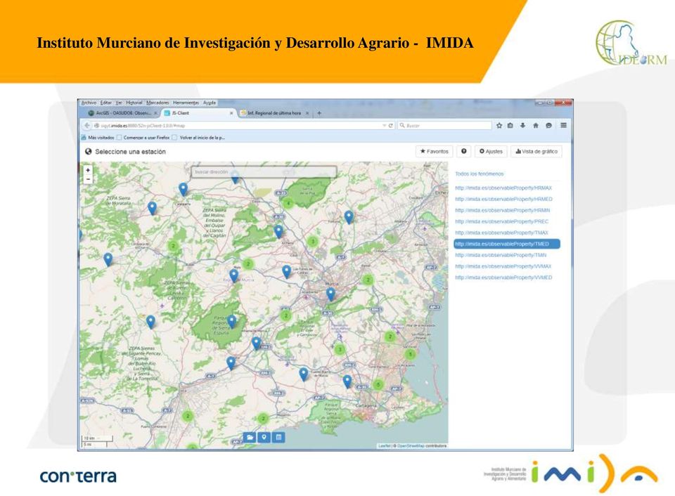
15 SOS services + client for observations Visualize stations and observations data Set-up JavaScript Client for SOS

16 SOS Client

17
18 Lessons Learned FME Processes can be updated and extended with further themes/ phenomena FME processes can be automated (actualization of data) SOS provides OGC standardized interface for observation data direct and flexible access to observation data of the weather stations with SOS clients significant benefit in the use of sensor data

19 Project outlook Process data on site Add real time observations to SOS Automation of data transformation Hourly data update (FME Server Scheduler & Notifications) Add more phenomena Adjust mapping
 Add more phenomena")
20 SIGyT team. Person Title Contact details Manuel Erena Agronomist engineer (Coordinator) Pedro García Software engineer Diana Sánchez Software engineer Joaquín F. Atenza Geographer Juan Antonio López Software engineer Marta Sánchez Degree in communication Daniel I. Paya Pina Agronomist engineer con terra / 52 North team. Person Title Contact details Benjamin Quest Technical sales b.quest@conterra.de Sören Dupke Software engineer s.dupke@conterra.de Dr. Simon Jirka Sensor Web Community Lead s.jirka@52north.org Carsten Hollmann Software developer c.hollmann@52north.org

21 Webinar: July, 2nd 2015, 3:00 p.m. Simplifying INSPIRE Challenges with FME INSPIRE Schema Mapping made easy Generation of INSPIRE GML and ATOM Feeds INSPIRE Solution Pack 2.0 (incl. annexes I, II, III)
Transforming Data with FME for Inspire
 Transforming Data with FME for Inspire Ken Bragg @KenAtSafe European Services Manager Safe Software INSPIRE KEN & EuroSDR Schema Transformation Workshop ENSG - Marne-La-Vallée October 9 th 2013 Agenda
Sextant. Spatial Data Infrastructure for Marine Environment. C. Satra Le Bris, E. Quimbert, M. Treguer
 Sextant On-Line information system for marine geographical information E. Quimbert, M. Bellouis, F. Lecuy, M. Treguer Centre de Bretagne BP 70, Plouzané 29280 France E-mail: sextant@ifremer.fr Sextant
Systèmes de mesures OGC compliant pour le monitoring des infrastructures dans le Projet ISTIMES
 Integrated System for Transport Infrastructures surveillance and Monitoring by Electromagnetic Sensing Systèmes de mesures OGC compliant pour le monitoring des infrastructures dans le Projet ISTIMES 3
GeoKettle: A powerful open source spatial ETL tool
 GeoKettle: A powerful open source spatial ETL tool FOSS4G 2010 Dr. Thierry Badard, CTO Spatialytics inc. Quebec, Canada tbadard@spatialytics.com Barcelona, Spain Sept 9th, 2010 What is GeoKettle? It is
Jiří Kadlec and Daniel P. Ames*
 AWRA 2012 SPRING SPECIALTY CONFERENCE New Orleans, Louisiana March 26 28, 2012 Copyright 2012 AWRA DEVELOPMENT OF A LIGHTWEIGHT HYDROSERVER AND HYDROLOGIC DATA HOSTING WEBSITE Jiří Kadlec and Daniel P.
Use of OGC Sensor Web Enablement Standards in the Meteorology Domain. in partnership with
 Use of OGC Sensor Web Enablement Standards in the Meteorology Domain in partnership with Outline Introduction to OGC Sensor Web Enablement Standards Web services Metadata encodings SWE as front end of
TexasET Network Water My Yard Program
 TexasET Network Water My Yard Program What is the Water My Yard Program? The WaterMyYard Program (http://watermyyard.org) is a new program and website that solves two of the biggest problems in getting
Development of Sensor Web Applications with Open Source Software
 Development of Sensor Web Applications with Open Source Software Arne Bröring1, Eike Hinderk Jürrens1, Simon Jirka1, Christoph Stasch2 1 52 North Initiative for Geospatial Open Source Software GmbH {broering,
GIS Data Models for INSPIRE and ELF
 GIS Data Models for INSPIRE and ELF Paul Hardy Roberto Lucchi EuroSDR/ELF Copenhagen Data Modelling and Model Driven Implementation of Data Distribution 28 Jan 2015 ArcGIS for INSPIRE Extends ArcGIS for
Cloud-based Infrastructures. Serving INSPIRE needs
 Cloud-based Infrastructures Serving INSPIRE needs INSPIRE Conference 2014 Workshop Sessions Benoit BAURENS, AKKA Technologies (F) Claudio LUCCHESE, CNR (I) June 16th, 2014 This content by the InGeoCloudS
Nevada NSF EPSCoR Track 1 Data Management Plan
 Nevada NSF EPSCoR Track 1 Data Management Plan August 1, 2011 INTRODUCTION Our data management plan is driven by the overall project goals and aims to ensure that the following are achieved: Assure that
THE GEORGIA AUTOMATED ENVIRONMENTAL MONITORING NETWORK: TEN YEARS OF WEATHER INFORMATION FOR WATER RESOURCES MANAGEMENT
 THE GEORGIA AUTOMATED ENVIRONMENTAL MONITORING NETWORK: TEN YEARS OF WEATHER INFORMATION FOR WATER RESOURCES MANAGEMENT Gerrit Hoogenboom, D.D. Coker, J.M. Edenfield, D.M. Evans and C. Fang AUTHORS: Department
WP 3. Elaboration database Architecture Features (Software Architecture Document)
") Architecture Features (Software Architecture Document) o Best in class solution, using EC recommendations for IT in this field o Implementation based on free open source o Based on OGC standards, high
Architecture Features (Software Architecture Document) o Best in class solution, using EC recommendations for IT in this field o Implementation based on free open source o Based on OGC standards, high
EarthServer @ RDA. RDA: Co-chairing - Big Data IG - Geospatial IG. OGC co-chairing: - editor, Big Geo Data stds - BigData.DWG
 RDA: Co-chairing - Big Data IG - Geospatial IG OGC co-chairing: - editor, Big Geo Data stds - BigData.DWG EarthServer @ RDA RDA-DE/DINI Workshop, Karlsruhe, 2015-may-29 Peter Baumann Jacobs University
Application of cloud based sensor data infrastructure for agricultural information service in Hokkaido Japan
 Application of cloud based sensor data infrastructure for agricultural information service in Hokkaido Japan APAN 36th Meeting 20 Aug 2014 HONDA Kiyoshi: Chubu University Apichon Witayangkurn: University
Leveraging Cloud-Based Mapping Solutions
 Leveraging Cloud-Based Mapping Solutions GeoAlberta October 28, 2014 Laura Kerssens Safe Software Agenda To the Cloud Using Basic Services Cloud Applications Web Services Cloud-Hosted Databases Real-time
EXPLORING AND SHARING GEOSPATIAL INFORMATION THROUGH MYGDI EXPLORER
 EXPLORING AND SHARING GEOSPATIAL INFORMATION THROUGH MYGDI EXPLORER Subashini Panchanathan Malaysian Centre For Geospatial Data Infrastructure ( MaCGDI ) Ministry of National Resources and Environment
Scenario Management System
 Scenario Management System Scenario Management System Sascha Schlobinski cismet GmbH Topics SUDPLAN Scenario Management System Core Functionalities Potential Use Background SUDPLAN Dimensions Advanced
Call for experts for INSPIRE maintenance & implementation
 INSPIRE Infrastructure for Spatial Information in Europe Call for experts for INSPIRE maintenance & implementation Title Creator Call for experts for INSPIRE maintenance & implementation EC & EEA INSPIRE
PART 1. Representations of atmospheric phenomena
 PART 1 Representations of atmospheric phenomena Atmospheric data meet all of the criteria for big data : they are large (high volume), generated or captured frequently (high velocity), and represent a
Product Navigator User Guide
 Product Navigator User Guide Table of Contents Contents About the Product Navigator... 1 Browser support and settings... 2 Searching in detail... 3 Simple Search... 3 Extended Search... 4 Browse By Theme...
mdwfs Model-driven Schema Translation for Integrating Heterogeneous Geospatial Data
 mdwfs Model-driven Schema Translation for Integrating Heterogeneous Geospatial Data Tatjana Kutzner, Andreas Donaubauer Chair of Geoinformatics kutzner@tum.de INSPIRE KEN Schema Transformation Workshop,
African European Georesources Observation System
 African European Georesources Observation System Spatial Data Infrastructure (SDI) Dr. Andreas Barth, Bernd Torchala Beak, Germany Outline Project Overview AEGOS SDI data / services hardware / software
Enabling embedded maps
 Enabling embedded maps Case: National geoportal of Finland Antti Rainio National Land Survey of Finland Trends: Web Services, Mapping Mashup, Open Source, Open Data Decentralised data s Service interfaces
WMO Climate Database Management System Evaluation Criteria
 ANNEX 8 WMO Climate Database Management System Evaluation Criteria System Name: Version: Contributing Country: Contact Information Contact Person: Telephone: FAX: Email address: Postal address: Date: General
Geo Mindstorms. Investigating a sensor information framework for disaster management processes. Steven Fruijtier Geodan S&R
 Geo Mindstorms Investigating a sensor information framework for disaster management processes Steven Fruijtier Geodan S&R Content > Sensors in disaster management Use of sensors Problems encountered as
Database and Analytical Tool Development for the Management of Data Derived from US DOE (NETL) Funded Fine Particulate (PM 2.
 Funded Fine Particulate (PM 2.") Database and Analytical Tool Development for the Management of Data Derived from US DOE (NETL) Funded Fine Particulate (PM 2.5 ) Research Project Objectives Primary objective is to develop a comprehensive,
Database and Analytical Tool Development for the Management of Data Derived from US DOE (NETL) Funded Fine Particulate (PM 2.5 ) Research Project Objectives Primary objective is to develop a comprehensive,
GEOCOM PROJECT INTEGRATING DATA & TECHONOLOGIES
 GEOCOM PROJECT INTEGRATING DATA & TECHONOLOGIES Lucio Colaiacomo Chief Technology Officer l.colaiacomo@eusc.europa.eu Rationale for the project Providing support through our domain background & tech. expertise
Wireless Soil Moisture and Weather Monitoring System Caipos
 Wireless Soil Moisture and Weather Monitoring System Caipos System Overview Soil moisture and weather monitoring systems Caipos System Overview Caipos consists of base station, sensors and web application.
INSPIRE Metadata Survey Results
 INSPIRE Metadata Survey Results Joanna Nowak and Massimo Craglia Institute for Environment and Sustainability 2006 EUR 22488 EN The mission of the Institute for Environment and Sustainability is to provide
Observation Metadata and its Use in the DWD Weather Data Request Broker
 Observation Metadata and its Use in the DWD Weather Data Request Broker Jürgen Seib Deutscher Wetterdienst e-mail: juergen.seib@dwd.de What kind of metadata is needed for the discovery of observation data?
Wildfire Prevention and Management in a 3D Virtual Environment
 Wildfire Prevention and Management in a 3D Virtual Environment M. Castrillón 1, P.A. Jorge 2, I.J. López 3, A. Macías 2, D. Martín 2, R.J. Nebot 3,I. Sabbagh 3, J. Sánchez 2, A.J. Sánchez 2, J.P. Suárez
visualization tool for interpretation of empirical results from climate model: Does it add value to UbuntuNet Connect Kigali, Rwanda 2013
 Development of a climate data visualization tool for interpretation of empirical results from climate model: Does it add value to different stakeholders? UbuntuNet Connect Kigali, Rwanda 2013 Co-Authors
Data interchange between Web client based task controllers and management information systems using ISO and OGC standards
 Data interchange between Web client based task controllers and management information systems using ISO and OGC standards Michael Nørremark 1*, Ole Jørgensen 1, Jens Bligaard 2 and Claus G. Sørensen 1
Welcome to NASA Applied Remote Sensing Training (ARSET) Webinar Series
 Webinar Series") Welcome to NASA Applied Remote Sensing Training (ARSET) Webinar Series Introduction to Remote Sensing Data for Water Resources Management Course Dates: October 17, 24, 31 November 7, 14 Time: 8-9 a.m.
Welcome to NASA Applied Remote Sensing Training (ARSET) Webinar Series Introduction to Remote Sensing Data for Water Resources Management Course Dates: October 17, 24, 31 November 7, 14 Time: 8-9 a.m.
MONITORING SOLUTION FOR IMPROVED CROP MANAGEMENT
 MONITORING SOLUTION FOR IMPROVED CROP MANAGEMENT COMPREHENSIVE, REAL-TIME INFORMATION SYSTEM FOR DECISION MAKING 01-0113-WTS-BR-0099-EN GROW MORE WITH LESS WWW.NETAFIM.COM REAL-TIME MONITORING AND DECISION
City Data Pipeline. A System for Making Open Data Useful for Cities. stefan.bischof@tuwien.ac.at
 City Data Pipeline A System for Making Open Data Useful for Cities Stefan Bischof 1,2, Axel Polleres 1, and Simon Sperl 1 1 Siemens AG Österreich, Siemensstraße 90, 1211 Vienna, Austria {bischof.stefan,axel.polleres,simon.sperl}@siemens.com
A RDF Vocabulary for Spatiotemporal Observation Data Sources
 A RDF Vocabulary for Spatiotemporal Observation Data Sources Karine Reis Ferreira 1, Diego Benincasa F. C. Almeida 1, Antônio Miguel Vieira Monteiro 1 1 DPI Instituto Nacional de Pesquisas Espaciais (INPE)
What s new in Carmenta Server 4.2
 What s new in Carmenta Server 4.2 A complete solution for cost-effective visualisation and distribution of GIS data through web services Carmenta Server provides cost-effective technology for building
An Esri White Paper June 2011 ArcGIS for INSPIRE
 An Esri White Paper June 2011 ArcGIS for INSPIRE Esri, 380 New York St., Redlands, CA 92373-8100 USA TEL 909-793-2853 FAX 909-793-5953 E-MAIL info@esri.com WEB esri.com Copyright 2011 Esri All rights reserved.
SatelliteRemoteSensing for Precision Agriculture
 SatelliteRemoteSensing for Precision Agriculture Managing Director WasatSp. z o.o. Copernicus the road to economic development Warsaw, 26-27 February 2015 Activitiesof WasatSp. z o.o. The company provides
Bringing spatial data and metadata from long term ecosystem research domain to the INSPIRE world
 Bringing spatial data and metadata from long term ecosystem research domain to the INSPIRE world Tomas Kliment Junior Researcher Italian National Research Council Institute of Marine Sciences in Venice
INSPIRE in practice: Experiences with INSPIRE data and services
 INSPIRE in practice: Experiences with INSPIRE data and services Peter Parslow Principal Geographic Information Architect June 2014: ISO TC211 Standards in Practice workshop What s INSPIRE? European Commission
Task AR-09-01a Progress and Contributions
 Doug Nebert, POC U.S. Geological Survey ddnebert@usgs.gov March 2010 Task AR-09-01a Progress and Contributions Background and scope for AR-09-01a This Task defines the minimum, common technical capabilities
The Spatial Data Infrastructure of Spain as an example of success in Europe *
 UNITED NATIONS E/CONF.99/IP.16 ECONOMIC AND SOCIAL COUNCIL Ninth United Nations Regional Cartographic Conference for the Americas New York, 10-14 August 2009 Item 7(b) of the provisional agenda Best Practices
Managing a Geographic Database From Mobile Devices Through OGC Web Services
 Managing a Geographic Database From Mobile Devices Through OGC Web Services Nieves R. Brisaboa 1, Miguel R. Luaces 1, Jose R. Parama 1, and Jose R. Viqueira 2 1 Database Laboratory, University of A Coruña,
CEOS Water Portal Status Update
 CEOS Water Portal Status Update Satoko Horiyama MIURA / Atsushi KAWAI JAXA/Mission Operations System Office WGISS-31 Introduction CEOS Water Portal is ; A web based portal system evolved from Distributed
SDI Workshop ESDIN Best Practices. 2011-06-28 INSPIRE conference, Edinburgh. Arnulf Christl, Metaspatial
 SDI Workshop ESDIN Best Practices 2011-06-28 INSPIRE conference, Edinburgh Arnulf Christl, Metaspatial Download this slide set as ODP (1.2MB) or PDF (1.1MB) at http://arnulf.us/publications Arnulf Christl
istsos: latest developments and first steps into the OSGeo incubation process
 istsos: latest developments and first steps into the OSGeo incubation process Massimiliano Cannata, Milan P. Antonovic, Mirko Cardoso FREE AND OPEN SOURCE SOFTWARE FOR GEOSPATIAL: TOWARD DIVERSITY! SEPTEMBER
Transformation architecture. From production data base to INSPIRE data using WFS: potential methods
 Transformation architecture From production data base to INSPIRE data using WFS: potential methods Inspire KEN Paris 2013-10-08 Frank Arntsen and Morten Borrebæk Background Based on ELF / ESDIN experiences
COSTE: a Web-Services Infrastructure Enabling Interoperability and Integration of Spatial and Traffic e-contents for European Regions
 COSTE: a Web-s Infrastructure Enabling Interoperability and Integration of Spatial and Traffic e-contents for European Regions Marco Boero Softeco Sismat SpA Italy Geographic Information: Motivation, problem
CDI/THREDDS Interoperability: the SeaDataNet developments. P. Mazzetti 1,2, S. Nativi 1,2, 1. CNR-IMAA; 2. PIN-UNIFI
 CDI/THREDDS Interoperability: the SeaDataNet developments P. Mazzetti 1,2, S. Nativi 1,2, 1. CNR-IMAA; 2. PIN-UNIFI Outline Interoperability Issues in SeaDataNet A broker solution for CDI/THREDDS interoperability
Linking Sensor Web Enablement and Web Processing Technology for Health-Environment Studies
 Linking Sensor Web Enablement and Web Processing Technology for Health-Environment Studies Simon Jirka 1, Stefan Wiemann 2, Johannes Brauner 2, and Eike Hinderk Jürrens 1 1 52 North Initiative for Geospatial
1. Overview and Status Update (Satoko) : 10min. 2. Demonstration (Yoshi) : 20min. 3. New Architecture (Yoshi): 15min. 4. Q&A, Discussion (All) : 15min
 : 10min. 2. Demonstration (Yoshi) : 20min. 3. New Architecture (Yoshi): 15min. 4. Q&A, Discussion (All) : 15min") 1. Overview and Status Update (Satoko) : 10min 2. Demonstration (Yoshi) : 20min 3. New Architecture (Yoshi): 15min 4. Q&A, Discussion (All) : 15min 1 CEOS Water Portal Overview and Status Update WGISS-37
1. Overview and Status Update (Satoko) : 10min 2. Demonstration (Yoshi) : 20min 3. New Architecture (Yoshi): 15min 4. Q&A, Discussion (All) : 15min 1 CEOS Water Portal Overview and Status Update WGISS-37
Accessing Geographic Information Services and Visualization Products at NOAA s National Climatic Data Center
 Accessing Geographic Information Services and Visualization Products at NOAA s National Climatic Data Center Rich Baldwin *, Steve Ansari, and Neal Lott NOAA National Climatic Data Center, Asheville, North
Final Report - HydrometDB Belize s Climatic Database Management System. Executive Summary
 Executive Summary Belize s HydrometDB is a Climatic Database Management System (CDMS) that allows easy integration of multiple sources of automatic and manual stations, data quality control procedures,
Environmental Data Services for Delaware:
 Environmental Data Services for Delaware: Serving Emergency Responders, Planners, and Researchers Network Delaware Day November 6, 2013 Overview Operational Data Services More than just research DEOS and
Harmonizing Survey Deliverables Emerging Standards and Smart Data Exchange
 Harmonizing Survey Deliverables Emerging Standards and Smart Data Exchange Andy Hoggarth and Karen Cove, CARIS, Fredericton, Canada Introduction When a survey company plans a project the deliverables are
GIS Initiative: Developing an atmospheric data model for GIS. Olga Wilhelmi (ESIG), Jennifer Boehnert (RAP/ESIG) and Terri Betancourt (RAP)
, Jennifer Boehnert (RAP/ESIG) and Terri Betancourt (RAP)") GIS Initiative: Developing an atmospheric data model for GIS Olga Wilhelmi (ESIG), Jennifer Boehnert (RAP/ESIG) and Terri Betancourt (RAP) Unidata seminar August 30, 2004 Presentation Outline Overview
GIS Initiative: Developing an atmospheric data model for GIS Olga Wilhelmi (ESIG), Jennifer Boehnert (RAP/ESIG) and Terri Betancourt (RAP) Unidata seminar August 30, 2004 Presentation Outline Overview
Web-Based Spatial Data Infrastructure (SDI) to Implement and Monitor Nonpoint Source (NPS) Pollution Management in the Imperial Valley, California
 to Implement and Monitor Nonpoint Source (NPS) Pollution Management in the Imperial Valley, California") Web-Based Spatial Data Infrastructure (SDI) to Implement and Monitor Nonpoint Source (NPS) Pollution Management in the Imperial Valley, California University of Redlands The Redlands Institute Serene Ong
Web-Based Spatial Data Infrastructure (SDI) to Implement and Monitor Nonpoint Source (NPS) Pollution Management in the Imperial Valley, California University of Redlands The Redlands Institute Serene Ong
Cadastre in the context of SDI and INSPIRE
 Cadastre in the context of SDI and INSPIRE Dr. Markus Seifert Bavarian Administration for Surveying and Cadastre Cadastre in the digital age the approach in Germany 3 rd CLGE Conference, Hanover, 11.10.2012
Spanish examples IPR: Up to Date & Zones
 Spanish examples IPR: Up to Date & Zones 1 Spanish IPR examples We have chosen the open source option: Python Why Python? Easy to learn and understand for not it people and code can be freely used and
The ORIENTGATE data platform
 Seminar on Proposed and Revised set of indicators June 4-5, 2014 - Belgrade (Serbia) The ORIENTGATE data platform WP2, Action 2.4 Alessandra Nuzzo, Sandro Fiore, Giovanni Aloisio Scientific Computing and
A web system for display and analysis of real-time monitoring observations of small urbanized catchments in Lahti, Finland
 A web system for display and analysis of real-time monitoring observations of small urbanized catchments in Lahti, Finland Jiří Kadlec 1, Juhani Jarveläinen 1 1 Aalto University, Niemenkatu 73, 15140 Lahti,
Data Integration for ArcGIS Users Data Interoperability. Charmel Menzel, ESRI Don Murray, Safe Software
 Data Integration for ArcGIS Users Data Interoperability Charmel Menzel, ESRI Don Murray, Safe Software Product overview Extension to ArcGIS (optional) Jointly developed with Safe Software Based on Feature
Harmonizing Survey Deliverables Emerging Standards and Smart Data Exchange
 Harmonizing Survey Deliverables Emerging Standards and Smart Data Exchange Andy Hoggarth, CARIS 115 Waggoners Lane, Fredericton, New Brunswick, Canada andy.hoggarth@caris.com Karen Cove, CARIS 115 Waggoners
Geospatial Data Stewardship at an Interdisciplinary Data Center
 Geospatial Data Stewardship at an Interdisciplinary Data Center Robert R. Downs, PhD Senior Digital Archivist and Senior Staff Associate Officer or Research Acting Head of Cyberinfrastructure and Informatics
Primary author: Kaspar, Frank (DWD - Deutscher Wetterdienst), Frank.Kaspar@dwd.de
, Frank.Kaspar@dwd.de") Primary author: Kaspar, Frank (DWD - Deutscher Wetterdienst), Frank.Kaspar@dwd.de Co-authors: Johannes Behrendt (DWD - Deutscher Wetterdienst), Klaus-Jürgen Schreiber (DWD - Deutscher Wetterdienst) Abstract
Primary author: Kaspar, Frank (DWD - Deutscher Wetterdienst), Frank.Kaspar@dwd.de Co-authors: Johannes Behrendt (DWD - Deutscher Wetterdienst), Klaus-Jürgen Schreiber (DWD - Deutscher Wetterdienst) Abstract
ArcGIS Data Models Practical Templates for Implementing GIS Projects
 ArcGIS Data Models Practical Templates for Implementing GIS Projects GIS Database Design According to C.J. Date (1995), database design deals with the logical representation of data in a database. The
Establishment of Spatial Data Infrastructure within the Environmental Sector in Slovak Republic
 EnviroInfo 2005 (Brno) Informatics for Environmental Protection - Networking Environmental Information Establishment of Spatial Data Infrastructure within the Environmental Sector in Slovak Republic Martin
Fairsail. Implementer. Fairsail to Active Directory Synchronization. Version 1.0 FS-PS-FSAD-IG-201310--R001.00
 Fairsail Implementer Fairsail to Active Directory Synchronization Version 1.0 FS-PS-FSAD-IG-201310--R001.00 Fairsail 2013. All rights reserved. This document contains information proprietary to Fairsail
RECOMMENDATIONS AND BEST PRACTICES FOR DATA SHARING IN NEW PROJECTS - THE FOT-NET DATA SHARING FRAMEWORK
 RECOMMENDATIONS AND BEST PRACTICES FOR DATA SHARING IN NEW PROJECTS - THE FOT-NET DATA SHARING FRAMEWORK 10 March 2015 Helena Gellerman, SAFER INTRODUCTION New projects retrieving data in two ways Collecting
Integration of location based services for Field support in CRM systems
 Invited Contribution to GeoInformatics. Deadline September 15, 2001. Integration of location based services for Field support in CRM systems By P. Álvarez, J.A. Bañares, P.R. Muro-Medrano and F.J. Zarazaga
Mr. Apichon Witayangkurn apichon@iis.u-tokyo.ac.jp Department of Civil Engineering The University of Tokyo
 Sensor Network Messaging Service Hive/Hadoop Mr. Apichon Witayangkurn apichon@iis.u-tokyo.ac.jp Department of Civil Engineering The University of Tokyo Contents 1 Introduction 2 What & Why Sensor Network
A Web services solution for Work Management Operations. Venu Kanaparthy Dr. Charles O Hara, Ph. D. Abstract
 A Web services solution for Work Management Operations Venu Kanaparthy Dr. Charles O Hara, Ph. D Abstract The GeoResources Institute at Mississippi State University is leveraging Spatial Technologies and
CentropeSTATISTICS a Tool for Cross-Border Data Presentation Manfred Schrenk, Clemens Beyer, Norbert Ströbinger
 Manfred Schrenk, Clemens Beyer, Norbert Ströbinger (Dipl.-Ing. Manfred Schrenk, Multimediaplan.at, 2320 Schwechat, Austria, schrenk@multimediaplan.at) (Dipl.-Ing. Clemens Beyer, CORP Competence Center
Wind Plant Operator Data Guide
 GUIDE 09 Wind Plant Operator Data Guide June 2016 Version: 2.1 Effective Date: 06/23/2016 This document was prepared by: NYISO Customer Support New York Independent System Operator 10 Krey Blvd Rensselaer,
MEETING OF THE EXPERT GROUP ON AGRICULTURAL DROUGHT INDICES. (Murcia, Spain, 2-4 June 2010) LIST OF PARTICIPANTS
 LIST OF PARTICIPANTS") MEETING OF THE EXPERT GROUP ON AGRICULTURAL DROUGHT INDICES (Murcia, Spain, 2-4 June 2010) Mr Emmanuel CLOPPET Meteo-France 42 avenue Coriolis F-31057 TOULOUSE CEDEX 1 France Tel: +33561 078381 Fax: +33561
MEETING OF THE EXPERT GROUP ON AGRICULTURAL DROUGHT INDICES (Murcia, Spain, 2-4 June 2010) Mr Emmanuel CLOPPET Meteo-France 42 avenue Coriolis F-31057 TOULOUSE CEDEX 1 France Tel: +33561 078381 Fax: +33561
Gathering and Managing Environmental Quality Data for Petroleum Projects ABSTRACT
 Gathering and Managing Environmental Quality Data for Petroleum Projects Dr. David W. Rich, President, Geotech Computer Systems, Inc., Englewood, CO ABSTRACT Petroleum environmental projects face special
Satellite Products and Dissemination: Visualization and Data Access
 Satellite Products and Dissemination: Visualization and Data Access Gregory Leptoukh GES DISC, NASA GSFC Dana Ostrenga GES DISC, NASA GSFC Introduction The Goddard Earth Sciences Data and Information Services
Using Wireless Sensor Networks in the Sensor Web for Flood Monitoring in Brazil
 Using Wireless Sensor Networks in the Sensor Web for Flood Monitoring in Brazil Lívia C. Degrossi, degrossi@icmc.usp.br Guilherme G. do Amaral ggentil@grad.icmc.usp.br Eduardo S. M. de Vasconcelos esmv@grad.icmc.usp.br
Data Interoperability Extension Tutorial
 Data Interoperability Extension Tutorial Copyright 1995-2010 Esri All rights reserved. Table of Contents About the Data Interoperability extension tutorial...................... 3 Exercise 1: Using direct-read
THE EUROPEAN DATA PORTAL
 European Public Sector Information Platform Topic Report No. 2016/03 UNDERSTANDING THE EUROPEAN DATA PORTAL Published: February 2016 1 Table of Contents Keywords... 3 Abstract/ Executive Summary... 3 Introduction...
REACCH PNA Data Management Plan
 REACCH PNA Data Management Plan Regional Approaches to Climate Change (REACCH) For Pacific Northwest Agriculture 875 Perimeter Drive MS 2339 Moscow, ID 83844-2339 http://www.reacchpna.org reacch@uidaho.edu
Minerals4EU - WP5 The EU-MKDP (Minerals Knowledge Data Platform)
") Minerals4EU - WP5 The EU-MKDP (Minerals Knowledge Data Platform) System architecture, objectives, services 1st MINCE Conference, Espoo, November 26-27, 2014 Daniel Cassard and the WP5 Team BRGM, CGS, GeoZS,
Minerals4EU - WP5 The EU-MKDP (Minerals Knowledge Data Platform) System architecture, objectives, services 1st MINCE Conference, Espoo, November 26-27, 2014 Daniel Cassard and the WP5 Team BRGM, CGS, GeoZS,
Software Design Proposal Scientific Data Management System
 Software Design Proposal Scientific Data Management System Alex Fremier Associate Professor University of Idaho College of Natural Resources Colby Blair Computer Science Undergraduate University of Idaho
Building & Developing the Environmental
 Building & Developing the Environmental Web Explorer for Riyadh City Authors: Engineer Yousef Bin Othman Al-Fariheedi Manager of Environmental Data Unit Environmental Management and Protection Department
WORLD WEATHER ONLINE
 WORLD WEATHER ONLINE XML Premium Weather Data Feed API Documentation Weather foreast by Postcode, Zipcode, Latitude and Longitude version 2.6 updated 11 th January, 2010 Index 1. Weather by Postcode, zipcode
GetLOD - Linked Open Data and Spatial Data Infrastructures
 GetLOD - Linked Open Data and Spatial Data Infrastructures W3C Linked Open Data LOD2014 Roma, 20-21 February 2014 Stefano Pezzi, Massimo Zotti, Giovanni Ciardi, Massimo Fustini Agenda Context Geoportal
UK Location Programme
 Location Information Interoperability Board Data Publisher How To Guide Understand the background to establishing an INSPIRE View Service using GeoServer DOCUMENT CONTROL Change Summary Version Date Author/Editor
Software platforms for Collecting, Managing and Providing Monitoring Data for Food and Agricultural Products
 Software platforms for Collecting, Managing and Providing Monitoring Data for Food and Agricultural Products Japan Atomic Energy Agency Center for Computational Science and E-systems Hiroshi Takemiya Observed
Ubiquitous Wireless Sensor Networks for Environmental and Climate Data Management System
 Ubiquitous Wireless Sensor Networks for Environmental and Climate Data Management System Presenter: M.Eng Vo Minh Thanh School of Electrical Engineering International University HCM National University
Monitoring Global Crop Condition Indicators Using a Web-Based Visualization Tool
 Monitoring Global Crop Condition Indicators Using a Web-Based Visualization Tool Bob Tetrault, Regional Commodity Analyst, and Bob Baldwin, GIS Specialist, USDA, Foreign Agricultural Service, Washington,
Using standards for ocean data
 Pan-European infrastructure for marine and ocean data management Using standards for ocean data By Dick M.A. Schaap SeaDataNet Technical Coordinator Vienna, April 09 Supported by the European Commission
NASA DEVELOP s 3-D Visualizations and Remote Sensing Applications. NASA DEVELOP, a student-led project headquartered at NASA Langley, allows
 Abstract NASA DEVELOP, a student-led project headquartered at NASA Langley, allows students to demonstrate remote-sensing techniques that are used to create visualizations, which aid communities in solving
How To Install The Arcgis For Inspire Server Extension On A Microsoft Gis For Inspire Server Extension (For Microsoft) On A Pc Or Macbook Or Ipa (For Macbook)
 On A Pc Or Macbook Or Ipa (For Macbook)") ArcGIS 10.2.1 for INSPIRE Server Extension Installation Guide Content 1 Introduction... 1 2 System Requirements... 1 3 Installation... 1 4 Software Authorization... 2 5 Changes to the System... 2 6 Performance
ArcGIS 10.2.1 for INSPIRE Server Extension Installation Guide Content 1 Introduction... 1 2 System Requirements... 1 3 Installation... 1 4 Software Authorization... 2 5 Changes to the System... 2 6 Performance
Geographic Information Systems Specialist
 Ministry of Communications and Information Technology Information Technology Institute Geographic Information Systems Specialist Intake 34 Introducing Track History Since 1993, GIS Platform has graduated
GENESIS Employing Web Processing Services and Sensor Web Technology for Environmental Management
 GENESIS Employing Web Processing Services and Sensor Web Technology for Environmental Management Steven Smolders (1), Christian Alegre (2), Simone Gianfranceschi (3), Marc Gilles (4), Bernd Resch (5),
CAPRA Software Gabriel Bernal ITEC SAS - ERN-AL Consortium
 CAPRA Software Gabriel Bernal ITEC SAS - ERN-AL Consortium ERN CAPRA software CAPRA platform Data management FileCAT Hazard module Exposure module Vulnerability module Risk module CRISIS 2007 ERN-NH rainfall
Interoperable Solutions in Web-based Mapping
 ISPRS SIPT IGU UCI CIG ACSG Table of contents Table des matières Authors index Index des auteurs Search Recherches Exit Sortir Interoperable Solutions in Web-based Mapping Marta Wojnarowska and Bridget