Telemetry, Gestion intégrée des données temps réel du Réseau d Observation
|
|
|
- Doris Mason
- 8 years ago
- Views:
Transcription
1 Colloque International sur la Gestion intégrée des Ressources en eau Telemetry, Gestion intégrée des données temps réel du Réseau d Observation Alpha Baro, Regional Manager Constantine 4-5 Juin 2012

2 Schlumberger Water Services (SWS) Vancouver Calgary Waterloo Delft Paris Sacramento Houston Tripoli Riyadh UAE s Recife Santiago Rio de Janeiro Perth Technology centers Projects Business development

3 Components

4 SWS Software Portfolio Acquire Manage Analyze Model Simulate ModFlow - finite difference -USGS Avocet -SIS Petrel -SIS Eclipse - finite volume -SIS

5

6 Our Services Information Management Water Resources Management Aquifer Storage & Recovery (ASR) Effluent Disposal Surface Hydrology- Rainwater Recharge Pollution Environmental Risk & Assessment Alternative Seawater Intake Mine Water Management Oilfield Water Management Hydrogeological Studies & Well Field Design

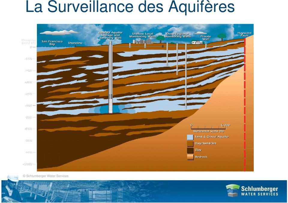
7 La Surveillance des Aquifères
8 Domaine d activité Charactérisatio n Suivi /Capteurs Gestion des Données Modèle Implémentatio n Simulatio n

9 Gestion intégrées des données Other Databases Hydrogeologic data GIS & other applications Real-time data/ Telemetry Documents Reports HydroManager Web Interface Customer data Contracts, Financial Human Resources Logistics, Maintenance Projects, Planning SQL Server Security Security Local Network Wide Network Staff & Consultants Regional Water Authorities

10 -Region 1 -Region 2 -Region 3 -Region 4 -Region 5

11

12

13 Generation en temps reel des cartes et des Rapports Concentration Contouring Thickness, K, etc Contouring Water Level Contouring

14 Water Quality Salinity mg/l TDS Water Level Changes between 1998 to 2003

15 Diver-NETZ Surveillance Temps Réel des Aquifères

16 Surveillance en temps reel Internet Logger Communcation Interface (LCI) GSM Modem GSM Service Provider FTP DRC Diver FTP HydroManager ADCS local WD3 CSV Flowmetres en temps réel Température Pression salinité en temps réel Systèmes a faible consommation d energie Invisible sécurisé contre le vandalisme Interactif avec HydroManager

17 Diver-NETZ - Mobile Diver- Gate(M) Smartphon e Bluetooth < 500 m GPRS Diver- DXT fileserver

18 Diver-NETZ - Telemtry Diver-Gate (S) GPRS Avocet-Hydro Diver-DXT

19 Components Diver-NETZ Diver-DXT (with cable and Diver): Short range radio (500 m LOS) Build-in baro data logger Battery life >5 years Diver-Gate(S) for fixed setup: Short range radio GPRS (Europe/us) External power supply Battery life >2 year (10Ah) Diver-Gate(M) for mobile use: Short range radio Bluetooth interface to pc Internal antennas Diver-Mobile: Rechargeable battery For windows Mobile Automatic data read Send data to ftp-server Other tools: Avocet-Hydro Labview tools

20 Workflow Diver-NETZ (Diver- Gate(S)) Diver-Gate(S) periodically wakes up (example: ones a day, user setting). Diver-Gate(S) scans for Diver-DXTs (takes 30sec). Diver-Gate(S) collects data from all Divers and Baros (last or All data, user setting). Diver-Gate(S) created one file ( *.dxt-file) and sends it to ftp-server. Diver-Gate(S) created a house keeping file ( *.log-file) and sends it to ftpserver. Diver-Gate(S) goes back in standby mode. Files are collected by Avocet-Hydro
 created one file ( *.dxt-file) and sends it to ftp-server. Diver-Gate(S) created a house keeping file ( *.")
21 Reasonable cost satellite data workflow modem provider receiver Example: Diver-Gate will be plugged to a Satellite modem like LeoCell Field Diver data will transit to a Satellite owned by Orbcomm, GlobalStar, Inmarsat Diver Data from the Satellite will be then sent periodically to the Satellite provider data center in Canada, US, UK Lastly, the Data Center will send Diver Data to end client by or to a server
22 Data management How do we manage the data?
23 Watercompany Vitens - Hollande 1,6 Million d abonnes 4,0 Million de personnes 270 Million m³ annuels 65 station de pompage 1200 puits de production 4500 puits d observation Obligés de prendre des mesures Tous les 14 jours/ 24 mesures par an Mesures manuelles Données exportées sur la base de donnée nationale
24 Radio Range to Diver-DXT Street pot: Diver-DXT is under ground level. Radio distance LOS 100m. Radio distance around corner 20m. Metal cover: Diver-DXT is 1m above ground level. Radio distance LOS 200m. Plastic cover: Diver-DXT is 1m above ground level but with vegetation. Radio distance LOS 200m.
25 Watercompany Vitens Today, 4500 Divers are used to monitor groundwater level On-Time data Delivery Solutions enabling customers to translate acquired data into useful information GIS Vizualisation QA/QC data Automatic reporting Data transfer to national database
26 Project Case : Gulf Country Projects: Groundwater rise monitoring project TSE Injection Project Objectives: Monitor the groundwater rise in residential area Monitor the TSE recharge plume
27 Extent of Injection Bubble 400m 13.6 MCM ~ 3 BIG Regionalizati on 500 5,000 7,500 10,000 12,500 15,00 µs/cm
28 South-North Profile Dammam Rus UER
29 Automation of monitoring points Brackish groundwater (1.600 µs/cm) 15x CTD Diver datalogger Measuring frequency: 1h No data gaps allowed Telemetry 15x DXT 6 Diver-Gate(S) Daily upload to FTP Diver-Gate (S)
30 Data delivery to Decision Makers
31 Westbay System Packer - independent hydraulic inflation Monitoring Zone Measurement Port - in-situ measurement, low-k testing, and for fluid sampling Casing - variable lengths Pumping Port - for hydraulic conductivity testing and purging
32
33 Case Studies CALIFORNIA Sacramento San Francisco FORT ORD Salinas Valley Los Angeles San Diego
34 Orange County Water District 57 Westbay Wells Depths to 600m ~550 Monitoring Zones That provide testing, monitoring and sampling
35 Former Fort Ord Cross Section 50 Elevation, m msl Upper Foot Aquifer Intermediate 8180Foot - Aquitard Lower Foot Aquifer Valley Fill Deposits Dune Sand Foot Aquifer Aromas/ Paso Robles Fm Horizontal Scale, m General Groundwater Flow Direction E After MACTEC E&C Carbon Tetrachloride Concentrations (µg/l) Chloride Concentrations (mg/l)
Communication Packages: Manual Method
 Communication Packages: Manual Method Diver USB Reading Unit Handheld connection PC connection Connect your PC, Laptop, or Pocket-PC to a Diver with the Reading Unit to: - Download data - Program settings
Multilevel Monitoring and Characterization of the Edwards and Trinity Aquifers of Central Texas
 Multilevel Monitoring and Characterization of the Edwards and Trinity Aquifers of Central Texas Brian A. Smith and Brian B. Hunt Barton Springs / Edwards Aquifer Conservation District, 1124 Regal Row,
Innovative Water Technologies Programs. 5 th Annual Summer Seminar 2015 San Antonio Water Systems July 24, 2015 By Erika Mancha
 Innovative Water Technologies Programs 5 th Annual Summer Seminar 2015 San Antonio Water Systems July 24, 2015 By Erika Mancha The following presentation is based upon professional research and analysis
RAPPORT FINANCIER ANNUEL PORTANT SUR LES COMPTES 2014
 RAPPORT FINANCIER ANNUEL PORTANT SUR LES COMPTES 2014 En application de la loi du Luxembourg du 11 janvier 2008 relative aux obligations de transparence sur les émetteurs de valeurs mobilières. CREDIT
AQUIFER STORAGE RECOVERY
 AQUIFER STORAGE RECOVERY This continuing education unit has been created to acquaint the reader with the topic of Aquifer Storage Recovery. The International School of Well Drilling gratefully acknowledges
January 24, 2012. John E. Meyer, P.G. Texas Water Development Board Water Science and Conservation Innovative Water Technologies
 January 24, 2012 John E. Meyer, P.G. Texas Water Development Board Water Science and Conservation Innovative Water Technologies State and regional water planning Recommended Water Management Strategies
Groundwater & Environmental Products Catalog
 CMYK Pantone Groundwater & Environmental Products Catalog Greyscale Black on White White on Black Groundwater Dataloggers multilevel sampling & monitoring Geo-environmental software Streamline Your Project
Groundwater flow systems theory: an unexpected outcome of
 Groundwater flow systems theory: an unexpected outcome of early cable tool drilling in the Turner Valley oil field K. Udo Weyer WDA Consultants Inc. weyer@wda-consultants.com Introduction The Theory of
COST AND PERFORMANCE REPORT
 COST AND PERFORMANCE REPORT Pump and Treat of Contaminated Groundwater at the United Chrome Superfund Site Corvallis, Oregon September 1998 Prepared by: SITE INFORMATION Identifying Information: United
Water Distribution System Wireless Monitoring Solutions
 Water Distribution System Wireless Monitoring Solutions Pump Station Aquifer Level Tank Level Reservoir Level Rainfall Mag Meter Flow Hydrant Pressure Water Quality Water Meter Flow Pressure Reducing Valve
Harris - Galveston Subsidence District
 Harris - Galveston Subsidence District History of Subsidence, Regulation, and Water Management in the Houston Region Michael J. Turco - General Manager ASSOCIATION OF WATER BOARD DIRECTORS GUEST LECTURE
Update on Aquifer Storage and Recovery
 Update on Aquifer Storage and Recovery Dean Powell Bureau Chief Water Supply Bureau Governing Board Workshop September 2013 Objectives Discuss the basics of aquifer storage and recovery (ASR) technology
GROUNDWATER RESOURCES MANAGEMENT IN SAUDI ARABIA
 GROUNDWATER RESOURCES MANAGEMENT IN SAUDI ARABIA Walid A. Abderrahman Professor, Water Resources Management President, Saudi Water Association Special Presentation at Water Conservation Workshop Khober,
 Geological Formations in the San Joaquin Valley -- Potential for Carbon Sequestration Dr. Jan Gillespie California State University Bakersfield Target formations for CO 2 storage Burruss et al., 2009
ALL GROUND-WATER HYDROLOGY WORK IS MODELING. A Model is a representation of a system.
 ALL GROUND-WATER HYDROLOGY WORK IS MODELING A Model is a representation of a system. Modeling begins when one formulates a concept of a hydrologic system, continues with application of, for example, Darcy's
Temperature & Humidity SMS Alert Controller
 Temperature & Humidity Alert Controller METERS 3 simple steps starting the unit: Insert the SIM card Plug in the sensors connectors Connect the AC power cord. Specifications: AC 90~260V Auto Select Internal
You can choose to install the plugin through Magento Connect or by directly using the archive files.
 Magento plugin 1.5.7 installation 1. Plugin installation You can choose to install the plugin through Magento Connect or by directly using the archive files. 1.1 Installation with Magento Connect 1.1.1
If you require assistance in obtaining access to the presentations or have questions regarding the. 6300 or Glenn Young at (916) 341 6696.
 341 6696.") These materials were developed by CalRecycle staff to address specific technical training areas and are posted as reference documents for the local l government and CalRecycle staff who work on closed,
These materials were developed by CalRecycle staff to address specific technical training areas and are posted as reference documents for the local l government and CalRecycle staff who work on closed,
Principles of groundwater flow
 Principles of groundwater flow Hydraulic head is the elevation to which water will naturally rise in a well (a.k.a. static level). Any well that is not being pumped will do for this, but a well that is
Tight Gas Reservoirs R&D Project Approach
 Tight Gas Reservoirs R&D Project Approach EBN TNO Tight Gas Symposium Utrecht, September 19, 2006 Tight Gas Reservoirs: some definitions Applies to the sandstone and carbonate reservoirs, with all type
Total Water & Wastewater Management for Shale Gas Production. Treatment and Operation Solutions
 Total Water & Wastewater Management for Shale Gas Production Treatment and Operation Solutions Impact of Water and Wastewater from Shale Gas Fracturing Operations As the number of shale gas fracturing
The Role of Groundwater in Alberta s Tight Water Supply Environment. Ken Baxter, M.Sc., P.Geol. Dan R. Brown, M.Sc., P.Geol.
 The Role of Groundwater in Alberta s Tight Water Supply Environment Ken Baxter, M.Sc., P.Geol. Dan R. Brown, M.Sc., P.Geol. The Role of Groundwater in Alberta s Tight Water Supply Environment Outline Importance
4. Environmental Impacts Assessment and Remediation Targets
 4. Environmental Impacts Assessment and Remediation Targets 4.1 Environmental Impacts Significant additional development in the Alder Creek watershed is not anticipated at this time; however, there are
LOS ANGELES COUNTY S FLOODING HISTORY:
 LOS ANGELES COUNTY S FLOODING HISTORY: Since 1975, Los Angeles County has experienced twelve federally, declared flood disasters, with three of those disasters coming under El Niño conditions (1983, 1998,
4. Right click grid ( ) and select New MODFLOW, then select Packages, enabling both the optional Well and Recharge option.
 and select New MODFLOW, then select Packages, enabling both the optional Well and Recharge option.") Groundwater Hydrology CE 40460 Example 1 -- Grid Approach Building a grid is the first step in creating a groundwater model using GMS, and it requires the following components: top and bottom elevations,
Groundwater Hydrology CE 40460 Example 1 -- Grid Approach Building a grid is the first step in creating a groundwater model using GMS, and it requires the following components: top and bottom elevations,
How To Use A Water Quality Monitor (Wqmsw)
") Water Quality Monitor WQM Host Software User s Guide The user s guide is an evolving document. If you find sections that are unclear, or missing information, please let us know. Please check our website
Water Quality Monitor WQM Host Software User s Guide The user s guide is an evolving document. If you find sections that are unclear, or missing information, please let us know. Please check our website
Groundwater Quality Analysis Technical Memorandum / Phase 1 Between Mojave Water Agency and Schlumberger Water Services
 Groundwater Quality Analysis Technical Memorandum / Phase 1 Between Mojave Water Agency and Schlumberger Water Services May 7, 2007 Table of Contents Task 1 - Water Quality Data Compilation, Reconciliation,
Eau de pluie, pollution source non-ponctuelle, modèle de bassin versant MGEP (SWMM), pollutogramme, contrôle automatique
, pollutogramme, contrôle automatique") NOVATECH Development of an Automatic Monitoring System for the Assessment of Urban Wet-Weather Discharge in the DTV (Daedeok Techno Valley), Daejeon, Korea Développement d'un système automatique de surveillance
NOVATECH Development of an Automatic Monitoring System for the Assessment of Urban Wet-Weather Discharge in the DTV (Daedeok Techno Valley), Daejeon, Korea Développement d'un système automatique de surveillance
REGIONAL GROUNDWATER MONITORING REPORT CENTRAL AND WEST COAST BASINS LOS ANGELES COUNTY, CALIFORNIA WATER YEAR 2008-2009
 REGIONAL GROUNDWATER MONITORING REPORT CENTRAL AND WEST COAST BASINS LOS ANGELES COUNTY, CALIFORNIA WATER YEAR 2008-2009 Water Replenishment District of Southern California 4040 Paramount Boulevard Lakewood,
Groundwater Training Course SOPAC, April 2005. Electromagnetic (EM) Induction method for Groundwater Investigations
 Induction method for Groundwater Investigations") Groundwater Training Course SOPAC, April 2005 Electromagnetic (EM) Induction method for Groundwater Investigations Electromagnetic (EM) Induction Method Basic principle: An AC electric current is applied
Groundwater Training Course SOPAC, April 2005 Electromagnetic (EM) Induction method for Groundwater Investigations Electromagnetic (EM) Induction Method Basic principle: An AC electric current is applied
Paso Robles Groundwater Basin Management Plan Groundwater Level Monitoring Network Plan for the Paso Robles Groundwater Basin
 Paso Robles Groundwater Basin Management Plan Groundwater Level Monitoring Network Plan for the Paso Robles Groundwater Basin Paso Robles Groundwater Basin Groundwater Advisory Committee February 2011
LAND-SURFACE SUBSIDENCE IN THE HOUSTON-GALVESTON REGION, TEXAS
 LAND-SURFACE SUBSIDENCE IN THE HOUSTON-GALVESTON REGION, TEXAS Robert K. GABRYSCH? United States Geological Survey ABSTRACT In the Houston-Galveston region of Texas, the principal cause of land-surface
Guidelines For Sealing Groundwater Wells
 Guidelines For Sealing Groundwater Wells Government of Newfoundland and Labrador Department of Environment and Conservation Water Resources Management Division Government of Newfoundland and Labrador Department
1 0 0 1 e s p i o n s.com. V680 GPS Watch User s Manual
 1 V680 GPS Watch User s Manual 2 Table of Contents Chapter I Preface..4 I.General...4 II.Notices..4 Chapter II about the Device.5 1. Appearance..5 2. Product Features.5 3. Product Specification.6 (1).Technical
Quick Start Guide RRL Radio Telemetry
 Quick Start Guide RRL Radio Telemetry Antenna External Power Connection LED Activity Light RS232 Connection Serial Number Levelogger Connections RRL Station High Quality Groundwater and Surface Water Monitoring
4D reservoir simulation workflow for optimizing inflow control device design a case study from a carbonate reservoir in Saudi Arabia
 4D reservoir simulation workflow for optimizing inflow control device design a case study from a carbonate reservoir in Saudi Arabia O. Ogunsanwo, 1* B. Lee, 2 H. Wahyu, 2 E. Leung, 1 V. Gottumukkala 1
MAC-ENC-PRO-062 GROUNDWATER MONITORING PROGRAM
 MAC-ENC-PRO-062 GROUNDWATER MONITORING PROGRAM Document Owner Michael Gale, Superintendent Environment Analysis and Improvement Document Approver Sarah Withell, Head of Health, Safety and Environment Version
Subsurface storage And artificial recharge for sustainability
 Subsurface storage And artificial recharge for sustainability 27-10-2010 Theo Olsthoorn, Waternet, Worldwaternet and TU-Delft t.tn.olsthoorn@tudelft.nl Delft University of Technology Challenge the future
Water Quality monitoring in Tunisia
 Mediterranean water monitoring working group meeting Madrid, Spain November,10 th 2010 Water Quality monitoring in Tunisia Yousra BEN SALAH Ministry of Agriculture, Hydraulic Resources and Fishery Water
Hydrologic Data Program Overview. Rio Grande Estuary, and Lower Laguna Madre Basin and Bay Area Stakeholder Committee (BBASC)
") Hydrologic Data Program Overview Rio Grande Estuary, and Lower Laguna Madre Basin and Bay Area Stakeholder Committee (BBASC) J. Mark Null Chief South Texas Program Office USGS Texas Water Science Center
Hydrologic Data Program Overview Rio Grande Estuary, and Lower Laguna Madre Basin and Bay Area Stakeholder Committee (BBASC) J. Mark Null Chief South Texas Program Office USGS Texas Water Science Center
Nutrient Reduction by Use of Industrial Deep Injection Wells, Miami-Dade County, Florida
 GWPC September 27, 2015 Nutrient Reduction by Use of Industrial Deep Injection Wells, Miami-Dade County, Florida Virginia Walsh, PhD, P.G. Miami-Dade Water and Sewer Department Ed Rectenwald, P.G. MWH
WELCOMES ALL THE ATTENDEES WATER UTILISATION, MEASUREMENT AND METHODOLOGIES
 SUTRON india WELCOMES ALL THE ATTENDEES WATER UTILISATION, MEASUREMENT AND ABOUT SUTRON USA Strong Corporation was founded in 1975 Sutron Operates in : Hydrological Meteorological Oceanic Aviation Real-Time
IDD-213T User Manual. (Rev. 1.0) China Aerospace Telecommunications Limited
 China Aerospace Telecommunications Limited") (Rev. 1.0) China Aerospace Telecommunications Limited Contents 1. Introduction......3 2. Specifications...4 2.1 External Interface... 4 2.2 Status Indicator...... 5 2.3 Technical Parameters... 6 3. Device
(Rev. 1.0) China Aerospace Telecommunications Limited Contents 1. Introduction......3 2. Specifications...4 2.1 External Interface... 4 2.2 Status Indicator...... 5 2.3 Technical Parameters... 6 3. Device
Home Passport Gateway Series Simplify your Life with Smart Solutions
 Home Passport Gateway Series Simplify your Life with Smart Solutions HPGW Series - Home Passport Gateway Series HPGW Series is Home Passport Gateway, representing a breakthrough product in the intrusion
Frequency selective monitoring and logging of environmental electromagnetic fields
 FREQUENCY SELECTIVE EMF AREA MONITOR AMS-8060 Frequency selective monitoring and logging of environmental electromagnetic fields Up to 20 fully programmable frequency bands Real built-in spectrum analyser
Technical and Troubleshooting. Guide AIRAVE 2.5
 Technical and Troubleshooting Guide AIRAVE 2.5 Welcome! Sprint is committed to developing technologies addressing in-home coverage and ensuring you have a great wireless experience. This booklet provides
Overview. 1. GPS data tracking via GSM SMS / GPRS. 2. GPS data logging in internal memory. 3. Alarm alert via GSM SMS / Dialing / GPRS
 Vehicle or Personal Position Tracking Vehicle Status and Speed Tracking Auto Accident Report Global Position System (GPS) Navigation System Anti theft Alarm System Overview 1. GPS data tracking via GSM
ATTACHMENT 8: Quality Assurance Hydrogeologic Characterization of the Eastern Turlock Subbasin
 ATTACHMENT 8: Quality Assurance Hydrogeologic Characterization of the Eastern Turlock Subbasin Quality assurance and quality control (QA/QC) policies and procedures will ensure that the technical services
Mekong River transboundary water quality monitoring (learnings from a case study)
") RESEAU INTERNATIONAL DES ORGANISMES DE BASSIN INTERNATIONAL NETWORK OF BASIN ORGANIZATIONS 7EME ASSEMBLEE GENERALE MONDIALE DU 07 AU 09 JUIN 2007 A DEBRECEN (HONGRIE) Mekong River transboundary water quality
RESEAU INTERNATIONAL DES ORGANISMES DE BASSIN INTERNATIONAL NETWORK OF BASIN ORGANIZATIONS 7EME ASSEMBLEE GENERALE MONDIALE DU 07 AU 09 JUIN 2007 A DEBRECEN (HONGRIE) Mekong River transboundary water quality
Remote Sensing, GPS and GIS Technique to Produce a Bathymetric Map
 Remote Sensing, GPS and GIS Technique to Produce a Bathymetric Map Mark Schnur EES 5053 Remote Sensing Fall 2007 University of Texas at San Antonio, Department of Earth and Environmental Science, San Antonio,
GROUND WATER CONTAMINATION INFORMATION
 Ohio Department of Natural Resources Division of Oil and Gas Resources Management GROUND WATER CONTAMINATION INFORMATION Presence of Salty Water The salt that is normally found in contaminated water wells
National Groundwater Conference Canberra, November 2010
 DEVELOPMENT OF AN ADAPTIVE GROUNDWATER MONITORING FRAMEWORK TO INFORM SALINITY MANAGEMENT ACROSS THE VICTORIAN MALLEE REGION National Groundwater Conference Canberra, November 2010 Supported by the National
Deployment of networks of innovative water quality sensors for distribution network monitoring Joep van den Broeke (Ph.D.)
") AWWA Water Infrastructure Conference Deployment of networks of innovative water quality sensors for distribution network monitoring Joep van den Broeke (Ph.D.) 28 October 2014 Challenges for Water Utilities
AWWA Water Infrastructure Conference Deployment of networks of innovative water quality sensors for distribution network monitoring Joep van den Broeke (Ph.D.) 28 October 2014 Challenges for Water Utilities
Alberding precision agriculture solutions
 Alberding precision agriculture solutions Alberding GmbH AGRITECHNICA 2015, 8 14 November 2015, Hanover, Germany Presentation by: Tamás Horváth & Katrin Arendholz Alberding GmbH - Precision agriculture
SNQ-60x0-320 Series Data Center Switch. Quick Installation Guide
 Introduction This guide is to assist the reader with the most basic form of installation and connection to switches in this series. As there is more than one switch in this series, the diagrams might slightly
Monitoring of Tunnel End Plug Performance in ONKALO
 Monitoring of Tunnel End Plug Performance in ONKALO Erika Holt, VTT Technical Research Centre of Finland Presentation at IGDTP-Geodisposal 2014 Manchester, UK, 24th to 26th of June 2014 Co-authors: I.
Satellite Asset Tracking and Fleet Management (SATFM) and SCADA. Presentation by: Dimov Stojce Ilcev DUT. CNS Systems
 and SCADA. Presentation by: Dimov Stojce Ilcev DUT. CNS Systems") Satellite Asset Tracking and Fleet Management (SATFM) and SCADA Presentation by: Dimov Stojce Ilcev DUT CNS Systems August 2011 SATELLITE OPERATORS Current Satellite Constellations Suitable for SATFM and
Satellite Asset Tracking and Fleet Management (SATFM) and SCADA Presentation by: Dimov Stojce Ilcev DUT CNS Systems August 2011 SATELLITE OPERATORS Current Satellite Constellations Suitable for SATFM and
Convention sur la lutte contre la Désertification
 NATIONS UNIES Convention sur la lutte contre la Désertification Distr. GÉNÉRALE ICCD/COP(6)/CST/6 28 mai 2003 FRANÇAIS Original: ANGLAIS CONFÉRENCE DES PARTIES Comité de la science et de la technologie
CCS Risk Analysis. Vanessa Nuñez Lopez. CEPAC - CSLF Capacity Building Workshop Porto Alegre, Brazil July 30 Aug 3, 2012
 CCS Risk Analysis Vanessa Nuñez Lopez CEPAC - CSLF Capacity Building Workshop Porto Alegre, Brazil July 30 Aug 3, 2012 Leucadia Lake Charles Hastings Field Air Products Port Arthur West Hastings MVA area
GROUNDWATER CONDITIONS
 GROUNDWATER CONDITIONS IN THE NORTHERN SACRAMENTO VALLEY LOCAL MANAGEMENT OF WATER RESOURCES IN THE NORTHERN SACRAMENTO VALLEY MEETING DECEMBER 16, 2011 KELLY STATON, SENIOR ENGINEERING GEOLOGIST, GROUNDWATER
Environmental Monitoring: Guide to Selecting Wireless Communication Solutions
 Environmental Monitoring: Guide to Selecting Wireless Communication Solutions By: Scott South Published in WaterWorld, January 2005 (Page 48) Rapidly growing demands for information and increased productivity
Application of Subsea Wireless Technology to Environmental Monitoring
 Application of Subsea Wireless Technology to Environmental Monitoring Amanda Collins Marketing, WFS Technologies Edinburgh, UK amanda@wfs-tech.com Abstract This paper will look at how wireless technology
INFORMATION SHEET ORDER NO. R5-2011-XXXX TRIANGLE ROCK PRODUCTS, INC. FLORIN ROAD AGGREGATE PLANT SACRAMENTO COUNTY
 ORDER NO. R5-2011-XXXX INFORMATION SHEET Background Triangle Rock, Inc. (Discharger) submitted a Report of Waste Discharge (RWD) on 23 August 2010. The Discharger is expanding the mining operations at
SMS GSM Alarm Messenger
 SMS GSM Alarm Messenger Data Logging Alarm Input Relay Output Voice Temperature Humidity Analog Input Capture and Send Data via SMS Report triggered alarm via SMS Output triggered via SMS Auto pick up
Hashemite Kingdom of Jordan Ministry of Water and Irrigation. Water in Jordan: Water security and protection
 Hashemite Kingdom of Jordan Ministry of Water and Irrigation Water in Jordan: Water security and protection Secretary General Assistant Ministry of Water and Irrigation Eng. Ali subah June 2012 Context:
Can GIS Help You Manage Water Resources? Erika Boghici Texas Natural Resources Information Systems
 Can GIS Help You Manage Water Resources? Erika Boghici Texas Natural Resources Information Systems Hydrologic Information System Hydrologic Modeling Arc Hydro Geodatabase Arc Hydro Data Model: combination
Acquiring i data from the field level l to a SQL database
 M2M SQL Connector - a Turnkey Solution Dt Data Acquisition Data Logging Transmission SQL Database Acquiring i data from the field level l to a SQL database M2M Data Management 5 Steps: 1. Data Acquisition
Satellite derived Groundwater Storage Es4mates and Opportuni4es for Expanding Research in Arid Environments
 Satellite derived Groundwater Storage Es4mates and Opportuni4es for Expanding Research in Arid Environments NASA Ames DEVELOP Program Summer 2011 Amber Kuss, San Francisco State University William Brandt,
Ground Water Surveys and Investigation
 Ground Water Surveys and Investigation By Gautam Mahajan ASHISH PUBLISHING HOUSE 8/81, PUNJABI BAGH, NEW DELHI-110 026 - Contents Preface List of Abbrivations (v) (vii) 1.1 1.2 1.3 1.4 1.5 1.6 1.7 1.7.1
Deep Geothermal energy and groundwater in
 Deep Geothermal energy and groundwater in the UK Jon Busby Deep Geothermal energy and groundwater in the UK Outline 1. UK geothermal 2. Deep saline aquifers 3. Engineered geothermal systems 4. Fractured
Water remediation: Passive Treatment Technologies
 Presenter: Jacques Meyer Project design: Adrian Haagner, Piet Smit & Jacques Meyer Water remediation: Passive Treatment Technologies Using a sub-surface flow wetland on a rehabilitated decommissioned coal
Vehicle Tracking System,
 Vehicle Tracking System, The Complete Solution What is GPS? Product Review. Complete system. Contact Us. What is GPS? GPS, which stands for Global Positioning System, is the only system today able to show
Gateway Port Replicator User Guide
 Gateway Port Replicator User Guide Using the Port Replicator Identifying features Connecting and disconnecting the port replicator 1 Using the Port Replicator Top Power button Component Icon Description
User guide. Stereo Bluetooth Headset SBH70
 User guide Stereo Bluetooth Headset SBH70 Contents Introduction...3 Function overview...3 Hardware overview...3 Basics...5 Charging the battery...5 Battery and power management...5 Turning the headset
GROUNDWATER MONITORING AND DATA MANAGEMENT IN THE MEDITERRANEAN REGION. Marrakech, May 2005
 GROUNDWATER MONITORING AND DATA MANAGEMENT IN THE MEDITERRANEAN REGION Marrakech, May 2005 WATER RESOURCES IN THE MEDITERRANEAN REGION Water resources are limited, fragile and threatened Different conditions
TECHNICAL DESCRIPTION OF THE DISTRIBUTION SUBSTATION REMOTE MONITORING SYSTEM
 HELLENIC ELECTRICITY DISTRIBUTION NETWORK OPERATOR S.A. NOTICE OF CALL FOR TENDERS No ND-xxx PROJECT: Pilot Telemetering and Management System for the Electric Power Supply Demand by Residential and Small
DIRECT POTABLE REUSE: A PATH FORWARD:
 DIRECT POTABLE REUSE: A PATH FORWARD: 2012 WATER REUSE CONFERENCE Boise, ID April 17, 2012 George Tchobanoglous Professor Emeritus of Civil and Environmental Engineering Department of Civil and Environmental
Retention/Irrigation. Design Considerations. Soil for Infiltration Area Required Slope Environmental Side-effects
 Description Retention/irrigation refers to the capture of stormwater runoff in a holding pond and subsequent use of the captured volume for irrigation of landscape of natural pervious areas. This technology
HYDROLOGIC/HYDRAULIC MODELING OF WESTMINSTER WATERSHED ORANGE COUNTY, CALIFORNIA
 HYDROLOGIC/HYDRAULIC MODELING OF WESTMINSTER WATERSHED ORANGE COUNTY, CALIFORNIA James Chieh, Ph.D., P.E., Senior Hydraulic Engineer, USACE, Los Angeles, California, Shih.H.Chieh@usace.army.mil; Jay Pak,
CALCULATION OF TRANSVERSE RESISTANCE
 Lebanese Science Journal, Vol. 11, No. 1, 2010 105 CALCULATION OF TRANSVERSE RESISTANCE TO CORRECT AQUIFER RESISTIVITY OF GROUNDWATER SATURATED ZONES : IMPLICATIONS FOR ESTIMATING ITS HYDROGEOLOGICAL PROPERTIES
ACE. Automated Soil CO 2 Exchange System. Soil flux: an important component of total carbon budget
 ACE Automated Soil CO 2 Exchange System Automated operation Automatically exposes soil area between measurements CO 2 analyser in chamber Highly accurate CO 2 IRGA housed directly inside soil chamber assembly
HEOL-N103-OBD, GPS/GPRS Tracking Module with On Board Diagnostic
 HEOL-N103-OBD, GPS/GPRS Tracking Module with On Board Diagnostic Heol fleet tracking system GPS N103 -OBD GPRS FTS Software Internet Main office - Control room Other office The specifications in this document
ENERGY DISPERSION MEASURING INSTRUMENTS % 100 % 100 % 100 % 100 % 100 % 100 % HIGH PRECISION WIRELESS HEAT FLOW METER
 0 100 % 100 % 100 % 100 % 100 % 100 % 10 ENERGY DISPERSION MEASURING INSTRUMENTS % 100 % 100 % 100 % 100 % 100 % 100 % HIGH PRECISION WIRELESS HEAT FLOW METER Thermozig In-situ measurement of thermal transmittance
Novel AMR technologies and Remote Monitoring
 Novel AMR technologies and Remote Monitoring Marios Milis, SignalGeneriX Ltd marios.milis@signalgenerix.com 1 AMR Overview AMR is the technology of automatically collecting consumption, diagnostic, and
Highly Colored Water Removal Using Nanofiltration Membranes at the Colored Water Treatment Facility. Adam Zacheis, Project Manager Carollo Engineers
 Highly Colored Water Removal Using Nanofiltration Membranes at the Colored Water Treatment Facility Adam Zacheis, Project Manager Carollo Engineers Topics 1. Background - Mesa Water District (Mesa) Water
P02 Calibration of Density Driven Flow Model for the Freshwater Lens beneath the North Sea Island Borkum by Geophysical Data
 P02 Calibration of Density Driven Flow Model for the Freshwater Lens beneath the North Sea Island Borkum by Geophysical Data H. Sulzbacher (LIAG), H. Wiederhold* (LIAG), M. Grinat (LIAG), J. Igel (LIAG),
Life After Getting a BS and MS Degree Working as a Professional in PA
 Life After Getting a BS and MS Degree Working as a Professional in PA Presented by: Mr. Brian Oram, PASEO Soil Scientist Professional Geologist B.F. Environmental Consultants Inc. 15 Hillcrest Drive Dallas,
PLC GPRS NET Data Logger
 GPRS NET Data Logger Mul Channels GPRS Wireless & Ethernet Network Transmission & Data Logging Upload Data via GPRS, SMS & Ethernet on schedule or alarm triggered Programmable data logging and upload interval
WILLOCHRA BASIN GROUNDWATER STATUS REPORT 2009-10
 WILLOCHRA BASIN GROUNDWATER STATUS REPORT 2009-10 SUMMARY 2009-10 The Willochra Basin is situated in the southern Flinders Ranges in the Mid-North of South Australia, approximately 50 km east of Port Augusta
Temperature Datalogger Users Manual
 Temperature Datalogger Users Manual Page 1 TABLE OF CONTENTS FEATURES & SPECIFICATIONS... 3 APPLICATIONS... 4 START UP AND GENERAL OPERATION... 5 LCD Display... 5 Turn On Temperature Data Logger... 6 Switch
imc BUSDAQ autonomous intelligent synchronized Field bus data acquisition - from stationary to mobile imc productive testing
 imc BUSDAQ autonomous intelligent synchronized Field bus data acquisition - from stationary to mobile imc productive testing www.imc-berlin.com/busdaq imc BUSDAQ/BUSLOG at a glance Processes multiple networks
Mark A. Lehar, P.Geo. Regional Environmental Lead and Senior Environmental Geologist
 Mark A. Lehar, P.Geo. Regional Environmental Lead and Senior Environmental Geologist Exova Seminar: 15 January 2016 HYDRASleeve TM Focused Sampling - Monitoring Well Sampling Using No Purge HYDRASleeves
GPS Vehicle Tracker USER MANUAL VT-108
 GPS Vehicle Tracker USER MANUAL VT-108 VT-108 is a GPS/GSM/GPRS tracking device which is specially developed and designed for vehicle Real-time tracking and security. With superior GPS and GPRS modules,
Proposed Terms of Reference for EIA studies
 1 Proposed Terms of Reference for EIA studies Base line data collection will be collected for the Post-Monsoon season 2016 (September to November 2016) in study area and 10 kms radius from project site.
Monterey Regional Water Pollution Control Agency. Sewer System Management Plan
 Monterey Regional Water Pollution Control Agency Sewer System Management Plan March 31, 2013 Sewer System Management Plan Introduction I. Goals II. Organization III. Legal Authority IV. Operation and Maintenance
Increased understanding of the close interaction between surface waters
 A THREE-DIMENSIONAL PLEXI-GLASS MODEL OF THE HYDROGEOLOGY, HYDRO CHEMISTRY AND FLOW SYSTEMS IN THE COASTAL DUNES WITH ARTIFICIAL RECHARGE, CASTRICUM, NETHERLANDS G.B. Engelen Vrije Universiteit, Amsterdam,
Chloride and Salinity
 INTRODUCTION Chloride Chloride and Chloride, in the form of the Cl ion, is one of the major inorganic anions, or negative ions, in saltwater and freshwater. It originates from the dissociation of salts,
MAP TYPES FLOOD HAZARD BOUNDARY MAP MAP READING & FLOOD INSURANCE STUDIES. FHBM Flood Hazard Boundary Map. FIRM Flood Insurance Rate Map
 FLOODPLAIN MANAGEMENT 101 MAP READING & FLOOD INSURANCE STUDIES MAP TYPES FHBM Flood Hazard Boundary Map FIRM Flood Insurance Rate Map FBFM Flood Boundary and Floodway Map DFIRM Digital Flood Insurance
Technologies to look out for
 Technologies to look out for Technology Density Technological improvements increase (miniaturisation) possibilities, at lower costs and invading Centralisation people s lives on all aspects of their life.
Firmware version: 1.10 Issue: 7 AUTODIALER GD30.2. Instruction Manual
 Firmware version: 1.10 Issue: 7 AUTODIALER GD30.2 Instruction Manual Firmware version: 2.0.1 Issue: 0.6 Version of the GPRS transmitters configurator: 1.3.6.3 Date of issue: 07.03.2012 TABLE OF CONTENTS