Metropolitan Water Reclamation District of Greater Chicago Stormwater Management Program Annual Report
|
|
|
- Scott Booker
- 8 years ago
- Views:
Transcription
1 Metropolitan Water Reclamation District of Greater Chicago Stormwater Management Program 2012 Annual Report

2 TABLE OF CONTENTS OVERVIEW 3 MISSION AND GOALS 3 STORMWATER MANAGEMENT ACTIVITIES 4 APPENDICES 122

3 Overview The Metropolitan Water Reclamation District of Greater Chicago (MWRD) was granted stormwater management authority for Cook County with the passage of Public Act (Act) in November The framework of the MWRD s Stormwater Management Program, including its mission, goals, and program elements, is presented in the Cook County Stormwater Management Plan (CCSMP), which was adopted by the MWRD s Board of Commissioners in February During 2012, the MWRD continued preliminary engineering and design work for several of the alternatives recommended by the Detailed Watershed Plans (DWPs), awarded the construction contract and started construction on the Heritage Park Flood Control Facility, continued work on the Small Streams Maintenance Program (SSMP), completed the second phase of the Economic Impact Study (EIS) for the draft Watershed Management Ordinance (WMO), and continued the rain barrel program. Further details concerning these items and other stormwater management activities are provided in this Annual Report. Mission and Goals Stormwater Management Mission Statement The mission of the Stormwater Management Program is to protect the safety of Cook County s residents and minimize flooding damage by coordinating, planning, implementing, financing, and operating regional stormwater management projects, and to develop and enforce reasonable rules with respect to watershed development. The framework of the MWRD s countywide stormwater management program is presented in the Cook County Stormwater Management Plan (CCSMP) Accomplishments for the Stormwater Management Program include the following: Commenced design of recommended stormwater improvements, or alternatives, identified in the DWPs that were completed in 2011, including projects summarized in the Stormwater Management Activities section of the Annual Report; Continued design for the following projects: o Streambank stabilization projects on reaches of Tinley Creek, Midlothian Creek, I&M Canal Tributary, Melvina Ditch, Oak Lawn Creek, Calumet Union Drainage Ditch, Middle Fork and the West Fork of the North Branch of the Chicago River, Addison Creek, Higgins Creek, and McDonald Creek; o Flood control projects on reaches of Upper Salt Creek, Deer Creek, Tinley Creek, Navajo Creek, Cherry Creek East Branch, Addison Creek, Buffalo Creek, Des Plaines River, Flagg Creek Tributary B, Main Stem and the West Fork of the North Branch of the Chicago River, Skokie River and Farmers Prairie Creek; Completed the WMO Economic Impact Study (EIS) and continued work to implement the WMO; Awarded the construction contract and started construction on the Heritage Park Flood Control Facility; Continued the removal of debris and blockages from the 532 miles of small streams within the MWRD's service area as part of the Small Streams Maintenance Program (SSMP). 3
, awarded the construction contract and")
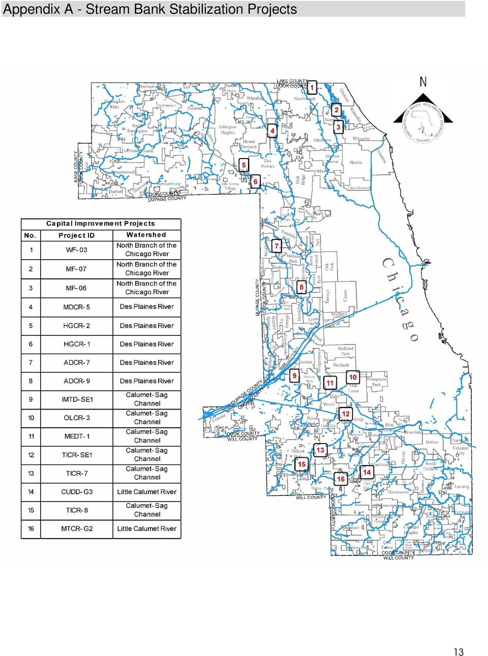
4 Stormwater Management Activities Stormwater Management Capital Improvement Program Capital improvement projects recommended for implementation by DWPs are separated into two categories: streambank stabilization and flood control. Projects given the highest priority for implementation are streambank stabilization projects which address streambank erosion posing an imminent threat to public safety and/or structures. Flood control projects will address regional flooding issues through traditional measures, such as stormwater detention reservoirs, levees, and conveyance improvements. Preliminary engineering and design of projects approved by the Board of Commissioners are underway and will continue into the future. Streambank Stabilization Projects The following is a detailed list of streambank stabilization projects. Streambank stabilization project locations are shown in Appendix A. TICR-8 (Tinley Creek) Location: Orland Park Description: Stabilize approximately 1,803 LF of Tinley Creek using a combination of retaining walls and bioengineering techniques. Estimated Construction Cost: $2,460,000 TICR-7 (Tinley Creek) Watershed: Calumet-Sag Channel Location: Orland Park Description: Stabilize approximately 2,200 LF of Tinley Creek using a combination of retaining walls and bioengineering techniques. Estimated Construction Cost: $3,410,000 OLCR-3 (Oak Lawn Creek) Watershed: Calumet-Sag Channel Location: Oak Lawn Description: Stabilize approximately 1,070 LF of Oak Lawn Creek using concrete walls. Estimated Construction Cost: $3,130,000 CUDD-G3 (Calumet Union Drainage Ditch) Watershed: Little Calumet River Location: Markham Description: Stabilize approximately 3,559 LF of Calumet Union Drainage Ditch using bioengineering techniques and provide conveyance improvements. Estimated Construction Cost: $2,970,000 MTCR-G2 (Midlothian Creek) Watershed: Little Calumet River Location: Tinley Park Description: DWP recommended to stabilize Midlothian Creek at two locations: between 172 nd Street and Oak Park Avenue and between Hickory Street and 66 th Court. Estimated Construction Cost: $190,000 Status: Preliminary Engineering 4

5 MEDT-1 (Melvina Ditch) Watershed: Calumet-Sag Channel Location: Chicago Ridge, Oak Lawn Description: Stabilize approximately 2,700 LF of Melvina Ditch. Conceptual Cost Estimate: $2,845,500 Status: Preliminary Engineering TICR-SE1 (Tinley Creek) Watershed: Calumet-Sag Channel Location: Crestwood Description: Stabilize approximately 1,000 LF of Tinley Creek using gabions. Estimated Construction Cost: $1,213,320 IMTD-SE1 (I&M Canal Tributary D) Watershed: Calumet-Sag Channel Location: Willow Springs Description: Stabilize approximately 1,250 LF of I&M Canal Tributary D using a combination of gabions and riprap. Estimated Construction Cost: $361,643 MF-06 (Middle Fork of the North Branch of the Chicago River) Watershed: North Branch of the Chicago River Location: Northfield Description: Stabilize approximately 1,730 LF along the Middle Fork of the North Branch of the Chicago River. Conceptual Cost Estimate: $1,610,000 Status: Design MF-07 (Middle Fork of the North Branch of the Chicago River) Location: Northfield Watershed: North Branch of the Chicago River Description: Stabilize approximately 1,205 LF along the Middle Fork of the North Branch of the Chicago River. Conceptual Cost Estimate: $971,000 Status: Design WF-03 (West Fork of the North Branch of the Chicago River) Watershed: North Branch of the Chicago River Location: Northbrook Description: Stabilize approximately 1,420 LF along the West Fork of the North Branch of the Chicago River. Conceptual Cost Estimate: $2,022,000 Status: Design ADCR-9 (Addison Creek) Location: North Riverside Description: Stabilize approximately 580 LF along Addison Creek. Conceptual Cost Estimate: $219,000 Status: Design 5
 Watershed: Calumet-Sag Channel Location: Willow Springs Description: Stabilize approximately 1,250 LF of I&M Canal Tributary D")
6 ADCR-7 (Addison Creek) Location: Northlake Description: Stabilize approximately 1,010 LF along Addison Creek. Conceptual Cost Estimate: $809,000 Status: Design HGCR-1 (Higgins Creek) Location: Des Plaines Description: Stabilize approximately 210 LF along Higgins Creek. Conceptual Cost Estimate: $763,000 Status: Design MDCR-5 (McDonald Creek) Location: Mount Prospect Description: Stabilize approximately 150 LF along McDonald Creek. Conceptual Cost Estimate: $798,000 Status: Design HGCR-2 (Higgins Creek) Location: Unincorporated Elk Grove Township Description: Stabilize approximately 400 LF along Higgins Creek. Conceptual Cost Estimate: $1,375,293 Approved for Design on August 11, 2011 Status: Design Flood Control Projects The following is a detailed list of flood control projects. Flood control project locations are shown in Appendix B. CHEB-G3 (Cherry Creek) Watershed: Little Calumet River Location: Homewood Description: Construct 900 LF of new open channel on the west side of Governors Highway, create a flood shelf in the existing channel, and add culverts. Estimated Construction Cost: $3,017,900 TICR-5 (Tinley Creek) Watershed: Calumet-Sag Channel Location: Orland Hills, Orland Park Description: Dredge 1,500 LF of Tinley Creek downstream of Lake Lorin and remove existing low flow pipe. Estimated Construction Cost: $172,900 SCAH-50 (Upper Salt Creek) Watershed: Upper Salt Creek Location: Palatine Description: Construct 1,200 LF of conveyance improvements. Estimated Construction Cost: $962,000 6
 Location: Unincorporated Elk Grove Township Description: Stabilize approximately 400 LF along Higgins Creek.")
7 TICR-3 (Tinley Creek) Watershed: Calumet-Sag Channel Location: Alsip, Crestwood, and Unincorporated Cook County Description: Increase conveyance capacity along 2,000 LF of Tinley Creek. Estimated Construction Cost: $2,572,800 NVCR-3 (Navajo Creek) Watershed: Calumet-Sag Channel Location: Palos Heights Description: Raise bike trail 3 ft to provide additional storage in Lake Arrowhead. Estimated Construction Cost: $589,200 DRCR-G1 (Deer Creek) Watershed: Little Calumet River Location: Ford Heights Description: Increase channel conveyance and raise berm for 3,000 LF. Estimated Construction Cost: $4,644,000 FGTB-1 (Flagg Creek Tributary B) Location: Burr Ridge, Lyons Township Description: Construct channel improvements, new outfall and provide mitigation storage. Conceptual Cost Estimate: $816,000 Status: Preliminary Engineering ADCR-6B (Addison Creek) Location: Northlake, Stone Park, Melrose Park, Bellwood, and Westchester Description: Construct a 960 ac-ft reservoir and conveyance improvements. Conceptual Cost Estimate: $133,921,000 Status: Preliminary Engineering DPR-13 (Des Plaines River) Location: Riverside and Riverside Township Description: Construct a 4,300 LF floodwall. Conceptual Cost Estimate: $14,481,000 Status: Preliminary Engineering BUCR-1B (Buffalo Creek) Location: Buffalo Grove and Wheeling Description: Construct conveyance improvements and partial bulk-head to provide flood storage. Conceptual Cost Estimate: $613,000 Status: Preliminary Engineering MS-10 (Main Stem of the North Branch of the Chicago River) Watershed: North Branch of the Chicago River Location: Chicago (Albany Park) Description: Construct a floodwall. Conceptual Cost Estimate: $16,402,000 Status: Approved for Preliminary Engineering 7
 Location: Burr Ridge, Lyons Township Description: Construct channel improvements, new outfall and provide mitigation storage.")
8 SR-08 (Skokie River) Watershed: North Branch of the Chicago River Location: Northfield Description: Construct a levee on both sides of Interstate 94. Conceptual Cost Estimate: $5,761,000 Status: Approved for Preliminary Engineering WF-06 (West Fork of the North Branch of the Chicago River) Watershed: North Branch of the Chicago River Location: Northbrook, Glenview, Golf, and Unincorporated Cook County Description: Construct an additional 1,100 ac-ft of storage to expand Techny Reservoir 32A. Conceptual Cost Estimate: $116,088,000 Status: Preliminary Engineering FRCR-12(Farmers Prairie Creek). Location: Park Ridge, Des Plaines, Niles, and Maine Township Description: Construct conveyance improvements, pump station, additional storage, and a new force main. Conceptual Cost Estimate: $19,788,000 Status: Preliminary Engineering Heritage Park Flood Control Facility While the DWPs were being developed, the MWRD considered funding projects that would provide regional benefits as identified in studies performed by regional agencies such as the Illinois Department of Natural Resources/Office of Water Resources (IDNR-OWR) and the United States Army Corps of Engineers (USACE). One such project is the Heritage Park Flood Control Facility, which will provide the required compensatory storage for USACE s Levee 37 project along the Des Plaines River. In 1999, the USACE approved a study for the Upper Des Plaines River from the Wisconsin/Illinois state line to Riverside, Illinois. Known as the Des Plaines River Phase I Study, its purpose is to identify solutions to flooding along the main stem of the river. Subsequently, the MWRD began negotiations with the Wheeling Park District and the Village of Wheeling for the use of Heritage Park in Wheeling as the site of the compensatory storage required for Levee 37. The MWRD entered into an intergovernmental agreement with the Wheeling Park District and the Village of Wheeling on April 1, 2010, and final design of the Heritage Park Flood Control Facility commenced shortly thereafter. Final design was completed in 2011, and a construction contract was awarded in 2012 for $29.5 million. Construction is currently underway and is anticipated to be completed in The project includes an expansion to the existing stormwater detention reservoir known as Lake Heritage, excavation of new floodwater storage areas east and west of Buffalo Creek, and passive and active recreation components. An exhibit depicting the Heritage Park Flood Control Facility is provided in Appendix C. Small Streams Maintenance Program (SSMP) The 2012 Small Streams Maintenance Program (SSMP) successfully concluded the sixth full year of operation. This program, conceived and established in 2006, follows the MWRD s stormwater management mission to relieve flooding in urbanized areas through immediate and relatively simple remedies. The objective of the program is to remove obstructions and debris in the waterways that impede the natural drainage of Cook County s small streams and rivers with the potential for flooding urban areas. 8
.")
9 In November 2012, the MWRD awarded a new two-year stream maintenance contract. The MWRD paid a total of $1,855, in 2012 to contractors to provide stream maintenance. The SSMP is advertised on the MWRD s website and includes a link to allow citizens to report stream blockages. Throughout the year, the SSMP staff attended Watershed Planning Councils (WPCs) meetings, Councils of Governments (COGs) meetings, and local public works meetings to provide an overview of the program s purpose, objectives, and goals. The local municipalities enthusiastically assisted in identifying blockages, stream deficiencies, and sensitive areas within their jurisdictions. Their communication with the MWRD is ongoing and valuable to the success of the program. MWRD staff also contacted representatives of the various WPCs and COGs, along with contacting local public works officials and citizens directly to coordinate the work. MWRD staff and contractor crews removed approximately 23,392 cubic yards of debris in Included in the debris total was 2,917 cubic yards of river and canal debris removed by the MWRD s debris and pontoon boat crews along the Chicago Area Waterways (CAWS). Listed in the table below are the amounts removed in each watershed. Watershed 2010 Cubic Yards Removed 2011 Cubic Yards Removed 2012 Cubic Yards Removed Little Cal 6,472 9,526 5,564 Cal Sag 9,489 3,195 7,414 Lower Des Plaines 10,832 12,874 5,310 North Branch 4,692 4,338 4,313 Upper Salt Creek 1, Poplar Creek 1, Total 34,721 30,762 23,392 In 2012, local municipalities provided valuable assistance in debris removal by providing barricades, flagmen, trucks, various equipment, road control, and debris disposal of approximately 2,028 cubic yards, saving the MWRD approximately $48,000. The SSMP will continue in 2013 at a contract budget value of $2,500,000. It is anticipated that 35,000 cubic yards of debris will be removed from streams and rivers in Major goals include standardizing procedures, identifying critical stream areas, scheduling critical inspections, and continuing to introduce the MWRD s Small Stream crews to local governments to increase the public s awareness of the MWRD s presence and execution of the SSMP. The total 2012 expenditure for the SSMP program was $3,354,567. Therefore, the average cost per cubic yard was $ Watershed Management Ordinance The goal of the Watershed Management Ordinance (WMO) is to establish uniform, minimum, countywide stormwater management regulations throughout Cook County. Components which may be regulated under the WMO include drainage and detention, floodplain management, wetland protection, stream habitat, and riparian environment protection, soil erosion and 9

10 sediment control, and water quality. A draft WMO was released for public comment in 2009 and six public hearings were conducted throughout Cook County. At the request of various Cook County Municipalities and stakeholders, the MWRD conducted an Economic Impact Study (EIS) of the draft WMO. The purpose of the EIS was to estimate the economic effect the draft WMO may have on real estate development in Cook County. The MWRD conducted the EIS in two components: an engineering analysis and a real estate economic impact analysis. The MWRD concluded the EIS in November of Final reports for both the engineering analysis and real estate economic impact analysis are accessible through The MWRD intends to publish an updated draft WMO for public review and comment in the second quarter of Shortly thereafter, the MWRD intends to present the draft WMO to its Board of Commissioners for consideration and adoption. Joint Funding Agreement with the United States Geological Survey (USGS) for Stream Gaging Stations in Cook County The MWRD entered into a Joint Funding Agreement with the USGS in 2006 and has renewed the agreement annually to fund the maintenance and operation of the following eight stream gages located within Cook County: 1. North Branch of the Chicago River at Deerfield 2. Salt Creek at Elk Grove Village 3. Salt Creek at Western Springs 4. Salt Creek at Rolling Meadows 5. Deer Creek near Chicago Heights 6. Butterfield Creek at Flossmoor 7. Midlothian Creek at Oak Forest 8. Tinley Creek near Palos Park The data from the streamflow gaging stations has proven useful for the MWRD with calibration of the hydrologic and hydraulic models in the DWP development. In addition to the streamflow gages, this agreement also funds a rain gage on Salt Creek near Rolling Meadows. Real time data from these gages is available on the USGS s website at A map showing the location of the gages is presented in Appendix D. Coordination with Watershed Planning Councils (WPCs) The Act required the formation of WPCs, which serve as advisory bodies to the MWRD for its stormwater management program. Membership in the WPCs includes the chief elected official, or his or her designee, for municipalities and townships, and the Cook County Board President, or his or her designee, for unincorporated areas. In 2005, the municipal conferences, with assistance from the MWRD, established WPCs for the watersheds of the North Branch of the Chicago River, the Lower Des Plaines River, the Calumet-Sag Channel, the Little Calumet River, Poplar Creek, and Upper Salt Creek. Since 2005, each of the WPCs has met at least quarterly, as required by the Act. WPC meetings serve as a mechanism for representatives of municipalities and townships to be updated on the progress of the DWPs, SSMP, WMO, and capital projects, as well as to communicate concerns of the public to the MWRD. The following Councils of Government (COGs) are responsible for coordination of the WPCs: Northwest Municipal Conference, West Central Municipal Conference, South Suburban Mayors and Managers Association, and Southwest Conference of Mayors. The MWRD negotiated 10

11 agreements with each of the COGs to provide administrative assistance related to coordination of the WPCs; the current agreement was renewed for 2012 and In 2012, the COGs assisted the MWRD by arranging meeting schedules, drafting and distributing meeting agendas, distributing information from the MWRD to WPC members, assembling contact information for WPC representatives, and forwarding information about stormwater management concerns from the WPC members to the MWRD. Rain Barrel Program The MWRD introduced a Rain Barrel Program in 2007 and continued to sell rain barrels and distribute them on a monthly basis at the Stickney Water Reclamation Plant (WRP), Calumet WRP, Egan WRP and North Side WRP in 2012, and for the first time, included home delivery. The cost for a rain barrel was $58. Individuals are able to order up to two rain barrels per household each year. Municipalities within the MWRD boundaries are also able to purchase up to 40 rain barrels, which are then sold to their residents. As a result of an advertising campaign, the MWRD sold 707 rain barrels in The rain barrel program will continue in 2013, and the MWRD is anticipating an increase in sales to approximately 1,000. Public Affairs In 2012, MWRD staff provided information about the Stormwater Management Program at various public events in communities throughout the region and at various technical conferences. The MWRD attends all WPC meetings to provide updates on watershed planning efforts, development of the WMO, and stream maintenance activities. These meetings are open to the public and provide an opportunity for concerns of the public to be communicated to the MWRD. The MWRD also produced a SSMP newsletter, "Small Streams, Big Accomplishments", which was made available at WPC meetings and was posted on the MWRD s website. The MWRD also organized press conferences related the Heritage Park Flood Control Project and worked to educate the general public on their water footprint by attending 47 community and environmental fairs. The 2012 Stormwater Management related press releases are listed in Appendix F. MWRD Staff will continue to participate in community outreach events and provide rain barrel giveaways through the Water Environment Pledge initiative in The MWRD will continue to participate in Watershed Planning Council meetings, create the "Small Streams, Big Accomplishments newsletter and continue to promote the MWRD stormwater management efforts using press releases and other media outlets. 11
, Calumet")
12 Appendices Appendix A Appendix B Appendix C Appendix D Appendix E Appendix F Streambank Stabilization Projects Flood Control Projects Heritage Park Flood Control Facility MWRD and USGS Joint Funded Stream Gages Stormwater Expenditures Stormwater Management Related Press Releases 12

13 Appendix A - Stream Bank Stabilization Projects 13
14 Appendix B - Flood Control Projects 14

15 Appendix C - Heritage Flood Control Facility 15

16 Appendix D - MWRD and USGS Joint Funded Stream Gages 16

17 Appendix E - Expenditures Category Description 2012 Personal Services: Consultant Personal Services: In-House Contractual Services Administrative Expenses Expenditures Fees paid to consultants for professional services rendered, including the following projects: $ 5,418,850 Preliminary and Final Engineering $ 5,033,554 Post Award $ 315,616 Heritage Park Flood Control Facility Final Design $ 31,745 Heritage Park Flood Control Facility Legal Services $ 12,435 SSMP GIS Implementation $ 25,500 Salaries and associated costs related to MWRD personnel: $ 4,408,073 Engineering Department $ 1,527,200 Maintenance and Operations Department $ 2,880,873 Fees paid for services provided by COGs, agencies or companies, including the following: COGs Administrative Contracts: $ $ 6,938,800 Northwest Municipal Conference $ 4,855 South Suburban Mayors and Managers Association $ 4,240 Southwest Conference of Mayors $ 13,924 West Central Municipal Conference $ 11,040 Small Streams Maintenance Program $ 1,855,978 Small Streams Maintenance Program Waste Disposal $ 51,252 Court Reporting Services $ 8,835 USGS Joint Funding Agreement for Stream Gaging Stations in Cook County $ 70,985 Streetscape and Sustainability Design Program $ 60,000 Heritage Park Flood Control Facility Land Acquisition $ 84,851 Waterways Facilities Structures $ 4,545,436 Repairs to Collection Facilities $ 183,848 Miscellaneous Contractual Services $ 43,556 Materials, equipment and supplies: $ 15,791 Total 2012 Expenditures $ 16,781,514 17

18 Appendix F Stormwater Management Related Press Release April 16 April 17 May 8 MWRD and Gompers Fine Art Option students to celebrate Earth month by painting rain barrels Rain barrels draw attention to water collection during Earth Week; MWRD, Shedd Aquarium and Gompers School use artistic flair Roll out the (rain) barrel! MWRD announces newly improved rain barrel sales program May 31 Heritage Park stormwater facility groundbreaking set for June 4 June 6 June 6 June 20 June 21 July 2 August 29 October 11 October 16 October 16 October 23 November 1 November 26 November 28 MWRD, federal, state and local officials break ground on flood control facility Irish American Heritage Center, Shamrock Kids Club paint rain barrels, plant seeds to promote conservation Buffalo Grove to host first environmental green fair; MWRD to give away a rain barrel MWRD to give away a rain barrel at the Green Music Fest in Wicker Park Act now to prevent basement backups later; Limit use of water prior to and during storms Free delivery improves residents access to rain barrels in Cook County; Drought season increases need MWRD Commissioner Debra Shore helps unveil Greenest street in America MWRD Commissioner Mariyana Spyropoulos explains flood prevention methods during environmental panel MWRD s David St. Pierre invited to participate on national stormwater management panel at White House U.S. Senator Durbin, officials inspect Heritage Park Flood Control Facility construction site Governor Pat Quinn, partners announce completion of Hofmann Dam removal on Des Plaines River Riverbank Neighbors, environmental groups and MWRD discuss streambank improvements for north branch of Chicago River Small Streams, Big Accomplishments newsletter highlights efforts to keep waterways clear and prevent flooding 18

CHAPTER 65. METROPOLITAN WATER RECLAMATION DISTRICT OF GREATER CHICAGO ANNEX
 CHAPTER 65. METROPOLITAN WATER RECLAMATION DISTRICT OF GREATER CHICAGO ANNEX 65.1 HAZARD MITIGATION PLAN POINT OF CONTACT Primary Point of Contact Michael Cosme, Senior Civil Engineer Engineering Department,
Upper Des Plaines River & Tributaries, IL & WI Feasibility Study
 Upper Des Plaines River & Tributaries, IL & WI Feasibility Study Jeffrey Zuercher Project Manager Chicago District February 19, 2014 Study Partnership: US Army Corps of Engineers Agenda Background Study
Cook County Stormwater Management Plan
 Appendix A Questionnaire Drainage District Responses A stormwater management questionnaire was developed by the Metropolitan Water Reclamation District of Greater Chicago to assess the current stormwater
Appendix A. Lists of Accomplishments and Project Costs. UMRWD 10 Year Plan Update. Appendix A UPPER MINNESOTA RIVER WATERSHED DISTRICT
 UPPER MINNESOTA RIVER WATERSHED DISTRICT Lists of Accomplishments and Project Costs 10 Year Plan Update UMRWD 10 Year Plan Update Page A 1 UMRWD LIST OF ACCOMPLISHMENTS Since its inception in 1967, the
Clerk Orr releases 2012 Tax Rates
 Courtney Greve 312.603.0931 312.502.3267 courtney.greve@cookcountyil.gov For Immediate Release: June 25, 2013 Clerk Orr releases 2012 Tax Rates Cook County Clerk David Orr s office on Tuesday released
CITY OF HIGHLAND PARK, ILLINOIS Stormwater Management Fact Sheet
 CITY OF HIGHLAND PARK, ILLINOIS Stormwater Management Fact Sheet WHAT IS STORMWATER MANAGEMENT? Stormwater management is the method for channeling rainfall through pipes and sewers away from property to
Lower Raritan Watershed Management Area Stormwater & Flooding Subcommittee Strategy Worksheet LRSW-S3C1
 Strategy Name: Reduce Existing Potential for Flood Damages LRSW-S3C1. Develop and implement a program to: Minimize flood damages through the use of structural measures. Minimize flood damages through the
The Basics of Chapter 105 Waterways and Wetlands Permitting in PA
 The Basics of Chapter 105 Waterways and Wetlands Permitting in PA April 17, 2013 Goal To develop a basic understanding of PA Department of Environmental Protection (DEP) and US Army Corps of Engineers
Flood Risk Management
 Flood Risk Management Value of Flood Risk Management Every year floods sweep through communities across the United States taking lives, destroying property, shutting down businesses, harming the environment
Flood Risk Management
 Flood Risk Management Value of Flood Risk Management Value to Individuals and Communities Every year floods sweep through communities across the United States taking lives, destroying property, shutting
2012 Program Report. Agricultural Group Drainage Program
 2012 Program Report Agricultural Group Drainage Program Accomplishments: It was a successful year for the drainage program. We were able to complete two new projects and seven maintenance projects throughout
Living on the Fox River
 This information could save you money! Living on the Fox River A Riverfront Property Owners Guide This brochure was developed by Fox River Ecosystem Partnership in cooperation with the Kane-DuPage Soil
Harris County Flood Control District. Policy, Criteria, and Procedure Manual
 Harris County Flood Control District Policy, Criteria, and Procedure Manual For Approval and Acceptance of Infrastructure General Review October 10, 2003 Draft Please Provide Written Comments to the HCFCD
Chapter 4. Flood Control
 Chapter 4. Flood Control As noted by their name, flood control measures control floodwaters and keep them from reaching damageable property. They are also called structural measures because they involve
Prattsville Berm Removal Project. 1.0 Project Location
 Prattsville Berm Removal Project 1.0 Project Location The project site is located between the New York State Route 23 Bridge over the Schoharie Creek and the Schoharie Reservoir. The restoration plan encompassed
Understanding Your An Introduction to the Chicago Area s Combined Sewer Systems
 Understanding Your An Introduction to the Chicago Area s Combined Sewer Systems Metropolitan Water Reclamation District of Greater Chicago What is a combined sewer? In a combined sewer system, sanitary
DELAWARE COUNTY STREAM CORRIDOR MANAGEMENT PROGRAM TWO-YEAR ACTION PLAN FOR THE WEST BRANCH DELAWARE RIVER CANNONSVILLE RESERVOIR BASIN
 DELAWARE COUNTY STREAM CORRIDOR MANAGEMENT PROGRAM TWO-YEAR ACTION PLAN FOR THE WEST BRANCH DELAWARE RIVER CANNONSVILLE RESERVOIR BASIN May 2011 - April 2013 1. Introduction 2. Recommendations Table of
Lower Crooked Creek Watershed Conservation Plan EXECUTIVE SUMMARY
 EXECUTIVE SUMMARY Project Background Located in southwestern Pennsylvania, Crooked Creek is a major tributary of the Allegheny River, entering near Ford City in Armstrong County. It is rich in natural
Swannanoa River Flood Risk Management Study
 Swannanoa River Flood Risk Management Study Measures Evaluated to Reduce Future Flood Damages City of Asheville U.S. Army Corps of Engineers Flooding History Part of the 132 square mile Swannanoa River
Post-Flood Assessment
 Page 1 of 7 Post-Flood Assessment CHAPTER 4 AGENCY COORDINATION Agency coordination is an essential element for the operation of the flood management systems in the Central Valley. Due to the nature of
5.0 OVERVIEW OF FLOOD DAMAGE REDUCTION MEASURES
 5.0 OVERVIEW OF FLOOD DAMAGE REDUCTION MEASURES Flood damage reduction consists of two basic techniques structural and non-structural. Structural methods modify the flood and take the flood away from people
FARMERS V. RECLAMATION DISTRICT-ORIGINAL COMPLAINT-140416-P 1
 ~ IN THE CIRCUIT COURT OF COOK COUNTY, ILLINOIS COUNTY DEPARTMENT, CHANCERY DIVISION Illinois Fanners Insurance Company and Fanners Insurance Exchange, and all subsidiaries and/or related entities oflllinois
North Branch Chicago River Watershed-Based Plan
 North Branch Chicago River Watershed-Based Plan EXECUTIVE SUMMARY In Lake County, the Lake County Stormwater Management Commission (SMC) is responsible for managing Lake County s water resources. The North
LEAGUE NOTES ON APPROVED COMMUNITY WATER SUPPLY PLAN
 1 AUGUST 2011 LEAGUE NOTES ON APPROVED COMMUNITY WATER SUPPLY PLAN KEY ELEMENTS OF THE PLAN: 1. Replace the existing unsafe Ragged Mountain dam with a new dam and raise the reservoir pool level initially
INTRODUCTION FIGURE 1 BIGHEAD CARP
 REBUILDING CHICAGO S STORMWATER AND WASTEWATER SYSTEMS FOR THE 21ST CENTURY: UNDERSTANDING HYDROLOGIC CONDITIONS IN THE REGION TECHNICAL REPORT, OCTOBER, 2010 Table of Contents INTRODUCTION... 2 DATA SOURCES
Sims Bayou Federal Flood Damage Reduction Project
 Sims Bayou Federal Flood Damage Reduction Project A. Gene Rushing, Jr., P.E., PMP HCFCD Project Manager January 15, 2014 Harris County s Watersheds Historical Flooding in Harris County 1929 1935 HCFCD
 Coldwater Heritage Partnership Implementation Grant Final Report Morrison Run Watershed Restoration Project Western Pennsylvania Conservancy Project Summary The goal of the Morrison Run Watershed Restoration
HCP Team Meeting. November 18, 2015. icfi.com
 HCP Team Meeting November 18, 2015 icfi.com 1 Welcome and Introductions Where are we in the HCP process Hydrology modeling update Native fish survey Fish translocation Finalize covered activities Next
Maryland 1. Dependent Public School Systems (39) Maryland ranks 46th among the states in number of local governments, with 265 as of June 2002.
 Maryland ranks 46th among the states in number of local governments, with 265 as of June 2002.") Maryland Maryland ranks 46th among the states in number of local governments, with 265 as of June 2002. COUNTY GOVERNMENTS (23) The entire state is encompassed by county government with the exception of
Maryland Maryland ranks 46th among the states in number of local governments, with 265 as of June 2002. COUNTY GOVERNMENTS (23) The entire state is encompassed by county government with the exception of
5.14 Floodplains and Drainage/Hydrology
 I-70 East Final EIS 5.14 Floodplains and Drainage/Hydrology 5.14 Floodplains and Drainage/Hydrology This section discusses floodplain and drainage/hydrology resources and explains why they are important
Chehalis River Basin Flood Damage Reduction 2013-2015 Capital Budget Approved by Legislature in June 2013
 Chehalis River Basin Flood Damage Reduction 2013-2015 Capital Budget Approved by Legislature in June 2013 1. Design alternatives for large capital flood projects (basinlevel water retention and Interstate
Citizens Guide to Property Tax Bills
 Citizens Guide to Property Tax Bills 1 B R I D G E T G A I N E R C O O K C O U N T Y C O M M I S S I O N E R, 1 0 TH D I S T R I C T T E L E P H O N E : ( 3 1 2 ) 6 0 3-4 2 1 0 W E B S I T E : W W W. B
ESCAMBIA COUNTY FLOOD RECOVERY: 1- YEAR ANNIVERSARY REPORT
 Joy D. Blackmon, P.E. Director, County Engineer Public Works Department ESCAMBIA COUNTY FLOOD RECOVERY: 1- YEAR ANNIVERSARY REPORT EXECUTIVE SUMMARY One year after the devastating April 2014 floods hit
5. Environmental Analysis
 5.11 The potential for adverse impacts on utilities and service systems was evaluated based on information concerning current service levels and the ability of the service providers to accommodate the
QUESTIONS AND ANSWERS WATERS OF THE U.S. PROPOSAL
 QUESTIONS AND ANSWERS WATERS OF THE U.S. PROPOSAL Key Background Congress enacted the modern Clean Water Act in 1972 to address pollution entering the nation s waters to complement statutes such as the
administrative subdivisions of the counties and are not counted as separate governments in census statistics on governments. IOWA
 IOWA Iowa ranks 17th among the states in number of local governments with 1,954 as of October 2007. COUNTY GOVERNMENTS (99) There are no areas in Iowa lacking county government. The county governing body
Flood Plain Reclamation to Enhance Resiliency Conserving Land in Urban New Jersey
 Flood Plain Reclamation to Enhance Resiliency Conserving Land in Urban New Jersey Rutgers Cooperative Extension Water Resources Program Christopher C. Obropta, Ph.D., P.E. Email: obropta@envsci.rutgers.edu
Community RiskMAP Questionnaire
 Community RiskMAP Questionnaire Please provide the following information County Date: Community Name/Organization: Your Your E-mail: Contact Preference: E-mail Phone Mail The Federal Emergency Management
US Army Corps of Engineers BUILDING STRONG
 Fort Worth District Public Meeting 20 August 2013 US Army Corps of Engineers Lewisville Dam - Authorization Authorized by the River and Harbor Act, approved 2 March 1945 (Public Law 14, 79th Congress,
Lockport Pool Chicago Sanitary & Ship Canal Illinois Waterway
 Presentation to the Inland Waterways Users Board Lockport Pool Chicago Sanitary & Ship Canal Illinois Waterway by Gary Loss, P.E. Rock Island District July 13, 2006 Chicago Sanitary and Ship Canal A
COMBINED SEWER OVERFLOW OPERATIONAL AND MAINTENANCE PLAN SUMMARY
 COMBINED SEWER OVERFLOW OPERATIONAL AND MAINTENANCE PLAN SUMMARY Revised: April 2014 Village of Wilmette, Illinois NPDES CSO Permit No. ILM580012 Chapter 1 Introduction This Operational and Maintenance
The City of Ottawa Flood Hazards
 The City of Ottawa Flood Hazards The City of Ottawa is located in North Central LaSalle County, approximately 45 miles West of Joliet and 90 miles South of Rockford. The primary water course and sources
BINGHAMTON FLOOD DAMAGE REDUCTION PROJECT
 BINGHAMTON FLOOD DAMAGE REDUCTION PROJECT Department of Environmental Conservation Region 7 Counties: Broome, Cayuga, Chenango, Cortland, Madison, Onondaga, Oswego, Tioga, Tompkins Operated and Maintained
How the Chicago District, US Army Corps of Engineers Conducts Project Management 20 November 2013
 How the Chicago District, US Army Corps of Engineers Conducts Project Management 20 November 2013 Lieutenant Colonel Kevin Lovell Deputy Commander Chicago District US Army Corps of Engineers US Army Corps
Final Report. Dixie Creek Restoration Project. Funded by Plumas Watershed Forum
 Final Report Dixie Creek Restoration Project Funded by Plumas Watershed Forum Plumas Corporation January 2009 1 Background FR-CRM staff presented this project to the Dixie Valley Landowners Association
BLACK/HARMONY/FAREWELL CREEK WATERSHED EXISTING CONDITIONS REPORT CHAPTER 12 - STORMWATER MANAGEMENT
 Harmony Creek subwatershed Harmony Creek subwatershed BLACK/HARMONY/FAREWELL CREEK WATERSHED EXISTING CONDITIONS REPORT CHAPTER 12 - STORMWATER MANAGEMENT April 2011 TABLE OF CONTENTS 1.0 INTRODUCTION...
4. Environmental Impacts Assessment and Remediation Targets
 4. Environmental Impacts Assessment and Remediation Targets 4.1 Environmental Impacts Significant additional development in the Alder Creek watershed is not anticipated at this time; however, there are
7.0 Stream Restoration
 7.0 Stream Restoration 7.1 Issue Statements One of the primary concerns of residents in the Bassett Creek watershed is the maintenance of the natural beauty of the creek in residential and recreational
Stormwater Management in Chicago waterways :Basement Flooding and its prevention Kyungmin Kim
 Stormwater Management in Chicago waterways :Basement Flooding and its prevention Kyungmin Kim CE 394K GIS in Water Resources - David R. Maidment. Dec 4th 2015 Motivation and Objective Recently, Chicago
Why does Kittitas County want to form a Flood Control Zone District?
 KITTITAS COUNTY DEPARTMENT OF PUBLIC WORKS Kirk Holmes, Director What is a Flood Control Zone District (FCZD)? A Kittitas County Flood Control Zone District (FCZD) would be a special-purpose government
1.7.0 Floodplain Modification Criteria
 1.7.0 Floodplain Modification Criteria 1.7.1 Introduction These guidelines set out standards for evaluating and processing proposed modifications of the 100- year floodplain with the following objectives:
Iowa Smart Planning. Legislative Guide March 2011
 Iowa Smart Planning Legislative Guide March 2011 Rebuild Iowa Office Wallace State Office Building 529 East 9 th St Des Moines, IA 50319 515-242-5004 www.rio.iowa.gov Iowa Smart Planning Legislation The
County of Cook, Illinois
 County of Cook, Illinois ACTION PLAN DRAFT FOR PUBLIC REVIEW/COMMENT CDBG Disaster Recovery Grant Toni Preckwinkle, President Cook County Board of Commissioners Prepared by: The Department of Planning
Community Workshop 5. Overarching Goals for Machado Lake Ecosystem and Wilmington Drain Multi-Use Projects
 City of Los Angeles Department of Public Works Bureau of Engineering Machado Lake Ecosystem Rehabilitation Project & Wilmington Drain Multi-Use Project Community Workshop 5 February 24, 2009 In association
Shooks Run Drainage Study Basic Terminology
 Shooks Run Drainage Study Basic Terminology PREPARED FOR: PREPARED BY: City of Colorado Springs CH2M DATE: April 9, 2015 Introduction This document is intended to provide an introduction to Colorado Springs
Tobique Employment & Training
 APPENDICES 3 Tobique Employment & Training Flood Mitigation July 30, 2012 Overview This proposal outlines the work required and budget for flood mitigation measures on Tobique First Nation which is required
MEETING DATE: February 08, 2008
 Truckee River Flood Management Project FLOOD PROJECT COORDINATING COMMITTEE STAFF REPORT MEETING DATE: February 08, 2008 DATE: February 1, 2008 TO: Flood Project Coordinating Committee Members FROM: Naomi
Agenda Item Executive Summary
 Agenda Item Executive Summary Title: Willow Road STADI Project Engineering: Change Order #2: Initial Permit Submittals Presenter: Steven M. Saunders, Director of Public Works/Village Engineer Agenda Date:
St. Vrain Watershed Master Plan Thursday, January 23 10:00 a.m. 12:15 p.m.
 St. Vrain Watershed Master Plan Thursday, January 23 10:00 a.m. 12:15 p.m. City Council Study Session Room City of Longmont Civic Center, 350 Kimbark Street, Longmont Minutes 1. Introductions a. Jeff Crane
March 2008. Prepared by: Irvine Ranch Water District. 15600 Sand Canyon Avenue. Irvine, CA 92618. Contact: Natalie Likens (949) 453-5633
 453-5633") ADDENDUM TO THE MICHELSON WATER RECLAMATION PLANT PHASE 2 & 3 CAPACITY EXPANSION PROJECT FEBRUARY 2006 FINAL ENVIRONMENTAL IMPACT REPORT AND THE SAN JOAQUIN FRESHWATER MARSH ENHANCEMENT PLAN REVISED SEPTEMBER
ADDENDUM TO THE MICHELSON WATER RECLAMATION PLANT PHASE 2 & 3 CAPACITY EXPANSION PROJECT FEBRUARY 2006 FINAL ENVIRONMENTAL IMPACT REPORT AND THE SAN JOAQUIN FRESHWATER MARSH ENHANCEMENT PLAN REVISED SEPTEMBER
Chagrin River Watershed Partners, Inc. Cost Analysis of Low Impact Development Best Management Practices
 Chagrin River Watershed Partners, Inc. Cost Analysis of Low Impact Development Best Management Practices Amy H. Brennan (440) 975-3870 www.crwp.org abrennan@crwp.org Chagrin River Watershed Partners Formed
12/3/2015 MUNICIPAL STORMWATER RESPONSIBILITIES YOU NEED TO KNOW WHAT IS STORMWATER? WHY?
 MUNICIPAL STORMWATER RESPONSIBILITIES YOU NEED TO KNOW WHAT IS STORMWATER? Stormwater occurs when precipitation from rain or snowmelt flows over the ground WHY? 1 DEP/EPA AUDITING It is happening! Here
MassDEP Natural Disaster Guidance for Coastal and Inland Wetland Resource Area Impacts: Hurricane or Tropical Storm Sandy
 MassDEP Natural Disaster Guidance for Coastal and Inland Wetland Resource Area Impacts: Hurricane or Tropical Storm Sandy Tropical Storm Sandy may cause severe flooding, erosion and other impacts to wetland
Greater Los Angeles County Region
 Attachment 6 Greater Los Angeles County Region IRWM Implementation Grant Proposal Monitoring, Assessment, and Attachment 6 consists of the following items: Monitoring, Assessment, and. The purpose of this
FINAL TECHNICAL MEMORANDUM AWD-00002 FLOWS THROUGH FLOOD DAMAGE REDUCTION AREA July 16, 2012
 FINAL TECHNICAL MEMORANDUM AWD-00002 FLOWS THROUGH FLOOD DAMAGE REDUCTION AREA July 16, 2012 Table of Contents TABLE OF CONTENTS Table of Contents... 1 Executive Summary... 2 1 Objective... 4 2 Study Approach...
Arkansas River Corridor Vision & Master Plan
 A r k a n s a s R I v e r C o r r I d o r P l a n Arkansas River Corridor Vision & Master Plan July 2005 Indian Nations Council of Governments A r k a n s a s R I v e r C o r r I d o r P l a n Partnership
Georgia Coastal Stormwater Supplement April 2009
 9.0 Local Post-Construction Stormwater Management Programs 9.1 Overview Prior to the 1980s, stormwater management was synonymous with flood control. Postconstruction stormwater management systems consisted
Pioneer Park Stormwater Management Rehabilitation Project Town of Richmond Hill Engineering and Public Works Department Design, Construction and
 Pioneer Park Stormwater Management Rehabilitation Project Town of Richmond Hill Engineering and Public Works Department Design, Construction and Water Resources Division Presentation Outline Background
Challenges. Estimated Damages from 100-Year Flood
 Suffield Suffield is a rural community located along the Massachusetts border. It encompasses about 42.2 square miles and has a population of about 15,735. Suffield s terrain rises from an elevation of
ROSE CREEK WATERSHED HYDROLOGIC, HYDRAULIC, SEDIMENT TRANSPORT, AND GEOMORPHIC ANALYSES TASK 1 EXISTING DATA AND INFORMATION SUMMARY REPORT BACKGROUND
 ROSE CREEK WATERSHED HYDROLOGIC, HYDRAULIC, SEDIMENT TRANSPORT, AND GEOMORPHIC ANALYSES TASK 1 EXISTING DATA AND INFORMATION SUMMARY REPORT BACKGROUND The Rose Creek Watershed (RCW) consists of three planning
LYNDE CREEK WATERSHED EXISTING CONDITIONS REPORT CHAPTER 12 - STORMWATER MANAGEMENT
 Whitby CLOCA Whitby CLOCA LYNDE CREEK WATERSHED EXISTING CONDITIONS REPORT CHAPTER 12 - STORMWATER MANAGEMENT June 2008 TABLE OF CONTENTS 1.0 INTRODUCTION... 3 2.0 STUDY AREA AND SCOPE... 4 3.0 METHODOLOGY...
Westerly Creek, A Poster Child for Understanding the Benefit of Stormwater Investment
 Westerly Creek, A Poster Child for Understanding the Benefit of Stormwater Investment Presented at the ASFPM Annual Conference Atlanta, GA June 1 June 5 2015 Jon Villines, EIT, CFM Aurora Water Alan Turner,
Develop hazard mitigation policies and programs designed to reduce the impact of natural and human-caused hazards on people and property.
 6.0 Mitigation Strategy Introduction A mitigation strategy provides participating counties and municipalities in the H-GAC planning area with the basis for action. Based on the findings of the Risk Assessment
City of Shelbyville Site Inspection Checklist
 City of Shelbyville Site Inspection Checklist General Information Project Name: KYR10 Permit Number: Date: Project Location: Contractor: Conractor Representative: Inspector's Name: Title: Signature : Weather
3.4 DRAINAGE PLAN. 3.4.1 Characteristics of Existing Drainages. 3.4.2 Master Drainage System. Section 3: Development Plan BUTTERFIELD SPECIFIC PLAN
 3.4 DRAINAGE PLAN This section describes the existing onsite drainage characteristics and improvements proposed within this Specific Plan. Following this description, drainage plan development standards
Chapter 6 INFRASTRUCTURE ELEMENT 6.1 INTRODUCTION 6.2 AUTHORITY FOR THE ELEMENT 6.3 KEY THEMES AND VISION FOR GENERAL PLAN
 Chapter 6 INFRASTRUCTURE ELEMENT 6.1 INTRODUCTION Public infrastructure is an important support network for the City. Well-designed and maintained infrastructure systems are critical to the community s
GOAL 2: Enhance public awareness of the affects of natural hazards and public understanding of disaster preparedness
 EXECUTIVE SUMMARY The purpose of hazard mitigation is to reduce or eliminate long-term risk to people and property from hazards. developed this Local Hazard Mitigation Plan (LHMP) update to make the County
Mission Creek Flood Control & Restoration Project. City of Fremont, Alameda County
 Mission Creek Flood Control & Restoration Project City of Fremont, Alameda County Agenda Background Why are proposed improvements necessary? Proposed project components Challenges Construction schedule/phasing
CITY UTILITIES DESIGN STANDARDS MANUAL
 CITY UTILITIES DESIGN STANDARDS MANUAL Book 2 (SW) SW9 June 2015 SW9.01 Purpose This Chapter provides information for the design of open channels for the conveyance of stormwater in the City of Fort Wayne.
City of Austin Stream Restoration Program Mid-Atlantic Stream Restoration Conference, Rocky Gap, MD November 2011
 Welcome City of Austin Stream Restoration Program Mid-Atlantic Stream Restoration Conference, Rocky Gap, MD November 2011 Morgan Byars, P.E. City of Austin Watershed Protection Department Environmental
REVIEW PLAN For FLOOD RISK MANAGEMENT FOR DICKENSON COUNTY PUBLIC SCHOOLS LEVISA FORK BASIN DICKENSON COUNTY, VIRGINIA SECTION 202 NONSTRUCTURAL
 REVIEW PLAN For FLOOD RISK MANAGEMENT FOR DICKENSON COUNTY PUBLIC SCHOOLS LEVISA FORK BASIN DICKENSON COUNTY, VIRGINIA SECTION 202 NONSTRUCTURAL PROJECT Huntington District October 2010 REVIEW PLAN FLOOD
DRAFT SOUTH FORK SKYKOMISH RIVER
 DRAFT SOUTH FORK SKYKOMISH RIVER 9 levees and revetments / Approximately 1.1 miles of river bank are armored Revetments provide limited, localized erosion protection, but impact habitat Frequent and costly
Vermont Economic Resiliency Initiative (VERI) Community Forum Barre City & Barre Town
 Community Forum Barre City & Barre Town") Vermont Economic Resiliency Initiative (VERI) Community Forum Barre City & Barre Town MEETING NOTES April 16, 2015 6:00 8:00 PM VERI Project Overview With funding from the US Economic Development Administration
Vermont Economic Resiliency Initiative (VERI) Community Forum Barre City & Barre Town MEETING NOTES April 16, 2015 6:00 8:00 PM VERI Project Overview With funding from the US Economic Development Administration
Norfolk Flooding Strategy Update. Presentation to Norfolk City Council March 27, 2012
 Norfolk Flooding Strategy Update Presentation to Norfolk City Council March 27, 2012 Presentation Overview The purpose of this presentation is to provide City Council an update on activities carried out
County Watersheds. Total Project Cost - $11.1 M. Project Description. Funding Sources. Project Milestones. Service Impact
 County Watersheds Total Project Cost - $11.1 M Project Description These funds are for watershed capital projects throughout the County. Projects can include stream restoration, best management practices
San Diego Integrated Regional Water Management Implementation Grant Proposal Economic Analysis Flood Damage Reduction Costs and Benefits
 Attachment 9 San Diego Integrated Regional Water Management Economic Analysis Flood Damage Reduction Costs and Benefits Attachment 9 consists of the following items: Flood Damage Reduction Costs and Benefits.
Chapter 9. Selected Watershed Initiatives in the Great Basin Region
 Chapter 9 Selected Watershed Initiatives in the Great Basin Region The Great Basin contains vast areas of sparsely populated desert lands. Lacking an ocean drainage, the Great Basin is a hydrologic sink
Wausau and Marathon County Parks, Recreation, and Forestry Department Forestry Division 2015 Work Plan
 Wausau and Marathon County Parks, Recreation, and Forestry Department Forestry Division 2015 Work Plan Personnel: Forest Administrator 1.00 FTE County Forester 0.80 FTE Director 0.06 FTE Department Clerical
Latornell. Experiments in Climate Change Response in a Rapidly Urbanizing Region. November 20, 2008. By Brian Denney Chief Administrative Officer
 Latornell Experiments in Climate Change Response in a Rapidly Urbanizing Region November 20, 2008 By Brian Denney Chief Administrative Officer Toronto has an ecological footprint 280 times its Eric Krause
STAFF REPORT TO COMMITTEE OF THE WHOLE
 STAFF REPORT TO COMMITTEE OF THE WHOLE DATE: November 7 2012 TO: FROM: SUBJECT: ATTACHMENT(S): COMMITTEE OF THE WHOLE GINA LAYTE-LISTON, SUPERVISOR, WASTEWATER Stormwater Management Funding Strategy None
GENESEE COUNTY DRAIN COMMISSIONER S OFFICE
 GENESEE COUNTY DRAIN COMMISSIONER S OFFICE DIVISION OF SURFACE WATER MANAGEMENT G-4608 BEECHER ROAD, FLINT, MI 48532 PHONE (810) 732-1590 FAX (810) 732-1474 JEFFREY WRIGHT COMMISSIONER October 1, 2012
PUBLIC NOTICE Application for Permit
 PUBLIC NOTICE Application for Permit 30-Day Notice Issue Date: June 20, 2016 Expiration Date: July 20, 2016 US Army Corps of Engineers No: NWP-2010-535 Oregon Department of State Lands No: 58311-RF Interested
Chapter 6. Emergency Services
 Chapter 6. Emergency Services Most communities appoint an emergency manager or emergency services coordinator. This person is usually part time, although many communities make it an extra duty for a full-time
COMMUNITY CERTIFICATIONS
 National Flood Insurance Program Community Rating System COMMUNITY CERTIFICATIONS Public reporting burden for this form is estimated to average 4 hours for annual recertification, per response. The burden
First in Service First in Safety
 7840 Nagle Avenue Morton Grove, Illinois 60053 847-470-5235 Fax - 847-965-9511 Wind Damage; Frequently Asked Questions: What can I do with branches that fall in my yard? Bring them out to the parkway;
GROWER ADVISORY Agriculture Regulations of the Wetlands Protection Act
 Cape Cod Cranberry Growers Association GROWER ADVISORY Agriculture Regulations of the Wetlands Protection Act Cranberry Bogs and the Agricultural Exemption The Massachusetts Wetlands Protection Act (WPA)
IUCN Guidelines to Avoid Impacts of Water Resources Projects on Dams and Other Water Infrastructure
 IUCN Guidelines to Avoid Impacts of Water Resources Projects on Dams and Other Water Infrastructure (December 2013) IUCN does not engage in projects which involve the design, construction or rehabilitation
CASE STUDY. City of Grand Rapids Stormwater Asset Management Program. City of Grand Rapids. By the Numbers
 United States Environmental Protection Agency CASE STUDY City of Grand Rapids Stormwater Asset Management Program Overview With increasing pressure to meet water quality targets, address population growth,
CLACKAMAS COUNTY ZONING AND DEVELOPMENT ORDINANCE
 1008 STORM DRAINAGE (3/24/05) 1008.01 PURPOSE To minimize the amount of stormwater runoff resulting from development utilizing nonstructural controls where possible, maintain and improve water quality,
HYDROELECTRIC PERMITTING MANUAL FOR PENNSYLVANIA February 2015
 HYDROELECTRIC PERMITTING MANUAL FOR PENNSYLVANIA February 2015 Prepared by Pennsylvania Environmental Council Acknowledgements It is with gratitude that we acknowledge the many hours contributed by the