VOLCANO-RELATED HAZARDS AND RISKS IN SOUTHERN ITALY
|
|
|
- Alannah Townsend
- 8 years ago
- Views:
Transcription
1 63 EFG Council Meeting Workshop Managing Natural Hazards Tenerife (May 10-11, 2012) VOLCANO-RELATED HAZARDS AND RISKS IN SOUTHERN ITALY Graziano G.V., Calcaterra D. & Cencetti C. National Council of Geologists, Italy* * Via Vittoria Colonna, Roma Ph Fax consiglio@cngeologi.it 1

2 Mt. Eyjafjöll (Iceland) eruption in March 27, Mt. Etna (Sicily, Italy) eruption in January 12, Mt. Etna (Sicily, Italy) Moderate-resolution Imaging sectroradiometer (MODIS) of July 22, etna-12-gennaio-2011-spettacolo
 Moderate-resolution Imaging sectroradiometer (MODIS) of July 22, 2001 http://mmedia.kataweb.")
3 di_somma_1944.jpg Mt. Vesuvio today and during the last eruption occurred in March The towns of Massa di Somma, 3 San Sebastiano al Vesuvio and Terzigno were almost destroyed (21 dead and 2,750 homeless)

4 Google earth Naples has been growing between the Campi Flegrei caldera and the SommaVesuvius complex. This megacity is located on two active volcanoes and is close to a third active volcano (the Isle of Ischia). 4
. http://www.blitzquotidiano.")
5 Mattheus Merian Vesuvius Mons Neapoleos (323 x 191 mm) Frankfurt,

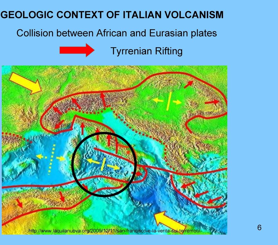
6 GEOLOGIC CONTEXT OF ITALIAN VOLCANISM Collision between African and Eurasian plates Tyrrenian Rifting 6
7 VOLCANIC AREAS IN ITALY 7

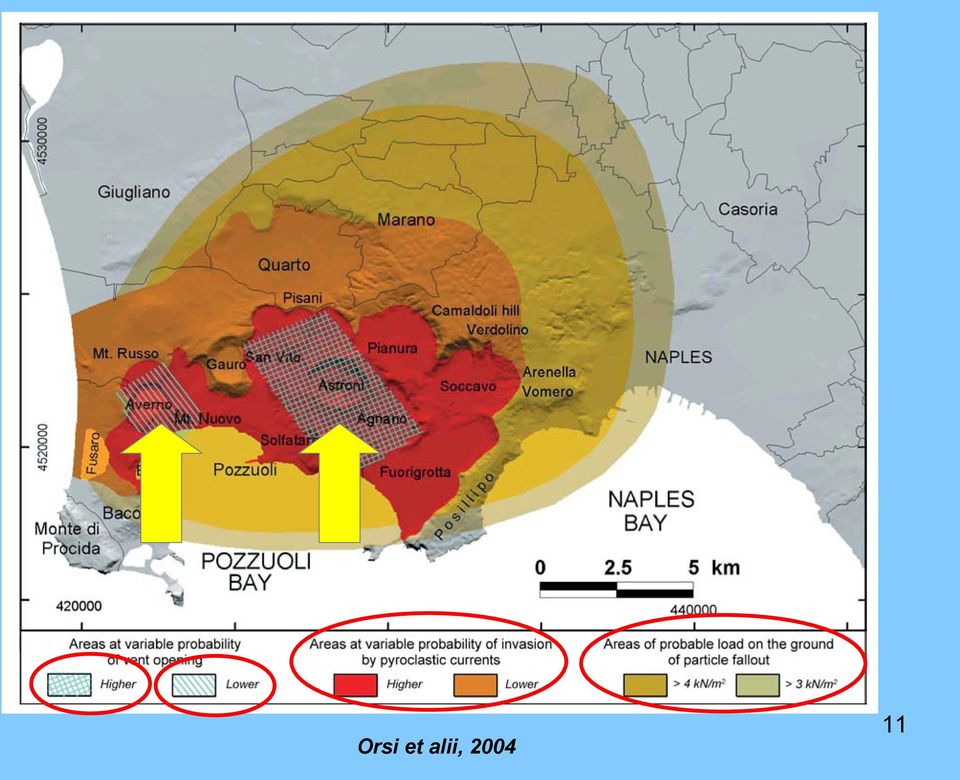
8 Neapolitan Area: Phlegrean Fields (an unrest caldera) Geological and structural sketch map of Southern Campanian Plain (Orsi et alii, 2004) Geological cross section through the Campi Flegrei caldera (Orsi et alii, 2004) - caldera (12x15 kms) - active since 60,000 years - last eruption: 1538 a.c. Mt. Nuovo (130 m a.s.l.) Mt. Nuovo, Pozzuoli 8
 Mt. Nuovo, Pozzuoli 8 http://www.ulixes.")
9 Solfatara (Pozzuoli, Naples) The "Serapium" or Macellum of Pozzuoli demonstrates the effects of bradyseism. 9

10 1.5 million people live within the caldera 350,000 people live in its active portion NEXT ERUPTION?! When? Where? How? 10

11 Orsi et alii,
12 The southeastern, instable slope of the Camaldoli hill (northern Phlegrean Fields caldera wall) - Orsi et alii (2003) The instable slope of Solfatara 12 Photo by Corrado Cencetti

13 Abandoned tuff quarry Posillipo, Napoli Active tuff quarry 13

14 Camaldoli Hill, Phlegrean Fields 14

15 Camaldoli Hill, Phlegrean Fields 15

16 Neapolitan Area: Vesuvius

17 /12/02/news-pompei-crolla/ ei.htm The city of Pompei, destroyed in 79 A.C. by the eruption of Vesuvius 17

18 18

19 Main eruptions of Vesuvius during the last 20,000 years (OsVe IDIS, 1995) maggio4c.htm 1944 eruption RED = plinian eruptions GREY-GREEN = subplinian eruptions ile:vista_vesuvio_napoli.jp g 1631 eruption GREY = strombolian eruptions WHITE = uncertain attribution diso.com/it/escursioni_guid ate.php Pompei eruption (79 a.c.) 19

20 a-24-agosto-anniversario-eruzione-del-vesuvio-del-79-dc-il-video-delleruzione-del-marzo-1944-ripreso-in-diretta/ Simplified sketch of the structure of Somma-Vesuvius (Di Vito et alii, 2011) The last eruption of Vesuvius, occurred in %20Escursioni/041_Vesuvio_Cratere_26mar06.htm Fumaroles within the main crater of Vesuvius 20
 http://teatriemusei.ovest.com/fr/cratere-du-vesuve-denaples.")
21 What can we expect by Vesuvius? Icelandic eruption Hawaian eruption Vulcanian eruption Strombolian eruption Plinian eruption Pelean eruption 21
22 4D simulations of explosive eruptions in Vesuvius (Neri et alii, 2007) The sequence shows the evolution of the distribution of temperature of pyroclastic flow (the two isosurfaces orange and pink indicates respectively 350 C and 100 C) at 300, 500, and 750 seconds from the beginning of the collapse of eruptive column. 22
23 P = relative probability of invasion by lava flows in case of eruption 0.15<p 0.10<p< <p<0.10 0<p<0.05 Probable opening of vents Areas with different probabilities to be buried by flows of lava and vents, in case of resumption of effusive activity of Vesuvius (Scandone & Cortini, 1982, modified) 23
24 Areas exposed to lahars and mud-flows in the northern slope of Vesuvius. The numbers from 1 to 4 show the areas probably affected by these phenomena in ascending order. In 24 the area 5 (grey) lahars can accumulate (Scandone & Cortini, 1982)
25 Aeolian Archipelago: Isle of Stromboli
26 / Eruptive activity in Stromboli 26
27 The Sciara del Fuoco, Stromboli The eruption of April 5, 2003 and its effects 27
28 Stromboli Ginostra 1/01/lipari-ginostra-arriva-il-sesto.html 28
29 hoto03-it.html Stromboli: flows of lava in the Sciara del Fuoco 29
30 Anomalous wave s Anomalous wave s volcano/beso/bes02c-it.html
31 The tsunami in the Isle of Stromboli (December 30, 2002) in_italia Punta Lena (Isle of Stromboli) damaged after the tsunami occurred in December 30, tsunami_2002.htm 31
32 Stromboli: the explosion of July 5,
33 Mt. Etna (Sicily) - Altitude: 3350 m a.s.l. - Area: 1250 km2 - Diameter: 35 kms - Age of the main structure: about 100,000 years 33
34 Structure of a strato-volcano 34
35 /TrekkingEtnaNord.htm Main craters in the top of Mt. Etna Minor craters on the flanks of volcano Bove Valley 35
36 36
37 by Tibaldi & Groppelli,
38 The eruption of Etna in July, 2011 The deviation of the lava flow during the eruption of 2002, close to Zafferana Etnea (Catania) 38
39 galstep=1&id=
40 Emission of ashes during the eruption of Etna made us blacks! 40
41 na millions_of_sheep_and_cattle_in_peril_over_volcani c_ash_.aspx The airport of Catania Fontanarossa (Sicily) covered by volcanic ash during the eruption of Etna of July
42 MEASURES FOR MITIGATION OF THE VOLCANIC AND VOLCANO-RELATED HAZARDS AND RISKS IN ITALY Vulnerability Exposure to phenomenon Type of hazard RISK Volcanic risk: the only possibility to reduce it is the not exposure... 42
43 Vesuvius plain
44 Province Region Municipality 44
45 o-idrogeologico-calabria-chiesto-stato-emergenza 45
46 mergenza.wp 46 e.php/?page_id=4144
47 47


48 National Service for Civil Defense Prefecture National Council of Research VOLCANIC EMERGENCY PLAN National Institute of Geophysics and Volcanology Universities National Council of Geologists 48
49 Vesuvius and Phlegrean Fields 600,000! ussione.aspx?idd= &p=37 Emergency plan of Vesuvian area 49
50 Geophysical monitoring network of Vesuvio (Orsi et alii, 2012) Vesuvian Observatory 50
51 Alert levels for Vesuvius activity n/view_pde.wp;jsessionid=9d BC206C6859D2994E3? contentid=pde
 340,000 Orsi")

52 Emergency plan and alert levels for Phlegrean Fields area (limits of Red Zone) 340,000 Orsi et alii (2003) rotezione-civile-arriva-una-leggead-hoc/ 52
53 Stromboli Sections of Catania and Palermo (Sicily) Vesuvian Observatory University of Florence 53
54 Seismic stations in the Isle of Stromboli New videocamera infrastructure with double solar panels Visible light camera installed at 400 m elevation Thermal camera installed on Pizzo Sopra la Fossa with wide-angle 54 optics and 90 horizontal aperture
55 Ground-based SAR radar interferometer installed at Stromboli for monitoring deformations of main crater an slope of Sciara del Fuoco (SdF, in the plot) by Casagli et alii (2009) Characteristics: distance = 650 m spatial resolution = 1.0 m x ca. 1.5 m accuracy = < 0,5 mm 55
56 56


57 One of the borehole strainmeter (dilatometer) installed in Stromboli. Although the dilatometer records only volumetric strain, its has the advantage of recording data at seismic frequencies
58 The C.O.A. (Centro Operativo Avanzato = Advanced Operative Centre) in the Isle of Stromboli Casagli et alii,
59 Mt. Etna
60 Previsional map of areas potentiallly affected by fall-out of volcanic ashes in case of explosive activity of Etna 60
61 Thanks for your attention 61
62 References - Casagli N., Catani F., Del Ventisette C., Guerri L., Antonello G., Fortuny-Guasch J., Tarchi D. & Leva D. (2009) - Monitoring deformations of the Stromboli volcano through ground-based radar interferometry. - Di Vito M.A., Piochi M., Mormone A. & Tramelli A. (2011) Somma Vesuvius: the Volcano and the Observatory - Field trip guidebook. REAKT - Istituto Nazionale di Geofisica e Vulcanologia, Sezione Osservatorio Vesuviano (Naples, September 22th, 2011). - Neri A., Esposti Ongaro T., Menconi G., De Michieli Vitturi M., Cavazzoni C., Erbacci G. & Baxter P.J. (2007) - 4D simulation of esplosive eruption dynamics at Vesuvius. Geophysical Research Letters, 34, DOI: /2006GL Orsi G., Cuna L., De Astis G., de Vita S., Di Vito M.A., Isaia R., Nave R., Pappalardo L., Piochi M., Postiglione C., Sansivero F. (2012) I Vulcani Napoletani: Pericolosità e Rischio. INGV - Osservatorio Vesuviano, 45 pp Orsi G., de Vita S., Di Vito M.A., Isaia R., Nave R. & Heiken G. (2003) Facing volcanic and related hazards in the Neapolitan area. In: Heiken G., Fakundiny R. & Sutter J. (Eds.) Earth Science in the City: A Reader, American Geophysical Union. - Orsi G., Di Vito M.A. & Isaia R. (2004) - Volcanic hazard assessment at the restless Campi Flegrei caldera. Bull. Volcanol., 66, DOI /s Osservatorio Vesuviano & Fondazione IDIS (1995) - Il rischio vulcanico. Il Vesuvio. Napoli, CUEN. - Scandone R. & Cortini M. (1982) Il Vesuvio: un vulcano ad alto rischio Le Scienze, 163, Tibaldi A. & Groppelli G. (2002) - Volcano-tectonic activity along structures of the unstable NE flank of Mt. Etna (Italy) and their possible origin. J. Volcanol. Geotherm. Res., 115,
2053-24. Advanced Workshop on Evaluating, Monitoring and Communicating Volcanic and Seismic Hazards in East Africa.
 2053-24 Advanced Workshop on Evaluating, Monitoring and Communicating Volcanic and Seismic Hazards in East Africa 17-28 August 2009 Emergency management in volcanic crisis: Italian cases Vittorio Bosi
Possible consequences of a volcanic crisis in southern Italy
 Possible consequences of a volcanic crisis in southern Italy Carolina Garcia PhD Student Università di Milano Bicocca Content Volcanic Products Italian Volcanoes Principal Active Italian Volcanoes Campi
The emergency planning for volcanic risk at Vesuvius and Campi Flegrei
 Roma, 9th October 2014 The emergency planning for volcanic risk at Vesuvius and Campi Flegrei Fabrizio Curcio The risks www.protezionecivile.gov.it seismic hydrogeological floods volcanic forest fire industrial
Integration between spaceand ground-based data sets: application on ground deformations measurements
 Integration between spaceand ground-based data sets: application on ground deformations measurements Giuseppe Puglisi Istituto Nazionale di Geofisica e Vulcanologia Sezione di Catania Osservatorio Etneo
CATACLYSMIC ERUPTIONS
 CATACLYSMIC ERUPTIONS The really big ones! This figure compares the size of some recent, well-known eruptions. Note how small the eruptions of Mount St. Helens and even Vesuvius are compared to Katmai,
SAR INTERFEROMETRY MONITORING OF LANDSLIDES ON THE STROMBOLI VOLCANO
 SAR INTERFEROMETRY MONITORING OF LANDSLIDES ON THE STROMBOLI VOLCANO Antonello G. (1), Casagli N. (2), Farina P. (2), Guerri L. (2), Leva D. (3), Nico G. (3), Tarchi D. (1) (1) European Commission, Joint
Field Trip Guide Book - B28
 32 nd INTERNATIONAL GEOLOGICAL CONGRESS Field Trip Guide Book - B28 THE NEAPOLITAN ACTIVE VOLCANOES (VESUVIO, CAMPI FLEGREI, ISCHIA): SCIENCE AND IMPACT ON HUMAN LIFE Leader: G. Orsi Associate Leaders:
Publications in journals
 Publications in journals Capuano, P., Russo, G., and Scarpa, R., 2013, P-wave velocity and density structure beneath Mt. Vesuvius: a magma body in the upper edifice?: Ann. Geophys., 56, 1-13, doi: 10.4401/ag-6443
CURRICULUM VITAE. Edoardo Del Pezzo January 18, 2012. Born in Naples, Italy, on march 16,1951. Nationality: Italian
 CURRICULUM VITAE Edoardo Del Pezzo January 18, 2012 1 Life. Born in Naples, Italy, on march 16,1951. Nationality: Italian Army service from August 1974 to September 1975. 2 Education. Undergraduate level
Volcanic Deposits, Landscape and Geoarchaeology of Santorini, Greece 2015 Liverpool Geological Society
 Volcanic Deposits, Landscape and Geoarchaeology of Santorini, Greece 2015 Liverpool Geological Society General Information: Dates: Monday 15 th June to Saturday 20 th June 2015 Flights: from Manchester
INSURANCE RISKS FROM VOLCANIC ERUPTIONS IN EUROPE
 INSURANCE RISKS FROM VOLCANIC ERUPTIONS IN EUROPE Professor Robin Spence & Dr Rashmin Gunesekara Willis Research Network 51 Lime Street London EC3M 7DQ +44 (0) 20 3124 7482 and Professor Giulio Zuccaro
Project V3 Lava PROJECT V3 LAVA
 Project V3 Lava PROJECT V3 LAVA 177 178 Project V3 Lava Coordinators: Project V3 - LAVA Realization of the lava flow hazard map at Mount Etna and set up of a method for its dynamic update Ciro Del Negro,
Geological hazards and monitoring activities at the Azores archipelago
 Geological hazards and monitoring activities at the Azores archipelago Teresa Ferreira (1,2), João Gaspar (1,2), Gabriela Queiroz (1,2) (1) CVARG (Centre for Volcanology and Geological Risks Assessment)
INGV-DPC Projects 2007 2009 VOLCANOLOGY
 INGV-DPC Projects 2007 2009 VOLCANOLOGY INGV DPC Projects 2007 2009 Volcanology Cover pictures: top: Etna, 2001 eruption. Ash plume and fallout seen from the Nicolosi Rifugio Sapienza road. Photo by P.
Monitoring radon emission anomalies at Stromboli Island as a tracer of eruptive events and near field earthquakes
 EPJ Web of Conferences 24, 05002 (2012) DOI: 10.1051/ epjconf/ 20122405002 C Owned by the authors, published by EDP Sciences - SIF, 2012 Monitoring radon emission anomalies at Stromboli Island as a tracer
Chronology of the 2007 eruption of Stromboli and the activity of the Scientific Synthesis Group
 ÔØ Å ÒÙ Ö ÔØ Chronology of the 2007 eruption of Stromboli and the activity of the Scientific Synthesis Group Franco Barberi, Lucia Civetta, Mauro Rosi, Roberto Scandone PII: S0377-0273(08)00538-6 DOI:
Volcanic Hazards & Prediction of Volcanic Eruptions
 Page 1 of 11 EENS 3050 Tulane University Natural Disasters Prof. Stephen A. Nelson Volcanic Hazards & Prediction of Volcanic Eruptions This page last updated on 03-Jul-2012 Volcanic Hazards This lecture
The dynamics of magma chamber refilling at
 Vertical deformation Seismogram Gravity change The dynamics of magma chamber refilling at the Campi Flegrei caldera A. Longo 1, C. Montagna 1, M. Vassalli 2, P. Papale 1, D. Giudice 1, G. Saccorotti 1
Contributors to report
 1. The Global Volcano Model (GVM; http://globalvolcanomodel.org/) was launched in 2011 and has grown to include 31 partner institutes collaborating from across the globe representing scientists from disciplines
RESEARCH ARTICLE. Anthony Finizola Francesco Sortino Jean-François LØnat Maurice Aubert Maurizio Ripepe Mariano Valenza
 Bull Volcanol (2003) 65:486 504 DOI 10.1007/s00445-003-0276-z RESEARCH ARTICLE Anthony Finizola Francesco Sortino Jean-François LØnat Maurice Aubert Maurizio Ripepe Mariano Valenza The summit hydrothermal
A disaster occurs at the point of contact between social activities and a natural phenomenon of unusual scale.
 Hazard Mapping and Vulnerability Assessment Mr. Toshiaki Udono Senior Project Manager, Kansai Division, PASCO Corporation, Japan Mr. Awadh Kishor Sah Project Manager, Project Implementation Department,
A remote sensing instrument collects information about an object or phenomenon within the
 Satellite Remote Sensing GE 4150- Natural Hazards Some slides taken from Ann Maclean: Introduction to Digital Image Processing Remote Sensing the art, science, and technology of obtaining reliable information
How can we defend ourselves from the hazard of Nature in the modern society?
 How can we defend ourselves from the hazard of Nature in the modern society?, University of Bologna President of the EGU Division of Natural Hazards Email: stefano.tinti@unibo.it nh@egu.eu GIFT 2013 Natural
Consequences of Liquid Tank Explosions Caused by Lava Flow
 A publication of CHEMICAL ENGINEERING TRANSACTIONS VOL. 43, 2015 Chief Editors: Sauro Pierucci, Jiří J. Klemeš Copyright 2015, AIDIC Servizi S.r.l., ISBN 978-88-95608-34-1; ISSN 2283-9216 The Italian Association
THE AEOLIAN ISLANDS John Parkins
 THE AEOLIAN ISLANDS John Parkins The Aeolian Islands are a volcanic group off the northeast coast of Sicily, the nearest being visible from the mainland. The name is sometimes modernised to Eolian. They
Modeling Volcanic Eruptions
 Modeling Volcanic Eruptions New Mexico Adventures in Supercomputing Challenge Final Report April 6, 2005 Team 052 Rio Rancho Mid-High School Team Members John Bell Nick Vigil Teacher Sponsor Debra Loftin
A trip in Campania Region through the hellenic tradition of. Four Elements. Naples, where AIR, FIRE, EARTH and WATER coexist harmonically
 A trip in Campania Region through the hellenic tradition of Four Elements Naples, where AIR, FIRE, EARTH and WATER coexist harmonically FIRE fire to destroy, fire to enchant POMPEII The Unesco World Heritage
ERMES. Monitoring of radon in geogas at the Gran Sasso National Laboratory
 ERMES. Monitoring of radon in geogas at the Gran Sasso National Laboratory G. De Luca a and W. Plastino b a Istituto Nazionale di Geofisica e Vulcanologia (INGV) Centro Nazionale Terremoti (CNT), Via di
EFG Summer Council Meeting May 31 - June 1, 2014
 Workshop Geologists of Europe in the 3 rd millennium May 29-30, 2014 EFG Summer Council Meeting May 31 - June 1, 2014 Palermo (Italy) A N N O U N C E M E N T 1 The Consiglio Nazionale dei Geologi - Italian
REDUCTION OF THE ECONOMIC-FINANCIAL EXPOSURE OF THE STATE AND PROTECTION OF HUMAN LIVES
 REDUCTION OF THE ECONOMIC-FINANCIAL EXPOSURE OF THE STATE AND PROTECTION OF HUMAN LIVES Models for the prevention and mitigation of damages to people and properties through an insurance coverage PRESENTATION
PROJECT TITLE. ACTIVITY REPORT 2nd YEAR
 PROJECT TITLE CHEMICAL AND ISOTOPIC CHARACTERISTICS OF GASES AND GROUNDWATERS AT VESUVIO, CAMPI FLEGREI, ISCHIA AND VULCANO: EVALUATION OF THE VOLCANIC RISK Scientific Coordinator Name-Position: Stanzione
Which Way are We Going? Online Mapping Tools to Help People Visualize Plate Motions with GPS Data. Shelley Olds, UNAVCO
 Which Way are We Going? Online Mapping Tools to Help People Visualize Plate Motions with GPS Data Shelley Olds, UNAVCO Tools to help people visualize science concepts Temporal & Spatial scales can be difficult
FIRST GRADE VOLCANOES 1 WEEK LESSON PLANS AND ACTIVITIES
 FIRST GRADE VOLCANOES 1 WEEK LESSON PLANS AND ACTIVITIES PLATE TECTONIC CYCLE OVERVIEW OF FIRST GRADE VOLCANOES WEEK 1. PRE: Learning the shapes of volcanoes. LAB: Experimenting with "lava." POST: Comparing
Mapping and Characterising Volcanic Risk
 Mapping and Characterising Volcanic Risk Stephen Sparks 1, Willy Aspinall 1, Mel Auker 1, Sian Crosweller 1, Thea Hincks 1, Sue Mahony 1, Farrokh Nadim 2, Jenny Pooley 1 and Egil Syre 2 1. Department of
MODELLING VOLCANIC RISK
 MODELLING VOLCANIC RISK Susanna Jenkins Cabot Institute, University of Bristol Susanna.Jenkins@Bristol.ac.uk Damage to the village of Balerante, 5km from Merapi volcano during the October-November 2010
P1.2 NUMERICAL SIMULATION OF LONG DISTANCE TRANSPORTATION OF VOLCANO ASH FROM PINATUBO
 P1.2 NUMERICAL SIMULATION OF LONG DISTANCE TRANSPORTATION OF VOLCANO ASH FROM PINATUBO Tan Jiqing Xu Juan (Institution of Meteorological Information and Prediction of Disaster Events, Zhejiang University,
ERS-ENVISAT ENVISAT deformation time-series analysis: a unique opportunity to investigate long term surface deformation of large areas
 ERS-ENVISAT ENVISAT deformation time-series analysis: a unique opportunity to investigate long term surface deformation of large areas R. Lanari 1, P. Berardino 1, M. Bonano 1,2, F. Casu 1, A. Manconi
GCSE GEOGARPHY OCR B REVISION GUIDE Natural Hazards
 GCSE GEOGARPHY OCR B REVISION GUIDE Natural Hazards Tectonic Hazards A natural hazard is an extreme natural event or process that causes loss of life and/or extreme damage to property and creates severe
HIGH RESOLUTION MONITORING OF CAMPI FLEGREI (NAPLES, ITALY) BY EXPLOITING TERRASAR-X DATA: AN APPLICATION TO SOLFATARA CRATER
 BY EXPLOITING TERRASAR-X DATA: AN APPLICATION TO SOLFATARA CRATER") HIGH RESOLUTION MONITORING OF CAMPI FLEGREI (NAPLES, ITALY) BY EXPLOITING TERRASAR-X DATA: AN APPLICATION TO SOLFATARA CRATER Christian Minet (1), Kanika Goel (1), Ida Aquino (2), Rosario Avino (2), Giovanna
HIGH RESOLUTION MONITORING OF CAMPI FLEGREI (NAPLES, ITALY) BY EXPLOITING TERRASAR-X DATA: AN APPLICATION TO SOLFATARA CRATER Christian Minet (1), Kanika Goel (1), Ida Aquino (2), Rosario Avino (2), Giovanna
PI: Riccardo Lanari (IREA CNR) email:lanari.r@irea.cnr.it
 email:lanari.r@irea.cnr.it") On the exploitation and validation of COSMO-SkyMed interferometric SAR data for digital terrain modelling and surface deformation analysis in extensive urban areas (ID: 1441) Project partners: Istituto
On the exploitation and validation of COSMO-SkyMed interferometric SAR data for digital terrain modelling and surface deformation analysis in extensive urban areas (ID: 1441) Project partners: Istituto
 Multidisciplinary volcano monitoring programs and their use in risk assessment J. Neuberg School of Earth & Environment - Institute of Geophysics & Tectonics -The University of Leeds - Leeds LS2 9JT -
Regents Questions: Plate Tectonics
 Earth Science Regents Questions: Plate Tectonics Name: Date: Period: August 2013 Due Date: 17 Compared to the oceanic crust, the continental crust is (1) less dense and more basaltic (3) more dense and
Geol 101: Physical Geology PAST EXAM QUESTIONS LECTURE 4: PLATE TECTONICS II
 Geol 101: Physical Geology PAST EXAM QUESTIONS LECTURE 4: PLATE TECTONICS II 4. Which of the following statements about paleomagnetism at spreading ridges is FALSE? A. there is a clear pattern of paleomagnetic
M ODELLO PER IL CURRICULUM VITAE
 M ODELLO PER IL CURRICULUM VITAE INFORMAZIONI PERSONALI Nome CHIODINI GIOVANNI Data di nascita 30, GENNAIO, 1956 Qualifica Dirigente di ricerca Amministrazione INGV, sezione di Napoli, Osservatorio Vesuviano
Chincha and Cañete, Peru, Based
 Reconstruction of Ica, Pisco, Chincha and Cañete, Peru, Based on Updated Hazard Maps Julio Kuroiwa Professor emeritus National University of Engineering and UNDP Reconstruction Program/Sustainable Cities.
HAZARD MAPPING, RISK ASSESSMENT, AND INSURANCE COVERAGE OF NATURAL CATASTROPHE RISK
 SESSION III HAZARD MAPPING, RISK ASSESSMENT, AND INSURANCE COVERAGE OF NATURAL CATASTROPHE RISK Mr. Sumarjono Insurance Bureau of The Ministry of Finance of the Republic of Indonesia Geological Position
THE NATIONAL ASSOCIATION OF ITALIAN MOUNTAIN GUIDES THE REGIONAL ASSOCIATION OF SICILIAN MOUNTAIN AND VOLCANOLOGICAL GUIDES ORGANIZE
 THE NATIONAL ASSOCIATION OF ITALIAN MOUNTAIN GUIDES THE REGIONAL ASSOCIATION OF SICILIAN MOUNTAIN AND VOLCANOLOGICAL GUIDES ORGANIZE IFMGA GENERAL ASSEMBLY TECHNICAL COMMITTEE BOARD 1-5 MAY 2016 MOUNT
Some Processes that Change the Earth s Surface
 PART ONE Some Processes that Change the Earth s Surface Science standards To prepare students to understand the Essential Academic Learning Requirements (EALRs) introduced at middle school, this series
FROM DRAWING ANTICLINE AXES TO 3D MODELLING OF SEISMOGENIC SOURCES: EVOLUTION OF SEISMOTECTONIC MAPPING IN THE PO PLAIN
 FROM DRAWING ANTICLINE AXES TO 3D MODELLING OF SEISMOGENIC SOURCES: EVOLUTION OF SEISMOTECTONIC MAPPING IN THE PO PLAIN Burrato P.*, Maesano F. E. *, D Ambrogi C.**, Toscani G., Valensise G.* (*) INGV,
People/environment relationships from the Mesolithic to the Middle Ages: recent geo-archaeological findings in Southern Italy.
 The Dipartimento di Scienze della Terra of the University Federico II, Naples is pleased to announce the International Congress People/environment relationships from the Mesolithic to the Middle Ages:
Glacier-clad volcanoes
 Glaciers in an Environmental Context Natural hazards in glacierized regions: Glacier-clad volcanoes Contribution by Demian Schneider Eyjafjallajökull, Iceland, April 2010 Overview 1. Distribution of
MAJOR LANDFORMS IN VOLCANIC REGIONS
 MAJOR LANDFORMS IN VOLCANIC REGIONS Volcanism is not randomly distributed over the world. It is concentrated near plate boundaries where plate subduction or seafloor spreading takes place. Other occurrences
Volcanoes. Talking About Disaster: Guide for Standard Messages. Volcanoes-1. March 2007
 Volcanoes Learn about your community s risk from hazards created by volcanic eruptions. While you may be located far from a volcano, the ash from an explosive eruption could affect your area. Contact your
Chapter 5: Magma And Volcanoes
 Chapter 5: Magma And Volcanoes Introduction: Earth s Internal Thermal Engine Magma is molten rock beneath Earth s surface. Because liquid magma is less dense than surrounding solid rock, and obviously
CO 2 storage science development and application in Italy
 CO 2 storage science development and application in Italy Salvatore Lombardi Carbon Sequestration Leadership Forum, 16-19 April 2013 Rome, Italy Objectives Site selection and characterization Acquisition
CAPRA Software Gabriel Bernal ITEC SAS - ERN-AL Consortium
 CAPRA Software Gabriel Bernal ITEC SAS - ERN-AL Consortium ERN CAPRA software CAPRA platform Data management FileCAT Hazard module Exposure module Vulnerability module Risk module CRISIS 2007 ERN-NH rainfall
DISTRIBUTION OF ACTIVE VOLCANOES
 DISTRIBUTION OF ACTIVE VOLCANOES The earth is a dynamic planet. Its rigid outer surface layer is broken into several tectonic plates which are in constant motion relative to one another. As demonstrated
Somma Vesuvius: the Volcano and the Observatory
 Somma Vesuvius: the Volcano and the Observatory Field trip guidebook REAKT Mauro Antonio Di Vito, Monica Piochi, Angela Mormone, Anna Tramelli Istituto Nazionale di Geofisica e Vulcanologia, sezione Osservatorio
via C. Baruzzi 10, 40138, Bologna, Italy Telephone(s) +39 0514151457 Mobile: +39 3478729410
 +39 0514151457 Mobile: +39 3478729410") Personal information Surname(s) / First name(s) Address(es) via C. Baruzzi 10, 40138, Bologna, Italy Telephone(s) +39 0514151457 Mobile: +39 3478729410 Email(s) Nationality(-ies) jacopo.selva@bo.ingv.it
Personal information Surname(s) / First name(s) Address(es) via C. Baruzzi 10, 40138, Bologna, Italy Telephone(s) +39 0514151457 Mobile: +39 3478729410 Email(s) Nationality(-ies) jacopo.selva@bo.ingv.it
 1 2 A very short description of the functional center network: regarding the Hydraulic and Hydrogeological risk, the national alert system is ensured by the National Civil Protection Department (DPCN),
Geohazards: Minimizing Risk, Maximizing Awareness The Role of the Insurance Industry
 Geohazards: Minimizing Risk, Maximizing Awareness The Role of the Insurance Industry Prof. Dr. Peter Hoeppe Head of Geo Risks Research Munich Re International Year of Planet Earth, Paris, 13 February 2008
Overlapping rifts in southern Iceland QUEST field trips: 15 and 17 July 2011 Freysteinn Sigmundsson (fs@hi.is)
") Overlapping rifts in southern Iceland QUEST field trips: 15 and 17 July 2011 Freysteinn Sigmundsson (fs@hi.is) The geological map of Iceland gives an excellent overview. The plate boundary is broken up
Overlapping rifts in southern Iceland QUEST field trips: 15 and 17 July 2011 Freysteinn Sigmundsson (fs@hi.is) The geological map of Iceland gives an excellent overview. The plate boundary is broken up
Introduction dangerous neighbors: volcanoes near cities
 Introduction dangerous neighbors: volcanoes near cities crisis in the congo It was a total disaster: tens of millions of yards of lava flowed down the volcano s lower slopes and into the city of Goma in
How To Explore A Hot Spring
 Exploration Techniques The Geothermal Institute University of Auckland Bridget Lynne Santiago de Chile, 26-29 May 2014 Exploration Techniques Bridget Y. Lynne New techniques in geothermal exploration NZ
The seismic activity in the area of Greece between 1966 and 1969
 The seismic activity in the area of Greece between 1966 and 1969 P. A. GIANNAKOPOULOS * Received on March 28'", 1972 SUMMARY. The earthquake activity in the area of Greece for the years 1966, 1967, 1968
When Things Go Wrong
 When Things Go Wrong When Things Go Wrong Our planet has many wondrous things. We plant a tiny sapling and it becomes a mighty tree. Water runs in rivers. Rainbows appear in the sky. But it is not always
Between June and November, 1989, I had an opportunity to work at Nagasaki
 MOUNT UNZEN: AN ACTIVE VOLCANO OF SOUTHWESTERN JAPAN WHICH WAS VISITED BY GURUDEV RABINDRA NATH TAGORE IN MAY 1924 Arun Kumar Mount Unzen (32.75degrees N, 130.30 degrees E) is an active group of stratovolcanoes
Research Networking Programme Measuring and Modelling of Volcano Eruption Dynamic (MeMoVolc)
") Research Networking Programme Measuring and Modelling of Volcano Eruption Dynamic (MeMoVolc) Standing Committee for Life, Earth and Environmental Sciences (LESC) Europe is host to about 50 historically
Research Networking Programme Measuring and Modelling of Volcano Eruption Dynamic (MeMoVolc) Standing Committee for Life, Earth and Environmental Sciences (LESC) Europe is host to about 50 historically
Report. Networking of school seismology groups across Europe evaluation report
 Network of European Research Infrastructures for Earthquake Risk Assessment and Mitigation Report Networking of school seismology groups across Europe evaluation report Activity: Networking School Seismology
Stratovolcano growth by co eruptive intrusion: The 2008 eruption of Tungurahua Ecuador
 GEOPHYSICAL RESEARCH LETTERS, VOL. 37,, doi:10.1029/2010gl044942, 2010 Stratovolcano growth by co eruptive intrusion: The 2008 eruption of Tungurahua Ecuador J. Biggs, 1,2,3 P. Mothes, 4 M. Ruiz, 4 F.
DOE s EGS Program Review
 DOE s EGS Program Review EGS Database Development Susan Petty Black Mountain Technology Ph: 206-217-5960 Fax: 206-285-0425 spetty@blackmountaintechnology.com Project Objective Original objective: Develop
Analysis and Classification of Volcanic Eruptions
 Analysis and Classification of Volcanic Eruptions Prof. S. C. Wirasinghe, PEng (APEGA) Ms. H. Jithamala Caldera I 3 R 2 May 2014 Purdue University Department of Civil Engineering, Schulich School of Engineering
Abnormal Leader Processes in a Classically-Triggered Negative Discharge Observed with a Broadband VHF Interferometer and a Camera in 3D
 Abnormal Leader Processes in a Classically-Triggered Negative Discharge Observed with a Broadband VHF Interferometer and a Camera in 3D Mingli Chen 1,*, Yanchi Shen 1, Wansheng Dong 2 1. The Hong Kong
Unit 6 Earthquakes and Volcanoes
 Unit 6 Earthquakes and Volcanoes Earthquakes and Volcanoes: Essential Questions What evidence can students observe that the Earth is changing? How do scientists know what s inside the Earth? What processes
Hakim Saibi 1, Jun Nishijima 2, Sachio Ehara 2, Yasuhiro Fujimitsu 2 and Koichiro Fukuoka 2
 PROCEEDINGS, Thirtieth Workshop on Geothermal Reservoir Engineering Stanford University, Stanford, California, January 31-February 2, 2 SGP-TR-176 DETERMINATION OF SHALLOW GROUNDWATER LEVEL CHANGE USING
Tsunami generation in Stromboli island and impact on the south-east Tyrrhenian coasts
 Tsunami generation in Stromboli island and impact on the south-east Tyrrhenian coasts S. Tinti, G. Pagnoni, F. Zaniboni, E. Bortolucci To cite this version: S. Tinti, G. Pagnoni, F. Zaniboni, E. Bortolucci.
Application of TanDEM-X interferometry in volcano monitoring using Merapi, Indonesia and Volcán de Colima, Mexico as test sites
 , Malte Westerhaus, Bernhard Heck Application of TanDEM-X interferometry in volcano monitoring using Merapi, Indonesia and Volcán de Colima, Mexico as test sites, Department of Civil Engineering, Geo and
THE SUBMARINE PORTIONS OF ITALIAN VOLCANOES: THEIR SURVEY AND ASSESSMENT OF THE POTENTIAL VOLCANIC HAZARDS. ACTIVITY REPORT 2nd YEAR
 THE SUBMARINE PORTIONS OF ITALIAN VOLCANOES: THEIR SURVEY AND ASSESSMENT OF THE POTENTIAL VOLCANIC HAZARDS Scientific Co-ordinator Francesco Latino Chiocci Professor Dipartimento Scienze della Terra, Università
Understanding Disaster Risk on Volcanic Islands: a Research Agenda
 Understanding Disaster Risk on Volcanic Islands: a Research Agenda C. J. Lowe 1, 2, M. Haklay 3, P. Longley 1, W. J. McGuire 2 1 Deparment of Geography, 2 Benfield UCL Hazard Research Centre, 3 Department
NATURAL AND HUMAN INDUCED HAZARDS Vol. I - Environmental Impacts of Volcanic Eruptions - V.Yu. Kirianov ENVIRONMENTAL IMPACTS OF VOLCANIC ERUPTIONS
 ENVIRONMENTAL IMPACTS OF VOLCANIC ERUPTIONS V.Yu. Kirianov Institute of Volcanic Geology and Geochemistry RAS, Petropavlovsk-Kamchatsky, Russia Keywords: volcanic eruptions, climate, glaciation, volcanic
Direttore. Enzo Boschi. Comitato di Redazione. Cesidio Bianchi Tecnologia Geofisica. Rodolfo Console Sismologia
 COPERTINA Direttore Enzo Boschi Comitato di Redazione Cesidio Bianchi Tecnologia Geofisica Rodolfo Console Sismologia Giorgiana De Franceschi Relazioni Sole-Terra Leonardo Sagnotti Geomagnetismo Giancarlo
The 2008 eruption of the Chaitén Volcano, Chile: a preliminary report
 Andean Geology 36 (1): 125-129. January, 2009 Andean Geology formerly Revista Geológica de Chile www.scielo.cl/rgch.htm GEOLOGICAL NOTE The 2008 eruption of the Chaitén Volcano, Chile: a preliminary report
Relationship between tremor and volcanic activity during the Southeast Crater eruption on Mount Etna in early 2000
 JOURNAL OF GEOPHYSICAL RESEARCH, VOL. 108, NO. B5, 2241, doi:10.1029/2002jb001866, 2003 Relationship between tremor and volcanic activity during the Southeast Crater eruption on Mount Etna in early 2000
Viscosity experiments: physical controls and implications for volcanic hazards. Ben Edwards Dept of Geology, Dickinson College
 Viscosity experiments: physical controls and implications for volcanic hazards Student Name: Ben Edwards Dept of Geology, Dickinson College OBJECTIVES OF LAB Learn about the rheological property called
Dr. Nicolas LE CORVEC
 April 2015 Dr. Nicolas LE CORVEC USRA - Lunar and Planetary Institute 3600 Bay Area Blvd Houston, TX, 77058 Phone: (1) 281-486-2118 Fax: (1) 281-486-2126 lecorvec@lpi.usra.edu Date of Birth: 5 th January
Jun NISHIJIMA, Daisuke OKA, Satoru HIGUCHI Yasuhiro FUJIMITSU, Junichi TAKAYAMA and Naoto HIRAGA
 Proceedings World Geothermal Congress 2015 Melbourne, Australia, 19-25 April 2015 Repeat Microgravity Measurements Using Absolute and Relative Gravimeters for Geothermal Reservoir Monitoring in Ogiri Geothermal
Using Remotely Sensed Data From ASTER to Look Impact of Recent Earth Quakes in Gujarat, India.
 Using Remotely Sensed Data From ASTER to Look Impact of Recent Earth Quakes in Gujarat, India. A major earth quake occurred in Gujarat, India on January 26,2000. (Origin time 03:16 GMT, Location 23.399N
Embedding a geographic information system in a decision support system for landslide hazard monitoring
 Excerpt from: Marco Lazzari, Paolo Salvaneschi, "Embedding a Geographic Information Embedding a geographic information system in a decision support system for landslide hazard monitoring Marco Lazzari,
CURRICULUM VITAE. Marco Masetti
 CURRICULUM VITAE Marco Masetti Dipartimento di Scienze della Terra A. Desio, Via Mangiagalli 34, 20133 Milan MI (Italy) Email: marco.masetti@unimi.it, Phone: +39 0250315507 Fax: +39 0250315494 Present
L Aquila Earthquake in Italy
 L Aquila Earthquake in Italy Gian Paolo Cimellaro Assistant professor, Department of Structural and Geotechnical engineering, Politecnico di Torino April 15, 2009 Room 140 Outline geology at the site of
Geological 3D-model of the Basel region - a tool to explore geopotentials. Dr. Horst Dresmann. Prof. Peter Huggenberger. Dr.
 Geological 3D-model of the Basel region - a tool to explore geopotentials Dr. Horst Dresmann Prof. Peter Huggenberger Dr. Janis Epting GeORG technical workshop 18.11.2010, Freiburg 1/24 Where are useable
CONFIRMATION AND CALIBRATION OF COMPUTER MODELING OF TSUNAMIS PRODUCED BY AUGUSTINE VOLCANO, ALASKA
 CONFIRMATION AND CALIBRATION OF COMPUTER MODELING OF TSUNAMIS PRODUCED BY AUGUSTINE VOLCANO, ALASKA James E. Beget Geophysical Institute and Alaska Volcano Observatory University of Alaska, Fairbanks,
CHAPTER 6 THE TERRESTRIAL PLANETS
 CHAPTER 6 THE TERRESTRIAL PLANETS MULTIPLE CHOICE 1. Which of the following is NOT one of the four stages in the development of a terrestrial planet? 2. That Earth, evidence that Earth differentiated.
IAG/AIG-WG-TG Summer School 2016 on Alps vs Apennines: Tectonic Geomorphology of Mountains
 IAG/AIG-WG-TG Summer School 2016 on Alps vs Apennines: Tectonic Geomorphology of Mountains Italy: Western Alps (Peveragno, CN) Central Apennines (Assergi, AQ) July 2-9, 2016 Aim and scope The IAG-WG-TG
Chesapeake Bay Governor School for Marine and Environmental Science
 Choose the best answer and write on the answer sheet provided. 1. Which of the following is LEAST likely to be an effect of global warming? (a) Loss of fertile delta regions for agriculture (b) Change
2053-2. Advanced Workshop on Evaluating, Monitoring and Communicating Volcanic and Seismic Hazards in East Africa.
 2053-2 Advanced Workshop on Evaluating, Monitoring and Communicating Volcanic and Seismic Hazards in East Africa 17-28 August 2009 The assessment of volcanic hazards, vulnerability, risk and uncertainty
FOURTH GRADE PLATE TECTONICS 1 WEEK LESSON PLANS AND ACTIVITIES
 FOURTH GRADE PLATE TECTONICS 1 WEEK LESSON PLANS AND ACTIVITIES PLATE TECTONIC CYCLE OVERVIEW OF FOURTH GRADE VOLCANOES WEEK 1. PRE: Comparing different structures of volcanoes. LAB: Modeling three types
Structural assessment of Mount Etna volcano from Permanent Scatterers analysis
 Article Volume 12, Number 2 9 February 2011 Q02002, doi:10.1029/2010gc003213 ISSN: 1525 2027 Structural assessment of Mount Etna volcano from Permanent Scatterers analysis Alessandro Bonforte, Francesco
INTRODUCTION. This project is about volcanoes and how they form and how they function. It will also show you the different aspects of a volcano.
 BY RYAN O MAHONY INTRODUCTION This project is about volcanoes and how they form and how they function. It will also show you the different aspects of a volcano. MAP OF VOLCANOES AROUND THE WORLD DIAGRAM
PLATE TECTONICS EXERCISE (Modified from North Seattle Community College online exercise)
") PLATE TECTONICS EXERCISE (Modified from North Seattle Community College online exercise) Introduction: As discussed in our textbook, the speed at which tectonic plates move has been calculated in several
PLATE TECTONICS EXERCISE (Modified from North Seattle Community College online exercise) Introduction: As discussed in our textbook, the speed at which tectonic plates move has been calculated in several