Welcome to Middle Earth
|
|
|
- Cornelius Craig
- 7 years ago
- Views:
Transcription
1 Welcome to Middle Earth Garth Eyles Trustee of the New Zealand Poplar and Willow Research Trust

2
3

4

5
6

7

8
9 New Zealand s Erosion History Humans have increased the rate of erosion up to 16 times greater under pasture compared to native forest. From the 1500s Maori burnt vegetation creating a fern cover a thick, tangled mass of living and dead fronds providing generally good erosion protection. From the 1830s Europeans converted fern and forest to English pastures.
10 Soil fertility of hill country pastures declined until after WW11 when aerial topdressing was introduced. Catchment Boards were established from 1941 to control flooding and soil erosion. The Government required erosion control measures to allow continued stock grazing. Willow and poplar poles were the only trees that met this requirement.
11 From the 1950s poplars and willows were selected and bred for erosion control. The programme was led by Chris van Kraayenoord, culminating in the establishment of the National Plant Materials Centre. In the mid 1990s government dramatically reduced financial support for the poplar and willow breeding programmes causing the closure of the Centre. The breeding programme continued under survival mode conditions.
12 In 1976 New Zealand joined the International Poplar Commission The Poplar and Willow Trust was formed to support the development and release of new, versatile poplar and willow clones. Sufficient funding is currently available to enable a sustainable programme.
13 The Poplar and Willow Research Trust Our goal is to develop robust poplars and willows for protecting erosion prone soils, particularly on pastoral hill country slopes. The Trustees represent the interests of regional councils, and the NZ primary production sectors - pastoral, dairy and horticulture. The Trust currently employs two scientists. The Trust gains funding and sponsorship from government and the private sector.
14 Why do we need poplars and willows? This next section provides a thumb nail summary of soil erosion in New Zealand. Unlike most areas of the world we have pastured, and graze most of our hill country, irrespective of its natural stability or fertility. Erosion is a constant threat to sustainability, with landslide (slipping) and fluvial (gully) erosion the major concerns.
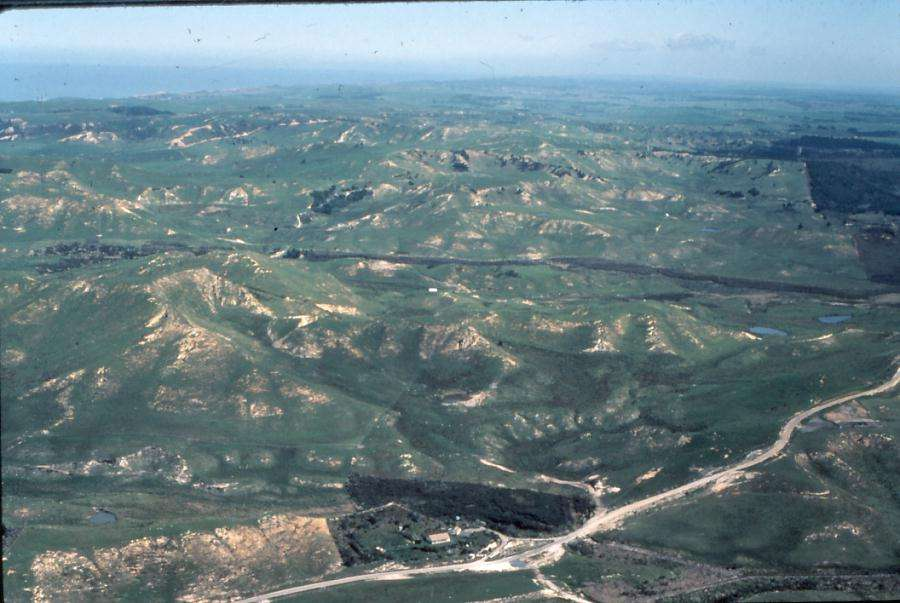
15 Region Area at risk (hectares) At-risk area being farmed Percentage of farmland that is: stable erodible Northland 874, ,100 (60%) Auckland 263, ,600 (57%) Waikato 945, ,700 (54%) Bay of Plenty 682, ,500 (22%) Gisborne 697, ,300 (71%) Hawke s Bay 967, ,900 (56%) Taranaki 341, ,000 (34%) Manawatu-Whanganui 1,299, ,700 (62%) Wellington 454, ,100 (61%) New Zealand 18,382,200 8,681,000 (47%) Erosion susceptible land in New Zealand (State of New Zealand s Environment 1997, MfE, Chapter Eight and Clough & Hicks, 1993, 4)
16
17 Source: Clough & Hicks, 1993, 6
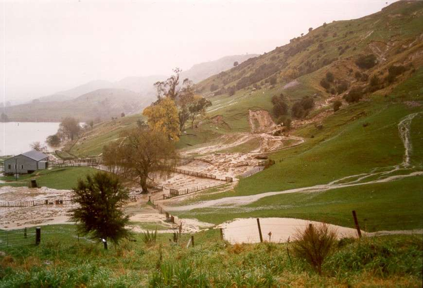
18 Sheet erosion Occurs when surface soil material is washed off. An insidious erosion form as it removes fertiliser and topsoil. Controlled by maintaining a complete surface cover. Heavy stock can shear low strength hill country soils.
19
20 Wind erosion Wind erosion can occur on any bare surface. Most fine tilths blow. Volcanic ash (tephric) soils are very susceptible. Wind erosion is controlled by shelter belts and ground cover.

21
22 Slip erosion Slips are the rapid sliding or flowing of soil and regolith, exposing a distinct slip surface. Slips occur during heavy rains when the soil gets saturated and slides/floats off downslope. Production on the slip scar never gets back to more than 80% of the uneroded surface. Slip erosion is controlled by space or close planted trees.

23 Note the sharp boundary between the soil and underlying rock, forming a slip plane.
24

25 Soil Slip on Pohangina sands in 2004
26 On individual farms up to 30% of sub catchments can be affected by one event. Severe storms generally affect about 5% of a farm.
27 Rate of pasture recovery on slips. From replicated studies in the Wairarapa and Wairoa areas.

28 Multi purpose plantings reduce the risk of slip erosion. Central Hawke s Bay.
29 Earthflow erosion Earthflow is the flow of soil and underlying regolith and parent material. It is usually characterised by the retention of a surface cover, broken by tension cracks and smaller secondary movements.

30 Deep Earthflow Erosion G O Eyles

31 Shallow earthflow on frittered mudstone

32 Shallow Earthflow Erosion stabilised by space planted poplars G Eyles

33 A partly planted hill slope susceptible to earthflow
34 Gully erosion The type of gully depends on the rock type. Gullies are very significant as they: Remove large amounts of debris into waterways and downstream deposition sites Destroy on-farm communication lines Destroy fences Are hard to repair.

35 Gully formed in uncemented ignimbrite S Stokes

36

37 The underlying rock has a ph of about 2.1 making remedial planting very difficult.

38 Gullies on mudstone are often combined with earthflow to form a complex system.

39 Photo: Gisborne District Council The debris dams are built progressively and act as a series of controlled drop structures.

40 Photo: Gisborne District Council Long term control of gully erosion relies on the root mats of willows planted in conjunction with debris dams.
41 Tunnel Gully erosion Occurs where concentrated subsurface flows are parallel to the surface, creating tunnels which collapse.

42 Tunnel Gully Erosion in clay soils G Eyles

43 Photo: Northland Regional Council

44 Photo: Northland Regional Council

45
46 Stream bank erosion Stream bank erosion is the removal of material from the bank during or following floods. Stream bank protection using willows is a major river control activity.

47 Photo: N Ngapo

48

49

50 Deposition
51 On Farm erosion control Tree planting is the main control measure used but effective planning is needed. Farm Plans are the most effective planning tool to minimise erosion while maximising production as they identify where erosion is likely to be a problem. Individual works involve the planting of poplars and willows.
52
53
54 The versatility of Poplars and Willows Poplars and willows are not widely used as a timber tree. In addition to erosion control they have many on farm uses some of which are: Shade Shelter Fodder Phyto remediation

55

56

57

58

59

60 References
Waterway Technote Planning
 Waterway Technote Planning Contents Benefits to planning your waterway management 1 Prioritising waterway management where to start? 1 What are your priorities? 1 Start with the best areas or those at
Tool 2.3.1: General information on the causes of rainfall-induced landslides
 Impacts of Climate Change on Urban Infrastructure & the Built Environment A Toolbox Tool 2.3.1: General information on the causes of rainfall-induced landslides Author G. Dellow Affiliation GNS Science,
Siting and settlement: The most important way to protect shelter from floods is to build in a place that is unlikely to be flooded.
 Siting and settlement: The most important way to protect shelter from floods is to build in a place that is unlikely to be flooded. Key Messages Shelters and settlements should be sited above the highest
Basic Soil Erosion and Types
 Basic Soil Erosion and Types 2015 Wisconsin Lakes Convention Stacy Dehne DATCP Engineer Types of Soil Erosion Rain drop or splash erosion: Erosion preceded by the destruction of the crumb structure due
Waterway Technote Drains
 Waterway Technote Drains Contents Benefits of good drain practice 1 Are your drains healthy? 2 The Sustainable Dairying Water Accord 3 Planning drain maintenance 3 Fencing and clearing 3 Bank shaping (battering)
Final Report. Dixie Creek Restoration Project. Funded by Plumas Watershed Forum
 Final Report Dixie Creek Restoration Project Funded by Plumas Watershed Forum Plumas Corporation January 2009 1 Background FR-CRM staff presented this project to the Dixie Valley Landowners Association
HOMEOWNER S GUIDE. to LANDSLIDES. and MITIGATION RECOGNITION, PREVENTION, CONTROL, Compiled by Dr. Scott F. Burns Tessa M. Harden Carin J.
 HOMEOWNER S GUIDE to LANDSLIDES RECOGNITION, PREVENTION, CONTROL, and MITIGATION Compiled by Dr. Scott F. Burns Tessa M. Harden Carin J. Andrew Federal Emergency Management Agency Region 10 If you are
2 Wind Erosion and Deposition
 CHAPTER 3 2 Wind Erosion and Deposition SECTION Agents of Erosion and Deposition BEFORE YOU READ After you read this section, you should be able to answer these questions: How can wind erosion shape the
The students will be working in and alongside the stream, so safety is a consideration. Suitable sites should have the following characteristics:
 Measuring Stream Banks: Height and Slope Stream bank heights and slopes are of interest because they yield information relevant to bank erosion and stability. A high, steep bank is likely to be unstable
GEOTECHNICAL ISSUES OF LANDSLIDES CHARACTERISTICS MECHANISMS PREPARDNESS: BEFORE, DURING AND AFTER A LANDSLIDE QUESTIONS FOR DISCUSSIONS
 GEOTECHNICAL ISSUES OF LANDSLIDES CHARACTERISTICS MECHANISMS PREPARDNESS: BEFORE, DURING AND AFTER A LANDSLIDE QUESTIONS FOR DISCUSSIONS Huge landslide Leyte, Phillipines, 1998 2000 casulties Small debris
Designing and Planting for Trees for Bees
 Designing and Planting for Trees for Bees Trees for Bees Conference Eastwoodhill Arboretum, 9 10 May 2014 Dr Angus McPherson Trees for Bees Farm Planting Advisor 9 May 2014 Trees for Bees AJ McPherson
June 2015 Taranaki and Horizons Regions Storm
 June 2015 Taranaki and Horizons Regions Storm Primary Sector Impact Assessment MPI Technical Paper No. 2015/28 Prepared by ISBN No: 978-1-77665-036-1 (online) ISSN No: 2253-3923 (online) 31 August 2015
TEMPLATE FOR WATER TAKE CONSENT
 RIPARIAN VEGETATION MANAGEMENT PLAN TEMPLATE FOR WATER TAKE CONSENT Required for rule 3.3.4.19 of the Waikato Regional Plan Variation 6 Water Allocation The Waikato Regional Plan has allowed for grandparenting
Rapid Changes in Earth s Surface
 TEKS investigate rapid changes in Earth s surface such as volcanic eruptions, earthquakes, and landslides Rapid Changes in Earth s Surface Constant Changes Earth s surface is constantly changing. Wind,
Earth Science Landforms, Weathering, and Erosion Reading Comprehension. Landforms, Weathering, and Erosion
 Reading Comprehension Name 1 How many people have been to the Rocky Mountains or the Grand Canyon? When people go to visit these natural wonders, they may not realize that it took millions of years for
Rainforest Concern Module 2 Why do we need rainforests?
 Rainforest Concern Module 2 Why do we need rainforests? Rainforest Concern Module 2: Why do we need Rainforest? Before we go any further, there are some words you may not understand, and these words and
Shelter Cluster Malawi BUILD BACK BETTER. Guidance on Building Flood Resistant Communities 2015 MALAWI FLOODS AND STORMS. Shelter Cluster Malawi
 Shelter Cluster Malawi BUILD BACK BETTER Guidance on Building Flood Resistant Communities 2015 MALAWI FLOODS AND STORMS Shelter Cluster Malawi Siting and settlement: The most important way to protect shelter
Landslides. Landslides-1. March 2007
 Landslides Learn if landslides, including debris flows, could occur in your area by contacting local officials, your state geological survey or department of natural resources, or the geology department
Landslides & Mudslides
 Landslides & Mudslides Landslides, also known as mudslides and debris flow, occur in all U.S. states and territories. In snowy mountainous areas winter snow landslides are called avalanches. Landslides
WEATHERING, EROSION, AND DEPOSITION PRACTICE TEST. Which graph best shows the relative stream velocities across the stream from A to B?
 NAME DATE WEATHERING, EROSION, AND DEPOSITION PRACTICE TEST 1. The diagram below shows a meandering stream. Measurements of stream velocity were taken along straight line AB. Which graph best shows the
Various options are discussed below.these low cost, low impact interventions can also be applied as general erosion control methods.
 Week 10 River Hydraulics Rehabilitating Urban Waterways (From http://hubpages.com/hub/river-bank-erosion-control-methods) See also the resources placed on Moodle. Water channels should be viewed as a resource
Climate, Vegetation, and Landforms
 Climate, Vegetation, and Landforms Definitions Climate is the average weather of a place over many years Geographers discuss five broad types of climates Moderate, dry, tropical, continental, polar Vegetation:
Scheduling Maintenance for Infiltration Basins and Trenches
 Visual Inspection for Infiltration Practices Visual inspection is a rapid assessment procedure for qualitatively evaluating the functionality of a stormwater best management practice (BMP). Visual inspections
Communities, Biomes, and Ecosystems
 Communities, Biomes, and Ecosystems Before You Read Before you read the chapter, respond to these statements. 1. Write an A if you agree with the statement. 2. Write a D if you disagree with the statement.
5-Minute Refresher: WEATHERING AND EROSION
 5-Minute Refresher: WEATHERING AND EROSION Weathering and Erosion Key Ideas Weathering is the wearing away of the surface of rock, soil, and minerals into smaller pieces. Example of weathering: Wind and
Environmental Role of Poplar and Willow Drusilla Riddell-Black Lupus Science United Kingdom
 Environmental Role of Poplar and Willow Drusilla Riddell-Black Lupus Science United Kingdom Environmental roles include Buffer zones Riparian zone protection Slope stabilisation Flooding reduction Carbon
KAWERAU DISTRICT COUNCIL BUSINESS DISASTER RECOVERY PLAN 2011
 KAWERAU DISTRICT COUNCIL BUSINESS DISASTER RECOVERY PLAN 2011 Kawerau District Council Private Bag 1004 Ranfurly Court KAWERAU 3169 Tel (07) 306 9009 Fax (07) 323 8072 Email kaweraudc@kaweraudc.govt.nz
Outlet stabilization structure
 Overview of Sedimentation and Erosion Control Practices Practice no. 6.41 Outlet stabilization structure Erosion at the outlet of channels, culverts, and other structures is common, and can cause structural
LAND AND ENVIRONMENT PLAN GUIDELINES Version two
 LEVEL 2 LAND AND ENVIRONMENT PLAN GUIDELINES Version two 0800 BEEFLAMB (0800 233 352) WWW.BEEFLAMBNZ.COM BY FARMERS. FOR FARMERS BEEF + LAMB NEW ZEALAND BY FARMERS. FOR FARMERS steps PREPARE FARM MAP Map
NATURAL REGIONS OF KENTUCKY
 NATURAL WONDERS As you travel around Kentucky taking pictures, you are excited by what you see. Kentucky offers diverse and amazing sights. The Six Regions In the West, you see the Mississippi River, the
Emergency Conservation Program
 Materials Prepared for Federation of Southern Cooperatives Epes, Alabama September 11, 2009 Emergency Conservation Program by Karen R. Krub Farmers Legal Action Group, Inc. 360 North Robert Street, Suite
Rural Flooding: The Potential Role of Forestry
 Rural Flooding: The Potential Role of Forestry Nadeem Shah, Tom Nisbet, & Huw Thomas Centre for Forestry and Climate Change Structure Background Woodland and Flood Alleviation The Theory. Studies on Woodland
LOW INTEREST LOANS FOR AGRICULTURAL CONSERVATION
 LOW INTEREST LOANS FOR AGRICULTURAL CONSERVATION LILAC MANUAL LOW INTEREST LOANS FOR AGRICULTURAL CONSERVATION TABLE OF CONTENTS Introduction... 3 General Eligibility... 4 Specific Eligibility Criteria
Engineering Policy 146. Severe Weather Management Plans
 Engineering Policy 146 Severe Weather Management Plans January 2014 Contents Engineering Policy... 1 1 Policy statement... 1 2 Applicability... 1 3 Context... 1 4 Objectives and benefits... 1 5 Consultation...
3.1. Succession, Recovery, and Renewal in Natural Communities. A35 Starting Point. What Happens to a Vacant Lot?
 3.1 Succession, Recovery, and Renewal in Natural Communities Here is a summary of what you will learn in this section: Ecosystems change in predictable ways known as succession. Ecosystems can establish
Landslides & Mudflows
 1 2 - What is a Landslide? - Geologic hazard Common to almost all 50 states Annual global Billions in losses Thousands of deaths and injuries 3 1 - What is a Landslide? - Gravity is driving force Some
National Environment Awareness Campaign(NEAC) 2014-2015. Theme
 2014-2015. Theme") National Environment Awareness Campaign(NEAC) 2014-2015. Theme COMBATING DESERTIFICATION, LAND DEGRADATION AND DROUGHT Background Note Desertification is about land degradation: the loss of the land s
National Environment Awareness Campaign(NEAC) 2014-2015. Theme COMBATING DESERTIFICATION, LAND DEGRADATION AND DROUGHT Background Note Desertification is about land degradation: the loss of the land s
Restoring Land and Planting Trees
 198 11 Restoring Land and Planting Trees In this chapter: page Preventing erosion...200 Story: NGO workers learn about erosion from farmers... 201 Restoring damaged land...202 Natural succession...202
Rimutaka Incline activity cards
 Rimutaka Incline activity cards To the supervisor As you lead your group on an exploration of the Rimutaka Incline, please ensure that the group stays together, treats the environment respectfully and
Physical Environment. There are economic reasons for countries to cut down their rainforests.
 Tropical Rainforests Reasons for their Destruction Tropical Rainforests are found in the Amazon Basin of South America, (e.g. Brazil) Central Africa (e.g. Congo) and South East Asia (e.g. Indonesia). There
Notes on Managing Phosphorus losses
 Notes on Managing Phosphorus losses and Appendix Note on Cleaning Drains and Natural Watercourses Field days June 2015 North Canterbury Sustainable Farming Systems SFF Project 1 Notes from P days - The
Tall Pots in a Shallow World
 Tall Pots in a Shallow World Scientists have figured out how to restore damaged urban desert landscapes with native plants that use less surface water and prevent erosion. Problem is, the scraggly little
WATER CONSERVATION TECHNICAL BRIEFS
 WATER CONSERVATION TECHNICAL BRIEFS TB 2 Rainwater Harvesting and Artificial Recharge to Groundwater SAI Platform August 2009 This document has been produced for internal information purposes only among
Appendix C. Re-vegetation and Rehabilitation Sub-Plan
 Appendix C Re-vegetation and Rehabilitation Sub-Plan DRENNAN SOLAR ENERGY FACILITY REVEGETATION & REHABILITATION PLAN PRODUCED FOR ERM ON BEHALF OF SOLAIREDIRECT BY Simon.Todd@3foxes.co.za JUNE 2013 BACKGROUND
Engineering Geological Asset Management for Large Dams. Yasuhito SASAKI (1)
") Engineering Geological Asset Management for Large Dams Yasuhito SASAKI (1) (1) Geology Research Team, Public Works Research Institute, Japan E-mail:ya-sasa@pwri.go.jp Abstract Comprehensive inspection
Engineering Geological Asset Management for Large Dams Yasuhito SASAKI (1) (1) Geology Research Team, Public Works Research Institute, Japan E-mail:ya-sasa@pwri.go.jp Abstract Comprehensive inspection
Storm Protection. Storm Protection
 Storm Protection Storm Protection About Skyline Steel A premier steel foundation supplier serving the U.S., Canada, Mexico, the Caribbean, Central America, and Colombia markets, Skyline Steel is a wholly-owned
COLORADO DEPARTMENT OF TRANSPORTATION STORMWATER FIELD INSPECTION REPORT - ACTIVE CONSTRUCTION
 COLORADO DEPARTMENT OF TRANSPORTATION STORMWATER FIELD INSPECTION REPORT - ACTIVE CONSTRUCTION (1) Project Name: (2) Project Contractor: (3) Erosion Control Supervisor/SWMP Administrator: (4) CDOT Project
GLOSSARY OF TERMS CHAPTER 11 WORD DEFINITION SOURCE. Leopold
 CHAPTER 11 GLOSSARY OF TERMS Active Channel The channel that contains the discharge Leopold where channel maintenance is most effective, sediment are actively transported and deposited, and that are capable
USE OF OVERSEER AS A TOOL TO IDENTIFY MANAGEMENT STRATEGIES FOR REDUCING NITRATE LEACHING FROM FARMS AROUND LAKE TAUPO
 USE OF OVERSEER AS A TOOL TO IDENTIFY MANAGEMENT STRATEGIES FOR REDUCING NITRATE LEACHING FROM FARMS AROUND LAKE TAUPO S F Ledgard 1, B S Thorrold 1, R A Petch 2 and J Young 2 1 AgResearch Ruakura Research
Igneous rocks formed when hot molten material (magma) cools and hardens (crystallizes).
 cools and hardens (crystallizes).") Objectives You will learn about how the land of North Dakota was formed. Introduction North Dakota is a wonderful place to live. Have you ever though about how it was formed? To answer that question, you
Objectives You will learn about how the land of North Dakota was formed. Introduction North Dakota is a wonderful place to live. Have you ever though about how it was formed? To answer that question, you
1 Introduction. 1.1 Key objective. 1.2 Why the South Esk
 1 Introduction 1.1 Key objective The aim of this study is to identify and assess possible options for improving the quality of the river channel and habitats in the River South Esk catchment whilst helping
USING HUMIC COMPOUNDS TO IMPROVE EFFICIENCY OF FERTILISER NITROGEN
 USING HUMIC COMPOUNDS TO IMPROVE EFFICIENCY OF FERTILISER NITROGEN Phillip Schofield 1, Nicky Watt 2 and Max Schofield 3 1 Abron Farm Consultant, 3/129 Maraekakaho Rd Hastings Phillip.schofield@abron.co.nz
OSU Extension FACT SHEET
 OHIO STATE UNIVERSITY EXTENSION! OSU Extension FACT SHEET Ohio State University Extension, 2120 Fyffe Road, Columbus, OH 43210 Shale Oil and Gas Development Fact Sheet Series A Landowner s Guide to Understanding
GUIDELINES FOR SOIL FILTER MEDIA IN BIORETENTION SYSTEMS (Version 2.01) March 2008
 March 2008") GUIDELINES FOR SOIL FILTER MEDIA IN BIORETENTION SYSTEMS (Version 2.01) March 2008 The following guidelines for soil filter media in bioretention systems have been prepared on behalf of the Facility for
GUIDELINES FOR SOIL FILTER MEDIA IN BIORETENTION SYSTEMS (Version 2.01) March 2008 The following guidelines for soil filter media in bioretention systems have been prepared on behalf of the Facility for
Stream Rehabilitation Concepts, Guidelines and Examples. Objectives. Pierre Y. Julien. Three Laws of Stream Restoration
 Stream Rehabilitation Concepts, Guidelines and Examples Pierre Y. Julien Wuhan 2005 Objectives Part I - Stream restoration and rehabilitation: 1. Present and discuss important concepts, laws, criteria
Key Idea 2: Ecosystems
 Key Idea 2: Ecosystems Ecosystems An ecosystem is a living community of plants and animals sharing an environment with non-living elements such as climate and soil. An example of a small scale ecosystem
Sediment Supply and the Upland-Stream Connection. Brian Bledsoe Department of Civil and Environmental Engineering Colorado State University
 Sediment Supply and the Upland-Stream Connection Brian Bledsoe Department of Civil and Environmental Engineering Colorado State University Overview The sediment system (with an eye towards hillslope processes
Recommended Resources: The following resources may be useful in teaching
 Unit D: Controlling Pests and Diseases in the Orchard Lesson 1: Managing and Controlling Pests of Fruit and Nut Crops Student Learning Objectives: Instruction in this lesson should result in students achieving
Weathering, Erosion, and Soils. Weathering and Erosion. Weathering and Erosion
 Weathering, Erosion, and Soils 1 The Grand Canyon, a landscape shaped by weathering and erosion 2 Weathering vs. erosion Types of weathering Physical Chemical Rates of weathering and erosion Climate Rock
Index. protection. excavated drop inlet protection (Temporary) 6.50.1 6.51.1. Block and gravel inlet Protection (Temporary) 6.52.1
 6.50.1 6.51.1. Block and gravel inlet Protection (Temporary) 6.52.1") 6 Index inlet protection excavated drop inlet protection (Temporary) 6.50.1 HARDWARE CLOTH AND GRAVEL INLET PROTECTION Block and gravel inlet Protection (Temporary) sod drop inlet protection ROCK DOUGHNUT
6 Index inlet protection excavated drop inlet protection (Temporary) 6.50.1 HARDWARE CLOTH AND GRAVEL INLET PROTECTION Block and gravel inlet Protection (Temporary) sod drop inlet protection ROCK DOUGHNUT
Estuary monitoring by communities
 Estuary monitoring by communities Mangrove habitats a case study Anne-Maree Schwarz NIWA Sharon Parker, Michael Grose Waikaraka Estuary Managers Introduction Flow chart of actions Example timetable These
Neversink River East Branch
 Neversink River East Branch Management Unit 10 Summary of Post-Flood Recommendations Intervention Level Full restoration of the stream reach including the eroding bank site between Station 38380 and Station
Landslides. Working from the same page. PART B: Hazard-specific information. consistent messages for CDEM
 Working from the same page consistent messages for CDEM PART B: Hazard-specific information Kelson, Lower Hutt, 2006 Landslides Learn if landslides, including debris flows, could occur in your area by
Ecosystems One or more communities in an area and the abiotic factors, including water, sunlight, oxygen, temperature, and soil.
 7-4.1 Summarize the characteristics of the levels of organization within ecosystems (including populations, communities, habitats, niches, and biomes). Taxonomy level: 2.4-B Understand Conceptual Knowledge
The Resilience of Nature. Mount St. Helens Eruption and Recovery
 The Resilience of Nature Mount St. Helens Eruption and Recovery Mount St. Helens Before the 1980 Eruption Photo taken from Norway Pass Eruption March 27, 1980 The 1980 Eruptive Period Begins The Mountain
Preventing Storm Water Pollution: What We Can Do
 Preventing Storm Water Pollution: What We Can Do ~Employee Training Series~ Streets and Drainage Maintenance PREPARED IN COOPERATION WITH THE Texas Commission on Environmental Quality AND U.S. ENVIRONMENTAL
LEARNING PAPER. Watershed Development and Integration in Southern Malawi. Christopher Michael Reichert, Consultant PURPOSE. Author or date here
 Watershed Development and Integration in Southern Malawi Author or date here Christopher Michael Reichert, Consultant PURPOSE This summary presents a focused synopsis of the report entitled Watershed Development:
Waldo Canyon Fire. Mark Shea Watershed Planning Supervisor August 23, 2012
 Mark Shea Watershed Planning Supervisor August 23, 2012 Fire Started: Saturday June 23, 2012 Fire Progression June 23 2500 acres June 24 3600 acres June 25 4500 acres June 26 15622 acres June 27-28
Monitoring Riparian Areas With a Camera
 Monitoring Riparian Areas With a Camera By Michael DeLasaux 1, Holly George 2, and Philip Mainwaring 3 Riparian areas are next to streams, springs, rivers, ponds and lakes. Physical characteristics that
WHAT YOU NEED TO KNOW ABOUT LIVING NEAR INDIANA COAL MINES
 WHAT YOU NEED TO KNOW ABOUT LIVING NEAR INDIANA COAL MINES Who Should Read This Guide? Home Buyers/Owners Lending Institutions Landowners Developers Local Officials Construction Design Realtors Companies
RIPRAP From Massachusetts Erosion and Sediment Control Guidelines for Urban and Suburban Areas http://www.mass.gov/dep/water/laws/policies.
 RIPRAP From Massachusetts Erosion and Sediment Control Guidelines for Urban and Suburban Areas http://www.mass.gov/dep/water/laws/policies.htm#storm Definition: A permanent, erosion-resistant ground cover
How To Assess An Area For Erosion
 SKY BASIN (UPPER CA 1 WATERSHED) EROSION ASSESSMENT Prepared by Kevin Drake, CPESC Integrated Environmental Restoration Services, Inc. August 2014 COMMON GROUND UNCOMMON SOLUTIONS P.O. BOX 7559 2780 LAKE
Risk Management Framework
 Risk Management Framework A tool for managing flood risks for you, your family, your farm and your community. This risk management framework offers two key tools that can be used to prepare for floods
EMERGENCY HOME PROTECTION. Homeowner's Guide for Emergency Flood Control. Contents INTRODUCTION
 EMERGENCY HOME PROTECTION Homeowner's Guide for Emergency Flood Control Contents Discussion or Section Page Number Introduction 3 Potential Flooding Periods 4 General Rules and Control Aids 5,6 Sandbags
Application Form - Contracting Firm
 Application Form - Contracting Firm This form is for civil construction and general contracting companies to apply for membership of Civil Contractors New Zealand Company s details CCNZ Branch you want
Counter measures against extremely rapid mass movements
 IRASMOS Symposium 2008 15 16 May 2008, Davos, Switzerland Counter measures against extremely rapid mass movements Markus HOLUB Institute of Mountain Risk Engineering and Applied Life Sciences Vienna, Austria
1. A student found a sample of a solid material that was gray, shiny and made of all the same material. What category does this sample best fit?
 Grade 4 Standard 3 Unit Test A Earth Materials Multiple Choice 1. A student found a sample of a solid material that was gray, shiny and made of all the same material. What category does this sample best
Higher Geography Biosphere Vegetation Succession: Sand Dunes
 Higher Geography Biosphere Vegetation Succession: Sand Dunes A PowerPoint resource to accompany the posters available at: http://www.macaulay.ac.uk/soilposters/education_vegetation_6v2.pdf http://www.macaulay.ac.uk/soilposters/education_vegetation_7v2.pdf
Frequently Asked Questions (FAQs) on Hydropower
 on Hydropower") Frequently Asked Questions (FAQs) on Hydropower What are the advantages of Hydropower? A renewable source of energy - saves scarce fuel reserves. Non-polluting and hence environment friendly. Long life
Frequently Asked Questions (FAQs) on Hydropower What are the advantages of Hydropower? A renewable source of energy - saves scarce fuel reserves. Non-polluting and hence environment friendly. Long life
Small Dam Hazard Assessment Inventory
 Small Dam Hazard Assessment Inventory What would happen if your dam were to fail? This is a question that most dam owners hope they will never have to answer. However it is a question you, as a responsible
CONSTRUCTION STORMWATER POLLUTION PREVENTION PLAN TEMPLATE
 CONSTRUCTION STORMWATER POLLUTION PREVENTION PLAN TEMPLATE The following template may be used as a general guide for development of a Stormwater Pollution Prevention Plan (SWPPP) for construction activities.
Emergency repair of Bridge B421
 Emergency repair of Bridge B421 over the Olifants River after fl ood damage INTRODUCTION AND BACKGROUND Bridge B421 is located on the R555 at km 5.03 on Section 01E between Witbank (now known as emalahleni)
CITY UTILITIES DESIGN STANDARDS MANUAL
 CITY UTILITIES DESIGN STANDARDS MANUAL Book 2 (SW) SW9 June 2015 SW9.01 Purpose This Chapter provides information for the design of open channels for the conveyance of stormwater in the City of Fort Wayne.
Preparing a public transport funding proposal for the 2012 2015 NLTP
 Preparing a public transport funding proposal for the 2012 2015 NLTP DECEMBER 2011 Purpose These notes are intended to assist approved organisations, regional councils, regional transport committees (RTCs)
Mud in the Water. www.agclassroom.org/ok. Oklahoma Academic Standards. Objective. Background. Resources Needed. Activities
 Mud in the Water Objective Students will learn about soil erosion and water pollution by building a demonstration model from pop bottles and observing the movement of pollutants from soil into water. Background
Wetland Vocabulary Organizer
 Wetland Vocabulary Organizer Vocabulary Word Definition Wetland Picture Species Nutrients Sediment Groundwater Habitat Vocabulary Word Wetland Wetland Vocabulary Organizer Key Definition is an area that,
PUBLISHERS: AgResearch Ltd, Hamilton; Landcare Research New Zealand Ltd, Lincoln; Institute of Geological and Nuclear Sciences Ltd, Lower Hutt.
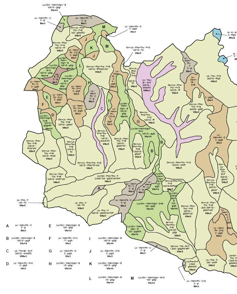
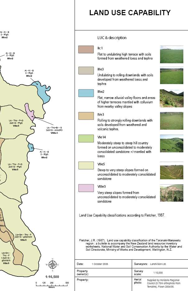
 AUTHORS: The following people were part of the core team responsible for revising, updating and producing the Land Use Capability Survey Handbook 3 rd Edition: - Ian Lynn (Landcare Research) - Andrew Manderson
CHAPTER 3A Environmental Guidelines for STREAM CROSSING BY ALL-TERRAIN VEHICLES
 GOVERNMENT OF NEWFOUNDLAND AND LABRADOR DEPARTMENT OF ENVIRONMENT AND LABOUR CHAPTER 3A Environmental Guidelines for STREAM CROSSING BY ALL-TERRAIN VEHICLES WATER RESOURCES MANAGEMENT DIVISION Water Investigations
Do-Now. 1.) Get out notebook.
 Get out notebook.") Do-Now 1.) Get out notebook. 2.) Answer the following questions on the first clean sheet in your notebook. 1.) What are renewable resources? 2.) What are nonrenewable resources? Alternative Sources of
Do-Now 1.) Get out notebook. 2.) Answer the following questions on the first clean sheet in your notebook. 1.) What are renewable resources? 2.) What are nonrenewable resources? Alternative Sources of
Farming under the Lake Taupo nitrogen cap
 Farming under the Lake Taupo nitrogen cap - Can native plantings help? Roger MacGibbon Lake Taupo has a problem! Lake Taupo has very high water quality, BUT: Monitoring has shown a steady increase in nitrogen
The Social Cost of Road Crashes and Injuries 2013 update
 The Social Cost of Road Crashes and Injuries 2013 update ANNUAL UPDATE NOVEMBER 2013 Prepared by Financial, Economic and Statistical Analysis Team, Ministry of Transport ISSN 1173-1370 Technical queries
Post-Wildfire Clean-Up and Response in Houston Toad Habitat Best Management Practices
 Post-Wildfire Clean-Up and Response in Houston Toad Habitat Best Management Practices Purpose The purpose of this document is to provide guidance and recommendations for minimizing potential impacts to
IS Desertification A Reality or Myth? What is desertification?
 IS Desertification A Reality or Myth? What is desertification? Desertification is a process of fertile land transforming into a desert typically as a result of deforestation, drought or improper/inappropriate
GIS Feature Classes For MMTB - Nga Aho Rangahau SFF Project
 Layer ID Layer 1 New Zealand coastline 2 Boundary of the Maniapoto rohe 3 Roads layer from topographic maps 4 Digital elevation model (15m resolution) 5 Hillshade (15m resolution) 6 Landform elements -
Measuring and monitoring soil erosion for soil conservation and soil protection in Israel
 Measuring and monitoring soil erosion for soil conservation and soil protection in Israel Yoram Benyamini Ministry of Agriculture (SERS), Israel / University of Amsterdam, Netherlands benyamin@science.uva.nl
Disclaimer. Technical queries and comments on this report should be referred to:
 Technical queries and comments on this report should be referred to: Financial, Economic and Statistical Analysis Team Ministry of Transport PO Box 3175 Wellington 6140 New Zealand Email: info@transport.govt.nz
February 4, 2011. hoffman.stephen@epa.gov. Report Recommendations and NIPSCO Responses. 4.3 Maintaining and Controlling Vegetation Growth
 February 4, 2011 VIA E-MAIL AND CERTIFIED MAIL #7010 0290 0002 0577 6226 Mr. Stephen Hoffman US Environmental Protection Agency (5304P) 1200 Pennsylvania Avenue, NW Washington, DC 20460 hoffman.stephen@epa.gov
Course Plan Day 1: Introduction and Overview Hydrology & Fluvial Geomorphology Day 2: Fieldwork on the Braid Burn Alan Jones
 Course Plan Day 1: Introduction and Overview Hydrology & Fluvial Geomorphology Alan Jones E:mail: Alan.Jones@ed.ac.uk Water cycle Globally & Locally River shapes and forms River behaviour Closer look at
Watershed Works Manual
 National Rural Employment Guarantee Act Watershed Works Manual DRAINAGE LINE TREATMENT: GABION STRUCTURE Baba Amte Centre for People s Empowerment Samaj Pragati Sahayog September 2006 Drainage Line Treatment:
APPLICATION PROCESS FOR LAND DISTURBING PERMIT
 PREFACE: APPLICATION PROCESS FOR LAND DISTURBING PERMIT The property owner, developer and designated planners and engineers shall review the general development plans and detailed plans of the Local Issuing