MISSOURI RIVER BED DEGRADATION FEASIBILITY STUDY REPORT SYNOPSIS
|
|
|
- Esther Sutton
- 7 years ago
- Views:
Transcription

1 2012 MISSOURI RIVER BED DEGRADATION FEASIBILITY STUDY REPORT SYNOPSIS KANSAS CITY DISTRICT PLANNING CHARETTE NOVEMBER /15/2012
2 Missouri River Bed Degradation Feasibility Study Report Synopsis October 9, 2012 The Report Synopsis has been prepared by the Project Delivery Team (PDT). The Report Synopsis is one of the SMART planning tools and is designed to help the PDT focus on the foundations of the study through the development of specific documents. This synopsis provides key information to the vertical team in preparation for the upcoming re-scoping charette. The document list for the synopsis has been expanded from the original 7 Pieces of Paper to now also include three additional documents; Study Background, Map of Study Area, and Six-step Planning Process. Documents included in this synopsis are as listed below: Study Background Map of Study Area Six-Step Planning Process Problems and Opportunities Objectives and Constraints Evaluation Criteria Key Uncertainties Without-Project Condition Measures Screened Formulated Plans Under Consideration
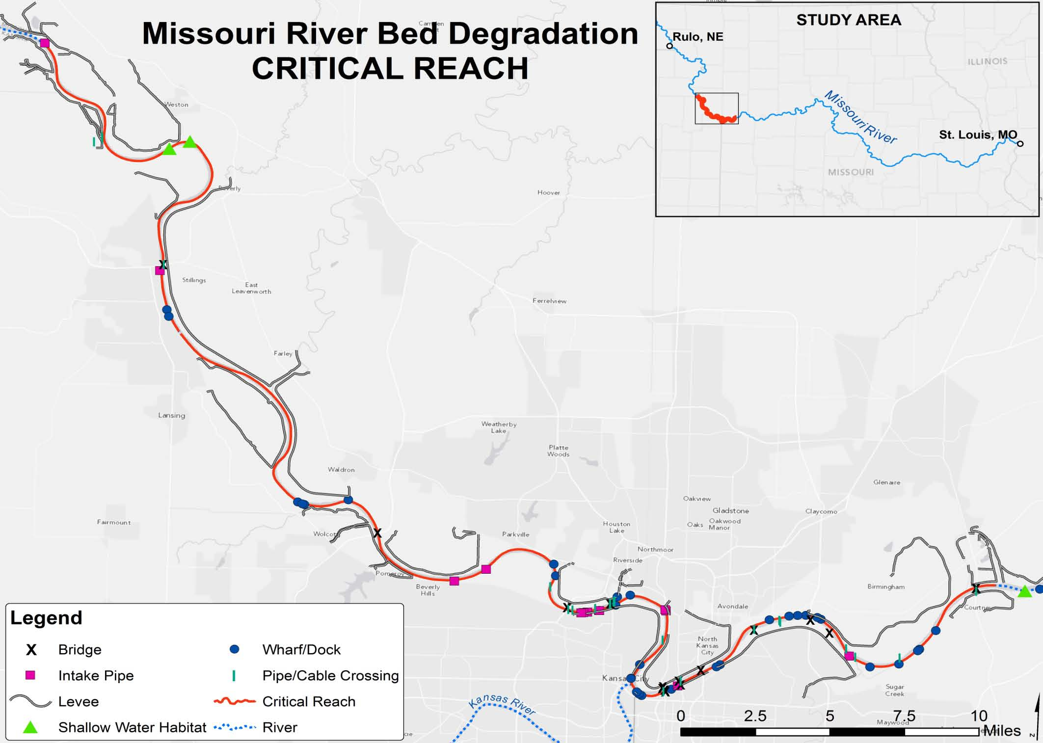
3 Study Background STATUS: The study has completed Planning Step 1, Identify Problems and Opportunities/Objectives and Constraints and is now working on Planning Step 2, Inventory and Forecast Conditions (Existing and Future without Project). AUTHORITY: The study is authorized by Section 216 of Public Law , Flood Control Act of 1970, which reads: The Secretary of the Army, acting through the Chief of Engineers, is authorized to review the operation of projects the construction of which has been completed and which were constructed by the Corps of Engineers in the interest of navigation, flood control, water supply, and related purposes, when found advisable due to significant changed physical or economic conditions, and to report thereon to Congress with recommendations on the advisability of modifying the structures or their operation, and for improving the quality of the environment in the overall public interest. STUDY DESCRIPTION: The study area is located on the lower Missouri River, from River Mile (RM) 498 at Rulo, Nebraska, to the mouth, located north of St. Louis, Missouri. The Missouri River bisects a two-state area. Major cities affected in Missouri are St. Joseph, Kansas City, and Jefferson City. In Kansas, Kansas City and smaller communities adjacent to the Missouri River are affected. The study area also includes tributary rivers and streams where direct influence or effects between the tributary and the Missouri River are evident. Federal projects within the study area include the Missouri River Bank Stabilization and Navigation Project (BSNP) and the associated BSNP Fish and Wildlife Mitigation Project. In addition, there are significant federal Flood Risk Management Infrastructure (Levees and Floodwalls) located throughout the study area. STUDY HISTORY: Reconnaissance Study (b) Analysis: Completed August, 2009 Feasibility Cost Share Agreement (FCSA): Signed November, 2010 Project Management Plan: September, 2011 STUDY COST (as negotiated in FCSA): Total Project Cost estimated at $6.8M. Obligation to date - $1.7M. SPONSOR: Mid-America Regional Council ( MARC) - A regional planning agency that facilitates engagement and funding by a stakeholder group comprised of 17 entities representing a wide range of interests; including water supply, transportation (rail and highway), levee districts, commercial dredging, city, county, and state governments. SCHEDULED LEGACY MILESTONES: (AS REFLECTED IN CURRENT SCHEDULE) Feasibility Scoping Meeting Nov 2013 Alternative Formulation Briefing December 2015 Civil Works Review Board January 2017
4
5 Six Step Planning Process Planning Step 1: Identify Problems and Opportunities/Objectives and Constraints Planning Step 2: Inventory and Forecast Conditions (Existing and Future Without Project) Planning Step 3: Formulate Alternative Plans Planning Step 4: Evaluate Alternative Plans Planning Step 5: Compare Alternative Plans Planning Step 6: Select the Recommended Plan The study is currently in the Inventory and Forecast phase (Step 2) of the planning process as outlined in the Economic and Environmental Principles and Guidelines for Water and Related Land Resources Implementation Studies (1983). Step 1: Specification of Problems and Opportunities has been completed by the study team, which is currently developing without-project conditions. An inventory of at-risk infrastructure and habitats is currently being conducted and is near completion. The following ongoing analyses are in various stages of execution, which will be used to forecast without and with-project conditions: Mobile Bed Model, which forecasts bed elevations and associated river stages, has been built and calibrated. Engineers are currently assembling future conditions for use in the model; Levee Assessments for under seepage and stability are completed for existing conditions and for initial sensitivity assessments of various future conditions; Assessment of design, repair history, and current conditions of the Bank Stabilization and Navigation Project (BSNP) is under peer review; Assessments of infrastructure other than levees (Bridges and Water/Intakes) is underway; USGS regional ground water model, which forecasts ground water conditions at various bed elevations and associated river stages, has been calibrated for existing conditions. The model will be utilized for assessment of impacts under future conditions; Economic Damages Framework is being developed for future costs of operations, maintenance, repair, and replacement for at risk infrastructure; Draft Environmental Baseline Study of affected environment with gap analysis is under review; and Stakeholder engagement with project development occurs at monthly meetings. Public scoping and agency scoping has not been conducted.
6 Problems and Opportunities Problem Statement: Bed degradation in the Missouri River and tributaries impacts critical federal, municipal, and private infrastructure. Lower bed elevation (and the associated river profiles) and low flow stages impose substantial costs on infrastructure owners and operators and affect floodplain ecosystem functionality. Within the study area, located from Rulo, NE to the mouth in St. Louis, MO the bed degradation has been characterized into categories of no-bed change, significant, severe, and critical, based on the drop in the low flow water surface profiles ( ). Based on this characterization the Kansas City Reach (RM 357 to RM 410) was designated as being critical and severe and is the focus of the analysis. In-water and stream bank infrastructure are affected by lower river profiles and stages, which result from bed degradation. Lower river bed elevations impact the structural stability of in-water and stream bank infrastructure. Infrastructure, such as bridges, utility crossings, and flood risk management structures, has been modified to maintain structural integrity with a lower river bed. Lower river stages impact the effectiveness of water intakes, some of which have been modified to operate at lower water surface elevations. Lower river stages reduce groundwater elevations, which impacts alluvial well-field water supply production. Shallow water riverine habitats and floodplain wetlands are also impacted by lower water elevations. In addition, reduced water surface elevations on the lower Missouri River also cause bed degradation on tributaries, creating similar effects to tributary in-water and stream bank infrastructure and habitats. Bed degradation is projected to continue into the future, further lowering Missouri River and tributary bed profiles and river stages. The characterization of the degradation reaches throughout the study region may change due to the impacts from the recent flood of Post flood information is still being processed. Opportunity Statement: The study investigates opportunities on the main stem and tributaries to: Improve federal flood risk management, water supply, and navigation project operations, effectiveness, and efficiencies; Provide ancillary benefits to commercial, industrial, and municipal users of river resources; Bring the Missouri River and tributaries into a more stable balance with current and projected future conditions; Enhance water supply reliability during low flow conditions; Enhance and/or sustain ecosystem functions and services; and Reduce the risk of failure for in-water and stream bank structures. The federal interest in this project is the potential contribution to National Economic Development, which would result from avoiding future damages due to the impacts of bed degradation in the lower Missouri River main stem and tributaries. Future damages include repair and replacement costs for at-riskinfrastructure, which is owned and maintained by federal, state, and local governments, and by private entities. In addition, bed degradation increases BSNP maintenance and operations costs and impacts Missouri River main stem dam project operation (e.g. discretionary releases for downstream municipal water supply).
7 Objectives and Constraints Study Objectives 1 : The objective of the study is to identify a plan which contributes to national economic development by: Reducing future repair and replacement costs for in-water and stream bank infrastructure; Reducing future operations and maintenance costs for in-water and stream bank infrastructure, flood plain habitats, and shallow water habitats; Reduce the negative environmental impacts of bed degradation in the main stem Missouri River and tributaries; Improve infrastructure reliability and reduce risk of failure; and Reverse bed degradation (bed aggradation) where beneficial. Categories of at-risk infrastructure along the 53 river miles identified for detailed investigation in this analysis include: BSNP bank stabilization component (federal); Power utility water intakes (multiple public utilities); Pipelines (multiple private owners); Levees (multiple federal and local projects); Roadway bridges (multiple public agencies); Railway bridges (multiple private owners); Municipal water supply (multiple public agencies); and Critical shallow water habitat (federally implemented). The study objectives may change with future public scoping and National Environmental Policy Act (NEPA) considerations. Study Constraints 2 : Do not implement measures which would impact the Missouri River System s ability to meet all authorized project purposes (flood control, navigation, water supply, recreation, hydropower, fish and wildlife, and irrigation); Do not implement measures which would require system operations that are inconsistent with the Master Manual; and Do not reduce habitat area required by the 2000 Biological Opinion (BiOp) as amended (2003). 1 An objective is a statement of the intended purpose of the planning process; it is a statement of what an alternative plan should try to achieve Charlie Yoe and Kenneth Orth, Planning Manual. IWR Report 96-R-21 (page 79). 2 Planning objectives are the things we want to accomplish with a plan In contrast, study specific planning constraints are things we want to avoid doing Ibid. (page 80).
8 EVALUATION CRITERIA Objectives Metric 1 Reduce future repair and replacement costs for in-water and stream bank Difference between without and with-project projected average annual infrastructure. equivalent value of repair and replacement costs. 2 Reduce future operations and maintenance costs for in-water and stream bank Difference between without and with-project projected average annual infrastructure, flood plain habitats, and shallow water habitats. equivalent value of operations and maintenance costs. 3 Reduce the negative environmental impacts of bed degradation in the main stem Projected acres of suitable habitat: Note that same metric will be used to Missouri River and tributaries. ensure compliance with Constraint #3 (Biop constraint) 4 Improve infrastructure reliability and reduce risk of failure. Probability of levee failure modeling results, first year critical bed elevation and associated profile results from Mobile Bed Model, first year low flow critical water level elevation results from Mobile Bed Model. 5 Reverse bed degradation (bed aggradation) where beneficial. Constraints Projected bed elevations (and associated river profiles). Metric 1 Do not implement measures which would impact the Missouri River System s Proposed changes to release schedules (CFS) ability to meet all authorized project purposes 2 Do not implement measures which would require system operations that are Proposed changes to release schedules (CFS) inconsistent with the Master Manual 3 Do not reduce habitat area required by the 2000 Biological Opinion as Projected acres of suitable habitat amended (2003) COMPARISON CRITERIA Objectives 1, 2, and 4 can be combined into a single dollar value Habitat acres (Objective 3) can be combined into a single value, which assumes that all habitat types are weighted equally More aggradation (Objective 5) is better than halting degradation, but only to the extent that the incremental addition to aggradation generates incremental increases in economic and environmental benefits Note that improved reliability and risk reduction (Objective 4) may also be applied as a threshold creierion for preliminary screening (e.g. a plan may be advanced for detailed analysis only if reliability is improved). SELECTION CRITERIA Use a hierarchy of objectives, such as Dollar value is the primary objective; habitat acres is the secondary objective; and total aggradation is the tertiary objective. Under the hierarchical scenario, the alternative plan with the highest dollar value (net benefits) would be the selected plan. If there were two plans with the same dollar value, then (out of those two plans) the plan with the most habitat acres would be selected, and so on. ADDITIONAL SELECTION CRITERIA: May be used for preliminary screening or detailed analysis P&G Criteria: Effectiveness, Efficiency, Completeness, Acceptability; Reduce loss of life; and Remaining P&G accounts: Regional Economic Development (RED) and Social Effects; Constructability; Improve public safety.
9 KEY UNCERTAINTIES: WHAT AREAS OF UNCERTAINITY DO YOU EXPECT TO IMPACT YOUR PLANNING DECISION? Existing Condition Uncertainty Responsibility for causes of historical degradation Responsibility information would not be available to support cost share decision making Determining responsibility would be expensive, time consuming, and potentially challenging to constraints Responsibility determination would not affect study recommendation Without and With-Project Uncertainty Projected bed degradation (mobile bed model output)--river profiles and stages (over and/or under estimate) Projected bed degradation (mobile bed model output) timing of physical impacts (high and low flow events) Projected bed degradation relation between main stem and tributaries Over and/or under estimation of river profiles and stages would lead to over or underestimation of risks and benefits Sensitivity analyses may be conducted to assess impacts on study recommendation Incorrectly projecting the timing of bed degradation would cause over or under estimation of project benefits Sensitivity analyses may be conducted to assess impacts on study recommendation The relationship between main stem bed degradation and tributary bed degradation is not quantified Professional judgment will be a major factor in projecting tributary bed degradation Over/under estimation of tributary bed degradation will cause over/under estimation of risks and benefits Sensitivity analyses may be conducted to assess impacts on study recommendation Critical bed elevations for in-water and stream Estimates of critical bed elevations will be required for infrastructure that does not have bank infrastructure supporting engineering data Incorrect critical bed elevation estimates will cause an over/under estimation of risks and benefits Sensitivity analyses may be conducted to assess impacts on study recommendation Future OMR&R costs Future OMR&R costs will be based on a combination of historical costs and professional judgment Incorrect future OMR&R costs estimates will cause an over/under estimation of benefits Sensitivity analyses may be conducted to assess impacts on study recommendation Regulatory decisions uncertainty Concerning quantity of commercial dredging (Section 404 permit) Section 401 State Water Quality Certification for chute construction (floodplain connections) USACE Planning decision uncertainty Upper basin water supply decisions (reallocation study) Cottonwood management plan implementation Regional Economic Impact effects on acceptability Potential impacts to dredging, construction, and navigation industries Navigation industry engagement Potential response to BSNP operational changes Navigation industry as a whole is currently not involved with the study
10 Without-Project Condition The without-project condition is currently under development and is not fully formulated. Major components of the without-project condition include: Continued operation and maintenance of the BSNP at current levels; Continuation of commercial sand and gravel dredging activities (level of dredging to be determined); Continued compliance with the 2000 BiOp as amended in 2003; Continued Missouri River bed degradation: Mobile Bed Model projects without-project future bed elevations, river profiles, and river stages; Continued tributary bed degradation: Without-project future bed elevations, river profiles, and river stages in the tributaries will be projected from Missouri River Mobile Bed output; Infrastructure will continue to be at risk and require repairs and replacement: Without-project damages will be projected from Mobile Bed Model output and economic model. Without-project levee reliability will be projected from levee underseepage and stability analyses; and Wetland and shallow water habitats will be affected by lower river stages: Mobile Bed Model output, USGS regional ground water model, and mapping of existing habitats will be used to project at-risk habitats.
11 Measures Screened Measures have not been formulated, however; the district has operated the BSNP for decades, which provides substantial insight into the development of measures. Measures may be screened by the Mobile Bed Model, which is capable of projecting the effects on Missouri River bed degradation resulting from changes in the following factors: Sediment volume; Dredging; Roughness; Cross-sectional geometry; and Bed stabilization. A decision needs to be made concerning the level of detail required to perform screening of measures during plan formulation. More detailed analyses may be required for the evaluation of alternative plans. Additional model development may be required for the analysis of specific alternatives.
12 Formulated Plans Under Consideration There are no formulated plans under consideration at the time.
Tres Rios del Norte Feasibility Study
 Tres Rios del Norte Feasibility Study Santa Cruz River Pima County, Arizona February 2011 Study Area: 18 Miles of Santa Cruz River (Prince to Sanders), portions of City of Tucson, Town of Marana, and unincorporated
LR 314 Working Group 5 Final Report
 LR 314 Working Group 5 Final Report I. Nebraska Department of Natural Resources Table 1. NDNR and NATURAL RESOURCES COMMISSION WATER/INTEGRATED MANAGEMENT PLANNING RELATED RESEARCH, STUDIES AND RELATED
US Army Corps of Engineers Authorities and Programs
 US Army Corps of Engineers Authorities and Programs Section 206; Flood Plain Management Services Program Section 22; Planning assistance to States General Investigations (large-scale flood risk reduction)
Civil Works - FY 2015 CROmnibus & FY 2016 Budget
 Civil Works - FY 2015 CROmnibus & FY 2016 Budget Mark L. Mazzanti Chief, Programs Integration Division Civil Works Directorate, HQUSACE US Army Corps of Engineers BUILDING STRONG 1 BUILDING STRONG USACE
Flood Risk Management
 Flood Risk Management Value of Flood Risk Management Every year floods sweep through communities across the United States taking lives, destroying property, shutting down businesses, harming the environment
Flood Risk Management
 Flood Risk Management Value of Flood Risk Management Value to Individuals and Communities Every year floods sweep through communities across the United States taking lives, destroying property, shutting
U.S. Army Corps of Engineers Tulsa District
 U.S. Army Corps of Engineers Tulsa District Mike Abate, PMP. Chief, Civil Works Branch, PPMD April 17, 2015 US Army Corps of Engineers Civil Works Mission Water Supply 50% of Corps water supply contracts
Upper Des Plaines River & Tributaries, IL & WI Feasibility Study
 Upper Des Plaines River & Tributaries, IL & WI Feasibility Study Jeffrey Zuercher Project Manager Chicago District February 19, 2014 Study Partnership: US Army Corps of Engineers Agenda Background Study
US Army Corps of Engineers Los Angeles District. Rio Salado Oeste Salt River-Phoenix, Arizona FEASIBILITY REPORT SUMMARY
 US Army Corps of Engineers Los Angeles District Rio Salado Oeste Salt River-Phoenix, Arizona FEASIBILITY REPORT SUMMARY U.S. Army Corps of Engineers South Pacific Division, Los Angeles District September
United States Army Corps of Engineers, Civil Works
 United States Army Corps of Engineers, Civil Works Fiscal Year 2013 Federal Program Inventory May 2013 Table of Contents Introduction... 2 Program Inventory... 3 1. Navigation... 3 2. Flood Risk Management...
Oklahoma Governor s Water Conference
 Oklahoma Governor s Water Conference COL Michael Teague District Commander Tulsa District US Army Corps of Engineers 27 October 2010 US Army Corps of Engineers Tulsa District Over 600 people Arkansas River
DRAFT SOUTH FORK SKYKOMISH RIVER
 DRAFT SOUTH FORK SKYKOMISH RIVER 9 levees and revetments / Approximately 1.1 miles of river bank are armored Revetments provide limited, localized erosion protection, but impact habitat Frequent and costly
COMMUNITY CERTIFICATIONS
 National Flood Insurance Program Community Rating System COMMUNITY CERTIFICATIONS Public reporting burden for this form is estimated to average 4 hours for annual recertification, per response. The burden
AN INITIATIVE TO IMPROVE
 L OW E R C A R M E L R I V E R A N D L AG O O N F L O O D P L A I N R E S TO R AT I O N A N D E N H A N C E M E N T P R O J E C T AN INITIATIVE TO IMPROVE FLOOD PROTECTION RESTORE AND PROTECT RIPARIAN
Plan Groundwater Procurement, Implementation and Costs, prepared for the Brazos River Authority, July 2005.
 6 Conjunctive Use 6.1 Lake Granger Augmentation 6.1.1 Description of Option Rapid population growth and development in Williamson County require additional water supplies throughout the planning period.
The Hydrologic Engineering Center Training Course on
 The Hydrologic Engineering Center Training Course on SEDIMENT TRANSPORT ANALYSIS WITH HEC-RAS Davis, California Course Objectives This course is intended to prepare engineers to perform studies using various
US Army Corps of Engineers BUILDING STRONG
 Fort Worth District Public Meeting 20 August 2013 US Army Corps of Engineers Lewisville Dam - Authorization Authorized by the River and Harbor Act, approved 2 March 1945 (Public Law 14, 79th Congress,
LEAGUE NOTES ON APPROVED COMMUNITY WATER SUPPLY PLAN
 1 AUGUST 2011 LEAGUE NOTES ON APPROVED COMMUNITY WATER SUPPLY PLAN KEY ELEMENTS OF THE PLAN: 1. Replace the existing unsafe Ragged Mountain dam with a new dam and raise the reservoir pool level initially
QUESTIONS AND ANSWERS WATERS OF THE U.S. PROPOSAL
 QUESTIONS AND ANSWERS WATERS OF THE U.S. PROPOSAL Key Background Congress enacted the modern Clean Water Act in 1972 to address pollution entering the nation s waters to complement statutes such as the
Assessment of Conceptual Nonstructural Alternative Levee Setbacks along the Missouri River (Lower L-575 / Upper L-550 and Lower L-550)
") Assessment of Conceptual Nonstructural Alternative Levee Setbacks along the Missouri River (Lower L-575 / Upper L-550 and Lower L-550) Final Report April 2012 Executive Summary The authorities of Public
Assessment of Conceptual Nonstructural Alternative Levee Setbacks along the Missouri River (Lower L-575 / Upper L-550 and Lower L-550) Final Report April 2012 Executive Summary The authorities of Public
PROPOSED REHABILITATION SAN CARLOS IRRIGATION PROJECT FACILITIES. Pinal County, Arizona. Scoping Information and Opportunity to Comment
 PROPOSED REHABILITATION SAN CARLOS IRRIGATION PROJECT FACILITIES Pinal County, Arizona Scoping Information and Opportunity to Comment U.S. Department of the Interior Bureau of Reclamation Phoenix Area
Methods for Determination of Safe Yield and Compensation Water from Storage Reservoirs
 US Army Corps of Engineers Hydrologic Engineering Center Methods for Determination of Safe Yield and Compensation Water from Storage Reservoirs October 1966 Approved for Public Release. Distribution Unlimited.
1. INTRODUCTION 5. THE PERMIT PROCESS
 1. INTRODUCTION Laws of the United States and the State of Iowa have assigned the US Army Corps of Engineers and the Iowa Department of Natural Resources with specific and different regulatory roles designed
Appendix A. Lists of Accomplishments and Project Costs. UMRWD 10 Year Plan Update. Appendix A UPPER MINNESOTA RIVER WATERSHED DISTRICT
 UPPER MINNESOTA RIVER WATERSHED DISTRICT Lists of Accomplishments and Project Costs 10 Year Plan Update UMRWD 10 Year Plan Update Page A 1 UMRWD LIST OF ACCOMPLISHMENTS Since its inception in 1967, the
King County Flood Hazard Management Plan Update Cedar/ Sammamish Rivers. Public Meeting December 5, 2012
 King County Flood Hazard Management Plan Update Cedar/ Sammamish Rivers Public Meeting December 5, 2012 Goals of the Presentation Cedar and Sammamish R. Plan Update Context - Brief summary info about the
Hydrologic Engineering Techniques for Regional Water Resources Planning
 US Army Corps of Engineers Hydrologic Engineering Center Hydrologic Engineering Techniques for Regional Water Resources Planning October 1969 Approved for Public Release. Distribution Unlimited. TP-17
Sims Bayou Federal Flood Damage Reduction Project
 Sims Bayou Federal Flood Damage Reduction Project A. Gene Rushing, Jr., P.E., PMP HCFCD Project Manager January 15, 2014 Harris County s Watersheds Historical Flooding in Harris County 1929 1935 HCFCD
This paper provides a concise description of
 13 UNIVERSITIES COUNCIL ON WATER RESOURCES ISSUE 130, PAGES 13-19, MARCH 2005 Overview of Flood Damages Prevented by U.S. Army Corps of Engineers Flood Control Reduction Programs and Activities James J.
Chehalis River Basin Flood Damage Reduction 2013-2015 Capital Budget Approved by Legislature in June 2013
 Chehalis River Basin Flood Damage Reduction 2013-2015 Capital Budget Approved by Legislature in June 2013 1. Design alternatives for large capital flood projects (basinlevel water retention and Interstate
HCP Team Meeting. November 18, 2015. icfi.com
 HCP Team Meeting November 18, 2015 icfi.com 1 Welcome and Introductions Where are we in the HCP process Hydrology modeling update Native fish survey Fish translocation Finalize covered activities Next
PUBLIC NOTICE Application for Permit
 PUBLIC NOTICE Application for Permit 30-Day Notice Issue Date: June 20, 2016 Expiration Date: July 20, 2016 US Army Corps of Engineers No: NWP-2010-535 Oregon Department of State Lands No: 58311-RF Interested
Implementing the Water Resources Development Act of 2007
 Implementing the Water Resources Development Act of 2007 Rich Worthington U.S. Army Corps of Engineers, Headquarters December 5, 2007 WRDA 2007 (PL 110-114 ) PROVISIONS IMPORTANT TO AAPA STATUS: Passed
RE: Docket # COE 2010 0035; ZRIN 0710 ZA05 Submitted via email to NWP2012@usace.army.mil and Rulemaking Portal at www.regulations.gov.
 April 18, 2011 U.S. Army Corps of Engineers Attn: CECW CO R 441 G Street, N.W. Washington, DC 20314 1000 RE: Docket # COE 2010 0035; ZRIN 0710 ZA05 Submitted via email to NWP2012@usace.army.mil and Rulemaking
Lower Raritan Watershed Management Area Stormwater & Flooding Subcommittee Strategy Worksheet LRSW-S3C1
 Strategy Name: Reduce Existing Potential for Flood Damages LRSW-S3C1. Develop and implement a program to: Minimize flood damages through the use of structural measures. Minimize flood damages through the
Laws and Regulatory Requirements to Consider Before You Build a Pond
 Bulletin #2376 Laws and Regulatory Requirements to Consider Before You Build a Pond John M. Jemison, Jr., Extension water quality and soil specialist Donna Lamb, Extension educator Before constructing
https://orm.usace.army.mil/orm2/f?p=106:34:4198546103662037::no::
 Page 1 of 6 APPROVED JURISDICTIONAL DETERMINATION FORM U.S. Army Corps of Engineers JD Status: DRAFT SECTION I: BACKGROUND INFORMATION A. REPORT COMPLETION DATE FOR APPROVED JURISDICTIONAL DETERMINATION
Urban Stream Restoration Defining the Full Benefits of a Project. Warren C. High MACTEC Engineering and Consulting
 Urban Stream Restoration Defining the Full Benefits of a Project Warren C. High MACTEC Engineering and Consulting Economics in the Decision Process Return on Investment Willingness to Pay Municipal Growth
The Basics of Chapter 105 Waterways and Wetlands Permitting in PA
 The Basics of Chapter 105 Waterways and Wetlands Permitting in PA April 17, 2013 Goal To develop a basic understanding of PA Department of Environmental Protection (DEP) and US Army Corps of Engineers
Checklist for Reviewing Technical Programs and Procedures
 Checklist for Reviewing Technical Programs and Procedures Attachment 9 to KQAP A. Soil Survey 1) Does the official soil survey meet the needs of the internal and external customers? 2) Is there a method
Arkansas River Corridor Vision & Master Plan
 A r k a n s a s R I v e r C o r r I d o r P l a n Arkansas River Corridor Vision & Master Plan July 2005 Indian Nations Council of Governments A r k a n s a s R I v e r C o r r I d o r P l a n Partnership
ESRI_UC_2015_No843_Integrating Flood Risk Management and Salmon Habitat Restoration_CampbellSW
 ESRI_UC_2015_No843_Integrating Flood Risk Management and Salmon Habitat Restoration_CampbellSW Advancing an integrated approach to flood risk management and habitat restoration planning in the Puget Sound
Gold Ray Dam Interagency Technical Team Meeting
 Gold Ray Dam Interagency Technical Team Meeting Agenda Public Outreach, Funding, Monitoring EA/BA/Permit Updates Deconstruction Plans Fish Passage & Salvage Plan Hydraulic Modeling Next Steps Public Outreach,
How To Manage Water Resources In The Yakima Basin
 Yakima Basin Integrated Water Resource Management Plan October 23, 2014 Presented by Derek Sandison, Director Office of Columbia River Photo Courtesy of Tom Ring Basin size: 6,155 sq. miles Population:
USACE Civil Works Infrastructure Investment Trends: Glide-Path to Benign Neglect?
 USACE Civil Works Infrastructure Investment Trends: Glide-Path to Benign Neglect? National Waterways Conference Legislative Summit Steven L. Stockton, P.E. Director of Civil Works, U.S. Army Corps of Engineers
ECONOMIC ANALYSIS FLOOD DAMAGE REDUCTION. Lower Carmel River Floodplain Restoration and Enhancement Project
 ECONOMIC ANALYSIS FLOOD DAMAGE REDUCTION Lower Carmel River Floodplain Restoration and Enhancement Project I. Description of the Project and its Relationship to Other Projects in the Proposal The Lower
SIMULATION OF SEDIMENT TRANSPORT AND CHANNEL MORPHOLOGY CHANGE IN LARGE RIVER SYSTEMS. Stephen H. Scott 1 and Yafei Jia 2
 US-CHINA WORKSHOP ON ADVANCED COMPUTATIONAL MODELLING IN HYDROSCIENCE & ENGINEERING September 19-21, Oxford, Mississippi, USA SIMULATION OF SEDIMENT TRANSPORT AND CHANNEL MORPHOLOGY CHANGE IN LARGE RIVER
7.0 Stream Restoration
 7.0 Stream Restoration 7.1 Issue Statements One of the primary concerns of residents in the Bassett Creek watershed is the maintenance of the natural beauty of the creek in residential and recreational
Henry Van Offelen Natural Resource Scientist MN Center for Environmental Advocacy hvanoffelen@mncenter.org
 Henry Van Offelen Natural Resource Scientist MN Center for Environmental Advocacy hvanoffelen@mncenter.org Wetland study slide Water Quality NRE goals in watershed plans Protect habitat that remains.
Wetland Creation and Restoration Cost Factors: U.S. Army Corps of Engineers
 Wetland creation and restoration Wetland Creation and Restoration Cost Factors: A presentation by PATRICIA M. OBRADOVICH 1 Portland District, P.O. Box 2946 Portland, OR 97208-2946 Session Six ABSTRACT
ALTERNATIVE SOURCES OF FUNDING FOR
 November 2015 ALTERNATIVE SOURCES OF FUNDING FOR Flood-Related General Water Management Water Supply Projects The following inventory contains information about a variety of funding programs offered by
Appendix C. Project Opportunities. Middle Twisp River (RM 7.8 18.12)
") Appendix C Project Opportunities Middle Twisp River (RM 7.8 18.12) This table describes project opportunities by project area. Locator maps of the project opportunities are included below the table. Reach
Appendix C Project Opportunities Middle Twisp River (RM 7.8 18.12) This table describes project opportunities by project area. Locator maps of the project opportunities are included below the table. Reach
North Branch Chicago River Watershed-Based Plan
 North Branch Chicago River Watershed-Based Plan EXECUTIVE SUMMARY In Lake County, the Lake County Stormwater Management Commission (SMC) is responsible for managing Lake County s water resources. The North
Distribution Restriction Statement
 CECW-EP Engineer Regulation 1110-2-1150 Department of the Army U.S. Army Corps of Engineers Washington, DC 20314-1000 ER 1110-2-1150 31 August 1999 Engineering and Design ENGINEERING AND DESIGN FOR CIVIL
PEER REVIEW PLAN JANUARY 2008 UPDATE
 PEER REVIEW PLAN Manhattan, Kansas Levee Section 216 FLOOD RISK MANAGEMENT PROJECT FEASIBILITY STUDY JANUARY 2008 UPDATE 1 PEER REVIEW PLAN Manhattan, Kansas Levee Section 216 FLOOD RISK MANAGEMENT PROJECT
4. Environmental Impacts Assessment and Remediation Targets
 4. Environmental Impacts Assessment and Remediation Targets 4.1 Environmental Impacts Significant additional development in the Alder Creek watershed is not anticipated at this time; however, there are
Stream Rehabilitation Concepts, Guidelines and Examples. Objectives. Pierre Y. Julien. Three Laws of Stream Restoration
 Stream Rehabilitation Concepts, Guidelines and Examples Pierre Y. Julien Wuhan 2005 Objectives Part I - Stream restoration and rehabilitation: 1. Present and discuss important concepts, laws, criteria
4.2 Buena Vista Creek Watershed
 Buena Vista Creek Watershed 4.2 Buena Vista Creek Watershed Watershed Overview The Buena Vista Creek Watershed is the fourth-largest system within the Carlsbad Hydrologic Unit. The watershed extends approximately
DISTRICT VALUES STATEMENTS, GOALS, ACTION ITEMS, AND ONGOING TASKS FOR 2015 Adopted by the Board of Directors December 10, 2014. Values Statements.
 DISTRICT VALUES STATEMENTS, GOALS, ACTION ITEMS, AND ONGOING TASKS FOR 2015 Adopted by the Board of Directors December 10, 2014 Values Statements. The Board opposes any new transfers of water from the
Interim Technical Guidelines for the Development of Environmental Management Plans for Underground Infrastructure Revised - July 2013.
 Interim Technical Guidelines for the Development of Environmental Management Plans for Underground Infrastructure Revised - July 2013 Rationale Underground infrastructure may be at risk from valley, streambank
A. Flood Management in Nevada
 Nevada Division of Water Planning A. Flood Management in Nevada Introduction Flooding has been a concern for Nevada communities since the first settlers moved to the territory in the mid-1800 s. Fourteen
Swannanoa River Flood Risk Management Study
 Swannanoa River Flood Risk Management Study Measures Evaluated to Reduce Future Flood Damages City of Asheville U.S. Army Corps of Engineers Flooding History Part of the 132 square mile Swannanoa River
Final Independent External Peer Review Report of the Rio Grande de Arecibo, Puerto Rico Post Authorization Change Limited Reevaluation Report
 Final Independent External Peer Review Report of the Rio Grande de Arecibo, Puerto Rico Post Authorization Change Limited Reevaluation Report Prepared by Battelle Memorial Institute Prepared for Department
A9. Flood Damage Reduction
 A9. Flood Damage Reduction Attachment 9 identifies the flood damage reduction benefits attributed to the seven projects proposed for implementation in the Santa Barbara County Region Proposition 84 (Prop
The Mississippi River & Tributaries Project
 The Mississippi River & Tributaries Project The Mississippi River & Tributaries (MR&T) project was authorized by the 1928 Flood Control Act. Following the devastating 1927 flood, the nation was galvanized
Floodplain Connectivity in Restoration Design
 Floodplain Connectivity in Restoration Design 2015 Symposium on Restoration in a Contaminated Environment: Lessons Learned and Challenges in Moving Forward Part II April 2015 Karin Boyd Applied Geomorphology,
St. Vrain Watershed Master Plan Thursday, January 23 10:00 a.m. 12:15 p.m.
 St. Vrain Watershed Master Plan Thursday, January 23 10:00 a.m. 12:15 p.m. City Council Study Session Room City of Longmont Civic Center, 350 Kimbark Street, Longmont Minutes 1. Introductions a. Jeff Crane
King County, Washington Policies and Practice for the Use of Eminent Domain For Flood Risk Reduction
 King County, Washington Policies and Practice for the Use of Eminent Domain For Flood Risk Reduction Introduction Eminent domain refers to the power possessed by the state over all property within the
IUCN Guidelines to Avoid Impacts of Water Resources Projects on Dams and Other Water Infrastructure
 IUCN Guidelines to Avoid Impacts of Water Resources Projects on Dams and Other Water Infrastructure (December 2013) IUCN does not engage in projects which involve the design, construction or rehabilitation
US Army Corps of Engineers Los Angeles District. Santa Cruz River, Paseo de las Iglesias Pima County, Arizona PROJECT SUMMARY
 US Army Corps of Engineers Los Angeles District Santa Cruz River, Paseo de las Iglesias Pima County, Arizona PROJECT SUMMARY U.S. Army Corps of Engineers January 2006 TABLE OF CONTENTS 1.0 STUDY INFORMATION...1
Development of Technical Data For Long Term Flood Solutions For the Red River Basin
 IDENTIFYING WHAT WE DIDN T KNOW Development of Technical Data For Long Term Flood Solutions For the Red River Basin LTFS Study Area U.S. Portion of Red River Basin (MN, ND & SD) Main Stem Red River Tributaries
Flood Plain Reclamation to Enhance Resiliency Conserving Land in Urban New Jersey
 Flood Plain Reclamation to Enhance Resiliency Conserving Land in Urban New Jersey Rutgers Cooperative Extension Water Resources Program Christopher C. Obropta, Ph.D., P.E. Email: obropta@envsci.rutgers.edu
Section 19. Basin-wide Mitigation Action Plans
 Section 19. Basin-wide Mitigation Action Plans This Mitigation Plan identifies twelve specific hazards that could affect the Basin. Section 20 of this Plan set forth mitigation action plans to be carried
DECISION DOCUMENT REVIEW PLAN USING THE NATIONAL PROGRAMMATIC REVIEW PLAN MODEL
 Continuing Authorities Program Section 1135, Water Resources Development Act of 1986, as Amended Project Modifications for the Improvement of the Environment DECISION DOCUMENT REVIEW PLAN USING THE NATIONAL
REVIEW PLAN For FLOOD RISK MANAGEMENT FOR DICKENSON COUNTY PUBLIC SCHOOLS LEVISA FORK BASIN DICKENSON COUNTY, VIRGINIA SECTION 202 NONSTRUCTURAL
 REVIEW PLAN For FLOOD RISK MANAGEMENT FOR DICKENSON COUNTY PUBLIC SCHOOLS LEVISA FORK BASIN DICKENSON COUNTY, VIRGINIA SECTION 202 NONSTRUCTURAL PROJECT Huntington District October 2010 REVIEW PLAN FLOOD
FLOOD PROTECTION AND ECOSYSTEM SERVICES IN THE CHEHALIS RIVER BASIN. May 2010. Prepared by. for the. 2010 by Earth Economics
 FLOOD PROTECTION AND ECOSYSTEM SERVICES IN THE CHEHALIS RIVER BASIN May 2010 Prepared by for the Execubve Summary The Chehalis Basin experienced catastrophic flooding in 2007 and 2009. In response, the
9.1. Adequacy of Available Data and Monitoring Efforts
 9. DATA MANAGEMENT Data management is a crucial aspect of successful implementation of the ARB IRWMP and its component projects. This section discusses the adequacy of available data and monitoring efforts,
HUDSON RIVER-BLACK RIVER REGULATING DISTRICT BOARD MEETING JUNE 10, 2014
 HUDSON RIVER-BLACK RIVER REGULATING DISTRICT BOARD MEETING JUNE 10, 2014 PRESENTATION TOPICS Analysis Objectives Analysis Dam Removal Plan Dam Remediation Plan Effects Analysis Permit Requirements Decision
Eco-Logical Approach to Infrastructure Development Initiative. May 12 & 14, 2010 Eco-Logical Initiative Technical Meeting
 Eco-Logical Approach to Infrastructure Development Initiative May 12 & 14, 2010 Eco-Logical Initiative Technical Meeting East-West Gateway Metropolitan Planning Organization (MPO) 8 County Bi-State Region
The Teton Creek Restoration Project Summary:
 The Teton Creek Restoration Project Summary: The Teton Creek Restoration Project area extends for approximately one mile upstream from the Cemetery Road Bridge and includes the Aspen Pointe, The Aspens
Appendix B REFERENCES
 Appendix B REFERENCES 2007 Field Reconnaissance Report of Bank Erosion Sites and Site Priority Ranking. Sacramento River Flood Control Levees, Tributaries and Distributaries American Red Cross. www.redcross.org
Appendix J Online Questionnaire
 Appendix J Online Questionnaire In accordance with the Paperwork Reduction Act, this questionnaire was approved by the Office of Management and Budget (OMB). The OMB control number and expiration date
Prattsville Berm Removal Project. 1.0 Project Location
 Prattsville Berm Removal Project 1.0 Project Location The project site is located between the New York State Route 23 Bridge over the Schoharie Creek and the Schoharie Reservoir. The restoration plan encompassed
Post-Flood Assessment
 Page 1 of 7 Post-Flood Assessment CHAPTER 4 AGENCY COORDINATION Agency coordination is an essential element for the operation of the flood management systems in the Central Valley. Due to the nature of
EFFECTS OF ARUNDO DONAX ON RIVER HYDRAULICS, SEDIMENT TRANSPORT, AND GEOMORPHOLOGY, SANTA MARGARITA RIVER, CALIFORNIA
 EFFECTS OF ARUNDO DONAX ON RIVER HYDRAULICS, SEDIMENT TRANSPORT, AND GEOMORPHOLOGY, SANTA MARGARITA RIVER, CALIFORNIA René Leclerc Geomorphologist Robert C. MacArthur, Ph.D., P.E. Principal Headwaters
BRIDGE SCOUR INVESTIGATION: DEVELOPING A SCREENING AND HYDRAULIC VULNERABILITY RATING SYSTEM FOR BRIDGES B.HERON 1 & C.BOWE 2
 BRIDGE SCOUR INVESTIGATION: DEVELOPING A SCREENING AND HYDRAULIC VULNERABILITY RATING SYSTEM FOR BRIDGES B.HERON 1 & C.BOWE 2 1 O Connor Sutton Cronin Consulting Engineers, Dublin, Ireland 2 Iarnród Éireann,
Appendix F Benefit-Cost Analysis of Flood Protection Measures
 Appendix F Benefit-Cost Analysis of Flood Protection Measures Acronyms used in Appendix F: AA B AA C AA D BC BFE EAD FEMA NED O&M PV RED USACE Average Annual Benefits Average Annual Cost Average Annual
Greater Los Angeles County Region
 Attachment 6 Greater Los Angeles County Region IRWM Implementation Grant Proposal Monitoring, Assessment, and Attachment 6 consists of the following items: Monitoring, Assessment, and. The purpose of this
Channel Maintenance Management Plan
 Channel Maintenance Management Plan Upper Mississippi River Navigation System St. Paul District 1.0 Project Location And Description. The St. Paul District is responsible for maintaining various navigation
River Restoration Activities in the Rio Grande Canalization Flood Control Project. Upper Rio Grande Citizens Forum Elizabeth Verdecchia July 19, 2012
 River Restoration Activities in the Rio Grande Canalization Flood Control Project Upper Rio Grande Citizens Forum Elizabeth Verdecchia July 19, 2012 Rio Grande Canalization Flood Control Project Canalization
Prioritizing Wetland and Stream Restoration and Protection Using Landscape Analysis Tools
 Prioritizing Wetland and Stream Restoration and Protection Using Landscape Analysis Tools The Environmental Law Institute recently completed A Handbook for Prioritizing Wetland and Stream Restoration and
1.7.0 Floodplain Modification Criteria
 1.7.0 Floodplain Modification Criteria 1.7.1 Introduction These guidelines set out standards for evaluating and processing proposed modifications of the 100- year floodplain with the following objectives:
Klamath Tracking and Accounting Program Vision
 Klamath Tracking and Accounting Program Vision September 2010 The Klamath Basin Water Quality Improvement Tracking and Accounting Program (Klamath TAP) is being developed to support Klamath Basin restoration
Water Security Agency. Plan for 2015-16. saskatchewan.ca
 Water Security Agency Plan for 2015-16 saskatchewan.ca Statement from the Minister I am pleased to present the Water Security Agency s Plan for 2015-16. The Honourable Scott Moe Minister Responsible for
Mission Reach Self-Guided Tour Mission Concepción Portal Loop and Mission Reach Phase II Embayment Loop
 Mission Reach Self-Guided Tour Mission Concepción Portal Loop and Mission Reach Phase II Embayment Loop Welcome to the Mission Reach! The Mission Reach Ecosystem Restoration and Recreation Project is transforming
Flood Damage Prevention in Delaware County, NY
 Flood Damage Prevention in Delaware County, NY Susquehanna Basin 2 Villages, 8 Hamlets Schoharie Basin 1 Hamlet Cannonsville Basin 4 Villages, 6 Hamlets Pepacton Basin 2 Villages, 6 Hamlets Upper Delaware
Wreck Pond Watershed Management Study. Project Management Plan. New York District U.S. Army Corps of Engineers
 Wreck Pond Watershed Management Study Project Management Plan New York District U.S. Army Corps of Engineers May 2011 Table of Contents CHAPTER I. INTRODUCTION 3 CHAPTER II. BACKGROUND: SECTION 905(B)
Emergency Streambank Restoration/Stabilization. Kentucky Division of Water Water Quality Certification May 2010 Educational Assistance
 Emergency Streambank Restoration/Stabilization Kentucky Division of Water Water Quality Certification May 2010 Educational Assistance Due to the severity of the recent rains and flooding occurrences, the
Mouth of the Columbia River Jetties Major Rehabilitation Study
 Mouth of the Columbia River Jetties Major Rehabilitation Study PNWA Port of Vancouver January 29, 2010 US Army Corps of Engineers Project Overview Background Corps Guidance for Major Rehab Project Alternatives
Thank you to all of our 2015 sponsors: Media Partner
 Thank you to all of our 2015 sponsors: Media Partner Channel Naturalization: Planning and Implementation in Peel Region TRIECA March 25 & 26, 2015 Peel Region Channel Remediation Strategy An Urban Context
INFORMATION SHEET ORDER NO. R5-2011-XXXX TRIANGLE ROCK PRODUCTS, INC. FLORIN ROAD AGGREGATE PLANT SACRAMENTO COUNTY
 ORDER NO. R5-2011-XXXX INFORMATION SHEET Background Triangle Rock, Inc. (Discharger) submitted a Report of Waste Discharge (RWD) on 23 August 2010. The Discharger is expanding the mining operations at