Evolution of the Global Observing System: a Vision for John Eyre and Jérôme Lafeuille Met Office, UK WMO
|
|
|
- Bethanie Banks
- 7 years ago
- Views:
Transcription
1 Evolution of the Global Observing System: a Vision for 2025 John Eyre and Jérôme Lafeuille Met Office, UK WMO ITSC-16, Angra dos Reis, Brazil; 7-13 May 2008
2 Evolving the Global Observing System (GOS) of WMO User requirements Observing system capabilities Statement of Guidance = GAP ANALYSIS Implementation Plan Vision for the GOS


3 The future GOS globally co-ordinated built on existing components, both surfaceand space-based capitalise on existing and new observing technologies increasing role of space leading to improved data, products and services from NMHSs
4 Vision for the GOS in 2025 Content: Document currently in draft General trends and issues Space-based component operational geo operational sun-synchronous leo additional operational R&D capability Surface-based component
5 General trends and issues Response to user needs Integration - WIGOS Expansion Automation Consistency and homogeneity
6 Space-based GOS: current Vision to operational GEOs, all with multi-spectral imager (IR/VIS); some with hyper-spectral sounder (IR) 4 operational LEOs optimally spaced in time, all with multi-spectral imager (MW/IR/VIS/UV), all with sounder (MW), 3 with hyper-spectral sounder (IR), 2 with altimeter, 3 with conical-scan MW or scatterometer Several R&D satellites: constellation of small satellites for radio occultation (RO), LEO with wind lidar, LEO with active and passive microwave precipitation instruments, LEO and GEO with advanced hyper-spectral capabilities, GEO lightning Improved inter-calibration and operational continuity


7 Space-based component of the GOS
8 Proposed developments of space-based GOS under the draft Vision for 2025 Main themes: Optimize current geostationary constellation Optimize current sun-synchronous orbit sounding missions Implement operational radio occultation sounding constellation Review ocean altimetry observation strategy Refine ocean surface wind vector observation strategy Make additional missions operational, e.g. for GCOS ECVs
9 Optimizing the geostationary constellation Current nominal locations : 135 W, 75W, 0, 76 E, 105 E, 140 E Footprints for a maximum zenith angle < 70 deg Latitude Longitude
10 Optimizing the geostationary constellation Recommendation: at least 6 satellites separated by < 60 longitude with multispectral imager & hyperspectral IR sounder Latitude Longitude
11 IR hyperspectral sounding from geo orbit Current plans of satellite operators: MTG / IRS (2018) FY-4 O / IIS (2016) GOES-R series / HES, under consideration after GOES-S MTSAT-FO / Sounder, under consideration by JMA-JAXA GIFTS: prototype instrument was proposed for a demo mission in as part of IGeoLab cooperation concept
12 Current baseline Optimizing sun-synchronous IR/ MW sounding missions LST: 18h Large gap near dawn-dusk Afternoon orbits North pole LST: 00h LST: 12h Morning orbits LST: 06h
13 Optimizing sun-synchronous IR/ MW sounding missions Northern Hemisphere LST: 18h New recommended baseline LST: 00h LST: 12h LST: 06h
14 Optimizing sun-synchronous IR/ MW sounding missions Recommended baseline with inorbit redundancy LST: 00h LST: 12h
15 Radio occultation sounding Complementary to passive IR/MW sounding High number of satellites needed to meet coverage and observing cycle requirements at least 6 satellites optimal configuration TBD (including OSSEs) constellation with several clusters / orbits Scope for international cooperation
16 Transition of R&D missions to operations Concept Experiment Demonstration Operational technology Technology readiness Salinity New Soil moisture Gravity field Geoid ERB Research purpose Vegeta missionstion New Ozone aerosols Ocean colour Sea Surface wind Precipita -tion rate Ocean Altimetry Technology purpose Wind missions Lidar ROS IR/MW sounding OPERATIONAL VIS/IR imagery MISSIONS Clouds & AMV No continuity Long-term operational commitment continuity
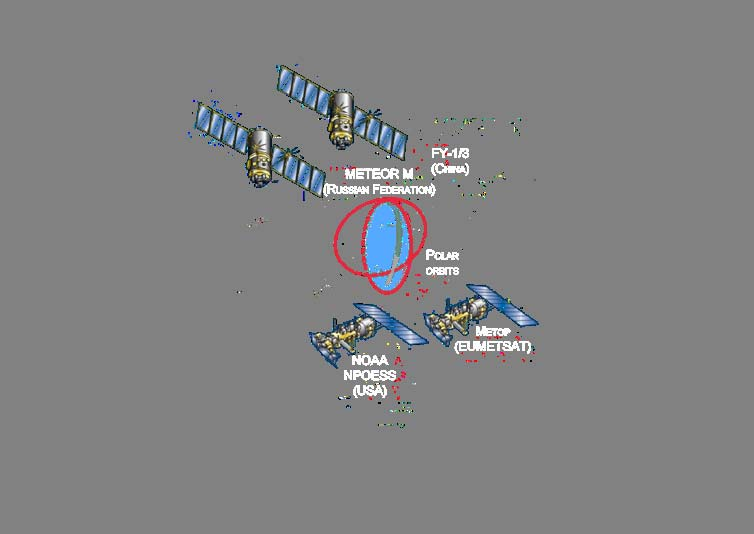
17 Vision for the space-based GOS in 2025: Summary (1) At least 6 operational geostationary satellites: All with IR/VIS multi-spectral imager All with IR hyper-spectral sounder With no more than 60 longitude difference between neighbouring locations Operational polar-orbiting sun-synchronous satellites on 3 orbital planes: All with IR/VIS multi-spectral imager All with MW sounder All with IR hyper-spectral sounder
18 Vision for the space-based GOS in 2025: Summary (2) Additional operational missions in appropriate orbits: 2 sun-synch. sats with scatterometer 2 sun-synch. sats with conically-scanning polarimetric MW imager 2 sun-synch. sats with narrow-band VIS/NIR imagers for ocean colour + veg. Constellation of high-resolution VIS/IR imagers for land surface imaging Constellation for radio occultation Constellation for altimetry: 2 in sun-synch orbits and 1 high-precision ref. Constellation of LEO satellites for precipitation measurements: combined use of active instrument in low-inclination orbit and passive microwave instruments in several high-inclination orbits Constellation of sensors for Earth radiation budget: including at least 1 broadband multi-angle viewing radiometer in LEO, and 1 total solar irradiance sensor, together with auxiliary LEO measurements and geo sensors Constellation of instruments/missions to address atmospheric composition
19 Vision for the space-based GOS in 2025: Summary (3) Several R&D satellites and operational pathfinders including: LEO with Doppler wind lidar LEO Low-frequency MW radiometer addressing salinity and soil moisture GEO microwave Considered as optional: Satellites in highly elliptical orbit (HEO) ensuring polar region coverage Geostationary lightning detection Improved availability, timeliness, and intercalibration through operational cooperation among agencies.
20 Developing a new Vision who s involved? WMO Expert Team on Evolution of the GOS (requirements for space+surface obs) ET on Satellite Utilization & Products ET on Satellite Systems ET on Automatic Weather Stations Implementation/Coordination Team on Integrated Observing Systems (ICT-IOS) Commission for Basic Systems (CBS) Optimization workshops CGMS CEOS Other stakeholders
21 Developing a new Vision schedule July 2007 Dec 2008 Discussion of draft within WMO Expert Teams and with other stakeholders *** COMMENTS WELCOME! *** Early 2009 Adoption by WMO Commission for Basic Systems

22 Thank you for your attention
23 Ocean surface topography The community (including CEOS Ocean Surface Topography Constellation) has recommended 2 components: One high-precision reference altimeter system with orbit and coverage avoiding tidal aliasing (e.g. Jason) Two complementary altimetry systems on higher inclination orbits to maximize global coverage (e.g. GFO, ENVISAT or Sentinel-3 ) covering from oceanic mesoscale to basin-wide scale and addressing ocean weather and climate applications
24 Ocean surface wind vector 2 scatterometers 2 full-polarization MW imagers other MWI (dual polarization) contribute to additional wind speed data
25 New missions required on long-term basis for GCOS ECVs Global precipitation measurement (GPM concept) Earth Radiation Budget (to be refined) TSI and TOA upcoming SW-LW Contextual parameters (cloud, aerosols, WV) Geostationary multi-spectral imagery for diurnal cycle Atmospheric composition constellation (to be refined) for O3, GHG, aerosols, and air quality in lower troposphere Specific imaging missions for ocean colour and vegetation
26 Vision of the GOS to 2025 Forward looking but affordable Serving broader objectives - step towards WIGOS Enhanced and diversified capabilities More commitments to long-term continuity Requires more resources Possible with wider community of GOS contributors Need enhanced cooperation to optimize global effort Ensuring data exchange and consistent data quality
27 References User Requirements from CEOS-WMO database Statements of Guidance Gap Analysis presented at the WMO Workshop on Re-design and Optimization of the GOS and at CGMS-XXXV


28 Evolution of the GOS Responding to evolving requirements Vision of the GOS Manual on the GOS High-level definition of the space-based GOS Identification of implementation actions/recomm WMO Implementation Plan for GOS CGMS actions CEOS Constellations and Implem.Plan Gap analysis Statement of Guidance Members Space Agencies programmes Rolling Requirements Review
29 Evolution of the GOS Updating the long-term vision Rolling Requirements Review Gap analysis Statement of Guidance Identification of implementation actions/recomm Members Space Agencies programmes
30 e.g. - observation requirements for 3D wind 3D temperature 3D humidity surface pressure global NWP surface variables: sea surface temperature ice/snow cover, snow depth(water equivalent) vegetation, soil moisture cloud and precipitation other variables that modify radiation or act as tracers: ozone, aerosols
31 e.g. gap analysis for global NWP SUMMARY: the critical atmospheric variables not adequately measured by current or planned systems are: wind profiles at all levels temperature profiles of adequate vertical resolution in cloudy areas precipitation soil moisture surface pressure snow equivalent water content
32 Evolution of the GOS operational geostationary component at least 6 spacecraft separated by 60 deg longitude for a global coverage VIS/IR multi-purpose imagery IR hyperspectral sounding contribution to Earth Radiation Budget monitoring TBD, complement to LEO contribution to Atmospheric Chemistry TBD, complement to LEO optional: lightning detection complement to ground-based systems
33 Low Earth Orbit (Polar Sun-Synchronous Orbit (SSO) or other LEO) VIS/IR imagery, MW sounding SSO (13:30; 17:30; 21:30) IR hyperspectral sounding Radio-occultation sounding Clusters, inclinations, mainly non-sso Ocean altimetry Precise non-sso (Jason follow-on) (2 components) SSO, 2 well separated orbital planes Sea surface wind (2 scat+2 MWI) SSO Global Precipitation (radar) 65 inclination Global Precipitation (passive MW) Constellation with various orbits Earth Radiation Budget Mainly SSO + complement on GEO Atmospheric composition LEO and GEO (TBD) Specific imagery SSO Geostationary and Highly Elliptical Orbit VIS/IR imagery (>16 ch), IR hyperspectral sounding Geo (x 6) Lightning detection (option) High-latitude observation First for demo ) Geo HEO
34 User Requirements and Gap Analysis User requirements have been assessed and compared with the capabilities of present/planned observing systems leading to a gap analysis for application areas within WMO programmes: synoptic meteorology global NWP regional NWP nowcasting seasonal and inter-annual forecasting aeronautical meteorology atmospheric chemistry JCOMM ocean applications agrometeorology hydrology climate monitoring (GCOS Adequacy Report and Implementation Plan)
35 WMO Rolling Review of Requirements RRR is intended to provide general guidance - it (RRR) process RRR addresses the question: how well do present/planned/proposed observing systems meet user requirements (URs) for each application area within WMO programmes? Aims of RRR to inform WMO members how well their requirements for observations are or will be met to provide material to aid dialogue of WMO and its members with observing system providers (member states and space agencies)
36 The RRR process CREATE AND UPDATE CREATE AND UPDATE User requirements database CRITICAL REVIEW CR output Observing system capabilities database GENERATE STATEMENT OF GUIDANCE Statement of Guidance

37 Global Observing System (GOS) Globally Coordinated Space and Surfacebased Increasing role of
38 Evolution of the GOS (7) Cross-cutting aspects Improved calibration Improved data access and data timeliness Consider the possibility of targeted observations Sustainability through transition of a number of R&D missions to operational status
International coordination for continuity and interoperability: a CGMS perspective
 International coordination for continuity and interoperability: a CGMS perspective Peng Zhang, CGMS WG-III Co-Chair NSMC/CMA In Cooperation with Suzanne Hilding, CGMS WG-III Co-Chair OPPA/NESDIS/NOAA 1
Hyperspectral Satellite Imaging Planning a Mission
 Hyperspectral Satellite Imaging Planning a Mission Victor Gardner University of Maryland 2007 AIAA Region 1 Mid-Atlantic Student Conference National Institute of Aerospace, Langley, VA Outline Objective
http://www.isac.cnr.it/~ipwg/
 The CGMS International Precipitation Working Group: Experience and Perspectives Vincenzo Levizzani CNR-ISAC, Bologna, Italy and Arnold Gruber NOAA/NESDIS & Univ. Maryland, College Park, MD, USA http://www.isac.cnr.it/~ipwg/
Joint Polar Satellite System (JPSS)
") Joint Polar Satellite System (JPSS) John Furgerson, User Liaison Joint Polar Satellite System National Environmental Satellite, Data, and Information Service National Oceanic and Atmospheric Administration
Joint Polar Satellite System (JPSS) John Furgerson, User Liaison Joint Polar Satellite System National Environmental Satellite, Data, and Information Service National Oceanic and Atmospheric Administration
Basic Climatological Station Metadata Current status. Metadata compiled: 30 JAN 2008. Synoptic Network, Reference Climate Stations
 Station: CAPE OTWAY LIGHTHOUSE Bureau of Meteorology station number: Bureau of Meteorology district name: West Coast State: VIC World Meteorological Organization number: Identification: YCTY Basic Climatological
Clear Sky Radiance (CSR) Product from MTSAT-1R. UESAWA Daisaku* Abstract
 Product from MTSAT-1R. UESAWA Daisaku* Abstract") Clear Sky Radiance (CSR) Product from MTSAT-1R UESAWA Daisaku* Abstract The Meteorological Satellite Center (MSC) has developed a Clear Sky Radiance (CSR) product from MTSAT-1R and has been disseminating
Clear Sky Radiance (CSR) Product from MTSAT-1R UESAWA Daisaku* Abstract The Meteorological Satellite Center (MSC) has developed a Clear Sky Radiance (CSR) product from MTSAT-1R and has been disseminating
GCOS science conference, 2 Mar. 2016, Amsterdam. Japan Meteorological Agency (JMA)
") GCOS science conference, 2 Mar. 2016, Amsterdam Status of Surface Radiation Budget Observation for Climate Nozomu Ohkawara Japan Meteorological Agency (JMA) Contents 1. Background 2. Status t of surface
GCOS science conference, 2 Mar. 2016, Amsterdam Status of Surface Radiation Budget Observation for Climate Nozomu Ohkawara Japan Meteorological Agency (JMA) Contents 1. Background 2. Status t of surface
Satellite Altimetry Missions
 Satellite Altimetry Missions SINGAPORE SPACE SYMPOSIUM 30 TH SEPTEMBER 2015 AUTHORS: LUCA SIMONINI/ ERICK LANSARD/ JOSE M GONZALEZ www.thalesgroup.com Table of Content General Principles and Applications
Overview of the IR channels and their applications
 Ján Kaňák Slovak Hydrometeorological Institute Jan.kanak@shmu.sk Overview of the IR channels and their applications EUMeTrain, 14 June 2011 Ján Kaňák, SHMÚ 1 Basics in satellite Infrared image interpretation
NOAA and Its Role in Managing Satellite Data
 NOAA is dedicated to serving society by providing timely access to global environmental data from satellites and other sources to promote, protect, and enhance the Nation s economy, security, environment,
ESA Climate Change Initiative contributing to the Global Space-based Architecture for Climate Monitoring
 ESA Climate Change Initiative contributing to the Global Space-based Architecture for Climate Monitoring Pascal Lecomte Head of the ESA Climate Office ESA/ECSAT Global Space-based Architecture for Climate
NCDC s SATELLITE DATA, PRODUCTS, and SERVICES
 **** NCDC s SATELLITE DATA, PRODUCTS, and SERVICES Satellite data and derived products from NOAA s satellite systems are available through the National Climatic Data Center. The two primary systems are
ICSU/WMO World Data Center for Remote Sensing of the Atmosphere (WDC RSAT)
") ICSU/WMO World Data Center for Remote Sensing of the Atmosphere (WDC RSAT) Beate Hildenbrand (et al.) German Aerospace Center (DLR) GAW 2009, Geneva, 05 07 May 2009 http://wdc.dlr.de WDC RSAT overview
ICSU/WMO World Data Center for Remote Sensing of the Atmosphere (WDC RSAT) Beate Hildenbrand (et al.) German Aerospace Center (DLR) GAW 2009, Geneva, 05 07 May 2009 http://wdc.dlr.de WDC RSAT overview
How To Monitor Sea Level With Satellite Radar
 Satellite Altimetry Wolfgang Bosch Deutsches Geodätisches Forschungsinstitut (DGFI), München email: bosch@dgfi.badw.de Objectives You shall recognize satellite altimetry as an operational remote sensing
European Space Agency EO Missions. Ola Gråbak ESA Earth Observation Programmes Tromsø, 17 October 2012
 European Space Agency EO Missions Ola Gråbak ESA Earth Observation Programmes Tromsø, 17 October 2012 Europe and Space, A POLICY Article 189 of the Lisbon Treaty (2009) gives the European Union an explicit
II. Related Activities
 (1) Global Cloud Resolving Model Simulations toward Numerical Weather Forecasting in the Tropics (FY2005-2010) (2) Scale Interaction and Large-Scale Variation of the Ocean Circulation (FY2006-2011) (3)
The Benefits and Challenges in Global Meteorological Satellite Data Sharing
 The Benefits and Challenges in Global Meteorological Satellite Data Sharing Ninghai Sun and Fuzhong Weng Center for Satellite Applica0ons and Research Na0onal Oceanic and Atmospheric Administra0on Presented
Report to 8 th session of OOPC. By Dr. Alan R. Thomas, Director, GCOS Secretariat
 Report to 8 th session of OOPC By Dr. Alan R. Thomas, Director, GCOS Secretariat The GCOS is comprised of the climate components of the domain based observing systems including both satellite and in situ
NASA Earth System Science: Structure and data centers
 SUPPLEMENT MATERIALS NASA Earth System Science: Structure and data centers NASA http://nasa.gov/ NASA Mission Directorates Aeronautics Research Exploration Systems Science http://nasascience.nasa.gov/
The Sentinel-4/UVN instrument on-board MTG-S
 The Sentinel-4/UVN instrument on-board MTG-S Grégory Bazalgette Courrèges-Lacoste; Berit Ahlers; Benedikt Guldimann; Alex Short; Ben Veihelmann, Hendrik Stark ESA ESTEC European Space Technology & Research
ENVIRONMENTAL MONITORING Vol. I - Remote Sensing (Satellite) System Technologies - Michael A. Okoye and Greg T. Koeln
 System Technologies - Michael A. Okoye and Greg T. Koeln") REMOTE SENSING (SATELLITE) SYSTEM TECHNOLOGIES Michael A. Okoye and Greg T. Earth Satellite Corporation, Rockville Maryland, USA Keywords: active microwave, advantages of satellite remote sensing, atmospheric
REMOTE SENSING (SATELLITE) SYSTEM TECHNOLOGIES Michael A. Okoye and Greg T. Earth Satellite Corporation, Rockville Maryland, USA Keywords: active microwave, advantages of satellite remote sensing, atmospheric
Ensuring the Preparedness of Users: NOAA Satellites GOES R, JPSS Laura K. Furgione
 Ensuring the Preparedness of Users: NOAA Satellites GOES R, JPSS Laura K. Furgione U.S. Permanent Representative with the WMO Deputy Director, NOAA s s National Weather Service WMO Executive Council 65
16 th IOCCG Committee annual meeting. Plymouth, UK 15 17 February 2011. mission: Present status and near future
 16 th IOCCG Committee annual meeting Plymouth, UK 15 17 February 2011 The Meteor 3M Mt satellite mission: Present status and near future plans MISSION AIMS Satellites of the series METEOR M M are purposed
Satellite Remote Sensing of Volcanic Ash
 Marco Fulle www.stromboli.net Satellite Remote Sensing of Volcanic Ash Michael Pavolonis NOAA/NESDIS/STAR SCOPE Nowcasting 1 Meeting November 19 22, 2013 1 Outline Getty Images Volcanic ash satellite remote
Active and Passive Microwave Remote Sensing
 Active and Passive Microwave Remote Sensing Passive remote sensing system record EMR that was reflected (e.g., blue, green, red, and near IR) or emitted (e.g., thermal IR) from the surface of the Earth.
GRWG Web Meeting Meeting Nov. 25, 2008 Postponed to Dec. 16, 2008
 GRWG Web Meeting Nov. 25, 2008 Postponed to Dec. 16, 2008 Agenda Tips and questions of Web Meeting (Uz) Highlights instead of demonstration or training Update on Hierarchical ATBD (Hewison) Action from
CGMS-36, NOAA-WP-14 Prepared by C. Cao Agenda Item: II/2 Discussed in WG II
 Prepared by C. Cao Agenda Item: II/2 Discussed in WG II A Web-based Interface for Near Real-time Instrument Performance Monitoring In response to CGMS Action 35.18 (GSICS GCC to propose a web-based interface
Studying cloud properties from space using sounder data: A preparatory study for INSAT-3D
 Studying cloud properties from space using sounder data: A preparatory study for INSAT-3D Munn V. Shukla and P. K. Thapliyal Atmospheric Sciences Division Atmospheric and Oceanic Sciences Group Space Applications
From Whitehall to orbit and back again: using space in government
 From Whitehall to orbit and back again: using space in government 18 th June 2014 Bristol 25 th June 2014 Liverpool 3 rd July 2014 -Newcastle Space for Smarter Government Programme (ssgp@sa.catapult.org.uk)
Solar Radiation Measurement. Bruce W Forgan, WMO RAV Metrology Workshop, Melbourne, Novemberr 2011
 Solar Radiation Measurement Bruce W Forgan, WMO RAV Metrology Workshop, Melbourne, Novemberr 2011 Why Do We Need Data on Solar Energy? Global Climate System Climate Energy Balance Solar Exposure and Irradiance
Options for filling the LEO-GEO AMV Coverage Gap Francis Warrick Met Office, UK
 AMV investigation Document NWPSAF-MO-TR- Version. // Options for filling the LEO-GEO AMV Coverage Gap Francis Warrick Met Office, UK Options for filling the LEO-GEO AMV Coverage Gap Doc ID : NWPSAF-MO-TR-
Satellite'&'NASA'Data'Intro'
 Satellite'&'NASA'Data'Intro' Research'vs.'Opera8ons' NASA':'Research'satellites' ' ' NOAA/DoD:'Opera8onal'Satellites' NOAA'Polar'Program:'NOAA>16,17,18,19,NPP' Geosta8onary:'GOES>east,'GOES>West' DMSP'series:'SSM/I,'SSMIS'
SECOND CIRCULAR. THE 19th INTERNATIONAL TOVS STUDY CONFERENCE
 SECOND CIRCULAR THE 19th INTERNATIONAL TOVS STUDY CONFERENCE Dear Colleague: In 8 months time the International TOVS Working Group (ITWG) will be meeting again (26 March 1 April 2014), this time at Jeju
Update on EUMETSAT ocean colour services. Ewa J. Kwiatkowska
 Update on EUMETSAT ocean colour services Ewa J. Kwiatkowska 1 st International Ocean Colour Science meeting, 6 8 May, 2013 EUMETSAT space data provider for operational oceanography Operational data provider
SYSTEMATIC OBSERVATION REQUIREMENTS FOR SATELLITE-BASED DATA PRODUCTS FOR CLIMATE. 2011 Update
 WORLD METEOROLOGICAL ORGANIZATION INTERGOVERNMENTAL OCEANOGRAPHIC COMMISSION SYSTEMATIC OBSERVATION REQUIREMENTS FOR SATELLITE-BASED DATA PRODUCTS FOR CLIMATE 2011 Update Supplemental details to the satellite-based
Marcus A. Watkins Director of the Joint Agency Satellite Division, Science Mission Directorate, NASA HQ, Washington DC
 Marcus A. Watkins Director of the Joint Agency Satellite Division, Science Mission Directorate, NASA HQ, Washington DC Leads the Joint Agency Satellite Division (JASD) at NASA HQ in Washington, DC and
Sentinel-1 Mission Overview
 Sentinel-1 Mission Overview Pierre Potin Sentinel-1 Mission Manager, ESA Advanced Course on Radar Polarimetry ESRIN, Frascati, 19 January 2011 Global Monitoring for Environment and Security GMES is established
MSG MPEF Products focus on GII Simon Elliott Meteorological Operations Division simon.elliott@eumetsat.int
 MSG MPEF focus on GII Simon Elliott Meteorological Operations Division simon.elliott@eumetsat.int MSG Application Workshop, 15-19 March 2010, Alanya, Türkiye Slide: 1 1. What is the MPEF? Meteorological
Review of Project Objectives
 Review of Project Objectives Folkert Boersma KNMI (Co-ordinator) Jan-Peter Muller UCL (Co-ordinator, Land) Page 1 j.muller@ucl.ac.uk Version: 03.03.2014 5. WP4 Harmonised ECV retrievals & records QA4ECV
Estimating Firn Emissivity, from 1994 to1998, at the Ski Hi Automatic Weather Station on the West Antarctic Ice Sheet Using Passive Microwave Data
 Estimating Firn Emissivity, from 1994 to1998, at the Ski Hi Automatic Weather Station on the West Antarctic Ice Sheet Using Passive Microwave Data Mentor: Dr. Malcolm LeCompte Elizabeth City State University
Suomi / NPP Mission Applications Workshop Meeting Summary
 Suomi / NPP Mission Applications Workshop Meeting Summary Westin City Center, Washington, DC June 21-22, 2012 Draft Report (updated March 12, 2013) I. Background The Suomi National Polar- orbiting Partnership
Remote Sensing Satellite Information Sheets Geophysical Institute University of Alaska Fairbanks
 Remote Sensing Satellite Information Sheets Geophysical Institute University of Alaska Fairbanks ASTER Advanced Spaceborne Thermal Emission and Reflection Radiometer AVHRR Advanced Very High Resolution
Armenian State Hydrometeorological and Monitoring Service
 Armenian State Hydrometeorological and Monitoring Service Offenbach 1 Armenia: IN BRIEF Armenia is located in Southern Caucasus region, bordering with Iran, Azerbaijan, Georgia and Turkey. The total territory
Present and Future Chinese Meteorological Satellite Mission for Atmospheric Remote Sensing
 Present and Future Chinese Meteorological Satellite Mission for Atmospheric Remote Sensing Peng Zhang National Satellite Meteorological Center (NSMC/CMA) Email: zhangp@nsmc.cma.gov.cn Tel: 86-10-68409671
An introduction to the Global Network of Regional/Specialized Satellite Centers (R/SSC) on Climate Monitoring
 on Climate Monitoring") An introduction to the Global Network of Regional/Specialized Satellite Centers (R/SSC) on Climate Monitoring Lothar Schüller EUMETSAT Slide: 1 1. Introduction and Background 2. Goals of the Global R/SSC-CM
An introduction to the Global Network of Regional/Specialized Satellite Centers (R/SSC) on Climate Monitoring Lothar Schüller EUMETSAT Slide: 1 1. Introduction and Background 2. Goals of the Global R/SSC-CM
Blackbody radiation. Main Laws. Brightness temperature. 1. Concepts of a blackbody and thermodynamical equilibrium.
 Lecture 4 lackbody radiation. Main Laws. rightness temperature. Objectives: 1. Concepts of a blackbody, thermodynamical equilibrium, and local thermodynamical equilibrium.. Main laws: lackbody emission:
R1 The meeting endorses the recommendations from the ATMOS User Meeting in 2012. All of which are relevant
 R1 The meeting endorses the recommendations from the ATMOS User Meeting in 2012. All of which are relevant We recognize that some projects have been initiated to address some of the deficits in 2012. However
Proposals of Summer Placement Programme 2015
 Proposals of Summer Placement Programme 2015 Division Project Title Job description Subject and year of study required A2 Impact of dual-polarization Doppler radar data on Mathematics or short-term related
Monitoring Soil Moisture from Space. Dr. Heather McNairn Science and Technology Branch Agriculture and Agri-Food Canada heather.mcnairn@agr.gc.
 Monitoring Soil Moisture from Space Dr. Heather McNairn Science and Technology Branch Agriculture and Agri-Food Canada heather.mcnairn@agr.gc.ca What is Remote Sensing? Scientists turn the raw data collected
Observed Cloud Cover Trends and Global Climate Change. Joel Norris Scripps Institution of Oceanography
 Observed Cloud Cover Trends and Global Climate Change Joel Norris Scripps Institution of Oceanography Increasing Global Temperature from www.giss.nasa.gov Increasing Greenhouse Gases from ess.geology.ufl.edu
Observing System Experiments to Assess the Impact of Possible Future Degradation of the Global Satellite Observing Network
 672 Observing System Experiments to Assess the Impact of Possible Future Degradation of the Global Satellite Observing Network Tony McNally Research Department March 2012 Series: ECMWF Technical Memoranda
A global Network of Regional ATOVS Retransmission Services (RARS)
") A global Network of Regional ATOVS Retransmission Services (RARS) Marie Dumont (WMO Space Programme) Anders Soerensen (EUMETSAT) Jérôme Lafeuille (WMO Space Programme) Outline Definition and historical
A global Network of Regional ATOVS Retransmission Services (RARS) Marie Dumont (WMO Space Programme) Anders Soerensen (EUMETSAT) Jérôme Lafeuille (WMO Space Programme) Outline Definition and historical
Precipitation Remote Sensing
 Precipitation Remote Sensing Huade Guan Prepared for Remote Sensing class Earth & Environmental Science University of Texas at San Antonio November 14, 2005 Outline Background Remote sensing technique
Information Contents of High Resolution Satellite Images
 Information Contents of High Resolution Satellite Images H. Topan, G. Büyüksalih Zonguldak Karelmas University K. Jacobsen University of Hannover, Germany Keywords: satellite images, mapping, resolution,
Science Goals for the ARM Recovery Act Radars
 DOE/SC-ARM-12-010 Science Goals for the ARM Recovery Act Radars JH Mather May 2012 DISCLAIMER This report was prepared as an account of work sponsored by the U.S. Government. Neither the United States
Tropical Horticulture: Lecture 2
 Lecture 2 Theory of the Tropics Earth & Solar Geometry, Celestial Mechanics The geometrical relationship between the earth and sun is responsible for the earth s climates. The two principal movements of
Future needs of remote sensing science in Antarctica and the Southern Ocean: A report to support the Horizon Scan activity of COMNAP and SCAR
 Future needs of remote sensing science in Antarctica and the Southern Ocean: A report to support the Horizon Scan activity of COMNAP and SCAR Thomas Wagner (thomas.wagner@nasa.gov) Charles Webb NASA Cryospheric
TECHNICAL REPORTS. Authors: Tatsuhiro Noguchi* and Takaaki Ishikawa*
 Application and Evaluation of Observation Data by Advanced Microwave Scanning Radiometer 2 Achievement of World s Top-Class Microwave Radiometer AMSR Series Authors: Tatsuhiro Noguchi* and Takaaki Ishikawa*
SATELLITE IMAGES IN ENVIRONMENTAL DATA PROCESSING
 SATELLITE IMAGES IN ENVIRONMENTAL DATA PROCESSING Magdaléna Kolínová Aleš Procházka Martin Slavík Prague Institute of Chemical Technology Department of Computing and Control Engineering Technická 95, 66
REDUCING UNCERTAINTY IN SOLAR ENERGY ESTIMATES
 REDUCING UNCERTAINTY IN SOLAR ENERGY ESTIMATES Mitigating Energy Risk through On-Site Monitoring Marie Schnitzer, Vice President of Consulting Services Christopher Thuman, Senior Meteorologist Peter Johnson,
Meteorological Forecasting of DNI, clouds and aerosols
 Meteorological Forecasting of DNI, clouds and aerosols DNICast 1st End-User Workshop, Madrid, 2014-05-07 Heiner Körnich (SMHI), Jan Remund (Meteotest), Marion Schroedter-Homscheidt (DLR) Overview What
ESCI 107/109 The Atmosphere Lesson 2 Solar and Terrestrial Radiation
 ESCI 107/109 The Atmosphere Lesson 2 Solar and Terrestrial Radiation Reading: Meteorology Today, Chapters 2 and 3 EARTH-SUN GEOMETRY The Earth has an elliptical orbit around the sun The average Earth-Sun
CHUVA. by CHUVA Science Team. 4 th CHUVA Planning Meeting 13 December 2010 San Francisco, CA. Rachel I. Albrecht rachel.albrecht@cptec.inpe.
 CHUVA Cloud processes of the main precipitation systems in Brazil: A contribution to cloud resolving modeling and to the GPM (GlobAl Precipitation Measurement) by CHUVA Science Team Rachel I. Albrecht
Presented by Gary Davis, Director, Office of Systems Development NOAA/NESDIS/OSD. Fifty Years of Achievement
 NOAA s Environmental Satellite Program: Past, Present, and Future Presented by Gary Davis, Director, Office of Systems Development NOAA/NESDIS/OSD 1 Space-Based Remote Sensors Changed Way We See Our World
CALIPSO, CloudSat, CERES, and MODIS Merged Data Product
 CALIPSO, CloudSat, CERES, and MODIS Merged Data Product Seiji Kato 1, Sunny Sun-Mack 2, Walter F. Miller 2, Fred G. Rose 2, and Victor E. Sothcott 2 1 NASA Langley Research Center 2 Science and Systems
Clouds and the Energy Cycle
 August 1999 NF-207 The Earth Science Enterprise Series These articles discuss Earth's many dynamic processes and their interactions Clouds and the Energy Cycle he study of clouds, where they occur, and
Name Period 4 th Six Weeks Notes 2015 Weather
 Name Period 4 th Six Weeks Notes 2015 Weather Radiation Convection Currents Winds Jet Streams Energy from the Sun reaches Earth as electromagnetic waves This energy fuels all life on Earth including the
How To Help The European Space Program
 Available GOCE Products Brief overview of ESA EO Missions & Programmes Pierre-Philippe Mathieu, ESA-EOP SAGOMA KO Meeting, 24 Nov, Liege, Belgium ESA EO : Overall Framework CCI, STSE GMES EOMD Available
VALIDATION OF SAFNWC / MSG CLOUD PRODUCTS WITH ONE YEAR OF SEVIRI DATA
 VALIDATION OF SAFNWC / MSG CLOUD PRODUCTS WITH ONE YEAR OF SEVIRI DATA M.Derrien 1, H.Le Gléau 1, Jean-François Daloze 2, Martial Haeffelin 2 1 Météo-France / DP / Centre de Météorologie Spatiale. BP 50747.
Utilization of satellites and products at Met Office since ET-SUP7
 Utilization of satellites and products at Met Office since ET-SUP7 Simon J. Keogh WMO ET-SUP8 14-17 April 2014. Table of Contents Current data usage for NWP including new data assimilated since ET-SUP7
RPG Radiometer Deployment Experience
 Radiometer Physics GmbH RPG Radiometer Physics GmbH - Birkenmaarstraße 10-53340 Meckenheim/Germany Tel.: +49-(0)2225/999810 Fax: +49-(0)2225/9998199 E-Mail: Dr. Thomas Rose rose@radiometer-physics.de Achim
Requirements of Aircraft Observations data and Data Management Framework for Services and Other Data Users. (Submitted bymichael Berechree)
") WORLD METEOROLOGICAL ORGANIZATION WMO AMDAR PANEL WORKSHOP ON AIRCRAFT OBSERVING SYSTEM DATA MANAGEMENT Workshop on Aircraft Observing System Data Management/Doc.3.2 (31.V.2012) (GENEVA, SWITZERLAND, 5
WORLD METEOROLOGICAL ORGANIZATION WMO AMDAR PANEL WORKSHOP ON AIRCRAFT OBSERVING SYSTEM DATA MANAGEMENT Workshop on Aircraft Observing System Data Management/Doc.3.2 (31.V.2012) (GENEVA, SWITZERLAND, 5
CLOUD CLASSIFICATION EXTRACTED FROM AVHRR AND GOES IMAGERY. M.Derrien, H.Le Gléau
 CLOUD CLASSIFICATION EXTRACTED FROM AVHRR AND GOES IMAGERY M.Derrien, H.Le Gléau Météo-France / SCEM / Centre de Météorologie Spatiale BP 147 22302 Lannion. France ABSTRACT We developed an automated pixel-scale
Presented by Stella Melo Environment Canada, Science and Technology, Cloud Physics and Severe Weather Research Section
 Validation/Verification of the microphysical and dynamic characteristics of Arctic Cloud systems: what infrastructure is required to meet the challenge? Presented by Stella Melo Environment Canada, Science
Orbital-Scale Climate Change
 Orbital-Scale Climate Change Climate Needed for Ice Age Warm winter and non-frozen oceans so lots of evaporation and snowfall Cool summer so that ice does not melt Ice Age Model When ice growing ocean
Summary Report on National and Regional Projects set-up in Russian Federation to integrate different Ground-based Observing Systems
 WORLD METEOROLOGICAL ORGANIZATION COMMISSION FOR INSTRUMENT AND METHODS OF OBSERVATION OPAG-UPPER AIR EXPERT TEAM ON REMOTE SENSING UPPER-AIR TECHNOLOGY AND TECHNIQUES First Session Geneva, Switzerland,
Mapping Earth from Space Remote sensing and satellite images. Remote sensing developments from war
 Mapping Earth from Space Remote sensing and satellite images Geomatics includes all the following spatial technologies: a. Cartography "The art, science and technology of making maps" b. Geographic Information
NOAA Satellite Proving Ground Training and User Engagement
 NOAA Satellite Proving Ground Training and User Engagement Tony Mostek and Brian Motta (NWS) Wendy Abshire (COMET) Update September 2012 VISIT Training Sessions in 2012 TROWAL Identification (winter weather
CALCULATION OF CLOUD MOTION WIND WITH GMS-5 IMAGES IN CHINA. Satellite Meteorological Center Beijing 100081, China ABSTRACT
 CALCULATION OF CLOUD MOTION WIND WITH GMS-5 IMAGES IN CHINA Xu Jianmin Zhang Qisong Satellite Meteorological Center Beijing 100081, China ABSTRACT With GMS-5 images, cloud motion wind was calculated. For
SAMPLE MIDTERM QUESTIONS
 Geography 309 Sample MidTerm Questions Page 1 SAMPLE MIDTERM QUESTIONS Textbook Questions Chapter 1 Questions 4, 5, 6, Chapter 2 Questions 4, 7, 10 Chapter 4 Questions 8, 9 Chapter 10 Questions 1, 4, 7
VIIRS-CrIS mapping. NWP SAF AAPP VIIRS-CrIS Mapping
 NWP SAF AAPP VIIRS-CrIS Mapping This documentation was developed within the context of the EUMETSAT Satellite Application Facility on Numerical Weather Prediction (NWP SAF), under the Cooperation Agreement
Developing Continuous SCM/CRM Forcing Using NWP Products Constrained by ARM Observations
 Developing Continuous SCM/CRM Forcing Using NWP Products Constrained by ARM Observations S. C. Xie, R. T. Cederwall, and J. J. Yio Lawrence Livermore National Laboratory Livermore, California M. H. Zhang
Proba-V: Earthwatch Mission as part of ESA s Earth Observation Programmes
 Proba-V: Earthwatch Mission as part of ESA s Earth Observation Programmes Antwerp 05.07.2013 Bianca Hoersch Proba-V Mission Manager Third Party Mission & Sentinel-2 Mission Manager Earth Observation Directorate,
Comparison of NOAA's Operational AVHRR Derived Cloud Amount to other Satellite Derived Cloud Climatologies.
 Comparison of NOAA's Operational AVHRR Derived Cloud Amount to other Satellite Derived Cloud Climatologies. Sarah M. Thomas University of Wisconsin, Cooperative Institute for Meteorological Satellite Studies
WEATHER AND CLIMATE practice test
 WEATHER AND CLIMATE practice test Multiple Choice Identify the choice that best completes the statement or answers the question. 1. What role does runoff play in the water cycle? a. It is the process in
Obtaining and Processing MODIS Data
 Obtaining and Processing MODIS Data MODIS is an extensive program using sensors on two satellites that each provide complete daily coverage of the earth. The data have a variety of resolutions; spectral,
Solar Flux and Flux Density. Lecture 3: Global Energy Cycle. Solar Energy Incident On the Earth. Solar Flux Density Reaching Earth
 Lecture 3: Global Energy Cycle Solar Flux and Flux Density Planetary energy balance Greenhouse Effect Vertical energy balance Latitudinal energy balance Seasonal and diurnal cycles Solar Luminosity (L)
Outline of RGB Composite Imagery
 Outline of RGB Composite Imagery Data Processing Division, Data Processing Department Meteorological Satellite Center (MSC) JMA Akihiro SHIMIZU 29 September, 2014 Updated 6 July, 2015 1 Contents What s
Climatology and Monitoring of Dust and Sand Storms in the Arabian Peninsula
 Climatology and Monitoring of Dust and Sand Storms in the Arabian Peninsula Mansour Almazroui Center of Excellence for Climate Change Research (CECCR) King Abdulaziz University, Jeddah, Saudi Arabia E-mail:
EUMETSAT Satellite Programmes
 EUMETSAT Satellite Programmes Nowcasting Applications Developing Countries Marianne König marianne.koenig@eumetsat.int WSN-12 Rio de Janeiro 06-10 August 2012 27 Member States & 4 Cooperating States Member
How Do You Make a Weather Satellite?
 NATIONAL OCEANIC AND ATMOSPHERIC ADMINISTRATION U.S. DEPARTMENT OF COMMERCE How Do You Make a Weather Satellite? This booklet was adapted from the original work by Ed Koenig I'm a weather forecaster. I
Remote sensing is the collection of data without directly measuring the object it relies on the
 Chapter 8 Remote Sensing Chapter Overview Remote sensing is the collection of data without directly measuring the object it relies on the reflectance of natural or emitted electromagnetic radiation (EMR).
SNOWTOOLS RESEARCH AND DEVELOPMENT OF REMOTE SENSING METHODS FOR SNOW HYDROLOGY
 SNOWTOOLS RESEARCH AND DEVELOPMENT OF REMOTE SENSING METHODS FOR SNOW HYDROLOGY Tore Guneriussen 1, Rune Solberg 2, Sjur Kolberg 3, Martti Hallikainen 4, Jarkko Koskinen 4, Daniel Hiltbrunner 5, Christian
Seasonal Temperature Variations
 Seasonal and Daily Temperatures Fig. 3-CO, p. 54 Seasonal Temperature Variations What causes the seasons What governs the seasons is the amount of solar radiation reaching the ground What two primary factors
Comparison of Cloud and Radiation Variability Reported by Surface Observers, ISCCP, and ERBS
 Comparison of Cloud and Radiation Variability Reported by Surface Observers, ISCCP, and ERBS Joel Norris (SIO/UCSD) Cloud Assessment Workshop April 5, 2005 Outline brief satellite data description upper-level
Current status and Future Prospects of Indian Satellite
 Current status and Future Prospects of Indian Satellite Devendra singh and Sanjiv Nair Ministry of science and Technology Department of Science and technology Technology Bhawan,New Mehrauli Road, New Delhi-110016
Development of a. Solar Generation Forecast System
 ALBANY BARCELONA BANGALORE 16 December 2011 Development of a Multiple Look ahead Time Scale Solar Generation Forecast System John Zack Glenn Van Knowe Marie Schnitzer Jeff Freedman AWS Truepower, LLC Albany,
ROAD WEATHER AND WINTER MAINTENANCE
 Road Traffic Technology ROAD WEATHER AND WINTER MAINTENANCE METIS SSWM WMi ROAD WEATHER STATIONS ADVANCED ROAD WEATHER INFORMATION SYSTEM MAINTENANCE DECISION SUPPORT SYSTEM WINTER MAINTENANCE PERFORMANCE
NASA Applied Sciences Program: Water Resources Application Area
 NASA and the California Department of Water Resources Remote Sensing for Drought Monitoring and Response Workshop NASA Applied Sciences Program: Water Resources Application Area 25-26 Feb 2014 Sacramento,
THE GOCI INSTRUMENT ON COMS MISSION THE FIRST GEOSTATIONARY OCEAN COLOR IMAGER
 THE GOCI INSTRUMENT ON COMS MISSION THE FIRST GEOSTATIONARY OCEAN COLOR IMAGER Topic 1 - Optical instruments for Earth / Planets surface and atmosphere study François FAURE, Astrium SAS Satellite, Toulouse,