Southwest Growth & Development Plan Joint CC/PC/PB Work Session
|
|
|
- Millicent Thornton
- 7 years ago
- Views:
Transcription
1 Southwest Growth & Development Plan Joint CC/PC/PB Work Session Hoisington Koegler Group Inc. (HKGi) July 18, 2012
2 Today s Meeting Welcome & Introductions Project Overview Summary of Input from June Listening Session Context Analysis Findings Previous Related Market Analysis SW Chaska Market Analysis Preliminary Findings Questions & Answers
 Heights of Chaska Concept (2003) Heights of Chaska AUAR (2006) Chaska Biotech Center Concept (2007) Local Storm Water Mgmt.")
3 Current Plans for SW Chaska Stormwater/Natural Resources Mgmt. Plan for Lower West Chaska Creek (2001) Heights of Chaska Concept (2003) Heights of Chaska AUAR (2006) Chaska Biotech Center Concept (2007) Local Storm Water Mgmt. Plan (2007) 2030 Comprehensive Plan, Sewer Plan & Water Plan updated (2009) CR 140/TH 212 Interchange Warrant Analysis (2011) TH 41 Future River Crossing EIS
4 Why does the City need to update SW plans? Comp Plan Amendment needed for MnDOT s formal approval of Hwy 212/CR 140 interchange 2003 Heights of Chaska Concept Plan doesn t address today s realities, such as Hwy 212 interchanges, changed real estate market, multiple property owners/developers, etc. Lack of an area-wide growth and development plan that encompasses both sides of Hwy 212 Need to find funding for Hwy 212/CR 140 interchange Location of Chaska Greenbelt adjacent to Hwy 212 limits development potential along new freeway and interchanges Chaska Greenbelt Concept currently doesn t connect between City s western edge and river valley Need for a phasing strategy for future development and public infrastructure improvements
5 Goals for Updating SW Chaska Plans The primary goals are to: create an implementable plan for the entire SW Chaska growth area, which will be environmentally, fiscally and socially sustainable long-term update the City s land use and transportation plans to align with the proposed CR 140/TH 212 interchange guide SW Chaska growth and development to contribute to revitalization of historic downtown Chaska rather than compete with it
6 SW Chaska Planning Process Steps in the Process 1. Context Analysis (June-July) 2. Market Analysis (June-July) 3. Development Concept Alternatives (July-Sept) 4. Preferred Growth & Development Concept (Sept-Oct) 5. Implementation Strategies (Oct-Nov) 6. Comprehensive Plan Amendment (Oct-Nov) 7. Final Review and Approvals (Dec)
7 SW Chaska Project Schedule Community Meetings Community Forum in June Community Open House in October Public Hearing in December
8 SW Chaska Project Team City Staff: Community Development, Engineering, Utilities and Parks & Recreation Professional Consultants: Hoisington Koegler Group (HKGi) - planning & urban design Design Workshop - urban design & market analysis W-ZHA - downtown market analysis Bolton & Menk - civil engineering, transportation
9 Project Communication Strategy Community Meetings Joint City Council/Planning Commission/Park Board Work Sessions Property Owner Meetings Updates on City s Website Chaska Today
10 June 26, 2012 Listening Session Attendance 45 people Presentation plus group discussion Summary of Input Land use & development concerns Challenges with pursuing SW Chaska development Feelings about 2003 Hgts. of Chaska planning process Most critical roles/responsibilities for public sector Other concerns
11 Group Discussion 1. What are your preferences for types of land uses and development densities in the SW Chaska growth area? 2. What have been some of the challenges with pursuing development in the SW Chaska growth area? 3. How do you feel about the 2003 planning process that resulted in the Heights of Chaska concept plan? 4. Based on the realities of 2012, how do you envision the SW Chaska growth area in the future? 5. What do you see as the most critical roles and responsibilities of the public sector in achieving successful development in the SW Chaska growth area?
12 June 26, 2012 Listening Session Summary of Input - Land use & development concerns Hwy 212/140 interchange need, impact & funding Planning varying development densities based on proximity to the potential Hwy 212/140 interchange Anticipated park land needs Creek Road plans Potential for variety of housing types Potential for low impact development Look at other similar cities
13 June 26, 2012 Listening Session Summary of Input past/current development challenges Timing of public infrastructure not meeting development market needs Hwy 212/140 interchange is a critical need but funding challenge Heights of Chaska concept plan - too detailed, lacks flexibility, not economically viable, intended for master developer City goals and developer goals not in alignment with Heights of Chaska plan Potential need for development evaluation criteria Public amenities (parks, fields, open spaces, schools, greenbelt, big woods ) are burdensome for developers
14 June 26, 2012 Listening Session Summary of Input feelings about 2003 planning process Community was very engaged in the process, positive experience Heights of Chaska concept plan seen as a community-based plan based on a shared community vision rather than just a typical suburban development plan
15 June 26, 2012 Listening Session Summary of Input roles/responsibilities of the public sector Concerns about trust level between property owners and the City due to past dealings with Heights of Chaska plan Public financing needs Facilitate public/private ventures Coordinate the planning, design and construction of the Hwy 212/140 interchange, including pubic financing
16 June 26, 2012 Listening Session Summary of Input other concerns Metropolitan Council review/approval process and timeframe Property owner involvement in financing of traffic signal for CR 140/CR 61 intersection

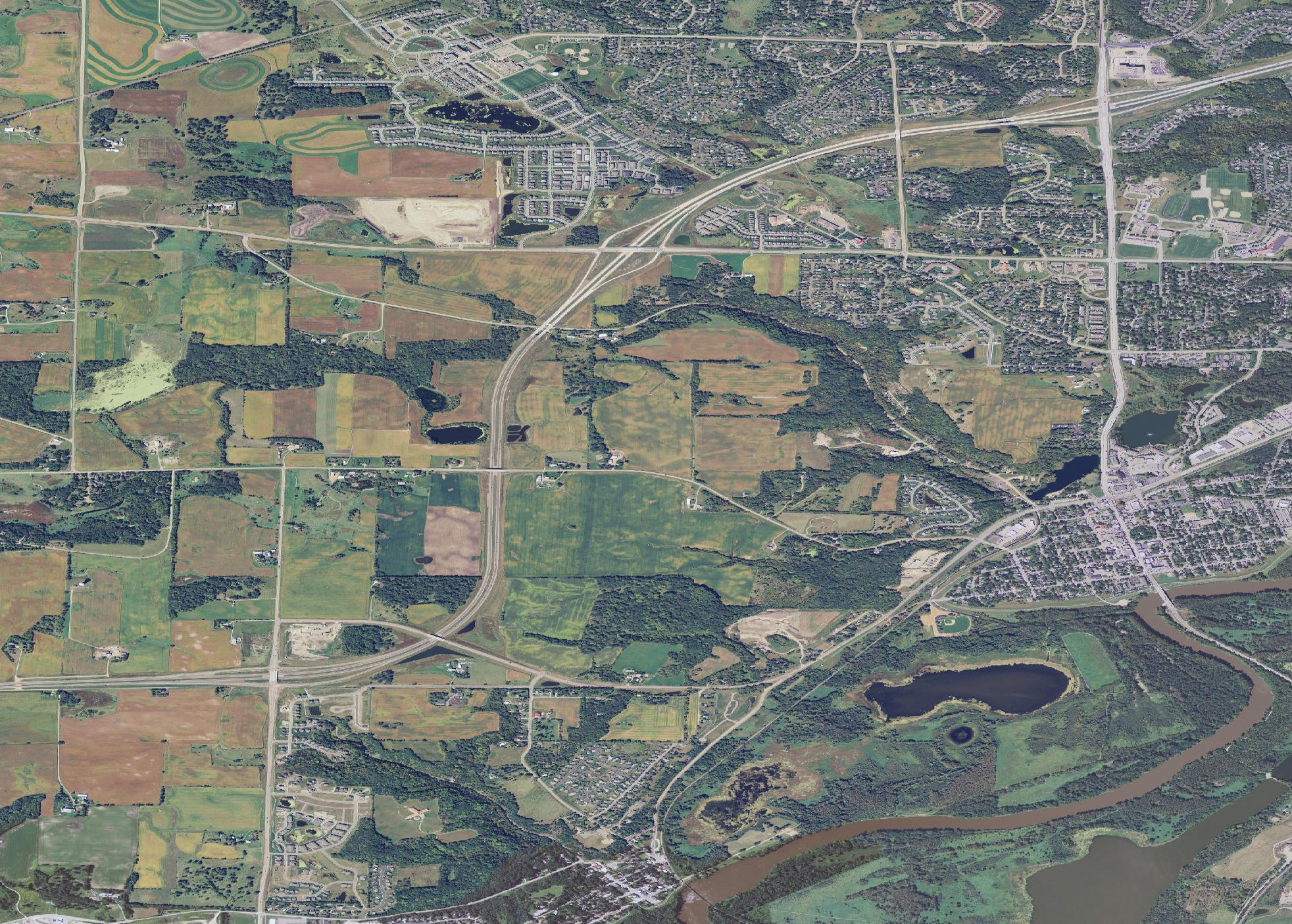
17 Context Analysis Preliminary Findings Growth area is adjacent to major natural, cultural and economic assets, such as downtown Chaska, Minnesota River valley, Hwy 212, Community Center, parks/open spaces Opportunity for future development to have strong connections to these unique assets


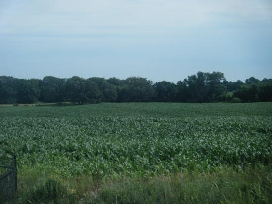


18 Context Analysis Preliminary Findings Growth area is predominantly rolling farm land, highlighted by steep bluffs, woodlands, creek and drainage ravines.

19 Context Analysis Preliminary Findings Radial roadways connect through the area to downtown and the river valley Creek Road CR 140 CR 61 (Chaska Blvd)

20 Context Analysis Preliminary Findings Highway 212 bisects the area east-west with interchanges having a major impact on future roadway network, land use patterns and types of development Proposed 212/140 interchange CR 140 as Minor Arterial and potential reconstruction CR 11/147 rerouted North-south collector streets identified

21 Context Analysis Preliminary Findings West Chaska Creek watershed defines area s landscape with creeks, bluffs, wooded areas, rolling hills and wetlands Major landscape features and roadways define development areas
 Today (after 2006 CPA) Residential conservation or cluster development (1/3 dev) Urban water/sewer services Envisioned as community green")
22 Context Analysis Preliminary Findings Chaska Greenbelt History Began as Freestanding Growth Center concept in early 1990s Continuation of Arboretum OS Originally envisioned as rural residential, protection of Chaska s rural character (4 du/40 acres) Today (after 2006 CPA) Residential conservation or cluster development (1/3 dev) Urban water/sewer services Envisioned as community green spaces, natural resource areas Greenbelt connection missing in SW Chaska

23 Context Analysis Preliminary Findings 2030 Comprehensive Plan SW Chaska Growth Area Heights of Chaska Plan adopted as a guide for development review Comp Plan policy to update & broaden Heights of Chaska Plan to include all of SW Growth Area Policy to protect natural resource systems & open spaces Support for adding Hwy 212/CR 140 interchange West side guided for rural residential and Greenbelt Consider clustered conservation design development along Hwy 212

24 Context Analysis Preliminary Findings Heights of Chaska Concept Plan Highlights Two neighborhoods with small neighborhood retail centers up to 3,600 HHs and 70,000 sq. ft. retail Mix of housing types Community facilities could include elementary school, playfields, daycare centers, churches Extensive open space network composed of green corridors, chain of lakes, Big Woods, and wooded bluffs

25 Context Analysis Preliminary Findings Heights of Chaska Transportation Connections Concept plan based on two Hwy 212 access points/interchanges Southern access point shifted to Carver in final design, leaving a single access point for Heights of Chaska Heights of Chaska AUAR adopted in 2007 need for adding access at CR140 was identified by AUAR

26 Context Analysis Preliminary Findings Chaska Biotech Center City s Objectives 1. Use conservation design 2. Create 8,000-10,000 jobs 3. Provide good physical connections to community 4. Grow indus/comm tax base 5. Take advantage of freeway access to create world class bioscience park 6. Strengthen bioscience industry in SW Metro area 7. Partner with State 8. Partner with research institution 9. Attract major medical complex

27 Context Analysis Preliminary Findings Future trunk sanitary sewer extensions and estimated costs (2008): Southwest District Creek Road route to Biotech Center & beyond - approx. $3M Heights District CR140 route to Hgts of Chaska, potentially west of Hwy $485K South District CR61 route - $590K

28 Public Infrastructure: Parks & Open Space Comp Plan Policies: Consider adding a community park, potentially linked to Big Woods area Plan to add a community playfield Add two neighborhood parks Preserve & protect green corridors as part of community linear park/ravine system

29 Public Infrastructure: Trails Comp Plan Policies: Partner to develop the SW LRT Regional Trail North-south and eastwest community trails Chaska Greenbelt trails and trailhead facilities County bikeway/linking trails

30 Downtown Master Plan Downtown Vision Revitalize Downtown Chaska as the hub of community destinations and gathering places that reflect and celebrate our historic character, traditional small town atmosphere and values. Market Positioning 1. Growth of households and employees in SW Chaska could benefit Downtown businesses 2. Manage competition between SW Area retail and Downtown 3. Revitalize Downtown as a highly desirable destination for SW Area residents and employees

31 Downtown Master Plan Connectivity between Downtown & SW Growth Area CR140 interchange will provide the shortest route from Highway 212 to Downtown, thereby increasing Downtown patronage and enhancing the perceived link between the Heights of Chaska and Downtown Chaska. Key DT Connections 1. CR 140 from Hwy 212 to Hickory St/4 th St 2. CR 61 connections to Hwy 212 and potentially rerouted TH 41 river crossing 3. Potential connection from Hgts. of Chaska (northern) to Creek Rd 4. Trail network connections
32 Previous Related Market Anaylsis Heights of Chaska Concept Plan Attractive site for residential development (2,000 3,000 housing units) Office development problematic due to environmental constraints at Hwy 212 interchanges Potential for limited convenience retail (40,000 50,000 sq. ft.) Carver County 2030 Comprehensive Plan 2030 Retail/Services Space and Land Demand Study 2030 Business Park Space and Land Demand Study Looked at Hwy 212 corridor in SW Chaska
33 Previous Related Market Anaylsis Carver County 2030 Comprehensive Plan 2007 market study Considered trade area households, future population growth and potential competitive developments to estimate 2030 development potential 2030 Retail/Services Space and Land Demand Study Downtown (63% growth estimated) Hwy 41 & Pioneer Trail (125% growth estimated) Hwy 212 in SW Chaska (significant potential retail site) 2030 Business Park Space and Land Demand Study Potential demand of 3 to 3.8 million sq. ft. Potential land needed could be acres
34 Previous Related Market Anaylsis Chaska Downtown Master Plan Expand number of retail businesses in downtown for an underserved market Create a downtown niche for restaurants, also an underserved market Target a mix of independent as well as chain businesses Create a more concentrated and attractive walkable retail area in downtown rather than a spread out retail area, including improved streets, parking and wayfinding Promote retail expansion as part of redevelopment sites Firemen s Park, City Square West
35
Rapid City Downtown Area Master Plan. Draft Plan Concepts April 2016
 Rapid City Downtown Area Master Plan Draft Plan Concepts April 2016 CALL TO ACTION! A Thriving Downtown = Regional Economic Prosperity Rapid City is competing nationally for a limited supply of young skilled
Presentation to Knox County Commission Monday, February 23, 2015
 The Northwest County Sector Plan Update Presentation to Knox County Commission Monday, February 23, 2015 COMMUNITIES OF THE NORTHWEST COUNTY SECTOR Ball Camp Cedar Bluff Last NW Sector Update: 2003 Land
Corridor Goals and Objectives
 Corridor Goals and Objectives This chapter presents the goals and objectives, developed by the Corridor Study Committee, that serve as the purpose and intent of the Corridor Plan. This plan covers a twenty
Comprehensive Plan Update
 Comprehensive Plan Update Today s Agenda 1. Welcome and Presentation 2. Reality Check-Lite Exercise 3. Greenway Mapping Exercise 4. Priority Thought Wall Exercise 5. Next Steps Recap of Feb. Public Meetings
Chapter 13: Implementation Plan
 Chapter 13: 13.1. INTRODUCTION The purpose of the implementation chapter of the Comprehensive Plan is to set forth the actions that the City will take to ensure that the plans, programs and policies set
BASSETT CREEK VALLEY MASTER PLAN OPEN HOUSE
 BASSETT CREEK VALLEY MASTER PLAN OPEN HOUSE February 23, 2006 PROJECT INTRODUCTION Project Area 230 acres $50 million estimated market value (approximately) 50 acres parkland 100 residences (estimated)
Restoration. a brief look at
 Copyright 2009 Canin Associates, Inc. All rights reserved. No part of this publication may be reproduced or transmitted by any means without written permission from Canin Associates, Inc. a brief look
A Break Even Analysis and Potential Profitability of a Proposed Residential Development within the City of La Crosse, Wisconsin USA
 A Break Even Analysis and Potential Profitability of a Proposed Residential Development within the City of La Crosse, Wisconsin USA Chad M. Clower Department of Resource Analysis, Saint Mary s University
TABLE OF CONTENTS. Executive Summary 1-3. Introduction 4-6. Illustrative Site Plan 7. East-West Streets 8. Cooper Street 9-10. Market Street 11-14
 TABLE OF CONTENTS Executive Summary 1-3 Introduction 4-6 Illustrative Site Plan 7 East-West Streets 8 Cooper Street 9-10 Market Street 11-14 Federal Street 15-16 MLK Boulevard 17-20 North-South Streets
KEYPORT COMMUNITY PLAN
 PLANNING COMMISSION TASKS Collect Public Comments on Draft Plan. Provide Clear Direction for: Preferred LAMIRD Boundary Lot Clustering Provision View Protection Recommendation to Board of County Commissioners.
STARTOWN ELEMENTARY SCHOOL
 Chapter 5 Public Services and Community Facilities Schools Public Services and Community Facilities Schools 1 Libraries 3 Public Safety 4 Water Service 5 Sewer Service 5 Electric Service 5 Natural Gas
MEMORANDUM OF AGREEMENT Between THE CITY OF BALTIMORE And THE MID-ATLANTIC FEDERAL PARTNERSHIP FOR THE ENVIRONMENT
 MEMORANDUM OF AGREEMENT Between THE CITY OF BALTIMORE And THE MID-ATLANTIC FEDERAL PARTNERSHIP FOR THE ENVIRONMENT The Mid-Atlantic Federal Partnership for the Environment ( MAFPE ) and the City of Baltimore
ASPEN HILL Minor Master Plan Amendment
 ASPEN HILL Minor Master Plan Amendment Agenda Welcome and Introductions (6:30 PM) Staff Presentation (6:40-7:30 PM) Q&A (7:30-8:00 PM) Community Meeting #2 April 1, 2014 Aspen Hill Library Planning Process
Johnson Ferry Landing
 Atlanta Investment Opportunity The Offering Through its exclusive broker CBRE, the owner of 30 prime acres in East Cobb referred to as Johnson Ferry Landing is seeking quality-oriented, well-capitalized
Application No.: 14.074 Steve Rush, representing Rocky Mountain Power Rocky Mountain Power Project Location: approximately 1600 N. 6800 E.
 Planning Commission Staff Report Planning and Development Services Croydon Substation Conditional Use Permit Public Meeting August 28, 2014 Application No.: 14.074 Applicant: Steve Rush, representing Rocky
Request for Proposals for Preserve of Montrose
 Request for Proposals for Preserve of Montrose RFP Issue Date: March 3, 2015 Proposals Due: April 21, 2015 Issued by the City of Montrose EDA PO BOX 25 MONTROSE MN 55363 763 575 7422 1 1. Intent of Offering
A PPENDICES C OLLIERVILLE 2040 LAND USE PLAN UPDATE
 A PPENDICES C OLLIERVILLE 2040 LAND USE PLAN UPDATE Traditional Neighborhood Character Study with a Neighborhood Center Commercial Node Aldi s is appropriate in a Neighborhood Center School Greenbelt Trail
INTRODUCTION TO ZONING DISTRICT REGULATIONS
 INTRODUCTION TO ZONING DISTRICT REGULATIONS Classification of Zoning Districts Zoning districts in Dorchester County are categorized as Suburban Urban, Suburban Transition, or Rural. These districts are
Chapter 7 ZONING PLAN
 Chapter 7 ZONING PLAN Introduction This Chapter opens with a general description of a zoning plan. It is followed by a brief explanation of the relationship between this Growth Management Plan and the
COUNTY OF ALBEMARLE PLANNING STAFF REPORT SUMMARY. Staff: Claudette Grant
 COUNTY OF ALBEMARLE PLANNING STAFF REPORT SUMMARY Project Name: ZMA 2013-00004 Hollymead Town Center Block VI Planning Commission Public Hearing: July 29, 2014 Staff: Claudette Grant Board of Supervisors
Land Use and Zoning. Land Use Within the Port Madison Indian Reservation
 Land Use and Zoning Land Use Within the Port Madison Indian Reservation A portion of the Suquamish Rural Village is Trust land, owned either by the Tribe or individual tribal members. The following list
Philadelphia County. Land Use and Growth Management Profile
 Philadelphia County is located in the southeastern corner of Pennsylvania and is bordered by the Pennsylvania counties of Delaware, Montgomery, and Bucks, and the New Jersey counties of Burlington, Camden,
College Park North Retail Development The Woodlands, Texas
 SUBJECT PROPERTY FEATURES LOCATION FEATURES ±21,520 SF of prime retail space available Pad site opportunities available for ground lease Adjacent to numerous big box retailers, including Burlington Coat
City of Arnold, Missouri
 City of Arnold, Missouri Business Brochure City of Arnold 2101 Jeffco Blvd. Arnold, MO 63010 Phone: 636-282-2378 Fax: 636-282-6677 E-mail: dbish@arnoldmo.org The City of Arnold is a suburban community
Attachment B Policy Audit Template
 Attachment B Policy Audit Template 5 6 7 8 9 0 Provide A Variety of Transportation Choices Provide A Variety of Transportation Choices Provide A Variety of Transportation Choices Encourage transit-oriented
administrative subdivisions of the counties and are not counted as separate governments in census statistics on governments. IOWA
 IOWA Iowa ranks 17th among the states in number of local governments with 1,954 as of October 2007. COUNTY GOVERNMENTS (99) There are no areas in Iowa lacking county government. The county governing body
Citizen Advisory Group Meeting #1 December 8, 2011 6:00 p.m.
 Citizen Advisory Group Meeting #1 December 8, 2011 6:00 p.m. Meeting Agenda 1. Background Information 2. Policy Framework 3. Plan Development Process 4. Public Input Results 5. Vision Statement 6. Group
Downtown Vancouver Full Block For Sale 1.03 Acre Redevelopment Opportunity
 FOR SALE E Mill Plain & E Main Street, Vancouver, WA E 16th St Main St Columbia St Washington St E 15th St E Mill Plain Blvd Downtown Vancouver Full Block For Sale 1.03 Acre Redevelopment Opportunity $2,00,000
CITY OF ROANOKE AND TOWN OF VINTON, VIRGINIA. RSTP Funds Joint Application FOR
 CITY OF ROANOKE AND TOWN OF VINTON, VIRGINIA RSTP Funds Joint Application FOR Tinker Creek Pedestrian Bridge: Tinker Creek and Glade Creek Greenways Connection Date: September 15, 2014 RSTP Project Profile
IMPLEMENTATION STRATEGIES The following sections list the implementation strategies for following chapters.
 CHAPTER 13: IMPLEMENTATION INTRODUCTION The purpose of the Implementation Chapter is to set forth the actions that the City will take to ensure that the plans, programs, and policies set forth in the plan
CITY COUNCIL / PLANNING COMMISSION JOINT STUDY SESSION AGENDA REPORT
 CITY COUNCIL / PLANNING COMMISSION JOINT STUDY SESSION AGENDA REPORT MEETING DATE: SEPTEMBER 8, 2015 ITEM NUMBER: 1 SUBJECT: PROPOSED GENERAL PLAN LAND USE ALTERNATIVE FOR THE YEAR 2015-2025 GENERAL PLAN
Flood Mitigation Strategy for the Milwaukee 30 th Street Corridor Redevelopment Program
 Flood Mitigation Strategy for the Milwaukee 30 th Street Corridor Redevelopment Program Eric Loucks, P.E., D.WRE Kumar Gali, P.E. June 4, 2015 Outline MMSD Service Area Problem and Challenges Solution
SECTION 2 CORRIDOR A
 SECTION 2 CORRIDOR A 2.1 CORRIDOR A (HILLSBOROUGH RIVER TO 40 TH STREET IN TAMPA) The boundaries for Corridor A can be seen in Figure 2-1. They are as follows: North: I-4 South: Crosstown Expressway (now
THE RUSKIN COMMUNITY PLAN
 THE RUSKIN COMMUNITY PLAN Introduction Ruskin is a historic community situated on the shores of Tampa Bay, the Little Manatee River and the Ruskin Inlet, approximately 16 miles southeast of Tampa. The
Introduction & Welcome
 Proposed SM Wright Freeway Redevelopment Dallas District Halff Associates Baker Consulting Associates April 28, 2009 Introduction & Welcome Alva Baker Baker Consulting Associates Page 1 Project Overview
Rural Residential Buildable Lands Inventory
 The Dalles Periodic Review, May 2013 Rural Residential Lands Inventory Contents Introduction and Summary... 1 Concerns related to the 2007 Analysis... 2 Rural Residential Capacity Summary... 2 Methodology...
2010 Salida Community Priorities Survey Summary Results
 SURVEY BACKGROUND The 2010 Salida Community Priorities Survey was distributed in September in an effort to obtain feedback about the level of support for various priorities identified in the draft Comprehensive
The Metropolitan Planning Commission. DATE: May 19, 2015
 TO: FROM: The Metropolitan Planning Commission MPC Staff DATE: May 19, 2015 SUBJECT: Petition of LLC, Owner Harold Yellin, Agent PIN: 2-0015-01-002 & 003 Lot Size:.85 Acres (approximately) Aldermanic District:
Downtown South Salt Lake Redevelopment City of South Salt Lake
 Project Information LOCAL PLANNING RESOURCE PROGRAM 2015 Downtown South Salt Lake Redevelopment City of South Salt Lake Overview of Objectives: Building a downtown city center could be the most significant
Downtown Tampa Transportation Vision
 Downtown Tampa Transportation Vision Executive Summary August 1, 2006 Hillsborough County Metropolitan Planning Organization County Center, 18 th Floor Tampa, Florida 33602 813-272-5940 www.hillsboroughmpo.org
What do we already know about Bradford-on-Avon community area?
 What do we already know about Bradford-on-Avon community area? Bradford-on-Avon is one of the smaller market towns in Wiltshire. It has good public transport connectivity and functions as a popular tourist
REQUEST FOR PROPOSAL. Consulting Services for a Thomas Street Corridor Master Plan
 REQUEST FOR PROPOSAL Consulting Services for a Thomas Street Corridor Master Plan INTRODUCTION The city of Wausau is seeking a qualified planning, development, design, and engineering consultant to develop
City of Tampa Zoning Districts
 City of Tampa Zoning Districts The city is divided by chapter 2 into zoning districts, the boundaries and designations of which are shown in a series of maps, covering in combination the entire land and
Guiding Principles. McCauley Area Focused Urban Design Plan. 1 Connect: Chinatown and Little Italy with downtown and surrounding areas
 McCauley Area Guiding Principles 1 Connect: Chinatown and Little Italy with downtown and surrounding areas 2 Strengthen: Cultural character in Chinatown and Little Italy 3 Develop: Strong East West pedestrian
Smart Growth Illustrated: Developer s Guidebook. City of Bentonville Community Development Department October 2006
 Smart Growth Illustrated: Developer s Guidebook City of Bentonville Community Development Department October 2006 1 Table of Contents What is Smart Growth...3 Six Goals of Smart Growth 5 Ten Tools of Smart
TABLE OF CONTENTS. INTRODUCTION...1 Purpose of a Comprehensive Plan...1 McKenzie County Comprehensive Plan...1 Definitions...2 Goal...2 Vision...
 MCKENZIE COUNTY COMPREHENSIVE PLAN TABLE OF CONTENTS INTRODUCTION...1 Purpose of a Comprehensive Plan...1 McKenzie County Comprehensive Plan...1 Definitions...2 Goal....2 Vision...3 ECONOMIC DEVELOPMENT...4
Motorcycle & Pedestrian Master Plans in Indianapolis, Indiana
 PROJECT PURPOSE The Warsaw + Winona Lake Bicycle and Pedestrian Master Plan establishes a comprehensive framework for a connected bicycle and pedestrian system that will be used for both recreation and
Market Analysis Retail Housing Office [CITY OF BERLIN MARKET ANALYSIS] City of Berlin, Wisconsin
![Market Analysis Retail Housing Office [CITY OF BERLIN MARKET ANALYSIS] City of Berlin, Wisconsin](/thumbs/34/17190064.jpg "Market Analysis Retail Housing Office [CITY OF BERLIN MARKET ANALYSIS] City of Berlin, Wisconsin") 2013 Market Analysis Retail Housing Office [CITY OF BERLIN MARKET ANALYSIS] City of Berlin, Wisconsin Executive Summary Berlin is a community of roughly 5,500 residents, located along the Fox River in
2013 Market Analysis Retail Housing Office [CITY OF BERLIN MARKET ANALYSIS] City of Berlin, Wisconsin Executive Summary Berlin is a community of roughly 5,500 residents, located along the Fox River in
Tampa Brownfields Program. Prepared for: FBA Improving Access to Health and Health Care Workshop
 Tampa Brownfields Program Prepared for: FBA Improving Access to Health and Health Care Workshop October 29, 2012 Tampa EPA Brownfields History EPA Brownfields Funding 1992: $200,000 EPA Brownfields Pilot
Greenway Area Study Recommended Master Plan Executive Summary November, 2007 Introduction
 Greenway Area Study Recommended Master Plan Executive Summary November, 2007 Introduction The Marion County has been tasked by the Board of County Commissioners to conduct a series of corridor, or area
Strategic Planning. Frequently Asked Questions. Member Services
 The SID is proactively working to combat these challenges and is poised to take the necessary steps to ensure downtown transitions from these difficult times to a vibrant and active center Strategic Planning
Lincoln Downtown Master Plan Update
 Lincoln Downtown Master Plan Update Table of Contents Executive Summary........................................... 1 Complete Streets Framework.................................... 3 Promenade Creating
TOWN OF CARY CONDITIONAL USE ZONING PERMIT. 412 Rutherglen Cary, NC 27511-6437. 412 Rutherglen Cary, NC 27511-6437
 TOWN OF CARY CONDITIONAL USE ZONING PERMIT PETITION: PETITIONER(S): OWNER(S): LOCATION: 01-REZ-16 204 N. Dixon Avenue, Cary, NC PARCEL IDENTIFICATION: 076418218784 REALID: 0031004 AREA: APPROVED ZONING:
Frederick. Frederick. Maryland. Smart Growth Successes. Frederick. Maryland Department of Planning
 Frederick Frederick Maryland Smart Growth Successes Frederick Maryland Department of Planning Smart, Green & Growing Martin O Malley Governor Anthony G. Brown Lt. Governor Maryland Department of Planning
WESTFIELD-WASHINGTON ADVISORY PLAN COMMISSION December 7, 2015 1512-SPP-24 & 1512-ODP-24
 Petition Number: Subject Site Address: Petitioner: Request: East side of Oak Road, north of 151 st Street Langston Development Co. Primary Plat and Overall Development Plan amendment review for Mapleridge
Town of Snowmass Village. PO Box 5010. Or Delivered To: 1 P a g e
 The Town of Snowmass Village invites qualified consultants to submit a proposal to develop a Request Community for Connectivity Proposals Plan for the Town. Proposals must be submitted by 4:00 pm Friday
ELEMENT 4 - FUTURE LAND USE ELEMENT
 ELEMENT 4 - FUTURE LAND USE ELEMENT Goal 1 To create a long-range development pattern which directs growth into developable areas and away from environmentally sensitive areas, in a manner that is compatible
OVERVIEW PROJECT SUMMARY
 OVERVIEW Cesar Chavez showcases how to successfully redesign a primary arterial route into a neighborhood destination, improving modal share, water sensitive design, biodiversity and safety whilst maintaining
Request for Information
 Request for Information Date of Issue: February 13, 2015 Responses Due: May 29, 2015 Overview Forest West Properties Inc. (FWP) is soliciting qualifications from qualified developers for the development
The Lancaster Medical District Master Plan. The Lancaster Campus District 1
 The Lancaster Medical District Master Plan The Lancaster Campus District 1 Table of Contents 1 INTRODUCTION 3 2 THE PLANNING PROCESS 4 Assumptions 6 3 PLANNING CONTEXT AND ECONOMIC OUTLOOK 7 Site Analysis
Southwest Light Rail Transit Minneapolis-St. Paul, Minnesota New Starts Project Development (Rating Assigned November 2014)
") Southwest Light Rail Transit Minneapolis-St. Paul, Minnesota New Starts Project Development (Rating Assigned November 2014) Summary Description Proposed Project: Light Rail Transit 15.7 Miles, 17 Stations
Southwest Light Rail Transit Minneapolis-St. Paul, Minnesota New Starts Project Development (Rating Assigned November 2014) Summary Description Proposed Project: Light Rail Transit 15.7 Miles, 17 Stations
Marshall V. Davidson Jr. Richard N. Gill
 Marshall V. Davidson Jr. Richard N. Gill 512-225-2481 210-581-7720 TOTAL ACREAGE: 762.203 KMDS SITES: D E F INFRASTRUCTURE I J K L O U P Q R lum Creek offers over 700 acres of commercial real estate for
CITY MANAGER $175,000 - $195,000. Plus Excellent Benefits. Apply by March 20, 2016 (open until filled)
") CITY MANAGER $175,000 - $195,000 Plus Excellent Benefits Apply by March 20, 2016 (open until filled) WHY APPLY? Located in south Lake Washington, just 10 minutes east of Seattle and 10 minutes west of
CITY MANAGER $175,000 - $195,000 Plus Excellent Benefits Apply by March 20, 2016 (open until filled) WHY APPLY? Located in south Lake Washington, just 10 minutes east of Seattle and 10 minutes west of
Near West Side Comprehensive Plan Executive Summary (Revised) April 2004 City of Milwaukee DCD
 April 2004 City of Milwaukee DCD") Near West Side Comprehensive Plan Executive Summary (Revised) April 2004 City of Milwaukee DCD Boundaries The Near West Side Comprehensive Plan covers a broad area immediately west of Milwaukee s downtown.
Near West Side Comprehensive Plan Executive Summary (Revised) April 2004 City of Milwaukee DCD Boundaries The Near West Side Comprehensive Plan covers a broad area immediately west of Milwaukee s downtown.
VANDERBILT COMPARISON
 Village of Vanderbilt Comparison One County, One Vision Master Plan (2000) 1 15 Improve recreation in Otsego County by assessing the availability and need to improve bike paths, county recreation facilities,
Eagle Commuter Rail Denver, Colorado Final Design (Based upon information received by FTA in November 2010)
") Eagle Commuter Rail Denver, Colorado Final Design (Based upon information received by FTA in November 2010) Summary Description Proposed Project: Electrified Commuter Rail 30.2 Miles, 13 Stations Total
Eagle Commuter Rail Denver, Colorado Final Design (Based upon information received by FTA in November 2010) Summary Description Proposed Project: Electrified Commuter Rail 30.2 Miles, 13 Stations Total
Why Downtowns Matter ~ ~ Geoffrey Anderson
 Why Downtowns Matter ~ ~ Geoffrey Anderson We re a little confused Richard Drudl Why Downtowns? Increasing demand for walkable live/work/play destinations Downtowns are again a key factor in economic
Revere Beach Transit-Oriented Development Parcels Revere, Massachusetts. Design and Development Guidelines. Part Two.
 Revere Beach Transit-Oriented Development Parcels Revere, Massachusetts Design and Development Guidelines Request for Qualifications and Expressions of Interest with Preliminary Development Plans Part
Texas Motor Speedway Area Master Plan January 2009 WATER INFRASTRUCTURE
 WATER AND SEWER INFRASTRUCTURE Water and Sewer Infrastructure in the TMS Study Area Streets and other transportation infrastructure are addressed in Chapter 6 of this plan. Non-transportation infrastructure
DOUGLAS COUNTY RESOLUTION NO. 87-38 CITY OF LAWRENCE RESOLUTION NO. 5094
 DOUGLAS COUNTY RESOLUTION NO. 87-38 CITY OF LAWRENCE RESOLUTION NO. 5094 A JOINT RESOLUTION OF THE GOVERNING BODIES OF DOUGLAS COUNTY AND THE CITY OF LAWRENCE CONCERNING THE SOUTH LAWRENCE TRAFFICWAY;
RDA Development Opportunities
 RDA Development Opportunities West Capitol Hill Development Opportunity Marmalade Block Development RDA hired Citiventure Associates to create a development strategy and implementation plan RDA property
12 February 8, 2012 Public Hearing APPLICANT:
 12 February 8, 2012 Public Hearing APPLICANT: PROPERTY OWNER: VIRGINIA BEACH ASSOCIATES, LC REQUEST: Conditional Change of Zoning (I-1 to Conditional A-36) STAFF PLANNER: Faith Christie ADDRESS / DESCRIPTION:
Scenario Planning Report. Austin South Shore Central
 View of Downtown Austin from South Shore s Statesman site. Introduction Austin s South Shore Central Sub-District South Shore Central is an 88-acre sub-district of the waterfront overlay. As a fairly auto-oriented
Chapter 7: Sanitary Sewer Plan. Introduction. Metropolitan Council Coordination
 Chapter 7: Sanitary Sewer Plan Introduction The 2030 Sanitary Sewer Plan was prepared for two primary reasons. The first purpose is to provide recommendations and guidance to the City of Lino Lakes by
VISION, DESIGN PRINCIPLES & OVERALL PLANNING STRATEGY
 3 VISION, DESIGN PRINCIPLES & OVERALL PLANNING STRATEGY The overall planning strategy for the Bank Street CDP is to ensure that future development is undertaken in a coordinated and planned approach, supported
HIGHWAY DEPARTMENT ACCESS AND RIGHT OF WAY WIDTH GUIDELINES
 Approved 6/26/01 HIGHWAY DEPARTMENT ACCESS AND RIGHT OF WAY WIDTH GUIDELINES All new, modified and/or changed use access(es) onto county roads shall be subject to the access and corridor protection guidelines
Guide to Boulder Neighborhoods
 Guide to Boulder Neighborhoods Presented by Kearney Realty Co. City of Boulder: Overview Population - 102,800 Area - 25 square miles Founded - 1858 Altitude - 5,430 feet Major Industries - University of
What we build today will create Denver s tomorrow. Signature development projects will strengthen our economy, create jobs and improve neighborhoods.
 Mayor Hancock s Vision for Building a World-Class City What we build today will create Denver s tomorrow. Signature development projects will strengthen our economy, create jobs and improve neighborhoods.
Implementing the Transportation Alternatives Program for the National Capital Region
 Implementing the Transportation Alternatives Program for the National Capital Region Safe Routes to School Regional Meeting October 29, 2013 Sarah Crawford National Capital Region Transportation Planning
LEAGUE NOTES ON APPROVED COMMUNITY WATER SUPPLY PLAN
 1 AUGUST 2011 LEAGUE NOTES ON APPROVED COMMUNITY WATER SUPPLY PLAN KEY ELEMENTS OF THE PLAN: 1. Replace the existing unsafe Ragged Mountain dam with a new dam and raise the reservoir pool level initially
St. Clair College Planning Area Introduction
 Introduction What is the Study Area? St. Clair College Planning Area is bounded by Highway 3 to the west, Cabana Road to the north, the residential community of South Windsor to the east and Cousineau
REZONING 16-000009 & PRELIMINARY PLAT 16-000005
 REZONING 16-000009 & PRELIMINARY PLAT 16-000005 REZONING REQUEST AND REVISED PRELIMINARY PLAT FOR THE BLUFFS AT WINDCASTLE - 4165 FAREDALE LANE Application: Engineer: Developer: Property Owner: Current
The City of Duluth 2014 Comprehensive Plan. DRAFT Assessment
 The City of Duluth 2014 Comprehensive Plan DRAFT Assessment This document was prepared by the Atlanta Regional Commission using funds provided by the State of Georgia CONTENTS Executive Summary 5 Yesterday
Comprehensive Plan Policies that support Infill and Mixed Use
 Comprehensive Plan Policies that support Infill and Mixed Use Introduction A comprehensive plan provides a broad vision for the future growth of a community. It is often formulated using community visioning
Sincerely, The Envision TWO40 Steering Committee
 SHOP EAT WORK LIVE The Heart of South Oklahoma City Across the metro, people know the I-240 corridor as the heart of South Oklahoma City. Unfortunately, what they perceive about this stretch of highway
Los Angeles Union Station, CA Sustainable Neighborhood Assessment. April 22-23, 2014
 Los Angeles Union Station, CA Sustainable Neighborhood Assessment April 22-23, 2014 Sustainable Neighborhood Assessment Through the Sustainable Neighborhood Assessment Tool developed by Global future development
Executive Director s Recommendation Commission Meeting: July 11, 2013
 Executive Director s Recommendation Commission Meeting: July 11, 2013 PROJECT Russell Road Widening Phase 2 United States Marine Corps Base Quantico Prince William County, Virginia SUBMITTED BY United
South Greeley Highway Corridor: Main Street of South Cheyenne
 South Greeley Highway Corridor: Main Street of South Cheyenne South Cheyenne Community Development Association Adopted by the Laramie County Board of Commissioners, June 18, 2013 The South Cheyenne Community
Schenk-Atwood Neighborhood Business District Master Plan
 Schenk-Atwood Neighborhood Business District Master Plan Prepared for the Schenk-Atwood Revitalization Association (SARA) and the City of Madison SCHREIBER/ANDERSON ASSOCIATES, INC. BEST Real Estate Group,
Lents Town Center Mixed-Use Market Study Office Market Analysis Lents, Oregon
 Lents Town Center Mixed-Use Market Study Office Market Analysis Lents, Oregon Portland Development Commission January 2008 Draft Copy 9220 SW Barbur Boulevard Portland, Oregon 97219 503.636.1659 www.marketekinc.com
Draft Goals and Objectives Wadena Comprehensive Plan City of Wadena, Minnesota. Land Use Goals:
 Draft Goals and Objectives Wadena Comprehensive Plan City of Wadena, Minnesota Land Use Goals: 1. Growth in Wadena will be undertaken in such a manner as to create a full range of living, working, shopping,
STAFF REPORT. December 20, 2004. North District Community Council. Director of Community Planning - North
 STAFF REPORT December 20, 2004 To: From: Subject: North District Community Council Director of Community Planning - North Preliminary Report Respecting Revised Application OPA & Rezoning Application 01
South Phase Land Offering of 54 Lots
 South Phase Land Offering of 54 Lots Residential Lots in the Seola Gardens Master Planned Community for information please contact: James Rooney KCHA Project Manager JamesR@KCHA.org Phone: 206.826.5303
Planning for the future. building a great city, great neighbourhoods
 Planning for the future building a great city, great neighbourhoods Table of contents 1 Looking ahead 2.4 million Calgarians 2 Goals 3 Building a sustainable, connected city of great neighbourhoods 4 Finding
Economic Development Element
 The Strawberry Ladies by Tara Stood Economic Development Element Economic development enhances San Clemente s quality of life by providing local goods and services and expanding employment and business
4. Priority Areas of Conservation
 4. Priority Areas of Conservation A. SIGNIFICANT RESOURCE AREAS This Open Space and Farmland Plan identifies the key issues facing open space and agricultural resources in the Town, highlights the location
Implementing Plans Through Public / Private Partnerships
 Implementing Plans Through Public / Private Partnerships WAPA / WASLA 2006 Spring Conference Mark A. Olinger Department of Planning & Development City of Madison April 7, 2006 Outline Planning s s Role
Phases 2 & 3, & Addendum Urban Structure Plan Options for West Whitby
 7. 5 A d v a n t a g e s a n d D i s a d v a n t a g e s Table 22 summarizes the advantages and disadvantages of each option based on the evaluation of Table 16. Dillon Consulting Limited Page 75 Table
Iowa Smart Planning. Legislative Guide March 2011
 Iowa Smart Planning Legislative Guide March 2011 Rebuild Iowa Office Wallace State Office Building 529 East 9 th St Des Moines, IA 50319 515-242-5004 www.rio.iowa.gov Iowa Smart Planning Legislation The
Addendum to the Arterial Transitway Corridors Study
 January 2013 1 Addendum to the Arterial Transitway Corridors Study The Arterial Transitway Corridors Study (ATCS) evaluated and prioritized arterial bus rapid transit (BRT) improvements to nine corridors