COMPANY PROFILE PT. CITRA GEOSPASIAL INDONESIA
|
|
|
- Alice George
- 7 years ago
- Views:
Transcription

1 COMPANY PROFILE PT. CITRA GEOSPASIAL INDONESIA UAV/Drone Specialist, Aerial Video and Imaging, LiDAR, Topography & Bathymetry Survey, WebGIS Application

2 ABOUT US Citra Geospasial Indonesia is a company which provides novel state-of-the-art geospatial technology to meet the needs and specifications of the customer. We produce digital imagery from aerial photography, digital UAV scanners, and satellites. We have a full-service image processing division, geo-referencing and perform rectifications, translations, compression. When solutions do not exist we create them, like the advanced systems we have implemented for the accurate collection, analysis, presentation and integration of geospatial information. Our top priority at Citra Geospasial Indonesia has always been to provide exemplary service and quality, by focusing on exceeding the expectations of our clients and ensuring their complete satisfaction. We welcome enquiries from all industries and markets. Our services enable you to capture, analyze, and monitor everything from vast expanses of landscape down to individual pieces. UAV/Drone Specialist, Aerial Video and Imaging, LiDAR, Topography &


3 FIND & CONTACT US UAV/Drone Specialist, Aerial Video and Imaging, LiDAR, Topography &


4 OUR SERVICES We provide broad services based on geospatial data and technology UAV/Drone Survey, Aerial Video and Imaging, LiDAR Survey, Topography & Bathymetry Survey, WebGIS Development Satellite Topography Data Acquisition and Processing UAV/Drone Specialist, Aerial Video and Imaging, LiDAR, Topography &

5 EXPERIENCES 1. PT. Batutua Tembaga Raya 2. PT. Bharinto Melak Ekatama 3. PT. Britmindo 4. PT. Incasi Raya Group 5. PT. Indra Karya 6. PT. Integrasia Utama 7. PT. Citra Segara 8. PT. Jasa Marga 9. PT. Keusik Batu Galunggung 10. PT. Timbang Deli Indonesia 11. PT. Pertamina Hulu 12. PT. Taiyo Sinar Raya Teknik 13. PT. Nusa Halmahera Minerals 14. PT. Sucofindo 15. PT. Surtech 16. PT. Wilmar Groups 17. PT. Tempirai Energy Resources 18. PT. Astra Graphia IT 19. PT. Astra Agro Lestari 20. PT. GeoXP 22. etc. UAV/Drone Specialist, Aerial Video and Imaging, LiDAR, Topography &

6 SURVEY & MAPPING AREAS Coal Mining Copper Mining Oil & Gas Tourism Dense Urbanized Area Oil Palm Plantation Agriculture Coastal Zone Port Design Hydrography Survey Coastal Modeling & Met- Ocean Survey Soil Investigation Geophysical UAV/Drone Specialist, Aerial Video and Imaging, LiDAR, Topography &

")


7 OUR PRODUCTS Our products are: GEO 1.1 RPUAS (Remotely Piloted Unmanned Aircraft System) with fixed-wing and multi-rotor types Oil Palm Tree Calculator Software GEO 1.2 Octocopter for surveillance & monitoring
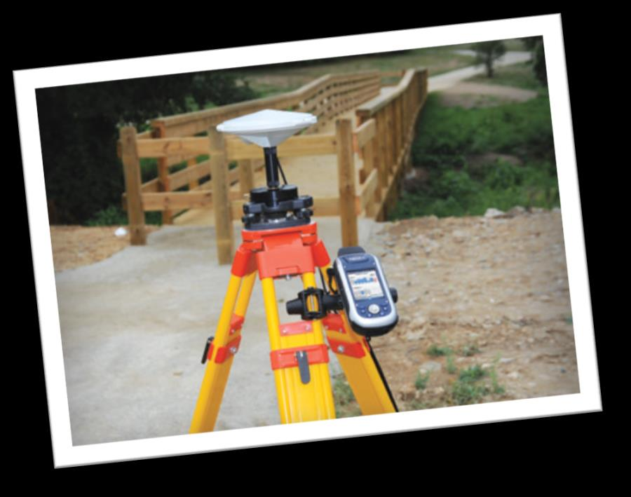


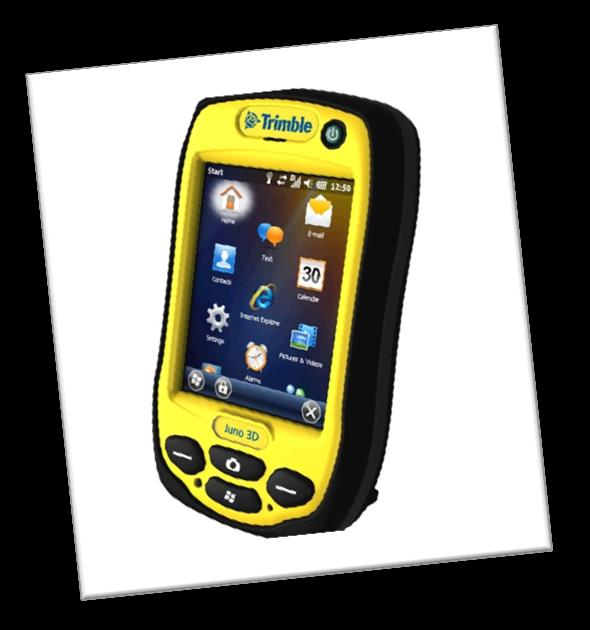


8 SUPPORTING TECHNOLOGY (Hardware)


9 SUPPORTING TECHNOLOGY (Software)
 B.")
10 OUR EXPERTS/BRAIN POWER (more than 10 years experience) Ph.D. in Remote Sensing and GIS Ph.D. in Environmental Engineering Ph.D in Human-Environment Conflict Assessment Ph.D in Economic Studies B.Sc in Geography (GIS Application and GIS Database) B.Eng in Electrical, Geodetic, Geologist, Mechanical, Mine and Marine Engineering UAV/Drone Specialist, Aerial Video and Imaging, LiDAR, Topography &
* WebGIS* *additional post-processing time and fee apply UAV/Drone Specialist, Aerial Video and Imaging, LiDAR,")
11 OUPUT PRODUCTS Orthomosaic image Aerial Photo RGB/IR/Multispect/NDVI/Thermal Aerial Video RGB/IR/Multispect/NDVI/Thermal DSM-DTM and contour Land use map (vector map)* WebGIS* *additional post-processing time and fee apply UAV/Drone Specialist, Aerial Video and Imaging, LiDAR, Topography &
12 Aerial Photo Samples UAV/Drone Specialist, Aerial Video and Imaging, LiDAR, Topography &

13 Coal Mine Site at Banjarmasin, South Kalimantan, 1cm resolution

14 Tourism Site, Tabanan, Bali, 7cm resolution

15 Dense Urban Area, Malang City, East Java, 1cm resolution

16 Oil Palm Plantation, Siak, Riau 30cm resolution


17 Oil & Gas, East kalimantan 5cm resolution
 UAV/Drone Specialist, Aerial Video and Imaging, LiDAR, Topography")
18 OUPUT PRODUCTS Sample data of UAV with LiDAR sensor (300,000 points per second) UAV/Drone Specialist, Aerial Video and Imaging, LiDAR, Topography &
 UAV/Drone Specialist, Aerial Video and Imaging, LiDAR, Topography")
19 OUPUT PRODUCTS Sample of DEM derived from satellite topography data (spatial resolution 15 cm with vertical accuracy 30 cm) UAV/Drone Specialist, Aerial Video and Imaging, LiDAR, Topography &

20 UAV/Drone Specialist, Aerial Video and Imaging, LiDAR, Topography &
WHAT IS GIS - AN INRODUCTION
 WHAT IS GIS - AN INRODUCTION GIS DEFINITION GIS is an acronym for: Geographic Information Systems Geographic This term is used because GIS tend to deal primarily with geographic or spatial features. Information
Ocean Engineering, Surveying and Mapping Services
 Ocean Engineering, Surveying and Mapping Services FUGRO PELAGOS, INC. Fugro collects and interprets data related to the earth s surface and the soils and rocks beneath. It provides advice based on the
The Status of Geospatial Information Management in China
 The Status of Geospatial Information Management in China Submitted by the National Administration of Surveying, Mapping and Geoinformation of China 1. Administration System The National Administration
IFSEC 2014. CUAASA and UAS Overview
 IFSEC 2014 CUAASA and UAS Overview Introduction An Unmanned Aerial Vehicle (UAV), Unmanned Aircraft System (UAS) or as named by ICAO as a Remotely Piloted Aircraft (RPA) and commonly known as drone, is
APPLICATION OF GOOGLE EARTH FOR THE DEVELOPMENT OF BASE MAP IN THE CASE OF GISH ABBAY SEKELA, AMHARA STATE, ETHIOPIA
 APPLICATION OF GOOGLE EARTH FOR THE DEVELOPMENT OF BASE MAP IN THE CASE OF GISH ABBAY SEKELA, AMHARA STATE, ETHIOPIA Abineh Tilahun Department of Geography and environmental studies, Adigrat University,
Key words: Laser Scanning, LIDAR, Surveying and Mapping, Point Cloud, Geospatial software
 Volume 5, Issue 5, May 2015 ISSN: 2277 128X International Journal of Advanced Research in Computer Science and Software Engineering Research Paper Available online at: www.ijarcsse.com Comparative Study
Image Analysis CHAPTER 16 16.1 ANALYSIS PROCEDURES
 CHAPTER 16 Image Analysis 16.1 ANALYSIS PROCEDURES Studies for various disciplines require different technical approaches, but there is a generalized pattern for geology, soils, range, wetlands, archeology,
A GIS helps you answer questions and solve problems by looking at your data in a way that is quickly understood and easily shared.
 A Geographic Information System (GIS) integrates hardware, software, and data for capturing, managing, analyzing, and displaying all forms of geographically referenced information. GIS allows us to view,
Geological Consultants Exploration Services Mineral Investment
 Geological Consultants Exploration Services Mineral Investment Geology and Mining Technology About PT GMT Indonesia Company Background PT GMT Indonesia (GMT) is a PMA company formed in 2001 with the intention
'Developments and benefits of hydrographic surveying using multispectral imagery in the coastal zone
 Abstract With the recent launch of enhanced high-resolution commercial satellites, available imagery has improved from four-bands to eight-band multispectral. Simultaneously developments in remote sensing
Curtailing Deforestation in Indonesia: Improving Forest Mapping and Monitoring using Drones Technology
 Curtailing Deforestation in Indonesia: Improving Forest Mapping and Monitoring using Drones Technology Indonesia is home to one of the world s largest tropical forest, mangrove, peat land, and biodiversity;
BSc (Hons) in Geomatics (Surveying & Mapping) DT112
 in Geomatics (Surveying & Mapping) DT112") School of Spatial Planning DEPARTMENT OF SPATIAL INFORMATION SCIENCES BSc (Hons) in Geomatics (Surveying & Mapping) December 2011 HAVE YOU EVER WONDERED? How Sat-Nav systems work? geekanoids.co.uk Imagery
School of Spatial Planning DEPARTMENT OF SPATIAL INFORMATION SCIENCES BSc (Hons) in Geomatics (Surveying & Mapping) December 2011 HAVE YOU EVER WONDERED? How Sat-Nav systems work? geekanoids.co.uk Imagery
BSc (Hons) in Geomatics (Surveying & Mapping) DT112
 in Geomatics (Surveying & Mapping) DT112") School of Spatial Planning DEPARTMENT OF SPATIAL INFORMATION SCIENCES BSc (Hons) in Geomatics (Surveying & Mapping) How Sat-Nav systems work? December 2011 geekanoids.co.uk Imagery by baboom.ie How the
School of Spatial Planning DEPARTMENT OF SPATIAL INFORMATION SCIENCES BSc (Hons) in Geomatics (Surveying & Mapping) How Sat-Nav systems work? December 2011 geekanoids.co.uk Imagery by baboom.ie How the
Design Specifications of an UAV for Environmental Monitoring, Safety, Video Surveillance, and Urban Security
 Design Specifications of an UAV for Environmental Monitoring, Safety, Video Surveillance, and Urban Security A. Alessandri, P. Bagnerini, M. Gaggero, M. Ghio, R. Martinelli University of Genoa - Faculty
IMPERVIOUS SURFACE MAPPING UTILIZING HIGH RESOLUTION IMAGERIES. Authors: B. Acharya, K. Pomper, B. Gyawali, K. Bhattarai, T.
 IMPERVIOUS SURFACE MAPPING UTILIZING HIGH RESOLUTION IMAGERIES Authors: B. Acharya, K. Pomper, B. Gyawali, K. Bhattarai, T. Tsegaye ABSTRACT Accurate mapping of artificial or natural impervious surfaces
Technology Trends In Geoinformation
 Technology Trends In Geoinformation Dato Prof. Sr Dr. Abdul Kadir Bin Taib Department of Survey and Mapping Malaysia (JUPEM) Email: drkadir@jupem.gov.my www.jupem.gov.my NGIS 2008 3 rd. National GIS Conference
MAPPING MINNEAPOLIS URBAN TREE CANOPY. Why is Tree Canopy Important? Project Background. Mapping Minneapolis Urban Tree Canopy.
 MAPPING MINNEAPOLIS URBAN TREE CANOPY Why is Tree Canopy Important? Trees are an important component of urban environments. In addition to their aesthetic value, trees have significant economic and environmental
Development of Automatic shooting and telemetry system for UAV photogrammetry INTRODUCTION
 Development of Automatic shooting and telemetry system for UAV photogrammetry Jinwoo PARK 1, Minseok KIM 1, Khin Mar Yee 1, Chuluong CHOI 1 1 Department of Spatial Information Engineering, Pukyong National
The optimum offshore survey workflow for high-quality GIS results. by integrating CARIS & EIVA software
 The optimum offshore survey workflow for high-quality GIS results by integrating CARIS & EIVA software As a result of a unique and dedicated partnership, CARIS and EIVA offer the optimum solution for offshore
How To Make An Orthophoto
 ISSUE 2 SEPTEMBER 2014 TSA Endorsed by: CLIENT GUIDE TO DIGITAL ORTHO- PHOTOGRAPHY The Survey Association s Client Guides are primarily aimed at other professionals such as engineers, architects, planners
Coastal Engineering Indices to Inform Regional Management
 Coastal Engineering Indices to Inform Regional Management Lauren Dunkin FSBPA 14 February 2013 Outline Program overview Standard products Coastal Engineering Index Conclusion and future work US Army Corps
One Survey One Hundred Solutions. TLidar in Africa
 TLidar in Africa Africa Geospatial Forum The Survey Profession 35 Years of Change Johannesburg 19 August 2015 Norman Banks Change & Progress! The reasonable man adapts himself to the world; the unreasonable
CIESIN Columbia University
 Conference on Climate Change and Official Statistics Oslo, Norway, 14-16 April 2008 The Role of Spatial Data Infrastructure in Integrating Climate Change Information with a Focus on Monitoring Observed
Sextant. Spatial Data Infrastructure for Marine Environment. C. Satra Le Bris, E. Quimbert, M. Treguer
 Sextant On-Line information system for marine geographical information E. Quimbert, M. Bellouis, F. Lecuy, M. Treguer Centre de Bretagne BP 70, Plouzané 29280 France E-mail: sextant@ifremer.fr Sextant
KNB MASTER SCHOOLARSHIP PROGRAM
 KNB MASTER SCHOOLARSHIP PROGRAM AGRICULTURAL TECHNOLOGY AGRICULTURE ANIMAL SCIENCE ECONOMIC AND MANAGEMENT FISHERIES AND MARINE SCIENCE FORESTRY Bogor Agricultural University (IPB) Agicultural engineering
STATE OF NEVADA Department of Administration Division of Human Resource Management CLASS SPECIFICATION
 STATE OF NEVADA Department of Administration Division of Human Resource Management CLASS SPECIFICATION TITLE PHOTOGRAMMETRIST/CARTOGRAPHER V 39 6.102 PHOTOGRAMMETRIST/CARTOGRAPHER II 33 6.110 PHOTOGRAMMETRIST/CARTOGRAPHER
Introduction to GIS (Basics, Data, Analysis) & Case Studies. 13 th May 2004. Content. What is GIS?
 & Case Studies. 13 th May 2004. Content. What is GIS?") Introduction to GIS (Basics, Data, Analysis) & Case Studies 13 th May 2004 Content Introduction to GIS Data concepts Data input Analysis Applications selected examples What is GIS? Geographic Information
Introduction to GIS (Basics, Data, Analysis) & Case Studies 13 th May 2004 Content Introduction to GIS Data concepts Data input Analysis Applications selected examples What is GIS? Geographic Information
Technologies Enabling the Evolution of a Smart City. Brad Schmidt, Intergraph Canada
 Technologies Enabling the Evolution of a Smart City Brad Schmidt, Intergraph Canada AGENDA The Smart City Key Challenges Facing Cities Technology Challenges Smart Sensor Integration Smart Apps Smart Data
12345 El Monte Road Los Altos Hills, California 94022 650.949.7777
 12345 El Monte Road Los Altos Hills, California 94022 650.949.7777 Geospatial Technology Occupations Report for Greater Bay Area Region (Alameda, Contra Costa, Marin, Napa, San Francisco, San Mateo, Santa
Opportunities for the generation of high resolution digital elevation models based on small format aerial photography
 Opportunities for the generation of high resolution digital elevation models based on small format aerial photography Boudewijn van Leeuwen 1, József Szatmári 1, Zalán Tobak 1, Csaba Németh 1, Gábor Hauberger
The Use of Geographic Information Systems in Risk Assessment
 The Use of Geographic Information Systems in Risk Assessment With Specific Focus on the RiVAMP Methodology Presented by Nadine Brown August 27, 2012 Climate Studies Group Mona Climate Change Workshop Presentation
3D Point Cloud Analytics for Updating 3D City Models
 3D Point Cloud Analytics for Updating 3D City Models Rico Richter 25 th May 2015 INSPIRE - Geospatial World Forum 2015 Background Hasso Plattner Institute (HPI): Computer Graphics Systems group of Prof.
Applying GIS in seismic hazard assessment and data integration for disaster management
 Applying GIS in seismic hazard assessment and data integration for disaster management Rumiana Vatseva, Dimcho Solakov, Emilia Tcherkezova, Stela Simeonova, Petya Trifonova National Institute of Geophysics,
How to do it Manual No. 3: ArcMap10 in Remote Desktop mode and Landgate slip files. Jeremy Green
 How to do it Manual No. 3: ArcMap10 in Remote Desktop mode and Landgate slip files Jeremy Green Report Department of Maritime Archaeology No. 268 2010 Getting started with ArcInfo10 The ArcInfo10 exists
Pipeline Routing using GIS and Remote Sensing Tobenna Opara Ocean Engineering Department University of Rhode Island Tobennaopara@my.uri.
 Pipeline Routing using GIS and Remote Sensing Tobenna Opara Ocean Engineering Department University of Rhode Island Tobennaopara@my.uri.edu Pipelines are utilized by the oil and gas industry to transport
METHODOLOGY FOR LANDSLIDE SUSCEPTIBILITY AND HAZARD MAPPING USING GIS AND SDI
 The 8th International Conference on Geo-information for Disaster Management Intelligent Systems for Crisis Management METHODOLOGY FOR LANDSLIDE SUSCEPTIBILITY AND HAZARD MAPPING USING GIS AND SDI T. Fernández
SESSION 8: GEOGRAPHIC INFORMATION SYSTEMS AND MAP PROJECTIONS
 SESSION 8: GEOGRAPHIC INFORMATION SYSTEMS AND MAP PROJECTIONS KEY CONCEPTS: In this session we will look at: Geographic information systems and Map projections. Content that needs to be covered for examination
Evaluation of surface runoff conditions. scanner in an intensive apple orchard
 Evaluation of surface runoff conditions by high resolution terrestrial laser scanner in an intensive apple orchard János Tamás 1, Péter Riczu 1, Attila Nagy 1, Éva Lehoczky 2 1 Faculty of Agricultural
MULTIPURPOSE USE OF ORTHOPHOTO MAPS FORMING BASIS TO DIGITAL CADASTRE DATA AND THE VISION OF THE GENERAL DIRECTORATE OF LAND REGISTRY AND CADASTRE
 MULTIPURPOSE USE OF ORTHOPHOTO MAPS FORMING BASIS TO DIGITAL CADASTRE DATA AND THE VISION OF THE GENERAL DIRECTORATE OF LAND REGISTRY AND CADASTRE E.ÖZER, H.TUNA, F.Ç.ACAR, B.ERKEK, S.BAKICI General Directorate
Let s SAR: Mapping and monitoring of land cover change with ALOS/ALOS-2 L-band data
 Let s SAR: Mapping and monitoring of land cover change with ALOS/ALOS-2 L-band data Rajesh Bahadur THAPA, Masanobu SHIMADA, Takeshi MOTOHKA, Manabu WATANABE and Shinichi rajesh.thapa@jaxa.jp; thaparb@gmail.com
TAMU-CC UAS Program 1
 TAMU-CC UAS Program 1 TAMU-CC Major Research Initiatives Coastal & Marine Economic & environmental sustainability Ecosystem evaluation Shoreline mapping Water supply studies Policy Engineering Science
The following was presented at DMT 14 (June 1-4, 2014, Newark, DE).
.") DMT 2014 The following was presented at DMT 14 (June 1-4, 2014, Newark, DE). The contents are provisional and will be superseded by a paper in the DMT 14 Proceedings. See also presentations and Proceedings
DMT 2014 The following was presented at DMT 14 (June 1-4, 2014, Newark, DE). The contents are provisional and will be superseded by a paper in the DMT 14 Proceedings. See also presentations and Proceedings
Creating a More Resilient Future. Friday 30 May, 11:00 to 12:30, Rooms S29-31
 Creating a More Resilient Future Friday 30 May, 11:00 to 12:30, Rooms S29-31 Empowering Resilience With GIS ICLEI Smart Resilient Cities Strategic Use of Spatial Systems Jim Geringer, Esri Former Governor,
.FOR. Forest inventory and monitoring quality
 .FOR Forest inventory and monitoring quality FOR : the asset to manage your forest patrimony 2 1..FOR Presentation.FOR is an association of Belgian companies, created in 2010 and supported by a university
Mapping Mashup/Data Integration Development Resources Teaching with Google Earth and Google Ocean Stone Lab August 13, 2010
 Mapping Mashup/Data Integration Development Resources Teaching with Google Earth and Google Ocean Stone Lab August 13, 2010 David Hart GIS Specialist University of Wisconsin Sea Grant Institute Virtual
Principles and Practices of Data Integration
 Data Integration Data integration is the process of combining data of different themes, content, scale or spatial extent, projections, acquisition methods, formats, schema, or even levels of uncertainty,
The YellowScan system: A test on the oppida of Nages/Roque de Viou (Languedoc, France) Tristan Allouis, PhD Research and Development, L'Avion Jaune
 Tristan Allouis, PhD Research and Development, L'Avion Jaune") The YellowScan system: A test on the oppida of Nages/Roque de Viou (Languedoc, France) Tristan Allouis, PhD Research and Development, L'Avion Jaune L'Avion Jaune : Earth observation data provider UAVs
The YellowScan system: A test on the oppida of Nages/Roque de Viou (Languedoc, France) Tristan Allouis, PhD Research and Development, L'Avion Jaune L'Avion Jaune : Earth observation data provider UAVs
Digital Remote Sensing Data Processing Digital Remote Sensing Data Processing and Analysis: An Introduction and Analysis: An Introduction
 Digital Remote Sensing Data Processing Digital Remote Sensing Data Processing and Analysis: An Introduction and Analysis: An Introduction Content Remote sensing data Spatial, spectral, radiometric and
A CONCEPT OUTLINE ESTABLISHING THE
 Updated 13 November 2009 A CONCEPT OUTLINE ESTABLISHING THE Philippine GIS Data Clearinghouse (PhilGIS) www.philgis.org Prepared by Al Tongco, Ph.D. Stillwater, Oklahoma, U.S.A. al_tongco@yahoo.com Introduction
ENVIRONMENTAL MONITORING Vol. I - Remote Sensing (Satellite) System Technologies - Michael A. Okoye and Greg T. Koeln
 System Technologies - Michael A. Okoye and Greg T. Koeln") REMOTE SENSING (SATELLITE) SYSTEM TECHNOLOGIES Michael A. Okoye and Greg T. Earth Satellite Corporation, Rockville Maryland, USA Keywords: active microwave, advantages of satellite remote sensing, atmospheric
REMOTE SENSING (SATELLITE) SYSTEM TECHNOLOGIES Michael A. Okoye and Greg T. Earth Satellite Corporation, Rockville Maryland, USA Keywords: active microwave, advantages of satellite remote sensing, atmospheric
Geospatial Information for disaster risk reduction and natural resources management. Rolando Ocampo Alcántar
 Geospatial Information for disaster risk reduction and natural resources management Rolando Ocampo Alcántar Content Background Geospatial Information for Disaster Management Risk Atlas Information Exchange
OCCUPATIONAL GROUP: Information Technology. CLASS FAMILY: Geographic Information Systems CLASS FAMILY DESCRIPTION:
 OCCUPATIONAL GROUP: Information Technology CLASS FAMILY: Geographic Information Systems CLASS FAMILY DESCRIPTION: This family of positions is a blend which includes those at a Computer Technology level
GIS: Geographic Information Systems A short introduction
 GIS: Geographic Information Systems A short introduction Outline The Center for Digital Scholarship What is GIS? Data types GIS software and analysis Campus GIS resources Center for Digital Scholarship
PT Astra International Tbk 2011 Half Year Financial Statements
 To: Business Editor For immediate release PT Astra International Tbk 2011 Half Year Financial Statements The following announcement was issued today by the Company s 71%-owned subsidiary, Jardine Cycle
Environment Monitoring Services for Humanitarian & Security situations.
 Cesar Harada, Open-H2O group Environment, Technology, Strategy and Design contact@protei.org Environment Monitoring Services for Humanitarian & Security situations. Aerial photography mapping and infrared
INDIVIDUAL COURSE DETAILS
 INDIVIDUAL COURSE DETAILS A. Name of Institution NATIONAL INSTITUTE OF TECHNICAL TEACHERS TRAINING AND RESEARCH TARAMANI CHENNAI 600 113 [An Autonomous Institute under Ministry of Human Resource Development,
Activites in Survey Department. Data Development Progress
 Introduction Activites in Survey Department Data Development Progress Conclusion Data Development in Brunei Darussalam Presented by : Hj Mohd Jamil bin Hj Mohd Ali Hj Jali bin Hj Nudin Survey Department
Pima Regional Remote Sensing Program
 Pima Regional Remote Sensing Program Activity Orthophoto GIS Mapping and Analysis Implementing Agency Pima Association of Governments (Tucson, Arizona area Metropolitan Planning Organization) Summary Through
3D GIS: It s a Brave New World
 3D GIS: It s a Brave New World Reida ELWANNAS, United Arab Emirates Key words: 3D Models, CityGML, GIS SUMMARY For the past several decades we have been enjoying the power of GIS. The introduction of 2.5D
MSDI: Workflows, Software and Related Data Standards
 MSDI: Workflows, Software and Related Data Standards By Andy Hoggarth October 2009 Introduction Leveraging SDI principles for hydrographic operational efficiency French INFRAGEOS example (SHOM - Service
BROKERAGES AND NETWORKS: AN APPROACH TO MAKING GEOINFORMATION MORE AVAILABLE IN AFRICA
 BROKERAGES AND NETWORKS: AN APPROACH TO MAKING GEOINFORMATION MORE AVAILABLE IN AFRICA Craig Schwabe Director: GIS Centre Human Sciences Research Council (HSRC) Sives Govender, Gina Weir-Smith and Jacob
PT Astra International Tbk 2013 Half Year Financial Statements
 To: Business Editor 30th July 2013 For immediate release PT Astra International Tbk 2013 Half Year Financial Statements The following announcement was issued today by the Company s 73%-owned subsidiary,
Preparing Geospatial Analysts for UAS and SmallSats Data Boom
 Preparing Geospatial Analysts for UAS and SmallSats Data Boom Max Baber, Ph.D., FBCart.S Director of Academic Programs United States Geospatial Intelligence Foundation UAS Mapping 2015 Reno 29 September
Geography and Cartography
 LIBRARY OF CONGRESS COLLECTIONS POLICY STATEMENTS ±² Collections Policy Statement Index Geography and Cartography Contents I. Scope II. Research Strengths III. Collecting Policy IV. Acquisitions Sources:
Mapping Mashup/Data Integration Development Resources
 Mapping Mashup/Data Integration Development Resources David Hart GIS Specialist University of Wisconsin Sea Grant Institute October 6, 2008 Virtual Globes A virtual globe is a 3D software model or representation
MINE MAP DIGITIZATION & GIS IMPLIMENTATION
 MINE MAP DIGITIZATION & GIS IMPLIMENTATION Patrick Jaquay Mining Specialist IMCC Conference 2/16/2012 Pennsylvania Department of Environmental Protection MINE MAP DIGITIZATION & GIS IMPLIMENTATION Why
U.S. Geological Survey Earth Resources Operation Systems (EROS) Data Center
 Data Center") U.S. Geological Survey Earth Resources Operation Systems (EROS) Data Center World Data Center for Remotely Sensed Land Data USGS EROS DATA CENTER Land Remote Sensing from Space: Acquisition to Applications
U.S. Geological Survey Earth Resources Operation Systems (EROS) Data Center World Data Center for Remotely Sensed Land Data USGS EROS DATA CENTER Land Remote Sensing from Space: Acquisition to Applications
National and Sub-national Carbon monitoring tools developed at the WHRC
 National and Sub-national Carbon monitoring tools developed at the WHRC Nadine Laporte Woods Hole Research Center A. Baccini, W. Walker, S. Goetz, M. Sun, J. Kellndorfer Kigali, 20 th June 2011 Why measuring
Graduate programs. No. Name of School Departments Master program Phd programs. Department of Mathematics. Department of Physics
 Graduate programs No. Name of School Departments Master program Phd programs 1. School of Arts and Faculty of Natural Mathematics Physics Chemistry Biology Geography - Mathematics - Algebra - Probability
PHOTOGRAMMETRIC RESEARCH PROJECTS AT MICHIGAN TECH INTEGRATED GEOSPATIAL TECHNOLOGY PROGRAM. elevin@mtu.edu. tellidis@mtu.edu. kvtakala@mtu.
 PHOTOGRAMMETRIC RESEARCH PROJECTS AT MICHIGAN TECH INTEGRATED GEOSPATIAL TECHNOLOGY PROGRAM Eugene Levin a, Ioakeim Tellidis b, Kevin Takala c a Michigan Technological University,1400 Townsend drive, Houghton
Harmonizing Survey Deliverables Emerging Standards and Smart Data Exchange
 Harmonizing Survey Deliverables Emerging Standards and Smart Data Exchange Andy Hoggarth and Karen Cove, CARIS, Fredericton, Canada Introduction When a survey company plans a project the deliverables are
Evolving a new Geodetic Positioning Framework: An Australian Perspective
 Evolving a new Geodetic Positioning Framework: An Australian Perspective G. Johnston, J. Dawson Outline Introduction Precise Positioning National Geospatial Reference Systems Asia Pacific Reference Frame
EVALUATION OF AIRBORNE LIDAR DIGITAL TERRAIN MAPPING FOR HIGHWAY CORRIDOR PLANNING AND DESIGN
 Waheed Uddin Director, Center for Advanced Infrastructure Technology, Carrier Hall 203 The University of Mississippi, University, MS 38677-1848, USA cvuddin@olemiss.edu KEY WORDS: Terrain, mapping, airborne,
Chapter Contents Page No
 Chapter Contents Page No Preface Acknowledgement 1 Basics of Remote Sensing 1 1.1. Introduction 1 1.2. Definition of Remote Sensing 1 1.3. Principles of Remote Sensing 1 1.4. Various Stages in Remote Sensing
Applying High-resolution Satellite Imagery and Remotely Sensed Data to Local Government Applications
 Applying High-resolution Satellite Imagery and Remotely Sensed Data to Local Government Applications Sioux Falls, South Dakota Presentation Prepared by Steven J. Van Aartsen City of Sioux Falls GIS November
DRAFT. Shoreline adaptation alternatives development to determine flood reduction potential and project costs
 Scope of Services Phase 1A: Flood Damage Assessment Economic Analysis of the Delaware Bay Shoreline Adaptation Alternatives Task Order No. 1A Structures/Affected Property Inventory January 13, 2011 Johnson,
SAMPLE: DO NOT COMPLETE
 EXP: EXPERIENCE POINT PROCEDURE Use the EXP-W experience worksheets, EXP-P professional profiles and EXP-S summary sheet to document your GIS professional experience. The Experience Schedule (next page)
Satellite-Based Earth Observation (EO), 7th Edition
, 7th Edition") Satellite-Based Earth Observation (EO), 7th Edition Report Brief www.nsr.com 2013 NSR Report Description NSR s Satellite-Based Earth Observation (EO), 7th Edition is the industry-leading analysis of the
Satellite-Based Earth Observation (EO), 7th Edition Report Brief www.nsr.com 2013 NSR Report Description NSR s Satellite-Based Earth Observation (EO), 7th Edition is the industry-leading analysis of the
LS telcom Summit 2015. Unmanned Areal Vehicles UAV, Drones Detection, Tracking, Control
 LS telcom Summit 2015 Unmanned Areal Vehicles UAV, Drones Detection, Tracking, Control Prof. Dr.-Ing. Dr. h.c. Dr.-Ing. E.h. mult. Werner Wiesbeck Institut für Hochfrequenztechnik KIT University of the
Remote Sensing and GIS Application In Change Detection Study In Urban Zone Using Multi Temporal Satellite
 Remote Sensing and GIS Application In Change Detection Study In Urban Zone Using Multi Temporal Satellite R.Manonmani, G.Mary Divya Suganya Institute of Remote Sensing, Anna University, Chennai 600 025
Harmonizing Survey Deliverables Emerging Standards and Smart Data Exchange
 Harmonizing Survey Deliverables Emerging Standards and Smart Data Exchange Andy Hoggarth, CARIS 115 Waggoners Lane, Fredericton, New Brunswick, Canada andy.hoggarth@caris.com Karen Cove, CARIS 115 Waggoners
SUPPORTING FACTSHEET
 SUPPORTING FACTSHEET 13 August 2015 Progress towards delivering Asia Pulp & Paper Group s peatland commitments OVERVIEW... 2 APP CONSERVATION MILESTONES... 2 CONTEXT... 2 Indonesia scommitment to greenhouse
Assessment of Workforce Demands to Shape GIS&T Education
 Assessment of Workforce Demands to Shape GIS&T Education Gudrun Wallentin, Barbara Hofer, Christoph Traun gudrun.wallentin@sbg.ac.at University of Salzburg, Dept. of Geoinformatics Z_GIS, Austria www.gi-n2k.eu
Demystifying CLOUD COMPUTING
 Demystifying CLOUD COMPUTING for Remote Sensing Applications Cloud computing is a powerful, unique value proposition that can transform massive Earth imagery datasets into useful information for users
Franklin County Location Based Response System GIS Project
 Franklin County Location Based Response System GIS Project NOTICE: In order to allow two weeks from the time of the publication of the legal notice of the RFP s availability until the proposal due date,
Presentation On Cadastral Survey Projects
 Presentation On Cadastral Survey Projects at Ghana Geospatial Forum, Hotel Movenpick Accra 04 Mar 2015 Agenda Introduction About the Company About the NLRMP Project Scope Cadastral Survey (Ground Method)
THE STATUS OF GEOSPATIAL TRAINING IN TANZANIAN UNIVERSITIES
 1 st Esri Eastern Africa Education UC Opening Session 17 September 2013 THE STATUS OF GEOSPATIAL TRAINING IN TANZANIAN UNIVERSITIES Dr. Job Asheri Chaula & Mr. Zakaria Ngereja School of Geospatial Sciences
Geographical Information Systems with Remote Sensing
 SCHOOL OF SCIENCE Geographical Information Systems with Remote Sensing PGDip/MSc Medway Campus www.gre.ac.uk/science Why study this programme? Geographical Information Systems (GIS) and Remote Sensing
How To Discuss Unmanned Aircraft System (Uas)
") Unmanned Aerial Systems (UAS) for American Association of Port Authorities Administration and Legal Issues Seminar New Orleans, LA April 9, 2015 Briefly about Flight Guardian Our Services: Educating public
Unmanned Aerial Systems (UAS) for American Association of Port Authorities Administration and Legal Issues Seminar New Orleans, LA April 9, 2015 Briefly about Flight Guardian Our Services: Educating public
3D Model of the City Using LiDAR and Visualization of Flood in Three-Dimension
 3D Model of the City Using LiDAR and Visualization of Flood in Three-Dimension R.Queen Suraajini, Department of Civil Engineering, College of Engineering Guindy, Anna University, India, suraa12@gmail.com
COMPANY PROFILE. www.seascapesurveys.com
 COMPANY PROFILE www.seascapesurveys.com Company Overview Seascape is a dynamic, results focused Subsea Service provider, supplying air and saturation diving, ROV inspection and construction, in conjunction
Liberia Forest Mapping. World Bank January 2012
 Liberia Forest Mapping World Bank January 2012 Scope of presentation 1. Overview (5 min) 2. Service presentation (20 min) 3. Operational scenario (10min) 4. Service Utility Review (45 min) 5. Wrap-up and
GIS BASED LAND INFORMATION SYSTEM FOR MANDAL SOUM, SELENGE AIMAG OF MONGOLIA
 GIS BASED LAND INFORMATION SYSTEM FOR MANDAL SOUM, SELENGE AIMAG OF MONGOLIA B. Tuul GTZ, Land Management and Fiscal Cadastre project, Government building 12, ALAGCaC, Ulaanbaatar, Mongolia tuul1119@yahoo.com,
Multisensor Data Integration in O&G Business Lutz Petrat Hélène Lemonnier Michael Hall
 Multisensor Data in O&G Business Lutz Petrat Hélène Lemonnier Michael Hall ESA Oil and Gas Workshop 15/09/2010, Frascati, Italy Satellite Products and Services during a typical O&G project Project Life
Bachelor of Geospatial Science
 Bachelor of Geospatial Science The University of the South Pacific Nick Rollings & John Lowry Geospatial Science Unit School of Geography, Earth Science and Environment Faculty of Science, Technology and
Earth Data Science in The Era of Big Data and Compute
 Earth Data Science in The Era of Big Data and Compute E. Lynn Usery U.S. Geological Survey usery@usgs.gov http://cegis.usgs.gov U.S. Department of the Interior U.S. Geological Survey Board on Earth Sciences
Contributions of the geospatial fields to monitoring sustainability of urban environments John Trinder. School of Civil and Environmental Engineering
 Contributions of the geospatial fields to monitoring sustainability of urban environments John Trinder School of Civil and Environmental Engineering 2 IMPACT OF HUMAN DEVELOPMENT Humans are modifying the
ADVANCED GEO-TECH SOLUTIONS
 Office Reg. No.: 9992 194019 Service T.No. : AGSPL 3094 PSD 001 PAN NO.: AGSPL 3094 P TAN NO. : LKNC 06091 B ADVANCED GEO-TECH SOLUTIONS ISO 9001 ; 2008 STANDARDS 1 / 643, Sector H, Jankipuram LUCKNOW
Bachelor of Geospatial Science Inaugural intake 2015
 Bachelor of Geospatial Science Inaugural intake 2015 Aleen Prasad and Dr Nick Rollings Geospatial Science Unit School of Geography, Earth Science and Environment The University of the South Pacific Geospatial
MPHIL in GEOGRAPHICAL INFORMATION SYSTEMS AND REMOTE SENSING
 University of Cambridge: Programme Specifications Every effort has been made to ensure the accuracy of the information contained in this programme specification. At the time of publication, the programme