Rainbow Trout Monitoring 2016
|
|
|
- Garey Fitzgerald
- 7 years ago
- Views:
Transcription


1 1

2 El Dorado Hydroelectric Project FERC Project No. 184 El Dorado Irrigation District, FERC Project No. 184 Rainbow Trout Monitoring 2016 Rainbow Trout Monitoring 2016 Prepared by: AECOM Technical Services, Inc. Prepared for: El Dorado Irrigation District February
3 El Dorado Irrigation District, FERC Project No. 184 Rainbow Trout Monitoring 2016 Table of Contents 1.0 INTRODUCTION SURVEY LOCATIONS METHODS Data Collection Data Analysis RESULTS South Fork American River below Carpenter Creek (SO-2) Lower Echo Creek (EC-1) Lower Pyramid Creek (PY-1) Silver Fork American River at Forgotten Flat (SV-4) Lower Alder Creek (AR-1) Caples Creek below Kirkwood Creek (CA-3) CONCLUSIONS REFERENCES List of Tables Table 1. GPS coordinates for sample site boundaries, September Table 2. Water quality parameters, September Table 3. Rainbow Trout density, biomass, and biomass indices, September Table 4. Physical habitat characteristics, September Table 5. Habitat type composition, September List of Figures Figure 1. Rainbow Trout monitoring sites Figure 2. Rainbow Trout density estimates (fish/mile), September Figure 3. Rainbow Trout biomass estimates (pounds/acre), September Attachments Attachment A - Project Photos Attachment B - Field Data Sheets
4 1.0 INTRODUCTION The El Dorado Irrigation District (EID or District) owns and operates the El Dorado Hydroelectric Project (Project No. 184), which is licensed by the Federal Energy Regulatory Commission (FERC). The Project No. 184 Monitoring Program requires monitoring of rainbow trout populations in six stream reaches associated with Project No. 184 facilities. The specific monitoring requirements for rainbow trout are defined in the Project 184 Rainbow Trout Monitoring Plan (Plan; EID 2010), which was approved by FERC on February 3, Rainbow Trout (Oncorhynchus mykiss) surveys were conducted between 1998 and 2001 (ECORP 2002) as part of the FERC relicensing effort. Results from these surveys were used to develop the ecological resource objectives as identified in Appendix B, Section 1 of the El Dorado Relicensing Settlement Agreement. Biomass indices (pounds/surface acre) were developed to serve as a baseline for ecological resource objective monitoring. Post-license monitoring for Rainbow Trout is required for two consecutive years at the beginning of each five-year period. The purpose of this monitoring is to evaluate the status of Rainbow Trout populations in comparison to the ecological resource objectives. The first of these paired monitoring efforts took place in 2011 and The results of the 2016 survey will be used in conjunction with the 2017 survey to compare the status of Rainbow Trout populations relative to the results as well as to the baseline biomass indices in order to evaluate whether resource objectives described in the Plan are being met. EID retained AECOM Technical Services, Inc. to conduct the 2016 monitoring surveys. This report presents the 2016 monitoring results; the 2016 surveys are the first year of monitoring in the second fiveyear period of post-license monitoring. 4
5 2.0 SURVEY LOCATIONS Rainbow population, density, and biomass surveys were conducted at six sampling sites: South Fork American River below Carpenter Creek (SO-2) Lower Echo Creek (EC-1) Lower Pyramid Creek (PY-1) Silver Fork American River at Forgotten Flat (SV-4) Lower Alder Creek (AR-1) Caples Creek below Kirkwood Creek (CA-3) Four sites (PY-1, CA-3, SV-4, and AR-1) are located on tributaries to the South Fork American River, one site (SO-2) is located on the South Fork American River, and one site (EC-1) is located on Echo Creek, a tributary to the Upper Truckee River. Site locations are provided in Figure 1. GPS coordinates for the upstream and downstream boundary of each sampling site is shown in Table 1. 5

6 El Dorado Irrigation District, FERC Project No. 184 Rainbow Trout Monitoring 2016 Figure 1. Rainbow Trout monitoring sites. 6
7 El Dorado Irrigation District, FERC Project No. 184 Rainbow Trout Monitoring 2016 Table 1. GPS coordinates for sample site boundaries, September Sampling Site South Fork American River (SO-2) River Left Channel South Fork American River (SO-2) River Right Channel Upstream Boundary UTM (NAD 83) Downstream Boundary UTM (NAD 83) Easting Northing Easting Northing Lower Echo Creek (EC-1) Lower Pyramid Creek (PY-1) Silver Fork American River (SV-4) Lower Alder Creek (AR-1) Caples Creek (CA-3)
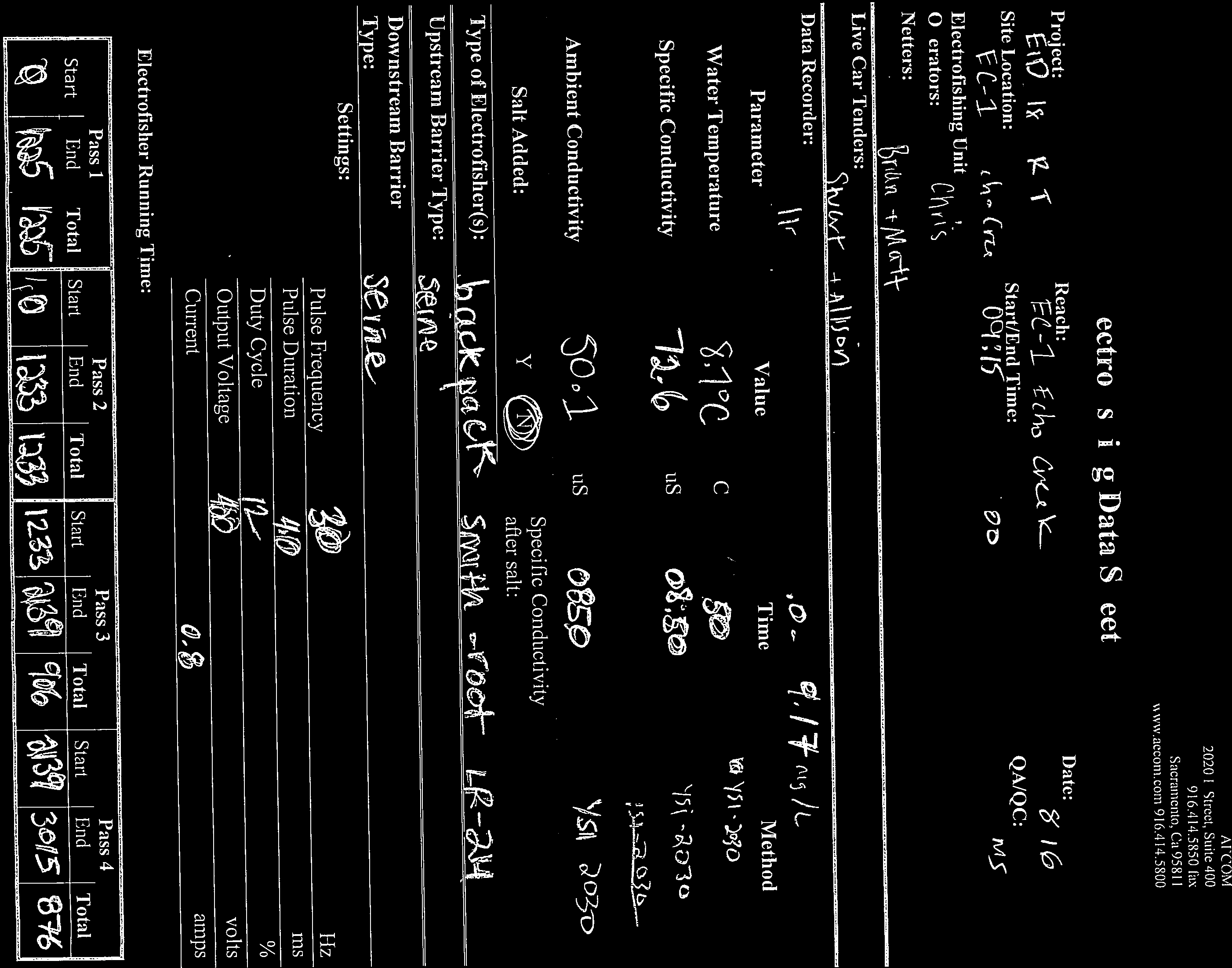
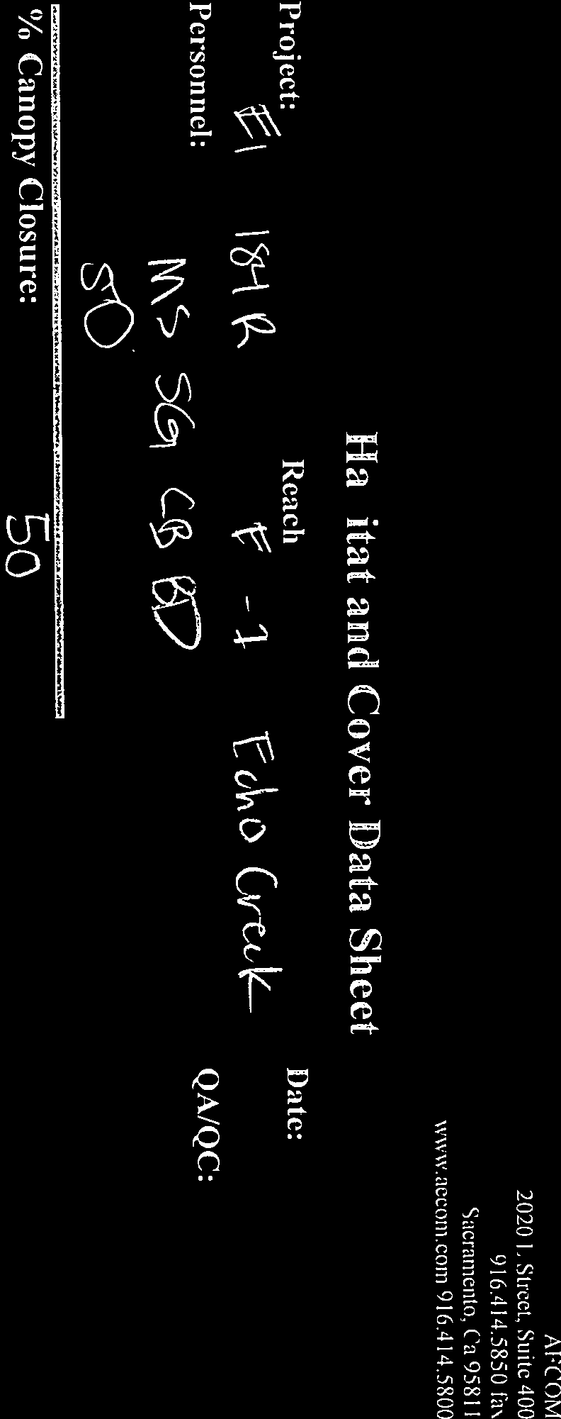
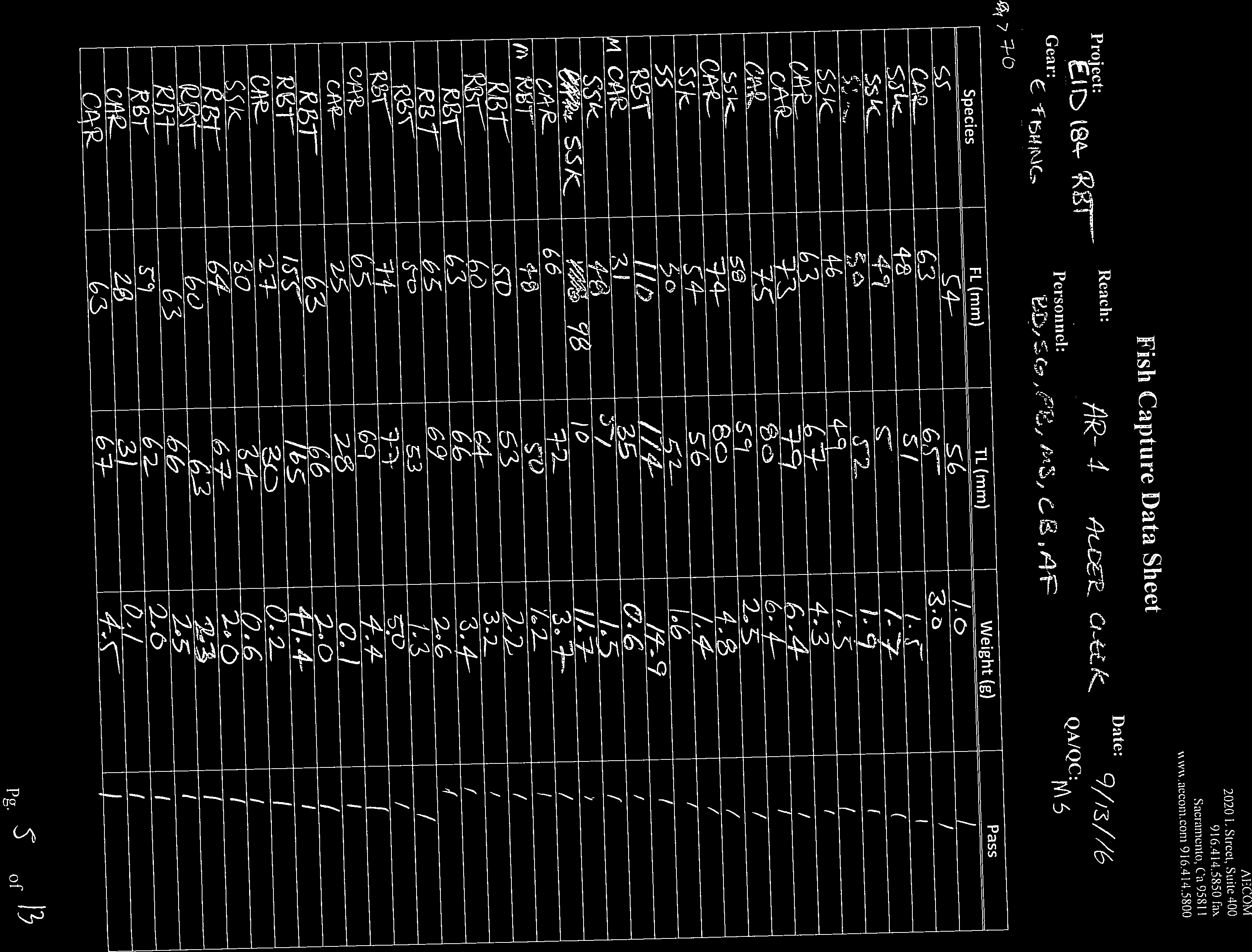
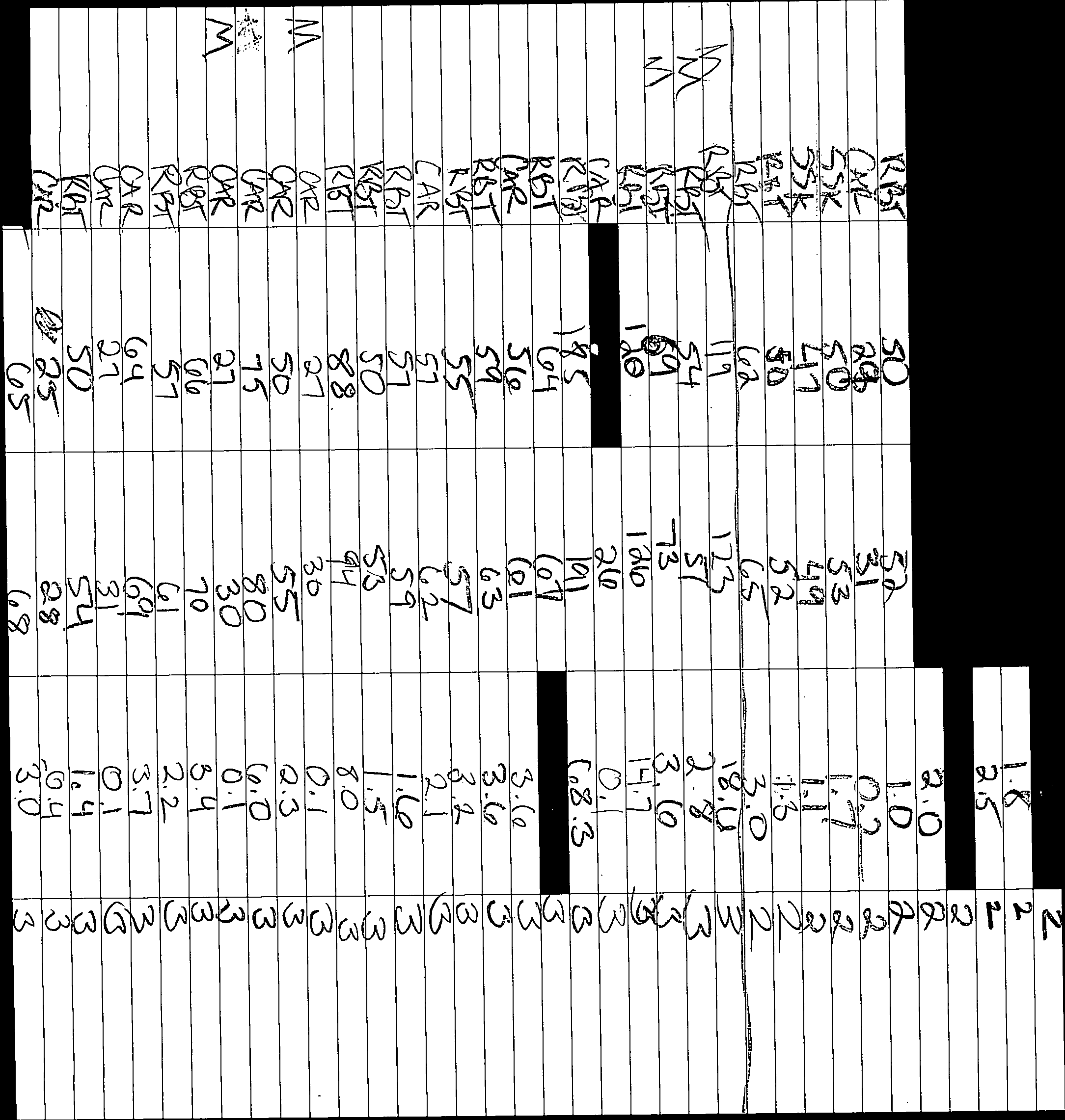
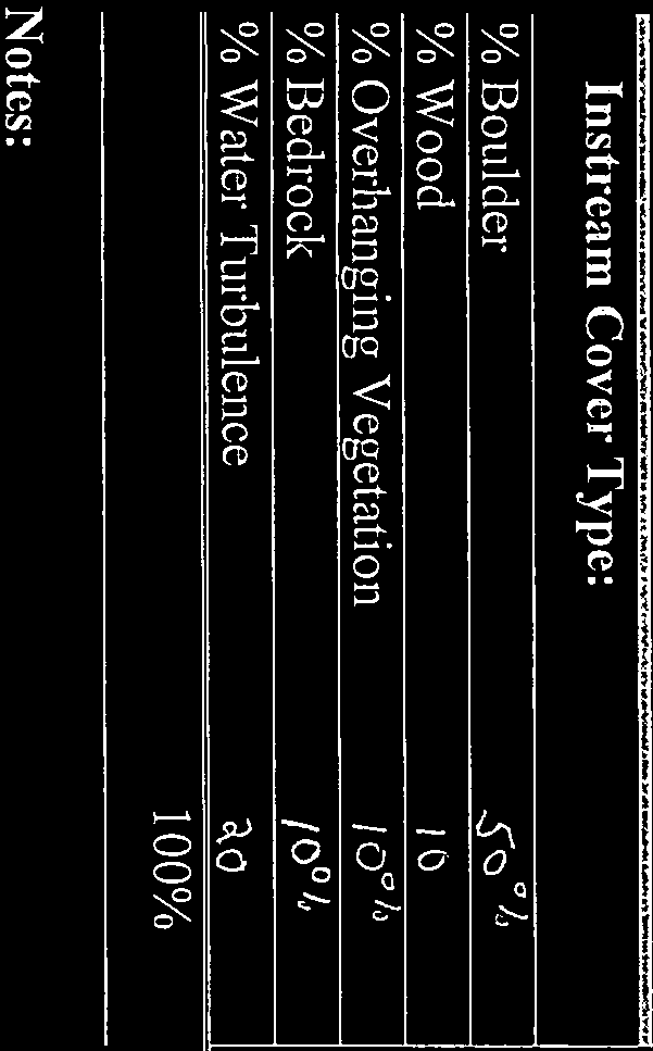
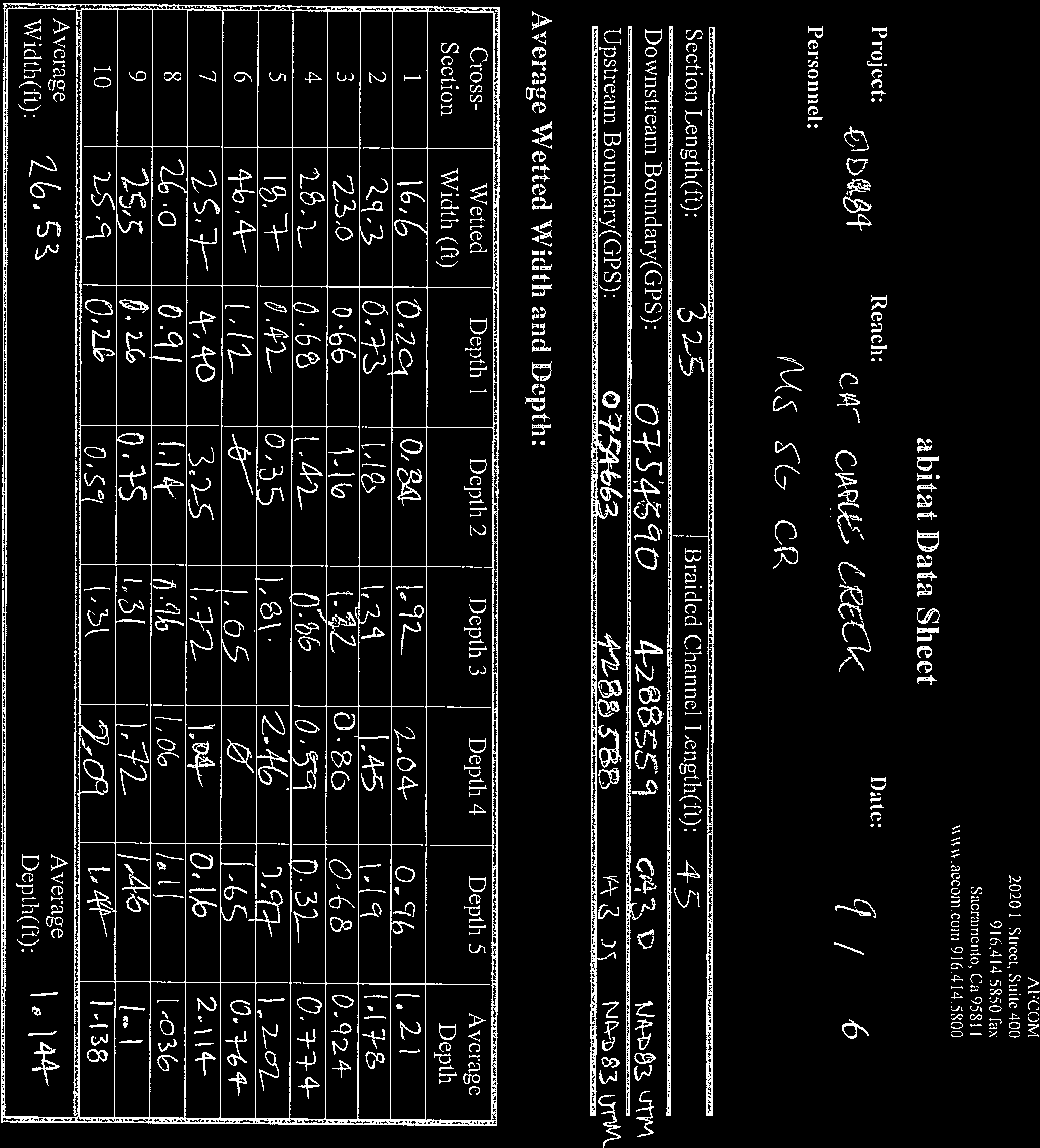
8 El Dorado Irrigation District, FERC Project No. 184 Rainbow Trout Monitoring METHODS Methods were consistent with those used in prior sampling years. Sites sampled in 2011 and 2012 were located in 2016 using GPS coordinates and site photos. Sampling site boundaries were established in approximately the same location as previous years, except when habitat and flow conditions required slight adjustments. In these instances, historical boundaries were moved slightly to accommodate effective sampling. 3.1 Data Collection Sampling site boundaries were established at natural habitat breaks or other logical positions for block net placement. Block nets were installed to ensure a closed population by preventing fish from moving in or out of the sampling reach. At Lower Alder Creek (AR-1), an upstream block net was not needed because a natural instream cascade provided a sufficient barrier to fish movement. The upstream and downstream boundaries were documented at all sites by recording GPS coordinates and taking photographs. Prior to beginning the electrofishing fish sampling effort, water quality parameters (water temperature, dissolved oxygen, and conductivity) were measured and recorded using an YSI Pro 2030 meter. Based on water quality parameters, backpack electrofishing unit settings were adjusted to maximize capture efficiency and minimize potential injury to fish. When conductivity was lower than the desired range for effective electrofishing, salt (5 pound salt blocks) was added at the upstream end of a sampling reach and allowed to dissolve and disperse throughout the reach prior to beginning electrofishing. Conductivity was monitored continuously after adding salt; electrofishing began when water conductivity was within the desired range. Sampling via multi-pass (or depletion) electrofishing consisted of applying an electrical current to the water using between one and three backpack electrofishing units, depending on the width of the reach, to temporarily immobilize fish to allow capture. Field crews began electrofishing at the downstream end of the sampling site and worked in a methodical, upstream direction. A pass is defined as one complete electrofishing sampling effort from the downstream boundary to the upstream boundary. During each pass, captured fish were placed in 5 gallon buckets filled with oxygenated water, and transported to and placed in an instream holding livewell located downstream of the sampling reach. At the completion of each pass, captured fish were identified to species, weighed (g), measured (fork and total length, mm), and placed in a separate instream holding livewell. Three passes were typically made per sampling site. A fourth pass was conducted when three passes were insufficient to generate a viable depletion curve. When sampling was complete and all captures were processed, fish were released back into the sampling reach taking care to distribute throughout the reach and in appropriate habitat. Physical habitat data were measured and recorded at each sampling site at the conclusion of electrofishing efforts. The length of each sampling reach was divided into ten equally spaced transects. Width and depth was measured at each transect. Flow measurements were taken at a point within each site determined to have the most laminar flow. Measured water velocities were multiplied to calculate discharge in cubic feet per second (cfs). In some instances, suitable habitat for flow measurements was not found within the 8
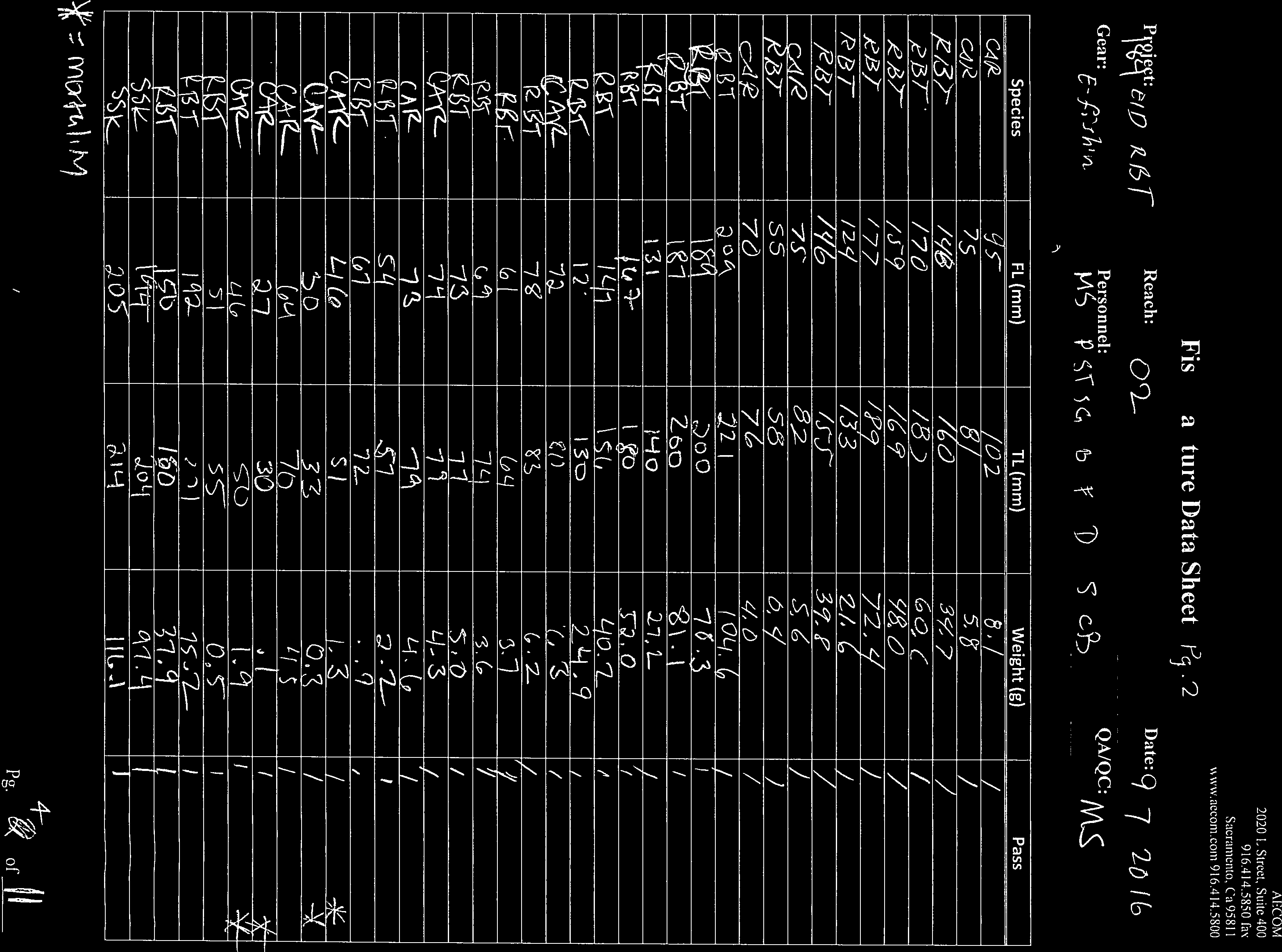
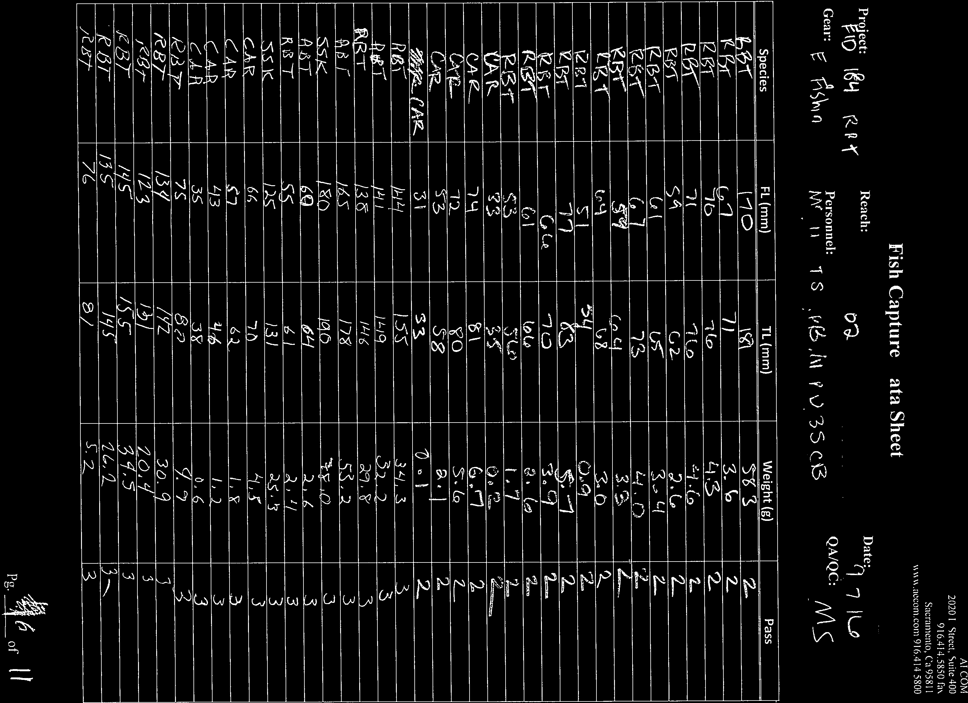
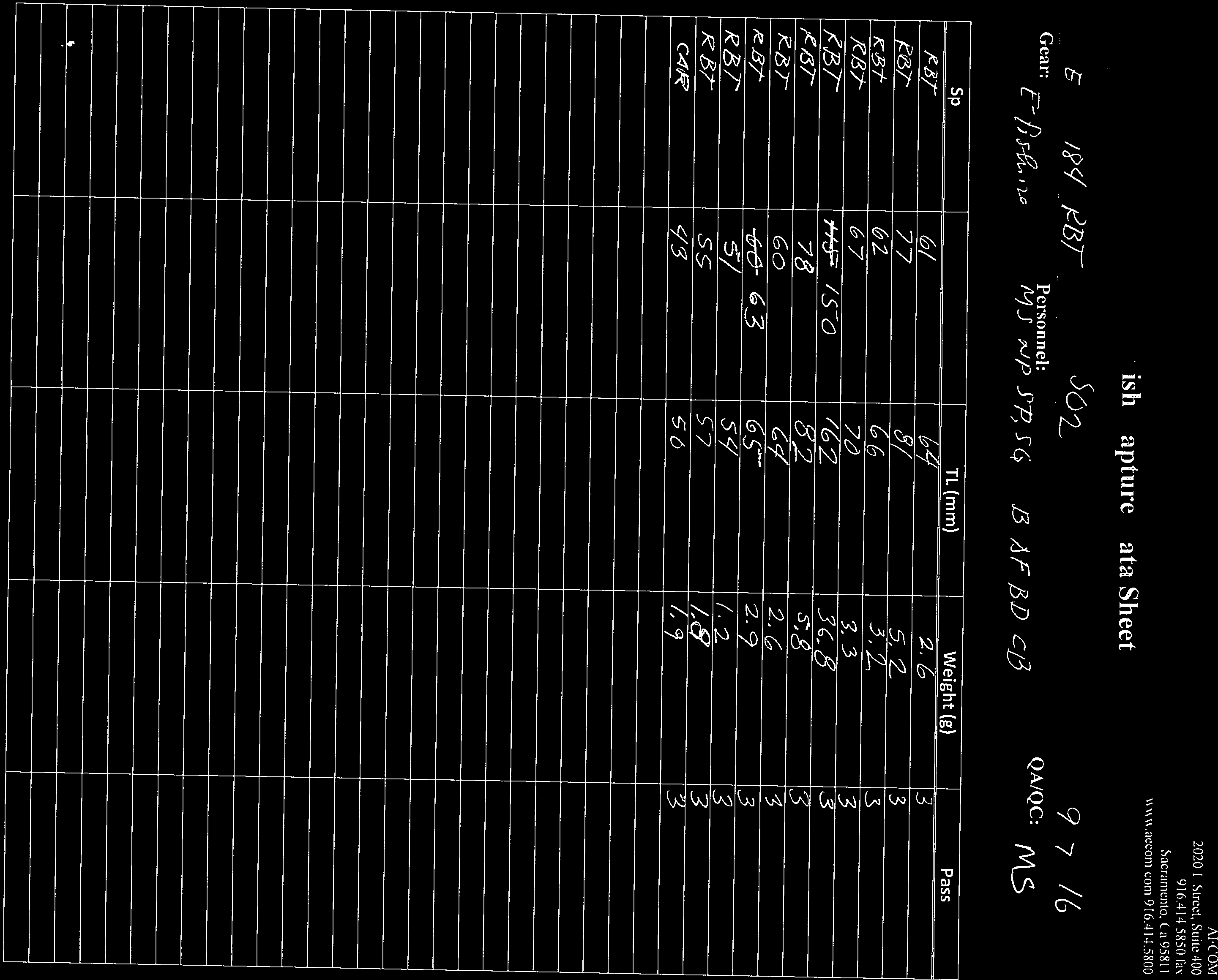
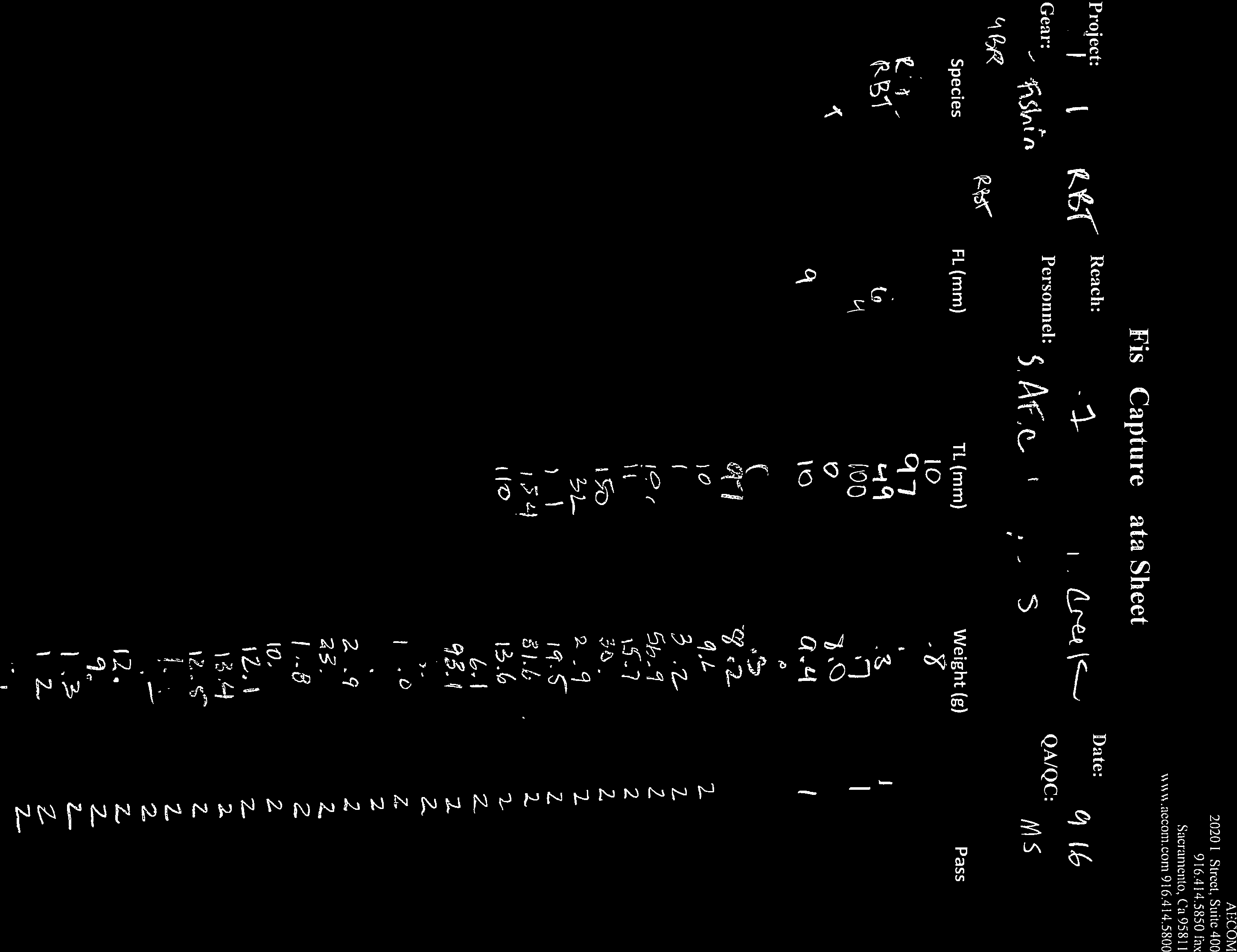
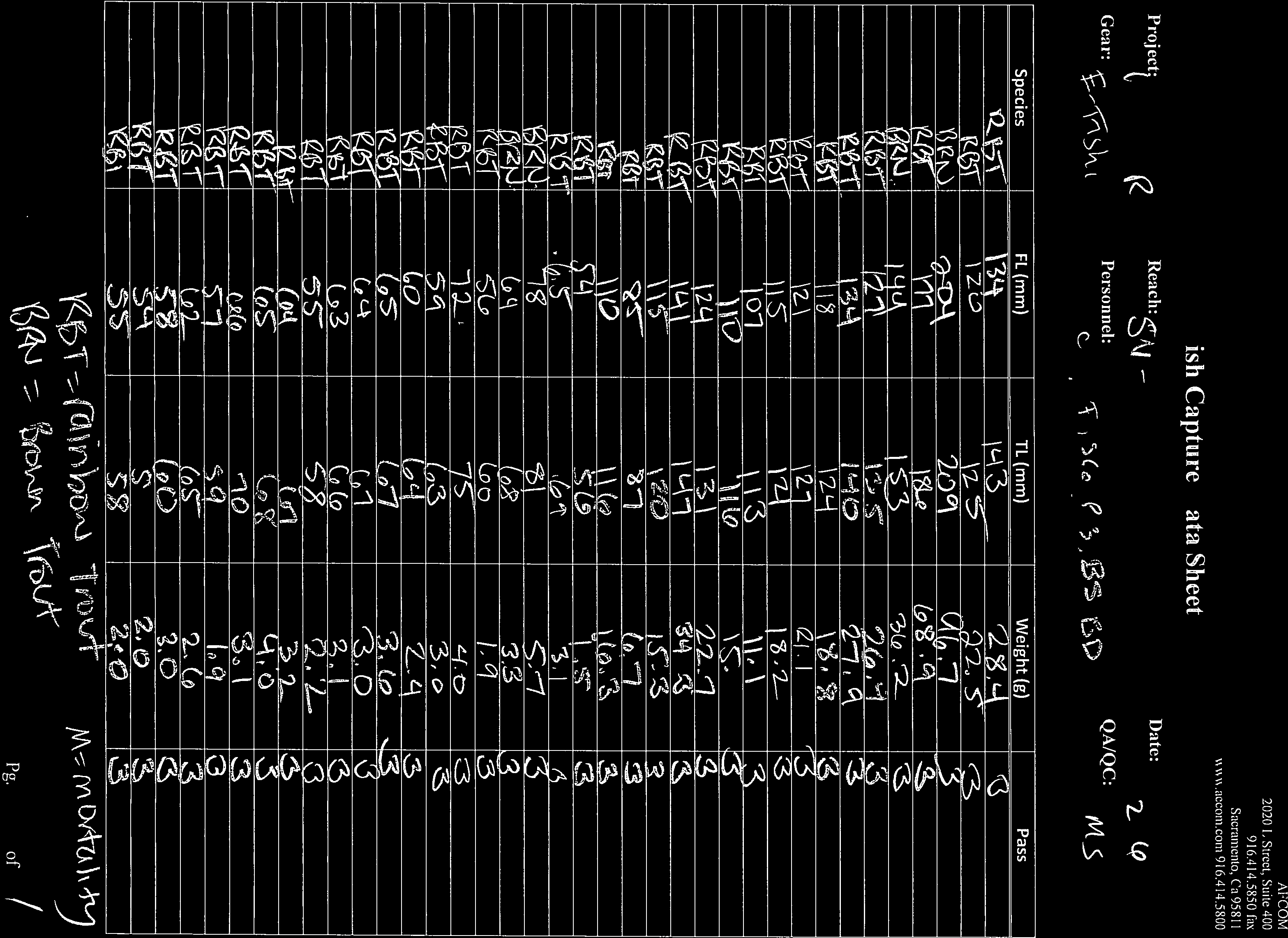
9 El Dorado Irrigation District, FERC Project No. 184 Rainbow Trout Monitoring 2016 site boundaries. In these cases, flow measurements were taken in the closest location outside the site boundary where suitable conditions existed. 3.2 Data Analysis Fish capture data, taken from field data sheets (Attachment B), were entered into an Excel database. Rainbow Trout capture data were then converted to comma separated values (CSV) files and analyzed using MicroFish 3.0 software. Population and total weight estimates generated by MicroFish 3.0 were used to calculate density and biomass values presented in this report. 9
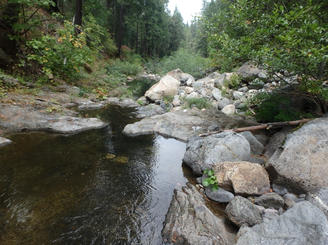
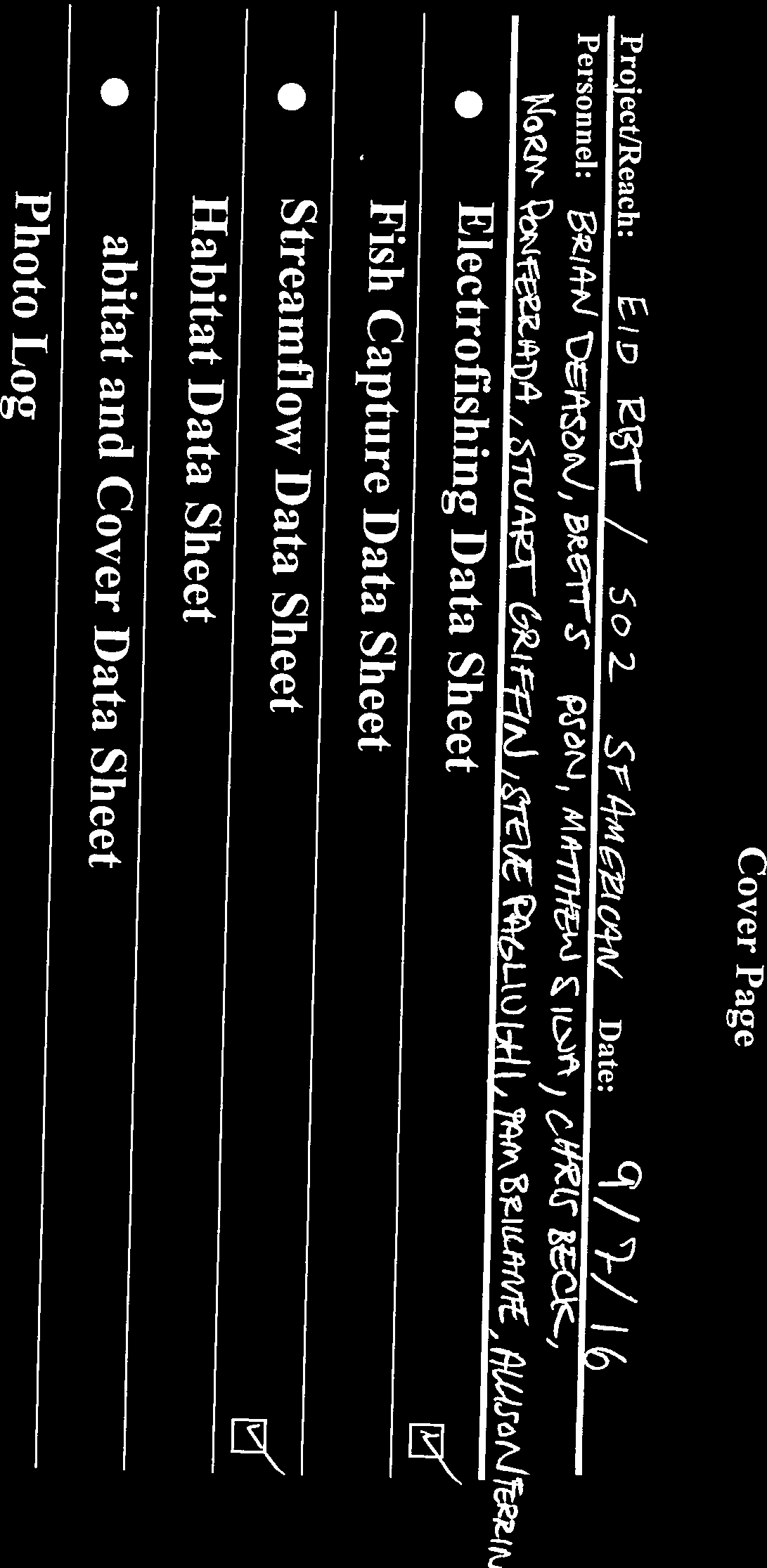
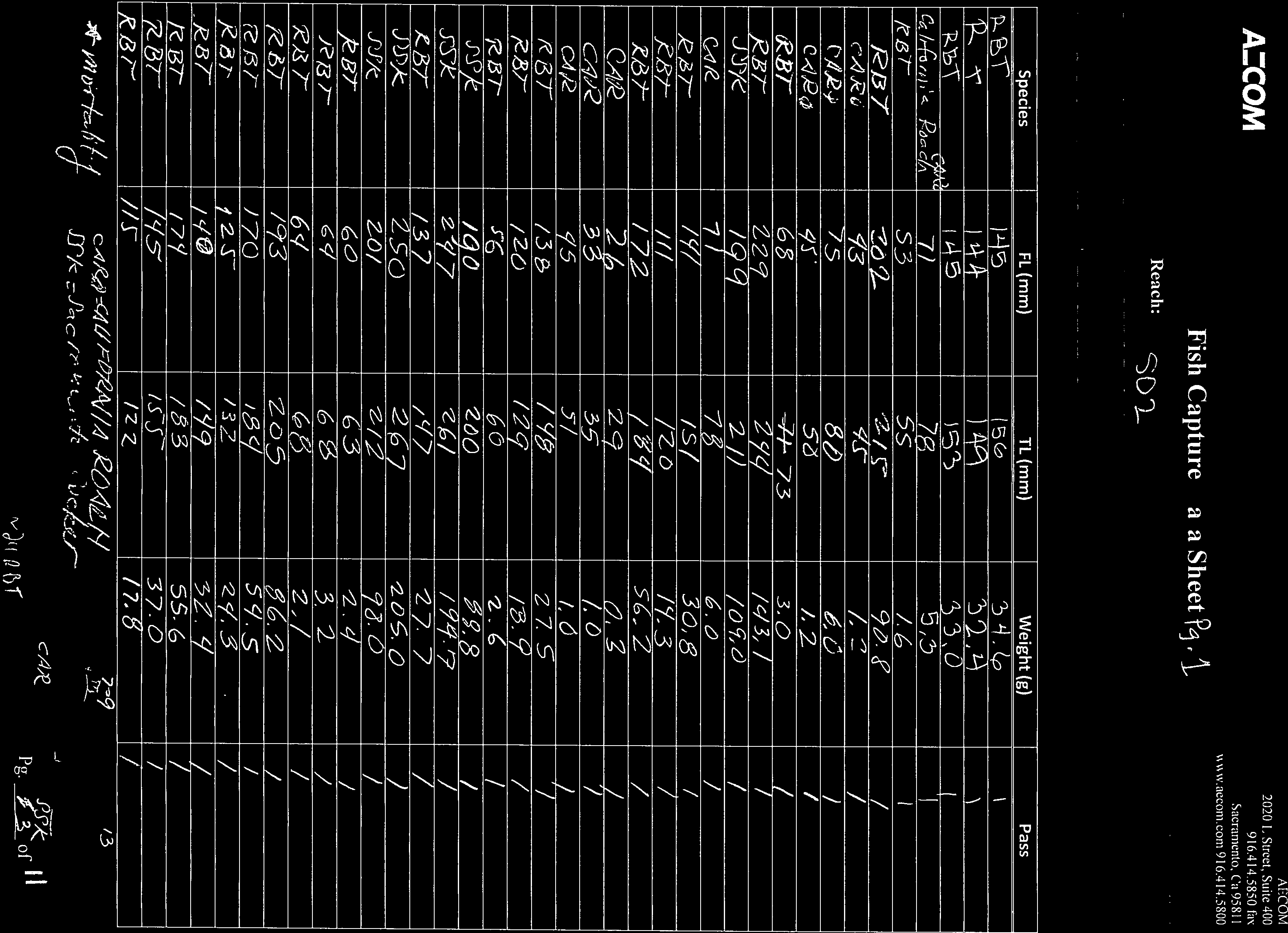
10 El Dorado Irrigation District, FERC Project No. 184 Rainbow Trout Monitoring RESULTS Results from the 2016 monitoring effort are presented in this report. Mean Rainbow Trout biomass and density estimates from the 2011 (Stillwater 2012) and the 2012 (ECORP 2013) monitoring efforts are presented in this report to show temporal change and evaluate how well targeted indices are being met in the context of the ecological resource objectives described in the Plan. Six fish species were observed among sampling sites and included Rainbow Trout, (Salmo trutta), (Salvelinus fontinalis), Sacramento (Catostomas occidentalis), California Roach (Hesperoleucus symmetricus), and Prickly Sculpin (Cottus asper). The majority of trout captured were Rainbow Trout, followed by Brown and Brook Trout. Results by sampling site are presented below. A summary of water quality parameters is shown in Table 2. Estimated Rainbow Trout densities and biomass are shown in Table 3 and in Figures 2 and 3. A summary of habitat parameters and habitat composition is shown in Table 4 and Table 5, respectively. 4.1 South Fork American River below Carpenter Creek (SO-2) The South Fork American River below Carpenter Creek was electrofished on September 7, The sampling site was moved roughly 20 meters downstream due to high flows through high gradient cascade habitat at the upstream end of the previously sampled reach. The site consisted of two river channels separated by a partially wetted gravel bar that extended the length of the reach. The two channels and gravel island were treated as one large braided channel for the electrofishing effort and the habitat assessment. Each electrofishing pass consisted of an upstream sampling effort through the entirety of the main channel (river left) followed by a similar effort on the side channel (river right). The sampling reach was feet (90.0 meters) in length with an average width of feet (37.7 meters; Table 4). Maximum depth was 2.7 feet and average depth was 0.8 feet. Predominant habitat types were pocket water (50%) and riffle (30%). Predominant substrate types were cobble (50%) and boulder (44%). Onsite discharge during sampling was 72.9 cfs compared to 70.6 cfs in 2011 and 20.0 cfs in Discharge recorded at the stream gauge located on South Fork of the American River below Kyburz (EID gage A-12; USGS ID ) at the time of sampling was 56.8 cfs. A total of 107 Rainbow Trout (152 in 2011 and 94 in 2012), 13 Sacramento Sucker, and 38 California Roach were captured. The total weight of Rainbow Trout was 2,769.4 g compared to 4,782 g in 2011 and 2,721.4 g in Rainbow Trout density was estimated at 2,557 fish/mile compared to 3,703 fish/mile in 2011 and 1,991 fish/mile in Rainbow Trout biomass was estimated at 9.7 lbs/acre compared to 20.6 lbs/acre in 2011 and 12.0 lbs/acre in Lower Echo Creek (EC-1) Lower Echo Creek was electrofished on September 8, Fish capture efficiency was less than optimal due to the high amount of large wood debris and logjams in the sampling reach (see photos, Attachment A). Fish were often immobilized by the electrical current but trapped within woody debris piles. For this reason, the Rainbow Trout depletion pattern after three passes was insufficient to generate a viable depletion curve, and thus, a fourth pass was conducted. 10
11 El Dorado Irrigation District, FERC Project No. 184 Rainbow Trout Monitoring 2016 The sampling reach was feet (95.0 meters) in length with an average width of 14.8 feet (4.5 meters; Table 4). Maximum depth was 1.3 feet and average depth was 0.3 feet. Predominant habitat types were run (60%) and backwater pool (25%). Predominant substrate types were cobble (50%) and gravel (28%). Flow within and near the sample reach was insufficient to register on field equipment. Discharge recorded at the stream gauge located at the outlet of Echo Lake (EID gage A-43) at the time of sampling was 0.2 cfs compared to 3.4 cfs in 2011 and 2.1 cfs in A total of 13 Rainbow Trout (5 in 2011 and 2 in 2012), 64 Brown Trout, and 93 Prickly Sculpin were captured. The total weight of Rainbow Trout was 136 g compared to g in 2011 and 78.3 g in Rainbow Trout density was estimated at 339 fish/mile compared to 143 fish/mile in 2011 and 72 fish/mile in Rainbow Trout biomass was estimated at 4.3 lbs/acre compared to 3.5 lbs/acre in 2011 and 2.4 lbs/acre in Lower Pyramid Creek (PY-1) Lower Pyramid Creek was electrofished on September 9, Similar to previous years, conductivity was too low to effectively capture fish via electrofishing. Therefore, salt was added prior to each pass and conductivity was closely monitored throughout the day (Table 2). The sampling reach was feet (92.6 meters) in length with an average width of 23.3 feet (7.1 meters; Table 4). Maximum depth was 1.4 feet and average depth was 0.7 feet. Predominant habitat types were run (50%) and riffle (25%). Predominant substrate types were cobble (45%) and bedrock (30%). Onsite flow measurements were not recorded. Discharge recorded at the stream gauge located on Pyramid Creek below US Highway 50 (EID gage A-40; USGS ID ) at the time of sampling was 3.4 cfs compared to 26.3 cfs in 2011 and 2.1 cfs in A total of 88 Rainbow Trout (40 in 2011 and 62 in 2012) and 5 Brown Trout were captured. The total weight of Rainbow Trout was 1,697.5 g compared to 1,017.7 in 2011 and g in Rainbow Trout density was estimated at 1,980 fish/mile compared to 2,509 fish/mile in 2011 and 1,073 fish/mile in Rainbow Trout biomass was estimated at 29.9 lbs/acre compared to 38.8 lbs/acre in 2011 and 8.7 lbs/acre in Silver Fork American River at Forgotten Flat (SV-4) Silver Fork American River at Forgotten Flat was electrofished on September 12, The sampling reach was feet (98.0 meters) in length with an average width of 36.1 feet (11.0 meters; Table 4) Maximum depth was 2.7 feet and average depth was 1.1 feet. Predominant habitat types were riffle (55%) and pocket water (30%). Predominant substrate types were cobble (35%) and bedrock (25%). Onsite discharge during sampling was 15.4 cfs compared to 12.7 cfs in 2011 (2012 discharge unavailable). Discharge recorded by EID at Silver Fork below Oyster Creek Confluence (EID gage A-9 + A-24) at the time of the 2016 sampling was 12.8 cfs. A total of 156 Rainbow Trout (83 in 2011 and 57 in 2012) and 29 Brown Trout were captured. The total weight of Rainbow Trout was 3,323.3 g compared to 2,338.2 g in 2011 and 1,112.9 in Rainbow Trout density was estimated at 3,760 fish/mile compared to 1,744 fish/mile in 2011 and 985 fish/mile in Rainbow Trout biomass was estimated at 40.1 lbs/acre compared to 27.4 lbs/acre in 2011 and 8.4 lbs/acre in
12 El Dorado Irrigation District, FERC Project No. 184 Rainbow Trout Monitoring Lower Alder Creek (AR-1) Lower Alder Creek was electrofished on September 13, A large pool (depths > 5 feet) located at the upstream end of the sampling reach was mostly inaccessible to electrofishing. Numerous fish, including trout, were observed but not captured in this pool. The sampling reach was feet (99.0 meters) in length with an average width of 13.5 feet (4.1 meters; Table 4). Maximum depth was 3.4 feet and average depth was 0.9 feet. Predominant habitat types were riffle (55%) and pool (15%). Predominant substrate types were cobble (40%) and boulder (25%). Onsite discharge during sampling was 0.5 cfs compared to 4.6 cfs in 2011 and 0.2 cfs in Discharge recorded by EID at Alder Creek below diversion (EID Station ID A-13) at the time of sampling was 0.4 cfs. A total of 124 Rainbow Trout (165 in 2011 and 67 in 2012), 46 Sacramento Suckers, and 64 California Roach were captured. The total weight of Rainbow Trout was g compared to 2,710.3 g in g in Rainbow Trout density was estimated at 2,339 fish/mile compared to 3,251 fish/mile in 2011 and 1,288 fish/mile in Rainbow Trout biomass was estimated at 15.3 lbs/acre compared to 42.2 lbs/acre in lbs/acre in Caples Creek below Kirkwood Creek (CA-3) Caples Creek was electrofished on September 14, Much of the habitat encountered in this reach was difficult or impossible to effectively sample because many of the banks were undercut as much as 5 feet and water depths in some places were greater than 4 feet. The sampling reach was feet (99.0 meters) in length with an average width of 26.2 feet (8.0 meters; Table 4). Maximum depth was 4.4 feet and average depth was 1.1 feet. Predominant habitat types were run (30%) and lateral scour pool (30%). Predominant substrate types were gravel (45%) and sand (35%). Onsite discharge during sampling was 43.2 cfs compared to 26.8 cfs in cfs in Discharge recorded by EID at Caples Creek at Caples Lake outlet (EID gage A-6; USGS ID ) at the time of sampling was 30.4 cfs. A total of 48 Brook Trout and 2 Brown Trout were captured. No Rainbow Trout were captured at this site in 2016; therefore, density and biomass indices were not calculated. No Rainbow Trout were captured in 2011 and 4 were captured in
13 El Dorado Irrigation District, FERC Project No. 184 Rainbow Trout Monitoring 2016 Table 2. Water quality parameters, September Sampling Site South Fork American River (SO-2) Lower Echo Creek (EC-1) Lower Pyramid Creek (PY-1) Silver Fork American River (SV-4) Lower Alder Creek (AR-1) Caples Creek (CA-3) Water Temperature ( C) Dissolved Oxygen (% saturation) Dissolved Oxygen (mg/l) Conductivity (us) Salt Added Per Pass (5lb blocks) Conductivity After Salt Added (us) 12.7 n/a n/a n/a 12.0 n/a Table 3. Rainbow Trout density, biomass, and biomass indices, September Sampling Site South Fork American River (SO-2) Lower Echo Creek (EC-1) Lower Pyramid Creek (PY-1) Silver Fork American River (SV-4) Lower Alder Creek (AR-1) Caples Creek (CA-3) Depletion Pattern Total numbers captured Total Weight (g) Estimated Density (fish/mile) Estimated Weight in Reach (g) Estimated Biomass (lbs/acre) Rainbow Trout Biomass Indices (lbs/acre) a 51, 35, , ,557 3, , 4, 5, , 38, , ,980 2, ,47, , ,760 4, , 37, , , 0, a Biomass indices from Appendix B, Section 1 of the El Dorado Relicensing Settlement Agreement (biomass indices were developed for Rainbow Trout only) 13
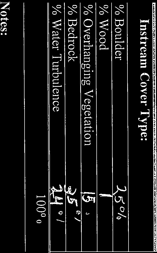
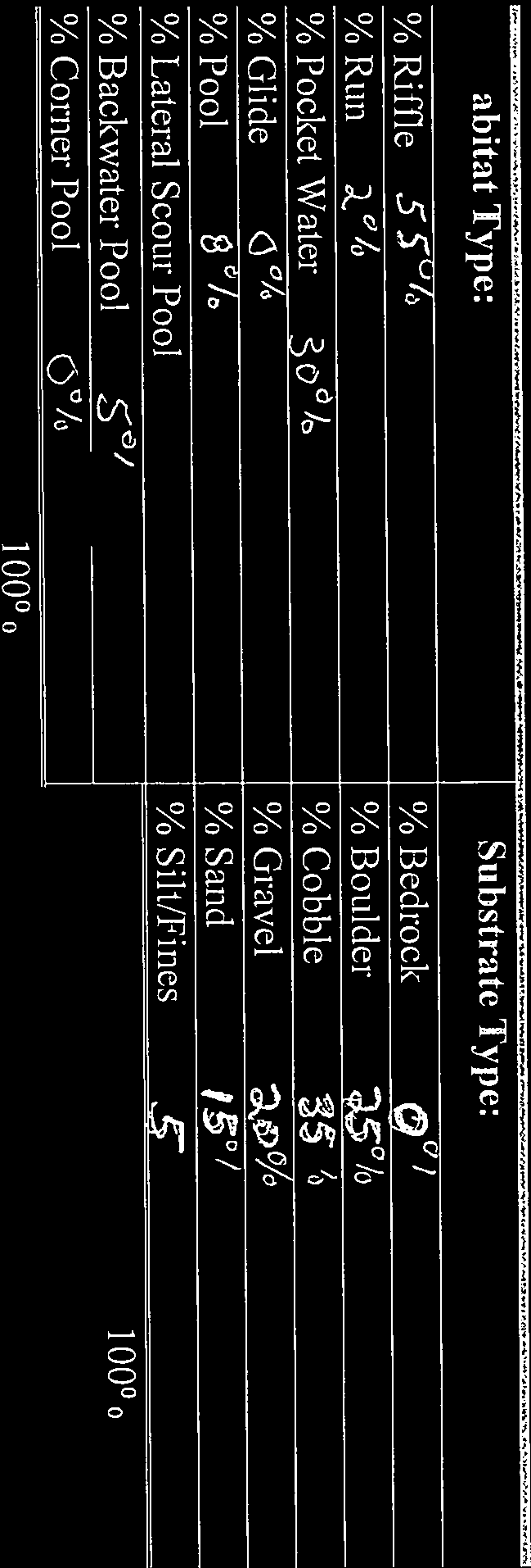
14 El Dorado Irrigation District, FERC Project No. 184 Rainbow Trout Monitoring 2016 Table 4. Physical habitat characteristics, September Reach South Fork American River (SO-2) Lower Echo Creek (EC-1) Lower Pyramid Creek (PY-1) Silver Fork American River (SV-4) Lower Alder Creek (AR-1) Caples Creek (CA-3) Date Sampled Length (m) Average Width (m) Surface Area (acre) Maximum Depth (ft) Average Depth (ft) Measured Discharge (cfs) Discharge at Gaging Station (cfs) 09/07/ /08/ n/a /09/ n/a /12/ /13/ /14/ Table 5. Habitat type composition, September Reach Riffle (%) Run (%) South Fork American River (SO-2) Lower Echo Creek (EC-1) Lower Pyramid Creek (PY-1) Silver Fork American River (SV-4) Lower Alder Creek (AR-1) Caples Creek (CA-3) Pocket Water (%) Glide (%) Pool (%) Lateral Scour Pool (%) Backwater Pool (%) Corner Pool (%)
15 El Dorado Irrigation District, FERC Project No. 184 Rainbow Trout Monitoring Density (fish per mile) South Fork American River (SO-2) Lower Echo Creek (EC-1) Lower Pyramid Creek (PY-1) Silver Fork American River (SV-4) Lower Alder Creek (AR-1) Caples Creek (CA-3) Stream Reach Figure 2. Rainbow Trout density estimates (fish/mile), September
16 El Dorado Irrigation District, FERC Project No. 184 Rainbow Trout Monitoring Biomass (lbs/acre) South Fork American River (SO-2) Lower Echo Creek (EC-1) Lower Pyramid Creek (PY-1) Silver Fork American River (SV- 4) Lower Alder Creek (AR-1) Caples Creek (CA-3) Stream Reach Figure 3. Rainbow Trout biomass estimates (pounds/acre), September
17 El Dorado Irrigation District, FERC Project No. 184 Rainbow Trout Monitoring CONCLUSIONS The next rainbow trout fish population monitoring effort is scheduled for 2017; the mean biomass for 2016 and 2017 monitoring efforts will be used to evaluate if targeted rainbow trout biomass values are being met for the project reaches. Because the rainbow trout biomass estimates in this report are for 2016 only, any conclusion as to whether the ecological resource objectives are being achieved would be premature. However, the 2016 rainbow trout biomass estimates and associated biomass indices are summarized here as a general reference. The biomass estimates (lbs/acre) from the 2016 sampling efforts are higher than biomass indices at two sites: Lower Pyramid Creek (PY-1) and Silver Fork American River at Forgotten Flat (SV- 4). The biomass estimates (lbs/acre) from the 2016 sampling efforts are lower than biomass indices at four sites: South Fork American River below Carpenter Creek (SO-2), Lower Echo Creek (EC-1), Lower Alder Creek (AR-1), and Caples Creek below Kirkwood Creek (CA-3). The 2016 biomass estimates are higher than the mean biomass estimate from the sampling efforts at three sites: Lower Pyramid Creek (PY-1), Silver Fork American River at Forgotten Flat (SV-4), and Lower Echo Creek (EC-1). For two sites, South Fork American River below Carpenter Creek (SO-2) and Lower Alder Creek (AR-1), the 2016 biomass estimates are more than 20% less than the mean biomass estimate from sampling efforts. The 2016 biomass estimate for Caples Creek below Kirkwood Creek (CA-3) is zero because Rainbow Trout were not captured in this reach during the 2016 sampling efforts. 17
18 El Dorado Irrigation District, FERC Project No. 184 Rainbow Trout Monitoring REFERENCES ECORP Consulting, Inc Fisheries data report for Project-affected stream reaches, El Dorado Irrigation District, Hydroelectric Project 184. Prepared by ECORP Consulting, Inc., Rocklin, California for El Dorado Irrigation District, Placerville, California. ECORP Consulting Inc El Dorado Irrigation District, FERC Project No. 184, Rainbow Trout Monitoring Prepared by ECORP Consulting, Inc., Rocklin, California for El Dorado Irrigation District, Placerville, California. EID (El Dorado Irrigation District) El Dorado Hydroelectric Project FERC Project 184, Rainbow Trout Monitoring Plan. El Dorado Irrigation District, Placerville, CA. Stillwater Sciences El Dorado Irrigation District, Project No. 184: rainbow trout monitoring Prepared by Stillwater Sciences, Davis, California for El Dorado Irrigation District, Placerville, California. 18
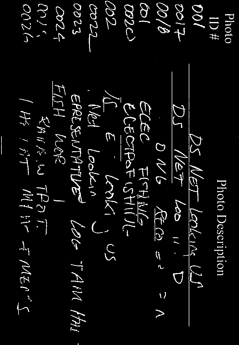
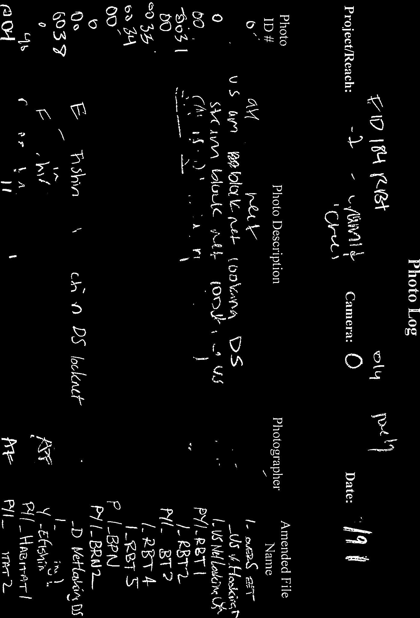
19 Attachment A Project Photos 19


20 South Fork American River (SO-2), river left channel. Downstream block net facing upstream. South Fork American River (SO-2), river left channel. Downstream block net facing downstream. 20


21 South Fork American River (SO-2), river right channel. Downstream block net facing upstream. South Fork American River (SO-2), river right channel. Downstream block net facing downstream. 21


22 South Fork American River (SO-2), river left channel. Upstream block net facing upstream. South Fork American River (SO-2), river left channel. Upstream block net facing downstream. 22


23 South Fork American River (SO-2), river right channel. Upstream block net facing upstream. South Fork American River (SO-2), river left channel. Upstream block net facing downstream. 23


24 Lower Echo Creek (EC-1). Downstream block net facing upstream. Lower Echo Creek (EC-1). Downstream block net facing downstream. 24


25 Lower Echo Creek (EC-1). Upstream block net facing upstream. Lower Echo Creek (EC-1). Upstream block net facing downstream. 25


26 Lower Echo Creek (EC-1), mid-reach. Photo shows representative logjam. Lower Echo Creek (EC-1), mid-reach. Photo shows representative habitat. 26


27 Lower Pyramid Creek (PY-1). Downstream block net facing downstream. Lower Pyramid Creek (PY-1). Upstream block net facing upstream. 27

,")
28 Lower Pyramid Creek (PY-1). Upstream block net facing downstream. Lower Pyramid Creek (PY-1), mid-reach. Photo shows representative habitat. 28


29 Silver Fork American River (SV-4). Downstream block net facing upstream. Silver Fork American River (SV-4). Downstream block net facing downstream. 29


30 Silver Fork American River (SV-4). Upstream block net facing upstream. Silver Fork American River (SV-4). Upstream block net facing downstream. 30


31 Silver Fork American River (SV-4), mid-reach. Photo shows representative habitat. Silver Fork American River (SV-4). Representative photo of Rainbow Trout captured within reach. 31


32 Lower Alder Creek (AR-1). Downstream block net facing upstream. Lower Alder Creek (AR-1). Downstream block net facing downstream. 32

33 Lower Alder Creek (AR-1). Upstream site boundary barrier facing upstream. Lower Alder Creek (AR-1). Upstream site boundary barrier facing downstream. 33


34 Lower Alder Creek (AR-1). Mid-reach. Representative photo of habitat. Lower Alder Creek (AR-1). Representative photo of Rainbow Trout captured within reach. 34


35 Caples Creek (CA-3). Downstream block net facing upstream. Caples Creek (CA-3). Downstream block net facing downstream. 35


36 Caples Creek (CA-3). Upstream block net facing upstream. Caples Creek (CA-3). Upstream block net facing downstream. 36


37 Caples Creek (CA-3). Mid-reach. Electrofishing. Caples Creek (CA-3). Mid-reach. Photo shows representative habitat. 37
38 Attachment B Field Data Sheets 38

39


40
41
42

43
44
45


46


47


48


49


50
51

52

53

54


55


56


57

58


59

60


61


62

63

64


65

66


67

68

69


70


71

72


73
74


75


76


77

78
79


80

81

82
83

84


85


86


87


88

89


90


91


92

93


94


95

96
97


98

99
COMPLIANCE REPORT MUDDY HOLLOW CULVERT REMOVAL FILE NUMBER 25358N
 COMPLIANCE REPORT MUDDY HOLLOW CULVERT REMOVAL FILE NUMBER 25358N Submitted by the National Park Service Point Reyes National Seashore Point Reyes Station, California, 94956 Project Description: Muddy
121 FERC 62,167 UNITED STATES OF AMERICA FEDERAL ENERGY REGULATORY COMMISSION. Public Utility District No. 1 of Project No. 637-044 Chelan County
 121 FERC 62,167 UNITED STATES OF AMERICA FEDERAL ENERGY REGULATORY COMMISSION Public Utility District No. 1 of Project No. 637-044 Chelan County ORDER MODIFYING AND APPROVING LAKE CHELAN FISHERY PLAN,
NID statement Agreement Disagreement Auburn Ravine: During irrigation and nonirrigation
 NID statement Agreement Disagreement Auburn Ravine: 1. NID will not divert the natural flow during times when the flow as measured at NID s Highway 65 gage is less than 8 cfs provided that during those
A Reconnaissance Survey Of Le Moray Lake #3
 A Reconnaissance Survey Of Le Moray Lake #3 A. R. Langston and A. R. McLean 1998 PWFWCP Report No. 136 The Peace/Williston Fish & Wildlife Compensation Program is a cooperative venture of BC Hydro and
Thin Air and Thick Ice Unusual Challenges at a High Elevation Hydro Plant
 Thin Air and Thick Ice Unusual Challenges at a High Elevation Hydro Plant By Ginger Gillin, John Pizzimenti, and Doug Foss, GEI Consultants, Inc., USA, and Jon Jourdonnais, PPL Montana, USA. Abstract The
PROJECT STATUS REPORT. Development of microhabitat suitability criteria for fry and juvenile salmonids of the Trinity River
 PROJECT STATUS REPORT Development of microhabitat suitability criteria for fry and juvenile salmonids of the Trinity River Prepared for: Trinity River Restoration Program P.O. Box 13 1313 South Main St.
TENNESSEE GAS PIPELINE COMPANY, L.L.C.
 TENNESSEE GAS PIPELINE COMPANY, L.L.C. HYDROLOGIC & HYDRAULIC CALCULATIONS FOR WATERBODIES CROSSED BY CONNECTICUT PIPELINE EXPANSION PROJECT CONNECTICUT LOOP Submitted by: Tennessee Gas Pipeline Company,
Sand and Silt Removal from Salmonid Streams
 Sand and Silt Removal from Salmonid Streams Stream bank erosion Poor land use practices Sources of Sand and Silt Impacts of Sand and Silt Interstitial spaces infilled Little or no flow through the streambed
ROGUE RIVER SPRING CHINOOK SALMON CONSERVATION PLAN. Evaluation of spring Chinook salmon spawning in Big Butte Creek, 2008
 ROGUE RIVER SPRING CHINOOK SALMON CONSERVATION PLAN Evaluation of spring Chinook salmon spawning in Big Butte Creek, 28 Rogue Watershed District Oregon Department of Fish and Wildlife March 29 Introduction
HCP Team Meeting. November 18, 2015. icfi.com
 HCP Team Meeting November 18, 2015 icfi.com 1 Welcome and Introductions Where are we in the HCP process Hydrology modeling update Native fish survey Fish translocation Finalize covered activities Next
Black Canyon Hydroelectric Project FERC Project No. P-14110 Proposed Fish Passage Study Plan September 2012
 Black Canyon Hydroelectric Project FERC Project No. P-14110 Proposed Fish Passage Study Plan September 2012 Prepared for Black Canyon Hydro, LLC 3633 Alderwood Avenue Bellingham, WA 98225 Table of Contents
How To Check For Scour At A Bridge
 Case Studies Bridge Scour Inspection and Repair Edward P. Foltyn, P.E. Senior Hydraulic Engineer ODOT Bridge Unit 2013 PNW Bridge Inspectors Conference April 2013 REFERENCES Stream Stability at Highway
Habitat Quality, Rainbow Trout Occurrence, and Steelhead Recovery Potential Upstream of Searsville Dam
 Habitat Quality, Rainbow Trout Occurrence, and Steelhead Recovery Potential Upstream of Searsville Dam Prepared by: Matt Stoecker Biologist Owner Stoecker Ecological December 19, 2014 Table of Contents
Stream Rehabilitation Concepts, Guidelines and Examples. Objectives. Pierre Y. Julien. Three Laws of Stream Restoration
 Stream Rehabilitation Concepts, Guidelines and Examples Pierre Y. Julien Wuhan 2005 Objectives Part I - Stream restoration and rehabilitation: 1. Present and discuss important concepts, laws, criteria
Youghiogheny River From Confluence, Pa to Indian Creek Fayette and Somerset Counties
 Pennsylvania Fish & Boat Commission Biologist Report Youghiogheny River From Confluence, Pa to Indian Creek Fayette and Somerset Counties August 2012 Electrofishing Survey Originating in the mountains
Monitoring the Benefits of Instream Habitat Diversity. Entiat River, Chelan County, Washington
 Monitoring the Benefits of Instream Habitat Diversity Entiat River, Chelan County, Washington Bureau of Reclamation Bonneville Power Administration May 2013 This is an update of the report that first occurred
Yuba River Development Project FERC Project No. 2246
 TECHNICAL MEMORANDUM 3-3 Special-Status Mollusks September 2012 2012, Yuba County Water Agency All Rights Reserved TECHNICAL MEMORANDUM 3-3 EXECUTIVE SUMMARY In July 2012, Yuba County Water Agency (YCWA
Lecture 4: Streamflow and Stream Gauging
 Lecture 4: Streamflow and Stream Gauging Key Questions 1. What is stream discharge and what controls its magnitude? 2. What is a hydrograph? 3. Where is the velocity highest in a stream? 4. Where is the
Year 2 7-15-10 Post Restoration Monitoring Summary Rock Creek Project Monitoring and Analysis conducted by Bio-Surveys,LLC. Contact: strask@casco.
 Year 2 7-15-10 Post Restoration Monitoring Summary Rock Creek Project Monitoring and Analysis conducted by Bio-Surveys,LLC. Contact: strask@casco.net Project Sponsors include: The City of Corvallis Oregon
Prattsville Berm Removal Project. 1.0 Project Location
 Prattsville Berm Removal Project 1.0 Project Location The project site is located between the New York State Route 23 Bridge over the Schoharie Creek and the Schoharie Reservoir. The restoration plan encompassed
Skaguay Reservoir. FISH SURVEY AND MANAGEMENT DATA Greg A. Policky - Aquatic Biologist (Salida) greg.policky@state.co.
 greg.policky@state.co.") FISH SURVEY AND MANAGEMENT DATA (Salida) greg.policky@state.co.us / 719-530-5525 General Information: Skaguay Reservoir, a 114 acre impoundment, offers good fishing for rainbow and brown trout with an
FISH SURVEY AND MANAGEMENT DATA (Salida) greg.policky@state.co.us / 719-530-5525 General Information: Skaguay Reservoir, a 114 acre impoundment, offers good fishing for rainbow and brown trout with an
CHAPTER 2 HYDRAULICS OF SEWERS
 CHAPTER 2 HYDRAULICS OF SEWERS SANITARY SEWERS The hydraulic design procedure for sewers requires: 1. Determination of Sewer System Type 2. Determination of Design Flow 3. Selection of Pipe Size 4. Determination
Index-Velocity Rating Development (Calibration) for H-ADCP Real-Time Discharge Monitoring in Open Channels
 for H-ADCP Real-Time Discharge Monitoring in Open Channels") Index-Velocity Rating Development (Calibration) for H-ADCP Real-Time Discharge Monitoring in Open Channels Hening Huang Teledyne RD Instruments, Inc., 14020 Stowe Drive, Poway, CA. 92064, USA (Tel: 858-842-2600,
Index-Velocity Rating Development (Calibration) for H-ADCP Real-Time Discharge Monitoring in Open Channels Hening Huang Teledyne RD Instruments, Inc., 14020 Stowe Drive, Poway, CA. 92064, USA (Tel: 858-842-2600,
Statement of Qualifications for Natural Resource Management Services October 2014
 Statement of Qualifications for Natural Resource Management Services October 2014 Prepared By: Michael Zenthoefer Point Environmental LLC 911 N Birch ST Canby, OR 97013 541 207 8441 mikez@pointenv.com
4. Environmental Impacts Assessment and Remediation Targets
 4. Environmental Impacts Assessment and Remediation Targets 4.1 Environmental Impacts Significant additional development in the Alder Creek watershed is not anticipated at this time; however, there are
CLIFTY CREEK PLANT MADISON, INDIANA
 2015 DAM AND DIKE INSPECTION REPORT GERS-15-018 CLIFTY CREEK PLANT MADISON, INDIANA PREPARED BY GEOTECHNICAL ENGINEERING AEP SERVICE CORPORATION 1 RIVERSIDE PLAZA COLUMBUS, OHIO Annual Dam and Dike Inspection
Prepared by: Siskiyou Research Group P.O. Box 2550 Cave Junction, OR 97523. For Public Review
 Prospect No. 3 Hydroelectric Project FERC Project No. P-2337 Initial Study Report: Fish Habitat (South Fork Rogue River 2014 Level II Stream Survey Report) May 2015 Prepared by: Siskiyou Research Group
https://orm.usace.army.mil/orm2/f?p=106:34:4198546103662037::no::
 Page 1 of 6 APPROVED JURISDICTIONAL DETERMINATION FORM U.S. Army Corps of Engineers JD Status: DRAFT SECTION I: BACKGROUND INFORMATION A. REPORT COMPLETION DATE FOR APPROVED JURISDICTIONAL DETERMINATION
Bull Run River. Water Temperature Evaluation. Prepared by: City of Portland Bureau of Water Works Portland, Oregon
 Bull Run River Water Temperature Evaluation Prepared by: City of Portland Bureau of Water Works Portland, Oregon June 2004 Contents Page Preface... 1 Report Purpose... 1 Report Organization... 1 Executive
APPENDIX F. Baker County. Mason Dam Hydroelectric Project FERC No. P-12686. Turbidity Monitoring Plan
 APPENDIX F Baker County Mason Dam Hydroelectric Project FERC No. P-12686 Turbidity Monitoring Plan April 2011 857 Table of Contents 1.0 Introduction 1 2.0 Purpose and Scope 2 3.0 Turbidity Monitoring and
 Coldwater Heritage Partnership Implementation Grant Final Report Morrison Run Watershed Restoration Project Western Pennsylvania Conservancy Project Summary The goal of the Morrison Run Watershed Restoration
Columbia River Project Water Use Plan. Monitoring Program Terms of Reference
 Columbia River Project Water Use Plan Revelstoke Flow Management Plan Monitoring Program Terms of Reference CLBMON-15a Middle Columbia River Physical Habitat Monitoring Revision January 29, 2015 Monitoring
Upper Pitt River Water Power Project Project Description Appendix I - Photographs
 Upper Pitt River Water Power Project Project Description Appendix I - Photographs Photo 1. Boise Creek Reach 3 at 1+223 m: typical fish habitat where the diversion reach overlaps with anadromous fish habitat.
2.0 BASIC CONCEPTS OF OPEN CHANNEL FLOW MEASUREMENT
 2.0 BASIC CONCEPTS OF OPEN CHANNEL FLOW MEASUREMENT Open channel flow is defined as flow in any channel where the liquid flows with a free surface. Open channel flow is not under pressure; gravity is the
Stream Channel Cross Sections for a Reach of the Boise River in Ada County, Idaho
 U.S. Department of the Interior U.S. Geological Survey In cooperation with Federal Emergency Management Agency, City of Boise, City of Garden City, City of Eagle, and Ada County Stream Channel Cross Sections
PRECIPITATION AND EVAPORATION
 PRECIPITATION AND EVAPORATION OBJECTIVES Use historical data to analyze relationships between precipitation, evaporation and stream flow in the San Antonio River Basin TOPICS Water cycle Precipitation
MINIMUM STANDARDS FOR ACCEPTANCE OF AQUATIC RESOURCES DELINEATION REPORTS
 MINIMUM STANDARDS FOR ACCEPTANCE OF AQUATIC RESOURCES DELINEATION REPORTS U.S. ARMY CORPS OF ENGINEERS BUILDING STRONG January 2016 The U.S Army Corps of Engineers, through its Regulatory Program, regulates
Proposal to the Trinity Adaptive Management Working Group (TAMWG)
") Proposal to the Trinity Adaptive Management Working Group (TAMWG) Request that the TAMWG recommend that the Trinity River Restoration Program fund BLM to purchase the Weigel parcel at Gold Bar (river mile
Proposal to the Trinity Adaptive Management Working Group (TAMWG) Request that the TAMWG recommend that the Trinity River Restoration Program fund BLM to purchase the Weigel parcel at Gold Bar (river mile
Chassahowitzka Headspring Restoration Project ERP Appendix 1 (Dredge Plan) Revisions
 Revisions") Chassahowitzka Headspring Restoration Project ERP Appendix 1 (Dredge Plan) Revisions Prepared for: Southwest Florida Water Management District 2379 Broad Street Brooksville, FL 34604-6899 Prepared by:
Chassahowitzka Headspring Restoration Project ERP Appendix 1 (Dredge Plan) Revisions Prepared for: Southwest Florida Water Management District 2379 Broad Street Brooksville, FL 34604-6899 Prepared by:
CHAPTER 3 STORM DRAINAGE SYSTEMS
 CHAPTER 3 STORM DRAINAGE SYSTEMS 3.7 Storm Drains 3.7.1 Introduction After the tentative locations of inlets, drain pipes, and outfalls with tail-waters have been determined and the inlets sized, the next
Stream Restoration Post-Implementation Annual Monitoring Report Year 2: 2013 Covering the Period of July 2012 to July 2013
 NCDA&CS - North Carolina Forest Service Stream Restoration Post-Implementation Annual Monitoring Report Year 2: 2013 Covering the Period of July 2012 to July 2013 For the N.C. Division of Water Quality
Ruby River Grayling - Gravel Spawning Beds Monitoring Report January 2008
 Ruby River Grayling - Gravel Spawning Beds Monitoring Report January 2008 In partnership with Montana Department of Fish, Wildlife, and Parks (FWP), American Wildlands, and Wildlife Forever, the Madison
Lake Superior Lakewide Fish Community Trends. U.S. Geological Survey Lake Superior Biological Station Ashland, Wisconsin
 Lake Superior Lakewide Fish Community Trends U.S. Geological Survey Lake Superior Biological Station Ashland, Wisconsin 213 Lake Superior Fish Surveys 1. What is the composition of the sample? Measure
ENVIRONMENTAL ISSUES AND MANAGEMENT FOR HYDROPOWER PEAKING OPERATIONS
 ENVIRONMENTAL ISSUES AND MANAGEMENT FOR HYDROPOWER PEAKING OPERATIONS Dr. Helen Locher, Hydro Tasmania 4 Elizabeth St, Hobart, Tasmania, Australia helen.locher@hydro.com.au Abstract Many hydropower plants
21. Soil and Water: Restoration
 21. Soil and Water: Restoration Goal: Maintain and restore the biological, physical and chemical integrity of the Tongass National Forest waters. Objectives: Complete hydrologic condition assessments and
Michigan Department of Natural Resources 2007-28 Status of the Fishery Resource Report Page 1
 Michigan Department of Natural Resources 2007-28 Status of the Fishery Resource Report Page 1 Bodi Lake Luce County, T50N, R08W, S29 Little Two Hearted River Watershed, Last surveyed 2004 James R. Waybrant
Columbia River Project Water Use Plan. Monitoring Program Terms of Reference LOWER COLUMBIA RIVER FISH MANAGEMENT PLAN
 Columbia River Project Water Use Plan LOWER COLUMBIA RIVER FISH MANAGEMENT PLAN CLBMON-45 Lower Columbia River Fish Indexing Surveys 31 August 2007 1.0 OVERVIEW LOWER COLUMBIA RIVER FISH MANAGEMENT PLAN
Sanitary Sewer Overflow (SSO) Incident Report Form
 Incident Report Form") Submit completed form to EHS. Date of SSO spill: Sanitary Sewer Overflow (SSO) Incident Report Form Identify the SSO category (check one): Category 1 SSO Spills of any volume that reach surface water Category
Submit completed form to EHS. Date of SSO spill: Sanitary Sewer Overflow (SSO) Incident Report Form Identify the SSO category (check one): Category 1 SSO Spills of any volume that reach surface water Category
ENVIRONMENTAL MITIGATION AT HYDROELECTRIC PROJECTS Volume 1. Current Practices for Instream Flow Needs, Dissolved Oxygen, and Fish Passage
 DOEIID-10360 Distribution Category: UC-22S ENVIRONMENTAL MITIGATION AT HYDROELECTRIC PROJECTS Volume 1. Current Practices for Instream Flow Needs, Dissolved Oxygen, and Fish Passage M. J. Sale G. F. Cada
The Tahoe National Forest - Do You Know How to Surve scientifically Analyze a Study?
 Sierra Nevada Adaptive Management Plan Field Protocol and Study Plan Water Roger Bales, PI Martha Conklin, PI Sarah Martin, Graduate Researcher Phil Saksa, Staff Research Associate I. Background & Overview
The Effects of a Riparian Forest on Water Temperatures in the Restoration Area
 Study 31 The Effects of a Riparian Forest on Water Temperatures in the Restoration Area Final 2015 Monitoring and Analysis Plan January 2015 1.0 The Effects of a Riparian Forest on Water Temperatures
Section 2. Mono Basin Operations
 Section 2 Mono Basin Chapter 2 Mono Basin Compliance with State Water Resources Control Board Decision 1631 and Order Nos. 98-05 and 98-07 May 2008 Los Angeles Department of Water and Power Table of Contents
Aberfeldie Project Water Use Plan. Monitoring Program Terms of Reference. ABFMON 5 - Effectiveness Monitoring Fish Habitat Works
 Aberfeldie Project Water Use Plan Monitoring Program Terms of Reference ABFMON 5 - Effectiveness Monitoring Fish Habitat Works September 2008 OVERVIEW Terms of Reference for the Aberfeldie Project Water
RESTORATION AND ENHANCEMENT OF SOUTHERN CALIFORNIA LAGOONS
 RESTORATION AND ENHANCEMENT OF SOUTHERN CALIFORNIA LAGOONS by Hany Elwany, Ph.D. Scripps Institution of Oceanography Headwaters to Oceans Conference 25 October 2003 CE Ref #03-22 San Diego County Lagoons
DANIELS RUN STREAM RESTORATION, FAIRFAX, VIRGINIA: FLOODPLAIN ANALYSIS REPORT
 DANIELS RUN STREAM RESTORATION, FAIRFAX, VIRGINIA: FLOODPLAIN ANALYSIS REPORT By: Conor C. Shea Stream Habitat Assessment and Restoration Program U.S. Fish and Wildlife Service CBFO-S07-01 Prepared in
Neversink River East Branch
 Neversink River East Branch Management Unit 10 Summary of Post-Flood Recommendations Intervention Level Full restoration of the stream reach including the eroding bank site between Station 38380 and Station
GLOSSARY OF TERMS CHAPTER 11 WORD DEFINITION SOURCE. Leopold
 CHAPTER 11 GLOSSARY OF TERMS Active Channel The channel that contains the discharge Leopold where channel maintenance is most effective, sediment are actively transported and deposited, and that are capable
Index-Velocity Rating Development for Rapidly Changing Flows in an Irrigation Canal Using Broadband StreamPro ADCP and ChannelMaster H-ADCP
 Index-Velocity Rating Development for Rapidly Changing Flows in an Irrigation Canal Using Broadband StreamPro ADCP and ChannelMaster H-ADCP HENING HUANG, RD Instruments, 9855 Businesspark Avenue, San Diego,
STANDARDS FOR RANGELAND HEALTH ASSESSMENT FOR SAGEHEN ALLOTMENT #0208
 STANDARDS FOR RANGELAND HEALTH ASSESSMENT FOR SAGEHEN ALLOTMENT #0208 RANGELAND HEALTH STANDARDS - ASSESSMENT SAGEHEN ALLOTMENT #0208 STANDARD 1 - UPLAND WATERSHED This standard is being met on the allotment.
2013 Hardwater Lake Aquatic Vegetation Control Plan LDWF, Inland Fisheries
 a. 2013 Hardwater Lake Aquatic Vegetation Control Plan LDWF, Inland Fisheries 1. Waterbody type natural backwater lake off of Little River in Grant Parish. It is a wooded alluvial floodplain lake that
General Permit for Activities Promoting Waterway - Floodplain Connectivity [working title]
![General Permit for Activities Promoting Waterway - Floodplain Connectivity [working title]](/thumbs/39/18645965.jpg "General Permit for Activities Promoting Waterway - Floodplain Connectivity [working title]") General Permit for Activities Promoting Waterway - Floodplain Connectivity [working title] Purpose These rules set forth the conditions under which a person may, without an individual removal-fill permit
General Permit for Activities Promoting Waterway - Floodplain Connectivity [working title] Purpose These rules set forth the conditions under which a person may, without an individual removal-fill permit
BIG CREEK Nos. 1 AND 2 (FERC Project No. 2175) VOLUME 1 (BOOK 1 OF 27 BOOKS) INITIAL STATEMENT, EXHIBITS A, B, C, D AND H (PUBLIC INFORMATION)
 VOLUME 1 (BOOK 1 OF 27 BOOKS) INITIAL STATEMENT, EXHIBITS A, B, C, D AND H (PUBLIC INFORMATION)") BIG CREEK Nos. 1 AND 2 (FERC Project No. 2175) VOLUME 1 (BOOK 1 OF 27 BOOKS) INITIAL STATEMENT, EXHIBITS A, B, C, D AND H (PUBLIC INFORMATION) CD NO. 1 OF 19 CDS Initial Statement Exhibit A: Description
BIG CREEK Nos. 1 AND 2 (FERC Project No. 2175) VOLUME 1 (BOOK 1 OF 27 BOOKS) INITIAL STATEMENT, EXHIBITS A, B, C, D AND H (PUBLIC INFORMATION) CD NO. 1 OF 19 CDS Initial Statement Exhibit A: Description
Rouge River Watershed, MI Region 5. Community Case Study ROU-1. Number of CSO Outfalls. Combined Sewer Service Area. Wastewater Treatment Capacity
 Community Case Study Rouge River Watershed, MI Region 5 Number of CSO Outfalls 168 Combined Sewer Service Area 93 square miles Wastewater Treatment Capacity 1,700 mgd (primary) 930 mgd (secondary) Receiving
October 11, 2005. Sharon Stohrer State Water Resources Control board P.O. Box 2000 Sacramento, CA 95812-2000
 October 11, 2005 Sharon Stohrer State Water Resources Control board P.O. Box 2000 Sacramento, CA 95812-2000 Re: Maidu Cultural and Development Group CEQA Scoping Comments for the Environmental Impact Report
Puntledge River Habitat Restoration
 Puntledge River Habitat Restoration Jack Hames Side-Channel Improvements 2003 2004 03Pu.03 December 2003 Prepared by: E. Guimond Fisheries and Oceans Canada 4166B Departure Bay Road Nanaimo, B.C. GuimondE@pac.dfo-mpo.gc.ca
Addendum. Use Attainability Analysis for Site Specific Selenium Criteria: Alkali Creek. February 23, 2009
 Addendum Use Attainability Analysis for Site Specific Selenium Criteria: Alkali Creek February 23, 2009 Prepared by MWH Americas, Inc. Prepared for EnCana Oil and Gas (USA) Inc. Page 2 Responses to Comments
Stream Monitoring at Tumacácori NHP
 Stream Monitoring at Tumacácori NHP Santa Cruz River Researcher s Day Tucson Community Service Center March 27 2009 Presented by E.L.Gwilliam Overview why, what, where, when and how Stream Protocol Importance
GROWER ADVISORY Agriculture Regulations of the Wetlands Protection Act
 Cape Cod Cranberry Growers Association GROWER ADVISORY Agriculture Regulations of the Wetlands Protection Act Cranberry Bogs and the Agricultural Exemption The Massachusetts Wetlands Protection Act (WPA)
Flow Measurement Options for Pipeline and Open Channel Flow
 Flow Measurement Options for Pipeline and Open Channel Flow October 2013 Presented by Molly Skorpik - 2013 Montana Association of Dam and Canal Systems Conference Irrigation Training and Research Center
5. Environmental Analysis
 5.11 The potential for adverse impacts on utilities and service systems was evaluated based on information concerning current service levels and the ability of the service providers to accommodate the
You have data! What s next?
 You have data! What s next? Data Analysis, Your Research Questions, and Proposal Writing Zoo 511 Spring 2014 Part 1:! Research Questions Part 1:! Research Questions Write down > 2 things you thought were
UNITED STATES FISH AND WILDLIFE - LAKE FISH AND WATER QUALITY FIELD NOTES. DATA RECORDER(S) : Time End. Team Members SAMPLES COLLECTED
 : Time End. Team Members SAMPLES COLLECTED") UNITED STATES FISH AND WILDLIFE - LAKE FISH AND WATER QUALITY FIELD NOTES Lake Name : Date : Time Start DATA RECORDER(S) : Time End Team Members SAMPLES COLLECTED WATER CHEMISTRY Unfiltered MeHg equip
UNITED STATES FISH AND WILDLIFE - LAKE FISH AND WATER QUALITY FIELD NOTES Lake Name : Date : Time Start DATA RECORDER(S) : Time End Team Members SAMPLES COLLECTED WATER CHEMISTRY Unfiltered MeHg equip
1997-98 UPPER DESCHUTES R-EMAP TEMPERATURE SUMMARY
 1997-98 UPPER DESCHUTES R-EMAP TEMPERATURE SUMMARY Daria G. Mochan Oregon Department of Environmental Quality Laboratory Division Biomonitoring Section 1712 S.W. Eleventh Avenue Portland, Oregon 97201
Nipigon Bay. Area of Concern Status of Beneficial Use Impairments September 2010
 Nipigon Bay Area of Concern Status of Beneficial Use Impairments September 2010 Nipigon Bay is in the most northerly area of Lake Superior. The Area of Concern takes in a large portion of Nipigon Bay and
FISH INVENTORY QUALITY ASSURANCE CHECK FORM
 Project name: FRBC project number: MELP project number: QA review by: Review date: FORM 3A DATA COMPILATION AND REPORTING DELIVERABLES FOR QA PAGE 1 OF 1 Watershed reporting Deliverable Hardcopy Digital
Restoration of River Siika- Juujoki. Lapin ELY-Keskus Y-vastuualue Marko Kangas
 Restoration of River Siika- Juujoki 22.11.2013 Regional environmental publications no: 372 A freshwater pearl mussel (Margaritifera margaritifera L.) population was found in the rivers Siikajoki and
Plumas Watershed Forum. Review of Ongoing Projects. Updated 10/1/008
 Plumas Watershed Forum Review of Ongoing Projects Updated 10/1/008 Hosselkus II Restoration Project Approved Funding: $80,000 (A funds) Expended By 10/1/08: $79,603 This pond-and-plug creek restoration
WATER STORAGE, TRANSPORT, AND DISTRIBUTION Multi-Dam Systems and their Operation - J.J. Cassidy MULTI-DAM SYSTEMS AND THEIR OPERATION
 MULTI-DAM SYSTEMS AND THEIR OPERATION J.J. Cassidy Consulting Hydraulic and Hydrologic Engineer, Concord, California, USA Keywords: Dams, reservoirs, rivers, water storage, dam safety, floods, environment,
US Army Corps of Engineers. New Orleans District 2011 Flood Response
 US Army Corps of Engineers New Orleans District 2011 Flood Response US Army Corps of Engineers BUILDING STRONG BUILDING STRONG 2011 Flood Fight The safety of the public is the Corps number one priority.
Emergency Spillways (Sediment basins)
") Emergency Spillways (Sediment basins) DRAINAGE CONTROL TECHNIQUE Low Gradient Velocity Control Short-Term Steep Gradient Channel Lining Medium-Long Term Outlet Control Soil Treatment Permanent [1] [1]
Emergency Spillways (Sediment basins) DRAINAGE CONTROL TECHNIQUE Low Gradient Velocity Control Short-Term Steep Gradient Channel Lining Medium-Long Term Outlet Control Soil Treatment Permanent [1] [1]
MONITORING TOOLS AND METHODS. Michelle Buzalsky Rangeland Management Technician Shoshone National Forest
 MONITORING TOOLS AND METHODS Michelle Buzalsky Rangeland Management Technician Shoshone National Forest MONITORING TOOLS Tools for Monitoring Transect Stakes (PVC pipe, Rebar) 100 Tape Two Carpenter Rules
EFFECTS OF ARUNDO DONAX ON RIVER HYDRAULICS, SEDIMENT TRANSPORT, AND GEOMORPHOLOGY, SANTA MARGARITA RIVER, CALIFORNIA
 EFFECTS OF ARUNDO DONAX ON RIVER HYDRAULICS, SEDIMENT TRANSPORT, AND GEOMORPHOLOGY, SANTA MARGARITA RIVER, CALIFORNIA René Leclerc Geomorphologist Robert C. MacArthur, Ph.D., P.E. Principal Headwaters
Statistical and Biological Interpretation of Test Endpoints Relative to Unacceptable Risk Levels
 Statistical and Biological Interpretation of Test Endpoints Relative to Unacceptable Risk Levels Frank S Dillon/CH2M HILL Chris A. Mebane/U.S. Geological Survey Dan P. Hennessy/Anchor Environmental, L.L.C.
Rural Residential Buildable Lands Inventory
 The Dalles Periodic Review, May 2013 Rural Residential Lands Inventory Contents Introduction and Summary... 1 Concerns related to the 2007 Analysis... 2 Rural Residential Capacity Summary... 2 Methodology...
Earth Science. River Systems and Landforms GEOGRAPHY 1710. The Hydrologic Cycle. Introduction. Running Water. Chapter 14.
 Earth Science GEOGRAPHY 1710 River Systems and Landforms DAVID R. SALLEE Robert W. Christopherson Charlie Thomsen Chapter 14 Introduction Rivers and streams are dynamic systems that continually adjust
Ginger Paige and Nancy Mesner University of Wyoming Utah State University
 Effective Water Quality BMP Monitoring Tools Ginger Paige and Nancy Mesner University of Wyoming Utah State University Overview BMP Monitoring Guidance Document for Stream Systems Lessons learned CEAP
2014 Oyster Restoration Implementation Update
 2014 Oyster Restoration Implementation Update Progress in the Choptank Complex (Harris Creek, Little Choptank River, and Tred Avon River) May 2015 The Chesapeake Bay Watershed Agreement, signed in June
The Basics of Chapter 105 Waterways and Wetlands Permitting in PA
 The Basics of Chapter 105 Waterways and Wetlands Permitting in PA April 17, 2013 Goal To develop a basic understanding of PA Department of Environmental Protection (DEP) and US Army Corps of Engineers
How To Measure The Flow Rate Of The Sacramento River With An Adfm
 Measuring Sacramento River Diversions with ADFM Technology in the Glenn-Colusa Irrigation District Michael A. Metcalf, Ph.D., MGD Technologies Inc., 9815 Carroll Canyon Rd., Suite 2, San Diego, CA 92131,
Chapter 11. Costs and Funding
 Chapter 11. 11.1 Financial Summary...11-1 11.2 Program Costs...11-2 11.2.1 Habitat Conservation Program Costs...11-2 Bull Run Habitat Conservation Measures...11-2 Offsite Sandy River Basin Habitat Conservation
Charles R. Gamble TENNESSEE DEPARTMENT OF TRANSPORTATION CANE CREEK FLOOD-FLOW CHARACTERISTICS AT STATE ROUTE 30 NEAR SPENCER, TENNESSEE
 CANE CREEK FLOOD-FLOW CHARACTERISTICS AT STATE ROUTE 30 NEAR SPENCER, TENNESSEE Charles R. Gamble U.S. GEOLOGICAL SURVEY Open-File Report 83-267 Prepared in cooperation with the TENNESSEE DEPARTMENT OF
KARUK TRIBE OF CALIFORNIA WATER YEAR 2002 WATER QUALITY MONITORING REPORT
 KARUK TRIBE OF CALIFORNIA DEPARTMENT OF NATURAL RESOURCES P.O. Box 282 * Orleans, California 95556 WATER YEAR 2002 WATER QUALITY MONITORING REPORT Klamath River at Iron Gate, Klamath River at Seiad Valley,
Swamp Area Passive Treatment System Kettle Creek Watershed, Clinton County, PA
 Swamp AMD Chemistry Swamp Area Passive Treatment System Kettle Creek Watershed, Clinton County, PA A Technical Report for Trout Unlimited and the Kettle Creek Watershed Association Prepared by Hedin Environmental
Engineering in the water environment: good practice guide. River crossings
 Engineering in the water environment: good practice guide River crossings Second edition, November 2010 Contents 1 Introduction 3 2 Impacts of crossings 5 2.1 Construction phase impacts 5 2.2 Barrier to
Travel Time. Computation of travel time and time of concentration. Factors affecting time of concentration. Surface roughness
 3 Chapter 3 of Concentration and Travel Time Time of Concentration and Travel Time Travel time ( T t ) is the time it takes water to travel from one location to another in a watershed. T t is a component
Appendix C. Project Opportunities. Middle Twisp River (RM 7.8 18.12)
") Appendix C Project Opportunities Middle Twisp River (RM 7.8 18.12) This table describes project opportunities by project area. Locator maps of the project opportunities are included below the table. Reach
Appendix C Project Opportunities Middle Twisp River (RM 7.8 18.12) This table describes project opportunities by project area. Locator maps of the project opportunities are included below the table. Reach
Final Report. Dixie Creek Restoration Project. Funded by Plumas Watershed Forum
 Final Report Dixie Creek Restoration Project Funded by Plumas Watershed Forum Plumas Corporation January 2009 1 Background FR-CRM staff presented this project to the Dixie Valley Landowners Association
CITY UTILITIES DESIGN STANDARDS MANUAL
 CITY UTILITIES DESIGN STANDARDS MANUAL Book 2 (SW) SW9 June 2015 SW9.01 Purpose This Chapter provides information for the design of open channels for the conveyance of stormwater in the City of Fort Wayne.
Data Quality Objectives and Quality Assurance Project
 Data Quality Objectives and Quality Assurance Project Plans Quality assurance (QA) Integrated system of management procedures and activities to verify that the QC system is operating within acceptable
Steelhead Recovery in San Juan and Trabuco Creeks Watershed
 Steelhead Recovery in San Juan and Trabuco Creeks Watershed Are there fish now? Overview Final San Juan and Trabuco Creeks Watershed Management Plan Fish & Game Implementation NOAA Steelhead Recovery and