CHANGES TO CORPS INTRACOASTAL WATERWAY SETBACK POLICY
|
|
|
- Rodger Norman
- 7 years ago
- Views:
Transcription

1 CHANGES TO CORPS INTRACOASTAL WATERWAY SETBACK POLICY Craig Bromby Hunton & Williams Tyler Newman Governmental Affairs Director Business Alliance for a Sound Economy (BASE)

2 BASE Business Alliance for a Sound Economy BASE covers government affairs for the coastal North Carolina residential and commercial development and real estate industries locally, regionally and at the state and federal levels. BASE represents the members of the Jacksonville Board of REALTORS, the Brunswick County Home Builders Association, the Brunswick County Landowners Association, the Topsail Island Association of REALTORS, Pitt County Economic Development Partnership, the Wilmington-Cape Fear Home Builders Association and a number of individuals and independent businesses. BASE works with our partners of the National Association of Home Builders (NAHB) and the North Carolina Home Builders Association (NCHBA), the North Carolina Association of REALTORS (NCAR)

3 Commander s Policy Memorandum No. 5- Setbacks Along Federally Authorized Waterways The U.S. Army Corps of Engineers (USACE) Wilmington District establishes a setback from all Federal channels. A setback is a distance from the channel in which construction is prohibited. Setbacks are intended to serve two primary purposes: 1) Give the USACE and its contractors adequate space and maneuverability to perform dredging throughout a channel 2) Provide commercial and private boating traffic a safety margin when navigating Federal channels
4 Commander s Policy Memorandum No. 5- Setbacks Along Federally Authorized Waterways
5 Commander s Policy Memorandum No. 5- Setbacks Along Federally Authorized Waterways
 Expansion of setbacks at bends in the AIWW 2) Provisions regarding new structures, existing structures and their development,")
6 Commander s Policy Memorandum No. 5- Setbacks Along Federally Authorized Waterways BASE CONCERNS: 1) Expansion of setbacks at bends in the AIWW 2) Provisions regarding new structures, existing structures and their development, construction, repair and maintenance 3) Lack of public notice or opportunity for public participation 4) Overall impact: Lot value based on water access may decline Municipal tax bases along the coast could suffer

7 Holden Beach


8 Holden Beach
9 Oak Island

10 Wrightsville Beach

11 Potential Impacts Change in setbacks not driven by actual incident. Important to understand all contributing factors how specific is change to facts of actual or hypothetical incidents? Change driven by difficulty for large commercial vessels and barges to negotiate turns Broad impact on existing and future private structures in the AIWW and private property along AIWW Depreciate lot values 25%? Contributory impact on eventual structure? Local tax impacts? No reconstruction if destroyed by natural disaster
12 Revised Policy-March 15, 2011 Clarification on what is prohibited It is our policy to only allow floating structures within the setback, on as case by case basis Bends in the AIWW Navigation Channel specifically identified and revised Inlet Crossings specifically identified and revised NEW provisions regarding Channels Connecting with the AIWW NEW Harborline clarifications Clear information regarding current and new docks in the setback

13 Setbacks at Bends in the AIWW Breakpoint for new policy = 30 Angle of deflection > 30 Setback = 100 feet inside of the bend, 100 feet outside of the bend 1000 feet in both directions from point of intersection

14 Specific locations: 2009 Setbacks at Bends in the AIWW 2011

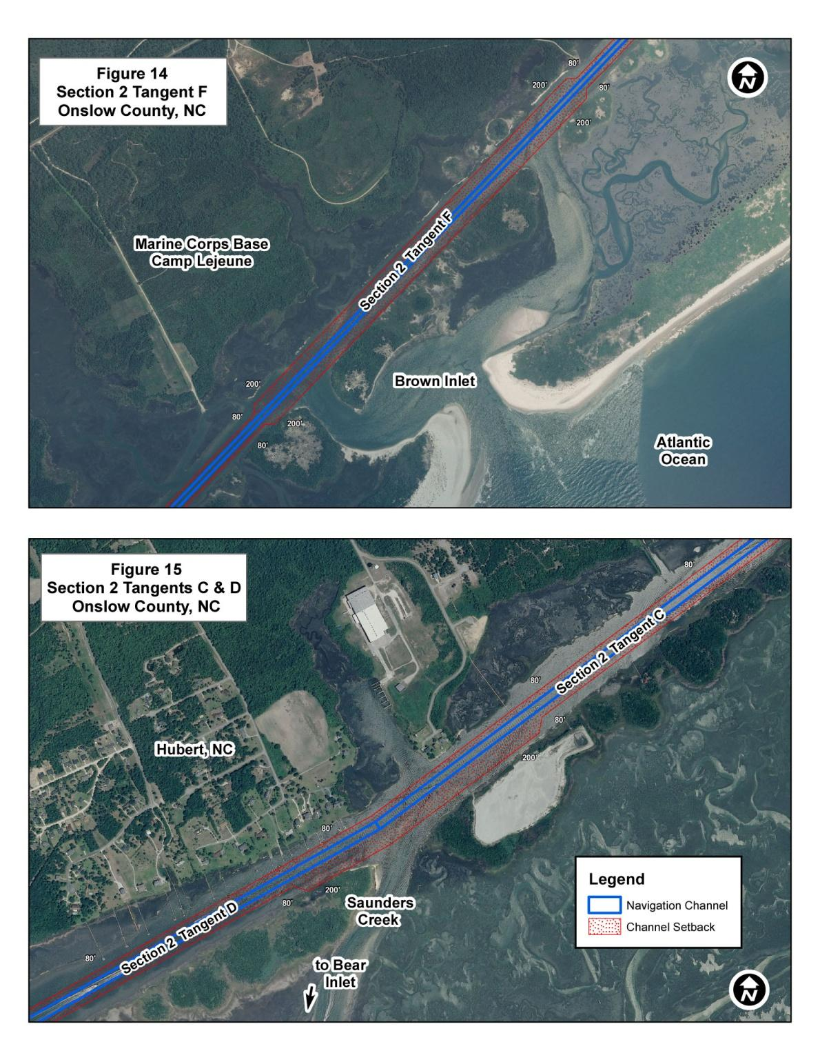
15 Setbacks at Bends in the AIWW Inlet Crossings

16 Inlet Crossings Setbacks vary by location Range from 100 to 200 feet in width, up to 7,800 feet in length Specific inlets: Shallotte Lockwoods Folly Carolina Beach Masonboro Mason s Topsail Creek New River Brown Inlet Saunders Creek Bogue

17

18 Channels Connecting with AIWW Revised with specific areas 100 foot setback, up to 750 feet in length Specific crossings: Lockwoods Folly Nixon Channel Butler Creek Green Channel

19 Channels Connecting with AIWW

20 Harborlines The setback policy will not apply to Federal projects that have established harbor and pierhead lines or where setbacks have been established by law. Harbor and pierhead lines have been established in the following areas Cape Fear River/Wilmington Harbor Morehead City Harbor and Waterfront Beaufort Harbor and Waterfront Neuse River/New Bern Pamlico River/Washington
21 Provisions Regarding New Structures, Existing Structures and their Development, Construction, Repair and Maintenance What if my Dock is currently within the Setback? Existing piers, docks, or other waterfront structures destroyed beyond repair by a storm, act of nature, or other sudden event, will only be replaced in accordance with the current Wilmington District setback policy, as well as any USACE Regulatory and North Carolina Division of Coastal Management permit requirements. The redevelopment or expansion of existing piers, docks, or other waterfront structures, (e.g., the conversion of commercial seafood docks to a residential marina), will be subject to current setback policy and any required regulatory permit action. The general maintenance and repair of existing piers, docks, or other waterfront structures located in the Federal channel setback may be authorized provided the work does not increase the footprint of the existing structure or results in additional encroachment into the setback. No new structures, and no reconstruction or redevelopment of existing structures, will be allowed within the authorized boundaries of any Federal channel.
22 Provisions Regarding New Structures, Existing Structures and their Development, Construction, Repair and Maintenance What if I am Building a New Dock? When submitting your permit application, you will need to identify where the setback line is and if you plan to cross it. If your construction plans cross the setback limit, then you will need to provide detailed documentation regarding your building materials, in order for us to ensure that you will not be using any hardened/permanent structures that will be anchored within the setback. It is our policy to only allow floating structures within the setback, on as case by case basis
 of any damaged structure, provided")
23 Coordination with CAMA? Structural Maintenance and Repair CAMA exempts the maintenance and repair (but not replacement) of any damaged structure, provided the repair is less than 50 percent of the value of the structure, as determined by a local building inspector.

24 Coordination with CAMA? Docks and Piers Docks and piers serve important functions along the coast, allowing access to water for recreational and commercial boating, swimming, diving, fishing and transportation. If poorly designed, however, docks and piers can obstruct navigation and the water circulation that sustains an estuary's natural systems. Piers must not extend more than one-fourth the width of a natural water body or man-made canal or basin (see Figure 4.9) Pier alignments along federally maintained channels must meet U.S. Army Corps of Engineers guidelines, available from the Corps' district office in Wilmington.
25 Opportunity for Public Participation But: Policy is not a rule subject to notice and comment process. Relatively short period of time elapsed between the prior Policy Memorandum #5 dated 24 August 2006 and the 21 July 2009 policy 15 March 2011 revisions offer clarify and specificity Areas around inlets and bends have been refined Impact remains a significant expansion of scope and regulation. Example: Holden Beach -- > numerous private structures affected Potentially significant effects on property values and tax values Depreciate lot values 25%? Contributory impact on structure? Effects on property values in fragile real estate market has repercussions for every sector in the coastal economy


26 Revised Holden Beach Previous Holden Beach

27 Moving Forward Wilmington District Setback Policy For all Federal Navigation Channels Where can the Setbacks be Viewed Graphically? All setbacks are graphically displayed on the Wilmington District s Navigation Internet Mapping Service (IMS) webpage.
 This is a presentation about the Commission s Rule 68D-24.006, Fort Lauderdale Boating Restricted Areas and Rule 68D-24.008, Broward County Boating Restricted Areas. These rules delineate boating safety
HOMEOWNERS INSURANCE UPDATE. Tyler Newman Governmental Affairs Director Business Alliance for a Sound Economy (BASE)
") HOMEOWNERS INSURANCE UPDATE Tyler Newman Governmental Affairs Director Business Alliance for a Sound Economy (BASE) BASE Business Alliance for a Sound Economy BASE covers government affairs for the coastal
HOMEOWNERS INSURANCE UPDATE Tyler Newman Governmental Affairs Director Business Alliance for a Sound Economy (BASE) BASE Business Alliance for a Sound Economy BASE covers government affairs for the coastal
South Atlantic Division Industry Day US Army Corps of Engineers BUILDING STRONG
 Col Steven Baker Commander USACE Wilmington District April 15, 2014 South Atlantic Division Industry Day US Army Corps of Engineers Wilmington District Boundaries Huntington District Roanoke Norfolk District
Impacts of Global Warming on North Carolina s Coastal Economy
 Impacts of Global Warming on North Carolina s Coastal Economy IMPACTS OF GLOBAL WARMING ON NORTH CAROLINA S COASTAL ECONOMY Key Findings Global warming is projected to have significant impacts on North
ORDINANCE NO.: 2008-01
 ORDINANCE NO.: 2008-01 AN ORDINANCE OF THE BOARD OF HERNANDO COUNTY COMMISSIONERS CREATING A SECfION OF THE HERNANDO COUNTY CODE RELATING TO THE MOORING OR DOCKING OF COMMERCIAL VESSELS AS DEFINED; PROVIDING
HARBOR INFRASTRUCTURE INVENTORIES Port Austin Harbor, Michigan
 HARBOR INFRASTRUCTURE INVENTORIES Port Austin Harbor, Michigan Harbor Location: Port Austin Harbor is located at the tip of the thumb of Michigan, about 80 miles northeast of Saginaw, MI Authority: Rivers
Jacksonville Port Authority: Fire and Rescue Marine Fire Station #40, Jacksonville, Florida
 Draft Tiered Site-Specific Environmental Assessment Jacksonville Port Authority: Fire and Rescue Marine Fire Station #40, Jacksonville, Florida Port Security Grant Program Project # 2008-GB-T8-K019 November
Alternative (Flexible) Mitigation Options Proposed Rule - Revised
 Mitigation Options Proposed Rule - Revised") Alternative (Flexible) Mitigation Options Proposed Rule - Revised NC Association of Environmental Professionals June 9, 2011 Background Purposes Update rules due to required changes from statutes Put all
Alternative (Flexible) Mitigation Options Proposed Rule - Revised NC Association of Environmental Professionals June 9, 2011 Background Purposes Update rules due to required changes from statutes Put all
Florida Fish and Wildlife Conservation Commission
 September 10, 2010 Florida Fish and Wildlife Conservation Commission Commissioners Rodney Barreto Chairman Miami Richard A. Corbett Vice Chairman Tampa Kathy Barco Jacksonville Ronald M. Bergeron Fort
Facing an Uncertain Future: Increasing Resilience at Marinas and Harbors. Recreational Boating Educational Conference December 11, 2014
 Facing an Uncertain Future: Increasing Resilience at Marinas and Harbors Recreational Boating Educational Conference December 11, 2014 Operators Face Change and Challenges Environmental Conditions Fluctuating
Gulf Intracoastal Waterway
 TEXAS DEPARTMENT OF TRANSPORTATION Gulf Intracoastal Waterway Photo by TexasGulfCoastOnline.com Gulf Intracoastal Waterway in Texas Figure 1 - Texas GIWW Executive Summary The Texas Department of Transportation
Aligning Natural and Built Infrastructure for
 Aligning Natural and Built Infrastructure for Houston Climate Resilience National Exercise Program (NEP) Houston Climate Change Preparedness & Resilience Workshop Edmond J. Russo, Jr., PhD, PE, D.CE, D.NE,
The Basics of Chapter 105 Waterways and Wetlands Permitting in PA
 The Basics of Chapter 105 Waterways and Wetlands Permitting in PA April 17, 2013 Goal To develop a basic understanding of PA Department of Environmental Protection (DEP) and US Army Corps of Engineers
Southwick Conservation Commission
 1.0 Jurisdiction 1.1 The (Town) annual permitting program is authorized pursuant to 310 CMR 9.07(3) and the DEP letter to the dated January 13, 2010. In the event of any discrepancy between these guidelines
North Carolina Aviation Industry
 2013 Report Card for Aviation Beaches & Inlets Bridges Dams Drinking Water Energy Rail Roads Public Schools Storm Water Wastewater Table of Contents Introduction 3 Grades Summary. 4 Aviation.. 5 Beaches
Ownership and Management of Port Administration
 Ownership and Management of Port Administration Yi-Chih Yang Associate Professor, Department of Shipping and Transportation Management, National Kaoshiung Marine University 1.Port management objectives
2015 SAME Small Business Conference and Industry Day 22 23 April 2015
 2015 SAME Conference and Industry Day 22 23 April 2015 Norfolk District 2015 Program Review Tracey J. Hughes, Chief, Programs US Army Corps of Engineers Agenda Missions and Vision Statements Areas of Responsibility
Goal 1 To protect the public health, safety and property from the harmful effects of natural disasters.
 Plan Framework for Coastal Management The purpose of this element is to provide for the protection of residents and property in within the coastal area of the host community, and to limit expenditures,
New York Sea Grant Strategic Plan
 New York Sea Grant Strategic Plan Introduction and Process This is the new strategic plan for New York Sea Grant (NYSG) for the years 2010-2013 as requested by the National Sea Grant Office. This plan
30 DAY PUBLIC NOTICE MAINTENANCE DREDGING OF THE FEDERAL NAVIGATION PROJECT IN COHASSET HARBOR COHASSET AND SCITUATE, MASSACHUSETTS
 .-ro:'j - I US Army Corps of Engineers r& New England District 696 Virginia Road Concord, MA 01742-2751 Public Notice In Reply Refer to: Mr. Craig Martin nae-pn-nav@usace.army.mil Programs/Project Management
U.S. Army Corps of Engineers
 Walla Walla District U.S. Army Corps of Engineers Hurricane Katrina Response Briefer: Joseph Saxon Today s Briefing U.S. Army Corps of Engineers Mission Events leading up to New Orleans flooding Corp s
BRUNSWICK COUNTY BOARD OF COMMISSIONERS. REGULAR MEETING AGENDA September 8, 2015 5: 45 PM
 DRAFT it BRUNSWICK COUNTY BOARD OF COMMISSIONERS REGULAR MEETING AGENDA September 8, 2015 5: 45 PM I. Call to Order II. Closed Session III. Invocation/ Pledge of Allegiance IV. Adjustments/ Approval of
U.S. Army Corps of Engineers, New York District Monitoring of a Hurricane Sandy Contract Needs Improvement
 Inspector General U.S. Department of Defense Report No. DODIG-2016-028 DECEMBER 3, 2015 U.S. Army Corps of Engineers, New York District Monitoring of a Hurricane Sandy Contract Needs Improvement INTEGRITY
boatinglifestyle A String of Pearls in OYSTER HARBOUR Cape Lookout Yacht Club Edenton Makes Waves Sound Adventures in New Blood in Historic New Bern
 Cover6_Mar05 3/9/05 1:24 AM Page 1 NC March 2005 boatinglifestyle The Lifestyle Magazine For Every North Carolina Powerboat Owner A String of Pearls in OYSTER HARBOUR Cape Lookout Yacht Club Makes Waves
April 17, 2015 SUMMARY OF SUBJECT MATTER
 April 17, 2015 SUMMARY OF SUBJECT MATTER TO: FROM: RE: Members, Subcommittee on Water Resources and Environment Staff, Subcommittee on Water Resources and Environment Hearing on A Review of the President
SITE DEVELOPMENT PLAN CHECKLIST. Project Name: Site Plan No.:
 SITE DEVELOPMENT PLAN CHECKLIST 5/12/05 Rev.3/14/06 Project Name: Site Plan No.: REVIEW CRITERIA Plans: A site development plan (signed and sealed) shall be on a 24 x 36 sheet at a scale that is no smaller
Oklahoma Governor s Water Conference
 Oklahoma Governor s Water Conference COL Michael Teague District Commander Tulsa District US Army Corps of Engineers 27 October 2010 US Army Corps of Engineers Tulsa District Over 600 people Arkansas River
Town of Surf City Community Development. General Permit Information
 Town of Surf City Community Development General Permit Information Phone: 910-328-4131 Fax: 910-328-4132 www.townofsurfcity.com Building Inspector: Steve Padgett steve@townofsurfcity.com Planning Director:
Waterfront Property: Do You Own it?
 Waterfront Property: Do You Own it? By Brian Madigan LL.B. If you are looking at waterfront property, you really want to know where your property ends and the lake begins. You definitely don t want a gap.
Section 401 Water Quality Certification
 Section 401 Water Quality Certification Department of Health Environmental Management Division Clean Water Branch Voice: (808) 586-4309 Fax: (808) 586-4352 http://www.hawaii.gov/health/environmental/water/cleanwater/index.html
MassDEP Natural Disaster Guidance for Coastal and Inland Wetland Resource Area Impacts: Hurricane or Tropical Storm Sandy
 MassDEP Natural Disaster Guidance for Coastal and Inland Wetland Resource Area Impacts: Hurricane or Tropical Storm Sandy Tropical Storm Sandy may cause severe flooding, erosion and other impacts to wetland
Cuyahoga County s Clean Ohio Revitalization Fund Round 5 Application Great Lakes Shipyard Expansion Project Attachment A1 Application Summary Document
 Cuyahoga County s Clean Ohio Revitalization Fund Round 5 Application Great Lakes Shipyard Expansion Project Attachment A1 Application Summary Document A1-1 ATTACHMENT A1 Great Lakes Shipyard Expansion
2. Market Area Background and Demographics Deliverable 1B
 2. Market Area Background and Demographics Deliverable 1B This section evaluates demographic and economic characteristics of the two principal sources of demand in the market area, the resident population
Veterans Memorial Bridge (Orange Avenue) PD&E Study
 PD&E Study") Veterans Memorial Bridge (Orange Avenue) PD&E Study From City Island Parkway to South Peninsula Drive FDOT FPID# 242172-128-01 Volusia County Project# P-5351-1 Project Limits End Project City Island Veterans
Veterans Memorial Bridge (Orange Avenue) PD&E Study From City Island Parkway to South Peninsula Drive FDOT FPID# 242172-128-01 Volusia County Project# P-5351-1 Project Limits End Project City Island Veterans
Executive Director s Budget Message
 Executive Director s Budget Message As Clatsop County continues to grow, it is presented with new opportunities. The Port will carefully coordinate its efforts with our community partners to develop public
The Boating Infrastructure Grant Program BIG. Additional guidance for developing a competitive BIG Tier II proposal.
 The Boating Infrastructure Grant Program BIG Additional guidance for developing a competitive BIG Tier II proposal (January 9, 2015) Suggested Template for Development of a Boating Infrastructure Grant/Tier
Short Title: Military Operations Protection Act of 2016. (Public) April 15, 2015
 April 15, 2015") GENERAL ASSEMBLY OF NORTH CAROLINA SESSION 01 H HOUSE BILL Second Edition Engrossed //1 Senate Agriculture/Environment/Natural Resources Committee Substitute Adopted /1/1 Fourth Edition Engrossed /0/1
GENERAL ASSEMBLY OF NORTH CAROLINA SESSION 01 H HOUSE BILL Second Edition Engrossed //1 Senate Agriculture/Environment/Natural Resources Committee Substitute Adopted /1/1 Fourth Edition Engrossed /0/1
New Orleans Hurricane Storm Damage Risk Reduction System Tour March 23 24, 2012
 New Orleans Hurricane Storm Damage Risk Reduction System Tour March 23 24, 2012 Host: Falcolm E. Hull, Vice President/Technical Expert, ARCADIS, U.S. Inc. Attending: Cherie Coffman, Coastal Projection
New or Prospective Member s Guide to Useful information about Raleigh Sail and Power Squadron
 New or Prospective Member s Guide to Useful information about Raleigh Sail and Power Squadron By P/C Ed Deyo, SN And Bunie Deyo, SN 1 New or Prospective Member Guide to Information about RSPS/USPS United
REAL-TIME AND NEAR REAL-TIME INTERNET MONITORING OF DREDGING OPERATIONS AND PRODUCTION
 REAL-TIME AND NEAR REAL-TIME INTERNET MONITORING OF DREDGING OPERATIONS AND PRODUCTION Marc P. Wakeman 1, Stephen D. Pace 2, and Aaron W. Douglas 3 ABSTRACT Developed in 1997, SAIC s Automated Disposal
(e) Harbor By-law - Article IX of the General By-laws.
 Harbor By-law - Article IX of the General By-laws.") TOWN OF COHASSET HARBOR DEPARTMENT COHASSET HARBOR REGULATIONS Section I Authority. Jurisdiction. and Purpose (a) This regulation is adopted pursuant to Section 10A of Chapter 91 of the Massachusetts General
TOWN OF COHASSET HARBOR DEPARTMENT COHASSET HARBOR REGULATIONS Section I Authority. Jurisdiction. and Purpose (a) This regulation is adopted pursuant to Section 10A of Chapter 91 of the Massachusetts General
1161.01 CONFORMITY WITH PLANS; DRAINAGE.
 CHAPTER 1161 Subdivision Requirements 1161.01 Conformity with plans; drainage 1161.07 Easements 1161.02 Trees 1161.08 Streets 1161.03 Subdivision name 1161.09 Blocks 1161.04 Street names 1161.10 Lots 1161.05
The St. Lucie River is 35 miles long and has two major forks, the North Fork and the South Fork. In the 1880s, the system was basically a freshwater
 The St. Lucie River is 35 miles long and has two major forks, the North Fork and the South Fork. In the 1880s, the system was basically a freshwater stream flowing into the Indian River Lagoon. An inlet
Piers, Wharves & Docks
 Piers, Wharves & Docks Exposures and Concerns By: Christopher L. Pesce May 10, 2011 Piers, Wharves & Docks Statistics Why underwriters love to write docks Estimated industry losses for 2010: $30,000,000
Summary of the Proposed 2017 Nationwide Permits 1
 Summary of the Proposed 2017 Nationwide Permits 1 Nationwide Permit NWP 1 Aids to Navigation 10 none PCN not no navigable waters of the U.S. none NWP 2 Structures in 10 none PCN not no navigable waters
Code of conduct Safe on-water conduct on the Brisbane River
 Code of conduct Safe on-water conduct on the Brisbane River Introduction The safe operation of passive craft on Queensland s waterways is a priority for state and local government authorities, commercial
COMPARABLE EVALUATION OF YACHT HAVEN BOATYARD
 COMPARABLE EVALUATION OF YACHT HAVEN BOATYARD AND 205 MAGEE AVENUE PROPOSED MARINA City of Stamford January 31, 2013 Bermello, Ajamil & Partners Architects, Inc. New York INDEX Section Title Page Section
Florida Lawmakers Amend Vessel Safety Regulations
 Anchoring Restrictions Florida Lawmakers Amend Vessel Safety Regulations In May 2005, the City of Miami Beach joined a number of other Florida municipalities in passing ordinances to regulate anchoring
RESTORATION AND ENHANCEMENT OF SOUTHERN CALIFORNIA LAGOONS
 RESTORATION AND ENHANCEMENT OF SOUTHERN CALIFORNIA LAGOONS by Hany Elwany, Ph.D. Scripps Institution of Oceanography Headwaters to Oceans Conference 25 October 2003 CE Ref #03-22 San Diego County Lagoons
PUBLIC OFFERING STATEMENT PALM SUITES OF ATLANTIC BEACH
 PUBLIC OFFERING STATEMENT PALM SUITES OF ATLANTIC BEACH 1. The name and principal address of the Declarant: Bogue View Suites, LLC 612 Blair Point Road Morehead City NC 28557 2. The name of the condominium:
This is a digital document from the collections of the Wyoming Water Resources Data System (WRDS) Library.
 Library.") This is a digital document from the collections of the Wyoming Water Resources Data System (WRDS) Library. For additional information about this document and the document conversion process, please contact
This is a digital document from the collections of the Wyoming Water Resources Data System (WRDS) Library. For additional information about this document and the document conversion process, please contact
Oakwood Beach Storm Damage Prevention Project NJDEP-Bureau of Coastal Engineering Glenn Golden, Project Manager U.S. Army Corps Civil Works Programs
 Oakwood Beach Storm Damage Prevention Project NJDEP- Glenn Golden, Project Manager U.S. Army Corps Civil Works Programs Branch Dwight Pakan, Project Manager, Philadelphia District The State of New Jersey
AYAK GUIDE ISLAND STATE PARKS. NEW YORK STATE George E. Pataki, Governor
 AYAK & C KAYAK AYAK & CANOE GUIDE TO LONG ISLAND STATE PARKS NEW YORK STATE George E. Pataki, Governor NEW YORK STATE OFFICE OF PARKS, RECREATION AND HISTORIC PRESERVATION Bernadette Castro, Commissioner
RESUME for Christopher G. Creed, P.E.
 Page One of Five Current Position Senior Engineer / Vice-President for Olsen Associates, Inc. a coastal engineering consulting firm in Jacksonville, Florida. Education Master of Civil Engineering, 1992.
MARYLAND DEPARTMENT OF THE ENVIRONMENT 1800 Washington Boulevard Baltimore MD 21230 410-537-3000 1-800-633-6101 www.mde.state.md.
 MARYLAND DEPARTMENT OF THE ENVIRONMENT 1800 Washington Boulevard Baltimore MD 21230 410-537-3000 1-800-633-6101 www.mde.state.md.us Martin O Malley Governor Robert M. Summers, Ph.D. Secretary Anthony G.
Shark River Municipal Marina 149 South Riverside Drive Neptune, NJ 07753 (732) 775-7400 Marina@NeptuneTownship.org
 775-7400 Marina@NeptuneTownship.org") Marina Rules and Regulations Boat/PWC owner(s) who hereby agree to lease a boat slip summer/winter storage space and or ramp access at the Shark River Municipal Marina are subject to the following Marina
Marina Rules and Regulations Boat/PWC owner(s) who hereby agree to lease a boat slip summer/winter storage space and or ramp access at the Shark River Municipal Marina are subject to the following Marina
Updates: LUR Rulemaking & FEMA Flood Mapping. Vince Mazzei, PE
 Updates: LUR Rulemaking & FEMA Flood Mapping Vince Mazzei, PE New Jersey Department of Environmental Protection Division of Land Use Regulation February 11, 2015 Today s topics: Brief overview of NJ s
Town of Beaufort, NC US Highway 70 Commercial Project
 Town of Beaufort, NC US Highway 70 Commercial Project Context The North Carolina Department of Transportation is proposing a new bridge and highway alignment that will relocate U.S. Highway 70 from its
The answers to some of the following questions are separated into two major categories:
 Following the recent flooding events for Front Range communities in Colorado, property owners, communities, and the National Flood Insurance Program are being presented with some new challenges in the
1. INTRODUCTION 5. THE PERMIT PROCESS
 1. INTRODUCTION Laws of the United States and the State of Iowa have assigned the US Army Corps of Engineers and the Iowa Department of Natural Resources with specific and different regulatory roles designed
GROWER ADVISORY Agriculture Regulations of the Wetlands Protection Act
 Cape Cod Cranberry Growers Association GROWER ADVISORY Agriculture Regulations of the Wetlands Protection Act Cranberry Bogs and the Agricultural Exemption The Massachusetts Wetlands Protection Act (WPA)
Bob Ivarson, PE, D.WRE. Sustainable Water Technologies Business Conference. June 17, 2014
 Bob Ivarson, PE, D.WRE Sustainable Water Technologies Business Conference June 17, 2014 In the old days we use to talk about conservation. Unsustainability, often is the collision of good intentions with
Remaining Wetland Acreage 1,500,000 915,960 584,040-39%
 NEW JERSEY Original Wetland Acreage Remaining Wetland Acreage Acreage Lost % Lost 1,500,000 915,960 584,040-39% New Jersey Wetlands: Nearly 99 percent of New Jersey s wetlands are palustrine or estuarine.
Floodplain 8-Step Process in accordance with Executive Order 11988: Floodplain Management. New Jersey Department of Environmental Protection
 Floodplain 8-Step Process in accordance with Executive Order 11988: Floodplain Management New Jersey Department of Environmental Protection U.S. Department of Housing and Urban Development Community Development
5.14 Floodplains and Drainage/Hydrology
 I-70 East Final EIS 5.14 Floodplains and Drainage/Hydrology 5.14 Floodplains and Drainage/Hydrology This section discusses floodplain and drainage/hydrology resources and explains why they are important
Eric D. (Ric) Hines, PE February 2012 US Army Corps of Engineers BUILDING STRONG
 Hines, PE February 2012 US Army Corps of Engineers BUILDING STRONG") U.S. Army Corps of Engineers Disaster Response Missions, Roles & Readiness Eric D. (Ric) Hines, PE February 2012 US Army Corps of Engineers Briefing Overview USACE Background Emergency Roles and Responsibilities
U.S. Army Corps of Engineers Disaster Response Missions, Roles & Readiness Eric D. (Ric) Hines, PE February 2012 US Army Corps of Engineers Briefing Overview USACE Background Emergency Roles and Responsibilities
Canals in Ocean City, Maryland. Terence J. McGean, PE City Engineer
 Canals in Ocean City, Maryland Terence J. McGean, PE City Engineer Background 64 canals in Ocean City Longest is approximately 4,400 lf Most created in the 60 s and early 70 s Bulkheads built in wetlands
United States Army Corps of Engineers, Civil Works
 United States Army Corps of Engineers, Civil Works Fiscal Year 2013 Federal Program Inventory May 2013 Table of Contents Introduction... 2 Program Inventory... 3 1. Navigation... 3 2. Flood Risk Management...
Marine Safety and Pollution Prevention Laws and Enforcement Authorities
 A rather large number of existing federal, state and local laws, regulations and ordinances affect the LA/LB Harbor area. The Committee does not have the resources to systematically review them, but has
Township of Georgian Bluffs POLICY USE OF UNOPENED ROAD ALLOWANCES
 Township of Georgian Bluffs POLICY USE OF UNOPENED ROAD ALLOWANCES 1.0 Background An unopened road allowance as defined by the Municipal Act is a public highway that has not been opened and assumed for
Sec. 2.2.15. General commercial district (C-4).
.") Sec. 2.2.15. General commercial district (C-4). 2.2.15.1. Purpose and intent. The general commercial district is intended to provide for those types of land uses that attract large segments of the population
Sec. 2.2.15. General commercial district (C-4). 2.2.15.1. Purpose and intent. The general commercial district is intended to provide for those types of land uses that attract large segments of the population
Laws and Regulations. Selected Federal Agencies. Illinois Clean Marina Guidebook. Selected Federal Agencies
 Laws and Regulations This chapter of laws, regulations, and permit information is by no means comprehensive. It is meant to provide the following: An introduction to the responsibilities of certain federal
Frequently-Asked Questions about Floodplains and Flood Insurance FLOOD INSURANCE
 Frequently-Asked Questions about Floodplains and Flood Insurance What is a floodplain? The floodplain is any area covered by water during normal water flows, and which could be inundated as a result of
GENERAL ASSEMBLY OF NORTH CAROLINA SESSION 2015 SESSION LAW 2015-232 SENATE BILL 446
 GENERAL ASSEMBLY OF NORTH CAROLINA SESSION 2015 SESSION LAW 2015-232 SENATE BILL 446 AN ACT TO PROVIDE FOR THE UNIFORM TREATMENT OF FRANCHISED DEALER LOANER VEHICLES; TO CLARIFY THAT AGENTS OR AGENCIES
Arkansas River Corridor Vision & Master Plan
 A r k a n s a s R I v e r C o r r I d o r P l a n Arkansas River Corridor Vision & Master Plan July 2005 Indian Nations Council of Governments A r k a n s a s R I v e r C o r r I d o r P l a n Partnership
Goals, Strategies, and Tasks
 Goals, Strategies, and Tasks Goals are the broadest expressions of a community's desires. Goals give direction to the plan as a whole. Goals are concerned with the long term, and often describe ideal situations
Home About DCM Contact DCM CAMA Counties Search DCM
 Home About DCM Contact DCM CAMA Counties Search DCM CAMA Handbook for Development in Coastal North Carolina How to Use This Guide This handbook is designed to help you understand what types of projects
Navy Inactive Ships Program
 EX-ARTHUR W. RADFORD (DD 968) Frequently Asked Questions STATUS OF THE SHIP AND PROJECT SUMMARY Q. What is the current status of ex-arthur W. RADFORD? A. Ex-ARTHUR W. RADFORD was decommissioned on March
U.S. Army Corps. of Engineers. A Learning Organization
 U.S. Army Corps A Learning Organization The Corps is committed to the protection of coral reefs and the effective mitigation of any impacts. The Corps believes that there is a need to improve the understanding
0.0 Curb Radii Guidelines Version 1.0.2
 Background In early 2014, Transportation Services initiated a review of the Division's design guidelines and standards to move our organization in a direction consistent with the transportation departments
APPENDIX 9-1 Project 1: City of Lompoc, Lompoc Valley Leak Detection and Repair Project
 APPENDIX 9 APPENDIX 9-1 Project 1: City of Lompoc, Lompoc Valley Leak Detection and Repair Project This project does not require an appendix to this attachment. APPENDIX 9-2 Project 2: City of Santa Maria,
Residential Driveway Installation Requirements. Table of Contents
 Residential Driveway Installation Requirements Table of Contents Residential Driveway Requirements Sidewalk Construction Specifications for Residential Properties Hold Harmless Agreement for Residential
Lockport Pool Chicago Sanitary & Ship Canal Illinois Waterway
 Presentation to the Inland Waterways Users Board Lockport Pool Chicago Sanitary & Ship Canal Illinois Waterway by Gary Loss, P.E. Rock Island District July 13, 2006 Chicago Sanitary and Ship Canal A
REAL PROPERTY COMMITTEE 5:30 p.m., Wednesday, January 8, 2014
 REAL PROPERTY COMMITTEE 5:30 p.m., Wednesday, The regular meeting of the Real Property Committee was held at 5:30 p.m., Wednesday, in the City Hall Conference Room, 1207 Palm Boulevard, Isle of Palms,
Program guidance that details the eligibility, criteria and application process. Ferry Boat Program. Ohio Department of Transportation
 Program guidance that details the eligibility, criteria and application process. Ferry Boat Program Ohio Department of Transportation TABLE OF CONTENTS Program Overview Program Administration.........2
Chairman s Decision No. (37) of 2013 concerning the licensing, hire, and usage of Personal Watercrafts (Jet Ski)
 of 2013 concerning the licensing, hire, and usage of Personal Watercrafts (Jet Ski)") Date: /7/2013 Chairman s Decision No. (37) of 2013 concerning the licensing, hire, and usage of Personal Watercrafts (Jet Ski) Chairman:- Having reviewed: - law No. (1) of 1974 concerning the reorganization
Date: /7/2013 Chairman s Decision No. (37) of 2013 concerning the licensing, hire, and usage of Personal Watercrafts (Jet Ski) Chairman:- Having reviewed: - law No. (1) of 1974 concerning the reorganization
How To Plan For A County Budget
 CHAPTER 10 CAPITAL IMPROVEMENTS ELEMENT The 1978 and 1985 Levy County Comprehensive Plans contained a statement of economic feasibility as a part of the Future Land Use Plan. This chapter updates that
DEPARTMENT OF THE ARMY
 REPLY TO ATTENTION OF: DEPARTMENT OF THE ARMY Little Rock District, Corps of Engineers Table Rock Lake Project Office 4600 State Highway 165, Suite A Branson, Missouri 65616-8980 (417) 334-4101 FAX: (417)
Lake Erie and the Ohio Charter Sport Fishing Industry 2010. Joe Lucente Assistant Professor and Extension Educator OSU / Ohio Sea Grant
 Lake Erie and the Ohio Charter Sport Fishing Industry 2010 Joe Lucente Assistant Professor and Extension Educator OSU / Ohio Sea Grant Why Survey? Provide business update Estimate economic impacts Look
Summary of the 2012 Nationwide Permits
 Summary of the 2012 Nationwide Permits Nationwide Permit NWP 1 Aids to Navigation 10 PCN not required NWP 2 Structures in 10 PCN not required Artificial Canals NWP 3 Maintenance 10/404 Does not authorize:
Emergency Streambank Restoration/Stabilization. Kentucky Division of Water Water Quality Certification May 2010 Educational Assistance
 Emergency Streambank Restoration/Stabilization Kentucky Division of Water Water Quality Certification May 2010 Educational Assistance Due to the severity of the recent rains and flooding occurrences, the
REHABILITATION PACKAGE 1-a
 1-a WINONA BRIDGE (BRIDGE 5900) REHABILITATION PACKAGE 1-a Rehab option 1-a is a rehabilitation package whereby all spans of the existing structure would be rehabilitated to the degree feasible and strengthened
SECTION 15 FLOODPLAIN MANAGEMENT
 SECTION 15 15.1 Purpose Certain areas of the City of Gardiner, Maine, are subject to periodic flooding, causing serious damages to properties within these areas. Relief is available in the form of flood
Fishing Support Service Employment
 Northeast Groundfish Interim Findings: Social Indicators Version: February 2014 Fishing Support Service Employment This indicator measures changes in employment in fishing support services, as a component
Planning Through Partnerships Alternative Transportation at Boston Harbor Islands National Park Area
 National Park Service U.S. Department of the Interior Alternative Transportation Program Washington, DC Planning Through Partnerships Alternative Transportation at Boston Harbor Islands National Park Area
FAIRFAX WATER OCCOQUAN RESERVOIR SHORELINE EASEMENT POLICY. February 17, 2011
 FAIRFAX WATER OCCOQUAN RESERVOIR SHORELINE EASEMENT POLICY February 17, 2011 I. Purpose The Occoquan Reservoir (the "Reservoir"), located in Fairfax and Prince William Counties, Virginia, was constructed
OKANOGAN COUNTY OFFICE OF PLANNING AND DEVELOPMENT FLOODPLAIN DEVELOPMENT PERMIT APPLICATION
 OKANOGAN COUNTY OFFICE OF PLANNING AND DEVELOPMENT FLOODPLAIN DEVELOPMENT PERMIT APPLICATION Okanogan County Code, OCC 15.08, Floodplain Management The State of Washington has authorized county governments
Failing Coastal Wood Infrastructure on the Great Lakes
 University of Wisconsin Sea Grant Institute Contact Gene Clark grclark@aqua.wisc.edu 715-392-3246 Failing Coastal Wood Infrastructure on the Great Lakes Gene Clark/UW Sea Grant Institute Introduction Many
World-Class. World-Wide.
 World-Class. World-Wide. Marinette Marine Corporation Bay Shipbuilding Company Ace Marine Complete Marine Solutions. Complete Marine Solutions. Complete Marine Solutions. Complete Marine Solutions. Marinette
USACE Civil Works Infrastructure Investment Trends: Glide-Path to Benign Neglect?
 USACE Civil Works Infrastructure Investment Trends: Glide-Path to Benign Neglect? National Waterways Conference Legislative Summit Steven L. Stockton, P.E. Director of Civil Works, U.S. Army Corps of Engineers