GIS in Meteorology and Climate Science
|
|
|
- Maximilian Hubbard
- 7 years ago
- Views:
Transcription


1 GIS in Meteorology and Climate Science Olga Wilhelmi and Jennifer Boehnert NCAR / Research Applications Program African Weather and Climate: Unique Challenges and Application of New Knowledge 25 July 5 August 2011, NCAR, Boulder, Colorado
2 Outline NCAR GIS program Introduction to GIS GIS in meteorology and climatology Data interoperability Science applications
3 NCAR Science Climate Earth's past climate, greenhouse effect and global warming, Earth's future, El Niño & La Niña, drought and wildfires. Meteorology/Weather Short-term forecasts, weather forecasting and predictability, weather's effect on climate, training meteorologists, severe storms, physical processes. Societal Impacts, vulnerability and adaptation Effects of weather & climate on society, human health, urban water management, national security, risk perceptions, integrated assessments, economics Pollution & Air Chemistry Air pollution, chemistry of our atmosphere, tracking plumes, ozone. The Whole Earth System Oceans effects on climate and weather, the effects of land use on climate and weather, cryosphere/ice, the water cycle. Sun & Space Weather Solar furnace, suns effect on weather and climate, the solar

4 web: Interdisciplinary effort to foster collaborative science, spatial data interoperability, and knowledge sharing with GIS. Goals: Support the use of GIS as both an analysis, and an infrastructure tool at NCAR; Conduct research integrating atmospheric, the Earth system and social sciences through spatial analysis and interoperability of georeferenced information; Improve usable science through data sharing; and Address issues of spatial data management, interoperability, and geoinformatics within the geosciences.

5 NCAR GIS Program Partnerships OGC Esri Atmo/GIS-Community Standards Unidata (Ben Domenico) netcdf Analysis tools OGC-NCAR MOU Development of OGC technology within the atmospheric sciences and to extend OpenGIS specifications to include the geospatial processing needs of the atmospheric community Outcome: CF-netCDF is an OGC standard Esri NCAR MOU Advancing GIS technical methods and technologies; Exploring the development of atmospheric information and models within GIS domains Outcome: netcdf CF in ArcGIS Atmo-GIS community workshops

6 Program elements and current priority areas GIScience Research enabled by GIS Data distribution Building community Education, Training & User Support Coupling natural and social sciences through integration of quantitative and qualitative data Improving spatial accuracy and usability of atmospheric models for terrestrial and societal applications Building capacity through GIS-focused education, usable GIS lab, community workshops and enabling interdisciplinary research

7 Geographic Information Systems GIS is a science and a technology that includes elements of Computer visualization Database management Query, spatial analysis and modeling Web services Powerful information management tool


 allows")
8 GIS Overlays Geographical referencing allows for mapping spatial and non-spatial data together to reach a common interpretation GIS overlay (data integration) allows to create or identify spatial relationships


9 A broader perspective of GIS Theories Applications Thematic domains COMMUNITY Data, Information, and Communication Systems Computation and Algorithms Communication and Decision Support Source: May Yuan (U. Oklahoma) Society


10 Diverse atmospheric data

, qualitative (e.g.")


11 Data challenges Spatially and/or temporally structured quantitative (e.g., surveys), qualitative (e.g., interviews, images), often context-specific pieces of information Social Sciences Data Integration/ Spatial Analysis GIS Earth Sciences


12 NetCDF in ArcGIS Atmospheric community ESRI collaboration Since 2006 release of ArcGIS 9.2 NetCDF CF format can be read in GIS


 and accumulated")

13 Mesoscale Weather Models (WRF) Interactive web mapping application which integrates WRF forecast with socio-economic and infrastructure data Dynamically adds netcdf WRF Hurricane model through ArcGIS Server Symbolized based on hurricane wind scale (Saffir-Simpson Wind Scale) and accumulated rain User-defined query about possible impacts (population density, schools, critical infrastructure) From J. Boehnert (NCAR)
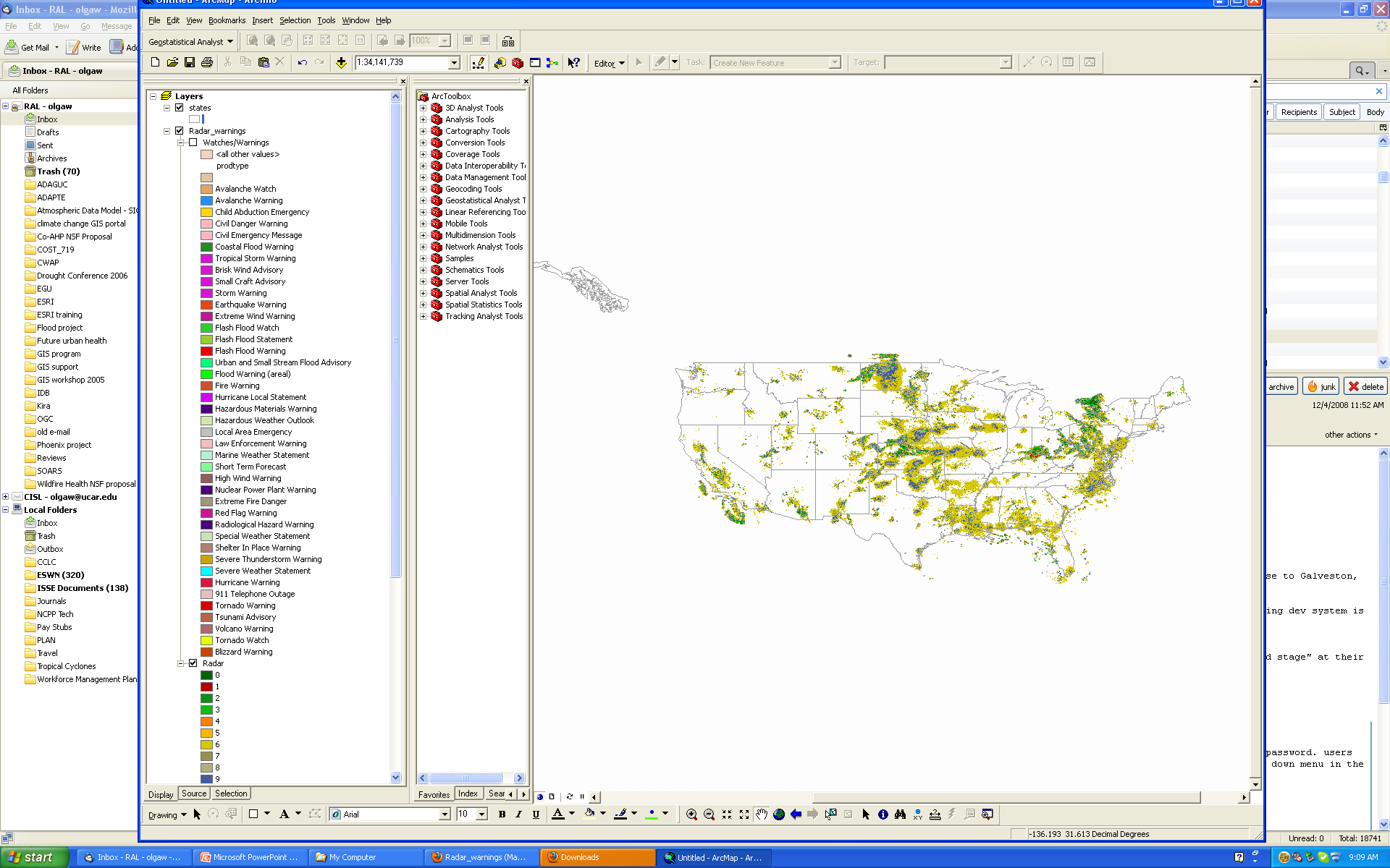
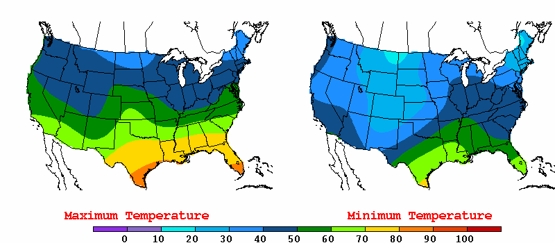
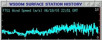
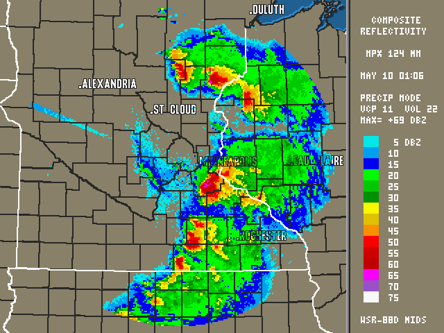
14 Operational meteorology Radar Warnings


15 Monitoring Rainfall in the IRI Map Room Source: IRI, P. Cecatto


16 Rainfall estimation Source: IRI, P. Cecatto

17 Global Climate Models (CCSM) Distributing outputs from NCAR Community Climate System Model (CCSM), generated for IPCC AR4, in a GIS format Monthly averages Global CCSM runs Downscaled USA projections Dynamic converter from netcdf to shapefile ~3700 users from 133 countries; ~49K downloads
 Near-term (2020-2039) Mid-century (2040-2059) End of 21 st Century (2080-2099)» Special subset")

18 Climate products Temperature and Precipitation Annual and seasonal averages Anomalies from present climate ( ) Near-term ( ) Mid-century ( ) End of 21 st Century ( )» Special subset ( ) Pilot for distributing these products as OGC Web Mapping Service and Web Coverage Service Challenges due to multidimensional nature of data Data description metadata

19 Future scenarios and uncertainty
 Trend (What has changed...) Pattern (What is the pattern...) Modeling and Prediction (What if...) Why?")
20 Spatial analysis and GIS applications Visualization of information Spatial analysis Location (Where is it...) Condition (What is it...) Trend (What has changed...) Pattern (What is the pattern...) Modeling and Prediction (What if...) Why? (linking spatial and non-spatial data) Data sharing

, but also include Spain, Argentina, Nepal and Iran Majority of cities")
21 Rate of change: extreme heat events and urban population Majority of cities with greatest rate of change are located in mid- and high latitude countries (e.g., US, Russia, Norway, Canada, Ireland, Chile), but also include Spain, Argentina, Nepal and Iran Majority of cities with greatest rate of change in urban population are in low-latitude countries (e.g., Iraq, Egypt, Oman, Brazil, Venezuela, Libya, Rwanda, Papua New Guinea, Yemen), but also include Iceland.

22 Climate indices Source: CIESIN, A. de Sherbinin. The Biophysical and Geographical Correlates of Child Malnutrition in Africa (2009)

23 Integration of atmospheric and social data Wilhelmi and Hayden (ERL, 2010)


24 Role of scale Impacts, risk and vulnerability are spatially differentiated National and regional assessments can mask communities living in marginal conditions Hazard mitigation and climate change adaptation measures have to be adjusted for local ecology and appropriate level of decision making O Brien et al Local-level assessment ensures more targeted intervention, response, adaptation. Borden et al Top down/bottom up approach is essential


25 System for Integrated Modeling of Metropolitan Extreme heat Risk (SIMMER) RAL CGD IMAGe NASA ROSES (09-IDS09-34) FY10-13
26 SIMMER Tools and Data Local Scale Models Weather Research and Forecasting Model (WRF) Noah Land Surface Model (Noah LSM) w/ Urban Canopy Model (UCM) Regional Scale Models Community Earth System Model (CESM/CCSM; atmosphere, ocean, land, sea ice, ) Urban Community Land Model (CLMU) Urban Datasets Local land cover / urban heat island (Houston) Regional (U.S., Southern Canada) (based on Landscan USA or similar) NASA Satellite Data Demographic Datasets US Census Household Survey
27 Remaining challenges and research directions Availability of spatial data at the local scale Input into atmospheric models Societal data (proxy) Multidimensional GIS Data interoperability across disciplines (data, semantics, scales) Representation of uncertainty Integration of physical and social sciences requires further research on methods and tools for working with multidimensional data, across spatial and temporal scales, and including both quantitative and qualitative information.
28 Summary GIS is critical to integrating data sources from different disciplines. Significant progress has been made in linking GIS and meteorology but few challenges remain. Growing interest among practitioners in GIS- compatible atmospheric data Growing recognition among researchers and organizations that GIS is appropriate tool for research, climate change adaptation and science communication. Ongoing research in GIScience and developments in geospatial technology may further increase the use of GIS in meteorology and climate science.
29 Thank you!
GIS Initiative: Developing an atmospheric data model for GIS. Olga Wilhelmi (ESIG), Jennifer Boehnert (RAP/ESIG) and Terri Betancourt (RAP)
, Jennifer Boehnert (RAP/ESIG) and Terri Betancourt (RAP)") GIS Initiative: Developing an atmospheric data model for GIS Olga Wilhelmi (ESIG), Jennifer Boehnert (RAP/ESIG) and Terri Betancourt (RAP) Unidata seminar August 30, 2004 Presentation Outline Overview
GIS Initiative: Developing an atmospheric data model for GIS Olga Wilhelmi (ESIG), Jennifer Boehnert (RAP/ESIG) and Terri Betancourt (RAP) Unidata seminar August 30, 2004 Presentation Outline Overview
Simulating the urban heat island of Greater Houston, Texas
 09 July 2013 Simulating the urban heat island of Greater Houston, Texas Andrew Monaghan, Michael Barlage, Leiqiu Hu, Nathan Brunsell, Johannes Feddema, Olga Wilhelmi Steve Sain 1 The System for Integrated
PART 1. Representations of atmospheric phenomena
 PART 1 Representations of atmospheric phenomena Atmospheric data meet all of the criteria for big data : they are large (high volume), generated or captured frequently (high velocity), and represent a
Climate Change: A Local Focus on a Global Issue Newfoundland and Labrador Curriculum Links 2010-2011
 Climate Change: A Local Focus on a Global Issue Newfoundland and Labrador Curriculum Links 2010-2011 HEALTH Kindergarten: Grade 1: Grade 2: Know that litter can spoil the environment. Grade 3: Grade 4:
GOSIC NEXRAD NIDIS NOMADS
 NOAA National Climatic Data Center GOSIC NEXRAD NIDIS NOMADS Christina Lief NOAA/NESDIS/NCDC GOSIC Program Manager NOAA/NESDIS/NCDC Asheville, NC 28801 GEOSS AIP Phase 2 Workshop September 25-26, 2008
Driving Earth Systems Collaboration across the Pacific
 Driving Earth Systems Collaboration across the Pacific Tim F. Pugh Centre for Australian Weather and Climate Research Australian Bureau of Meteorology What s our business? Earth System Science Study of
13.2 THE INTEGRATED DATA VIEWER A WEB-ENABLED APPLICATION FOR SCIENTIFIC ANALYSIS AND VISUALIZATION
 13.2 THE INTEGRATED DATA VIEWER A WEB-ENABLED APPLICATION FOR SCIENTIFIC ANALYSIS AND VISUALIZATION Don Murray*, Jeff McWhirter, Stuart Wier, Steve Emmerson Unidata Program Center, Boulder, Colorado 1.
CIESIN Columbia University
 Conference on Climate Change and Official Statistics Oslo, Norway, 14-16 April 2008 The Role of Spatial Data Infrastructure in Integrating Climate Change Information with a Focus on Monitoring Observed
Development of an Integrated Data Product for Hawaii Climate
 Development of an Integrated Data Product for Hawaii Climate Jan Hafner, Shang-Ping Xie (PI)(IPRC/SOEST U. of Hawaii) Yi-Leng Chen (Co-I) (Meteorology Dept. Univ. of Hawaii) contribution Georgette Holmes
Preliminary advances in Climate Risk Management in China Meteorological Administration
 Preliminary advances in Climate Risk Management in China Meteorological Administration Gao Ge Guayaquil,Ecuador, Oct.2011 Contents China Framework of Climate Service Experience in Climate/disaster risk
The IPCC Special Report on Managing the Risks of Extreme Events and Disasters to Advance Climate Change Adaptation
 The IPCC Special Report on Managing the Risks of Extreme Events and Disasters to Advance Climate Change Adaptation A changing climate leads to changes in extreme weather and climate events 2 How do changes
Scientific Data Management and Dissemination
 Federal GIS Conference February 9 10, 2015 Washington, DC Scientific Data Management and Dissemination John Fry Solution Engineer, Esri jfry@esri.com Agenda Background of Scientific Data Management through
Baudouin Raoult, Iryna Rozum, Dick Dee
 ECMWF contribution to the EU funded CHARME Project: A Significant Event Viewer tool Matthew Manoussakis Baudouin Raoult, Iryna Rozum, Dick Dee 5th Workshop on the use of GIS/OGC standards in meteorology
II. Related Activities
 (1) Global Cloud Resolving Model Simulations toward Numerical Weather Forecasting in the Tropics (FY2005-2010) (2) Scale Interaction and Large-Scale Variation of the Ocean Circulation (FY2006-2011) (3)
Armenian State Hydrometeorological and Monitoring Service
 Armenian State Hydrometeorological and Monitoring Service Offenbach 1 Armenia: IN BRIEF Armenia is located in Southern Caucasus region, bordering with Iran, Azerbaijan, Georgia and Turkey. The total territory
sample The IPCC Special Report on Managing the Risks of Extreme Events and Disasters to Advance Climate Change Adaptation
 sample The IPCC Special Report on Managing the Risks of Extreme Events and Disasters to Advance Climate Change Adaptation A changing climate leads to changes in extreme weather and climate events 2 Impacts
5 day Training on Climate Change and Adaptation
 Training Programme 5 day Training on and Adaptation Developed by: Bangladesh Centre for Advanced Studies (BCAS) [A comprehensive training module along with guideline for trainers aiming to enhance capacity
Jessica Blunden, Ph.D., Scientist, ERT Inc., Climate Monitoring Branch, NOAA s National Climatic Data Center
 Kathryn Sullivan, Ph.D, Acting Under Secretary of Commerce for Oceans and Atmosphere and NOAA Administrator Thomas R. Karl, L.H.D., Director,, and Chair of the Subcommittee on Global Change Research Jessica
Geospatial Software Solutions for the Environment and Natural Resources
 Geospatial Software Solutions for the Environment and Natural Resources Manage and Preserve the Environment and its Natural Resources Our environment and the natural resources it provides play a growing
climate science A SHORT GUIDE TO This is a short summary of a detailed discussion of climate change science.
 A SHORT GUIDE TO climate science This is a short summary of a detailed discussion of climate change science. For more information and to view the full report, visit royalsociety.org/policy/climate-change
THE STRATEGIC PLAN OF THE HYDROMETEOROLOGICAL PREDICTION CENTER
 THE STRATEGIC PLAN OF THE HYDROMETEOROLOGICAL PREDICTION CENTER FISCAL YEARS 2012 2016 INTRODUCTION Over the next ten years, the National Weather Service (NWS) of the National Oceanic and Atmospheric Administration
A Project to Create Bias-Corrected Marine Climate Observations from ICOADS
 A Project to Create Bias-Corrected Marine Climate Observations from ICOADS Shawn R. Smith 1, Mark A. Bourassa 1, Scott Woodruff 2, Steve Worley 3, Elizabeth Kent 4, Simon Josey 4, Nick Rayner 5, and Richard
Analysis of Climatic and Environmental Changes Using CLEARS Web-GIS Information-Computational System: Siberia Case Study
 Analysis of Climatic and Environmental Changes Using CLEARS Web-GIS Information-Computational System: Siberia Case Study A G Titov 1,2, E P Gordov 1,2, I G Okladnikov 1,2, T M Shulgina 1 1 Institute of
Atmospheric Dynamics of Venus and Earth. Institute of Geophysics and Planetary Physics UCLA 2 Lawrence Livermore National Laboratory
 Atmospheric Dynamics of Venus and Earth G. Schubert 1 and C. Covey 2 1 Department of Earth and Space Sciences Institute of Geophysics and Planetary Physics UCLA 2 Lawrence Livermore National Laboratory
CLOUD BASED N-DIMENSIONAL WEATHER FORECAST VISUALIZATION TOOL WITH IMAGE ANALYSIS CAPABILITIES
 CLOUD BASED N-DIMENSIONAL WEATHER FORECAST VISUALIZATION TOOL WITH IMAGE ANALYSIS CAPABILITIES M. Laka-Iñurrategi a, I. Alberdi a, K. Alonso b, M. Quartulli a a Vicomteh-IK4, Mikeletegi pasealekua 57,
Design and Deployment of Specialized Visualizations for Weather-Sensitive Electric Distribution Operations
 Fourth Symposium on Policy and Socio-Economic Research 4.1 Design and Deployment of Specialized Visualizations for Weather-Sensitive Electric Distribution Operations Lloyd A. Treinish IBM, Yorktown Heights,
Steve Ansari *, Stephen Del Greco, Brian Nelson, and Helen Frederick NOAA National Climatic Data Center, Asheville, North Carolina 2.
 11.4 THE SEVERE WEATHER DATA INVENTORY (SWDI): SPATIAL QUERY TOOLS, WEB SERVICES AND DATA PORTALS AT NOAA S NATIONAL CLIMATIC DATA CENTER (NCDC) Steve Ansari *, Stephen Del Greco, Brian Nelson, and Helen
Tim Killeen President Designate, University of Illinois April 29, 2015
 Tim Killeen President Designate, University of Illinois April 29, 2015 Introduction Compelling requirements National and International Efforts Obstacles and Needs Professor of Atmospheric, Oceanic, and
New challenges of water resources management: Title the future role of CHy
 New challenges of water resources management: Title the future role of CHy by Bruce Stewart* Karl Hofius in his article in this issue of the Bulletin entitled Evolving role of WMO in hydrology and water
Data Products via TRMM Online Visualization and Analysis System
 Accessing Global Precipitation Data Products via TRMM Online Visualization and Analysis System (TOVAS) Zhong Liu Center for Spatial Information Science and Systems (CSISS), George Mason University and
Norwegian Satellite Earth Observation Database for Marine and Polar Research http://normap.nersc.no USE CASES
 Norwegian Satellite Earth Observation Database for Marine and Polar Research http://normap.nersc.no USE CASES The NORMAP Project team has prepared this document to present functionality of the NORMAP portal.
How To Predict Climate Change
 A changing climate leads to changes in extreme weather and climate events the focus of Chapter 3 Presented by: David R. Easterling Chapter 3:Changes in Climate Extremes & their Impacts on the Natural Physical
Basic Climatological Station Metadata Current status. Metadata compiled: 30 JAN 2008. Synoptic Network, Reference Climate Stations
 Station: CAPE OTWAY LIGHTHOUSE Bureau of Meteorology station number: Bureau of Meteorology district name: West Coast State: VIC World Meteorological Organization number: Identification: YCTY Basic Climatological
DEPARTMENT OF GEOGRAPHY AND ENVIRONMENTAL STUDIES
 DEPARTMENT OF GEOGRAPHY AND ENVIRONMENTAL STUDIES STAFF POST STAFF MEMBER QUALIFICATION Professor and HOD Associate Professor Senior Lecturers Lecturers Vacant Vacant Vacant H Chikoore A T Mthembu N P
Temporal variation in snow cover over sea ice in Antarctica using AMSR-E data product
 Temporal variation in snow cover over sea ice in Antarctica using AMSR-E data product Michael J. Lewis Ph.D. Student, Department of Earth and Environmental Science University of Texas at San Antonio ABSTRACT
Satellite'&'NASA'Data'Intro'
 Satellite'&'NASA'Data'Intro' Research'vs.'Opera8ons' NASA':'Research'satellites' ' ' NOAA/DoD:'Opera8onal'Satellites' NOAA'Polar'Program:'NOAA>16,17,18,19,NPP' Geosta8onary:'GOES>east,'GOES>West' DMSP'series:'SSM/I,'SSMIS'
How To Help The Environment
 CIIFEN Activities 2012 Rodney Martínez Güingla r.martinez@ciifen.org Workshop on Climate Change in Mediterranean and Caribbean Seas: Guayaquil, Ecuador, 08-11 May 2011 MISSION To promote, coordinate and
DIABLO VALLEY COLLEGE CATALOG 2016-2017
 Geography GEOGRAPHY GEOG Tish Young, Dean Physical Sciences and Engineering Division Physical Sciences Building, Room 263 Possible career opportunities Geography is an interdisciplinary study focusing
NCDC Strategic Vision
 NOAA s National Climatic Data Center World s Largest Archive of Climate and Weather Data Presented to: Coastal Environmental Disasters Data Management Workshop September 16, 2014 Stephen Del Greco Deputy
Geosciences - Programme subject in programme for Specialization in General Studies
 Geosciences - Programme subject in programme for Specialization in General Studies Dette er en oversettelse av den fastsatte læreplanteksten. Læreplanen er fastsatt på Bokmål Laid down as a regulation
Dimensions of climate and health risks and opportunities. Rural and agriculture
 Dimensions of climate and health risks and opportunities Rural and agriculture 19 th May 2016 Helsinki Madeleine C. Thomson International Research Institute for Climate and Society, Department of Environmental
Global Earth Observation Integrated Data Environment (GEO-IDE) Presentation to the Data Archiving and Access Requirements Working Group (DAARWG)
 Presentation to the Data Archiving and Access Requirements Working Group (DAARWG)") Global Earth Observation Integrated Data Environment (GEO-IDE) Presentation to the Data Archiving and Access Requirements Working Group (DAARWG) Ken McDonald Data Management Integration Architect National
Global Earth Observation Integrated Data Environment (GEO-IDE) Presentation to the Data Archiving and Access Requirements Working Group (DAARWG) Ken McDonald Data Management Integration Architect National
Malcolm L. Spaulding Professor Emeritus, Ocean Engineering University of Rhode Island Narragansett, RI 02881
 Malcolm L. Spaulding Professor Emeritus, Ocean Engineering University of Rhode Island Narragansett, RI 02881 USACE Coastal and Hydraulics Laboratory(CHL) Data Infrastructure Workshop January 23, 2014 Overview
visualization tool for interpretation of empirical results from climate model: Does it add value to UbuntuNet Connect Kigali, Rwanda 2013
 Development of a climate data visualization tool for interpretation of empirical results from climate model: Does it add value to different stakeholders? UbuntuNet Connect Kigali, Rwanda 2013 Co-Authors
Description and Testing of the Geo Data Portal: A Data Integration Framework and Web Processing Services for Environmental Science Collaboration
 Description and Testing of the Geo Data Portal: A Data Integration Framework and Web Processing Services for Environmental Science Collaboration Open-File Report 2011 1157 U.S. Department of the Interior
NetCDF and HDF Data in ArcGIS
 2013 Esri International User Conference July 8 12, 2013 San Diego, California Technical Workshop NetCDF and HDF Data in ArcGIS Nawajish Noman Kevin Butler Esri UC2013. Technical Workshop. Outline NetCDF
TOPIC 4 Disaster Risks, Mitigation, Warning Systems & Socio-Economic Impacts. Jim Davidson
 TOPIC 4 Disaster Risks, Mitigation, Warning Systems & Socio-Economic Impacts Jim Davidson Richard Murnane Bill Read Lixion Avila - ST Chan Linda Anderson-Berry David King - Ryan Crompton IWTC-VII November
California Standards Grades 9 12 Boardworks 2009 Science Contents Standards Mapping
 California Standards Grades 912 Boardworks 2009 Science Contents Standards Mapping Earth Sciences Earth s Place in the Universe 1. Astronomy and planetary exploration reveal the solar system s structure,
Fire Weather Index: from high resolution climatology to Climate Change impact study
 Fire Weather Index: from high resolution climatology to Climate Change impact study International Conference on current knowledge of Climate Change Impacts on Agriculture and Forestry in Europe COST-WMO
Introduction to Geographical. Information Systems. Government 1008. Lecture 1: Introduction to Course and Content Sumeeta Srinivasan
 Government 1008 Introduction to Geographical Information Systems Lecture 1: Introduction to Course and Content Sumeeta Srinivasan Reference: Longley, Goodchild, et al. Geographic Information Systems and
The Arctic Observing Network and its Data Management Challenges Florence Fetterer (NSIDC/CIRES/CU), James A. Moore (NCAR/EOL), and the CADIS team
, James A. Moore (NCAR/EOL), and the CADIS team") The Arctic Observing Network and its Data Management Challenges Florence Fetterer (NSIDC/CIRES/CU), James A. Moore (NCAR/EOL), and the CADIS team Photo courtesy Andrew Mahoney NSF Vision What is AON? a
The Arctic Observing Network and its Data Management Challenges Florence Fetterer (NSIDC/CIRES/CU), James A. Moore (NCAR/EOL), and the CADIS team Photo courtesy Andrew Mahoney NSF Vision What is AON? a
Nevada NSF EPSCoR Track 1 Data Management Plan
 Nevada NSF EPSCoR Track 1 Data Management Plan August 1, 2011 INTRODUCTION Our data management plan is driven by the overall project goals and aims to ensure that the following are achieved: Assure that
EUROPEAN COMMISSION. Better Regulation "Toolbox" This Toolbox complements the Better Regulation Guideline presented in in SWD(2015) 111
 111") EUROPEAN COMMISSION Better Regulation "Toolbox" This Toolbox complements the Better Regulation Guideline presented in in SWD(2015) 111 It is presented here in the form of a single document and structured
EUROPEAN COMMISSION Better Regulation "Toolbox" This Toolbox complements the Better Regulation Guideline presented in in SWD(2015) 111 It is presented here in the form of a single document and structured
Integrated Risk Management System Components in the GEO Architecture Implementation Pilot Phase 2 (AIP-2)
") Meraka Institute ICT for Earth Observation PO Box 395 Pretoria 0001, Gauteng, South Africa Telephone: +27 12 841 3028 Facsimile: +27 12 841 4720 University of KwaZulu- Natal School of Computer Science
Meraka Institute ICT for Earth Observation PO Box 395 Pretoria 0001, Gauteng, South Africa Telephone: +27 12 841 3028 Facsimile: +27 12 841 4720 University of KwaZulu- Natal School of Computer Science
Fundamentals of Climate Change (PCC 587): Water Vapor
: Water Vapor") Fundamentals of Climate Change (PCC 587): Water Vapor DARGAN M. W. FRIERSON UNIVERSITY OF WASHINGTON, DEPARTMENT OF ATMOSPHERIC SCIENCES DAY 2: 9/30/13 Water Water is a remarkable molecule Water vapor
Fundamentals of Climate Change (PCC 587): Water Vapor DARGAN M. W. FRIERSON UNIVERSITY OF WASHINGTON, DEPARTMENT OF ATMOSPHERIC SCIENCES DAY 2: 9/30/13 Water Water is a remarkable molecule Water vapor
Titelmasterformat durch Klicken. bearbeiten
 Evaluation of a Fully Coupled Atmospheric Hydrological Modeling System for the Sissili Watershed in the West African Sudanian Savannah Titelmasterformat durch Klicken June, 11, 2014 1 st European Fully
Climate, water and renewable energy in the Nordic countries
 102 Regional Hydrological Impacts of Climatic Change Hydroclimatic Variability (Proceedings of symposium S6 held during the Seventh IAHS Scientific Assembly at Foz do Iguaçu, Brazil, April 2005). IAHS
The Next Generation Science Standards (NGSS) Correlation to. EarthComm, Second Edition. Project-Based Space and Earth System Science
 Correlation to. EarthComm, Second Edition. Project-Based Space and Earth System Science") The Next Generation Science Standards (NGSS) Achieve, Inc. on behalf of the twenty-six states and partners that collaborated on the NGSS Copyright 2013 Achieve, Inc. All rights reserved. Correlation to,
The Next Generation Science Standards (NGSS) Achieve, Inc. on behalf of the twenty-six states and partners that collaborated on the NGSS Copyright 2013 Achieve, Inc. All rights reserved. Correlation to,
Development of Method for LST (Land Surface Temperature) Detection Using Big Data of Landsat TM Images and AWS
 Detection Using Big Data of Landsat TM Images and AWS") Development of Method for LST (Land Surface Temperature) Detection Using Big Data of Landsat TM Images and AWS Myung-Hee Jo¹, Sung Jae Kim², Jin-Ho Lee 3 ¹ Department of Aeronautical Satellite System Engineering,
Development of Method for LST (Land Surface Temperature) Detection Using Big Data of Landsat TM Images and AWS Myung-Hee Jo¹, Sung Jae Kim², Jin-Ho Lee 3 ¹ Department of Aeronautical Satellite System Engineering,
Scholar: Elaina R. Barta. NOAA Mission Goal: Climate Adaptation and Mitigation
 Development of Data Visualization Tools in Support of Quality Control of Temperature Variability in the Equatorial Pacific Observed by the Tropical Atmosphere Ocean Data Buoy Array Abstract Scholar: Elaina
Earth Sciences -- Grades 9, 10, 11, and 12. California State Science Content Standards. Mobile Climate Science Labs
 Earth Sciences -- Grades 9, 10, 11, and 12 California State Science Content Standards Covered in: Hands-on science labs, demonstrations, & activities. Investigation and Experimentation. Lesson Plans. Presented
Critical Need to Rebuild Atlantic City and Protect Vulnerable Environmental Justice Populations Affected by Hurricane Sandy
 Critical Need to Rebuild Atlantic City and Protect Vulnerable Environmental Justice Populations Affected by Hurricane Sandy Presented by: Roy L. Jones, Executive Director, National Institute for Healthy
Climate modelling. Dr. Heike Huebener Hessian Agency for Environment and Geology Hessian Centre on Climate Change
 Hessisches Landesamt für Umwelt und Geologie Climate modelling Dr. Heike Huebener Hessian Agency for Environment and Geology Hessian Centre on Climate Change Climate: Definition Weather: momentary state
IGAD CLIMATE PREDICTION AND APPLICATION CENTRE
 IGAD CLIMATE PREDICTION AND APPLICATION CENTRE CLIMATE WATCH REF: ICPAC/CW/No.32 May 2016 EL NIÑO STATUS OVER EASTERN EQUATORIAL OCEAN REGION AND POTENTIAL IMPACTS OVER THE GREATER HORN OF FRICA DURING
USGS Community for Data Integration
 Community of Science: Strategies for Coordinating Integration of Data USGS Community for Data Integration Kevin T. Gallagher USGS Core Science Systems January 11, 2013 U.S. Department of the Interior U.S.
THE NAIROBI WORK PROGRAMME ON IMPACTS, VULNERABILITY AND ADAPTATION TO CLIMATE CHANGE UNFCCC THE NINE WORK AREAS OF THE NAIROBI WORK PROGRAMME
 ON IMPACTS, VULNERABILITY AND ADAPTATION TO CLIMATE CHANGE 1 METHODS AND TOOLS WHAT IS? The Nairobi work programme, under the United Nations Framework Convention on Climate Change (), aims to assist countries
DIABLO VALLEY COLLEGE CATALOG 2015-2016
 GEOGRAPHY GEOG Tish Young, Dean Physical Sciences and Engineering Division Physical Sciences Building, Room 263 Possible career opportunities Geography is an interdisciplinary study focusing on the spatial
Belmont Forum Collaborative Research Action on Mountains as Sentinels of Change
 Belmont Forum Collaborative Research Action on Mountains as Sentinels of Change 1. Background and rationale Mountains exist in many regions of the world and are home to a significant fraction of the world
GEOGRAPHIC INFORMATION SYSTEMS CERTIFICATION
 GEOGRAPHIC INFORMATION SYSTEMS CERTIFICATION GIS Syllabus - Version 1.2 January 2007 Copyright AICA-CEPIS 2009 1 Version 1 January 2007 GIS Certification Programme 1. Target The GIS certification is aimed
How To Write An Nccwsc/Csc Data Management Plan
 Guidance and Requirements for NCCWSC/CSC Plans (Required for NCCWSC and CSC Proposals and Funded Projects) Prepared by the CSC/NCCWSC Working Group Emily Fort, Data and IT Manager for the National Climate
Projections, Predictions, or Trends?
 Projections, Predictions, or Trends? The challenges of projecting changes to fire regimes under climate change Bec Harris 9-11 th October, 2013 What are we looking for? Aims differ, and are more or less
An Update on the Work of the Florida Catastrophic Storm Risk Management Center. Lorilee A. Medders, Ph.D. Director
 An Update on the Work of the Florida Catastrophic Storm Risk Management Center Lorilee A. Medders, Ph.D. Director Florida Hurricane Catastrophe Fund Workshop June 11, 2015 Buena Vista, Florida Section
BUILDING APPLICATIONS FROM A WEB SERVICE BASED COMPONENT ARCHITECTURE. D. Gannon, S. Krishnan, L. Fang, G. Kandaswamy, Y. Simmhan, A.
 BUILDING APPLICATIONS FROM A WEB SERVICE BASED COMPONENT ARCHITECTURE D. Gannon, S. Krishnan, L. Fang, G. Kandaswamy, Y. Simmhan, A. Slominski What this talk is about How to build secure, reliable applications
WEATHER AND CLIMATE practice test
 WEATHER AND CLIMATE practice test Multiple Choice Identify the choice that best completes the statement or answers the question. 1. What role does runoff play in the water cycle? a. It is the process in
Creating a More Resilient Future. Friday 30 May, 11:00 to 12:30, Rooms S29-31
 Creating a More Resilient Future Friday 30 May, 11:00 to 12:30, Rooms S29-31 Empowering Resilience With GIS ICLEI Smart Resilient Cities Strategic Use of Spatial Systems Jim Geringer, Esri Former Governor,
Munich Re RISKS AND CHANCES OF CLIMATE CHANGE FOR THE INSURANCE INDUSTRY WHAT ARE THE CURRENT QUESTIONS TO CLIMATE RESEARCH?
 RISKS AND CHANCES OF CLIMATE CHANGE FOR THE INSURANCE INDUSTRY WHAT ARE THE CURRENT QUESTIONS TO CLIMATE RESEARCH? Prof. Dr. Peter Höppe Head of Geo Risks Research/Corporate Climate Centre NCCR Climate,
Standardized Runoff Index (SRI)
") Standardized Runoff Index (SRI) Adolfo Mérida Abril Javier Gras Treviño Contents 1. About the SRI SRI in the world Methodology 2. Comments made in Athens on SRI factsheet 3. Last modifications of the factsheet
Standardized Runoff Index (SRI) Adolfo Mérida Abril Javier Gras Treviño Contents 1. About the SRI SRI in the world Methodology 2. Comments made in Athens on SRI factsheet 3. Last modifications of the factsheet
[ Climate Data Collection and Forecasting Element ] An Advanced Monitoring Network In Support of the FloodER Program
![[ Climate Data Collection and Forecasting Element ] An Advanced Monitoring Network In Support of the FloodER Program](/thumbs/33/16326315.jpg "[ Climate Data Collection and Forecasting Element ] An Advanced Monitoring Network In Support of the FloodER Program") [ Climate Data Collection and Forecasting Element ] An Advanced Monitoring Network In Support of the FloodER Program December 2010 1 Introduction Extreme precipitation and the resulting flooding events
[ Climate Data Collection and Forecasting Element ] An Advanced Monitoring Network In Support of the FloodER Program December 2010 1 Introduction Extreme precipitation and the resulting flooding events
SECTOR ASSESSMENT (SUMMARY): CLIMATE CHANGE. 1. Sector Performance, Problems, and Opportunities
: CLIMATE CHANGE. 1. Sector Performance, Problems, and Opportunities") Climate Resilience Sector Project (RRP TON 46351) Sector Road Map SECTOR ASSESSMENT (SUMMARY): CLIMATE CHANGE 1. Sector Performance, Problems, and Opportunities 1. Tonga is being affected by climate change,
Climate Resilience Sector Project (RRP TON 46351) Sector Road Map SECTOR ASSESSMENT (SUMMARY): CLIMATE CHANGE 1. Sector Performance, Problems, and Opportunities 1. Tonga is being affected by climate change,
Report to 8 th session of OOPC. By Dr. Alan R. Thomas, Director, GCOS Secretariat
 Report to 8 th session of OOPC By Dr. Alan R. Thomas, Director, GCOS Secretariat The GCOS is comprised of the climate components of the domain based observing systems including both satellite and in situ
Data Integration Strategies
 Data Integration Strategies International Delta Roundtable November 2007 U.S. Department of the Interior U.S. Geological Survey USGS Data Integration Vision and Drivers USGS Science Strategy: Science in
Assessment of Vulnerability to the Health Impacts of Climate Change in Middlesex-London
 Assessment of Vulnerability to the Health Impacts of Climate Change in Middlesex-London Report Prepared for the Middlesex-London Health Unit Summary and Recommendations Summary and Recommendations Overview
Very High Resolution Arctic System Reanalysis for 2000-2011
 Very High Resolution Arctic System Reanalysis for 2000-2011 David H. Bromwich, Lesheng Bai,, Keith Hines, and Sheng-Hung Wang Polar Meteorology Group, Byrd Polar Research Center The Ohio State University
A Geographic Information Systems (GIS) Hazard Assessment Application for Recreational Diving within Lake Superior Shipwrecks
 Hazard Assessment Application for Recreational Diving within Lake Superior Shipwrecks") A Geographic Information Systems (GIS) Hazard Assessment Application for Recreational Diving within Lake Superior Shipwrecks Nathan Graham Department of Resource Analysis, Saint Mary s University of Minnesota,
A Geographic Information Systems (GIS) Hazard Assessment Application for Recreational Diving within Lake Superior Shipwrecks Nathan Graham Department of Resource Analysis, Saint Mary s University of Minnesota,
Web Based GIS Consulting Portal with Crop-Land Suitability
 Web Based GIS Consulting Portal with Crop-Land Suitability P.K.S.C. Jayasinghe a, Takemi Machida b a Ibaraki University, Ibaraki prefecture, Japan, subashjp@yahoo.com, b Ibaraki University, Ibaraki prefecture,
& Global Climate Change
 PSychology & Global Climate Change addressing a multifaceted phenomenon and set of challenges EXECUTIVE SUMMARY A Report of the American Psychological Association Task Force on the Interface Between Psychology
Empirical study of the temporal variation of a tropical surface temperature on hourly time integration
 Global Advanced Research Journal of Physical and Applied Sciences Vol. 4 (1) pp. 051-056, September, 2015 Available online http://www.garj.org/garjpas/index.htm Copyright 2015 Global Advanced Research
Curriculum Material and Activities of Climate Education:
 Curriculum Material and Activities of Climate Education: Education Link Website Union of Concerned Scientists develop the global warming: Early Warning Signs Map a science-based world map depicting the
Joint Polar Satellite System (JPSS)
") Joint Polar Satellite System (JPSS) John Furgerson, User Liaison Joint Polar Satellite System National Environmental Satellite, Data, and Information Service National Oceanic and Atmospheric Administration
Joint Polar Satellite System (JPSS) John Furgerson, User Liaison Joint Polar Satellite System National Environmental Satellite, Data, and Information Service National Oceanic and Atmospheric Administration
How do abiotic factors and physical processes impact life in the ocean?
 This website would like to remind you: Your browser (Apple Safari 7) is out of date. Update your browser for more security, comfort and the best experience on this site. Activitydevelop Ocean Abiotic Factors
TRMM and Other Global Precipitation Products and Data Services at NASA GES DISC. Zhong Liu George Mason University and NASA GES DISC
 TRMM and Other Global Precipitation Products and Data Services at NASA GES DISC Zhong Liu George Mason University and NASA GES DISC Outline Introduction of data and services at GES DISC TRMM and other
GEOGRAPHIC INFORMATION GATEWAY New York Department of State (NYDOS) data acceptance & metadata standards
 data acceptance & metadata standards") GEOGRAPHIC INFORMATION GATEWAY New York Department of State (NYDOS) data acceptance & metadata standards 1. DATA ACCEPTANCE STANDARDS The following describes the data acceptance standards for data included
GEOGRAPHIC INFORMATION GATEWAY New York Department of State (NYDOS) data acceptance & metadata standards 1. DATA ACCEPTANCE STANDARDS The following describes the data acceptance standards for data included
The Portal of the International Research Centre on El Niño
 The Portal of the International Research Centre on El Niño Rodney Martínez Güingla r.martinez@ciifen.org iif Fifth United Nations International UN SPIDER Bonn Workshop on Bonn, Germany, 23 26 April, 2011
NOTES AND CORRESPONDENCE
 1DECEMBER 2005 NOTES AND CORRESPONDENCE 5179 NOTES AND CORRESPONDENCE Comments on Impacts of CO 2 -Induced Warming on Simulated Hurricane Intensity and Precipitation: Sensitivity to the Choice of Climate
Enhancing Access to Climate Model Metadata via a Web-Accessible Database. Alisha R. Fernandez
 Enhancing Access to Climate Model Metadata via a Web-Accessible Database Alisha R. Fernandez Undergraduate, Fall 2005: Senior, University of Colorado, Boulder SOARS Summer 2005 Science Research Mentors:
IBM Big Green Innovations Environmental R&D and Services
 IBM Big Green Innovations Environmental R&D and Services Smart Weather Modelling Local Area Precision Forecasting for Weather-Sensitive Business Operations (e.g. Smart Grids) Lloyd A. Treinish Project
Climate Change Long Term Trends and their Implications for Emergency Management August 2011
 Climate Change Long Term Trends and their Implications for Emergency Management August 2011 Overview A significant amount of existing research indicates that the world s climate is changing. Emergency
Precipitation Monitoring Network:
 The Caribbean Drought and Precipitation Monitoring Network: Adrian R. Trotman Caribbean Institute for Meteorology and Hydrology CARIWIN Regional Seminar 14-15 January, 2010 Georgetown, Guyana Why Plan
Satellite Products and Dissemination: Visualization and Data Access
 Satellite Products and Dissemination: Visualization and Data Access Gregory Leptoukh GES DISC, NASA GSFC Dana Ostrenga GES DISC, NASA GSFC Introduction The Goddard Earth Sciences Data and Information Services
Climate Change in North Carolina
 Climate Change in North Carolina Dr. Chip Konrad Director of the The Southeast Regional Climate Center Associate Professor Department of Geography University of North Carolina at Chapel Hill The Southeast