Beach Dune Performance Assessment of. New Jersey Beach Profile Network (NJBPN) Sites at. Atlantic County, New Jersey
|
|
|
- Ada Black
- 7 years ago
- Views:
Transcription
1 Beach Dune Performance Assessment of New Jersey Beach Profile Network (NJBPN) Sites at Atlantic County, New Jersey After Hurricane Sandy Related to FEMA Disaster DR NJ 4086 December 21, 2012 Introduction; The Richard Stockton College of NJ Coastal Research Center (CRC) has initiated a post storm survey and assessment of the New Jersey shoreline in response to severe beach erosion resulting from the impact and landfall of Hurricane Sandy. As a result of the Presidential Disaster Declaration, the Federal Emergency Management Agency (FEMA) has termed the event DR NJ 4086 for reporting/assistance purposes. The analysis for the developed barrier islands of Atlantic County compares data collected before and after the storm. On Brigantine Island, the comparison survey dates were from late October to mid November. The Absecon Island comparison survey dates were from early June to early November. This initial report is focused on the impact to the Atlantic County dunes and beaches from Hurricane Sandy. The damage details have been organized specific to each municipal segment on the County s two developed barrier islands. The island of Little Beach is located within the Forsythe National Wildlife Refuge and is not surveyed under the NJBPN program. Hurricane Sandy s Impact on the New Jersey Ocean Shoreline; In general terms, damage to beaches, dunes and public or private property was significantly worse on the north side of the storm s zone of coastal landfall in Atlantic County. Southern Cape May County faired best with limited overwash, dune scarping and loss of beach elevation. Many Cape May coastal communities were beneficiaries of either USACE or NJ State co sponsored Shore Protection Projects that yielded wider beaches and dunes designed with specific storm resistance in terms of elevation and width. Damages increased towards the region of landfall with moderate dune breaches, especially in southern Ocean City area, and damages to southern Absecon Island s oceanfront properties. Dune breaches, loss and scarping of dunes, and decreased beach width and elevation continued north into Brigantine. From the natural area of Holgate on Long Beach Island, north along the remainder of the Jersey coast, the intensity dramatically increased for dune breaching and overwash and/or complete erosion of the dunes, drastic lowering of the elevation on beaches with substantial sand transport onto and across Long Beach Island or Northern Ocean County s spit. In Monmouth County, the major observation was that Sandy s waves were dramatically higher upon breaking than they were further south, especially south of the center of rotation for the storm. Damage seen in Deal and Elberon demanded that waves exceeded 30 feet in NAVD 88 elevation levels on breaking on the bluff. These huge breakers essentially bulldozed the berm, beach and irregular dune system all along the Monmouth County Atlantic shoreline. Damages to oceanfront property (public and private) increased dramatically northward. Atlantic County Beach Dune Susceptibility Assessment; In addition to comparing pre and post storm profile data, the CRC has added results from the state wide, beachdune susceptibility assessment for the 100 year storm event (or 1% base flood event as classified by FEMA).
2 The beach dune assessment is based on year 2005 LiDAR elevation data and evaluates the storm protection performance potential of the oceanfront beach dune system. The assessment was carried out by segmenting the beach dune system, parallel to the shoreline from Little Egg Inlet to Great Egg Harbor Inlet (~19 miles), into 294 uniform zonal analysis areas, called "bins", that are 250 feet long parallel to the shoreline. For each bin, several variables are employed that relate to dune width, height, seaward slope, beach elevation and width, and nearshore geomorphology. The presence of vegetation and structures (such as groins), were collected, compiled, and evaluated in order to determine the susceptibility of the dune system to potential damage from storm activity. These susceptibility variables were quantified and, using expert knowledge, assigned a "weight of influence" with respect to their individual abilities to withstand or counteract the effects of storm induced erosion. LiDAR elevation and profile survey bathymetry data were used as data input to a wave run up erosion simulation (USACE's S BEACH) to determine the failure point of the dune system for each bin (the point of failure is defined as the point when the dune crest is breached in response to landward recession of the fore dune s seaward slope). The output of the erosion simulations were used to control how the susceptibility variables were integrated, and to classify the resulting susceptibility values into statistical intervals. The results for the 100 year storm are conveyed on a map as multicolored polygons that delineate the dune system prior to the storm simulation. Beach/Dune Damage Assessment by Municipal Segment: To measure the erosion, information previously collected at the 10 Atlantic County New Jersey Beach Profile Network (NJBPN) monitoring sites was used to provide the pre storm view of existing shoreline conditions. On November 6, and 12, 2012 each site was visited and a GPS based survey of the dune, beach and shallow offshore region was completed to provide an accurate comparison and assessment of storm related shoreline and beach volume changes. Data collected at the 10 oceanfront beach profile locations cover the municipal beaches from the City of Brigantine Beach to the Borough of Longport. Little Beach on Pullen Island to the north of Brigantine is a natural area and is not included in the NJBPN program. In 2004 the US Army Corps of Engineers, Philadelphia District, conducted a Shore Protection project from Absecon Inlet, south to the Ventnor City/Margate City boundary on Absecon Island. The design was for a 150 foot wide beach in Atlantic City and a 100 foot beach width in Ventnor backed up by a 14.5 foot elevation at the crest dune that was vegetated and fenced with sand fencing and pedestrian access pathways to the beach. Since Margate and Longport declined to participate, their municipal shorelines did not receive direct sand placement. The maintenance cycles were delayed until 2011 when the ACOE return to place sand on the northern portion of the Atlantic City shoreline. Fortunately, this task was very recently completed when Sandy came ashore (June 2012). A second maintenance cycle is set to begin in The ACOE project for Brigantine was focused on the northern third of the developed shoreline. A feeder beach was designed into the project at the southern 1,600 feet of the natural area north of development. The project extends south to 5 th Street South in the City. In 2006 the initial Federal beach restoration was completed within the footprint of two prior State and local projects from 1997 and In 2011 an emergency maintenance was completed under the Flood Control and Coastal Emergencies funding program using trucked in sand. Profile Locations: The 10 sites on the Atlantic County barrier islands were surveyed in June 2012 or October 2012 and post Sandy on November 3, 6, and 11, Individual site locations are given below. NJBPN 134 Green Acres Brigantine NJBPN 130 North Carolina Ave. Atlantic City NJBPN th Street North Brigantine NJBPN 129 Raleigh Ave. Atlantic City NJBPN th Street South Brigantine NJBPN 128 Dorset Ave. Ventnor City NJBPN rd Street South Brigantine NJBPN 127 Benson Ave. Margate City 2

3 NJBPN 230 Rhode Island Ave. Atlantic City NJBPN th Street Longport Figure 1. NJBPN Profile Locations and 100 year storm beach dune susceptibility assessment results for Atlantic County, New Jersey 3
4 Brigantine; The northern most profile site on the Island of Brigantine is located on the undeveloped northern end of the island now in the possession of the State of New Jersey. This location was overwashed by waves from the ocean to the bay marshes by Sandy. The vegetation survived behind the dune ridge, so re growth is assured, but at a more landward location. The northeast storm of 1992 was the last time this occurred. Where development begins, the beach has been erosional due to the orientation of the physical infrastructure and the long term changes in the shoreline. The Federal project includes a part of the natural shoreline where sand is placed to act as a feeder beach to the worst of the erosional segment. Waves crashed over the promenade and flooded Brigantine Boulevard. The beach was wet to the toe of the rock revetment, so provided little protection. Dunes and a dry beach appear near the southern end of the promenade where steep scarps were in evidence going south to approximately 25 th Street South. The dune defended section did much better in stopping the storm waves except at 15 th Street South where a large, multistory building occupies the footprint of a dune. Both the street ends and the building s parking lot were overrun by waves and sand was transported into Ocean Avenue. However, south of 15 th Street South, the ever widening beach absorbed the storm surge and the wave energy with no ill effects on any public or private property. The berm was eroded and sand pushed landward into the seaward dune area of fore dunes. Atlantic City; Absecon Island has been developed since 1852 when Atlantic City was founded. Beach nourishment has been a part of the shoreline management strategy since the 1930 s with a Federal project in place since Most of the material has been placed between Absecon Inlet and Iowa Avenue. In 2003 the ACOE placed sand between Absecon Inlet to the Ventnor City/Margate City boundary. The towns of Margate and Longport declined to participate in the Federal project and the last beach material applied to either was 190,000 cubic yards deposited in Longport in The dunes were constructed to an elevation of 14.5 feet NAVD88 and were just high enough to withstand the wave run up during Sandy. Post storm surveys encountered large dimensioned timber debris near of on the crest of the dune at North Carolina Avenue and among the lower dunes in Ventnor. The lack of consistent shore protection allowed significant wave damage to occur along the Absecon Inlet shoreline in the City. One source of debris causing damage was the decking from the inlet boardwalk that was destroyed. Slated for demolition, the decayed structure came apart during the storm and large sections of decking washed into the City along the inlet. The oceanfront beach lost width and elevation, but the dunes prevented damage to the City s famous boardwalk. Ventnor City; Ventnor chose to participate in the Federal beach restoration project. The Dorset Avenue site saw no serious impact from Sandy other than beach elevation loss and a narrower berm width. Further south toward Margate, the end effect losses to the Federal project allowed waves to reach the timber bulkhead protecting the upland development and water came over the bulkhead at a variety of locations. Margate City; Margate City had significant amounts of water wash over the timber bulkhead at the development limit and inundate the streets and properties immediately landward. At the Benson Avenue site a lack of dunes, but a very wide beach permitted wave energy to deposit sand to the very top of the bulkhead, over it and into the street. Workers were busy shoveling it into wheelbarrows and rolling it out of the restaurant kitchen that backs up to the bulkhead at the street end. The berm supplied most of the material transported landward. Some spots did have island dunes that acted to protect from the overwash process, but in many cases the water came into the City. 4
5 Borough of Longport; The southern community has an old concrete seawall protecting the development with a narrow, low elevation beach to the seaward. Waves crashed into the wall and poured over it down most of the Borough streets into Atlantic Avenue. Since the homes are very close to the wall, house damage was evident as well. Flooding was apparent and structural damage was wide spread. Many oceanfront properties had expensive landscaping with outside structures in abundance. These were destroyed. Longport also has a southern tip with no beach and a rock revetment seaward of a timber bulkhead with homes pressed right up to the top of the timber structure. Each of these expensive properties had the first floor of each residence ripped open and flooded with enough force to transport the electric distribution substation into the street. The homes can be restored, but the price will be high. 5
6 NJBPN 134 Green Acres Area, Brigantine The photographs above were taken on October 26, 2012 (left) and November 11, 2012 (right). The dune on the left started from nothing in January 1993, and was washed flat by Sandy (right). It is likely that the posts in the right picture date from the original post storm effort to recreate the dune along this open space beach. Figure 2. This site is located in the natural area on the northern segment of Brigantine Island, preserved as public open space. The dune (built since 1992) was washed landward onto the salt marshes. The photo above and cross section below show the low and flat berm that was created by the large waves of Hurricane Sandy. 6
7 7
8 NJBPN th Street North, Brigantine The photographs above were taken on October 26, 2012 (left) and November 3, 2012 (right). The seaward slope of the dunes was truncated by Sandy with sand moved seaward. Minor overwash at street ends occurred in places, but wholesale damage was absent. Figure 3. This site is located in the developed section of the island at the south end of the 1997 State beach nourishment project and the subsequent Federal project in Maintenance or emergency fills did not extend to this location in Though the berm and dune lost sand from the impact of Sandy, the primary dune remains. 8
9 9

10 NJBPN th Street South, Brigantine The photographs above were taken on October 25, 2012 (left) and November 3, 2012 (right). This part of the beach lies in a zone where little erosion or accretion has occurred until beach nourishment started in Since then the shoreline has moved seaward by 200 feet. But the damage was caused by a lack of dunes in front of the parking lot and the building at 15 th Street South. Figure 4. This site has never been included in the beach replenishment projects but is the recipient of sand due to the littoral transport of that material to the south. The result is a wide berm and some dune growth. Hurricane Sandy s waves relocated the berm sand landward and buried the bulkhead. The deposit covered the immediate street end at 15 th Street South. 10
11 11

12 NJBPN rd Street South, Brigantine The photographs above were taken on October 25, 2012 (left) and November 3, 2012 (right). The large building at 15 th Street South shows in both pictures in the distance. From there to a mile south of this site, the beach width is huge with multiple rows of vegetated dune ridges to the landward site. The storm surge and wave energy expended itself in the dunes closest to the back beach margin with no ill effect on the development. Figure 5. Sand has been accumulating at this profile location since the NJBPN s initial 1986 survey. The healthy dune system and wide berm protected landward properties and infrastructure from Hurricane Sandy s waves and storm surge. Sand was moved landward into the dunes from the berm. The large, primary dune diverted all flow to the sides with water and sediment moving landward along pedestrian paths leading back to the development 400 feet further landward than the graph displays. The zero distance starts at the 43 rd Street South street end. 12
13 13
14 NJBPN 230 Rhode Island Avenue, Atlantic City The photographs above were taken on September 18, 2012 (left) and November 6, 2012 (right). Work was continuing on the rock sill being placed between the Massachusetts and Vermont Avenue groins in northern Atlantic City. The new Revel Entertainment casino was built here and the owner s desire to have a usable beach with amenities resulted in an attempt to construct a submerged, shore parallel rock sill between the two groins to trap sand as a perched beach for a longer time period between the maintenance interval for the Federal beach project. Since the maintenance was just completed following hurricane Irene in 2011, the dune/beach system resisted the storm damage from Sandy with about three quarters of the dune surviving. Figure 6. This profile site is located near the Absecon Inlet jetty. The berm was wide following a Federal maintenance in 2012, which helped the un vegetated dune survive the storm. Construction of a perched beach began in the summer of 2012 and was underway during the passage of Hurricane Sandy. The volume of sand in the berm was drastically reduced by Sandy. 14
15 15
16 NJBPN 130 North Carolina Avenue, Atlantic City The photographs above were taken on June 4, 2012 (left) and November 6, 2012 (right). The beach lost much of the berm sand volume, but the dune survived by being just high enough. Note that there is abundant debris deposited near the crest of the dune and stream gullying was in evidence on the landward side of the dune indicating that sea water had crossed it in significant volume at the height of the storm. Figure 7. The 2003 Federal beach nourishment project established a protective dune at this site. A 2011 Federal beach maintenance fill added to the dune, berm and nearshore. The dune remained intact during Hurricane Sandy while the berm was lowered in elevation. The wave run up elevation here was 14.0 feet NAVD88, about 10 feet less than measured in Long Branch, NJ. 16
17 17
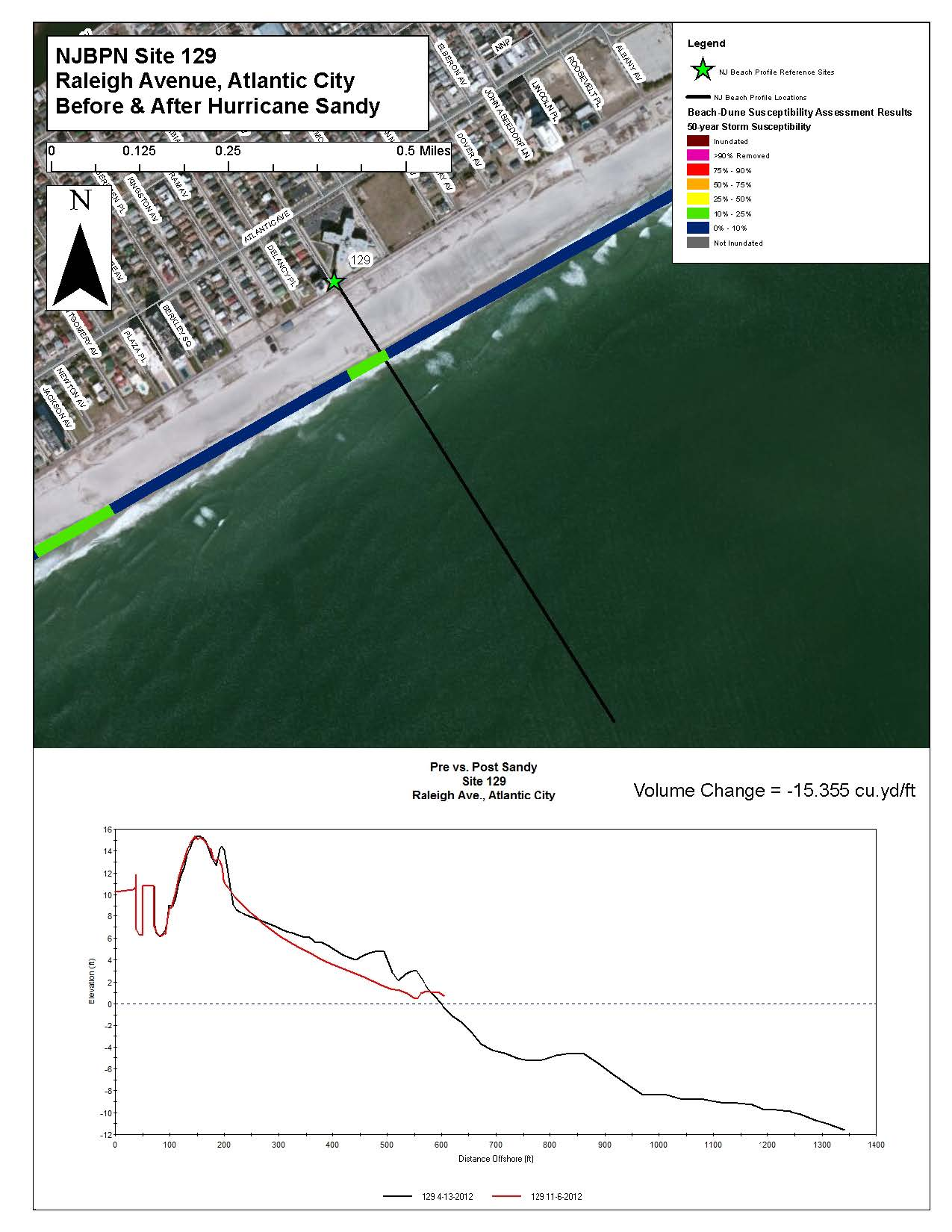
18 NJBPN 129 Raleigh Avenue, Atlantic City The photographs above were taken on April 13, 2012 (left) and November 6, 2012 (right). Raleigh Avenue lies in the middle of the Federal beach project and this meant that little damage was done. The dunes were invaded on the seaward slope depositing sand in the grass and knocking down an incipient foredune. Figure 8. This profile has been relatively stable over the past 25 years due to its mid island location and the past beach nourishment projects up drift of the site. The comparison plot between the pre and post storm survey shows little loss of the foredune but lowering of the berm. 18
19 19
20 NJBPN 128 Dorset Avenue, Ventnor City The photographs above were taken on April 13, 2012 (left) and November 6, 2012 (right). Dorset Avenue in Ventnor City also is located in the middle of the Federal project with excellent retention of the sand placed in Figure 9. The 2004 Federal beach nourishment project created a wide berm and dune which has remained relatively stable since that time. Minor amounts of sand were relocated seaward of the berm during Hurricane Sandy. 20
21 21
22 NJBPN 127 Benson Avenue, Margate City The photographs above were taken on April 13, 2012 (left) and November 6, 2012 (right). The relatively robust berm was cut down and pushed landward as a substantial deposit that included Benson Avenue and environs. The work was underway to excavate the sand at the sea side of the bulkhead to keep water from simply running over it. Figure 10. This beach has benefited from the nourishment projects that were constructed to the north. No dunes exist, but there is a wide berm that has remained relatively stable. Following Hurricane Sandy, sand was transported to the bulkhead filling the swale immediately seaward and continuing landward to Ocean Avenue. The ridge at the bulkhead was sand from the streets deposited back on the beach to be spread back toward the ocean. 22
23 23
24 NJBPN th Street, Longport The photographs above were taken on April 11, 2012 (left) and November 6, 2012 (right). The narrow beach allowed wave energy to explode on the seawall. The water bounced over it and crashed into the homes built at the base of the wall. Street end flooding, sand deposition to Atlantic Avenue and structural damage was spread along the shoreline. Figure 11. The concrete seawall stands in place of a dune system along this section of Longport. Hurricane Sandy s waves relocated the berm sand landward of the seawall and steepened the berm slope. Trucks were unloading material in piles over the wall back to the beach on November 6 th. 24
25 25
26 Summary & Conclusions Atlantic County Post Sandy Volume Changes Site Volume Change (cu yds/ft) Dates for Comparison Dune Failure Recent Beach Fill Oct 26, 2012 to Nov 11, 2012 Y Never Oct 26, 2012 to Nov 3, 2012 N 2006 & Oct 26, 2012 to Nov 3, 2012 No Dune Never Oct 26, 2012 to Nov 3, 2012 N Never Sep 18, 2012 to Nov 6, 2012 N June 4, 2012 to Nov 6, 2012 N Apr 13, 2012 to Nov 6, 2012 N Apr 13, 2012 to Nov 6, 2012 N Apr 13, 2012 to Nov 6, 2012 No Dune Never Apr 11, 2012 to Nov 6, 2012 No Dune 1990 Figure 12 shows a table of values for the 10 shoreline profile site locations in Atlantic County. The sand volume lost per foot of shoreline represents loss from the dune and the beach and does not include changes in the offshore region. These surveys were completed as rapidly as possible so no swimmers were brought to these sites. Dunes were damaged at some points, but performed in an excellent manner at sites numbered 131, 230, 130, 129 and
, Atlantic City, and Ventnor.")
27 Figure 13. This graphic shows the sand volume loss figures for each of the communities within the developed sections of the Atlantic County shoreline. Federal shore protection projects have occurred along this portion of the New Jersey shoreline in Brigantine (northern portion), Atlantic City, and Ventnor. In Brigantine, prior to the storm the engineered had beach had been eroded away. Atlantic City and Ventnor s engineered beach and dune systems have been maintained by the USACE recently and withheld the storm generated waves from breaching the dunes. All sites experienced berm erosion and dune losses except for site 127 in Margate, where sand had accumulated in front of the bulkhead adjacent to the street end (No dune at this location). The only true dune failure occurred in the national area on the north end of Brigantine (site 134), however sites 132 (Brigantine), 127 (Margate) and 126 (Longport) did not have dune systems in place prior to the storm and all experienced overwash of waves with sand being transported landward of the beach. 27
28 MUNICIPALITY NJBPN Site# Atlantic County Post Sandy Volume Changes Shoreline Change in the Zero Elev. Position Since Sandy Vol Change cu yds per ft Average of Sand Loss Between Adjacent Sites (cy/ft) Dune Failure Recent Beach Fill Distance Between Sites (FEET) Vol Change Cubic Yards Between Profiles (North to South) Cumulative Volume Change Cubic Yards (North to South) North Brigantine Natural Area Y Never 2,000 79,540 79,540 4th St. No. Brigantine N 2006 & , , ,668 15th St. So. Brigantine No Dune Never 4,762 43, ,813 43rd St. So. Brigantine N Never 7,042 85, ,474 Rhode Is. Ave. Atlantic City N , ,203 No. Carolina Ave. Atlantic City N ,265 90, ,657 Raleigh Ave. Atlantic City N , , ,125 Dorset Ave. Ventnor N ,419 44, ,941 Benson Ave. Margate No Dune Never 11,753 8, ,302 17th St. Longport No Dune ,737 36, ,132 Total Volume Loss for Atlantic County = 845,132 Figure 14. This table provides a summary of all the individual site sand volume losses from the dune and beach to the limit of the post Sandy survey. The total is derived by adding two adjacent site losses and dividing by two, then multiplying by the distance in feet between the two sites. This is known in the dredging industry as closed end averaging to obtain dredged volume along a channel. It is acknowledged that sand resources reside seaward of the short post storm surveys, but the need for speed dictated that taking additional time to survey to feet of water offshore would not add significantly to the losses seen within the beach/dune system. These longer surveys will be completed in due course however. A percentage of the sand carried offshore by Sandy will move back toward the beach over time in the absence of future storms. All sand lost from the dunes will require human intervention to replace, groom and revegetate in order to have the protection in place quickly. A natural dune system developing from scratch would require 15 to 20 years to re establish close to what was lost. 28
FINAL REPORT FOR 2012 ON THE CONDITION OF THE MUNICIPAL BEACHES IN THE CITY OF BRIGANTINE BEACH, ATLANTIC COUNTY, NEW JERSEY
 FINAL REPORT FOR 2012 ON THE CONDITION OF THE MUNICIPAL BEACHES IN THE CITY OF BRIGANTINE BEACH, ATLANTIC COUNTY, NEW JERSEY Photograph was taken November 3, 2012 from 10 th Street North looking south
Profile Locations: The following sites were surveyed during September and October 2012 and post-sandy by November 26, 2012 (Figure 1).
.") Introduction: An Assessment of Cape May County Beaches at the New Jersey Beach Profile Network (NJBPN) Sites After Hurricane Sandy Related to (DR-NJ 4086) The Richard Stockton College of NJ Coastal Research
Introduction: An Assessment of Cape May County Beaches at the New Jersey Beach Profile Network (NJBPN) Sites After Hurricane Sandy Related to (DR-NJ 4086) The Richard Stockton College of NJ Coastal Research
Hurricane Sandy: Beach-dune performance at New Jersey Beach Profile Network sites
 Hurricane Sandy: Beach-dune performance at New Jersey Beach Profile Network sites The Coastal Research Center (CRC) at the Richard Stockton College of New Jersey has been collecting beach and nearshore
SITE INVESTIGATIONS OF THE BEACH EROSION PROBLEM AT MAHO BEACH, ST. MAARTEN
 SITE INVESTIGATIONS OF THE BEACH EROSION PROBLEM AT MAHO BEACH, ST. MAARTEN Performed February 2003 Performed by: Dr. Lee E. Harris, Ph.D., P.E. Associate Professor of Ocean Engineering & Oceanography
STATUS REPORT FOR THE SUBMERGED REEF BALL TM ARTIFICIAL REEF SUBMERGED BREAKWATER BEACH STABILIZATION PROJECT FOR THE GRAND CAYMAN MARRIOTT HOTEL
 STATUS REPORT FOR THE SUBMERGED REEF BALL TM ARTIFICIAL REEF SUBMERGED BREAKWATER BEACH STABILIZATION PROJECT FOR THE GRAND CAYMAN MARRIOTT HOTEL performed by Lee E. Harris, Ph.D., P.E. Consulting Coastal
Using LIDAR to monitor beach changes: Goochs Beach, Kennebunk, Maine
 Geologic Site of the Month February, 2010 Using LIDAR to monitor beach changes: Goochs Beach, Kennebunk, Maine 43 o 20 51.31 N, 70 o 28 54.18 W Text by Peter Slovinsky, Department of Agriculture, Conservation
Oakwood Beach Storm Damage Prevention Project NJDEP-Bureau of Coastal Engineering Glenn Golden, Project Manager U.S. Army Corps Civil Works Programs
 Oakwood Beach Storm Damage Prevention Project NJDEP- Glenn Golden, Project Manager U.S. Army Corps Civil Works Programs Branch Dwight Pakan, Project Manager, Philadelphia District The State of New Jersey
http://www.nj.gov/dep/shoreprotection/storm.htmhris TUCKER
 COASTAL STORM SURVEY NEW JERSEY DEPARTMENT OF ENVIRONMENTAL PROTECTION BUREAU OF COASTAL ENGINEERING - TOMS RIVER NJ 12:00 P.M. TUESDAY, MARCH 1, 2005 NEW JERSEY COASTLINE INCLUDING RARITAN AND DELAWARE
Tropical Storm Debby. Post-Debby Beach/Dune Damage Assessment Report Sarasota Florida. By Weiqi Lin P.E., Ph.D. Coastal Resources/Community Services
 Tropical Storm Debby Post-Debby Beach/Dune Damage Assessment Report Sarasota Florida By Weiqi Lin P.E., Ph.D. Coastal Resources/Community Services June 29, 2012 BACKGROUND AND SUMMARY Tropical storm Debby
COASTAL DAMAGE INSPECTION SOUTHWEST VITI LEVU, FIJI AFTER CYCLONE SINA
 COASTAL DAMAGE INSPECTION SOUTHWEST VITI LEVU, FIJI AFTER CYCLONE SINA Brendan J. Holden SOPAC Technical Secretariat July 1992 SOPAC Technical Report 148 Prepared for: South Pacific Applied Geoscience
Remote sensing for the MTS
 Remote sensing for the MTS Jennifer M. Wozencraft Director, Program Manager, USACE National Coastal Mapping Program 24 June 2014, Innovative Technologies for a Resilient MTS Outline Background JALBTCX
Beach Management Funding Assistance Program
 FLORIDA DEPARTMENT OF ENVIRONMENTAL PROTECTION DIVISION OF WATER RESOURCE MANAGEMENT Beach Management Funding Assistance Program Local Government Funding Requests: Ranking Criteria for Beach and Inlet
Illinois Coastal Management Program 2011
 4 Coastal Erosion Assessment and Planning The Lake Michigan coast is a dynamic setting influenced by waves, ice, and changing lake levels. The potential for coastal erosion exists along nearly the entire
asbpa Preserving our coastal economy and ecology since 1926
 Preserving our coastal economy asbpa and ecology since 1926 HEALTHY BEACHES ARE VITAL TO OUR WAY OF LIFE People in the United States highly prize the thousands of miles of sandy beaches along our nation
Tropical Storm Debby
 Tropical Storm Debby Post-Debby Beach/Dune Damage Assessment Report (Draft) Sarasota Florida By Weiqi Lin P.E., Ph.D. Coastal Resources/Community Services June 28, 2012 BACKGROUND AND SUMMARY Tropical
Looking for property near the ocean?
 Looking for property near the ocean? Questions and Answers on Purchasing Coastal Real Estate in Massachusetts This brochure focuses on questions you should ask as a potential purchaser of coastal real
Strategic Beach Management Plan Southeast Atlantic Coast Region
 Page 1 of 66 Strategic Beach Management Plan Southeast Atlantic Coast Region Division of Water Resource Management Florida Department of Environmental Protection June 2015 Delray Beach Shore Protection
& Q A. on Purchasing Coastal Real Estate in South Carolina. S.C. Sea Grant Extension Program S.C. DHEC/Office of Ocean and Coastal Resource Management
 & Q A on Purchasing Coastal Real Estate in South Carolina S.C. Sea Grant Extension Program S.C. DHEC/Office of Ocean and Coastal Resource Management 1 Questions and Answers on Purchasing Coastal Real Estate
Coastal Erosion Risk Mitigation Strategies applied in a Small Island Developing State: The Barbados Model
 Coastal Erosion Risk Mitigation Strategies applied in a Small Island Developing State: The Barbados Model BY Dr. Leo Brewster, Director Coastal Zone Management Unit, Barbados Presented At UNFCCC Expert
THE HOMEOWNER S GUIDE TO THE COASTAL CONSTRUCTION CONTROL LINE PROGRAM (SECTION 161.053, FLORIDA STATUTES)
") THE HOMEOWNER S GUIDE TO THE COASTAL CONSTRUCTION CONTROL LINE PROGRAM (SECTION 161.053, FLORIDA STATUTES) The Florida Department of Environmental Protection Division OF Water Resource Management February
THE HOMEOWNER S GUIDE TO THE COASTAL CONSTRUCTION CONTROL LINE PROGRAM (SECTION 161.053, FLORIDA STATUTES) The Florida Department of Environmental Protection Division OF Water Resource Management February
SHORELINE STABILIZATION RECOMMENDATIONS FOR PLAYA DEL SECRETO MAYA RIVIERA, Q.R., MEXICO
 SHORELINE STABILIZATION RECOMMENDATIONS FOR PLAYA DEL SECRETO MAYA RIVIERA, Q.R., MEXICO NOVEMBER 2007 PHOTOGRAPH LOOKING SOUTH ALONG PLAYA DEL SECRETO PREPARED BY: Lee E. Harris, Ph.D., P.E. Consulting
Long Island s Dynamic South Shore
 Long Island s Dynamic South Shore A Primer on the Forces and Trends Shaping Our Coast Jay Tanski Long Island s Dynamic South Shore A Primer on the Forces and Trends Shaping Our Coast Introduction Long
Evaluating the Condition of Seawalls/Bulkheads
 Volume 2 Evaluating the Condition of Seawalls/Bulkheads By: Coastal Systems International, Inc. Typical bulkhead under construction Seawalls and bulkheads (walls) provide shoreline stabilization for many
RESUME for Christopher G. Creed, P.E.
 Page One of Five Current Position Senior Engineer / Vice-President for Olsen Associates, Inc. a coastal engineering consulting firm in Jacksonville, Florida. Education Master of Civil Engineering, 1992.
City of Indian Rocks Beach, Florida NFIP Number 125117
 City of Indian Rocks Beach, Florida NFIP Number 125117 Floodplain Management Plan / Local Mitigation Strategy Annual Report - September 2015 Introduction The City of Indian Rocks Beach has been an active
An Initial Assessment of the Impacts of Sea Level Rise to the California Coast
 An Initial Assessment of the Impacts of Sea Level Rise to the California Coast Photo by D. Revell 2/23/08 California Coastal Records Project Dr. David Revell and Matt Heberger, P.E. Dr. Peter Gleick, Bob
RESTORATION AND ENHANCEMENT OF SOUTHERN CALIFORNIA LAGOONS
 RESTORATION AND ENHANCEMENT OF SOUTHERN CALIFORNIA LAGOONS by Hany Elwany, Ph.D. Scripps Institution of Oceanography Headwaters to Oceans Conference 25 October 2003 CE Ref #03-22 San Diego County Lagoons
AQUITAINE COAST (FRANCE)
") AQUITAINE COAST (FRANCE) Contact: Jean Christophe LE BRETON Anne GUCHAN Conseil Regional d Aquitaine 14 Rue François de Sourdis 33077 Bordeaux (CEDEX) 10 Tel: +34 055 757 83 06 Fax: +34 055 656 38 06 e-mail:
AQUITAINE COAST (FRANCE) Contact: Jean Christophe LE BRETON Anne GUCHAN Conseil Regional d Aquitaine 14 Rue François de Sourdis 33077 Bordeaux (CEDEX) 10 Tel: +34 055 757 83 06 Fax: +34 055 656 38 06 e-mail:
Goal 1 To protect the public health, safety and property from the harmful effects of natural disasters.
 Plan Framework for Coastal Management The purpose of this element is to provide for the protection of residents and property in within the coastal area of the host community, and to limit expenditures,
Raritan Bay and Sandy Hook Bay Highlands, New Jersey Coastal Storm Risk Management Feasibility Study. Appendix B Engineering July 2015
 Raritan Bay and Sandy Hook Bay Highlands, New Jersey Coastal Storm Risk Management Feasibility Study Appendix B Engineering July 2015 This page is intentionally left blank. Raritan Bay and Sandy Hook Bay,
COASTAL SETBACK AND CONTROL LINES* * Cross References: Coastal construction code, 22-351 et seq.
 CHAPTER 62, ARTICLE XII. COASTAL SETBACK AND CONTROL LINES* * Cross References: Coastal construction code, 22-351 et seq. Sec. 62-4201. Definitions and rules of construction. For the purpose of this article,
SECTION 10.0 MANAGEMENT UNIT 5: HORNSEA
 10.1 Summary Information 10.1.1 Location SECTION 10.0 MANAGEMENT UNIT 5: HORNSEA The limits of Management Unit 5, a 2.9km stretch of shoreline fronting the town of Hornsea on the Holderness coast, are
St Lucia. Wise practices for coping with. i b bea n Se a
 Wise practices for coping with St Lucia Car i b bea n Se a Fisheries Department, St Lucia Physical Planning Department, St Lucia University of Puerto Rico, Sea Grant College Program Caribbean Development
Inlets Online: A Tutorial for Evaluating Inlet/Beach Processes Using Aerial Photography
 Inlets Online: A Tutorial for Evaluating Inlet/Beach Processes Using Aerial Photography by Mark R. Byrnes, Feng Li, and Julie D. Rosati PURPOSE: This Coastal and Hydraulics Engineering Technical Note (CHETN)
SARASOTA COUNTY LIDO KEY HURRICANE & STORM DAMAGE REDUCTION PROJECT
 SARASOTA COUNTY LIDO KEY HURRICANE & STORM DAMAGE REDUCTION PROJECT Information Presentation BOCC Joint Meeting City of Sarasota Sarasota County US Army Corps of Engineers 22 October 2013 Sarasota, Florida
Interpreting Federal Emergency Management Agency Flood Maps and Studies in the Coastal Zone
 Interpreting Federal Emergency Management Agency Flood Maps and Studies in the Coastal Zone Publication Date: October 2015 Table of Contents FEMA Flood Insurance Rate Maps and Flood Insurance Studies.
St. Lucie County - South Beaches Regional Beach Restoration
 St. Lucie County - South Beaches Regional Beach Restoration After Hurricane Sandy October 2012 Post - Construction May 2013 Tem Fontaine, P.E., M.S. Michael Walther, P.E., D.CE Ft. Pierce Inlet St. Lucie
Updated Federal Emergency Management Agency Flood Insurance Rate Maps and Zoning Ordinance Update. July 16, 2015 Policy Committee
 Updated Federal Emergency Management Agency Flood Insurance Rate Maps and Zoning Ordinance Update July 16, 2015 Policy Committee FEMA Map Update Costal Analysis and mapping study by FEMA in 2009 Changes
Window damage to high-rise condominium (R145.3).
.") At the south end of Marco Island, nine high rise condominiums sustained minor wind damages, to include, broken windows, torn or destroyed screen porch enclosures, and damaged storm shutters (Photo 17).
At the south end of Marco Island, nine high rise condominiums sustained minor wind damages, to include, broken windows, torn or destroyed screen porch enclosures, and damaged storm shutters (Photo 17).
Index. protection. excavated drop inlet protection (Temporary) 6.50.1 6.51.1. Block and gravel inlet Protection (Temporary) 6.52.1
 6.50.1 6.51.1. Block and gravel inlet Protection (Temporary) 6.52.1") 6 Index inlet protection excavated drop inlet protection (Temporary) 6.50.1 HARDWARE CLOTH AND GRAVEL INLET PROTECTION Block and gravel inlet Protection (Temporary) sod drop inlet protection ROCK DOUGHNUT
6 Index inlet protection excavated drop inlet protection (Temporary) 6.50.1 HARDWARE CLOTH AND GRAVEL INLET PROTECTION Block and gravel inlet Protection (Temporary) sod drop inlet protection ROCK DOUGHNUT
The Coast of Crystal Cove Orange County, California
 The Coast of Crystal Cove Orange County, California by Hany Elwany, Ph.D. Scripps Institution of Oceanography Megan Hamilton, M.Sc. Coastal Environments Robert Robinson Dept. of Parks & Recreation Headwaters
PLANNED UNIT DEVELOPMENT & SIDEWALK WAIVER REQUEST STAFF REPORT Date: November 7, 2013
 PLANNED UNIT DEVELOPMENT & SIDEWALK WAIVER REQUEST STAFF REPORT Date: November 7, 2013 NAME LOCATION Audubon Properties, LLC. 4700 & 4960 Dauphin Island Parkway West side of Dauphin Island Parkway, 580
COST AND MAINTENANCE OF LIVING SHORELINES
 COST AND MAINTENANCE OF LIVING SHORELINES Photo: C. Verlinde, University of Florida Sea Grant Extension Debbie L. DeVore South Florida Coastal Program Coordinator What are Living Shorelines? Shoreline
FINAL INTEGRATED GENERAL REEVALUATION REPORT AND SUPPLEMENTAL ENVIRONMENTAL IMPACT STATEMENT
 FINAL INTEGRATED GENERAL REEVALUATION REPORT AND SUPPLEMENTAL ENVIRONMENTAL IMPACT STATEMENT BREVARD COUNTY, FLORIDA HURRICANE AND STORM DAMAGE REDUCTION PROJECT MID-REACH SEGMENT U.S. Army Corps of Engineers
NEW JERSEY SEA GRANT COLLEGE PROGRAM MANUAL FOR COASTAL HAZARD MITIGATION. Compiled by Thomas O. Herrington
 NEW JERSEY SEA GRANT COLLEGE PROGRAM MANUAL FOR COASTAL HAZARD MITIGATION Compiled by Thomas O. Herrington 2 PREFACE New Jersey is often used as an example of a natural system gone awry. The unflattering
Most informed people realize that cumulative impacts have had
 Welcome to the First Issue of Rivers & Coast! The goal of the new Rivers & Coast newsletter is to keep readers well informed of current scientific understanding behind key environmental issues related
Why should communities invest in resiliency? What are the steps communities can take to become more resilient?
 Community Preparedness for Flood Resiliency Nina Peek, AICP New York Planning Federation Board of Directors Senior Technical Director AKRF, Inc. Focus of Today s Presentation Why should communities invest
Develop hazard mitigation policies and programs designed to reduce the impact of natural and human-caused hazards on people and property.
 6.0 Mitigation Strategy Introduction A mitigation strategy provides participating counties and municipalities in the H-GAC planning area with the basis for action. Based on the findings of the Risk Assessment
ebb current, the velocity alternately increasing and decreasing without coming to
 Slack water (slack tide): The state of a tidal current when its velocity is near zero, especially the moment when a reversing current changes its direction and its velocity is zero. The term is also applied
New Coastal Study for Puerto Rico FIRMs. Paul Weberg, FEMA RII Mat Mampara, Dewberry Jeff Gangai, Dewberry Krista Collier, Baker
 New Coastal Study for Puerto Rico FIRMs Paul Weberg, FEMA RII Mat Mampara, Dewberry Jeff Gangai, Dewberry Krista Collier, Baker September 2007 Project Team FEMA Region II Program Manager Collaboration
NANTASKET BEACH DCR Reservation Hull, Massachusetts
 Coastal Storm Damage Reduction Report DRAFT Feasibility Report and Environmental Assessment NANTASKET BEACH DCR Reservation Hull, Massachusetts US ARMY CORPS OF ENGINEERS New England District May 2014
Table 4.9 Storm Drain Inlet Protetion Applicable for
 BMP C220: Storm Drain Inlet Protection Purpose To prevent coarse sediment from entering drainage systems prior to permanent stabilization of the disturbed area. Conditions of Use Type of Inlet Protection
Damage to Rest Beach infrastructure.
 Rest Beach Wilma inflicted severe erosion, flooding, and overwash, and substantially destroyed the entire park s recreational infrastructure (Photo 57). Two beach access walkways were destroyed along with
Mouth of the Columbia River Jetties Major Rehabilitation Study
 Mouth of the Columbia River Jetties Major Rehabilitation Study PNWA Port of Vancouver January 29, 2010 US Army Corps of Engineers Project Overview Background Corps Guidance for Major Rehab Project Alternatives
BEACH NOURISHMENT COMBINED WITH SIC VERTICAL DRAIN IN MALAYSIA.
 BEACH NOURISHMENT COMBINED WITH SIC VERTICAL DRAIN IN MALAYSIA. Claus Brøgger 1 and Poul Jakobsen 2 The present paper presents measurements and results from a three year full scale Pilot Project with the
http://library1.municode.com/default/docview/10251/1/101/103
 Page 1 of 8 ARTICLE II. FLOOD DAMAGE PREVENTION* *Cross references: Buildings and building regulations, ch. 67; floor elevation standards, 67-32; flood damage prevention for utility systems, 67-34; drainage
Bolinas Lagoon Ecosystem Restoration Feasibility Project Marin County Open Space District
 Bolinas Lagoon Ecosystem Restoration Feasibility Project Marin County Open Space District With Funding from the California State Coastal Conservancy & the U.S. Army Corps of Engineers July 2006 Bolinas
Hazards of the Jamaican Coastline ERODING BEACHES: A RESPONSE TO RISING SEA LEVEL?
 Hazards of the Jamaican Coastline ERODING BEACHES: A RESPONSE TO RISING SEA LEVEL? This is the fourth in a series of articles on Hazards of the Jamaican Coastline contributed by the Marine Geology Unit,
REGIONAL SEDIMENT MANAGEMENT: A GIS APPROACH TO SPATIAL DATA ANALYSIS. Lynn Copeland Hardegree, Jennifer M. Wozencraft 1, Rose Dopsovic 2 INTRODUCTION
 REGIONAL SEDIMENT MANAGEMENT: A GIS APPROACH TO SPATIAL DATA ANALYSIS Lynn Copeland Hardegree, Jennifer M. Wozencraft 1, Rose Dopsovic 2 ABSTRACT: Regional sediment management (RSM) requires the capability
2015 CRS Community Outreach. City of Folly Beach, South Carolina Flood Plain Management Offices PO Box 48 Folly Beach, SC 29439 843-588-2447 ext 1838
 City of Folly Beach, South Carolina Flood Plain Management Offices PO Box 48 Folly Beach, SC 29439 843-588-2447 ext 1838 The dark line around this map delineates the extent of the Special Flood Hazard
Application of the Beach-fx Economic Model in St. Johns County, Florida
 Application of the Beach-fx Economic Model in St. Johns County, Florida Jason Engle, P.E. Jacksonville District USACE US Army Corps of Engineers Beach-fx Introduction St. Johns County Study Area Overview
Coastal Change from Hurricane Sandy and the 2012 13 Winter Storm Season: Fire Island, New York
 Coastal Change from Hurricane Sandy and the 2012 13 Winter Storm Season: Fire Island, New York By Cheryl J. Hapke, Owen Brenner, Rachel Hehre, and B.J. Reynolds Open-File Report 2013 1231 U.S. Department
Impacts of Global Warming on North Carolina s Coastal Economy
 Impacts of Global Warming on North Carolina s Coastal Economy IMPACTS OF GLOBAL WARMING ON NORTH CAROLINA S COASTAL ECONOMY Key Findings Global warming is projected to have significant impacts on North
Planning for Sea Level Rise before and after a Coastal Disaster
 Chapter 8 Planning for Sea Level Rise before and after a Coastal Disaster James G. Titus INTRODUCTION Ocean beach resorts in the United States have always faced erosion and storm damage. At first, these
PALM BEACH COUNTY DEPARTMENT OF ENVIRONMENTAL RESOURCES MANAGEMENT
 PALM BEACH COUNTY DEPARTMENT OF ENVIRONMENTAL RESOURCES MANAGEMENT ENVIRONMENTAL ENHANCEMENT & RESTORATION DIVISION 2014 PALM BEACH COUNTY DEPARTMENT OF ENVIRONMENTAL RESOURCES MANAGEMENT MISSION STATEMENT
FAIRFAX WATER OCCOQUAN RESERVOIR SHORELINE EASEMENT POLICY. February 17, 2011
 FAIRFAX WATER OCCOQUAN RESERVOIR SHORELINE EASEMENT POLICY February 17, 2011 I. Purpose The Occoquan Reservoir (the "Reservoir"), located in Fairfax and Prince William Counties, Virginia, was constructed
Homeowner s Guide to Drainage
 Homeowner s Guide to Drainage a scottsdale homeowner s guide to drainage produced by the city of scottsdale s stormwater management division Transportation Department TABLE OF CONTENTS Introduction 2 Drainage
30 DAY PUBLIC NOTICE MAINTENANCE DREDGING OF THE FEDERAL NAVIGATION PROJECT IN COHASSET HARBOR COHASSET AND SCITUATE, MASSACHUSETTS
 .-ro:'j - I US Army Corps of Engineers r& New England District 696 Virginia Road Concord, MA 01742-2751 Public Notice In Reply Refer to: Mr. Craig Martin nae-pn-nav@usace.army.mil Programs/Project Management
Pine Creek Culvert Upgrade $ 560,000. Located at exiting hump dike, just south of Fire Training Center
 To: BOS From: Joseph Michelangelo, P.E. Director of Public Works Re: CDBG-DR Pine Creek Culvert Upgrade Date: April 20, 2015 On June 19, 2014, the Town of Fairfield was awarded the above referenced project
Post Hurricane Sandy Maritime Forest Creation Bradley Beach, NJ
 Post Hurricane Sandy Maritime Forest Creation Bradley Beach, NJ A Small Scale Project with Large Scale Application Prepared by Capt. Al Modjeski American Littoral Society OUTLINE Background Objectives
ECONOMIC ANALYSIS FLOOD DAMAGE REDUCTION. Lower Carmel River Floodplain Restoration and Enhancement Project
 ECONOMIC ANALYSIS FLOOD DAMAGE REDUCTION Lower Carmel River Floodplain Restoration and Enhancement Project I. Description of the Project and its Relationship to Other Projects in the Proposal The Lower
Neversink River East Branch
 Neversink River East Branch Management Unit 10 Summary of Post-Flood Recommendations Intervention Level Full restoration of the stream reach including the eroding bank site between Station 38380 and Station
CONTINUING EROSION IN SOUTHEASTERN COASTAL MISSISSIPPI - POINT AUX CHENES BAY, WEST GRAND BAY, MIDDLE BAY, GRANDE BATTURE ISLANDS: 1995-1997
 Summary of a Poster Presented at the: Sixty-Second Annual Meeting of the Mississippi Academy of Sciences in Biloxi, Mississippi February 26-27, 1998 ===============================================================
Coastal Engineering Indices to Inform Regional Management
 Coastal Engineering Indices to Inform Regional Management Lauren Dunkin FSBPA 14 February 2013 Outline Program overview Standard products Coastal Engineering Index Conclusion and future work US Army Corps
HAZUS 2014. 7 th Annual Conference
 HAZUS 2014 7 th Annual Conference HAZUS Comparison of Storm Surge Levels from Different Hurricanes to the Newest SLOSH Models for Berkeley, Charleston, & Dorchester Counties Along the SC Coastline. Charlie
New Jersey Field Office Relocation By Eric Schrading
 New Jersey Field Office Relocation By Eric Schrading The New Jersey Field Office has moved! It took 12 movers and three moving vans two days to get everything at our old location in Pleasantville, NJ moved
The success of the hurricane protection around Chevron s refinery at Pascagoula, MS, during Katrina
 The success of the hurricane protection around Chevron s refinery at Pascagoula, MS, during Katrina Dr J.W. van der Meer, Dr C. Cooper, M.J. Warner, H. Adams-Morales and G.J. Steendam Abstract and presentation
POINTS TO CONSIDER WHEN BUYING SHORELINE PROPERTY
 POINTS TO CONSIDER WHEN BUYING SHORELINE PROPERTY You re considering buying a piece of property. You ve found two properties which meet your needs and interest you. Both properties are about two acres
Lower Breton Sound Sediment Diversion Conceptual Engineering Design Presentation
 EXPERT PANEL ON DIVERSION PLANNING AND IMPLEMENTATION Lower Breton Sound Sediment Diversion Conceptual Engineering Design Presentation February 12, 2015 Topics I. Introduction II. Geotechnical Study III.
Martin County Coastal GIS Program St Lucie Inlet Planning Tool
 Martin County Coastal GIS Program St Lucie Inlet Planning Tool Alexandra Carvalho, Ph.D., GISP Kathy Fitzpatrick, P.E. Jessica Garland Martin County, Florida Presentation Overview County Coastal Programs
1. Executive Summary
 1. Executive Summary 1.1. The character of the coast of Wales is defined by continuous change, erosion and accretion, a dynamism that will increase in the future with climate change driven sea level rise
PERPETUAL STORM DAMAGE REDUCTION EASEMENT Pre-Existing Structure. THIS PERPETUAL STORM DAMAGE REDUCTION EASEMENT is made BY AND BETWEEN.
 PERPETUAL STORM DAMAGE REDUCTION EASEMENT Pre-Existing Structure THIS PERPETUAL STORM DAMAGE REDUCTION EASEMENT is made BY AND BETWEEN residing at herein after referred to as Grantor, AND Suffolk County
1. GENERAL ADVISORY BASE FLOOD ELEVATION (ABFE) QUESTIONS
 QUESTIONS") INTRODUCTION As communities begin to recover from the devastating effects of Hurricane Sandy, it is important to recognize lessons learned and to employ mitigation actions that ensure structures are rebuilt
INTRODUCTION As communities begin to recover from the devastating effects of Hurricane Sandy, it is important to recognize lessons learned and to employ mitigation actions that ensure structures are rebuilt
Shoreline Master Programs Handbook Chapter 15, Shoreline Stabilization
 Shoreline Master Programs Handbook Chapter 15, Shoreline Stabilization Publication Number: 11-06-010 7/15 Contents Introduction... 1 Chapter overview... 2 Description of shoreline stabilization... 2 Design
Guideline: A risk assessment approach to development assessment in coastal hazard areas
 Guideline: A risk assessment approach to development assessment in coastal hazard areas Prepared by: Environment Planning, Department of Environment and Heritage Protection State of Queensland, 2013. The
Storm Surge: A Rising Danger by Andrew M. Dzambo
 Storm Surge: A Rising Danger by Andrew M. Dzambo Citizens of the United States are migrating towards the nation s coasts; according to the U.S. Census Bureau, the U.S. coastal watershed county population
Flood & Erosion Board Flood Mitigation Plan
 1/8/2015 Flood & Erosion Board Flood Mitigation Plan Presentation to Board of Selectman January 8, 2015 Fairfield Hurricane Inundation Map Yellow Cat I, lowest elevations Orange Cat II, slightly higher
Project Report. A Fiscal Impact Analysis of the Saco River & Camp Ellis Beach Shore Damage Mitigation Project
 Project Report A Fiscal Impact Analysis of the Saco River & Camp Ellis Beach Shore Damage Mitigation Project Presented To: Richard Michaud, City Administrator City of Saco 300 Main Street Saco, Maine 04072
DOÑA ANA COUNTY DESIGN STORM CRITERIA GUIDELINES FOR COMMERCIAL AND RESIDENTIAL SITES. Run-off Analysis Methods
 DOÑA ANA COUNTY DESIGN STORM CRITERIA GUIDELINES FOR COMMERCIAL AND RESIDENTIAL SITES Run-off Analysis Methods This document sets forth the minimum design, technical criteria and specifications for the
Frequently Asked Land Use Permitting Questions Post Superstorm Sandy Updated July 2nd, 2013
 Frequently Asked Land Use Permitting Questions Post Superstorm Sandy Updated July 2nd, 2013 Most of the recovery and repair activities public agencies, businesses, and homeowners need to conduct as a result
HURRICANE IKE DAMAGE SURVEY
 P 2.41 HURRICANE IKE DAMAGE SURVEY Timothy P. Marshall* Haag Engineering Co. Irving, Texas 1. INTRODUCTION The author conducted both aerial and ground damage surveys of the upper Texas coast after Hurricane
REHABILITATION OF THE CHICAGO SHORELINE: A COASTAL ENGINEERING PERSPECTIVE
 REHABILITATION OF THE CHICAGO SHORELINE: A COASTAL ENGINEERING PERSPECTIVE Michael Krecic, P.E. Senior Engineer Taylor Engineering, Inc. 9000 Cypress Green Drive Jacksonville, FL 32256 Mark Wagstaff, P.E.
DEPARTMENT OF THE ARMY OFFICE OF THE CHIEF OF ENGINEERS WASHINGTON, D.C. 20314-1000
 DEPARTMENT OF THE ARMY OFFICE OF THE CHIEF OF ENGINEERS WASHINGTON, D.C. 20314-1000 CEMP-SPD (l105-2-10a) APR 1 5 2012 THE SECRETARY OF THE ARMY 1. I submit for transmission to Congress my report on coastal
Effect of Storms on Barrier Island Dynamics, Core Banks, Cape Lookout National Seashore, North Carolina, 1960 2001
 Prepared in cooperation with the National Park Service and East Carolina University Effect of Storms on Barrier Island Dynamics, Core Banks, Cape Lookout National Seashore, North Carolina, 1960 2001 Scientific
CONSTRUCTION DOCUMENTATION REPORTS
 ENGINEERED BERM PROJECT FOR SHORE PROTECTION ALONG CENTRAL AND SOUTHERN BREVARD COUNTY, FLORIDA Project Description and History (2005-2009) APPENDIX C CONSTRUCTION DOCUMENTATION REPORTS 2005 through 2009.
Hurricanes and Storm Surge www.hcfcd.org/tropicalweather
 Hurricanes and Storm Surge www.hcfcd.org High-level winds fl ow outward Strong surface winds spiral inward EYE Calm, sometimes cloudfree, sinking air Air sinks in calm area at the storm s eye THUNDERSTORMS
Storm tide is the water level rise during a storm due to the combination of storm surge and the astronomical tide.
 INTRODUCTION TO STORM SURGE Introduction to Storm Surge BOLIVAR PENINSULA IN TEXAS AFTER HURRICANE IKE (2008) What is Storm Surge? Inland Extent Storm surge can penetrate well inland from the coastline.
Future of our coasts: Potential for natural and hybrid infrastructure to enhance ecosystem and community resilience Ariana Sutton-Grier
 Future of our coasts: Potential for natural and hybrid infrastructure to enhance ecosystem and community resilience Ariana Sutton-Grier University of Maryland & National Oceanic and Atmospheric Administration
APPENDICES G) DETAILED BACKBONE INFRASTRUCTURE CONSTRUCTION COST ESTIMATE SUMMARY
 DETAILED BACKBONE INFRASTRUCTURE CONSTRUCTION COST ESTIMATE SUMMARY") ALAMEDA POINT MASTER INFRASTRUCTURE PLAN March 31, 2014 APPENDICES G) DETAILED BACKBONE INFRASTRUCTURE CONSTRUCTION COST ESTIMATE SUMMARY Carlson, Barbee & Gibson, Inc. Backbone Infrastructure Engineer
ALAMEDA POINT MASTER INFRASTRUCTURE PLAN March 31, 2014 APPENDICES G) DETAILED BACKBONE INFRASTRUCTURE CONSTRUCTION COST ESTIMATE SUMMARY Carlson, Barbee & Gibson, Inc. Backbone Infrastructure Engineer
Outlet stabilization structure
 Overview of Sedimentation and Erosion Control Practices Practice no. 6.41 Outlet stabilization structure Erosion at the outlet of channels, culverts, and other structures is common, and can cause structural