Flooding and Flood Threats on Trenton Island
|
|
|
- Silas Russell
- 8 years ago
- Views:
Transcription
1 Mitigation Success Trenton Island, Pierce County, Wisconsin Background: Trenton Island is located in the unincorporated area of Trenton Township, Pierce County, in northwestern Wisconsin. Often called Pucketville, it is middle of the Mississippi River and in the floodway. Developed prior to Pierce County s adoption of floodplain management regulations, which prohibit structures in the floodway, the homes and businesses of Trenton Island are on hazardous ground. (See Appendix A for floodway and floodplain definitions.) For years the residents of Trenton Island have suffered severe and repetitive flood damage. Major floods in 1952, 1965, 1969, 1993 and 1997 devastated the community, damaging homes, businesses and island infrastructure. Wells used for drinking water were contaminated, overflowing sewage spread bacteria to flooded buildings and down the Mississippi River, businesses lost customers, temporary housing costs grew as residents forced from their homes spent weeks in costly lodging. Minor flooding in 1967, 1975 and 1986 also damaged the community. With each flood, cleanup and repair costs mounted along with the costs of emergency response and repairs sustained by county, state and federal governments. Flooding and Flood Threats on Trenton Island Flood Damages Occur When Water Level is 14 Feet or More Above Flood Stage Crest and Height Figures are in Feet Above Flood Stage Year Crest Date Type Begin Height End Height Duration N/A Major N/A N/A N/A N/A N/A /19 Major 04/ / Days /24 Threat /06 Minor 04/ / Days /17 Major 04/ / Days /16 Threat Threat /01 Minor 04/ / Days /04 Threat /25 Threat /22 Threat /11 Threat /20 Threat /07 Minor 04/ / Days /27 Threat /14 Threat /28 Major 06/ / Days /12 Major 04/ / Days /28 Major 04/ / Days 1
 For years the residents of Trenton Island have suffered severe and repetitive flood damage.")
2 Zoning and Floodplain Regulations: Trenton Island is in the Mississippi River floodway. Federal, state and Pierce County floodplain management and zoning standards for the floodway prohibit new construction and tightly regulate existing structures. All existing structures in a floodway are classified as nonconforming uses, and cannot be repaired or replaced if the cumulative damage from one or more floods exceeds fifty percent of the structure's present assessed value. In addition, any remodeling is limited to fifty percent of the structure's present assessed value, over the life of the structure. Any repair or remodeling effort is considered to be a conditional use, which requires a public hearing. The public hearing fee is $ All actions or approvals granted by Pierce County are subject to review by the Wisconsin Department of Natural Resources (DNR). The DNR may file objections to plans and Pierce County approvals. Many of Trenton Island s structures were damaged extensively by the 1993 floodwaters. For some, the losses exceeded fifty percent of the structure s value and thus subjected them to the floodway regulation prohibiting repair or replacement of the structure. Most of Trenton Island (area within red border) is visible in the photo shot during the 2001 flood. Channels of the Mississippi are at the bottom, top and right of the Island. All of Trenton Island is in the floodway. Project: The floods of 1993 hit Trenton Island hard and Pierce County officials and island residents faced some difficult choices. Local residents who wanted to rebuild could be in violation of floodplain ordinances, and; they would remain in the floodway. Also, given the island s flooding history and its location in the floodway, Trenton Island would surely flood again. Clearly here was a recurring problem in need of a permanent solution. A Presidential Disaster Declaration for the 1993 Wisconsin flooding made federal disaster dollars available for mitigation projects through FEMA/State Hazard Mitigation Grant Program (HMGP). To prevent the suffering, damage and expense wrought by 2

3 repetitive flooding, Pierce County officials sought participation in a voluntary property acquisition project through the HMGP. The purpose of the project was to: 1. Acquire flood prone properties from willing sellers. Those properties included homes, businesses and vacant parcels on Trenton Island and the surrounding communities of Bay City, Hagar City and Spring Valley. 2. Provide property owners with an opportunity to recoup investments and equity. 3. Enact perpetual deed restrictions on acquired properties to ensure land use would remain compatible with open space, recreational or wetlands management practices. These restrictions are in compliance with HMGP regulations and sound floodplain management practices. 4. Reduce the need for future county, state and federal disaster response and recovery expenditures. Shown above during the flood of 1993, many of these buildings were purchased and the lots returned to open space. The property owner of the two homes on the far left chose not to sell. The homes were flooded in 1997 and Pierce County officials prepared and submitted a project application to the Wisconsin Emergency Management (WEM), the state administrator of the HMGP. Following their review the project was submitted to FEMA for approval and federal funding. Under the regulations of the HMGP, FEMA would provide 75% of the six million dollar project costs. The remaining 25% would be split between WEM and the Wisconsin Department of Administration Division of Housing, which provided funding through a Community Development Block Grant for Disaster Relief. To supplement funds provided by the HMGP, WEM and the Wisconsin Department of Administration Division of Housing, project administrators raised $187, by selling salvage from purchased structures. Two additional homes were bought and removed from the floodway with salvage funds and $52, of the salvage income was used to help fund another HMGP project in the City of Darlington. 3

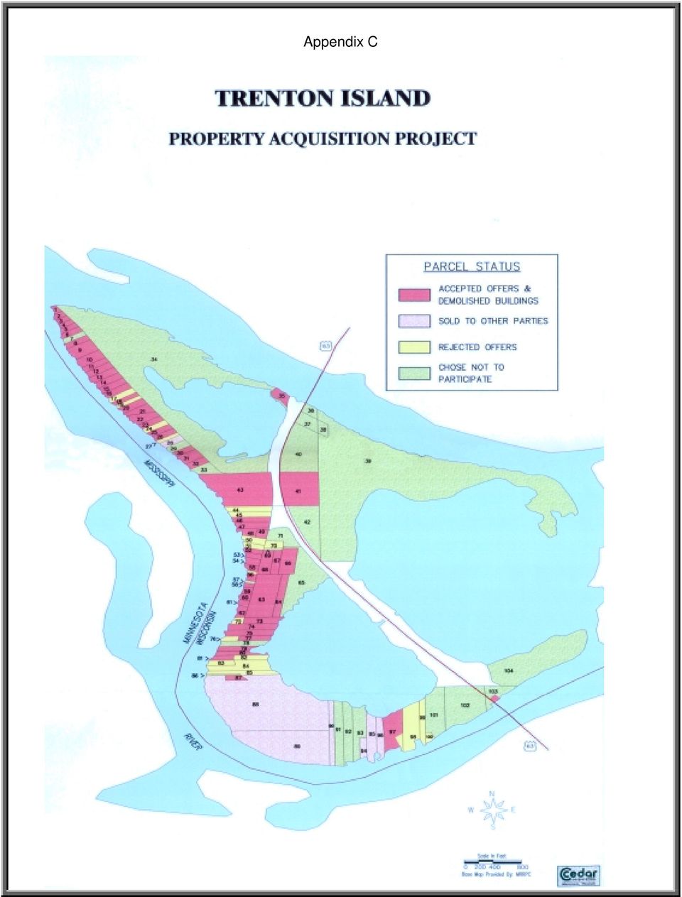
4 With state and FEMA approval complete and funding in place, Pierce County project administrators began implementing the project in early Over the next three years, owners of fifty-nine Trenton Island properties accepted offers for buyout from the Pierce County HMGP project. Seven more owners sold their properties to the Red Wing Area Fund, a local conservation group. In all sixty-eight or sixty-five percent of island properties were purchased and returned to open space. (See Appendix C) Some Trenton Island residents were initially reluctant to participate in the buyout. However, the specter of rebuilding again, or of not being able to rebuild and still be in compliance with floodplain regulations, convinced them to sell. Others like Cash Gardas, an island resident since 1931, welcomed an opportunity to leave. I ve been through, let s see one, two, three, four four floods, he says. I am ready to leave the floodplain. He adds with resignation, There ain t much you can do about it when it wants to rain and keep raining. In addition to providing all property owners with the fair market value of their properties as stipulated under the HMGP, owners of primary residences were compensated for moving expenses and replacement housing cost differential as required under Wisconsin state law. The housing cost differential payment made up the difference, if any, between the acquisition cost and the reasonable cost to purchase a comparable replacement, or the actual cost of the replacement dwelling, whichever is less. During the implementation of the project, the Pierce County official in charge of administering the project kept Trenton Island residents, and others in the interested public, well informed of the particulars and progress of the buyout. Through newsletters, meetings and personal contacts, project participants and others were informed and assisted with all aspects of the acquisition and relocation processes. The administrator also served as a liaison between numerous government agencies and individual property owners. Open communication between all parties helped make the difficult process of leaving home and property easier to bear. Today much of Trenton Island is now open space. Though some residents and businesses remain and likely will again suffer from flooding, project participants are now free from the anguish and loss of Trenton Island flooding. I ve been through, let s see one, two, three, four four floods. I am ready to leave the floodplain. Cash Gardas Trenton Island resident and project participant Photographed after the 2001 flood, this former home site shows the effects of high water. By participating in the buyout, the former property owner avoided thousands of dollars in flood damage. 4
 Some Trenton Island residents were initially reluctant to participate in the buyout.")
5 The majority of those who chose to sell and leave the island did not go far. Over eighty per cent of those participating in the buyout relocated within five miles of Trenton Island. (See Appendix D) Most attend the same schools, work at the same jobs, shop in the same stores and are within visiting distance of their former neighbors. Now unthreatened by flood losses, they remain a part of the economic and social fabric of the local community. Benefits: The floods of April 1997 and 2001 clearly illustrated the benefits of the acquisition and removal of vulnerable properties in the Trenton Island floodway. The crest of the 1993 flood on Trenton Island was 1.25 feet above flood stage. In 1997, the crest was almost two feet higher than the 1993 flood at 3.2 feet above flood stage and, in 2001, the crest was higher yet at 3.8 feet above flood stage. The extensive losses of the 1993 flooding would of have been multiplied in the two succeeding floods, and in future floods, if the homes and businesses participating in the project had remained on Trenton Island. Most of the twenty remaining homes and businesses, which chose not to participate in the buyout, again suffered flood damage in both 1997 and According to one business owner, the 2001 flood caused more damage to his structure than any previous flood. Though beyond the scope of this report, these damages can be quantified and the financial benefits of the buyout project be shown in dollars. Choosing not to participate in the acquisition project, these properties were flooded again in 2001 and suffered extensive and expensive losses. For the project participants the benefits were manifold. The pain, suffering, disruption, stress and mental and physical anguish brought with flood damage to former island residents are no more. Family photos, heirlooms and other family treasures are safe and dry. The cycle of damage, clean, rebuild, damage is broken. Property loss savings to homes and businesses is substantial. Though two businesses remain on Trenton Island, economic losses due to lost business, unemployment, increased insurance premiums and expenses for damage repair loans are reduced substantially. 5

6 With less sewage and other pollutants, there is less environmental damage. Flood insurance claim payments have decreased. Costs for evacuation and emergency response have diminished. Local, state and federal disaster aid costs for temporary housing, home repair grants and other forms of direct assistance, as well as cost for debris removal and clean up, are less. Compounding with each flood, the savings in human suffering and dollars continue to grow. Given the flooding history on Trenton Island and other areas in involved in the project, it won t be long before the project benefits will greatly exceed its costs. Costs: Fourteen properties not located on Trenton Island were included in the acquisition project. Costs for those properties are included below with the costs of the fifty-nine Trenton Island properties purchased. 9.6% 1.1% 1.4% Property Acquisition $5,401,156 Relocation/Incidential Expenses $591,003 Administrative Costs $66,000 Misc. Project Costs $89, % Total Project Cost $6,147,186 6

7 Appendix A What is a floodplain? Trenton Island is in the floodway. The floodplain is that land which has been or may be covered by floodwater during the regional flood. The floodplain includes the floodway and flood fringe areas. The floodway is the channel of a river or stream, and those portions of the floodplain adjoining the channel required to carry the regional flood discharge. The floodway is the most dangerous part of the floodplain it is associated with moving water. The flood fringe is the portion of the floodplain outside of the floodway, which is covered by floodwater during the regional flood. The term, "flood fringe" is generally associated with standing water rather than flowing water. It is also that part of the floodplain in which development is allowed subject to the floodplain development standards. The regional flood elevation is the elevation determined to be representative of large floods known to have occurred in Wisconsin or which may be expected to occur on a particular lake, river, or stream at a frequency of 1% during any given year. The flood protection elevation is an elevation, which is 2 feet above the regional flood elevation. 7

8 Appendix B 8

9 Appendix C 9
10 Appendix D 10

11 Sources: Out of Harm s Way: A History of the Trenton Island Acquisition Project; 1999, Cedar Corporation, Menomonie, WI Pierce County Hazard Mitigation Grant Program Application for Funding, 1994, Pierce County, Wisconsin Pierce County Hazard Mitigation Plan, 1996, Pierce County Office of Emergency Management What s Wrong with Living on Trenton Island? Residents vs. government in the Middle of the Mississippi, Celeste Williams, May 29, 1994, Wisconsin Magazine, The Milwaukee Journal The Floods of 1993: The Wisconsin Experience, 1993, Wisconsin Department of Natural Resources What is a Floodplain?, Wisconsin Department of Natural Resources website Contributors: FEMA 1369-DR-WI Hazard Mitigation staff FEMA Region III Hazard Mitigation staff Wisconsin Emergency Management Pierce County Department of Land Management and Records United States Army Corps of Engineers National Weather Service Wisconsin Department of Natural Resources 11

Division of Water Frequently asked floodplain questions
 Division of Water Frequently asked floodplain questions Q: Where can I find copies of the floodplain mapping? A: Local floodplain administrators will have copies of the FEMA mapping. (Generally the local
Frequently-Asked Questions about Floodplains and Flood Insurance FLOOD INSURANCE
 Frequently-Asked Questions about Floodplains and Flood Insurance What is a floodplain? The floodplain is any area covered by water during normal water flows, and which could be inundated as a result of
The 2007 Flood Relief Package and Natural Resources Grants
 2007 Special Session Fiscal Summary of Disaster Relief Money Matters 07.07 October 2007 Flood Relief...1 I-35W Bridge Disaster Relief...6 Other Statewide Disaster Relief...6 Fiscal Analysis Department
Mitigation Leads to Preservation and Economic Recovery For One Community: Darlington, Wisconsin
 Mitigation Leads to Preservation and Economic Recovery For One Community: Darlington, Wisconsin The Effects of Flooding During the past half century, multiple flooding events along the Pecatonica River
Why does Kittitas County want to form a Flood Control Zone District?
 KITTITAS COUNTY DEPARTMENT OF PUBLIC WORKS Kirk Holmes, Director What is a Flood Control Zone District (FCZD)? A Kittitas County Flood Control Zone District (FCZD) would be a special-purpose government
Barre City City-wide Policy and Program Options
 Barre City (VERI Land Use Regulations Update policies allowing fill in flood hazard areas. RPC, DEC River Management, VLCT, Allowing landowners to elevate buildings using fill may help protect an individual
A. Flood Management in Nevada
 Nevada Division of Water Planning A. Flood Management in Nevada Introduction Flooding has been a concern for Nevada communities since the first settlers moved to the territory in the mid-1800 s. Fourteen
CASS COUNTY COMMISSION POLICY MANUAL 38.07 ADOPTED DATE: FEBRUARY 2, 1998 PAGE 1 OF 9
 CASS COUNTY COMMISSION POLICY MANUAL 38.07 SUBJECT: ORDINANCE #1998-2 (FLOOD DAMAGE PREVENTION) ADOPTED DATE: FEBRUARY 2, 1998 PAGE 1 OF 9 NORTH DAKOTA COUNTY OF CASS ORDINANCE #1998-2 Be it ordained and
Lower Raritan Watershed Management Area Stormwater & Flooding Subcommittee Strategy Worksheet LRSW-S3C1
 Strategy Name: Reduce Existing Potential for Flood Damages LRSW-S3C1. Develop and implement a program to: Minimize flood damages through the use of structural measures. Minimize flood damages through the
FLOOD DAMAGE PREVENTION ORDINANCE
 FLOOD DAMAGE PREVENTION ORDINANCE SECTION 1.0 STATUTORY AUTHORIZATION, FINDINGS FO FACT, PURPOSE, AND OBJECTIVES 1.1 STATUTORY AUTHORIZATION The Legislature of the State of Washington has in RCW delegated
Floodplain 8-Step Process in accordance with Executive Order 11988: Floodplain Management. New Jersey Department of Environmental Protection
 Floodplain 8-Step Process in accordance with Executive Order 11988: Floodplain Management New Jersey Department of Environmental Protection U.S. Department of Housing and Urban Development Community Development
Flood Risk Management
 Flood Risk Management Value of Flood Risk Management Every year floods sweep through communities across the United States taking lives, destroying property, shutting down businesses, harming the environment
Flood Risk Management
 Flood Risk Management Value of Flood Risk Management Value to Individuals and Communities Every year floods sweep through communities across the United States taking lives, destroying property, shutting
Information For Residents In The High-Risk Flood Zone
 Information For Residents In The High-Risk Flood Zone YOUR FLOOD HAZARD RISK You are receiving this informational flyer as part of a public safety education campaign by Hillsborough County. The flyer is
Lesson 5. After a Disaster: Recovery and Hazard Mitigation Programs. Disaster Assistance
 Introduction The previous four lessons focused on pre-disaster mitigation: developing a program, and writing and implementing a hazard mitigation plan. The Disaster Mitigation Act of 2000 (DMA 2000) encourages
Capital Construction and Debt Service
 Capital Construction and Debt Service This section includes an overview and summary of appropriations and expenditures for the design, construction, and repair of major capital assets such as roads, bridges,
Appendix B. Property Owner Questionnaire
 Appendix B Property Owner Questionnaire WEST WINDSOR TOWNSHIP DEPARTMENT OF COMMUNITY DEVELOPMENT PROPERTY QUESTIONNAIRE DIVISION OF ENGINEERING As someone who owns and lives and/or works on a property
PLANNING FOR POST-DISASTER RECOVERY BRIEFING PAPERS FLOOD INSURANCE AND DESIGN REQUIREMENTS
 06 PLANNING FOR POST-DISASTER RECOVERY BRIEFING PAPERS FLOOD INSURANCE AND DESIGN REQUIREMENTS Flood losses are increasing nationwide. A community may take more than a decade to fully recover from a flood,
Appendix A. Lists of Accomplishments and Project Costs. UMRWD 10 Year Plan Update. Appendix A UPPER MINNESOTA RIVER WATERSHED DISTRICT
 UPPER MINNESOTA RIVER WATERSHED DISTRICT Lists of Accomplishments and Project Costs 10 Year Plan Update UMRWD 10 Year Plan Update Page A 1 UMRWD LIST OF ACCOMPLISHMENTS Since its inception in 1967, the
CITY OF BELLEAIR BEACH, FLORIDA
 CITY OF BELLEAIR BEACH, FLORIDA FLOOD INSURANCE INFORMATION Important Information for City of Belleair Beach Residents and Property Owners Regarding Flood, Risk, Insurance, Preparation, Evacuation, Safety
PREVENTION. City of Orem FLOOD DAMAGE PREVENTION 10-1-1
 City of Orem FLOOD DAMAGE PREVENTION 10-1-1 CHAPTER 10. Article 10-1. Article 10-2. Article 10-3. Article 10-4. Article 10-5. FLOOD DAMAGE PREVENTION Purposes Definitions General Provisions Administration
Flood Mitigation Workgroup Final Findings and Recommendations Part 1 Immediate Needs and Short-Term Plan. June 4, 2015
 Flood Mitigation Workgroup Final Findings and Recommendations Part 1 Immediate Needs and Short-Term Plan June 4, 2015 Background: On April 3, 2015, Louisville Metro experienced a significant rainstorm
Animals in Disasters
 MODULE B UNIT 6 Animals in Disasters Recovering from a Disaster Overview Federal, State, and local governments work together in any major emergency. Emergency assistance funding is based on the concept
NYSDEC Optional Additional Language Model Local Law for Flood Damage Prevention Optional Additional Language
 NYSDEC General Comments. The contains language that complies with the floodplain management requirements of the National Flood Insurance Program (NFIP) contained in federal regulations 44 CFR 60.3 through
rescue and relief efforts in the aftermath of flooding, (iii) repair of flood damaged public facilities and utilities, and
 repair of flood damaged public facilities and utilities, and") 1. Purpose (1) It is the purpose of this Ordinance to protect human life, health, and property from flood conditions, to preserve the ability of floodplains to carry and discharge a base flood, and to
1. Purpose (1) It is the purpose of this Ordinance to protect human life, health, and property from flood conditions, to preserve the ability of floodplains to carry and discharge a base flood, and to
A Comprehensive Summary
 Minnesota Department of Public Safety Division of Homeland Security and Emergency Management Minnesota Recovers Task Force Fact Sheet 2015 A Comprehensive Summary Purpose This document will review the
ESCAMBIA COUNTY FLOOD RECOVERY: 1- YEAR ANNIVERSARY REPORT
 Joy D. Blackmon, P.E. Director, County Engineer Public Works Department ESCAMBIA COUNTY FLOOD RECOVERY: 1- YEAR ANNIVERSARY REPORT EXECUTIVE SUMMARY One year after the devastating April 2014 floods hit
Challenges. Estimated Damages from 100-Year Flood
 Suffield Suffield is a rural community located along the Massachusetts border. It encompasses about 42.2 square miles and has a population of about 15,735. Suffield s terrain rises from an elevation of
Flood Insurance Repetitive Loss Property
 Flood Insurance Repetitive Loss Property When our system of canals, ditches and culverts was built over 20 years ago, it could handle all but the largest tropical storms and hurricanes; since then, urban
MASTER DISCOVERY TO PLAINTIFFS
 Cause No. 2009-23570 IN RE IN THE DISTRICT COURT OF HURRICANE IKE RESIDENTIAL HARRIS COUNTY, TEXAS PROPERTY CLAIM LITIGATION 11 TH JUDICIAL DISTRICT MASTER DISCOVERY TO PLAINTIFFS DEFINITIONS (FOR ALL
Control filling, grading, dredging, and other development which may increase erosion or flood damage; and
 ARTICLE 16. FLOOD DAMAGE PREVENTION Section 16-1: Findings of Fact The flood hazard areas of the Town of Lillington are subject to periodic inundation which results in loss of life and property, health
PUBLIC ASSISTANCE DAMAGE ASSESSMENT
 PUBLIC ASSISTANCE DAMAGE ASSESSMENT Who does it? Political Subdivisions, Special Districts, Local/Regional Authorities, Public Schools/Colleges/Universities, Certain Private Non-Profit Organizations (PNP)
Federal Emergency Management Agency, DHS 206.431. SOURCE: 55 FR 35537, Aug. 30, 1990, unless otherwise noted.
 Federal Emergency Management Agency, DHS 206.431 (d) A State may appeal a determination by the Regional Administrator on any action related to Federal assistance for fire suppression. Appeal procedures
Administrative Procedures Regarding the Application of Flood Damage Prevention
 Administrative Procedures Regarding the Application of Flood Damage Prevention A floodplain development permit, conforming to the provisions of the Flood Damage Prevention Ordinance ( the Ordinance, shall
House Research Department General Fund Appropriations in Flood Relief Bills
 House Research Department General Fund Appropriations in Flood Relief Bills These tables included state funding from the major disaster bills enacted to respond to a disaster. Appropriations may have been
Disaster Recovery Managing and Leveraging Multiple Funding Sources
 Disaster Recovery Managing and Leveraging Multiple Funding Sources Jordan Williams, CFM June 3, 2015 Overview Programs FEMA Public Assistance (PA) and Hazard Mitigation Grant Program HUD s Community Development
Article 20. Nonconformities
 Article 20. Nonconformities 20.1 PURPOSE 20.2 GENERAL STANDARDS OF APPLICABILITY 20.3 NONCONFORMING USE 20.4 NONCONFORMING STRUCTURES 20.5 NONCONFORMING LOTS OF RECORD 20.6 NONCONFORMING SIGNS 20.1 PURPOSE
Flood Insurance - Factors Affecting the Rate Changes
 Changes Coming to the National Flood Insurance Program What to Expect Impact of changes to the NFIP under Section 205 of the Biggert-Waters Act Changes are Coming to the NFIP Congress passed the Flood
King County, Washington Policies and Practice for the Use of Eminent Domain For Flood Risk Reduction
 King County, Washington Policies and Practice for the Use of Eminent Domain For Flood Risk Reduction Introduction Eminent domain refers to the power possessed by the state over all property within the
ARTICLE 12 FLOOD DAMAGE PREVENTION
 ARTICLE 12 FLOOD DAMAGE PREVENTION SECTION 12.1 AUTHORIZATION 12.1.1 General The Legislature of the State of North Carolina has in Part 6, Article 21 of Chapter 143; Parts 3 and 4 of Article 18 of Chapter
City of Indian Rocks Beach, Florida NFIP Number 125117
 City of Indian Rocks Beach, Florida NFIP Number 125117 Floodplain Management Plan / Local Mitigation Strategy Annual Report - September 2015 Introduction The City of Indian Rocks Beach has been an active
Insurance Questions: Clothes washers and dryers, food freezers and the food in them are covered if there is contents coverage.
 Introduction: Floods occur when runoff from rain or snowmelt exceeds the capacity of rivers, stream channels or lakes and overflows onto adjacent land. Floods can also be caused by storm surges and waves
CHAPTER 3 page 69 LOCAL FLOODPLAIN REGULATIONS AND NFIP STANDARDS
 CHAPTER 3 page 69 LOCAL FLOODPLAIN REGULATIONS AND NFIP STANDARDS LOCAL FLOODPLAIN REGULATIONS AND NFIP STANDARDS, page 69 THE PARTICIPATION OF A COMMUNITY IN THE NFIP IS MADE POSSIBLE BY ITS ADOPTION
11.4 Voluntary Purchase. 11.5 House Raising and Flood Proofing
 11.4 Voluntary Purchase As mentioned in Section 10 in certain high hazard areas of the floodplain, it may be impractical or uneconomic to mitigate flood hazard to existing properties at risk, or flood
PENNINGTON COUNTY FLOOD DAMAGE PREVENTION ORDINANCE
 Last Revision Date: May 12, 1998 TABLE OF CONTENTS SECTION 100 - STATUTORY AUTHORIZATION, FINDINGS OF FACT, TITLE, PURPOSE AND METHOD..2 101. STATUTORY AUTHORIZATION 102. FINDINGS OF FACT 103. TITLE 104.
ESF 14. Long-Term Community Recovery
 1. Purpose This annex provides an overview of the general process to be followed in recovering from the economic results of a natural disaster or other major emergency that may impact Coos County. It outlines
Multi-Jurisdictional Hazard Mitigation Plan
 Flooding General Flooding is the leading cause of death among all types of natural disasters throughout the United States, with its ability to roll boulders the size of cars, tear out trees, and destroy
HAZARD MITIGATION ASSISTANCE (HMA) TOOL FOR IDENTIFYING DUPLICATION OF BENEFITS
 TOOL FOR IDENTIFYING DUPLICATION OF BENEFITS") HAZARD MITIGATION ASSISTANCE (HMA) TOOL FOR IDENTIFYING DUPLICATION OF BENEFITS Hazard Mitigation Grant Program, Pre-Disaster Mitigation Program, Flood Mitigation Assistance Program October 2012 INTRODUCTION
HAZARD MITIGATION ASSISTANCE (HMA) TOOL FOR IDENTIFYING DUPLICATION OF BENEFITS Hazard Mitigation Grant Program, Pre-Disaster Mitigation Program, Flood Mitigation Assistance Program October 2012 INTRODUCTION
Relationship between Floodplain Management and Flood Insurance
 Relationship between Floodplain Management and Flood Insurance The National Flood Insurance Program [is] a voluntary program based on a mutual agreement between the Federal government and the local community:
FREQUENTLY ASKED QUESTIONS (FAQs)
") FREQUENTLY ASKED QUESTIONS (FAQs) FEMA Funded Residential Property Voluntary Flood Buyouts INTRODUCTION Your community has experienced a destructive flood that has caused considerable damage to property,
FREQUENTLY ASKED QUESTIONS (FAQs) FEMA Funded Residential Property Voluntary Flood Buyouts INTRODUCTION Your community has experienced a destructive flood that has caused considerable damage to property,
The Basics of Chapter 105 Waterways and Wetlands Permitting in PA
 The Basics of Chapter 105 Waterways and Wetlands Permitting in PA April 17, 2013 Goal To develop a basic understanding of PA Department of Environmental Protection (DEP) and US Army Corps of Engineers
Hurricane Sandy Rebuilding Task Force
 Hurricane Sandy Rebuilding Task Force FACT SHEET: Progress to Date Cutting red tape to help get families back in their homes, get small businesses back on their feet and help communities rebuild their
What We Do: Wetlands, Wildlife Habitat & Flood Hazards in the Root River Watershed
 What We Do: Wetlands, Wildlife Habitat & Flood Hazards in the Root River Watershed presented by Ceil Strauss, State Floodplain Manager DNR Ecological & Water Resources 1 EWR Roles In Floodplains Regulatory:
MONTGOMERY COUNTY, KANSAS EMERGENCY OPERATIONS PLAN. ESF14-Long Term Community Recovery
 MONTGOMERY COUNTY, KANSAS EMERGENCY OPERATIONS PLAN ESF14-Long Term Community Recovery Planning Team Support Agency Coffeyville Public Works Independence Public Works Montgomery County Public Works 1/15/2009
Town of Hingham. Changes to Flood Insurance Rate Maps and Flood Insurance Costs Frequently Asked Questions
 Town of Hingham 1. What is a floodplain? Changes to Flood Insurance Rate Maps and Flood Insurance Costs Frequently Asked Questions A floodplain is an area of land where water collects, pools and flows
ALTERNATIVE SOURCES OF FUNDING FOR
 November 2015 ALTERNATIVE SOURCES OF FUNDING FOR Flood-Related General Water Management Water Supply Projects The following inventory contains information about a variety of funding programs offered by
The Role of Government in a Disaster
 Chapter 3: During the Disaster The Role of Government in a Disaster Government agencies play a critical role during times of disaster, but the exact role of government is often unclear to disaster victims.
American Planning Association
 American Planning Association Planning for Post-Disaster Recovery Session 1 Moderator: Tim Gelston, FEMA Region 8 Speakers: Kenneth C. Topping, FAICP, Topping Associates International J. Barry Hokanson,
Barnes County Long Term Recovery. Rebuild and Retain Application
 Barnes County Long Term Recovery Rebuild and Retain Application Attention Applicants: Distribution of funds will be considered for safe, sanitary, secure, and essential living space. Applicants must have
The answers to some of the following questions are separated into two major categories:
 Following the recent flooding events for Front Range communities in Colorado, property owners, communities, and the National Flood Insurance Program are being presented with some new challenges in the
Why should communities invest in resiliency? What are the steps communities can take to become more resilient?
 Community Preparedness for Flood Resiliency Nina Peek, AICP New York Planning Federation Board of Directors Senior Technical Director AKRF, Inc. Focus of Today s Presentation Why should communities invest
Applying HUD s Floodplain Management and Wetlands Protection Standards U.S. Department of Housing and Urban Development Office of Environment and
 Applying HUD s Floodplain Management and Wetlands Protection Standards U.S. Department of Housing and Urban Development Office of Environment and Energy Executive Order 11988 Floodplain Management Training
GENERAL OBLIGATION BONDS
 DESCRIPTIONS GENERAL OBLIGATION BONDS Appendix C, page 2 GENERAL OBLIGATION BONDS State Transportation Bonds --- 1968 An amount of $640,000,000 was authorized to improve the public transportation system.
Changes Coming to the National Flood Insurance Program What to Expect. Impact of changes to the NFIP under Section 205 of the Biggert-Waters Act
 Changes Coming to the National Flood Insurance Program What to Expect Impact of changes to the NFIP under Section 205 of the Biggert-Waters Act Why the Changes to the NFIP? 1968: Congress created the NFIP
SECTION 1.0 STATUTORY AUTHORIZATION AND PURPOSE
 A local law for Flood Damage Prevention as authorized by the New York State Constitution, Article IX, Section 2, and Environmental Conservation Law, Article 36 1.1 FINDINGS SECTION 1.0 STATUTORY AUTHORIZATION
TOWN OF HARRISBURG FIRE DEPARTMENT 6450 Morehead Road, Harrisburg North Carolina 28075 Phone: 704 455 3574 Fax 704 455 6391 www.harrisburgfd.
 FLOOD FACTS AND SAFETY TIPS Floods are one of the most common hazards in the United States. Flood effects can be local, impacting a neighborhood or community, or very large, affecting entire river basins
Flooding Hazards, Prediction & Human Intervention
 Page 1 of 10 EENS 3050 Tulane University Natural Disasters Prof. Stephen A. Nelson Flooding Hazards, Prediction & Human Intervention This page last updated on 19-Oct-2015 Hazards Associated with Flooding
Town of Union Community Rating System News
 own of Union Community Rating System News own of Union Department Of Planning FEMA BUYOU AND CDBG DR ACQUISIION FOR REVELOPMEN PROGRAMS NOW COMPLEED I n November of 2013 the own of Union began acquiring
Local hazard mitigation plans Disaster recovery plans Flood preparedness activities/public education Mitigation projects (construction) Post-disaster
 Post-disaster") Local hazard mitigation plans Disaster recovery plans Flood preparedness activities/public education Mitigation projects (construction) Post-disaster recovery and mitigation efforts Others? We have a significant
Local hazard mitigation plans Disaster recovery plans Flood preparedness activities/public education Mitigation projects (construction) Post-disaster recovery and mitigation efforts Others? We have a significant
156. FLOOD DAMAGE PREVENTION
 156. FLOOD DAMAGE PREVENTION 156.01. STATUTORY AUTHORIZATION The Indiana Legislature has granted the power to local units of government (IC 36-1-3-1 et seq.) to control land use within their jurisdictions
BASIC PLAN: Appendix 7 Disaster Recovery
 Recovery activities involve the restoration of services to the public and returning the affected area(s) to pre-emergency conditions. A disaster may strike quickly, leaving the need for recovery operations
COMMUNITY CERTIFICATIONS
 National Flood Insurance Program Community Rating System COMMUNITY CERTIFICATIONS Public reporting burden for this form is estimated to average 4 hours for annual recertification, per response. The burden
Floodplain Development Land Use Review
 COMMUNITY DEVELOPMENT DEPARTMENT Planning Division P.O. Box 490 333 Broadalbin Street SW Albany, OR 97321 Phone 541-917-7550 Fax 541-791-0150 www.cityofalbany.net Floodplain Development Land Use Review
Disaster Recovery Financial Assistance
 Disaster Recovery Financial Assistance Recovering from a disaster is a partnership effort among local, state and federal government agencies in conjunction with private and non-profit organizations. Rebuilding
ECONOMIC ANALYSIS FLOOD DAMAGE REDUCTION. Lower Carmel River Floodplain Restoration and Enhancement Project
 ECONOMIC ANALYSIS FLOOD DAMAGE REDUCTION Lower Carmel River Floodplain Restoration and Enhancement Project I. Description of the Project and its Relationship to Other Projects in the Proposal The Lower
MANAGING FLOODPLAINS CRS AND THE NFIP
 MANAGING FLOODPLAINS CRS AND THE NFIP Landon K. Smith, CBO, CFM BUILDING OFFICIAL / FLOODPLAIN ADMINISTRATOR EMERGENCY MANAGEMENT DIRECTOR CITY OF ORANGE BEACH, ALABAMA www.aafmfloods.org AAFM Users Group
The. year. floods are
 Introduction The Ascension Parish Council is dedicated to minimizing thee loss of life and property that is associated with flooding events. Education and prevention are valuable and proven tools that
Department of Homeland Security Office of Inspector General. FEMA's Implementation of the Flood Insurance Reform Act of 2004
 Department of Homeland Security Office of Inspector General FEMA's Implementation of the Flood Insurance Reform Act of 2004 OIG-09-45 March 2009 Office of Inspector General U.S. Department of Homeland
Cabarrus County Floodplain Information TABLE OF CONTENTS
 Cabarrus County Floodplain Information TABLE OF CONTENTS Flood Hazard What is 100-year flood? Does Cabarrus County flood? Flood Safety How do I protect my property from flood damage? Is there anything
2015 CRS Community Outreach. City of Folly Beach, South Carolina Flood Plain Management Offices PO Box 48 Folly Beach, SC 29439 843-588-2447 ext 1838
 City of Folly Beach, South Carolina Flood Plain Management Offices PO Box 48 Folly Beach, SC 29439 843-588-2447 ext 1838 The dark line around this map delineates the extent of the Special Flood Hazard
Please see Section IX. for Additional Information:
 The Florida Senate BILL ANALYSIS AND FISCAL IMPACT STATEMENT (This document is based on the provisions contained in the legislation as of the latest date listed below.) BILL: CS/SB 1094 Prepared By: The
Post-Flood Assessment
 Page 1 of 7 Post-Flood Assessment CHAPTER 4 AGENCY COORDINATION Agency coordination is an essential element for the operation of the flood management systems in the Central Valley. Due to the nature of
TITLE XV: LAND USAGE 150. BUILDING CODE 151. FLOOD DAMAGE PREVENTION 153. SUBDIVISION REGULATIONS 154. ZONING CODE
 TITLE XV: LAND USAGE Chapter 150. BUILDING CODE 151. FLOOD DAMAGE PREVENTION 152. MOBILE HOMES AND TRAILER PARKS 153. SUBDIVISION REGULATIONS 154. ZONING CODE 2001 S-7 1 2 Middletown - Land Usage CHAPTER
Flood Damage Prevention
 City of Talent Flood Damage Prevention General Ordinances, Title 8, Chapter 5 Adopted by Ordinance No. 752 on 4 February 2004 SECTION 1.0: STATUTORY AUTHORIZATION, FINDINGS OF FACT, PURPOSE, AND OBJECTIVES
1. Review your insurance policies and coverage with your local agent.
 Dear Orange Beach Resident: The Community Development Office of The City of Orange Beach, Alabama is providing this information to the residents as part of a public outreach strategy as developed by the
CHAPTER 152: FLOOD DAMAGE PREVENTION
 CHAPTER 152: FLOOD DAMAGE PREVENTION 00-15-152-01 Statutory Authority 00-15-152-02 Purpose 00-15-152-03 Definitions 00-15-152-04 Building Commissioner; Powers and Duties 00-15-152-05 Regulatory Flood Elevation
FLOOD DAMAGE PREVENTION ORDINANCE ARTICLE 1. STATUTORY AUTHORIZATION, FINDINGS OF FACT, PURPOSE AND OBJECTIVES
 FLOOD DAMAGE PREVENTION ORDINANCE ARTICLE 1. STATUTORY AUTHORIZATION, FINDINGS OF FACT, PURPOSE AND OBJECTIVES SECTION A. AUTHORIZATION Article IX, Section II of the Constitution of the State of Georgia
Floodplain Information
 Floodplain Information A large percentage of the Ellis community is located in the floodplain of Big Creek. The term floodplain means the low-lying areas on both sides of Big Creek that will be covered
CHAPTER XXII FLOOD DAMAGE PREVENTION
 CHAPTER XXII FLOOD DAMAGE PREVENTION 22-1 PURPOSE AND POLICY. It is hereby found that the flood hazard areas of the Township are subject to periodic inundation which results in loss of life, property,
United States Army Corps of Engineers, Civil Works
 United States Army Corps of Engineers, Civil Works Fiscal Year 2013 Federal Program Inventory May 2013 Table of Contents Introduction... 2 Program Inventory... 3 1. Navigation... 3 2. Flood Risk Management...
5.0 OVERVIEW OF FLOOD DAMAGE REDUCTION MEASURES
 5.0 OVERVIEW OF FLOOD DAMAGE REDUCTION MEASURES Flood damage reduction consists of two basic techniques structural and non-structural. Structural methods modify the flood and take the flood away from people
The City has requested that the boundaries of the study area be expanded to include additional areas in the floodplain impacted by the recent storm.
 Is it necessary to extend the "82nd-Purdue" boundaries? Is the Corp of Engineers area for Groby-Mona part of the buyout? For Olive on Mona that is off Mt. Olive, included? Where information about the Small
Focus Areas: Program/Project Management, Repetitive Loss Properties, Flood Map Modernization, Standard Business Processes.
 NATIONAL FLOOD INSURANCE PROGRAM Focus Areas: Program/Project Management, Repetitive Loss Properties, Flood Map Modernization, Standard Business Processes. Sponsoring Executive: Lead Executive: Susan Shuback,
Chapter 15.12 FLOOD DAMAGE PREVENTION
 Chapter 15.12 FLOOD DAMAGE PREVENTION Sections: 15.12.010 Findings of fact. 15.12.020 Statement of purpose. 15.12.030 Methods of reducing flood losses. 15.12.040 Definitions. 15.12.050 Lands to which this
Chapter 24.16 FLOOD DAMAGE PREVENTION
 1 1 Chapter. FLOOD DAMAGE PREVENTION Sections..0 Page Statutory Authorization...1..0 Findings of Fact...1..0 Statement of Purpose...1..0 Methods of Reducing Flood Losses...1..0 Applicability.....00 Basis
Page Introduction 1. Who is eligible for a grant? 5. Available Grants 5. Criteria for Prioritizing Projects 6
 Table of Contents Page Introduction 1 Who is eligible for a grant? 5 Available Grants 5 Criteria for Prioritizing Projects 6 Examples of eligible prioritized projects 7 Procedures 9 Conclusion 10 Appendices
Goal 1 To protect the public health, safety and property from the harmful effects of natural disasters.
 Plan Framework for Coastal Management The purpose of this element is to provide for the protection of residents and property in within the coastal area of the host community, and to limit expenditures,
Flood Emergency Response Planning: How to Protect Your Business from a Natural Disaster RIC005
 Flood Emergency Response Planning: How to Protect Your Business from a Natural Disaster RIC005 Speakers: Tom Chan, CEO, Global Risk Miyamoto Greg Bates, Principal, Global Risk Consultants Learning Objectives
PRELIMINARY DIGITAL FLOOD INSURANCE RATE MAPS (DFIRM)
") INTRODUCTION This Mississippi Guidance document has been prepared to explain to community officials how the Preliminary Digital Flood Insurance Rate Maps (DFIRMs) and Preliminary Flood Insurance Study
INTRODUCTION This Mississippi Guidance document has been prepared to explain to community officials how the Preliminary Digital Flood Insurance Rate Maps (DFIRMs) and Preliminary Flood Insurance Study
ANNEX P HAZARD MITIGATION
 ANNEX P HAZARD MITIGATION CITY OF HOUSTON TABLE OF CONTENTS ANNEX P MITIGATION COVER... i AUTHORITY & IMPLEMENTATION... ii TABLE OF CONTENTS... iii 1. AUTHORITY...1 2 PURPOSE...1 3. EXPLANATION OF TERMS...1