Albuquerque / Bernalillo Comprehensive Plan Update and Integrated Development Ordinance March 11, 2016
|
|
|
- Gervase Hines
- 7 years ago
- Views:
Transcription

1 Albuquerque / Bernalillo Comprehensive Plan Update and Integrated Development Ordinance March 11,
2
 Zoning Code Development Process")
3 City Planning Documents Rank I Comprehensive Plan Rank II Area Plans Rank II Facility Plans Rank III Sector Development Plans (Policy & Regulation) Zoning Code Development Process Manual
4 City Sector Development Plans ~60 plans cover half of Albuquerque Some have policies, some don t Some mix planning ideas and regulations Majority more than 10 years old

5 Special use zones: SU-2 & SU-3 Over 235 separate zones! Over 40 standalone Sector Development Plans with zoning Sector Plans = Place-based but one-off solutions Complicated regulations & multiple layers driving away some development Conflicting regulations Inconsistent development processes All but impossible to enforce
6 Why Update? Anticipated growth New demographic trends Coordinating land use / transportation Leveraging and enhancing sense of place 1,500,000 Mid-Region Council of Governments Forecast for 2040: 311,000 new people 132,000 new jobs 1,000, , County City Future County Projections Future City Projections
7 Conflicting & Overlapping Policies Rank 1 Goals & Policies Rank 2 Area Plan Goals & Policies Rank 3 City Sector Plan Goals & Policies New Goals & Policies 7

8 What s the update process? Identify community values and desires through public engagement. Define existing conditions and confirm the community vision. Evaluate the community vision for the City & County. Update the ABC Comp Plan. Coordinate to create City s new Integrated Development Ordinance. We are here!

9 Date Feb May-June 2015 July 2015 Sept Nov./Dec Dec Jan Public Engagement Public Kickoff Community Visioning Workshops Focus Groups Draft Vision Meetings Focus Groups County-focus Meetings Draft Review Meetings 9

10 Survey 1,115 responses Online in English & Spanish

11 Guiding Principles Strong Neighborhoods Mobility Economic Vitality Equity Community Health Sustainability

12 County Area & Sector Development Plans

13 City Community Planning Area Assessments
14 Policies from SDPs Development of the Regional Center Community Establishing shall be inclusive Activity TIDDs that of meet mixed-use, Centers shall and contain State, multi-modal mixed-use Establish County a and Village transportation buildings and/or City laws Center as systems. mixed-use a regarding mixed-use Connections developments their Neighborhood formation to transit that in systems combine Activity and commercial, Topic: mixed-use order bicycle/pedestrian Center to A promote Support village residential, Support that the offers plaza the location Uptown or linkages a location and/or range small The of mixeduses service, redevelopment should uses with of urban must civic City of mixed- shall land be park uses encourage vertical Repeated 20 times Area s provided in one accessible commercial, development be all located new location. as development. a near and that the Clustered that includes includes center The buildings premiere City entertainment will of and Mixed-Use multi-family the continue multi-family mixed-use formation economic discussion of uses; Village urban residential meaningful residential mixed-use regarding Center. plazas development housing; location and developments sheltering developments of and area a transit forms some that within employment center will within commercial to designated within promote designated the pedestrian-friendly benefit Albuquerque, Activity Activity opportunities. Regional Centers environments Centers Bernalillo in Center. Accommodate development in the Westland are the Rio Bravo the in encouraged. County and the entire Community. South State. Community. flow appropriate of automobile areas of Create a mixed-use traffic Barelas. through the The City should 1978 development plan area while discourage future 2014 integrating Mixed-use Multifamily integrating development, it should The City of Support Albuquerque the location with a residential, retail and zone pedestrian-oriented, map should of mixeduses higher Provide pedestrian Develop include Protecting public South opportunities uses, existing Yale educational as a for retail and and encourage office uses. amendments and support density development multi-modal, from healthy neighborhoods services institutional within for this local by facilities, Community which and nearby and mixeduse, mixed- in the connections through mixeduse areas and activity Creating enterprises new Activity Mixed-use on the telecommuting residential and home to based maintaining safe, commercial clean, the and residents. Buffer or walkable employment Zone urban uses Centers internal to the use West zones. Side. with protections a vibrant are all from mixed-use appropriate the environment in the centers, and separation Zoning The that City promotes should Community. assign between parking and integrated, economic USDP with Community economically area regard that to promotes or setbacks Neighborhood appropriate zoning district pedestrian circulation for viable community and Centers. height and sustainable ownership. restrictions Mixed-use and multimodal access Mixed-Use shall be designations to community land and between Uptown public safety and general neighborhood uses that include: activity centers to and incorporated existing single into family the design for welfare of the area commercial, encourage employers civic, office, to locate in residential not these within areas. the residents. restaurant, accessible hotel, mixed-uses housing areas. Uptown Area. and entertainment.

15 Example: Heritage Conservation POLICY ACTIONS FOOTNOTES
16 Policy Matrix Policy reference number Where policy is located in its plan of origin
17 Neighborhoods: Community Planning Areas

18 Character Neighborhoods: City Assessments Platting Mix of uses Scale: Size / massing / height Historic designation Trends Performance Tracking / Metrics Recommendations Policy Regulation Implementation
19

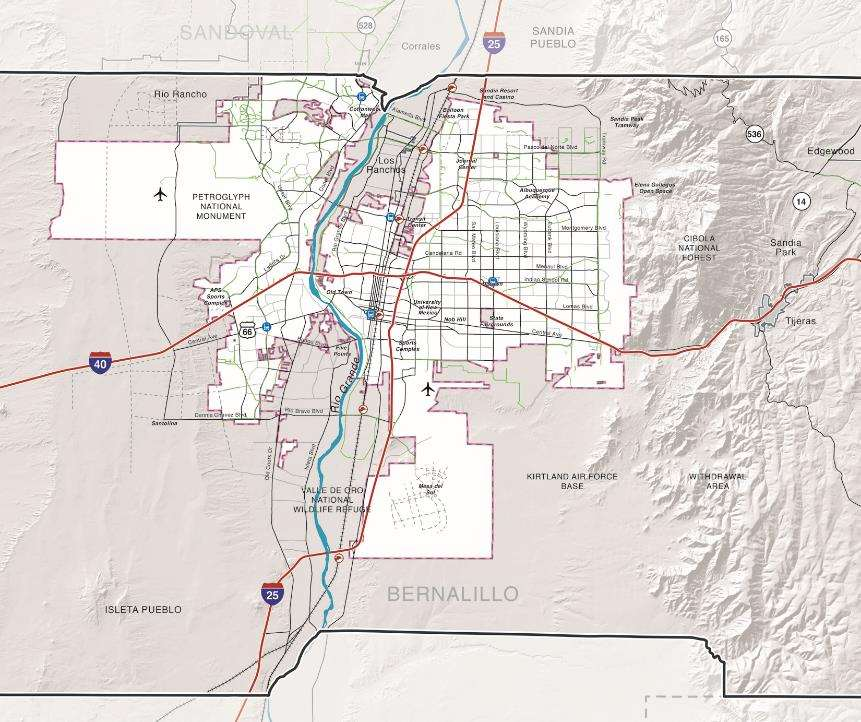
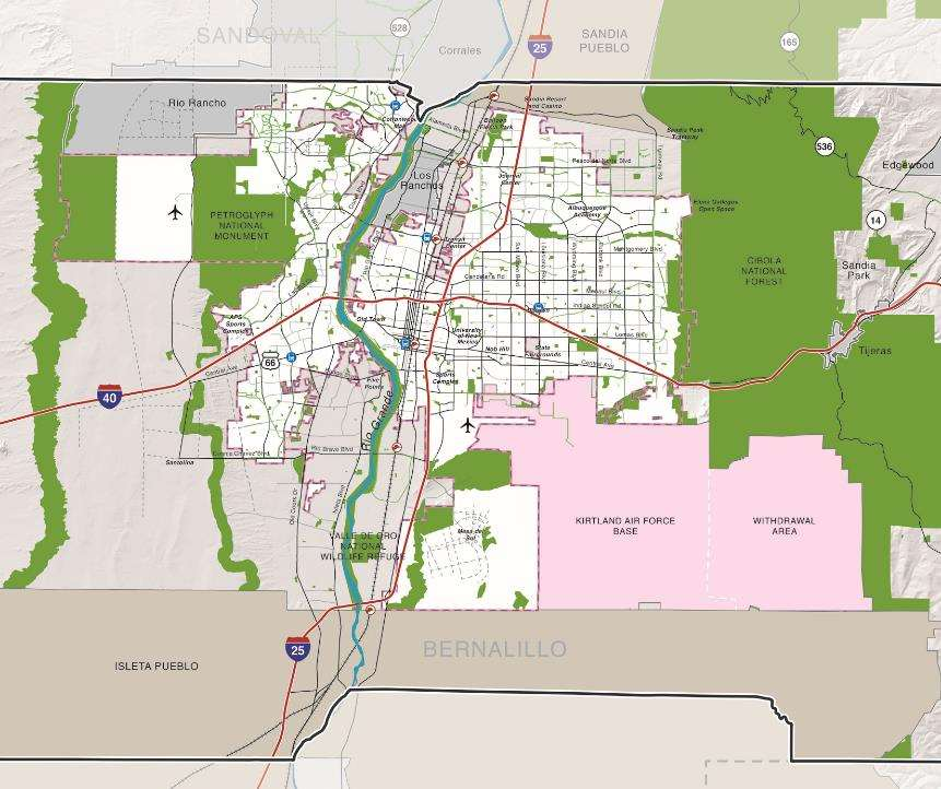
20 Open Space Network
21 Other Jurisdictions
22 Downtown
23 Urban Centers
24 Neighborhood Centers
25 Village Centers

26 Main Streets
27 Multi-Modal Corridors
28 Commuter Corridors
29 Premium Transit Corridors
30 Community Vision
31 Community Vision

32 Land Use: Areas of Change & Consistency Direct growth toward Areas of Change Preserve character in Areas of Consistency Image: Map of Areas of Consistency and Change

33 Areas of Change/Areas of Stability concept used in 5 other cities! Southern Oregon Tulsa, OK Athens, GA Lai e HI

34 Since Blueprint was adopted in 2002, Denver s most intense development activity has occurred within designated Areas of Change

35 Urban Design: Design Types Auto Oriented Pedestrian Oriented
36 Design Type Urban Design: Coordinating land use & transportation Activity Centers Corridors Village Urban Main Street Neighborhood Downtown Multi- Modal Transit Commuter 1 Rural 2 Suburban 3 General Urban 4 Centers & Main Streets 5 Urban Core
37 ABC Comp Plan Introduction & How-to Use Growth & Development Vision A People s Summary Comp Plan Elements Challenges / strategies Goals Policies Implementation [pending] 5-year strategic plan for City & County Long-term & medium-term actions Coordination with outside agencies and/or organizations
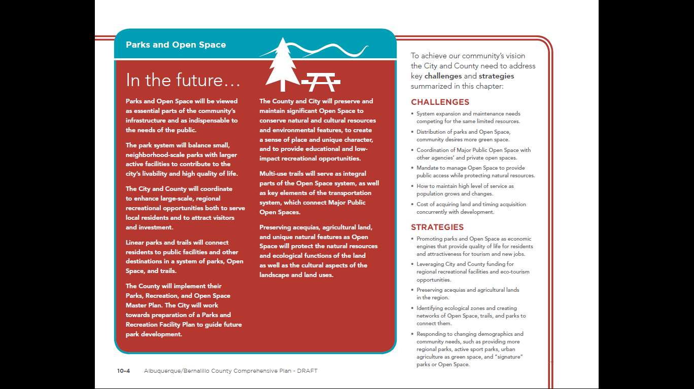
38 Comp Plan Elements 1. Neighborhoods 2. Land Use 3. Transportation 4. Urban Design 5. Economic Development 7. Parks & Open Space 8. Heritage Conservation 9. Resilience & Sustainability 10. Infrastructure, Community Facilities, & Services 6. Housing

39

40
41
42

43

44 Multiple layers of zoning tools Parcels Regulated only by Zoning Code 53% Parcels Regulated by SDP or Overlay Zone 47%

45 Special use zones: SU-1 Over 550 separate zones! 45
46 Conflicting and Overlapping Zoning Rank 1 Goals & Policies Rank 2 Area Plan Goals & Policies Rank 3 City Sector Plan Goals & Policies New Goals & Policies 46
47 What happens to SU-2 Zones? Base Zones Extends SU-2 zones to other areas with similar character SU-2 ZONES Charac ter Overlay Zone Citywide Standa rds Incentiv es Applies protections in unique areas Become citywide or areawide standards Achieves results not wisely/legally gained through zoning Deleted Removes outdated or unenforceable regulations 47

48 Module 1 2. Permitted Uses 40 SU2s with Zoning Many with 5-10 subareas = 235+ different zone districts (+550 SU1 districts) This table continues for 115 pages 48
49 Be Realistic Much SU2 content reflects good ideas that can be generalized Not all SU2 content should or will be included in the new IDO Dry goods not included. Provided any one of the following conditions are met: a. A minimum of 50% of the total acreage of premises along individual block faces and within the same block as the subject lot contains existing legal nonresidential uses; or b. The subject property contains a building that had a non-residential use for a minimum of 10 of the past 50 years; or c. The building on the subject property was originally built for commercial uses AND provided there is no outdoor storage or activity except parking.

50 The IDO Strategy IDO is drafted in 3 Modules 1. Zone Districts and Permitted/Conditional Uses 2. Development Standards 3. Administration and Procedures Then a Consolidated Draft to EPC for review

51 A Simpler Permitted Use Table Zone districts in 3 categories P C CA CV A T uses Land uses organized by type Use- Specific Standards 51
52 Consolidate the Use-Specific Standards Special standards that apply to a particular use that can regulate Scale Location Protection of adjacent land uses Etc. AND Can be tailored to specific locations if needed Example Veterinary Hospital In the MX-L and MX-M zone districts treatment of large animals, including but not limited to cattle, horses, sheep, goats, or pigs weighing over 100 pounds, is not allowed. Only treatment of dogs, cats, other domestic pets, and small animals is allowed. In the MX-M and NR-C zone districts outside exercise runs are permitted, provided they are enclosed with a solid wall or fence at least six feet high. Outside areas for occupancy by animals overnight are not permitted. 52
53 The Process Read the SU2s and identify use controls Module 1 Text Conversion Table and Map Make good general standards into Usespecific Standards for that use Identify the NEW zoning district most similar to the intended character of the area Save height, size, and other SU2 regulations for consideration in Modules 2 and 3 Do not carry over lotspecific, outdated, or unenforceable provisions Draft zone district conversion table (Done) and conversion map (In process) 53

54 Project Webpage: Questions? Manager Urban Design & Development Planning Dept Policy Analyst Council Services Long-range Planner Planning Dept Project Planner Bernalillo County Planning
INTRODUCTION TO ZONING DISTRICT REGULATIONS
 INTRODUCTION TO ZONING DISTRICT REGULATIONS Classification of Zoning Districts Zoning districts in Dorchester County are categorized as Suburban Urban, Suburban Transition, or Rural. These districts are
& Comprehensive Plan Updates
 Unified Development Ordinance & Comprehensive Plan Updates Mandatory Consultant Workshop Planning Department & Council Services August 26, 2014 What s working well Comp Plan Centers & Corridors Transportation
Community Planning Development Overview of Development and Entitlement Processes. April 20, 2015
 Community Planning Development Overview of Development and Entitlement Processes April 20, 2015 1 Overview 1. Introduction to Community Planning & Development 2. Citywide and Small Area Plans What they
FUTURE LAND USE ELEMENT
 GOALS, OBJECTIVES AND POLICIES FUTURE LAND USE ELEMENT GOAL A THE CITY OF FORT WALTON BEACH WILL PLAN FOR AND PROVIDE A HIGH QUALITY OF LIFE TO MEET THE NEEDS OF THE CURRENT AND FUTURE POPULATION, PROVIDING
Rapid City Downtown Area Master Plan. Draft Plan Concepts April 2016
 Rapid City Downtown Area Master Plan Draft Plan Concepts April 2016 CALL TO ACTION! A Thriving Downtown = Regional Economic Prosperity Rapid City is competing nationally for a limited supply of young skilled
ASPEN HILL Minor Master Plan Amendment
 ASPEN HILL Minor Master Plan Amendment Agenda Welcome and Introductions (6:30 PM) Staff Presentation (6:40-7:30 PM) Q&A (7:30-8:00 PM) Community Meeting #2 April 1, 2014 Aspen Hill Library Planning Process
Citizen Advisory Group Meeting #1 December 8, 2011 6:00 p.m.
 Citizen Advisory Group Meeting #1 December 8, 2011 6:00 p.m. Meeting Agenda 1. Background Information 2. Policy Framework 3. Plan Development Process 4. Public Input Results 5. Vision Statement 6. Group
Appendix J Santa Monica Travel Demand Forecasting Model Trip Generation Rates
 Appendix J Santa Monica Travel Demand Forecasting Model Trip Generation Rates SANTA MONICA TRAVEL DEMAND FORECASTING MODEL TRIP GENERATION RATES SUBMITTED BY: 201 Santa Monica Blvd., Suite 500 Santa Monica,
CITY COUNCIL / PLANNING COMMISSION JOINT STUDY SESSION AGENDA REPORT
 CITY COUNCIL / PLANNING COMMISSION JOINT STUDY SESSION AGENDA REPORT MEETING DATE: SEPTEMBER 8, 2015 ITEM NUMBER: 1 SUBJECT: PROPOSED GENERAL PLAN LAND USE ALTERNATIVE FOR THE YEAR 2015-2025 GENERAL PLAN
TOWN OF CARY CONDITIONAL USE ZONING PERMIT. 412 Rutherglen Cary, NC 27511-6437. 412 Rutherglen Cary, NC 27511-6437
 TOWN OF CARY CONDITIONAL USE ZONING PERMIT PETITION: PETITIONER(S): OWNER(S): LOCATION: 01-REZ-16 204 N. Dixon Avenue, Cary, NC PARCEL IDENTIFICATION: 076418218784 REALID: 0031004 AREA: APPROVED ZONING:
VANDERBILT COMPARISON
 Village of Vanderbilt Comparison One County, One Vision Master Plan (2000) 1 15 Improve recreation in Otsego County by assessing the availability and need to improve bike paths, county recreation facilities,
January 2015 BrowardNext Summary Survey Results for Focus Area Priorities. Ranking of Focus Area Importance
 January 2015 BrowardNext Summary Survey Results for Focus Area Priorities Ranking of Focus Area Priorities for the Broward County Land Use Plan The graphic below illustrates the survey results for Focus
KEYPORT COMMUNITY PLAN
 PLANNING COMMISSION TASKS Collect Public Comments on Draft Plan. Provide Clear Direction for: Preferred LAMIRD Boundary Lot Clustering Provision View Protection Recommendation to Board of County Commissioners.
Zoning Most Frequently Asked Questions
 Zoning Most Frequently Asked Questions Zoning is needed to achieve the following: Orderly development consistent with utility location/capacity, street network, public services; Compatible land uses in
Comprehensive Plan Update
 Comprehensive Plan Update Today s Agenda 1. Welcome and Presentation 2. Reality Check-Lite Exercise 3. Greenway Mapping Exercise 4. Priority Thought Wall Exercise 5. Next Steps Recap of Feb. Public Meetings
Attachment B Policy Audit Template
 Attachment B Policy Audit Template 5 6 7 8 9 0 Provide A Variety of Transportation Choices Provide A Variety of Transportation Choices Provide A Variety of Transportation Choices Encourage transit-oriented
Economic Development Element
 The Strawberry Ladies by Tara Stood Economic Development Element Economic development enhances San Clemente s quality of life by providing local goods and services and expanding employment and business
Cherokee County: Bells Ferry LCI Study & County Ordinance Audit. Prepared by Atlanta Regional Commission Staff 2006. Atlanta Regional Commission
 Cherokee County: Bells Ferry LCI Study & County Ordinance Audit Prepared by Atlanta Regional Commission Staff 2006 Atlanta Regional Commission 1 Document Review and Recommendations Introduction The objective
Opal Service District Plan
 8 The Opal Service District includes a variety of planned land uses including commercial, mixed-use, flex office, industrial, and hospitality. This Plan seeks to simplify the land use categories to allow
Downtown Core Sub-district
 3-10 Land Use Downtown Core Sub-district District development will be most intense and most urban in character in the Downtown Core. The objective is to establish this area as a citywide and regional retail
Near West Side Comprehensive Plan Executive Summary (Revised) April 2004 City of Milwaukee DCD
 April 2004 City of Milwaukee DCD") Near West Side Comprehensive Plan Executive Summary (Revised) April 2004 City of Milwaukee DCD Boundaries The Near West Side Comprehensive Plan covers a broad area immediately west of Milwaukee s downtown.
Near West Side Comprehensive Plan Executive Summary (Revised) April 2004 City of Milwaukee DCD Boundaries The Near West Side Comprehensive Plan covers a broad area immediately west of Milwaukee s downtown.
Industrial Suburban District Regulations City of St. Petersburg City Code Chapter 16, Land Development Regulations
 16.20.110 - Industrial Suburban District ( IS ) Figure REFERENCE Typical Buildings in the IS District Figure REFERENCE Site Plan of a typical development in the IS District Sections: 16.20.110.1 Composition
2010 Salida Community Priorities Survey Summary Results
 SURVEY BACKGROUND The 2010 Salida Community Priorities Survey was distributed in September in an effort to obtain feedback about the level of support for various priorities identified in the draft Comprehensive
Land Use and Zoning. Land Use Within the Port Madison Indian Reservation
 Land Use and Zoning Land Use Within the Port Madison Indian Reservation A portion of the Suquamish Rural Village is Trust land, owned either by the Tribe or individual tribal members. The following list
Transportation Breakout Session. Curvie Hawkins Mark Rauscher Mike Sims Paul Moore
 Transportation Breakout Session Curvie Hawkins Mark Rauscher Mike Sims Paul Moore Curvie Hawkins Director of Planning Fort Worth Transportation Authority Fort Worth Transportation Authority The T Presented
City of North Miami Beach, Florida Planning and Zoning Department
 City of North Miami Beach, Florida Planning and Zoning Department City Council Staff Report TO: FROM: City Council Carlos Rivero, City Planner DATE: March 17, 2015 ITEM: 14-021B (Ordinance no. 2015-5)
Public Worksessions - A Summary of the New York City Zoning and Planning Study
 APPENDIX F Third Public Work Session Notice Presentation July 27, 2004 For Immediate Release July 12, 2004 Town of Rotterdam Notice of Public Meeting The Town of Rotterdam Public Works Department will
Comprehensive Plan Policies that support Infill and Mixed Use
 Comprehensive Plan Policies that support Infill and Mixed Use Introduction A comprehensive plan provides a broad vision for the future growth of a community. It is often formulated using community visioning
01/31/13 ACHIEVING THE VISION FOR RESTON. Reston Master Plan Special Study Task Force
 ACHIEVING THE VISION FOR RESTON Reston Master Plan Special Study Task Force The Reston Master Plan Special Study Task Force was appointed by Hunter Mill District Supervisor Catherine Hudgins to review
Prepared by: Samuel Dennis Date prepared: December 21, 2011
 Hillsborough County City-County Planning Commission EXECUTIVE SUMMARY Meeting Date: Agenda Item: January 9, 2012 - Planning Commission Public Hearing Tampa: Text Amendment to Public/Semi-Public Land Use
South LA Fast Food Health Impact Assessment
 South LA Fast Food Health Impact Assessment Draft April 3, 2013 EXECUTIVE SUMMARY PURPOSE Decades of research indicate that an individual s health is not solely impacted by their biological predisposition
Performance Measures for a Sustainable Transportation Network Pasadena s Approach Frederick C. Dock, Ellen Greenberg, Mark Yamarone
 Performance Measures for a Sustainable Transportation Network Pasadena s Approach Frederick C. Dock, Ellen Greenberg, Mark Yamarone Abstract. As California cities move into the second decade of the 21st
City of Tampa Zoning Districts
 City of Tampa Zoning Districts The city is divided by chapter 2 into zoning districts, the boundaries and designations of which are shown in a series of maps, covering in combination the entire land and
7 December 10, 2014 Public Hearing APPLICANT: OBEDIENT PAWS, L.L.C.
 7 December 10, 2014 Public Hearing APPLICANT: OBEDIENT PAWS, L.L.C. PROPERTY OWNER: DIANE BLACKISTON STAFF PLANNER: Graham Owen REQUEST: Conditional Use Permit (Home Occupation) ADDRESS / DESCRIPTION:
DRAFT Policy to Guide Discretion on Proposed Relaxations to Minimum Parking Requirements in Commercial Districts City-Wide 2014 June 05
 PARKING INITIATIVES Attachment I Corridor Program Descriptions Corridor Program Pilot Though the Corridor Program will officially launch in the fall, this summer, The City will pilot the first phase of
Los Angeles Union Station, CA Sustainable Neighborhood Assessment. April 22-23, 2014
 Los Angeles Union Station, CA Sustainable Neighborhood Assessment April 22-23, 2014 Sustainable Neighborhood Assessment Through the Sustainable Neighborhood Assessment Tool developed by Global future development
COUNTY OF ALBEMARLE PLANNING STAFF REPORT SUMMARY. Staff: Claudette Grant
 COUNTY OF ALBEMARLE PLANNING STAFF REPORT SUMMARY Project Name: ZMA 2013-00004 Hollymead Town Center Block VI Planning Commission Public Hearing: July 29, 2014 Staff: Claudette Grant Board of Supervisors
Rezoning case no. RZ15-08: Adam Development Properties, LP
 PLANNING AND ZONING COMMISSION STAFF REPORT June 4, 2015 Rezoning case no. RZ15-08: Adam Development Properties, LP CASE DESCRIPTION: LOCATION: a request to amend the development plan of a previously-approved
STRATEGIC PLAN 2015 2020 2030
 STRATEGIC PLAN 2015 2020 2030 Boca Raton, Florida May 2015 Lyle Sumek Associates, Inc. Phone: (386) 246-6250 9 Flagship Court Fax: (386) 246-6252 Palm Coast, FL 32137 E-mail: sumekassoc@gmail.com Table
Planning Commission Staff Report
 10 Planning Commission Staff Report TO: FROM: THROUGH: PLANNING COMMISSION AMY TEMES, SENIOR PLANNER (480) 503-6729, AMY.TEMES@GILBERTAZ.GOV CATHERINE LORBEER, AICP, PRINCIPAL PLANNER (480) 503-6016 CATHERINE.LORBEER@GILBERTAZ.GOV
Chapter 9: Transportation
 Chapter 9: Transportation What is this chapter about? The goals and policies in this chapter convey the City s intent to: Create a coordinated, efficient, and more affordable multimodal transportation
Corridor Goals and Objectives
 Corridor Goals and Objectives This chapter presents the goals and objectives, developed by the Corridor Study Committee, that serve as the purpose and intent of the Corridor Plan. This plan covers a twenty
Borough of Glassboro, New Jersey May 2010. Redevelopment Plan for Rehabilitation In the Borough of Glassboro May 2010
 Borough of Glassboro, New Jersey May 2010 Redevelopment Plan for Rehabilitation In the Borough of Glassboro May 2010 Table of Contents Page Number I. Introduction 3 II. Designation of Area and Plan Development
Model Subdivision and Land Development (SALDO) Subdivision/ Land Development Presentation Overview. Why Subdivision and Land Development Regulations?
 Subdivision/ Land Development Presentation Overview. Why Subdivision and Land Development Regulations?") Model Subdivision and Land Development (SALDO) Subdivision/ Land Development Presentation Overview Purpose of Subdivision/ Land Development Ordinances (SALDO) Municipalities Planning Code Process Design
Model Subdivision and Land Development (SALDO) Subdivision/ Land Development Presentation Overview Purpose of Subdivision/ Land Development Ordinances (SALDO) Municipalities Planning Code Process Design
1. Land Use. Chapter 1: Land Use 1-1 Adopted 10/2/09 Amended 3/22/11, 8/16/11
 1. Land Use Minneapolis will develop and maintain a land use pattern that strengthens the vitality, quality and urban character of its downtown core, commercial corridors, industrial areas, and neighborhoods
Public Hearing. City Council Study Session. February 11, 2013
 Public Hearing City Council Study Session February 11, 2013 1 Staff Report Summarize the Overlay Conduct Public Hearing Council Discussion Schedule and Next Steps 2 2012-13 2007-2008 2013-2014 2013-2014
28.0 Development Permit Area #2 (Neighbourhood District)
") 28.0 Development Permit Area #2 (Neighbourhood District) Goals and Objectives To provide a guide for infill and new development in the Neighbourhood District. To outline the nature, form and character
28.0 Development Permit Area #2 (Neighbourhood District) Goals and Objectives To provide a guide for infill and new development in the Neighbourhood District. To outline the nature, form and character
Community Development Overview
 Community Development Overview Citizen s Planning Academy Presented on March 2, 2016 Planning/Smart Growth Overview Brief History of Planning/Urban Form Smart Growth SACOG Blueprint General Plan Update
Land Use Element. Introduction 2.3. A Citywide Land Use Policies 2.3. A-1 The Future Land Use Map & the Location of Zones 2.3. A-2 Uses 2.
 Seattle s Comprehensive Plan Toward a Sustainable Seattle 2.1 Land Use Element Table of Contents Introduction 2.3 A Citywide Land Use Policies 2.3 A-1 The Future Land Use Map & the Location of Zones 2.3
NYE COUNTY, NV PAHRUMP REGIONAL PLANNING COMMISSION REGULAR MEETING JANUARY 15, 2014
 NYE COUNTY, NV PAHRUMP REGIONAL PLANNING COMMISSION REGULAR MEETING JANUARY 15, 2014 Staff Report Agenda Item No. 11 CASE DESCRIPTION(S): LOCATION: APPLICANT(S): For possible action - Bill No. 2014-01:
Boston Way Site & Springwood Avenue Corridor. Vision Plan Second Public Forum
 Boston Way Site & Springwood Avenue Corridor Vision Plan Second Public Forum 1 Team Renaissance Equity Partners LLC Netta Architects Phillips Preiss, Grygiel, LLC Milestone Development LLC Maestro Community
APPLICABILITY OF LEED FOR COLLEGES AND UNIVERSITIES
 APPLICABILITY OF LEED FOR COLLEGES AND UNIVERSITIES Colleges and universities are prime candidates for many of the LEED rating systems. Stable institutions do well to plan for the long term. This involves
Minor Accommodation Planning Review Application
 City of Beverly Hills Planning Division 455 N. Rexford Drive Beverly Hills, CA 90210 Tel. (310) 285 1141 Fax. (310) 858 5966 Planning Review Overview: Minor Accommodation Planning Review Application Before
SACRAMENTO COUNTY SUMMARY OF ZONING CLASSIFICATIONS
 SACRAMENTO COUNTY SUMMARY OF ZONING CLASSIFICATIONS This document provides a brief overview of zoning designations only. Inaccuracies may be present. Please consult the Sacramento County Zoning Code for
Restoration. a brief look at
 Copyright 2009 Canin Associates, Inc. All rights reserved. No part of this publication may be reproduced or transmitted by any means without written permission from Canin Associates, Inc. a brief look
Scenario Planning Report. Austin South Shore Central
 View of Downtown Austin from South Shore s Statesman site. Introduction Austin s South Shore Central Sub-District South Shore Central is an 88-acre sub-district of the waterfront overlay. As a fairly auto-oriented
HARRIS TEETER AT LADY S ISLAND CITY OF BEAUFORT DRB CONCEPTUAL PROJECT NARRATIVE Submittal Date: September 2, 2015 Meeting Date: September 10, 2015
 HARRIS TEETER AT LADY S ISLAND CITY OF BEAUFORT DRB CONCEPTUAL PROJECT NARRATIVE Submittal Date: September 2, 2015 Meeting Date: September 10, 2015 PROPOSED REDEVELOPMENT The project consists of demolishing
Chapter 13: Implementation Plan
 Chapter 13: 13.1. INTRODUCTION The purpose of the implementation chapter of the Comprehensive Plan is to set forth the actions that the City will take to ensure that the plans, programs and policies set
VISION, DESIGN PRINCIPLES & OVERALL PLANNING STRATEGY
 3 VISION, DESIGN PRINCIPLES & OVERALL PLANNING STRATEGY The overall planning strategy for the Bank Street CDP is to ensure that future development is undertaken in a coordinated and planned approach, supported
7.0 GOALS, OBJECTIVES & POLICIES
 7.0 GOALS, OBJECTIVES & POLICIES The following Goals, Objectives and Policies specific to Housing are organized into broad categories including: 7.1: Housing Availability 7.2: Protection of Existing Neighborhoods
CUSTOMER INFORMATION BULLETIN
 DEPARTMENT OF COMMUNITY AND ECONOMIC DEVELOPMENT Attachment A CUSTOMER INFORMATION BULLETIN REQUIREMENTS FOR KEEPING PETS AND OTHER ANIMALS 1055 South Grady Way-Renton, WA 98057 Phone: 425-430-7200 (then
Atlanta Regional Commission s Lifelong Communities Initiative: Creating Communities for All Ages and Abilities
 Atlanta Regional Commission s Lifelong Communities Initiative: Creating Communities for All Ages and Abilities Laura Keyes, MS, AICP and Cathie Berger, LMSW The Atlanta region is experiencing a monumental
NOTICE OF PREPARATION
 PLANNING DIVISION CITY OF SUNNYVALE P.O. BOX 3707 SUNNYVALE, CA 94088-3707 NOTICE OF PREPARATION TO: Responsible, Trustee, and Other Interested Public Agencies FROM: Sunnyvale Community Development 456
BASSETT CREEK VALLEY MASTER PLAN OPEN HOUSE
 BASSETT CREEK VALLEY MASTER PLAN OPEN HOUSE February 23, 2006 PROJECT INTRODUCTION Project Area 230 acres $50 million estimated market value (approximately) 50 acres parkland 100 residences (estimated)
Appendix C Related Studies
 Appendix C Related Studies Intermodal Transit Village Concept Plan Appendix C Related Studies This appendix summarizes studies that are current at the time of this Plan. Intermodal Transit Village Concept
Smart Growth and Airport Vicinity Planning
 Smart Growth and Airport Vicinity Planning APA National Conference, Los Angeles, April 2012 Mark Johnson, AICP, Ricondo & Associates, Inc. Ben Herman, FAICP, Clarion Associates, LLC Michael Armstrong,
Mid-Coast Corridor Transit Project San Diego, California New Starts Project Development (Rating Assigned November 2014)
") Mid-Coast Corridor Transit Project San Diego, California New Starts Project Development (Rating Assigned November 2014) Summary Description Proposed Project: Light Rail Transit 10.9 Miles, 9 Stations Total
Mid-Coast Corridor Transit Project San Diego, California New Starts Project Development (Rating Assigned November 2014) Summary Description Proposed Project: Light Rail Transit 10.9 Miles, 9 Stations Total
ANNUAL ELEMENT PROGRESS REPORT Housing Element Implementation (CCR Title 25 6202 )
") page 1 of 9 (CCR Title 5 6 ) Reporting Period 7-1 Table A Annual Building Activity Report Summary - New Construction Very Low-, Low-, and Mixed- Multifamily Projects Housing Development Information Housing
page 1 of 9 (CCR Title 5 6 ) Reporting Period 7-1 Table A Annual Building Activity Report Summary - New Construction Very Low-, Low-, and Mixed- Multifamily Projects Housing Development Information Housing
Revere Beach Transit-Oriented Development Parcels Revere, Massachusetts. Design and Development Guidelines. Part Two.
 Revere Beach Transit-Oriented Development Parcels Revere, Massachusetts Design and Development Guidelines Request for Qualifications and Expressions of Interest with Preliminary Development Plans Part
METROPOLITAN REDEVELOPMENT PLAN II OLD ALBUQUERQUE HIGH SCHOOL
 METROPOLITAN REDEVELOPMENT PLAN II OLD ALBUQUERQUE HIGH SCHOOL Preface This revised plan for redevelopment of the Old Albuquerque High School Metropolitan Redevelopment Area has been prepared pursuant
AVALON PARK WEST (FORMERLY NEW RIVER) PD/MPUD- NARRATIVE FOR DRI RESCISSION, PD SUBAREA AMENDMENT AND MPUD SUBSTANTIAL MODIFICATION.
 PD/MPUD- NARRATIVE FOR DRI RESCISSION, PD SUBAREA AMENDMENT AND MPUD SUBSTANTIAL MODIFICATION.") AVALON PARK WEST (FORMERLY NEW RIVER) PD/MPUD- NARRATIVE FOR DRI RESCISSION, PD SUBAREA AMENDMENT AND MPUD SUBSTANTIAL MODIFICATION DRI Rescission On January 7, 1992, the Pasco County Board of County Commissioners
AVALON PARK WEST (FORMERLY NEW RIVER) PD/MPUD- NARRATIVE FOR DRI RESCISSION, PD SUBAREA AMENDMENT AND MPUD SUBSTANTIAL MODIFICATION DRI Rescission On January 7, 1992, the Pasco County Board of County Commissioners
COMMUNITY WORKSHOP #2
 COMMUNITY WORKSHOP #2 General Plan Elements Update April 28, 2015 Today s Agenda I. Project Purpose What Are We Doing and Why! II. What is a General Plan? III. Project Overview/Timeline IV. Community Input
Mid-Coast Corridor Transit Project San Diego, California New Starts Engineering (Rating Assigned November 2015)
") Mid-Coast Corridor Transit Project San Diego, California New Starts Engineering (Rating Assigned November 2015) Summary Description Proposed Project: Light Rail Transit 10.9 Miles, 9 Stations Total Capital
Mid-Coast Corridor Transit Project San Diego, California New Starts Engineering (Rating Assigned November 2015) Summary Description Proposed Project: Light Rail Transit 10.9 Miles, 9 Stations Total Capital
Churches and Schools Development Standards
 Uses Code Provisions Site Development Standards RS-4 Sec.24-44 RD Sec. 24-45 RM-23 Sec. 24-48 Residential Single Family Residential Two- Family (Duplex) Residential Mid- Rise Multifamily (High Density)
Draft Goals and Objectives Wadena Comprehensive Plan City of Wadena, Minnesota. Land Use Goals:
 Draft Goals and Objectives Wadena Comprehensive Plan City of Wadena, Minnesota Land Use Goals: 1. Growth in Wadena will be undertaken in such a manner as to create a full range of living, working, shopping,
Planning for the future. building a great city, great neighbourhoods
 Planning for the future building a great city, great neighbourhoods Table of contents 1 Looking ahead 2.4 million Calgarians 2 Goals 3 Building a sustainable, connected city of great neighbourhoods 4 Finding
Seattle Streetcar Center City Connector Seattle, Washington Small Starts Project Development (Rating Assigned November 2015)
") Seattle Streetcar Center City Connector Seattle, Washington Small Starts Project Development (Rating Assigned November 2015) Summary Description Proposed Project: Streetcar 1.3 Miles, 4 Stations otal Capital
Seattle Streetcar Center City Connector Seattle, Washington Small Starts Project Development (Rating Assigned November 2015) Summary Description Proposed Project: Streetcar 1.3 Miles, 4 Stations otal Capital
TABLE OF CONTENTS. INTRODUCTION...1 Purpose of a Comprehensive Plan...1 McKenzie County Comprehensive Plan...1 Definitions...2 Goal...2 Vision...
 MCKENZIE COUNTY COMPREHENSIVE PLAN TABLE OF CONTENTS INTRODUCTION...1 Purpose of a Comprehensive Plan...1 McKenzie County Comprehensive Plan...1 Definitions...2 Goal....2 Vision...3 ECONOMIC DEVELOPMENT...4
Envision Venice Strategic Plan for Fiscal Year Ending. September 30, 2016. Preserving and Enhancing the Venice Quality of Life.
 Adopted April 28, 2015 October 1, 2015 through September 30, 2016 Envision Venice Strategic Plan for Fiscal Year Ending September 30, 2016 Preserving and Enhancing the Venice Quality of Life Table of Contents
Appendix N: Bicycle Parking Ordinance
 Appendix N: Bicycle Parking Ordinance ORDINANCE NO. #1-13. AN ORDINANCE AMENDING CHAPTER 40 OF THE MUNICIPAL CODE OF THE CITY OF DAVIS TO ADD ARTICLE 40.25A ESTABLISHING BICYCLE PARKING STANDARDS WHEREAS,
WESTFIELD-WASHINGTON ADVISORY PLAN COMMISSION December 7, 2015 1512-SPP-24 & 1512-ODP-24
 Petition Number: Subject Site Address: Petitioner: Request: East side of Oak Road, north of 151 st Street Langston Development Co. Primary Plat and Overall Development Plan amendment review for Mapleridge
2013 2015 COMPREHENSIVE PLAN UPDATE CITY COUNCIL ADOPTION DECEMBER 8, 2015
 2013 2015 COMPREHENSIVE PLAN UPDATE CITY COUNCIL ADOPTION DECEMBER 8, 2015 COMPREHENSIVE PLAN UPDATE OVERVIEW Deliberate and make a motion after each ordinance discussion in this order: 1. Ordinance O-4506:
Zoning Districts, Gwinnett County, Georgia
 Zoning Districts, Gwinnett County, Georgia The zoning district descriptions in this section should be used as a guide only for the unincorporated areas of Gwinnett County. Before buying or selling property,
Eagle Commuter Rail Denver, Colorado Final Design (Based upon information received by FTA in November 2010)
") Eagle Commuter Rail Denver, Colorado Final Design (Based upon information received by FTA in November 2010) Summary Description Proposed Project: Electrified Commuter Rail 30.2 Miles, 13 Stations Total
Eagle Commuter Rail Denver, Colorado Final Design (Based upon information received by FTA in November 2010) Summary Description Proposed Project: Electrified Commuter Rail 30.2 Miles, 13 Stations Total
Smart Growth Illustrated: Developer s Guidebook. City of Bentonville Community Development Department October 2006
 Smart Growth Illustrated: Developer s Guidebook City of Bentonville Community Development Department October 2006 1 Table of Contents What is Smart Growth...3 Six Goals of Smart Growth 5 Ten Tools of Smart
Kendell Keith, RLA, AICP, LEED AP Executive Vice President RELEVANT EXPERIENCE
 EDUCATION Master of Business Administration, Rollins College, Winter Park, Florida (2006) Master of City Planning, Georgia Institute of Technology, Atlanta, Georgia (1991) Graduate Certificate in Real
# U N I V E R S I T Y A V E N U E S P E C I F I C P L A N Page 1-1 # 1.0 INTRODUCTION. 1.1 University Avenue, Historical Context
 1.0 INTRODUCTION 1.1 University Avenue, Historical Context By the late 1880s, the role of University Avenue, then known as Eighth Street, was already well established as a link between the original Riverside
Strategic Planning. Frequently Asked Questions. Member Services
 The SID is proactively working to combat these challenges and is poised to take the necessary steps to ensure downtown transitions from these difficult times to a vibrant and active center Strategic Planning
TABLE OF CONTENTS. Executive Summary 1-3. Introduction 4-6. Illustrative Site Plan 7. East-West Streets 8. Cooper Street 9-10. Market Street 11-14
 TABLE OF CONTENTS Executive Summary 1-3 Introduction 4-6 Illustrative Site Plan 7 East-West Streets 8 Cooper Street 9-10 Market Street 11-14 Federal Street 15-16 MLK Boulevard 17-20 North-South Streets
Comprehensive Plan Amendment
 Staff Report CP-2-16 Comprehensive Plan Amendment Staff recommends four changes to the Economic Development element of the 2030 Comprehensive Plan to reflect a new Economic Development Toolkit and new
SAN DIEGO MIXED USE URBAN VILLAGES: KEY ZONING CODE ISSUES AND OPTIONS
 ` SAN DIEGO MIXED USE URBAN VILLAGES: KEY Public Discussion Draft / September 2014 Clarion Associates 621 17 th Street, Suite 2250 Denver, CO 80293 303 830 2890 In association with Smart Growth America
IMPLEMENTATION STRATEGIES The following sections list the implementation strategies for following chapters.
 CHAPTER 13: IMPLEMENTATION INTRODUCTION The purpose of the Implementation Chapter is to set forth the actions that the City will take to ensure that the plans, programs, and policies set forth in the plan
ARTICLE 10.00 C-1 COMMERCIAL ZONE
 ARTICLE 10.00 C-1 COMMERCIAL ZONE 10.01 PURPOSE The Commercial Zone is intended to provide for the broad range of commercial operations and services required for the proper and convenient functioning of
Michigan State University Ingham County Health Department Tri- County Regional Planning Commission Land Use and Health Resource Team
 HEALTH IMPACT ASSESSMENT OF THE URBAN AND RURAL SERVICES MANAGEMENT POLICY Mid- Michigan Region Health In All Project Michigan State University Ingham County Health Department Tri- County Regional Planning
DIVISION STREET CORRIDOR STRATEGY Arlington, Texas May 17, 2012
 DIVISION STREET CORRIDOR STRATEGY Arlington, Texas May 17, 2012 Project Review: DCAC Meeting #2 March 8, 2012 Reviewed stakeholder meetings Online survey findings Market Assessment Macro Market Factors,
Implementing Plans Through Public / Private Partnerships
 Implementing Plans Through Public / Private Partnerships WAPA / WASLA 2006 Spring Conference Mark A. Olinger Department of Planning & Development City of Madison April 7, 2006 Outline Planning s s Role
Revitalizing. Tulsa.
 Revitalizing Tulsa. The Tribune Lofts Fabulous luxury apartment living in the inner-city. Community. Commerce. Lifestyle. Tulsa Development Authority Improving the quality of life while preserving neighborhoods.
21.04 LAND USE. Managing amenity through land use strategies
 21.04 LAND USE This section contains objectives and strategies for land use, under the themes of: Housing and community Retail, entertainment and the arts Office and commercial use Industry Education and
Staff Report. Approval beginning on Page 21. NW and Los Volcanes Road NW Size
 Environmental Planning Commission Agenda Number: 06 ProjectNumber: 1003478 Case #: 14EPC-40067 and 68 Nove mber, 13, 2014 Staff Report Agent Consensus Planning Staff Recommendation Applicant Curb Inc APPROVAL
Task 1 Project Management and Project Organization Work Plan
 City of Palmdale Active Transportation Program Plan Scope of Work At their January 22, 2015 meeting, the California Transportation Commission (CTC) allocated funding for the above-referenced project as