Where did AIS come from? The concept of a transponder for ships has been discussed in various forums since the 1980 s. The initial concept from the
|
|
|
- Edward Barker
- 7 years ago
- Views:
Transcription
1 1
2 2

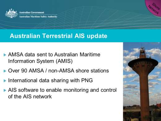
3 Where did AIS come from? The concept of a transponder for ships has been discussed in various forums since the 1980 s. The initial concept from the maritime sides was to have a means of positively identifying vessels within a VTS similar to the aviation squawking concept. There is a bit of a history with the introduction of the tool we have today AIS and it is important to understand the development process when looking at how the various international organizations have been working to fully develop the system. IMO and IALA have noted that AIS shall not only be effective in a ship to ship mode, but also work with shore infrastructure. ITU b) that the use of a universal shipborne AIS allows efficient exchange of navigational data between ships and between ships and shore stations, thereby improving safety of navigation; c) that a system using self-organized time division multiple access (SOTDMA) accommodates all users and meets the likely future requirements for efficient use of the spectrum; d) that although this system is intended to be used primarily for 4
4 surveillance and safety of navigation purposes in ship to ship use, ship reporting and vessel traffic services (VTS) applications, it may also be used for other maritime safety related communications, provided that the primary functions are not impaired; e) that this system is autonomous, automatic, continuous and operate primarily in a broadcast, but also in an assigned and in an interrogation mode using time division multiple access (TDMA) techniques; f) that this system is capable of expansion to accommodate future expansion in the number of users and diversification of applications, including vessels which are not subject to IMO AIS carriage requirements, aids to navigation and search and rescue; g) that IALA maintains and publishes technical guidelines for the manufacturers of AIS and other interested parties, 4

5 Where did AIS come from? IMO and IALA have noted that AIS shall not only be effective in a ship to ship mode, but also work with shore infrastructure. 5
 is a Very High Frequency (VHF) radio broadcasting system that transfers packets of data over the VHF data link (VDL) and enables AIS equipped")
6 How does AIS work? Put simply, the Automatic Identification System (AIS) is a Very High Frequency (VHF) radio broadcasting system that transfers packets of data over the VHF data link (VDL) and enables AIS equipped vessels and shore-based stations to send and receive identification information that can be displayed on a computer or chart plotter. Especially when used with appropriate graphical displays, this information can help in situational awareness and provide a means to assist in collision avoidance. In addition, AIS can be used as an aid to navigation, by providing location and additional information on buoys and lights. AIS uses a time-division multiple access (TDMA) scheme to share the VHF frequency, also known as the VHF Data Link (VDL). The VDL is divided into 2250 time slots that are repeated every 60 seconds and each AIS vessel in range sends a report to one of the time slots. At the same time, every AIS vessel in range is listening to all the timeslots and can read the reported information. Although Class A and Class B both use TDMA, they are different. Essentially, Class A units use transmissions that are self-organized into existing free slots whereas Class B units listen to the traffic to determine free slots and will make a one-off decision as to when it will transmit a report. Class B is designed with a 'politeness' factor, 6
7 meaning that it will not interfere or cause degradation of the ability of Class A units. There are many different uses for AIS as well. 6
 for vessels of 300 gross tonnage and upwards engaged on international voyages, cargo")
8 What are the types of AIS? AIS Class A is a shipborne mobile AIS unit and has been mandated by the International Maritime Organisation (IMO) for vessels of 300 gross tonnage and upwards engaged on international voyages, cargo ships of 500 gross tonnage and upwards not engaged on international voyages, as well as passenger ships, irrespective of size. AIS Class B is also a shipborne mobile AIS unit, but is not mandated by the International Maritime Organisation (IMO) and has been developed for vessels such as work craft and pleasure craft. AIS on SAR Aircraft Search and Rescue Aircraft may use AIS to assist in their operations. AIS Base Station are non-shipborne units, and are provided by a national competent authority to enable the ship to shore / shore to ship transmission of information. Networked AIS Base Stations can assist in providing overall maritime domain awareness. AIS AtoN provide an opportunity to transmit position and status of buoys and lights through the same VHF AIS process, which can then show up on the electronic chart or computer display. In addition, virtual aids to navigation can be transmitted by AIS, providing additional information where a buoy does not physically exist. AIS SART - Search and Rescue Transmitters using AIS can be used to assist in determining the final locating of a vessel or life raft, as part of the Global Maritime Distress and Safety System (GMDSS). 7

9 Image that demonstrates how some of the various units work together on the same VHF frequency the VHF data link or VDL 8

10 Different ways AIS data is displayed on the ship 9
11 10

12 Click on the logo upper left to activate the movie terrestrial AIS 11

13 12

14 Split room in two have one side all say their first names at the same time, get the other side to distinguish individual names; repeat for other side. AIS Satellite is a bit like trying to listen to everyone speak at the same time, and make sense out of it! Bjorn Narheim studies / Narheim wall data packet collisions 13
15 14

16 Note data available from AMSA website historic AIS data 15
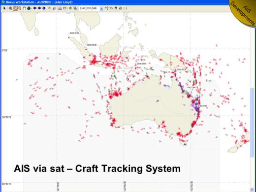
 environments; identify any limits and benefits of AIS via")
17 The trial on Satellite AIS goals were to: verify ability of AIS via Satellite to extend beyond terrestrial AIS; compare AIS via satellite data with other vessel track data fields to verify accuracy and reliability of the data; verify data format to enable AIS via satellite data to be viewed in both real time and historic (replay) environments; identify any limits and benefits of AIS via satellite in terms of units received (AIS Class A / Class B); area of coverage, refresh rates, logging and storage Did we meet our objectives? We did verify the ability of Sat AIS in the Australian context We did verify that the data was available in real time and for historic analysis (just like any AIS data) All data is being received as expected, but sometimes the lower power units (1W) do not allow every message to be received. 16

18 17
 trying to pick the right vessel to board")
19 Use on pilot boarding helicopters note the number of vessels off Hay Point (movie) trying to pick the right vessel to board 18

20 Note limitations with the trial in WA (headland) and success of trial in Newcastle. Longer ranges seem to limit usefulness. Ongoing work. 19
. AIS has now made it into MOB units which are available for sale through e- bay.")
21 MOB units have been developing, with initial work done on a VHF-DSC MOB. Australia developed a national testing standard for these units (AS/NZS MSLS other than MHz published Feb ). AIS has now made it into MOB units which are available for sale through e- bay. Kannad Safelink R10 SRS Personal AIS beacon Weatherdock easy rescue AIS SART beacon 20

22 Divers can sometimes go missing from large dive groups, or they may be fatigue or have an issue when they surface. An AIS SART like device has been developed to assist divers one that is good to 50m. MucMurdo AIS Smartfind S10 AIS beacon These are not on the two main AIS fequencies, but are being trialled on alternative frequency (160.9) 21
 like cars. There are significant safety issues each year, with a number of SAR incidents.")
23 In the Torres Strait there is a safety case for small format class Bs that are completely self contained, battery powered and suitable to put in a grab bag. In the area the Torres Strait Islanders travel between islands, using small tinnies (aliminum runabouts) like cars. There are significant safety issues each year, with a number of SAR incidents. As part of a focus effort to improve safety, a number of 406 MHz beacons have been supplied, and a concept of a grab bag is being developed. This grab bag would be available from local grocery stores or Ranger Stations, with a deposit, and would contain safety gear including life jackets; beacons; flares; etc. In addition, the small Class B would be included in the grab bag activated when it goes in so that it is transmitting. The Islander would pick up the grab bag before leaving, then drop it off at the next island (and get the deposit back). The class B would then go back on charge. 22

24 There are a number of issues that Australia is dealing with these are just a few to help promote discussion. As we can see these are units that can be bought on e-bay now so the equipment standard issue may already be too late. The success of AIS means that the key aspect safety of nav may get lost in the noise 23

25 Development of the VHF data exchange system VDES taking the capability of AIS and moving to develop on new frequencies We have a golden opportunity to revolutionize maritime communications At the World Radio Conference 2012, six channels were made available internationally for digital systems, with more available in some regions. The ITU has now laid the groundwork for the use of digitally modulated emissions in the maritime frequency bands - the challenge to the maritime community now is to use this resource effectively. We now have a chance to make the very best of what we have However we can t really change the spectrum it is what it is - a finite resource - and the spectrum will behave in the same way and give the same results pretty much each time you use it (within parameters ) With the development of software defined radio we can begin to look at combining spectrum providing for a wide band of spectrum for data transfer (i.e. taking 25 khz channels and combining to have 50 khz, 100kHz, even 150 khz) So, with the opportunity provided at WRC2012 we can contemplate the development of digital data transfer over these frequencies the development of the VHF data exchange system. In essence, we need to determine how to make the existing spectrum work smarter 24
 I ll have to make use of a great you tube video from the show QI If you take a laser pointer.")
26 It is difficult to see radio waves, so I'd like to show a bit of a demonstration with light waves. Since I wasn t able to source the correct materials (namely a green laser pointer ) I ll have to make use of a great you tube video from the show QI If you take a laser pointer... And point it at a white balloon. Nothing happens... Just goes a pretty shade of green. Can you adjust the parameters so that the white balloon so that the laser will 'pop' the balloon? Any ideas? (or have any of you seen the show??) Well, if we change a parameter - in this case, put a black dot on the balloon once again position the laser pointer the balloon goes pop! 25

27 If we use the radio spectrum made available at WRC2012 in the VHF maritime mobile band, and change some parameters - we could develop a digital data transmission system for VHF radio that would enable greater amounts of data to be communicated at higher data transfer speeds. We can work to develop the VHF Data Exchange System... There are proposed modulation schemes that might be able to address this and the technical aspects of the VDES have been presented on already. Note - GMSK/FM = Gaussian Minimum Shift Keying/Frequency Modulation /8 D8PSK = pi/8 shifted, 8-ary Differential Phase Shift Keying QAM = quadrature amplitude modulation 26
28 AIS is a very capable system, but it does have limitations. Errors in AIS are seen with manually input data (indication of nav status underway / at anchor; positional information offset by if system uses incorrect datum; incorrect MMSI input) but these are actually quite low in comparison to the number of AIS units in use. Noise with over use of AIS could limit the safety of nav aspect, and the growing market of smaller units (class B both SO and CS TDMA) could desensitize mariners with overloading of targets. Success in AIS, and the development of digital data transfer over analogue VHF, is leading to the development of a new maritime communications capability called the VHF data Exchange System the VDES will look to use the existing spectrum in a manner that will enable more data to be transferred using digital capabilities and software defined radios. 27
Introduction to AIS White Paper
 Introduction to AIS White Paper 1. Background AIS (Automatic Identification System) is the mariner s most significant development in navigation safety since the introduction of radar. The system was originally
OPTIMIZING A GLOBAL SATELLITE CONSTELLATION FOR AIS AND MARITIME DOMAIN AWARENESS ABSTRACT BACKGROUND
 OPTIMIZING A GLOBAL SATELLITE CONSTELLATION FOR AIS AND MARITIME DOMAIN AWARENESS ABSTRACT Although relatively new, Satellite Automatic Identification System (S-AIS) technology has fundamentally changed
An exactearth Technical White Paper April 2015. Satellite AIS
 An exactearth Technical White Paper April 2015 Satellite AIS Executive Summary exactearth Ltd (www.exactearth.com) is a private data services company delivering global locationbased maritime vessel tracking
AIS (Automatic Identification System)
") AIS (Automatic Identification System) AIS are the one of the most important aids to navigation that you can have add to your navigations system. It is an excellent tool for collision avoidance. In the
AIS (Automatic Identification System) AIS are the one of the most important aids to navigation that you can have add to your navigations system. It is an excellent tool for collision avoidance. In the
The role of AIS for small ships monitoring
 The role of AIS for small ships monitoring Report February, 2007 THE ROLE OF AIS FOR SMALL SHIPS MONITORING Marek Dziewicki, Maritime Office Gdynia Department of ATON Technique and Radionavigation Systems
AIS Overview. Evans Starzinger
 AIS Overview by Evans Starzinger Background AIS (Automatic Identification System) is a VHF radio system which automatically communicates vessel information (vessel identity, position, speed, etc) between
PART C SECTION 7 SUBSECTION 7B
 National Standard for Commercial Vessels PART C DESIGN AND CONSTRUCTION SECTION 7 EQUIPMENT SUBSECTION 7B COMMUNICATIONS EQUIPMENT Part C Section 7 Subsection 7B Communications Equipment National Standard
RECOMMENDATION ITU-R M.585-4 * Assignment and use of maritime mobile service identities
 Rec. ITU-R M.585-4 1 RECOMMENDATION ITU-R M.585-4 * Assignment and use of maritime mobile service identities (1982-1986-1990-2003-2007) Scope This Recommendation provides guidance to administrations for
Search and Rescue. Our objective is to: maximise the number of people saved from maritime and aviation incidents.
 Search and Rescue Our objective is to: maximise the number of people saved from maritime and aviation incidents. 47 Search and Rescue Highlights In 2009-10, we: rescued 857 people in distress at sea and
Environmental data Temperature: -20 C to +55 C (Operating) -55 C to +85 C (Storage) Humidity: 0 95%
 -55 C to +85 C (Storage) Humidity: 0 95%") ARIOM World wide sales & support network Physical Size W x H x D: 485x133x415 (mm) Rack Standard:19, 3U Weight: 10 kg, (21,5 lbs) Power: Input (main) 100-240 VAC, 50-60 Hz Backup: 24 VDC Power Consumtion:
ARIOM World wide sales & support network Physical Size W x H x D: 485x133x415 (mm) Rack Standard:19, 3U Weight: 10 kg, (21,5 lbs) Power: Input (main) 100-240 VAC, 50-60 Hz Backup: 24 VDC Power Consumtion:
Improved satellite detection of AIS
 Report ITU-R M.2169 (12/2009) Improved satellite detection of AIS M Series Mobile, radiodetermination, amateur and related satellites services ii Rep. ITU-R M.2169 Foreword The role of the Radiocommunication
A Review of Electronic Personal Safety Devices
 A Review of Electronic Personal Safety Devices Introduction: Man Over Board Rules of Safety Rule No. 1. DO Not Fall Overboard. When sailing at night, in bad weather, when reefed, alone, or in cold waters,
CHAPTER VII. Distress and safety communications 1
 CHAPTER VII Distress and safety communications 1 1 C.VII For the purposes of this Chapter, distress and safety communications include distress, urgency and safety calls and messages. RR30-1 ARTICLE 30
ITU Service Publications (maritime) & the online information system. MARS (Maritime mobile Access and Retrieval System)
 & the online information system. MARS (Maritime mobile Access and Retrieval System)") ITU Service Publications (maritime) & the online information system MARS (Maritime mobile Access and Retrieval System) 1 Article 20 of the Radio Regulations (RR) ITU Service Publications (maritime) and
ITU Service Publications (maritime) & the online information system MARS (Maritime mobile Access and Retrieval System) 1 Article 20 of the Radio Regulations (RR) ITU Service Publications (maritime) and
Transmission of SBAS corrections over AIS
 Input paper: 1 ENAV18-13.16 Input paper for the following Committee(s): check as appropriate Purpose of paper: ARM ENG PAP Input ENAV VTS Information Agenda item 2 13 Technical Domain / Task Number 2 Author(s)
e-navigation and Geospatial Intelligence for Maritime Operations; Developing a Strategic Vision Digital Ship Athens 2014
 e-navigation and Geospatial Intelligence for Maritime Operations; Developing a Strategic Vision Digital Ship Athens 2014 Michael Rambaut for John Erik Hagen, Regional Director NCA Coordinator of IMO Correspondence
How To Get A Signal From Samoa
 1 Government of Samoa Office of the Regulator Private Bag, Apia, Samoa NATIONAL FREQUENCY ALLOCATION TABLE (This document is part of the National Spectrum Plan) Prepare by the Office of the Regulator 2
CIVIL AVIATION REQUIREMENTS SECTION 9 AIR SPACE AND AIR TRAFFIC MANAGEMENT SERIES 'D' PART VI
 GOVERNMENT OF INDIA OFFICE OF DIRECTOR GENERAL OF CIVIL AVIATION TECHNICAL CENTRE, OPP SAFDARJANG AIRPORT, NEW DELHI CIVIL AVIATION REQUIREMENTS SECTION 9 AIR SPACE AND AIR TRAFFIC MANAGEMENT SERIES 'D'
Australian Maritime Safety Authority. Aviation rescue
 Australian Maritime Safety Authority Aviation search and rescue Rescue Coordination Centre Australia Rescue Coordination Centre Australia (RCC Australia) is the national aviation and maritime search and
Guidance on vessel traffic services (VTS) in Danish waters
 in Danish waters") Translation. Only the Danish document has legal validity. Guidance no. 9680 of 16 December 2010 issued by the Danish Maritime Authority Guidance on vessel traffic services (VTS) in Danish waters Purpose
Translation. Only the Danish document has legal validity. Guidance no. 9680 of 16 December 2010 issued by the Danish Maritime Authority Guidance on vessel traffic services (VTS) in Danish waters Purpose
NAS-1000 AIS-SART USER S MANUAL NEW SUNRISE
 NAS-1000 AIS-SART USER S MANUAL NEW SUNRISE NOTICE TO USERS - Thanks for your purchasing this product NAS-1000 AIS-SART. - Please read this manual carefully to ensure proper use before installation and
Maritime Radio Affairs Unit, (MRAU) Ships Radio Licence Application
 Ships Radio Licence Application") Maritime Radio Affairs Unit, (MRAU) REPORT ONCONSULTATION Ships Radio Licence Application Document No: SRLAPP20082007 Date: May 2010 1 Guidelines for applicants for Ships Radio Licence 1. In accordance
Maritime Radio Affairs Unit, (MRAU) REPORT ONCONSULTATION Ships Radio Licence Application Document No: SRLAPP20082007 Date: May 2010 1 Guidelines for applicants for Ships Radio Licence 1. In accordance
HANDLING AND USAGE OF EMERGENCY POSITION INDICATING RADIO BEACON (EPIRB) TO PREVENT FALSE ALERTs
 TO PREVENT FALSE ALERTs") ERC REPORT 110 European Radiocommunications Committee (ERC) within the European Conference of Postal and Telecommunications Administrations (CEPT) HANDLING AND USAGE OF EMERGENCY POSITION INDICATING RADIO
ERC REPORT 110 European Radiocommunications Committee (ERC) within the European Conference of Postal and Telecommunications Administrations (CEPT) HANDLING AND USAGE OF EMERGENCY POSITION INDICATING RADIO
The Nationwide Automatic Identification System Newsletter Issue #1 3 rd Quarter FY 2007
 June 2007 Issue 1 The Nationwide Automatic Identification System Newsletter Issue #1 3 rd Quarter FY 2007 W elcome to the first issue of The Guardian, a quarterly newsletter issued by the Nationwide Automatic
Application for a Ship Radio Licence
 www.radio.gov.uk Application for a Ship Radio Licence SECTION A A Wireless Telegraphy Act, Ship Radio Licence covers the use of all Maritime transmission equipment, including E.P.I.R.B.s and RADAR, on
REPUBLIC OF. Marine Notice THE MARSHALL ISLANDS No. 2-011-18 OFFICE OF THE MARITIME ADMINISTRATOR Rev. 8/06
 REPUBLIC OF Marine Notice THE MARSHALL ISLANDS No. 2-011-18 OFFICE OF THE MARITIME ADMINISTRATOR Rev. 8/06 TO: SUBJECT: ALL SHIPOWNERS, OPERATORS, MASTERS AND OFFICERS OF MERCHANT SHIPS, AND RECOGNIZED
INTERNATIONAL STANDARD FOR TRACKING AND TRACING ON INLAND WATERWAYS (VTT)
") ECONOMIC COMMISSION FOR EUROPE INLAND TRANSPORT COMMITTEE Working Party on Inland Water Transport INTERNATIONAL STANDARD FOR TRACKING AND TRACING ON INLAND WATERWAYS (VTT) Resolution No. 63 UNITED NATIONS
ECONOMIC COMMISSION FOR EUROPE INLAND TRANSPORT COMMITTEE Working Party on Inland Water Transport INTERNATIONAL STANDARD FOR TRACKING AND TRACING ON INLAND WATERWAYS (VTT) Resolution No. 63 UNITED NATIONS
IEC TECHNICAL COMMITTEE 80: MARITIME NAVIGATION AND RADIOCOMMUNICATION EQUIPMENT AND SYSTEMS
 INTERNATIONAL ELECTROTECHNICAL COMMISSION IEC TECHNICAL COMMITTEE 80: MARITIME NAVIGATION AND RADIOCOMMUNICATION EQUIPMENT AND SYSTEMS IEC. Making electrotechnology work for you. Photo courtesy of Kongsberg
Maritime (Part 80) and Aviation (Part 87) Radio Services Overview
 and Aviation (Part 87) Radio Services Overview") Maritime (Part 80) and Aviation (Part 87) Radio Services Overview October 2005 TCB Workshop Andy Leimer Equipment Authorization Branch Federal Communications Commission Office of Engineering and Technology
Maritime (Part 80) and Aviation (Part 87) Radio Services Overview October 2005 TCB Workshop Andy Leimer Equipment Authorization Branch Federal Communications Commission Office of Engineering and Technology
How To Communicate With The Sea From A Boat
 REPUBLIC OF THE UNION OF MYANMAR MINISTRY OF COMMUNICATIONS AND INFORMATION TECHNOLOGY UNION MINISTER'S OFFICE Annex C-2: Distress and Safety Communications Frequencies 4.1. Introduction In this chapter
Marine Order 21 (Safety of navigation and emergency procedures) 2012
 2012") Marine Order 21 (Safety of navigation and emergency procedures) 2012 (AISR modification compilation) in effect under the Navigation Act 2012 This is a compilation of Marine Order 21 (Safety of navigation
Marine Order 21 (Safety of navigation and emergency procedures) 2012 (AISR modification compilation) in effect under the Navigation Act 2012 This is a compilation of Marine Order 21 (Safety of navigation
Section A: Ship s Details
 MSD/MRCS/004/2012 Application Form for a Ship Station Licence (applicable only to SOLAS ships) With regard to radiocommunications equipment, in terms of the Electronic Communications (Regulation) Act (Cap.399),
Item 5.2. 3 rd International Transport Forum. Big Data to monitor air and maritime transport. Paris, 17-18 March 2016
 3 rd International Transport Forum Paris, 17-18 March 2016 Item 5.2 Big Data to monitor air and maritime transport DG EUROSTAT - Anna Białas-Motyl, Transport statistics & TF Big Data Content Big Data at
Maritime Domain Management System
 Maritime Domain Management System A member of the SRT plc group www.srt-marinesystems.com 1 Who is SRT Marine System Solutions? The global leaders in maritime domain VTS, VMS technologies, products and
406 and 121.5 for Search and Rescue
 406 and 121.5 for Search and Rescue Understanding new and old Search and Rescue frequencies. European Office: Ahventie 4a7 02170 ESPOO Finland Americas Office: 150 S. Adkins Way, Suite 100 Meridian, ID
DAB Digital Radio Broadcasting. Dr. Campanella Michele
 DAB Digital Radio Broadcasting Dr. Campanella Michele Intel Telecomponents Via degli Ulivi n. 3 Zona Ind. 74020 Montemesola (TA) Italy Phone +39 0995664328 Fax +39 0995932061 Email:info@telecomponents.com
Marine Order 27 (Radio equipment) 2009. (AISR modification compilation)
 2009. (AISR modification compilation)") Marine Order 27 (Radio equipment) 2009 (AISR modification compilation) in effect under the Navigation Act 2012 This is a compilation of Marine Order 27 (Radio equipment) 2009 prepared on 13 June 2013,
Marine Order 27 (Radio equipment) 2009 (AISR modification compilation) in effect under the Navigation Act 2012 This is a compilation of Marine Order 27 (Radio equipment) 2009 prepared on 13 June 2013,
Maritime Communication Tuoteryhmä B
 Tron 40SKII GMDSS float-free satellite emergency position-indicating radio beacon, EPIRB Compact model. Flexible mounting. Designed for fast and easy service and maintenance. Operates on the COSPAS - SARSAT
Aircraft Tracking & Flight Data Recovery
 Airframer view Presented by: Claude Pichavant Aircraft Tracking & Flight Data Recovery Aircraft Tracking & Flight Data Recovery Airbus has contributed to the Aircraft Tracking Task Force (ATTF), to the
REPUBLIC OF SOUTH AFRICA
 Government Gazette REPUBLIC OF SOUTH AFRICA Vol. 430 Pretoria 12 April 2001 No. 22216 AIDS HELPLINE: 0800-123-22 Prevention is the cure STAATSKOERANT, 12 APRIL 2001 No. 22216 3 GENERAL NOTICES A. NOTICE
SARPS about Emergency frequency. 12 May 2015
 SARPS about Emergency frequency 12 May 2015 Annex 6 3.1.5 If an emergency situation which endangers the safety of the aeroplane or persons becomes known first to the flight operations officer/flight dispatcher,
THE EUROPEAN TABLE OF FREQUENCY ALLOCATIONS AND UTILISATIONS IN THE FREQUENCY RANGE 9 khz to 3000 GHz
 ERC REPORT 25 Electronic Communications Committee (ECC) within the Conference of Postal and Telecommunications Administrations (CEPT) THE EUROPEAN TABLE OF FREQUENCY ALLOCATIONS AND UTILISATIONS IN THE
RECOMMENDATION ITU-R SM.1792. Measuring sideband emissions of T-DAB and DVB-T transmitters for monitoring purposes
 Rec. ITU-R SM.1792 1 RECOMMENDATION ITU-R SM.1792 Measuring sideband emissions of T-DAB and DVB-T transmitters for monitoring purposes (2007) Scope This Recommendation provides guidance to measurement
Attenuation (amplitude of the wave loses strength thereby the signal power) Refraction Reflection Shadowing Scattering Diffraction
 Refraction Reflection Shadowing Scattering Diffraction") Wireless Physical Layer Q1. Is it possible to transmit a digital signal, e.g., coded as square wave as used inside a computer, using radio transmission without any loss? Why? It is not possible to transmit
Wireless Physical Layer Q1. Is it possible to transmit a digital signal, e.g., coded as square wave as used inside a computer, using radio transmission without any loss? Why? It is not possible to transmit
The Impact of GPS Jamming on the Safety of Navigation
 The Impact of GPS Jamming on the Safety of Navigation Dr S Basker, Dr A Grant, Dr P Williams, Dr N Ward Presented to the Civil GPS Service Interface Committee, Savannah GA, 15 September 2008 Presentation
United States Coast Guard Auxiliary Telecommunications Workshop. USCG Auxillary Communications 1
 United States Coast Guard Auxiliary Telecommunications Workshop USCG Auxillary Communications 1 United States Coast Guard The lead military agency of the Department of Homeland Security (not DOD) A multi-mission
REGULATION on the Maritime Traffic Service and vessel traffic monitoring and information system.
 REGULATION on the Maritime Traffic Service and vessel traffic monitoring and information system. CHAPTER I General provisions Article 1 Central administration, purpose and role The Minister of Transport
E-navigation, process, results, status and delivery
 E-navigation, process, results, status and delivery Chile, October 2013 John Erik Hagen, Regional Director NCA Coordinator of IMO Correspondence Group on e-navigation Shipping moves into the digital world
INTRODUCTION TO COMMUNICATION SYSTEMS AND TRANSMISSION MEDIA
 COMM.ENG INTRODUCTION TO COMMUNICATION SYSTEMS AND TRANSMISSION MEDIA 9/6/2014 LECTURES 1 Objectives To give a background on Communication system components and channels (media) A distinction between analogue
THE EUROPEAN TABLE OF FREQUENCY ALLOCATIONS AND APPLICATIONS IN THE FREQUENCY RANGE 8.3 khz to 3000 GHz (ECA TABLE)
") Electronic Communications Committee (ECC) within the European Conference of Postal and Telecommunications Administrations (CEPT) THE EUROPEAN TABLE OF FREQUENCY ALLOCATIONS AND APPLICATIONS IN THE FREQUENCY
Electronic Communications Committee (ECC) within the European Conference of Postal and Telecommunications Administrations (CEPT) THE EUROPEAN TABLE OF FREQUENCY ALLOCATIONS AND APPLICATIONS IN THE FREQUENCY
ECTEL GUIDANCE NOTES
 ECTEL EASTERN CARIBBEAN TELECOMMUNICATIONS AUTHORITY GUIDANCE NOTES Revised September 11 th, 2002 APPLICATION FOR A TELECOMMUNICATIONS LICENCE DISCLAIMER: The sole purpose of this document is to provide
Maritime Integrated PNT System
 Maritime Integrated PNT System Core element for safe ship navigation Evelin Engler und Thoralf Noack DLR Institut für Kommunikation und Navigation Folie 1 Maritime Integrated PNT System = overlay of satellite
PART 1 FOREWORD. Mariners are advised that Loran-C service is no longer available and therefore cannot be used for navigation.
 PART 1 FOREWORD ADVANCE NOTICES In order that mariners may have advance knowledge of proposed changes to existing facilities to be provided, additions, deletions and changes to such facilities under the
NATIONAL TABLE OF FREQUENCY ALLOCATIONS
 State Commission on Radio Frequencies of the Republic of Moldova NATIONAL TABLE OF FREQUENCY ALLOCATIONS Adopted by Decision of the State Commission on Radio Frequencies of the Republic of Moldova no.
Příloha č. 1: Přehled Článků, ze kterých může být ověřována schopnost správně přečíst, a přeložit odborný text z angličtiny do češtiny a naopak.
 Příloha č. 1: Přehled Článků, ze kterých může být ověřována schopnost správně přečíst, a přeložit odborný text z angličtiny do češtiny a naopak. Terms and definitions: - Maritime mobile service: A mobile
The Development of IALA-NET Data Center in China. Maritime Safety Administration (MSA) of the People's Republic of China
 of the People's Republic of China") The Development of IALA-NET Data Center in China Maritime Safety Administration (MSA) of the People's Republic of China IALA-NET is an IALA project It will be implemented if the trial demonstrates its
The Development of IALA-NET Data Center in China Maritime Safety Administration (MSA) of the People's Republic of China IALA-NET is an IALA project It will be implemented if the trial demonstrates its
Electromagnetic (EM) waves. Electric and Magnetic Fields. L 30 Electricity and Magnetism [7] James Clerk Maxwell (1831-1879)
![Electromagnetic (EM) waves. Electric and Magnetic Fields. L 30 Electricity and Magnetism [7] James Clerk Maxwell (1831-1879)](/thumbs/40/20813653.jpg "Electromagnetic (EM) waves. Electric and Magnetic Fields. L 30 Electricity and Magnetism [7] James Clerk Maxwell (1831-1879)") L 30 Electricity and Magnetism [7] ELECTROMAGNETIC WAVES Faraday laid the groundwork with his discovery of electromagnetic induction Maxwell added the last piece of the puzzle Heinrich Hertz made the experimental
L 30 Electricity and Magnetism [7] ELECTROMAGNETIC WAVES Faraday laid the groundwork with his discovery of electromagnetic induction Maxwell added the last piece of the puzzle Heinrich Hertz made the experimental
THE EUROPEAN TABLE OF FREQUENCY ALLOCATIONS AND UTILISATIONS COVERING THE FREQUENCY RANGE 9 khz TO 275 GHz
 European Radiocommunications Committee (ERC) within the European Conference of Postal and Telecommunications Administrations (CEPT) THE EUROPEAN TABLE OF FREQUENCY ALLOCATIONS AND UTILISATIONS COVERING
GEN 3.6 SEARCH AND RESCUE
 GEN 3.6-1 3 APR 14 GEN 3.6 SEARCH AND RESCUE 1. RESPONSIBLE SERVICE (S) 1.1 The search and rescue service in Singapore is provided by the Civil Aviation Authority of Singapore, in collaboration with the
SYSTEM GLOBAL NAVIGATION SATELLITE SYSTEM LANDING TECHNOLOGY/PRODUCT DEVELOPMENT
 GLOBAL NAVIGATION SATELLITE SYSTEM LANDING SYSTEM The aviation industry is developing a new positioning and landing system based on the Global Navigation Satellite System (GNSS). The GNSS landing system
Evolution of Satellite Communication Systems
 Mathieu DERVIN Brussels, 6th May 2015 Brussels, May 2015 Agenda I. From Sputnik to wideband satellite services: The key technological evolutions II. Increase the satellite system capacity: A global system
1. Marine VHF radio equipment
 Chapter 1 7 1. Marine VHF radio equipment The marine VHF radio is an invaluable piece of communications equipment that is used round the world on board of all kinds of ships, from small sailing boats to
SOLAS CHAPTER V SAFETY OF NAVIGATION
 SOLAS CHAPTER V SAFETY OF NAVIGATION The SOLAS (Safety of Life at Sea) Convention is published by the IMO (International Maritime Organisation) at which the ISAF have Consultative Status. SOLAS Chapter
How To Use Vhf For Radio Communication
 Air Navigation Order (ANO) For Aeronautical Radio frequency Spectrum Utilization ANO (COM) A.5 FIRST EDITION FEBRUARY 2009 CIVIL AVIATION AUTHORITY BANGLADESH Civil Aviation Authority, Bangladesh ANO
OPERATION & INSTALLATION
 OPERATION & INSTALLATION MANUAL SR 162 Version 1.3E True Heading 2005 The manual may not in any aspect be copied without the prior authorization from True Heading AB. 1 REVISSION... 3 2 INTRODUCTION...
Module 5. Broadcast Communication Networks. Version 2 CSE IIT, Kharagpur
 Module 5 Broadcast Communication Networks Lesson 9 Cellular Telephone Networks Specific Instructional Objectives At the end of this lesson, the student will be able to: Explain the operation of Cellular
INSTALLATION OF MODE 'A' / 'C' AND MODE S TRANSPONDERS.
 GOVERNMENT OF INDIA OFFICE OF DIRECTOR GENERAL OF CIVIL AVIATION TECHNICAL CENTRE, OPP SAFDARJANG AIRPORT, NEW DELHI CIVIL AVIATION REQUIREMENTS SECTION 2 - AIRWORTHINESS SERIES 'R', PART IV DATED 8 TH
GHANA NATIONAL FREQUENCY ALLOCATION TABLE 2013
 GHANA NATIONAL FREQUENCY ALLOCATION TABLE 2013 Table of Contents INTRODUCTION... 3 TERMS AND DEFINITIONS... 4 STRUCTURE OF THE NATIONAL TABLE OF FREQUENCY ALLOCATIONS... 10 TABLE OF FREQUENCY ALLOCATION...
8. Communications Subsystem
 PM-1.1-03 Rev C 8. Communications Subsystem The GOES-NOP spacecraft communications subsystem provides requisite conditioning, transmission, reception, and routing of mission data signals and telemetry
FOR MORE INFORMATION. 125 8880 or from a non-telstra phone 13 2200 and say pre-paid telstra.com/ppmbb visit a telstra store or partner
 FOR MORE INFORMATION 125 8880 or from a non-telstra phone 13 2200 and say pre-paid telstra.com/ppmbb visit a telstra store or partner getting to know your telstra pre-paid 4G WI-FI (760S) LET S GET THIS
SLR-200 AIS Receiver N
 Nobeltec User's Guide SLR-200 AIS Receiver N Nobeltec User's Guide SLR-200 AIS Receiver For use with Nobeltec Admiral 15160 NW Laidlaw Rd., Ste. 100 Portland, OR 97229 Phone: 800.946.2877 Fax: 503.579.1304
VoIP Simulated Communications
 Features VoIP Simulated Communications Realistic UHF, VHF, HF, and shipboard communication equipment, either virtual or modular No RF transmissions as a result of VoIP Technology Optional ability to record
Impact of a Radio Switchover on the Government s Emergency Communications Policy. Digital Radio Action Plan Report
 Impact of a Radio Switchover on the Government s Emergency Communications Policy Digital Radio Action Plan Report Published February 2013 Department for Culture, Media and Sport 2 Our aim is to improve
Below 3000kHz. [khz] Fishery Radio Buoy / Maritime Radio Communications. Standard Frequency and Time Signal (40kHz/60kHz) Maritime Radio Beacon / DGPS
![Below 3000kHz. [khz] Fishery Radio Buoy / Maritime Radio Communications. Standard Frequency and Time Signal (40kHz/60kHz) Maritime Radio Beacon / DGPS](/thumbs/39/19332964.jpg "Below 3000kHz. [khz] Fishery Radio Buoy / Maritime Radio Communications. Standard Frequency and Time Signal (40kHz/60kHz) Maritime Radio Beacon / DGPS") Below 3000kHz Standard Frequency and Time Signal (40kHz/60kHz) Maritime Beacon / DGPS Loran C Maritime telegraphy / NAVTEX Roadside Communication Aeronautical Beacon AM Broadcasting Maritime and Aeronautical
Below 3000kHz Standard Frequency and Time Signal (40kHz/60kHz) Maritime Beacon / DGPS Loran C Maritime telegraphy / NAVTEX Roadside Communication Aeronautical Beacon AM Broadcasting Maritime and Aeronautical
CS263: Wireless Communications and Sensor Networks
 CS263: Wireless Communications and Sensor Networks Matt Welsh Lecture 4: Medium Access Control October 5, 2004 2004 Matt Welsh Harvard University 1 Today's Lecture Medium Access Control Schemes: FDMA TDMA
Radio Technical Commission for Maritime Services. GPS Update. Bob Markle RTCM Arlington, VA USA. NMEA Convention & Expo 2010
 Radio Technical Commission for Maritime Services GPS Update NMEA Convention & Expo 2010 Bob Markle RTCM Arlington, VA USA What is RTCM? International non-profit scientific, professional and membership
SAILOR H3000M SSA Mini-C. Ship Security Alert System
 SAILOR H3000M SSA Mini-C Ship Security Alert System Ship Security Alert System With more than 50 years experience in the maritime market, SAILOR is a leading developer and manufacturer of communications
WATERWAYS in Finland
 WATERWAYS in Finland The efficient and economical running of Finland s vital international transport demands a comprehensive and safe network of fairways. The mission of the Finnish Maritime Administration
Operation of RC Flying Sites: updated 12/18/2014
 Operation of RC Flying Sites: updated 12/18/2014 Frequency Control of Non-2.4 GHz Spread Spectrum R/C Radio Systems: 2.4 GHz Spread Spectrum R/C Systems do not require frequency management to prevent interference
An overview of the Maritime Cloud proposed information exchange infrastructure for e-navigation
 An overview of the Maritime Cloud proposed information exchange infrastructure for e-navigation Executive Summary The Maritime Cloud is defined as: A communication framework enabling efficient, secure,
Overview ISDB-T for sound broadcasting Terrestrial Digital Radio in Japan. Shunji NAKAHARA. NHK (Japan Broadcasting Corporation)
") Overview ISDB-T for sound broadcasting Terrestrial Digital Radio in Japan Shunji NAKAHARA NHK (Japan Broadcasting Corporation) 2003/11/04 1 Contents Features of ISDB-T SB system Current status of digital
Overview ISDB-T for sound broadcasting Terrestrial Digital Radio in Japan Shunji NAKAHARA NHK (Japan Broadcasting Corporation) 2003/11/04 1 Contents Features of ISDB-T SB system Current status of digital
01 e-navigation News. What is e-navigation? Dublin Bay Digital Diamond. Issue. Febuary 2014 www.cil.ie +353 1 2715500
 CO R P OR ATE SECU RI T Y T E AM W ORK E V E N TS 01 e-navigation News Issue What is e-navigation? Dublin Bay Digital Diamond Febuary 2014 www.cil.ie +353 1 2715500 2 e-navigation e-navigation is the harmonised
DT3: RF On/Off Remote Control Technology. Rodney Singleton Joe Larsen Luis Garcia Rafael Ocampo Mike Moulton Eric Hatch
 DT3: RF On/Off Remote Control Technology Rodney Singleton Joe Larsen Luis Garcia Rafael Ocampo Mike Moulton Eric Hatch Agenda Radio Frequency Overview Frequency Selection Signals Methods Modulation Methods
NCYC EMERGENCY MANAGEMENT PLAN
 NCYC EMERGENCY MANAGEMENT PLAN Note: This document must be carried on board all participating yachts. It is the responsibility of each yacht's master and all crew to be conversant with this Emergency Management
RECOMMENDATION ITU-R M.1082-1*, **
 Rec. ITU-R M.1082-1 1 RECOMMENDATION ITU-R M.1082-1*, ** INTERNATIONAL MARITIME MF/HF RADIOTELEPHONE SYSTEM WITH AUTOMATIC FACILITIES BASED ON DIGITAL SELECTIVE CALLING SIGNALLING FORMAT Rec. ITU-R M.1082-1
Implementing a Ship Energy Efficiency Management Plan (SEEMP) Guidance for shipowners and operators
 Guidance for shipowners and operators") Implementing a Ship Energy Efficiency Management Plan (SEEMP) Guidance for shipowners and operators Lloyd s Register, its affiliates and subsidiaries and their respective officers, employees or agents
Implementing a Ship Energy Efficiency Management Plan (SEEMP) Guidance for shipowners and operators Lloyd s Register, its affiliates and subsidiaries and their respective officers, employees or agents
ITF CRUISE SHIP SAFETY POLICY
 ITF CRUISE SHIP SAFETY POLICY INTRODUCTION The ITF Cruise Ship Safety Policy reflects the additional measures required as a result of the great number of passengers and crew carried and builds upon the
THE RONA SAILING PROJECT SAFETY MANAGEMENT SYSTEM
 THE RONA SAILING PROJECT SAFETY MANAGEMENT SYSTEM Overview A safety management system (SMS) is a process that ensures that policies and procedures are appropriate and followed. It is a system to encourage
STRATEGIC SPECTRUM PLAN
 DEPARTMENT OF HOMELAND SECURITY UNITED STATES COAST GUARD STRATEGIC SPECTRUM PLAN DECEMBER 2007 EDITION PREPARED PURSUANT TO THE PRESIDENT S SPECTRUM POLICY INITIATIVE PREVIOUS EDITION: NOVEMBER 2005 Table
Information Paper. FDMA and TDMA Narrowband Digital Systems
 Information Paper FDMA and TDMA Narrowband Digital Systems Disclaimer Icom Inc. intends the information presented here to be for clarification and/or information purposes only, and care has been taken
How the architectural elements of e- Navigation may assist in maintaining accessibility in the North Sea Region. Jan-Hendrik Oltmann
 How the architectural elements of e- Navigation may assist in maintaining accessibility in the North Sea Region Jan-Hendrik Oltmann Presentation overview - The architectural elements of e-navigation -
Whitepaper 4 Level FSK/FDMA 6.25 khz Technology
 Whitepaper 4 Level FSK/FDMA 6.25 khz Technology DISCLAIMER This document has been prepared by the dpmr MoU Association as a reference document about dpmr. The information in this document has been carefully
Official USA Amateur Radio Band-Plans; reference the ARRL. 160 Meters (1.8-2.0 MHz) 80 Meters (3.5-4.0 MHz) 60 Meters (5 MHz channels)
 80 Meters (3.5-4.0 MHz) 60 Meters (5 MHz channels)") Official USA Amateur Radio Band-Plans; reference the ARRL 160 Meters (1.8-2.0 ) 1.800-2.000 CW 1.800-1.810 Digital Modes 1.810 CW QRP 1.843-2.000 SSB, SSTV and other wideband modes 1.910 SSB QRP 1.995-2.000
Official USA Amateur Radio Band-Plans; reference the ARRL 160 Meters (1.8-2.0 ) 1.800-2.000 CW 1.800-1.810 Digital Modes 1.810 CW QRP 1.843-2.000 SSB, SSTV and other wideband modes 1.910 SSB QRP 1.995-2.000
Exercise 2 Common Fundamentals: Multiple Access
 Exercise 2 Common Fundamentals: Multiple Access Problem 1: TDMA, guard time. To set up a GSM-connection, the base station (BTS) and the mobile station (MS) use the following short access burst in a TDMA-slot
Where to go with digital sound broadcasting
 Lord Hall of Birkenhead CBE, Director General BBC, New Broadcasting House 19 Langham Street London W1A 1AA tony.hall@bbc.co.uk (by post and email) 128 Perth Road ILFORD Essex IG2 6AS Email: shawj@ties.itu.int
AIP GEN 3.4-1 GREECE 19 SEP 2013 GEN 3.4 COMMUNICATION SERVICES (COM)
") AIP GEN 3.4-1 GREECE 19 SEP 2013 GEN 3.4 COMMUNICATION SERVICES (COM) 3.4.1 Responsible service 3.4.1.1 The Hellenic Civil Aviation Authority is responsible for the provision of aeronautical telecommunication
AIP GEN 3.4-1 GREECE 19 SEP 2013 GEN 3.4 COMMUNICATION SERVICES (COM) 3.4.1 Responsible service 3.4.1.1 The Hellenic Civil Aviation Authority is responsible for the provision of aeronautical telecommunication
RAIM for Ship and Rig Management
 RAIM for Ship and Rig Management Maritime Applications Institute of Space Technology and Space Applications University FAF Munich, Germany PhD Student Diana Fontanella Diana.Fontanella@unibw.de PhD Student
Automatic Dependent Surveillance Broadcast (ADS-B)
") Automatic Dependent Surveillance Broadcast () Surveillance development for Air Traffic Management As air traffic is predicted to increase steadily over the coming years, there is a clear need to ensure
Automatic Dependent Surveillance Broadcast () Surveillance development for Air Traffic Management As air traffic is predicted to increase steadily over the coming years, there is a clear need to ensure
Health and Safety Executive
 Health and Safety Executive Assessment of the benefits to the offshore industry from new technology and operating practices used in the shipping industry for managing collision risk Prepared by Anatec
GO7. Getting Started ENGLISH. simrad-yachting.com
 GO7 Getting Started ENGLISH simrad-yachting.com GO7 Getting Started 3 4 GO7 Getting Started Contents 7 Introduction 7 The Home page 8 Application pages 9 Integration of 3 rd party devices 9 GoFree wireless