Model for determining preference sites for water harvest Eastern Nile locality - Sudan
|
|
|
- Colin Bradford
- 7 years ago
- Views:
Transcription
1 RS & GIS for decision support system Model for determining preference sites for water harvest Eastern Nile locality - Sudan Hamid, A. Ahmed; Al-Nair, A. Bashir; Yousif, S. Mohammed; Galal, H. Muneir ; Al-Tayeb, Y. Hassan Remote Sensing Authority Sudan August, 2009
2 Introduction Water is used for several purposes such as drinking, agriculture, power generation, and industries. Due to the importance of these purposes, it is necessary to introduce new technology that assists in setting suitable strategies for water management and development
3 Cont. Introduction Water harvesting is defined as: the process of concentrating rainwater through flowing and storing in order to use it in useful manner (Owais, et al./2002)

4 Recurrent drought in the arid and semi-arid zones is caused by fluctuation of rainfall intensity which also causes floods.
5 In the semi-arid drought-prone areas water harvesting is a directly productive form of soil and water conservation. Instead of runoff being left to cause floods and erosion, it is harvested and utilized.
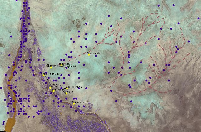
6 Study area Eastern Nile locality is situated in Khartoum State within the marginal rainfall area of the semiarid zone.
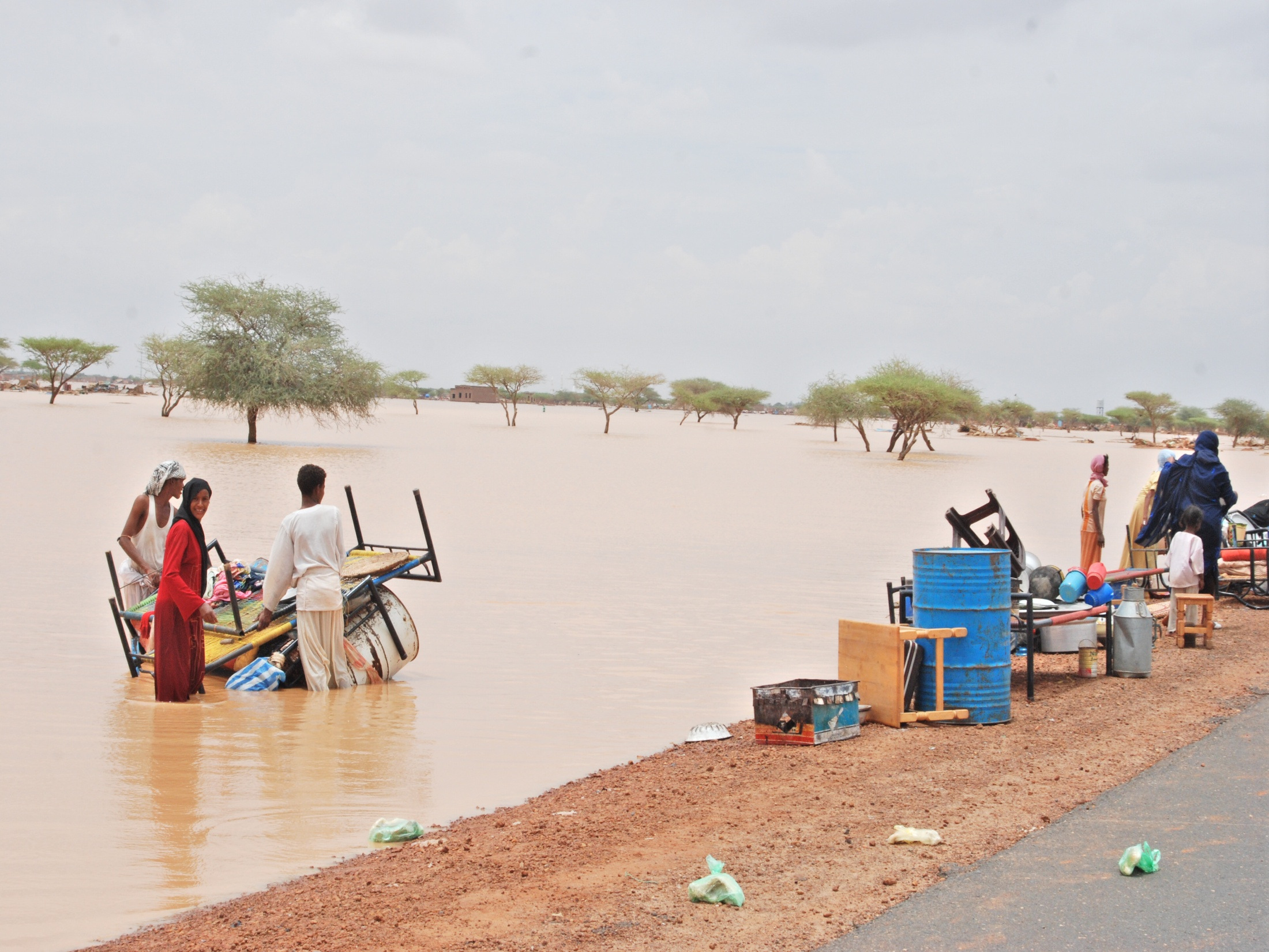
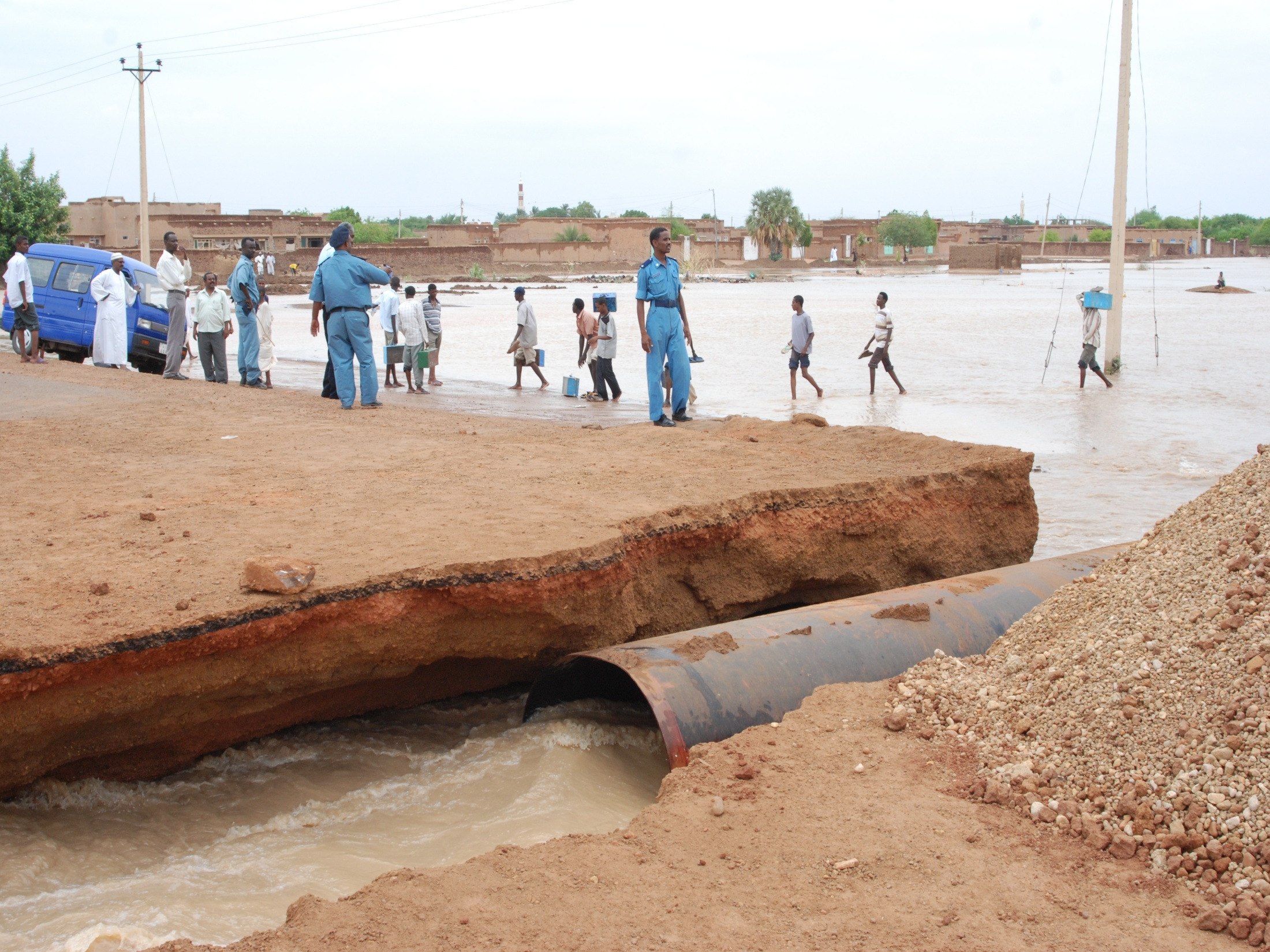
7 Research Problem The study area suffered from drought and flood. Rural communities in many villages in the study area have faced waves of drought and extreme flood events since the 1970s. To manage those problems a comprehensive information collecting and analysis should be implemented. summary of natural disasters in Sudan ( )
8

9 The Levee or Terrace Built for the protection of the villages floods

10 selected site showing the impact of 2007 floods
11
12
13 GIS & RS as tools remote sensing satellites offer synoptic view of water resources that facilitates surveying, and mapping of such resources. On the other hand, GIS enables storing data and information in digital format which facilitates their exchange and sharing between users. Likewise, GIS makes possible the integration and analysis of multi-source data so as to obtain additional information.
14 Research objectives Preparation of a digital map showing rivers, streams, and valleys. Demarcation of contributing areas (catchments) of rivers, streams, and valleys. Demarcation of preferred water harvest sites in the study area.
15 Materials Satellite images acquired by: Landsat 7 in :100,000 scale topographic maps (hardcopy). 1:250,000 scale topographic maps. Information taken from Google Earth. ASTER Global DEM 30m. Maps depicting other natural resources such as vegetation, soil, and geomorphology. Land use maps.
16 Methodologies
17 Flowchart Topographic and Thematic Maps Input Data Satellite Images Processing the topographic and thematic maps Software Processing, analysis, layout Image processing Digitization of watercourses Population density Agriculturally promising areas Slope Intensity of surface drainage network Suitable areas for water harvest Other layers Output Database All water drainage network for study area (lines) Valleys > 300 m (polygons) Some watersheds for study area Roads Soil Analysis model
18 Satellite imagery. Input Data Topographic map
19 Analysis This model was based on three main factors: the natural and environmental factor including vegetation, soil, slope and drainage density; the social factor which focuses on the human and animal presence represented in cities, villages, and settlements; and the economic factor represented in the suitability of the location for agricultural production.
20 To achieve the study objectives database was built including surface watercourses layer in addition to the following: 1- Basins contributing to valleys: the digital elevation model was used to demarcate basins contributing to some valleys and streams in the study area.
21 3-Slope map: the digital elevation model was used to produce a slope map for the study area. 4-Climatic zones: Sudan climatic zones map was processed to get knowledge of the climatic zones of the study are. 5-Land use map: Africover map 2003 was used to get information about land use in the study area, focusing on land use regarding rain fed agriculture, irrigated agriculture, forests, and pastures. 6-Potential agricultural lands map: A hardcopy map was converted to digital format, georeferenced, processed and linked to the spatial database. 7-Cities, villages, and settlements map: This map was processed and added as a layer using the same geometric projection. 8-Roads map: main roads layer for the study area was created.
22 Analysis flowchart Condition layers Population density, potential agriculture, C, i= 1 4 i Physical layers Soil, vegetation, slope, Drainage density Reclassifying to zero-one data Reclassifying to significant categories Zero-one map X 01 Ci Weights of the different classes w Zero-one maps for every physical layer x i 01, i=1 4 Y = X i X01 01 Ci i = 1 4 Ci X s Scaling and adding physical layers X = 4 i=1 w x i 01 i=1 Suitability map X (input or output) Is flowing data Is a process Suitable - feasible layer Reclassifying suitability map X s
23 Natural Layers slope soil Vegetation density Drainage density =
24 Suitable areas for water harvesting
25 Condition Layers Potential agriculture Population density
26 Feasibility According to Population Density Harvesting suitability Population density x =
27 Feasibility according to population density layer
28 Feasibility according to potential agricultural areas Harvesting suitability Potential agriculture x =
29 Feasibility according to potential agriculture layer
30 Outputs
31
32 Slope map Thematic Maps
33
34 Vegetation Map
35 Suitable Areas for Water Harvesting
36 Thanks
Impact of water harvesting dam on the Wadi s morphology using digital elevation model Study case: Wadi Al-kanger, Sudan
 Impact of water harvesting dam on the Wadi s morphology using digital elevation model Study case: Wadi Al-kanger, Sudan H. S. M. Hilmi 1, M.Y. Mohamed 2, E. S. Ganawa 3 1 Faculty of agriculture, Alzaiem
Development of Rural Drinking Water Security Plan A Case Study from Raipur Block, Bhilwara District, Rajasthan
 Development of Rural Drinking Water Security Plan A Case Study from Raipur Block, Bhilwara District, Rajasthan Dr. B. K. Bhadra Scientist/Engr. SF Regional Remote Sensing Centre (RRSC-W) NRSC/ISRO, Dept.
Flood Zone Investigation by using Satellite and Aerial Imagery
 Flood Zone Investigation by using Satellite and Aerial Imagery Younes Daneshbod Islamic Azad University-Arsanjan branch Daneshgah Boulevard, Islamid Azad University, Arsnjan, Iran Email: daneshbod@gmail.com
Remote Sensing and GIS Application In Change Detection Study In Urban Zone Using Multi Temporal Satellite
 Remote Sensing and GIS Application In Change Detection Study In Urban Zone Using Multi Temporal Satellite R.Manonmani, G.Mary Divya Suganya Institute of Remote Sensing, Anna University, Chennai 600 025
Description of Simandou Archaeological Potential Model. 13A.1 Overview
 13A Description of Simandou Archaeological Potential Model 13A.1 Overview The most accurate and reliable way of establishing archaeological baseline conditions in an area is by conventional methods of
Geography Gr 10 to Gr 12
 Gr 10 to Gr 12 From Grade 10 to Grade 12 the subject of is offered in The NSC stream at the DSJ. In this regard the school has to follow the requirements and syllabii of the CAPS document for as set out
Regional cooperation in the IGAD sub-region: of transboundary water resources
 Regional cooperation in the IGAD sub-region: Using science to secure political commitment and financial support for joint management of transboundary water resources M. BABA SY Sahara and Sahel Observatory
Appendix J Online Questionnaire
 Appendix J Online Questionnaire In accordance with the Paperwork Reduction Act, this questionnaire was approved by the Office of Management and Budget (OMB). The OMB control number and expiration date
Land Use / Land Cover Mapping using Remote Sensing Data in Pravara River Basin, Akole, Maharashtra, India
 International Research Journal of Environment Sciences ISSN 2319 1414 Land Use / Land Cover Mapping using Remote Sensing Data in Pravara River Basin, Akole, Maharashtra, India Wawale Surindar G. 1 and
Global environmental information Examples of EIS Data sets and applications
 METIER Graduate Training Course n 2 Montpellier - february 2007 Information Management in Environmental Sciences Global environmental information Examples of EIS Data sets and applications Global datasets
A disaster occurs at the point of contact between social activities and a natural phenomenon of unusual scale.
 Hazard Mapping and Vulnerability Assessment Mr. Toshiaki Udono Senior Project Manager, Kansai Division, PASCO Corporation, Japan Mr. Awadh Kishor Sah Project Manager, Project Implementation Department,
Liberia Forest Mapping. World Bank January 2012
 Liberia Forest Mapping World Bank January 2012 Scope of presentation 1. Overview (5 min) 2. Service presentation (20 min) 3. Operational scenario (10min) 4. Service Utility Review (45 min) 5. Wrap-up and
SESSION 8: GEOGRAPHIC INFORMATION SYSTEMS AND MAP PROJECTIONS
 SESSION 8: GEOGRAPHIC INFORMATION SYSTEMS AND MAP PROJECTIONS KEY CONCEPTS: In this session we will look at: Geographic information systems and Map projections. Content that needs to be covered for examination
Abaya-Chamo Lakes Physical and Water Resources Characteristics, including Scenarios and Impacts
 LARS 2007 Catchment and Lake Research Abaya-Chamo Lakes Physical and Water Resources Characteristics, including Scenarios and Impacts Seleshi Bekele Awulachew International Water Management Institute Introduction
National Environment Awareness Campaign(NEAC) 2014-2015. Theme
 2014-2015. Theme") National Environment Awareness Campaign(NEAC) 2014-2015. Theme COMBATING DESERTIFICATION, LAND DEGRADATION AND DROUGHT Background Note Desertification is about land degradation: the loss of the land s
National Environment Awareness Campaign(NEAC) 2014-2015. Theme COMBATING DESERTIFICATION, LAND DEGRADATION AND DROUGHT Background Note Desertification is about land degradation: the loss of the land s
Flash Flood Science. Chapter 2. What Is in This Chapter? Flash Flood Processes
 Chapter 2 Flash Flood Science A flash flood is generally defined as a rapid onset flood of short duration with a relatively high peak discharge (World Meteorological Organization). The American Meteorological
GIS: Geographic Information Systems A short introduction
 GIS: Geographic Information Systems A short introduction Outline The Center for Digital Scholarship What is GIS? Data types GIS software and analysis Campus GIS resources Center for Digital Scholarship
Tennessee Watershed Modeling Tools. Southern Region Watershed Meeting, July 2005. Forbes Walker University of Tennessee Extension
 Tennessee Watershed Modeling Tools Southern Region Watershed Meeting, July 2005 Forbes Walker University of Tennessee Extension Outline Land Use and Water Quality in Tennessee Watershed models Watershed
Hydrologic Engineering Techniques for Regional Water Resources Planning
 US Army Corps of Engineers Hydrologic Engineering Center Hydrologic Engineering Techniques for Regional Water Resources Planning October 1969 Approved for Public Release. Distribution Unlimited. TP-17
Methods for Determination of Safe Yield and Compensation Water from Storage Reservoirs
 US Army Corps of Engineers Hydrologic Engineering Center Methods for Determination of Safe Yield and Compensation Water from Storage Reservoirs October 1966 Approved for Public Release. Distribution Unlimited.
Pipeline Routing using GIS and Remote Sensing Tobenna Opara Ocean Engineering Department University of Rhode Island Tobennaopara@my.uri.
 Pipeline Routing using GIS and Remote Sensing Tobenna Opara Ocean Engineering Department University of Rhode Island Tobennaopara@my.uri.edu Pipelines are utilized by the oil and gas industry to transport
Michigan Tech Research Institute Wetland Mitigation Site Suitability Tool
 Michigan Tech Research Institute Wetland Mitigation Site Suitability Tool Michigan Tech Research Institute s (MTRI) Wetland Mitigation Site Suitability Tool (WMSST) integrates data layers for eight biophysical
Grant All Detail Report 2013 Conservation Drainage Management Grants
 Grant All Detail Report 2013 Conservation Grants Grant Title 2013 Conservation Grants Martin Grant ID C13 3789 Organization Martin County Grant Awarded Amount $62,100.00 Grant Execution Date Required Match
Plan Plus Volume 1 No 1 2002 (117-123)
") Plan Plus Volume 1 No 1 2002 (117-123) APPLICATION OF GIS (GEOGRAPHIC INFORMATION SYSTEM) FOR LANDSLIDE HAZARD ZONATION AND MAPPING DISASTER PRONE AREA: A STUDY OF KULEKHANI WATERSHED, NEPAL Purna Chandra
Plan Plus Volume 1 No 1 2002 (117-123) APPLICATION OF GIS (GEOGRAPHIC INFORMATION SYSTEM) FOR LANDSLIDE HAZARD ZONATION AND MAPPING DISASTER PRONE AREA: A STUDY OF KULEKHANI WATERSHED, NEPAL Purna Chandra
DEVELOPING FLOOD VULNERABILITY MAP FOR NORTH KOREA INTROUDUCTION
 DEVELOPING FLOOD VULNERABILITY MAP FOR NORTH KOREA Soojeong Myeong, Research Fellow Hyun Jung Hong, Researcher Korea Environment Institute Seoul, South Korea 122-706 sjmyeong@yahoo.com hjhong@kei.re.kr
Building Drought Resilience through Land and Water Management
 Building Drought Resilience through Land and Water Management Request for Proposal for Development of strategic water infrastructure in selected sub-catchments of Lower Tana Basin, Kenya 1. Background
Introduction to GIS (Basics, Data, Analysis) & Case Studies. 13 th May 2004. Content. What is GIS?
 & Case Studies. 13 th May 2004. Content. What is GIS?") Introduction to GIS (Basics, Data, Analysis) & Case Studies 13 th May 2004 Content Introduction to GIS Data concepts Data input Analysis Applications selected examples What is GIS? Geographic Information
Introduction to GIS (Basics, Data, Analysis) & Case Studies 13 th May 2004 Content Introduction to GIS Data concepts Data input Analysis Applications selected examples What is GIS? Geographic Information
Gram Panchayat & Ward Boundary Delineation and Assets mapping
 Gram Panchayat & Ward Boundary Delineation and Assets mapping For Rural Development Department & State Election Commission, Govt. of Maharashtra MAHARASHTRA REMOTE SENSING APPLICATIONS CENTRE Autonomous
WEPP MODEL APPLICATIONS FOR EVALUATIONS OF BEST MANAGEMENT PRACTICES
 WEPP MODEL APPLICATIONS FOR EVALUATIONS OF BEST MANAGEMENT PRACTICES D.C. FLANAGAN 1, W.J. ELLIOT 2, J.R. FRANKENBERGER 3, C. HUANG 4 1 USDA-Agricultural Research Service, National Soil Erosion Research
Water Resources Development and Management in India - An Overview
 Water Resources Development and Management in India - An Overview A presentation by U. N. Panjiar Secretary to the Government of India This presentation Water resources scenario in India Water governance
Domestic Policy Framework on Adaptation to Climate Change in Water Resources: Case Study for India. Working Together to Respond to Climate Change
 Domestic Policy Framework on Adaptation to Climate Change in Water Resources: Case Study for India Working Together to Respond to Climate Change WATER ACCOUNTING OF INDIA S TOTAL WATER RESOURCES Unutilizable
Ponds- Planning, Design, Construction
 United States Department of Agriculture Soil Conservation Service Agriculture Handbook Number 590 Ponds- Planning, Design, Construction This handbook describes the requirements for building a pond. It
Bruce Orr and Zooey Diggory S T I L L W A T E R S C I E N C E S. Tom Dudley U C S A N T A B A R B A R A
 A case study from the lower Santa Clara River, CA: Strategic planning for control of Arundo donax and restoration of riparian vegetation in semi-arid landscapes Bruce Orr and Zooey Diggory S T I L L W
World Water and Climate Atlas
 International Water Management Institute World Water and Climate Atlas Direct access to water and climate data improves agricultural planning The IWMI World Water and Climate Atlas provides rapid access
Landslide Hazard Zonation Mapping Using GIS
 1 Weerasinghe K. M. 1 Landslide Hazard Zonation Mapping Using GIS Abstract: The central highlands of Sri Lanka comprising 20% of the total land area of the country is often threatened by landslides. The
GIS Feature Classes For MMTB - Nga Aho Rangahau SFF Project
 Layer ID Layer 1 New Zealand coastline 2 Boundary of the Maniapoto rohe 3 Roads layer from topographic maps 4 Digital elevation model (15m resolution) 5 Hillshade (15m resolution) 6 Landform elements -
ANALYSIS 3 - RASTER What kinds of analysis can we do with GIS?
 ANALYSIS 3 - RASTER What kinds of analysis can we do with GIS? 1. Measurements 2. Layer statistics 3. Queries 4. Buffering (vector); Proximity (raster) 5. Filtering (raster) 6. Map overlay (layer on layer
INTEGRATED ANALYTICAL HIERARCHY PROCESS MODELING OF WATERSHEDS FOR ENVIRONMENTALLY SUSTAINABLE DEVELOPMENT
 INTEGRATED ANALYTICAL HIERARCHY PROCESS MODELING OF WATERSHEDS FOR ENVIRONMENTALLY SUSTAINABLE DEVELOPMENT Rao Kumar Raghavendra 1 1 Professor & Head, Department of Civil Engineering, New Horizon College
Fort Dodge Stormwater Master Planning. Prepared By: Ralph C. Stark, Jr., P.E., C.F.M. Joel N. Krause, P.E., C.F.M.
 Fort Dodge Stormwater Master Planning Prepared By: Ralph C. Stark, Jr., P.E., C.F.M. Joel N. Krause, P.E., C.F.M. Project Location Project Background Flooding History Localized flooding and storm sewer
Natural Resource-Based Planning*
 Natural Resource-Based Planning* Planning, when done well, is among the most powerful tools available to communities. A solid plan, based on good natural resource information, guides rational land-use
Planning, Health and Environment Division
 18 Planning, Health and Environment Division A Planning Guide to Sustainable Drainage Systems Introduction Working in co-operation with the Environment Agency, Severn Trent Water Ltd., the Highway Authority
APPLICATION OF GOOGLE EARTH FOR THE DEVELOPMENT OF BASE MAP IN THE CASE OF GISH ABBAY SEKELA, AMHARA STATE, ETHIOPIA
 APPLICATION OF GOOGLE EARTH FOR THE DEVELOPMENT OF BASE MAP IN THE CASE OF GISH ABBAY SEKELA, AMHARA STATE, ETHIOPIA Abineh Tilahun Department of Geography and environmental studies, Adigrat University,
Corresponding Author:bashirrokni@yahoo.com
 Land use planning using the Geographic Information System (GIS) in Tandoreh National Park (Iran) Bashir Rokni Deilami 1, Afsaneh Sheikhi 1, Vahid Barati 2, Dermayana Arsal 3, Muhammad Isa Bala 4, Bello
1.7.0 Floodplain Modification Criteria
 1.7.0 Floodplain Modification Criteria 1.7.1 Introduction These guidelines set out standards for evaluating and processing proposed modifications of the 100- year floodplain with the following objectives:
Geospatial Information for disaster risk reduction and natural resources management. Rolando Ocampo Alcántar
 Geospatial Information for disaster risk reduction and natural resources management Rolando Ocampo Alcántar Content Background Geospatial Information for Disaster Management Risk Atlas Information Exchange
The Use of Geographic Information Systems in Risk Assessment
 The Use of Geographic Information Systems in Risk Assessment With Specific Focus on the RiVAMP Methodology Presented by Nadine Brown August 27, 2012 Climate Studies Group Mona Climate Change Workshop Presentation
Climate vulnerability assessment Risks from urban flooding Interactive science and policy assessment
 Climate vulnerability assessment Risks from urban flooding Interactive science and policy assessment Flood risk from extreme precipitation in Copenhagen - Modelling results Per Skougaard Kaspersen, DTU
FIFTH WATER INFORMATION SUMMIT: REGIONAL PERSPECTIVES ON WATER INFORMATION MANAGEMENT SYSTEMS
 FIFTH WATER INFORMATION SUMMIT: REGIONAL PERSPECTIVES ON WATER INFORMATION MANAGEMENT SYSTEMS OCTOBER 23-25 WATERWEB CONSORTIUM, FORT LAUDERDALE, FLORIDA USA 2002 MANAGING OF WATERSHEDS OF STANBUL (TURKEY)
COMPREHENSIVE PLAN SECTION B, ELEMENT 4 WATER RESOURCES. April 20, 2010 EXHIBIT 1
 COMPREHENSIVE PLAN SECTION B, ELEMENT 4 WATER RESOURCES April 20, 2010 EXHIBIT 1 ELEMENT 4 WATER RESOURCES TABLE OF CONTENTS 4.1 INTRODUCTION 4.2 GOALS AND POLICIES 4.2.A General Goals and Policies 1 4.2.B
HAZARD RISK ASSESSMENT, MONITORING, MAINTENANCE AND MANAGEMENT SYSTEM (HAMMS) FOR LANDSLIDE AND FLOOD. Mohd. Nor Desa, Rohayu and Lariyah, UNITEN
 FOR LANDSLIDE AND FLOOD. Mohd. Nor Desa, Rohayu and Lariyah, UNITEN") HAZARD RISK ASSESSMENT, MONITORING, MAINTENANCE AND MANAGEMENT SYSTEM (HAMMS) FOR LANDSLIDE AND FLOOD Mohd. Nor Desa, Rohayu and Lariyah, UNITEN WHAT WE HAVE IN MIND AND FROM OUR PREVIOUS PROJECT CONTRIBUTION
HAZARD RISK ASSESSMENT, MONITORING, MAINTENANCE AND MANAGEMENT SYSTEM (HAMMS) FOR LANDSLIDE AND FLOOD Mohd. Nor Desa, Rohayu and Lariyah, UNITEN WHAT WE HAVE IN MIND AND FROM OUR PREVIOUS PROJECT CONTRIBUTION
Planning Resource Guide. Climate Change Adaptation through Land Use Planning
 Planning Resource Guide Climate Change Adaptation through Land Use Planning i The new Provincial Planning regulation continues to promote sound land use planning and express the provincial interest in
Earth Science. River Systems and Landforms GEOGRAPHY 1710. The Hydrologic Cycle. Introduction. Running Water. Chapter 14.
 Earth Science GEOGRAPHY 1710 River Systems and Landforms DAVID R. SALLEE Robert W. Christopherson Charlie Thomsen Chapter 14 Introduction Rivers and streams are dynamic systems that continually adjust
ADVANCED GEO-TECH SOLUTIONS
 Office Reg. No.: 9992 194019 Service T.No. : AGSPL 3094 PSD 001 PAN NO.: AGSPL 3094 P TAN NO. : LKNC 06091 B ADVANCED GEO-TECH SOLUTIONS ISO 9001 ; 2008 STANDARDS 1 / 643, Sector H, Jankipuram LUCKNOW
DISASTER RISK DETECTION AND MANAGEMENT COURSES SETUP SCENARIO AT MAKERERE UNIVERSITY. Makerere University
 DISASTER RISK DETECTION AND MANAGEMENT COURSES SETUP SCENARIO AT MAKERERE UNIVERSITY CASE OF THE DEPARTMENT OF GEOGRAPHY Derek Muhwezi 2 MISSION OF THE DEPARTMENT To provide and promote quality education,
GEOLOGY AND GEOMORPHOLOGY Level. bachelor Semester. winter ECTS 9
 GEOLOGY AND GEOMORPHOLOGY ECTS 9 The subject includes knowledge of the construction of the Earth and the natural processes occurring deeply inside and on the surface of the Earth. It contains characteristics
Henry Van Offelen Natural Resource Scientist MN Center for Environmental Advocacy hvanoffelen@mncenter.org
 Henry Van Offelen Natural Resource Scientist MN Center for Environmental Advocacy hvanoffelen@mncenter.org Wetland study slide Water Quality NRE goals in watershed plans Protect habitat that remains.
COASTAL MONITORING & OBSERVATIONS LESSON PLAN Do You Have Change?
 Coastal Change Analysis Lesson Plan COASTAL MONITORING & OBSERVATIONS LESSON PLAN Do You Have Change? NOS Topic Coastal Monitoring and Observations Theme Coastal Change Analysis Links to Overview Essays
A Developer s Guide: Watershed-Wise Development
 A Developer s Guide: Watershed-Wise Development Environmental Protection What is a watershed? It does not matter how far away you build from a creek, lake, or the ocean, you are in a watershed. Another
The Potentials and Impacts of Water Harvesting Projects in Arid and Semi-Arid Regions (based on lessons learnt from some Implemented cases in Iran)
") The Potentials and Impacts of Water Harvesting Projects in Arid and Semi-Arid Regions (based on lessons learnt from some Implemented cases in Iran) Dr F. Sharifi Watershed Management and SCWM Institute,
The Potentials and Impacts of Water Harvesting Projects in Arid and Semi-Arid Regions (based on lessons learnt from some Implemented cases in Iran) Dr F. Sharifi Watershed Management and SCWM Institute,
Understanding Raster Data
 Introduction The following document is intended to provide a basic understanding of raster data. Raster data layers (commonly referred to as grids) are the essential data layers used in all tools developed
The needs on big data management for Operational Geo-Info Services: Emergency Response, Maritime surveillance, Agriculture Management
 Copernicus Big-Data Workshop 2014, 13/14 March The needs on big data management for Operational Geo-Info Services: Emergency Response, Maritime surveillance, Agriculture Management Marco Corsi e-geos 1
Introduction to Rainwater Harvesting. Department of Biological and Agricultural Engineering Texas A&M University
 Introduction to Rainwater Harvesting Department of Biological and Agricultural Engineering Texas A&M University Rainfall in your watershed What is a watershed? An area of land that drains to a common point
Applying MIKE SHE to define the influence of rewetting on floods in Flanders
 Applying MIKE SHE to define the influence of rewetting on floods in Flanders MARK HENRY RUBARENZYA 1, PATRICK WILLEMS 2, JEAN BERLAMONT 3, & JAN FEYEN 4 1,2,3 Hydraulics Laboratory, Department of Civil
WILLOCHRA BASIN GROUNDWATER STATUS REPORT 2009-10
 WILLOCHRA BASIN GROUNDWATER STATUS REPORT 2009-10 SUMMARY 2009-10 The Willochra Basin is situated in the southern Flinders Ranges in the Mid-North of South Australia, approximately 50 km east of Port Augusta
Guidance for Flood Risk Analysis and Mapping. Changes Since Last FIRM
 Guidance for Flood Risk Analysis and Mapping Changes Since Last FIRM May 2014 This guidance document supports effective and efficient implementation of flood risk analysis and mapping standards codified
ADWR GIS Metadata Policy
 ADWR GIS Metadata Policy 1 PURPOSE OF POLICY.. 3 INTRODUCTION.... 4 What is metadata?... 4 Why is it important? 4 When to fill metadata...4 STANDARDS. 5 FGDC content standards for geospatial metadata...5
ERITREA: NAPA PROJECT PROFILE
 ERITREA: NAPA PROJECT PROFILE 1. Introducing community based pilot rangeland improvement and management in selected agro-ecological areas in the eastern and northwestern lowlands rangelands 2. Introducing
INDONESIA - LAW ON WATER RESOURCES,
 Environment and Development Journal Law LEAD INDONESIA - LAW ON WATER RESOURCES, 2004 VOLUME 2/1 LEAD Journal (Law, Environment and Development Journal) is a peer-reviewed academic publication based in
London Borough of Waltham Forest LOCAL FLOOD RISK MANAGEMENT STRATEGY. Summary Document
 LOCAL FLOOD RISK MANAGEMENT STRATEGY Summary Document October 2013 Local Flood Risk Management Strategy Summary 1 Introduction 2 Partner responsibilities 3 What do we know about flooding in the borough?
Massoud Abd El-aty Massoud Aly
 (CURRICULUM VITAE) Massoud Abd El-aty Massoud Aly BIRTH DATE: 1/10/1960 MARTIAL STATUS: Married + 4 Work: (Tel. & Fax: 009663-5816611, Tel. Central: 5816600 Ext. 2165) Home: (009663-5806832, 00203-5737434)
Flood Damage Prevention in Delaware County, NY
 Flood Damage Prevention in Delaware County, NY Susquehanna Basin 2 Villages, 8 Hamlets Schoharie Basin 1 Hamlet Cannonsville Basin 4 Villages, 6 Hamlets Pepacton Basin 2 Villages, 6 Hamlets Upper Delaware
Challenges. Estimated Damages from 100-Year Flood
 Suffield Suffield is a rural community located along the Massachusetts border. It encompasses about 42.2 square miles and has a population of about 15,735. Suffield s terrain rises from an elevation of
dynamic vegetation model to a semi-arid
 Application of a conceptual distributed dynamic vegetation model to a semi-arid basin, SE of Spain By: M. Pasquato, C. Medici and F. Francés Universidad Politécnica de Valencia - Spain Research Institute
Application of Google Earth for flood disaster monitoring in 3D-GIS
 Disaster Management and Human Health Risk II 271 Application of Google Earth for flood disaster monitoring in 3D-GIS M. Mori & Y. L. Chan Department of Information and Computer Science, Kinki University,
Mapping and Modelling the Impact of Land Use Planning and Management Practices on Urban and Peri-Urban Landscapes in the Greater Dublin Area
 Mapping and Modelling the Impact of Land Use Planning and Management Practices on Urban and Peri-Urban Landscapes in the Greater Dublin Area Dr. Martin Critchley Era-Maptec Ltd 36 Dame Street Dublin 2
specification AS/A Level GCE GCE Geography version 4 September 2013 OCR Advanced Subsidiary GCE in Geography H083 OCR Advanced GCE in Geography H483
 AS/A Level GCE GCE Geography OCR Advanced Subsidiary GCE in Geography H083 OCR Advanced GCE in Geography H483 version 4 September 2013 specification OCR 2013 QAN 500/2613/6 QAN 500/2585/5 Contents 1 About
Global water resources under increasing pressure from rapidly growing demands and climate change, according to new UN World Water Development Report
 WWDR4 Background Information Brief Global water resources under increasing pressure from rapidly growing demands and climate change, according to new UN World Water Development Report As demand for water
GIS Data assessment for Region II of Chile Implications for international Water Resource Databases
 GIS Data assessment for Region II of Chile Implications for international Water Resource Databases GIS in Water Resources (CE 394K) Term Paper Benjamin Bass December 2 nd, 2011 Wikimedia Commons SITHA
FLOOD PROTECTION AND ECOSYSTEM SERVICES IN THE CHEHALIS RIVER BASIN. May 2010. Prepared by. for the. 2010 by Earth Economics
 FLOOD PROTECTION AND ECOSYSTEM SERVICES IN THE CHEHALIS RIVER BASIN May 2010 Prepared by for the Execubve Summary The Chehalis Basin experienced catastrophic flooding in 2007 and 2009. In response, the
DOÑA ANA COUNTY DESIGN STORM CRITERIA GUIDELINES FOR COMMERCIAL AND RESIDENTIAL SITES. Run-off Analysis Methods
 DOÑA ANA COUNTY DESIGN STORM CRITERIA GUIDELINES FOR COMMERCIAL AND RESIDENTIAL SITES Run-off Analysis Methods This document sets forth the minimum design, technical criteria and specifications for the
Introduction. The vision of the West Yorkshire Combined Authority (WYCA) Flood Risk Partnership
 Flood Risk Partnership") WYCA SuDS Guidance Introduction As part of the government s continuing commitment to protect people and property from flood risk, the Department for Communities and Local Government and the Department
WYCA SuDS Guidance Introduction As part of the government s continuing commitment to protect people and property from flood risk, the Department for Communities and Local Government and the Department
The AIR Inland Flood Model for the United States In Spring 2011, heavy rainfall and snowmelt produced massive flooding along the Mississippi River,
 The AIR Inland Flood Model for the United States In Spring 2011, heavy rainfall and snowmelt produced massive flooding along the Mississippi River, inundating huge swaths of land across seven states. As
Complementary Additional Programme 2014-2015 / Concept note. South Sudan. 24 Months US$ 5,000,000
 Complementary Additional Programme 2014-2015 / Concept note Increasing Resilience to Floods in South Sudan Geographical scope/benefitting country(ies) Duration (in months) Name and Unit of project Officer
JACIE Science Applications of High Resolution Imagery at the USGS EROS Data Center
 JACIE Science Applications of High Resolution Imagery at the USGS EROS Data Center November 8-10, 2004 U.S. Department of the Interior U.S. Geological Survey Michael Coan, SAIC USGS EROS Data Center coan@usgs.gov
River Flood Damage Assessment using IKONOS images, Segmentation Algorithms & Flood Simulation Models
 River Flood Damage Assessment using IKONOS images, Segmentation Algorithms & Flood Simulation Models Steven M. de Jong & Raymond Sluiter Utrecht University Corné van der Sande Netherlands Earth Observation
Indiana Office of Community and Rural Affairs. Disaster Recovery and Mitigation Planning Ft. Worth, Texas February 15, 2012
 Indiana Office of Community and Rural Affairs Disaster Recovery and Mitigation Planning Ft. Worth, Texas February 15, 2012 Floods Indiana s costliest hazard State ranks 5 th in annual median flood damages
Basin-Scale Stream-Aquifer Modeling of the Lower Arkansas River, Colorado
 Hydrology Days Basin-Scale Stream-Aquifer Modeling of the Lower Arkansas River, Colorado Enrique Triana 1 Graduate Research Assistant and PhD candidate, Civil Engineering Department, Colorado State University,
Overview of NASA Applied Remote Sensing Training Program on Water Resources and Disaster Management
 Overview of NASA Applied Remote Sensing Training Program on Water Resources and Disaster Management ARSET Applied Remote SEnsing Training A project of NASA Applied Sciences Outline About ARSET ARSET Trainings
Monitoring Overview with a Focus on Land Use Sustainability Metrics
 Monitoring Overview with a Focus on Land Use Sustainability Metrics Canadian Roundtable for Sustainable Crops. Nov 26, 2014 Agriclimate, Geomatics, and Earth Observation Division (ACGEO). Presentation
Ensuring Water Security for the sustainability of the Hani Rice Terraces, China against Climate and Land Use changes
 Rice Terrace Farming Systems Working Paper Series Number 2 June 215 Ensuring Water Security for the sustainability of the Hani Rice Terraces, China against Climate and Land Use changes Herath Srikantha
Trend in Land Use/Land Cover Change Detection by RS and GIS Application
 Trend in Land Use/Land Cover Change Detection by RS and GIS Application N. Nagarajan 1, S. Poongothai 2 1 Assistant Professor, 2 Professor Department of Civil Engineering, FEAT, Annamalai University, Tamilnadu,
Utah State General Records Retention Schedule SCHEDULE 1 GEOSPATIAL DATA SETS
 Utah State General Records Retention Schedule SCHEDULE 1 BIOTA RECORDS (Item 1-26) These are geospatial records that depict wildlife use areas in the state of Utah as determined by wildlife biologists
Survey and Mapping Activities in Vietnam *
 UNITED NATIONS E/CONF.100/CRP.1 ECONOMIC AND SOCIAL COUNCIL Eighteenth United Nations Regional Cartographic Conference for Asia and the Pacific Bangkok, 26-29 October 2009 Item 7(a) of the provisional
Welcome to NASA Applied Remote Sensing Training (ARSET) Webinar Series
 Webinar Series") Welcome to NASA Applied Remote Sensing Training (ARSET) Webinar Series Introduction to Remote Sensing Data for Water Resources Management Course Dates: October 17, 24, 31 November 7, 14 Time: 8-9 a.m.
Welcome to NASA Applied Remote Sensing Training (ARSET) Webinar Series Introduction to Remote Sensing Data for Water Resources Management Course Dates: October 17, 24, 31 November 7, 14 Time: 8-9 a.m.
Utilizing satellite-based information for disaster risk assessment- why and how?
 Utilizing satellite-based information for disaster risk assessment- why and how? Peeranan Towashiraporn ADPC Session 1, UN International Conference on Space-based Technologies for Disaster Management September
Relational GIS and Remote Sensing Database System for Al-Salt Area, Jordan
 American J. of Engineering and Applied Sciences 1 (4): 241-247, 2008 ISSN 1941-7020 2008 Science Publications Relational GIS and Remote Sensing Database System for Al-Salt Area, Jordan Eyad H.R. Fadda,
REPUBLIC OF TURKEY MINISTRY OF FORESTRY AND WATER AFFAIRS
 REPUBLIC OF TURKEY MINISTRY OF FORESTRY AND WATER AFFAIRS Turkey s position in the World Prof. Dr. Veysel EROĞLU Minister of Forestry and Water Affairs The Ministry of Forestry and Water Affairs, formerly
Stage 4. Geography. Blackline Masters. By Karen Devine
 1 Devine Educational Consultancy Services Stage 4 Geography Blackline Masters By Karen Devine Updated January 2010 2 This book is intended for the exclusive use in NSW Secondary Schools. It is meant to
Web-based GIS Application of the WEPP Model
 Web-based GIS Application of the WEPP Model Dennis C. Flanagan Research Agricultural Engineer USDA - Agricultural Research Service National Soil Erosion Research Laboratory West Lafayette, Indiana, USA
Figure 1.1 The Sandveld area and the Verlorenvlei Catchment - 2 -
 Figure 1.1 The Sandveld area and the Verlorenvlei Catchment - 2 - Figure 1.2 Homogenous farming areas in the Verlorenvlei catchment - 3 - - 18 - CHAPTER 3: METHODS 3.1. STUDY AREA The study area, namely