FORMATION OF THE AUCKLAND WEST COAST
|
|
|
- Solomon Nash
- 7 years ago
- Views:
Transcription
1 FORMATION OF THE AUCKLAND WEST COAST
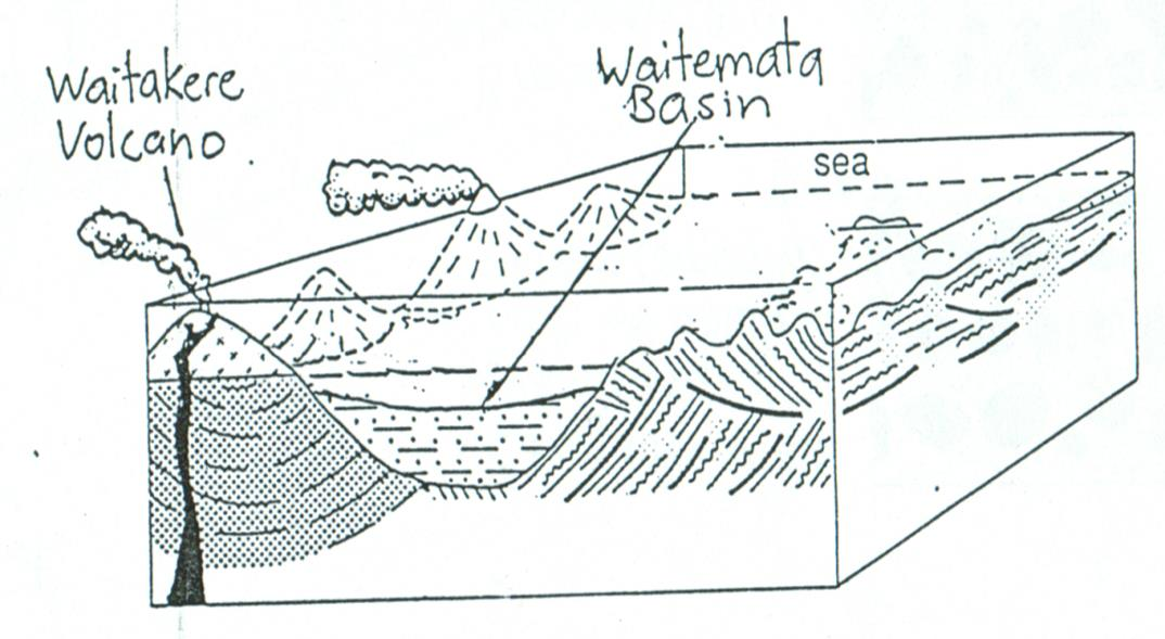
2 Geological Evolution of the Waitakere Ranges/West Coast Natural Landscape Stage 1 Underwater Waitakere Volcano million years ago Stage 2 Tectonic Uplift and Small Eruptions million years ago Stage 3 Period of Erosion 14-5 million years ago Stage 4 (a) Tectonic Uplift: Range-building (b) Deposition: Sand Dune Development along Coast 5 million years ago to the present day 1.5 million years to the present day
3 Stage 1: Underwater Waitakere Volcano (24-17 million years ago) The Waitakere Ranges originated about 24 million years ago when what is now the Auckland region was under water in a deep-sea trough. Geologists call this deep trough the Waitemata Basin. It stretched from Dargaville in the north to Hamilton in the south and was edged by a landmass to the east that stretched from Whangarei to the present Coromandel Peninsula. To the west of the trough a giant andesite volcano was actively growing on the floor of the sea. The centre of this volcano was 20kms west of the present-day Wait4ere Ranges. Periodic eruptions of lava, pumice and ash spewed on to the ocean floor and, eventually, the volcano rose above sea level to form one of a line of active volcanic islands.
4
5 The ancient Waitakere Volcano was similar to the andesite volcanoes of Ruapehu, Ngauruhoe and Tongariro, but it grew to around five times the size of all three of these volcanoes combined. It was active for six to seven million years and built to 3000m in height with a 50km diameter. The present Waitakere Ranges are the highly eroded remains of just the eastern slopes of the huge Waitakere Volcano.

6 Most of the Waitakere Ranges today consists of weakly layered volcanic conglomerates and breccia that swept down the sides of the growing volcano in undersea láhars (also called turbidity flows). These lahars came to rest on the ancient volcano's lower slopes, 2000m below sea level. Conglomerates are pebbles and boulders that have been rounded by the sea and then held together in a cement-like grit; breccia is formed in the same way as conglomerates but with angular rocks. We can see evidence of these rock-types in the cliffs along Auckland's west coast beaches. Occasionally, much larger undersea lahars flowed 30 to 50kms eastwards into the submarine trough before coming to rest on the sea floor. Today, we can see some of these thick, uplifted and exposed beds of volcanic breccia and grit in the cliffs beside Auckland's Parnell Baths and in the cliffs of North, Shore's East Coast Bays.

7 Stage 2: Tectonic Uplift and Small Eruptions (17 14 million years ago) About 17 million years ago, as its volcanic activity was drawing to a close, the Waitakere Volcano was pushed up out of the sea by deep tectonic forces to form an uplifted block.
8 Two lines of small volcanic vents began erupting on the eastern side of this uplifted block. Today, the remains of one line of vents are located near Scenic Drive in the Waitakere Ranges. The remains of the second, more active line of vents and volcanic dykes can be seen in the cliffs along Auckland's West Coast beaches. Lion Rock at Piha, is one of these eroded volcanic vents. It is composed of scoria, volcanic bombs and lava flows that collapsed back into the vent. Other volcanic remains are explosion craters filled with lava flows or domes of lava, such as Watchman Island at Karekare and the cliffs of White's and O'Neill's beaches further north. The two lines of vents poured extensive lava flows over the surrounding land. Today, these ancient lava flows form a thin eroded cap along the ridges of the Waitakere Ranges. They can be seen as the weathered red and purple clays in many of the road cuttings along Piha Road.
9

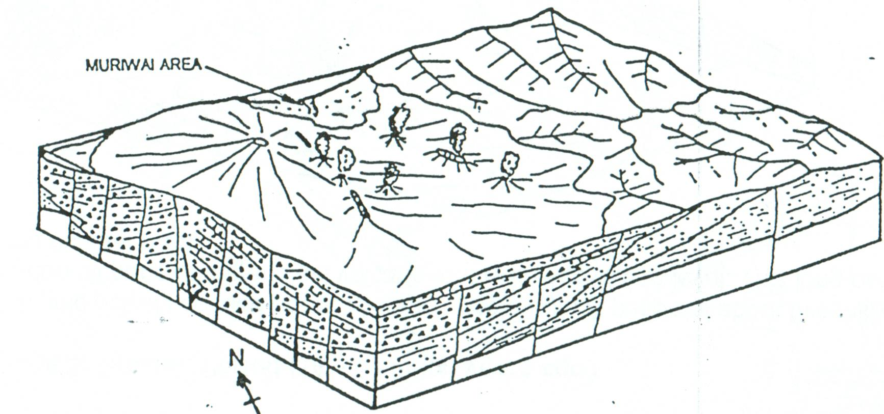
10 Stage 3: Erosion Period (14-5 million years ago) Volcanic activity ceased about 14 million years ago. A period of about five million years followed where the Tasman Sea eroded all parts of the ancient volcano that were above sea level. This long period of erosion resulted in an extensive low- lying coastal plain.
11 Stage 4(a): Tectonic Uplift: Range-building (5 million years ago - present day) Following the period of erosion, tectonic forces pushed up the coastal plain to form a plateau that was gently tilted to the northwest. In the last one or two million years, erosion by streams has dissected the plateau into relatively steep-sided valleys and, formed narrow floodplains where these streams flow out to the coast. Erosion by the sea has created high coastal cliffs, stacks, caves and blowholes on the western edge of the Waitakere Ranges.

12 Stage 4(b): Deposition: Sand Dune Development along Coast (1.5 million-years ago - present day) Sand dunes have developed along the west coast of.the Waitakere Ranges since the last Ice Age. The sources of sand have been volcanic material discharged by the Waikato River and Taranaki iron sands. Sea currents have transported this sand northwards; waves have moved the sand onto beaches; westerly winds have blown it inland. At Muriwai, the Kaipara South Heads is a major sand barrier that has been built by this process.
Earth Science Landforms, Weathering, and Erosion Reading Comprehension. Landforms, Weathering, and Erosion
 Reading Comprehension Name 1 How many people have been to the Rocky Mountains or the Grand Canyon? When people go to visit these natural wonders, they may not realize that it took millions of years for
Rapid Changes in Earth s Surface
 TEKS investigate rapid changes in Earth s surface such as volcanic eruptions, earthquakes, and landslides Rapid Changes in Earth s Surface Constant Changes Earth s surface is constantly changing. Wind,
How Did These Ocean Features and Continental Margins Form?
 298 10.14 INVESTIGATION How Did These Ocean Features and Continental Margins Form? The terrain below contains various features on the seafloor, as well as parts of three continents. Some general observations
WEATHERING, EROSION, AND DEPOSITION PRACTICE TEST. Which graph best shows the relative stream velocities across the stream from A to B?
 NAME DATE WEATHERING, EROSION, AND DEPOSITION PRACTICE TEST 1. The diagram below shows a meandering stream. Measurements of stream velocity were taken along straight line AB. Which graph best shows the
Climate, Vegetation, and Landforms
 Climate, Vegetation, and Landforms Definitions Climate is the average weather of a place over many years Geographers discuss five broad types of climates Moderate, dry, tropical, continental, polar Vegetation:
2 Wind Erosion and Deposition
 CHAPTER 3 2 Wind Erosion and Deposition SECTION Agents of Erosion and Deposition BEFORE YOU READ After you read this section, you should be able to answer these questions: How can wind erosion shape the
All sediments have a source or provenance, a place or number of places of origin where they were produced.
 Sedimentary Rocks, Processes, and Environments Sediments are loose grains and chemical residues of earth materials, which include things such as rock fragments, mineral grains, part of plants or animals,
Ride the Rock Cycle. Suggested Goals: Students will gain an understanding of how a rock can move through the different stages of the rock cycle.
 Illinois State Museum Geology Online http://geologyonline.museum.state.il.us Ride the Rock Cycle Grade Level: 5 6 Purpose: To teach students that the rock cycle, like the water cycle, has various stages
BASIC LESSON Objective(s)
") [Geology - Landforms] [K-1: Basic] [Grades 2-3: Advanced] BACKGROUND Landforms are natural features of the Earth's surface. They are created by the movement of ice or water, earthquakes, lava flows, volcanoes,
[Geology - Landforms] [K-1: Basic] [Grades 2-3: Advanced] BACKGROUND Landforms are natural features of the Earth's surface. They are created by the movement of ice or water, earthquakes, lava flows, volcanoes,
Chapter 8: Plate Tectonics -- Multi-format Test
 Name: Class: Date: ID: A Chapter 8: Plate Tectonics -- Multi-format Test Modified True/False Indicate whether the statement is true or false. If false, change the identified word or phrase to make the
Igneous rocks formed when hot molten material (magma) cools and hardens (crystallizes).
 cools and hardens (crystallizes).") Objectives You will learn about how the land of North Dakota was formed. Introduction North Dakota is a wonderful place to live. Have you ever though about how it was formed? To answer that question, you
Objectives You will learn about how the land of North Dakota was formed. Introduction North Dakota is a wonderful place to live. Have you ever though about how it was formed? To answer that question, you
CATACLYSMIC ERUPTIONS
 CATACLYSMIC ERUPTIONS The really big ones! This figure compares the size of some recent, well-known eruptions. Note how small the eruptions of Mount St. Helens and even Vesuvius are compared to Katmai,
6.E.2.2 Plate Tectonics, Earthquakes and Volcanoes
 Name: Date: 1. The road shown below was suddenly broken by a natural event. 3. The convergence of two continental plates would produce Which natural event most likely caused the crack in the road? island
FROM SEDIMENT INTO SEDIMENTARY ROCK. Objectives. Sediments and Sedimentation
 FROM SEDIMENT INTO SEDIMENTARY ROCK Objectives Identify three types of sediments. Explain where and how chemical and biogenic sediments form. Explain three processes that lead to the lithification of sediments.
Geomorphology is the Study of Landforms. Usually by Erosion, Transportation and Deposition
 Geomorphology is the Study of Landforms and the Processes that t Create Them, Usually by Erosion, Transportation and Deposition Fluvial = running water, rivers and floodplains Glacial = flowing ice in
Chapter Overview. Bathymetry. Measuring Bathymetry. Echo Sounding Record. Measuring Bathymetry. CHAPTER 3 Marine Provinces
 Chapter Overview CHAPTER 3 Marine Provinces The study of bathymetry charts ocean depths and ocean floor topography. Echo sounding and satellites are efficient bathymetric tools. Most ocean floor features
TECTONICS ASSESSMENT
 Tectonics Assessment / 1 TECTONICS ASSESSMENT 1. Movement along plate boundaries produces A. tides. B. fronts. C. hurricanes. D. earthquakes. 2. Which of the following is TRUE about the movement of continents?
Ocean Floor Continental Slope Begins at the Continental Shelf Very sharp drop to depths over 2 miles Covered with thick layers of sand, mud, and rocks
 Ocean Floor Continental Shelf Begins at the shoreline Gently slopes underwater Average depth of 430 feet Thick layers of sand, mud, and rocks The beach is part of the Continental Shelf Ocean Floor Continental
4. Plate Tectonics II (p. 46-67)
") 4. Plate Tectonics II (p. 46-67) Seafloor Spreading In the early 1960s, samples of basaltic ocean crust were dredged up from various locations across the ocean basins. The samples were then analyzed to
4. Plate Tectonics II (p. 46-67) Seafloor Spreading In the early 1960s, samples of basaltic ocean crust were dredged up from various locations across the ocean basins. The samples were then analyzed to
Rocks and Minerals What is right under your feet?
 Rocks and Minerals What is right under your feet? Name: 1 Before you start What do you already know? What is the difference between a rock and a mineral? What are the three categories of rocks? 1. 2. 3.
Interactive Plate Tectonics
 Interactive Plate Tectonics Directions: Go to the following website and complete the questions below. http://www.learner.org/interactives/dynamicearth/index.html How do scientists learn about the interior
Unit 6 Earthquakes and Volcanoes
 Unit 6 Earthquakes and Volcanoes Earthquakes and Volcanoes: Essential Questions What evidence can students observe that the Earth is changing? How do scientists know what s inside the Earth? What processes
Regents Questions: Plate Tectonics
 Earth Science Regents Questions: Plate Tectonics Name: Date: Period: August 2013 Due Date: 17 Compared to the oceanic crust, the continental crust is (1) less dense and more basaltic (3) more dense and
Rocks and Plate Tectonics
 Name: Class: _ Date: _ Rocks and Plate Tectonics Multiple Choice Identify the choice that best completes the statement or answers the question. 1. What is a naturally occurring, solid mass of mineral or
Earth Science Chapter 14 Section 2 Review
 Name: Class: Date: Earth Science Chapter 14 Section Review Multiple Choice Identify the choice that best completes the statement or answers the question. 1. Which of the following is NOT one of the three
LANDFORMS OF THE EARTH STD VIII
 LANDFORMS OF THE EARTH STD VIII 1) What do you understand by the term geomorphology? A) Geomorphology is the systematic study of the Earth s relief features. Geo means earth; morph meaning form and ology
Rosaly Lopes, Jet Propulsion Laboratory, California Institute of Technology
 Saturn s Moon Titan: Cassini-Huygens Reveals a New World Rosaly Lopes, Jet Propulsion Laboratory, California Institute of Technology The year 2005 will be remembered in the history of space exploration
The Geology of the Marginal Way, Ogunquit, Maine
 Geologic Site of the Month February, 2002 The Geology of the Marginal Way, Ogunquit, Maine 43 14 23.88 N, 70 35 18.36 W Text by Arthur M. Hussey II, Bowdoin College and Robert G. Marvinney,, Department
Laboratory 6: Topographic Maps
 Name: Laboratory 6: Topographic Maps Part 1: Construct a topographic map of the Egyptian Pyramid of Khafre A topographic map is a two-dimensional representation of a three-dimensional space. Topographic
not to be republished NCERT MAJOR LANDFORMS OF THE EARTH
 6 You must have seen some of the landform features as shown in the Figure 6.1 below. You will notice that the surface of the earth is not the same everywhere. The earth has an infinite variety of landforms.
Sedimentary Rocks. Find and take out 11B-15B and #1 From Egg Carton
 Sedimentary Rocks Find and take out 11B-15B and #1 From Egg Carton Erosion Erosion is a natural process where rocks and soil are Broken and Moved We will focus on 4 types of erosion; Wind, Rain, Ice and
NATURAL REGIONS OF KENTUCKY
 NATURAL WONDERS As you travel around Kentucky taking pictures, you are excited by what you see. Kentucky offers diverse and amazing sights. The Six Regions In the West, you see the Mississippi River, the
College of Science and Health ENVIRONMENTAL SCIENCE & GEOGRAPHY Course Outline
 College of Science and Health ENVIRONMENTAL SCIENCE & GEOGRAPHY Course Outline 1. TITLE OF COURSE AND COURSE NUMBER: General Geology ENV 115, 4 credits 2. DESCRIPTION OF THE COURSE: Includes the study
Tectonic plates push together at convergent boundaries.
 KEY CONCEPT Plates converge or scrape past each other. BEFORE, you learned Plates move apart at divergent boundaries In the oceans, divergent boundaries mark where the sea floor spreads apart On land,
Continents join together and split apart.
 KEY CONCEPT Continents change position over time. BEFORE, you learned Earth s main layers are the core, the mantle, and the crust The lithosphere and asthenosphere are the topmost layers of Earth The lithosphere
Plate Tectonics: Big Ideas. Plate Tectonics. Plate Tectonics. The unifying concept of the Earth sciences.
 Plate Tectonics: Big Ideas Our understanding of Earth is continuously refined. Earth s systems are dynamic; they continually react to changing influences from geological, hydrological, physical, chemical,
Plate Tectonics. Plate Tectonics The unifying concept of the Earth sciences. Continental Drift
 Plate Tectonics The unifying concept of the Earth sciences. The outer portion of the Earth is made up of about 20 distinct plates (~ 100 km thick), which move relative to each other This motion is what
CONFIRMATION AND CALIBRATION OF COMPUTER MODELING OF TSUNAMIS PRODUCED BY AUGUSTINE VOLCANO, ALASKA
 CONFIRMATION AND CALIBRATION OF COMPUTER MODELING OF TSUNAMIS PRODUCED BY AUGUSTINE VOLCANO, ALASKA James E. Beget Geophysical Institute and Alaska Volcano Observatory University of Alaska, Fairbanks,
Sedimentary Rocks Practice Questions and Answers Revised September 2007
 Sedimentary Rocks Practice Questions and Answers Revised September 2007 1. Clastic sedimentary rocks are composed of and derived from pre-existing material. 2. What is physical weathering? 3. What is chemical
ES Chapter 10 Review. Name: Class: Date: Multiple Choice Identify the choice that best completes the statement or answers the question.
 Name: Class: Date: ES Chapter 10 Review Multiple Choice Identify the choice that best completes the statement or answers the question. 1. Scientists used the pattern of alternating normal and reversed
Plate Tectonics Web-Quest
 Plate Tectonics Web-Quest Part I: Earth s Structure. Use the following link to find these answers: http://www.learner.org/interactives/dynamicearth/structure.html 1. Label the layers of Earth in the diagram
Unit 2 Lesson 4 The Geologic Time Scale. Copyright Houghton Mifflin Harcourt Publishing Company
 Once Upon a Time How have geologists described the rate of geologic change? Geology is the scientific study of the origin, history, and structure of Earth and the processes that shape it. Early geologists
Geol 101: Physical Geology PAST EXAM QUESTIONS LECTURE 4: PLATE TECTONICS II
 Geol 101: Physical Geology PAST EXAM QUESTIONS LECTURE 4: PLATE TECTONICS II 4. Which of the following statements about paleomagnetism at spreading ridges is FALSE? A. there is a clear pattern of paleomagnetic
Earth Science. River Systems and Landforms GEOGRAPHY 1710. The Hydrologic Cycle. Introduction. Running Water. Chapter 14.
 Earth Science GEOGRAPHY 1710 River Systems and Landforms DAVID R. SALLEE Robert W. Christopherson Charlie Thomsen Chapter 14 Introduction Rivers and streams are dynamic systems that continually adjust
WEATHERING, EROSION, and DEPOSITION REVIEW
 WEATHERING, EROSION, and DEPOSITION REVIEW Weathering: The breaking up of rock from large particles to smaller particles. a) This Increases surface area of the rock which speeds the rate of chemical weathering.
Geologic Time Scale Notes
 Name: Date: Period: 1 2 3 4 5 6 7 Notes Essential Question: What is the geologic time scale? Vocabulary: Geology: the scientific study of the origin, history, and structure of Earth and the processes that
COASTAL DAMAGE INSPECTION SOUTHWEST VITI LEVU, FIJI AFTER CYCLONE SINA
 COASTAL DAMAGE INSPECTION SOUTHWEST VITI LEVU, FIJI AFTER CYCLONE SINA Brendan J. Holden SOPAC Technical Secretariat July 1992 SOPAC Technical Report 148 Prepared for: South Pacific Applied Geoscience
PLATE TECTONICS EXERCISE (Modified from North Seattle Community College online exercise)
") PLATE TECTONICS EXERCISE (Modified from North Seattle Community College online exercise) Introduction: As discussed in our textbook, the speed at which tectonic plates move has been calculated in several
PLATE TECTONICS EXERCISE (Modified from North Seattle Community College online exercise) Introduction: As discussed in our textbook, the speed at which tectonic plates move has been calculated in several
EARTH SCIENCE ACTIVITY #1 Tsunami in a Bottle
 EARTH SCIENCE ACTIVITY #1 Tsunami in a Bottle Grades 3 and Up This activity is one of several in a basic curriculum designed to increase student knowledge about earthquake science and preparedness. The
MAJOR LANDFORMS IN VOLCANIC REGIONS
 MAJOR LANDFORMS IN VOLCANIC REGIONS Volcanism is not randomly distributed over the world. It is concentrated near plate boundaries where plate subduction or seafloor spreading takes place. Other occurrences
Sediment and Sedimentary Rocks
 Page 1 of 10 EENS 1110 Tulane University Physical Geology Prof. Stephen A. Nelson Sediment and Sedimentary Rocks This page last updated on 15-Sep-2015 Sedimentary Rocks Rivers, oceans, winds, and rain
Geologic History Review
 1. The climate that existed in an area during the early Paleozoic Era can best be determined by studying (1) the present climate of the area (2) recorded climate data of the area since 1700 (3) present
Plate Tectonics: Ridges, Transform Faults and Subduction Zones
 Plate Tectonics: Ridges, Transform Faults and Subduction Zones Goals of this exercise: 1. review the major physiographic features of the ocean basins 2. investigate the creation of oceanic crust at mid-ocean
1. You are about to begin a unit on geology. Can anyone tell me what geology is? The study of the physical earth I.
 PLATE TECTONICS ACTIVITY The purpose of this lab is to introduce the concept of plate tectonics and the formation of mountains. Students will discuss the properties of the earth s crust and plate tectonics.
Hazards of the Jamaican Coastline ERODING BEACHES: A RESPONSE TO RISING SEA LEVEL?
 Hazards of the Jamaican Coastline ERODING BEACHES: A RESPONSE TO RISING SEA LEVEL? This is the fourth in a series of articles on Hazards of the Jamaican Coastline contributed by the Marine Geology Unit,
11A Plate Tectonics. What is plate tectonics? Setting up. Materials
 11A Plate Tectonics What is plate tectonics? Earth s crust plus the upper mantle forms the lithosphere. Earth s lithosphere is broken in a number of different pieces. How these pieces move and interact
Hot Spots & Plate Tectonics
 Hot Spots & Plate Tectonics Activity I: Hawaiian Islands Procedures: Use the map and the following information to determine the rate of motion of the Pacific Plate over the Hawaiian hot spot. The volcano
Unit 4 Lesson 2 Plate Tectonics. Copyright Houghton Mifflin Harcourt Publishing Company
 Puzzling Evidence What evidence suggests that continents move? In the late 1800s, Alfred Wegener proposed his hypothesis of continental drift. According to this hypothesis, the continents once formed a
Advice For the multiple-choice questions, completely fill in the circle alongside the appropriate answer(s).
.") SPECIMEN ASSESSMENT MATERIAL GCSE GEOGRAPHY Paper 1 Living with the physical environment Specimen Materials For this paper you must have: a pencil a ruler. Time allowed: 1 hour 30 minutes Instructions
SPECIMEN ASSESSMENT MATERIAL GCSE GEOGRAPHY Paper 1 Living with the physical environment Specimen Materials For this paper you must have: a pencil a ruler. Time allowed: 1 hour 30 minutes Instructions
Geography. Geography B. Curriculum Planner GCSE 2012. Version 1 October 2012
 Geography GCSE 2012 Geography B Curriculum Planner Version 1 October 2012 www.ocr.org.uk/gcse2012 INTRODUCTION This plan is not deemed to be prescriptive, it is one suggested route through the specification.
The Earth, Sun, and Moon
 reflect The Sun and Moon are Earth s constant companions. We bask in the Sun s heat and light. It provides Earth s energy, and life could not exist without it. We rely on the Moon to light dark nights.
Chapter 18 Introduction to. A f r i c a
 Chapter 18 Introduction to A f r i c a Ch. 18:1 Landforms & Resources 1. Africa s shape & landforms are the result of its location in the southern part of the ancient supercontinent of. Pangaea Over thousands
Chapter 5 - Sediments
 Chapter 5 - Sediments Distribution of sediments on the sea floor Seabed Resources Study of Sediments is important to oceanography because: 1. Sediments and volcanism are the most important agents of physical
Viscosity and Volcano Types
 20 LESSON Viscosity and Volcano Types This photo, taken in 1943 in Paricutin, Mexico, shows an eruption of the Paricutin volcano at night. Glowing hot, broken rocks outline the shape of the volcano, called
The Ice Age By: Sue Peterson
 www.k5learning.com Objective sight words (pulses, intermittent, isotopes, chronicle, methane, tectonic plates, volcanism, configurations, land-locked, erratic); concepts (geological evidence and specific
Deserts, Wind Erosion and Deposition
 Deserts, Wind Erosion and Deposition By definition, a desert has less than 10 in (25 cm) of precipitation per year. Deserts occur at 30 o and 60 o in regions of descending air. Deserts can be hot or cold.
Chesapeake Bay Governor School for Marine and Environmental Science
 Choose the best answer and write on the answer sheet provided. 1. Which of the following is LEAST likely to be an effect of global warming? (a) Loss of fertile delta regions for agriculture (b) Change
Weathering, Erosion, and Soils. Weathering and Erosion. Weathering and Erosion
 Weathering, Erosion, and Soils 1 The Grand Canyon, a landscape shaped by weathering and erosion 2 Weathering vs. erosion Types of weathering Physical Chemical Rates of weathering and erosion Climate Rock
CHAPTER 6 THE TERRESTRIAL PLANETS
 CHAPTER 6 THE TERRESTRIAL PLANETS MULTIPLE CHOICE 1. Which of the following is NOT one of the four stages in the development of a terrestrial planet? 2. That Earth, evidence that Earth differentiated.
Chapter 2. Plate Tectonics. Plate Tectonics: Learning Goals
 Plate Tectonics Chapter 2 Interactions at depend on the direction of relative plate motion and the type of crust. Which kind of plate boundary is associated with Earthquake activity? A. Divergent Boundary
What is a rock? How are rocks classified? What does the texture of a rock reveal about how it was formed?
 CHAPTER 4 1 The Rock Cycle SECTION Rocks: Mineral Mixtures BEFORE YOU READ After you read this section, you should be able to answer these questions: What is a rock? How are rocks classified? What does
8/18/2014. Chapter 9: Erosion and Deposition. Section 1 (Changing Earth s Surface) 8 th Grade. Weathering
 8 th Grade. Weathering") Section 1 (Changing Earth s Surface) Weathering the chemical and physical processes that break down rock at Earth s surface Chapter 9: Erosion and Deposition 8 th Grade Mechanical weathering when rock
Section 1 (Changing Earth s Surface) Weathering the chemical and physical processes that break down rock at Earth s surface Chapter 9: Erosion and Deposition 8 th Grade Mechanical weathering when rock
Volcanic Deposits, Landscape and Geoarchaeology of Santorini, Greece 2015 Liverpool Geological Society
 Volcanic Deposits, Landscape and Geoarchaeology of Santorini, Greece 2015 Liverpool Geological Society General Information: Dates: Monday 15 th June to Saturday 20 th June 2015 Flights: from Manchester
The concepts developed in this standard include the following: Oceans cover about 70% of the surface of the Earth.
 Name Date Grade 5 SOL 5.6 Review Oceans Made by SOLpass - www.solpass.org solpass100@comcast.net Reproduction is permitted for SOLpass subscribers only. The concepts developed in this standard include
Plate Tectonics Practice Questions and Answers Revised August 2007
 Plate Tectonics Practice Questions and Answers Revised August 2007 1. Please fill in the missing labels. 2. Please fill in the missing labels. 3. How many large plates form the outer shell of the earth?
Lesson 3: The formation of mountains Factsheet for teachers
 Lesson 3: The formation of mountains Factsheet for teachers Vocabulary This lesson uses the following geographical terms. These should be used and explained to pupils as the lesson is taught. Core, mantle,
Continental Drift. Alfred Wegener (1880-1930) Proposed that all of the continents were once part of a large supercontinent - Pangaea Based on:
 Proposed that all of the continents were once part of a large supercontinent - Pangaea Based on:") Plate Tectonics and Continental Drift Continental Drift Alfred Wegener (1880-1930) Proposed that all of the continents were once part of a large supercontinent - Pangaea Based on: Similarities in shorelines
Plate Tectonics and Continental Drift Continental Drift Alfred Wegener (1880-1930) Proposed that all of the continents were once part of a large supercontinent - Pangaea Based on: Similarities in shorelines
SECOND GRADE VOLCANOES 1 WEEK LESSON PLANS AND ACTIVITIES
 SECOND GRADE VOLCANOES 1 WEEK LESSON PLANS AND ACTIVITIES PLATE TECTONIC CYCLE OVERVIEW OF SECOND GRADE VOLCANOES WEEK 1. PRE: Investigating the parts of a volcano. LAB: Comparing the parts of a volcano
FOURTH GRADE VOLCANOES 1 WEEK LESSON PLANS AND ACTIVITIES
 FOURTH GRADE VOLCANOES 1 WEEK LESSON PLANS AND ACTIVITIES PLATE TECTONIC CYCLE OVERVIEW OF FOURTH GRADE VOLCANOES WEEK 1. PRE: Comparing different structures of volcanoes. LAB: Modeling three types of
The Next Generation Science Standards (NGSS) Correlation to. EarthComm, Second Edition. Project-Based Space and Earth System Science
 Correlation to. EarthComm, Second Edition. Project-Based Space and Earth System Science") The Next Generation Science Standards (NGSS) Achieve, Inc. on behalf of the twenty-six states and partners that collaborated on the NGSS Copyright 2013 Achieve, Inc. All rights reserved. Correlation to,
The Next Generation Science Standards (NGSS) Achieve, Inc. on behalf of the twenty-six states and partners that collaborated on the NGSS Copyright 2013 Achieve, Inc. All rights reserved. Correlation to,
FOURTH GRADE PLATE TECTONICS 1 WEEK LESSON PLANS AND ACTIVITIES
 FOURTH GRADE PLATE TECTONICS 1 WEEK LESSON PLANS AND ACTIVITIES PLATE TECTONIC CYCLE OVERVIEW OF FOURTH GRADE VOLCANOES WEEK 1. PRE: Comparing different structures of volcanoes. LAB: Modeling three types
5-Minute Refresher: WEATHERING AND EROSION
 5-Minute Refresher: WEATHERING AND EROSION Weathering and Erosion Key Ideas Weathering is the wearing away of the surface of rock, soil, and minerals into smaller pieces. Example of weathering: Wind and
How can you tell rocks apart?
 How can you tell rocks apart? Grade Range: 4-7 G.L.E Focus: 1.1.5 Time Budget: 1 1.5 hours WASL Vocabulary: Overview: Different rocks have different characteristics because of their minerals, the ways
The Dynamic Crust 2) EVIDENCE FOR CRUSTAL MOVEMENT
 EVIDENCE FOR CRUSTAL MOVEMENT") The Dynamic Crust 1) Virtually everything you need to know about the interior of the earth can be found on page 10 of your reference tables. Take the time to become familiar with page 10 and everything
The Dynamic Crust 1) Virtually everything you need to know about the interior of the earth can be found on page 10 of your reference tables. Take the time to become familiar with page 10 and everything
Tectonic plates have different boundaries.
 KEY CONCEPT Plates move apart. BEFORE, you learned The continents join and break apart The sea floor provides evidence that tectonic plates move The theory of plate tectonics helps explain how the plates
Ocean Basin Physiography Courtesy: UCLA, ESS
 Ocean Basin Physiography Courtesy: UCLA, ESS ISOSTASY The surface of the earth can be subdivided into two major areas: 1) the ocean basins and 2) the continents. Although the oceans cover about 71% of
INTRODUCTION. This project is about volcanoes and how they form and how they function. It will also show you the different aspects of a volcano.
 BY RYAN O MAHONY INTRODUCTION This project is about volcanoes and how they form and how they function. It will also show you the different aspects of a volcano. MAP OF VOLCANOES AROUND THE WORLD DIAGRAM
Fourth Grade Geology: The Earth and Its Changes Assessment
 Fourth Grade Geology: The Earth and Its Changes Assessment 1a. What is the center layer of the Earth called? a. crust b. core c. mantle d. middle 1b. Label each layer of the Earth. 1c. What are the Earth
LEARNING THE LANDFORMS Grade Level: Third Presented by: Elizabeth Turcott, Endeavor Charter Academy, Springfield, Michigan Length of Unit: 14 lessons
 LEARNING THE LANDFORMS Grade Level: Third Presented by: Elizabeth Turcott, Endeavor Charter Academy, Springfield, Michigan Length of Unit: 14 lessons I. ABSTRACT This unit develops an understanding of
Georgia Performance Standards Framework for Shaky Ground 6 th Grade
 The following instructional plan is part of a GaDOE collection of Unit Frameworks, Performance Tasks, examples of Student Work, and Teacher Commentary. Many more GaDOE approved instructional plans are
Earth Science Grade 4 Minerals
 Earth Science Grade 4 Minerals Standards: Identifies the physical properties of minerals Teacher Background Minerals are pure substances and mix together to make rocks. Rocks have a cycle and different
Glossary. continental crust: the sections of crust, the outermost layer of the earth, that include the continents
 aftershock: an earthquake that follows a larger earthquake or main shock and originates in or near the rupture zone of the larger earthquake. Generally, major earthquakes are followed by a number of aftershocks
What are Rocks??? Rocks are the most common material on Earth. They are a naturally occurring collection of one or more minerals.
 The Rock Cycle What are Rocks??? Rocks are the most common material on Earth. They are a naturally occurring collection of one or more minerals. The Rock Cycle a cycle that continuously forms and changes
SITE INVESTIGATIONS OF THE BEACH EROSION PROBLEM AT MAHO BEACH, ST. MAARTEN
 SITE INVESTIGATIONS OF THE BEACH EROSION PROBLEM AT MAHO BEACH, ST. MAARTEN Performed February 2003 Performed by: Dr. Lee E. Harris, Ph.D., P.E. Associate Professor of Ocean Engineering & Oceanography
The rock cycle. Introduction. What are rocks?
 The rock cycle This Revision looks at the three types of rock: sedimentary, igneous and metamorphic. It looks at how they are formed, the weathering of rocks and the way one form of rock turns into another,
3.9 GEOLOGY, SOILS, AND SEISMICITY
 3.9 GEOLOGY, SOILS, AND SEISMICITY The Hawaiian Islands formed as the Pacific Plate moved over a relatively permanent hot spot in the mantle beneath the plate. The long chain of islands that stretch for
1. The diagram below shows a cross section of sedimentary rock layers.
 1. The diagram below shows a cross section of sedimentary rock layers. Which statement about the deposition of the sediments best explains why these layers have the curved shape shown? 1) Sediments were
Earth Egg Model Teacher Notes
 Ancient Greeks tried to explain earthquakes and volcanic activity by saying that a massive bull lay underground and the land shook when it became angry. Modern theories rely on an understanding of what
St Lucia. Wise practices for coping with. i b bea n Se a
 Wise practices for coping with St Lucia Car i b bea n Se a Fisheries Department, St Lucia Physical Planning Department, St Lucia University of Puerto Rico, Sea Grant College Program Caribbean Development
Final Project Report
 CURTIN UNIVERSITY OF TECHNOLOGY Department of Applied Geology Western Australia School of Mines Applied Sedimentology, Coastal and Marine Geoscience Group GERALDTON EMBAYMENTS COASTAL SEDIMENT BUDGET STUDY