LOK CEMENTS LTD Chinnadandlur and Kallamalla Villages, Yerraguntla Mandal Y S R Kadapa District, Andhra Pradesh
|
|
|
- Anabel Andrea Sanders
- 8 years ago
- Views:
Transcription
1 Table of Contents PRE FEASIBILITY REPORT 1. Executive summary 2. Introduction of the project/ Background information 3 Project Description. 4 Site Analysis Of 5. Planning Brief. 6 Proposed Infrastructure 7. Rehabilitation and Resettlement (R & R) Plan. LIMESTONE MINE 8. Project Schedule & Cost Estimates (AREA: 575 Ha) 9. Analysis of Proposal (Final Recommendations). For 3.0 MILLION TONNES PER ANNUM OF LIMESTONE PRODUCTION CAPTIVE LIMESTONE MINE Of PROPOSED 2.0 MTPA CEMENT PLANT LOK CEMENTS LTD Chinnadandlur and Kallamalla Villages, Yerraguntla Mandal Y S R Kadapa District, Andhra Pradesh Prepared By B.S. ENVI-TECH (P) LTD., Secunderabad
 LTD.")
2 1. EXECUTIVE SUMMARY CHAPTER 1 EXECUTIVE SUMMARY LOK Cement is a subsidiary Company Birla Corporation Ltd in MP Birla Group of Companys. Birla Group, is a multi-product Conglomerate. The company manufactures cement, jute goods, auto trims (car interiors), PVC floor coverings and steel castings. The company is in the field of cement manufacturing since the past 55 years and the total installed capacity of our cement manufacturing units is 9MTPA. The company has nine cement plants, Satna Cement Woks and Birla Vikas cement at Satna (MP), Birla Cement Works, Chanderia Cement Works and New Chanderia Cement Works at Chanderia (Rajasthan), Durgapur Cement Works and Durga Hitech Cement at Durgapur (WB) and Raebareli Cement Works and Raebareli Hitech Cement works, Raebareli (UP). LCL was granted New Mining Lease over an area of 575 Ha falls under Jurisdiction of Chinnadandlur and Kallamalla Villages, Y S R Kadapa District, Andhra Pradesh with about 90 Million Tonnes of proven reserves (approx.) which will last for 30 years with proposed production capacity of 3.00 Million Tonnes Per Annum (MTPA). Mechanized method of mining will be adopted. The limestone produced will be transported to cement plant by trucks. About 30 % of the mining lease is under rainfed cultivation. Balance area is with outcrops of limestone and shrubs. The top soil is covered the entire area with varying thickness (from 0.5 to 1.5m). Top soil of about 0.48 million m 3 is expected to be generated during the life of the mine which will be utilized for plantation and development of greenbelt. Waste generation from the mine is 25.2 million tonnes for the life of the mine. Water requirement for the proposed mine is about 200 m 3 /day for dust suppression, plantation and domestic purposes. Initially, this water requirement will be met from cement plant and after development of the mine pit, the pit water will be used. The capital Investment Cost is estimated as Rs. 25 crores. All the infrastructural facilities will be provided.
, Birla Cement Works, Chanderia Cement Works and New Chanderia Cement Works at Chanderia (Rajasthan),")
3 CHAPTER 2 INTRODUCTION OF THE PROJECT / BACKGROUND INFORMATION 2.0 INTRODUCTION OF THE PROJECT / BACKGROUND INFORMATION i. IDENTIFICATION OF PROJECT AND PROJECT PROPONENT. IN CASE OF MINING PROJECT, A COPY OF MINING LEASE / LETTER OF INTENT SHOULD BE GIVEN. M/s Lok Cemets Limited (LCL), an industry of Birla Corporation (BC). BC is one of the leading cement manufacturers in Eastern India and had setup Cement Plants at Satna in Madhya Pradesh, Chittorgarh in Rajasthan and at Baikunt in Chhattisgarh. LCL was granted new Mining Lease over an area of 575 Ha falls under Jurisdiction of Chinnadandlur and Kallamalla Villages, Y S R Kadapa District, Andhra Pradesh with about 90 Million Tonnes of proven reserves (approx.) which will last for 30 years with proposed production capacity of 3.00 Million Tonnes Per Annum (MTPA). Mining lease letter is enclosed as Annexure -1 PROJECT PROPONENT M/s Lok Cemets Limited (LCL), an industry of Birla Corporation (BC). BC is one of the leading cement manufacturers in Eastern India and had setup Cement Plants at Satna in Madhya Pradesh, Chittorgarh in Rajasthan and at Baikunt in Chhattisgarh. ii. BRIEF DESCRIPTION OF NATURE OF THE PROJECT The proposed project is a limestone mine is spread over 575 ha with about 90 Million tonnes of mineable reserves (approx.) to produce 3.0 MTPA of Limestone at Chinnadandlur and Kallamalla Villages, Yerraguntla Mandal, Y S R Kadapa District of Andhra Pradesh.

4 The mining of the deposit is proposed to be worked by deep hole drilling & blasting with fully mechanized open cast mining method. The limestone produced from the mine will be transported to the crusher located in mining lease area by dump trucks and after crushing to the desired size in the crusher will be transported to the plant by a covered belt conveyor. The benches shall be of 10 m height with a width of 20 m. The benches shall be sloped at 70 o to 85 0 to the horizontal. Since, the formations are very hard and near horizontal with dip angle between 0 o 3 o, there will not be risk of any slope failures. Overburden exists above limestone deposit to a thickness of 2-10m. The top soil is covered the entire area with varying thickness (from 0.5m. to 1.0m). Top soil of about 0.48.million m 3 (approx.) and is expected to be generated during the life of the mine which will be utilized for plantation and development of greenbelt. During the life of the mine, about 480ha will be developed into water reservoir, 27ha will be under afforestation and 68ha will remain undisturbed iii. NEED FOR THE PROJECT AND ITS IMPORTANCE TO THE COUNTRY AND OR REGION. To conserve the low grade limestone, the limestone produced from the subject mining lease will be used. DEMAND SUPPLY GAP Limestone is the main raw material for cement production, the demand is always there with that of cement. Moreover, the subject mine produces good grade limestone leading to conservation of mineral resources. iv. IMPORTS VS INDIGENOUS PRODUCTION. The limestone produced from LCL is meant for the captive consumption in the cement plant.

5 v. EXPORT POSSIBILITY. No exports of limestone are proposed. vi. DOMESTIC / EXPORT MARKETS The limestone produced from LCL is meant for the captive consumption in the cement plant. vii. EMPLOYMENT GENERATION (DIRECT AND INDIRECT) DUE TO THE PROJECT. Mechanized method of mining will be adopted. The limestone produced will be crushed in the mine for transport to cement plant by conveyor. The workmen employed from local villages at different levels. The Managerial, Supervisory, Skilled, Semi-skilled and Unskilled labor totaling to 85 will be engaged as per requirement.

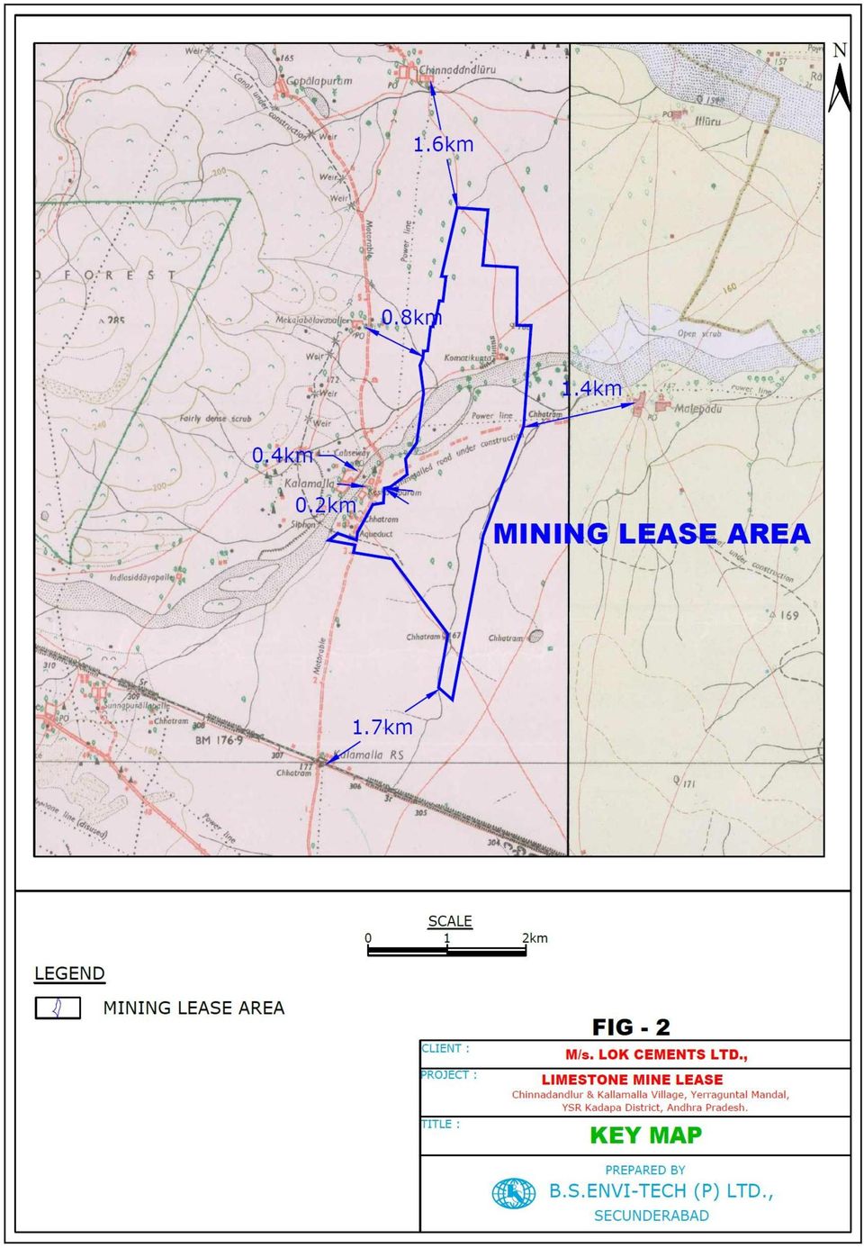
6 CHAPTER 3 PROJECT DESCRIPTION 3.0 PROJECT DESCRIPTION i. Type of project including interlinked and interdependent projects, if any. The proposed project is a limestone mine of 575 ha with production capacity of 3.00 MTPA. Flaggy limestone will be produced and the same will be blended with high grade limestone. Will be used in the existing cement plant. ii. Location (map showing general location, specific location, and project boundary & project site layout) with coordinates. The mining lease area comprising 575 ha is situated at at Chinnadandlur & Kallamalla Villages, Yerraguntla Mandal, Y S R Kadapa District of Andhra Pradesh. The site falls between to East longitude and to North latitude with an average altitude of 175 m above msl. The area is covered in the Survey of India Toposheet nos. 57 J/5, 57 J/6, 57 J/9, 57 J/10 [1:50000 scale]. The location map of the Mining Lease area is shown in Fig 1. Fig 2 shows the Key Map of the Mine site. The area is well connected by road and rail. National Highway - NH- 18 connecting Chittoor Kurnool is at 21.8 km in NE direction to the Mine site. Nearest Railway line connecting Tadpatri to Y.S.R Kadapa of South Central Railway line is at a distance of 1.4 km in Northern direction to the site. Nearest Railway station is Kalamalla is at a distance of 1.7 km in SW to the site. Major Railway station is Y.S.R Kadapa which is at a distance of 50 km in SE to the Mine site. Uppu Vagu is at a distance of 6.7 km in NE direction. Penneru River is at a distance of 2.7 km in NE, with flow from NNW to NE to site. Pageru River is at a distance of 9.4 km in SSE, with flow from SSW to E direction with respect to the site. Pedda Vanka is at a distance of

7 2.8 km in S, with flows within the mine site from W to SE. Mailavaram Cuddapah Right Bank Canal is at a distance of 7.5 km in NW with respect to the mine site. Yerraguntla is the nearest town at 6.6 km in SE to the site. Nearest Settlements from the Mine are as follows Chinnadandluru 1.6 km N Keshavapuram 0.2 km W Kalamalla 0.4 km W Mekalabalavapalle km - W Nearest Reserved Forests: Rameshwaram RF km - ENE Niduzuvvi RF 5.1 km - S Kosinepalle RF km - W There are no wild life sanctuaries, national parks, elephant/tiger reserves within 10-km radius of the study area. Fig - 3 shows the 10 km radius of the study area around Mine site.

8 FIG - 1 LOCATION MAP INDIA ANDHRA PRADESH Srikakulam Vizianagaram Vishakhapatnam East Godavari West Godavari Krishna Guntur Kurnool Prakasam LEGEND DISTRICT BOUNDARY RIVER & CANAL STREAMS Anantapur YSR Kadapa Chittoor SPSR Nellore Y.S.R.KADAPA 18 NATIONAL HIGHWAY STATE HIGHWAY ROAD RAILWAY TRACK DISTRICT HEADQUARTER TALUK HEADQUARTER TOWN MINE SITE Talamanchipatnam Peddapasupula Koduru Jammalamadugu Duvvuru Payalakunta Lavanuru Proddatur Maidukuru Badvel Muddanuru Kondapuram Balapanuru Lingala MINE LEASE AREA Erraguntla Khajipeta Kamalapuram Chennur Gangireddipalle Y.S.R Kadapa Kumbhagiri Pellagiri Obalam Pulivendla Vellaturu Simhadripuram Tanduru Vempalle Polatala Guvvalacheruvu Konapeta Lakkireddipalle Virapalle Rayachoti Kottapeta Galivedu Kalasapadu Porumamilla Maddimadugu Tsundupalle Chinnamandem 18 Nandalur Erraguntlakota Koduru Mudumpadu Tangaturu Penagaluru Rajampet Chitvel Pullampet Mgilipenta Settigunta

9
10

11 Feature Altitude Longitude Latitude Village, Mandal, District, State TABLE - 1 SALIENT FEATURES OF THE MINE SITE. Details Maximum Temperature o C 46.1 Minimum Temperature o C 10.6 Relative Humidity, % Annual rainfall, mm Topography Soil Type Nearest IMD Station Nearest River Nearest Highway Nearest Railway station Nearest Industries Nearest Village Nearest Town Nearest Inter State Boundary Nearest Air port Nearest Forest Historical places 175 m above msl Between to East Between to North Chinnadandlur & Kallamalla Village, Yerraguntla Mandal, Y.S.R.Kadapa district of Andhra Pradesh Plain Clayey YSR Kadapa 44.3 km SE. Penneru River 2.7 km - NE National Highway - NH-18 connecting Chittoor Kurnool is at 21.8 km in NE direction to the Mine site. Kalamalla RS km - SW India Cements Limited (Nidizivve) 5.1 km SE India Cements Limited (Chilamakuru) km - SE Zuari Cements 8.0 km SSE Rayalaseema Thermal Power Station 1.4 km WNW Chinnadandluru 1.6 km N Malepadu 1.4 km - E Chhatram (Kalamalla RS) 1.7 km - SW Keshavapuram 0.2 km W Kalamalla 0.4 km W Mekalabalavapalle km - W Yerraguntla 6.6 km - SE Andhra Pradesh Karnataka 96.5 km SSW, Andhra Pradesh Telangana km - SSE Hyderabad (Shamshabad) Airport km N, Kadapa Airport 36.1 km SE, Bengaluru International Airport km SSW Renigunta Aitrport-163km - SE Rameshwaram RF km - ENE Niduzuvvi RF km - S Kosinepalle RF km - W None Within 10 Km Radius. *all distances mentioned in the above table are aerial distances

12 i. Details of alternate sites considered and the basis of selecting the proposed site, particularly the environmental considerations gone into should be highlighted. No alternate sites were considered as the project is mineral specific. ii. Size or magnitude of operation. Mine area is about 575 ha. The proposed rate of production of limestone is 3.00 MTPA. iii. Project description with process details (a schematic diagram/ flow chart showing the project layout, components of the project etc. should be given) The mining will be opencast mechanized mining, employing DTH drilling for blast holes, after blasting the mineral will be loaded into the tippers using hydraulic excavator. The limestone after crushing to the desired size in the crusher will be transported to the plant by dumpers. The benches shall be of 10 m height with a width of 20 m. The benches shall be sloped at 70 o to 85 0 to the horizontal. Since, the formations are very hard and near horizontal with dip angle between 0 o 3 o, there will not be risk of any slope failures. Drilling Latest hydraulic drills will be used in combination with the dieseloperated compressors. The diameter of drill hole will be of mm diameter. Primary Drilling Bench Height As per the deposit characteristics the bench height will be kept at 10.0 m.
 The mining will be opencast mechanized mining, employing DTH drilling for blast holes, after blasting the mineral will be loaded into the tippers using hydraulic excavator.")
13 Burden 30% to 40% of the bench height i.e. 3.0 m depending on the height of the bench and also depends upon the thickness of individual litho unit. Spacing A spacing of 5.0 m shall be maintained based on nature and stratigraphic sequence of the rock. Angular Holes The blast hole shall be sloped at angle of 10 0 to 15 0 from vertical. Depth of Holes The depth of the hole shall be kept at 8.5 m equal to bench height with sub grade drilling. Secondary Blasting No secondary blasting will be carried out. The boulders will be broken by deploying rock breaker or by using secondary blasting if required. However with the precise method of blasting and adopting the method of decking in between the fractured zone, shall try to avoid the boulder formation. ii) Blasting Blast holes of 115 mm will be drilled and primary blasting will be done by using 83 mm slurry explosives % and ANFO mixture in which 80-85% will be the usage of ANFO mixture. The base booster will be slurry explosive. The blast will be initiated by using Milli Seconds delay detonators and cordtex fuse. The blasting will be carried out using sequential blasting machine/nonel to reduce ground vibration and to control the fly rock.

14 iii) Loading Loading of limestone will be carried out with the help of hydraulic excavators of 1.9 m3 bucket capacity. iv) Hauling Dumpers of 25 tonnes capacity will be used for transport of limestone from pit to crusher. v) Raw material required along with estimated quantity, likely source, marketing area of final product/s, mode of transport of raw material and finished product. No raw material is required. Resource optimization / recycling and reuse envisaged in the project, if any, should be briefly outlined. The top soil/overburden will be used for afforestation development along the lease periphery. Availability of water its source, energy /power requirement Water requirement for the proposed mine is about 200 m3/day for dust suppression, plantation and domestic purposes. This requirement will be supplied by existing pits of other captive Mine-I initially and after formation of the mine pit, rain water collected in the mine pit will be used. The power required for illumination will be supplied from grid iv. Quantity of wastes to be generated (liquid and solid) and scheme for their management / disposal. Waste generation from the mine is about 25.8 million tonnes..this waste will be disposed to the dumps. Wastewater generated from domestic use will be treated in septic tank followed by soak pit.

15 v. Schematic representations of the feasibility drawing which give information of EIA purpose.

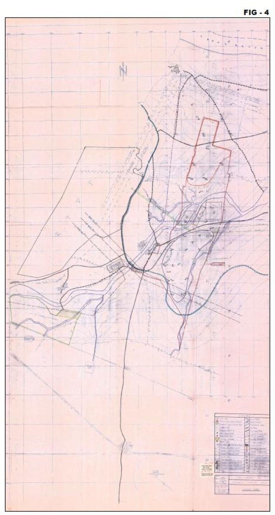
16 CHAPTER 4 SITE ANALYSIS 4.0 Site Analysis i. Connectivity. The National Highway (NH-18) connecting Chittoor Kurnool at 21.8 km in NNE direction. The nearest railway station is kallamalla at 1.7 km in SW direction. Nearest Railway line connecting Tadpatri to Y.S.R Kadapa of South Central Railway line is at a distance of 1.4 km in Northern direction ii. Land form, land use and land ownership. Mining Lease covers an area of 575 Ha. is private patta land About 30 % of the mining lease is under rainfed cultivation. Balance area is with outcrops of limestone and shrubs. Topography (along with map) The mine is an undulated terrain. Map showing the topography is enclosed as Figure 4

17
18 iii. Existing land use pattern (agriculture, non-agriculture, forest, water bodies (including area under CRZ), shortest distances from the periphery of the project to periphery of the forests, national park, wild life sanctuary, eco sensitive areas, water bodies (distance from the HFL of the river), CRZ, in case of notified industrial area, a copy of the Gazette notification should be given. Mining Lease covers an area of 575 Ha. is private patta land About 30 % of the mining lease is under rainfed cultivation. Balance area is with outcrops of limestone and shrubs. One stream passing through the lease area will be suitably diverted to see that the hydrology is not effected. No sensitive areas or National parks are located within 10 km of the mine area. iv. Existing infrastructure. None v. Soil classification The top soil is sand clayey and loamy type. The top soil is covered the entire area with varying thickness (from 0.5m to 1.0m). vi. Climatic data from secondary sources The tropical climate of the region is manifested in hot and humid summer, moderately monsoon and mild winter seasons. May is the hottest month in the year. The maximum temperature during the day time was recorded as C and December the coldest with the temperature during the day time falling down to about 31 0 C. The night temperature in winter can be as low as C. The months of December, January & February are considered to have pleasant climate.

19 vii. Social infrastructure available. Most of the villages are dependent on the ground water sources such as bore well and Tube wells for drinking water purposes. Educational facilities upto primary school only are available in many villages,. Better educational facilities like Secondary schools, ITI, Arts & science college are available in Yerrakuntla. Almost all the villages are electrified. Electricity is used for domestic as well as for agricultural purposes. However, quality of power is poor and there is frequent power fluctuation in this region. There is Primary Health Centers (PHC) in almost all the major rural villages Government Hospital and private clinics are available in Yerrakuntla..

20 CHAPTER 5 PLANINIG BRIEF 5.0 Planning Brief i. Planning concept (type of industries, facilities, transportation etc.) Town and country planning / development authority classification. Not applicable. The subjected mine is the captive limestone mine of over an area of 575 Ha falls under Jurisdiction of Chinnadandlur and Kallamalla Villages, Yerraguntla Mandal, Y S R Kadapa District, Andhra Pradesh. The proposal is for 3.00 MTPA limestone production. ii. Population projection About 85 workers will be deployed. iii. Land use planning (breakup along with greenbelt etc.,) During the life of the mine, about 480ha will be developed into water reservoir, 27ha will be under afforestation and balance area will remain undisturbed. iv. Assessment of infrastructure demand (physical & social ) The mining operations would aid in the overall social and economic development of the region. The mine will give employment to about 85 people, in addition there will be indirect employment to many more people, in the form of contractual jobs, business opportunities, service facilities etc. This will enhance the economic status. v.amenities / Facilities. LCL will provide all the facilities, as required for the mines under Mining Laws, like Rest Shelter,Canteen,Occupational Health centre,vocational training centre etc..
 During the life of the mine, about 480ha will be developed into water reservoir, 27ha will be under afforestation and balance area will remain undisturbed. iv.")
21 CHAPTER 6 PROPOSED INFRASTRUCTURE 6.0 Proposed infrastructure i. Industrial area (processing area) No processing is involved The mine will be operated by means of opencast fully mechanised method of mining which includes deep drilling and blasting, loading the broken material by heavy machinery like hydraulic excavators and tippers for transporting the limestone to crusher at cement plant. ii. Residential area (non-processing area) No residential area is proposed at mine. iii. Green belt. 7.5 m of mine periphery will be under plantation Afforestation will be done covering an area of 27 ha with saplings at the boundary of mine. iv. Social infrastructure. The mining activity carried out in the area rather has a positive socio-economic impact upon the nearby human settlement as indirect employment potential is created due to mining and allied activities in the area. Apart from these, the company promotes health and education awareness in the area time to time by organizing health and education camps.
22 v. Connectivity (traffic and transportation road/ rail/ metro/ water ways etc.,) The Mining Lease area is connected by road National Highway (NH-18) connecting Chittoor -Kurnool Nandyal at 21.8 km in NE direction, The nearest railway station is Kallamalla at 1.7 km in SW direction. Nearest Railway line connecting Tadpatri to Y.S.R Kadapa of South Central Railway line is at a distance of 1.4 km in Northern direction. vi. Drinking water management (source & supply of water) Water requirement for the proposed mine is about 200 m 3 /day. Initially, this water requirement will be met from cement plant and after development of the mine pit, the pit water will be used. vii. Sewerage system Domestic waste water from mines office will be treated in septic tank followed by soak pit. viii. Industrial waste management Not Applicable ix. Solid waste management. Waste generation from mine is million tonnes. Waste will be disposed to dumps The top soil generated will be used for afforestation and bench reclamation. x. Power requirement & supply / source. The power required for illumination will be supplied from Grid
23 CHAPTER 7 REHABILITATION AND RESETTLEMENT (R & R) PLAN 7.0 Rehabilitation and resettlement (R & R) Plan i. Policy to be adopted (central / state) in respect of the project affected persons including home oustees, land oustees and landless labourers (a brief out line to be given). Mining Lease covers an area of 575 Ha. is private patta land About 30 % of the mining lease is under rainfed cultivation. Balance area is with outcrops of limestone and shrubs. The mining activities involve displacement of human settlement. The state R&R policy will be followed in relocating them No public buildings, places, monuments etc., exist within the lease area or in the vicinity. The land oustees will be enumerated and compensation will be paid as per the Govt. Policy
24 CHAPTER 8 PROJECT SCHEDULE & COST ESTIMATES 8.0 Project schedule & Cost Estimates i. Likely date of start of construction and likely date of completion (time schedule for the project to be given). Mine will be started after getting EC, CTE, CTO and all other regulatory clearances. Life of the 3.0 million tonnes per annum for the mineable reserves of 90 million tonnes would be 30years ii. Estimated project cost along with analysis in terms of economic viability of the project. The estimated project cost for the limestone production will be about Rs. 25 Crores.
25 CHAPTER 9 ANALYSIS OF PROPOSAL (FINAL RECOMMENDATIONS) 9.0 Analysis of proposal (Final Recommendations) i. Financial and social benefits with special emphasis on the benefit to the local people including tribal population, if any, in the area. Economic development of the region depends largely upon the nature of activities undertaken in the surrounding region. Corporate development invariably contributes towards acceleration of the process of socio-economic upliftment of the rural society by means of employment, health & study programme, medical camps etc., Employment: Preference will be given for locals for employment based on qualifications & requirement. Medical facilities: Medical facilities will be provided for employee as well as people of nearby villages. Educational facilities: Basic educational and vocational facilities will be provided for the children of employees as well as nearby villages. Infrastructure facilities: Approach roads will be developed at par with mine roads. Additional: The establishment of factory will facilitate additional auxiliary facilities like banking, post office & recreation facilities.
26
27
2. PRE-FEASIBILITY REPORT
 2. PRE-FEASIBILITY REPORT 2.1 Executive Summary The proposed project is Building stone quarry having lease area of 1.214 ha and falls under Category- A as per EIA Notification 2006 and its amendments of
2. PRE-FEASIBILITY REPORT
 2. PRE-FEASIBILITY REPORT 2.1 Executive Summary The proposed project is Building stone quarry having lease area of 0.809 ha and falls under Category- A as per EIA Notification 2006 and its amendments of
PRE- FEASIBILITY STUDY REPORT. M/s. SAI MINERALS
 PRE- FEASIBILITY STUDY REPORT FOR M/s. SAI MINERALS BLACK TRAP MINING (AREA 04-00-00 HECTARE) OF APPLICANT (Mr. AMARJITSINH R. VARACHHIYA) (PARTNER) AT SURVEY NO: 13, AT: ASHNAVI, TAL: JHAGADIA, DIST:
PRE-FEASIBILITY REPORT
 PRE-FEASIBILITY REPORT OF MASONRY STONE (CHEJA PATTHAR) MINING PROJECT (ML Area: 1.0 ha, M.L. No. 65/2011, Production Capacity-1, 11,780 TPA) Near Village: Gangora, Tehsil: Pahari, District: Bharatapur
PRE - FEASIBILITY REPORT
 PRE - FEASIBILITY REPORT FOR OBTAINING PRIOR ENVIRONMENT CLEARANCE TO Building Stone MINING ACTIVITY FOR CATEGORY B3 UNDER THE EIA NOTIFICATION 3006 AMENDED ON 31/05/3013 TO 1.97.58 SHREE SHAH ENGINEERING
PRE- FEASIBILITY STUDY REPORT
 PRE- FEASIBILITY STUDY REPORT FOR RAJNIKANT GORDHANBHAI CHANIYARA PROPOSED BLACK TRAP MINING (AREA 03-00-53 HECTARE) OF APPLICANT (Mr.Rajnikant Gordhanbhai chaniyara) (PAWOR OF ATTORNEY) AT BLOCK NO: 66
Pre- FEASIBILITY REPORT
 Pre- FEASIBILITY REPORT In Respect Of JHILIMINDA SAND BED OVER 20.30 ACRES OR 8.215 HA IN VILLAGE JHILIMINDA, ATTABIRA TAHASIL OF BARGARH DISTRICT, ODISHA (For the Financial Year-2015-16 to 2019-20) Prepared
Pre- FEASIBILITY REPORT
 Pre- FEASIBILITY REPORT In Respect Of SRIPURA SAND BED-BOVER 35.25 ACRES OR 14.265 HA IN VILLAGE SRIPURA, JHARSUGUDA TAHASIL OF JHARSUGUDA DISTRICT, ODISHA (For the Financial Year-2015-16 to 2019-20) Prepared
PRE FEASIBILITY REPORT
 PRE FEASIBILITY REPORT for PROPOSED PROJECT FOR SOIL MINING of M/s. BHAVINKUMAR VINODBHAI LAD SURVEY NO. 98, MOJE ANCHELI, TAL. BARDOLI, DIST. SURAT, GUJARAT 1 CONTENTS Sr. Description Page No. No. 1.
PRE FEASIBILITY REPORT
 PRE FEASIBILITY REPORT FOR M/S. AMRUT STONE QUARRY (AREA 2.57 HECTARE) OF APPILCANT MR. RAJNIKANT BHAGWANJIBHAI KATHIRIYA (Partner) AT BLOCK NO: 98,VILL: ZAB, TAL: MANDVI, DIST: SURAT 394163 GUJARAT. 1
PRE FEASIBILITY REPORT
 PRE FEASIBILITY REPORT In Respect Of MAHUMUHAN STONE MINE 9 OVER 2.00 ACRES (0.81 HECTARE) IN VILLAGE MAHUMUHAN, SORO TAHASIL OF BALASORE DISTRICT, ODISHA (FOR THE PERIOD: 2015 16 TO 2019 20) APPLICANT
M/s. Karshanbhai Bhagvanbhai Rabari
 PRE FEASIBILITY REPORT FOR M/s. Karshanbhai Bhagvanbhai Rabari Black TRAP MINING (AREA 1.00 HECTARE) OF APPLICANT Mr. Karshanbhai Bhagvanbhai Rabari (Proprietor) AT Survey No. 194 Paikee, Vill: Thoriyali,
PRE- FEASIBILITY REPORT
 PRE- FEASIBILITY REPORT Applicant: M/s Regaliya Minerals Pvt. Ltd. Page 0 1.0 EXECUTIVE SUMMARY This mining project falls under Category A (presence of interstate boundary between Haryana and Rajasthan
Project Details- Minor Minerals (Other Than Sand)
") Project - Minor Minerals (Other Than Sand) Sr. ABOUT THE PROPOSAL 1. Name of Lease Holder M/s. KARMANBHAI JODHABHAI RABARI (Partner) 2. Location address Mr. Karmanbhai Jodhabhai Rabari Survey No- 194 Paikee,
Project - Minor Minerals (Other Than Sand) Sr. ABOUT THE PROPOSAL 1. Name of Lease Holder M/s. KARMANBHAI JODHABHAI RABARI (Partner) 2. Location address Mr. Karmanbhai Jodhabhai Rabari Survey No- 194 Paikee,
CONTENT LIST PRE-FEASIBILITY REPORT S. NO. CONTENTS PAGE NO. 1.0 EXECUTIVE SUMMARY 1
 CONTENT LIST PRE-FEASIBILITY REPORT S. NO. CONTENTS PAGE NO. 1.0 EXECUTIVE SUMMARY 1 2.0 INTRODUCTION OF THE PROJECT/ BACKGROUND INFORMATION 3 (i) IDENTIFICATION OF PROJECT & PROJECT PROPONENT 3 (ii) BRIEF
Pre- FEASIBILITY REPORT
 Pre- FEASIBILITY REPORT In Respect Of SARANKOTE STONE QUARRY OVER 2.40 ACRES OR 0.971 HA IN VILLAGE SARANKOTE, BARKOTE TAHASIL OF DEOGARH DISTRICT, ODISHA (For the Financial Year-2015-16 to 2019-20) Prepared
Pre-feasibility Report
 1.0 INTRODUCTION EXECUTIVE SUMMARY Balanga Sand Bed over an area of 12.50Ac./5.06Ha. of, Sri Nilamani Behera is located in village Uthaninuagaon, under Tahasil- Badasahi in Mayurbhanj district of Odisha.
Pre- FEASIBILITY REPORT
 Pre- FEASIBILITY REPORT In Respect Of KAIPADAR NEW BUILDING STONE QUARRY (GA) OVER 2.50 ACRES OR 1.00 HA IN VILLAGE KAIPADAR, KHURDA TAHASIL OF KHURDA DISTRICT, ODISHA (For the Financial Year-2015-16 to
Project Details- Minor Minerals (Other Than Sand)
") Project - Minor Minerals (Other Than Sand) Sr. ABOUT THE PROPOSAL 1. Name of Lease Holder M/s. ABDUL MUNAF MOHAMMEDMIYA MALEK Mr.Abdul Munaf Mohammedmiya malek (Proprietor) 2. Location address OPP Block
Project - Minor Minerals (Other Than Sand) Sr. ABOUT THE PROPOSAL 1. Name of Lease Holder M/s. ABDUL MUNAF MOHAMMEDMIYA MALEK Mr.Abdul Munaf Mohammedmiya malek (Proprietor) 2. Location address OPP Block
Pre- FEASIBILITY REPORT
 Pre- FEASIBILITY REPORT In Respect Of KAIPADAR NEW BUILDING STONE QUARRY (KHA) OVER 7.50 ACRES OR 3.00 HA IN VILLAGE KAIPADAR, KHURDA TAHASIL OF (For the Financial Year-2015-16 to 2019-20) Prepared on
Pre- FEASIBILITY REPORT
 Pre- FEASIBILITY REPORT In Respect Of (For the Financial Year-2015-16 to 2019-20) Prepared on Behalf of SRI ANTARYAMI BISWAL Chhend, Rourkela, Dist-Sundargarh, Odisha PREPARED BY The Techno Chamber, Plot
PRE FEASIBILITY REPORT
 PRE FEASIBILITY REPORT ON NAFRI STONE QUARRY NO.2 (IN MAYURBHANJ DISTRICT OF ODISHA) Lease Area: 4.97 acres or 2.01 Ha. of Sri Shyamsundar Bhattar & Others Baripada EXECUTIVE SUMMARY CHAPTER 1 Nafri Stone
Project Details-Minor Minerals (Other Than Sand)
") Project Details-Minor Minerals (Other Than Sand) Sr. No. Details Particulars ABOUT THE PROPOSAL 1. Name Of lease Holder M/s. Kirtikumar Samji Sengani 23 0'27.43"N 69 24'10.21"E 2. Location address Survey
Project Details-Minor Minerals (Other Than Sand) Sr. No. Details Particulars ABOUT THE PROPOSAL 1. Name Of lease Holder M/s. Kirtikumar Samji Sengani 23 0'27.43"N 69 24'10.21"E 2. Location address Survey
PRE FEASIBILITY REPORT & ENVIRONMENT MANAGEMENT PLAN
 PRE FEASIBILITY REPORT & ENVIRONMENT MANAGEMENT PLAN Of COLOUR GRANITE MINE 1.000 HA SURVEY NO: 186/1 OF KUPPIGANIPALLI VILLAGE, GUDUPALLI MANDAL, CHITTOOR DISTRICT, ANDHRA PRADESH. Proposed By M/s. SREE
Form -1 Mining Plan & Pre-feasibility Report
 Form -1 Mining Plan & Pre-feasibility Report FOR QUARRYING OF GREY GRANITE (EXTENT 1.8.0Ha)-B2 PROJECT S.F.Nos 35/2D, 35/3, 35/2E (P)& 3/1A1 (P) Village Chendarapalli Taluk Krishnagiri District Krishnagiri
ENVIRONMENT MANAGEMENT PLAN
 ENVIRONMENT MANAGEMENT PLAN OF M/s Baghel Infrastructure Pvt. Ltd. AT Khasra No 1203/1 Vill- Makrohar, Tehsil-Mada, District-Singrauli (M.P.) Production Capacity: 8158Cu.mt/year Metal Stone Area 1.00 Hectare
NIMAPALLI STONE QUARRY
 EIA/ EMP NIMAPALLI STONE QUARRY Village : Nimapalli Tahasil : Purushottampur State : Odisha Lease Area - 4.046 Ha Screening Category B2 SRI SANJAY KUMAR NAYAK At- Pallyama, Dist : Ganjam (Odisha) CONTENTS
FORM -1 MINING PLAN & PRE-FEASIBILITY REPORT. FOR QUARRYING OF ROUGH STONE (Extent: 3.00.0Ha)-B2 Project
-B2 Project") FORM -1 MINING PLAN & PRE-FEASIBILITY REPORT FOR QUARRYING OF ROUGH STONE (Extent 3.00.0Ha)-B2 Project!!"# $%&'( )!*+ $*, % -!#( # )(!&.* /012 3345 36 7898 ;?DGGMN
FORM -1 MINING PLAN & PRE-FEASIBILITY REPORT FOR QUARRYING OF ROUGH STONE (Extent 3.00.0Ha)-B2 Project!!"# $%&'( )!*+ $*, % -!#( # )(!&.* /012 3345 36 7898 ;?DGGMN
PRE FEASIBILITY REPORT
 PRE FEASIBILITY REPORT 19 1. EXECUTIVE SUMMARY This is a mining project proposal of obtaining Environmental Clearance for Slate Stone with production Capacity 7500 TPA (ROM), Near Village: Anandpura, Tehsil:
How To Conduct An Environmental Impact Assessment
 Proposed Terms of Reference for EIA studies 1. Introduction The proposed expansion of Bulk Drugs & Intermediates manufacturing unit by M/s. Sri Krishna Pharmaceuticals Limited (Unit V). is located at Plot
ENVIRONMENT MANAGEMENT PLAN
 ENVIRONMENT MANAGEMENT PLAN ENVIrONMENT MaNaGEMENT plan 1. INTRODUCTION: Shri Ratilal Ravji Solanki have a Blacktrap mining lease project for an area of 1.00.00 Ha located on Survey no. 984 paiki, Village:
ENVIRONMENT MANAGEMENT PLAN
 6. REHABILITATION AND RESETTLEMENT (R & R) PLAN Since the project is private land, there is no reserves forest or protected forest land within the applied area. There is no human settlements within the
2x800 MW Thermal Power Project Near Village Paraspani, Tehsil Pathargama, Godda- District By Adani Power (Jharkhand) Limited
 Limited") (IV) Proposed Terms of Reference for EIA Studies Project Category Project Proponent Location Paraspani Thermal Power Plant (2x800 MW) Coal based Thermal Power Project A [1(d) Thermal Power Plant 500 MW]
(IV) Proposed Terms of Reference for EIA Studies Project Category Project Proponent Location Paraspani Thermal Power Plant (2x800 MW) Coal based Thermal Power Project A [1(d) Thermal Power Plant 500 MW]
Form -1 Mining Plan & Pre-feasibility Report
 Form -1 Mining Plan & Pre-feasibility Report TO OBTAIN ENVIRONMENTAL CLEARANCE FOR QUARRYING OF BLACK GRANITE (DOLERITE) (EXTENT 2.81.0Ha)-B2 PROJECT IN S.F.Nos 9,80,258/2B,258/6A & 258/6B Village Naduvanapalli
ENVIRONMENT MANAGEMENT PLAN
 ENVIRONMENT MANAGEMENT PLAN OF Shri Kuldeep Choudhary AT Khasra No.Part of 112 Vill.-Golpura, Tehsil-Gandhwani, District-Dhar (M.P.) Production Capacity: 4543 Cu.mt/year Basalt Stone&4543 Cu.mt/year Murram
Pre Feasibility Report
 Pre Feasibility Report On Proposed to install 4.0 MTPA Coal Washery At Survey No. 83/2, 14, 15, 23, 24, 26 31 Mouza Sasti (Panderpauni) Tahsil Rajura, District Chandrapur. Submitted to MINISTRY OF ENVIRONMENT,
ENVIRONMENT MANAGEMENT PLAN
 ENVIRONMENT MANAGEMENT PLAN FOR VILLAGE TEHSIL DISTRICT AREA MINERAL : Makrohar : Mada : Singrauli (M.P.) : 1.00 hect : Metal Stone KHASRA No : 176,178 PRODUCTION CAP : 15375 Cu.mt/year Metal Stone APPLICANT
PRE FEASIBILITY REPORT
 PRE FEASIBILITY REPORT PATHARPUNJI STONE QUARRY (PLOT-14) Village: Patharpunji Tahasil: Sheragada, District: Ganjam, State: Odisha Lease Area 1.080 Ha Screening Category B2 Sri Ramesh Swain S/o-Charan
PRE-FEASIBILITY REPORT
 PRE-FEASIBILITY REPORT S. NO. CONTENTS PAGE NO. 1.0 EXECUTIVE SUMMARY 1.1 ENVIRONMENTAL MANAGEMENT PLAN 2 1.1.1 AIR QUALITY MANAGEMENT 2 1.1.2 WATER QUALITY MANAGEMENT 2 1.1.3 NOISE QUALITY MANAGEMENT
Environment Management Plan
 Environment Management Plan FOR Quarry Lease of Crusher Stone Area 1.437Hectare, Kh. No. 40/8 KA AT Village: BHAWANDA, Tehsil: SEONI MALWA Distt HOSHANGABAD (M. P.) Proponent M/S JYORI CONSTRUCTION COMPANY
PRE-FEASIBILITY REPORT
 PRE-FEASIBILITY REPORT FOR QUARRYING ROUGH STONE Over an Extent of 0.34.8 Hectares in S.F. No. 22/5A (Patta Land) in Kachchirayanpatti Village, Melur Taluk, Madurai District & Tamil Nadu State 1. EXECUTIVE
ENVIRONMENT MANAGEMENT PLAN
 ENVIRONMENT MANAGEMENT PLAN Page 33 ENVIRONMENT MANAGEMENT PLAN BLACK TRAP 1.0. INTRODUCTION: The proposed M/s. Black Trap Mine of Govindbhai Karshanbhai Ram area at near Vill.Chuldi, Tal.Malia-Hatina,
ENVIRONMENT MANAGEMENT PLAN
 ENVIRONMENT MANAGEMENT PLAN 1 [Type the company name] ENVIRONMENT MANAGEMENT PLAN LIMESTONE (BUILDING) 1.0. INTRODUCTION: The proposed M/s. Building Lime Stone Mine of Shree Jitubhai Parbatbhai Chudashma
NUAGADA STONE QUARRY Village: Nuagada,Tahasil: Hinjilicut,District: Ganjam, State: Odisha
 PRE FEASIBILITY REPORT NUAGADA STONE QUARRY Village: Nuagada,Tahasil: Hinjilicut,District: Ganjam, State: Odisha Sri Kailash Chandra Goud At-Sompur PO- Hinjilicut Dist: Ganjam (Odisha) Chapter -1 1.1 EXECUTIVE
CHANDAM7AIL,P SAND DEPOSIT
 1 RVER SAND QUARRY 11 ENVRONMENT MANEGMENT PLAN OF CHANDAM7AL,P SAND DEPOST VLLAGE- GHAWDAWAL, TEHSHL- LAltEAR DSTRCT- BMTUD, STATE- MADHYA PRADESH (MASRL4 NO- 1, 10, 15, AREA- 5.975 Hectare APPLCANT Sub
ENVIRONMENTAL MANAGEMENT PLAN
 ENVIRONMENTAL MANAGEMENT PLAN CONTENTS OF ENVIRONMENTAL MANAGEMENT PLAN Chapter Title Page No. 1. INTRODUCTION 1-4 2. PROJECT PROPONENT 1 2.1 Project Location and Accessibility 1 2.2 Infrastructure and
Project Name: Nangal (M.L. No. 134/03) Masonary Stone Mine PRE- FEASIBILITY REPORT
 Masonary Stone Mine PRE- FEASIBILITY REPORT") PRE- FEASIBILITY REPORT 1.0 EXECUTIVE SUMMARY 1.1 Executive Summary The proposed mining project falls under Category A Project or activity 1(a) as per EIA Notifications 2006 and amended thereof due to
PRE- FEASIBILITY REPORT 1.0 EXECUTIVE SUMMARY 1.1 Executive Summary The proposed mining project falls under Category A Project or activity 1(a) as per EIA Notifications 2006 and amended thereof due to
Environment Management Plan
 Environment Management Plan FOR Mining of Crusher Stone Area 2.000 Hectare, Khasra No. 42/2 Village AT THANWARI Tehsil District State SEONI SEONI MADHYA PRADESH Proponent SHRI LAKHAN LAL S/O SHRI CHETAN
EnVirOnMEnT ManaGEMEnT PLan. FOr. M/S. LiME STOnE MinE OF. Dhirajlal Panchanbhai Vachhani. area. PrOPOSEd PrOdUCTiOn:-36000 TPa
 EnVirOnMEnT ManaGEMEnT PLan FOr M/S. LiME STOnE MinE OF dhirajlal PanChhanBhai VaChhani area (SUrVEY no.49 PaiKi, ViLL.Unadari, TaL.Una, dis.junagadh) PrOPOSEd PrOdUCTiOn:-36000 TPa PrOJECT COST: - 15
INDEX 1.0 EXECUTIVE SUMMARY... 23
 INDEX 1.0 EXECUTIVE SUMMARY... 23 2.0 INTRODUCTION OF THE PROJECT/ BACKGROUND INFORMATION 24 2.1 IDENTIFICATION OF PROJECT AND PROJECT PROPONENT... 24 2.2 BRIEF DESCRIPTION OF THE NATURE OF PROJECT...
ENVIRONMENTAL MANAGEMENT PLAN
 ENVIRONMENTAL MANAGEMENT PLAN Of M/s. D.BHARATHI 11.76 Acres Silica Sand Mine, Sy.No. 44/3,50/4,50/5&50/6 ADDEPALLI (V), CHILLAKUR (M), SPSR NELLORE DISTRICT ANDHRA PRADESH Prepared by SV ENVIRO LABS &
ENVIRONMENT MANAGEMENT PLAN
 ENVIRONMENT MANAGEMENT PLAN FOR VILLAGE TEHSIL DISTRICT AREA MINERAL : Kothi : Pawai : Panna (M.P.) : 1.370 Hectare : Flagstone KHASRA No : 31 PRODUCTION CAP : Max 875 Cu.mt/year Flagstone APPLICANT Shri
Environment Management Plan
 Environment Management Plan FOR Mining of Agariya Crusher stone Quarry Area-4.00,Hectare Kh No-141/3/1,141/4,141/5 At Village- Agariya, Tehsil: Gouharganj Distt. Raisen SHRI. ASHOK SHARMA S/O SHRI GANGAPRASAD
Proposed Terms of Reference for EIA studies
 1 Proposed Terms of Reference for EIA studies Base line data collection will be collected for the Post-Monsoon season 2016 (September to November 2016) in study area and 10 kms radius from project site.
ENVIRONMENT MANAGEMENT PLAN
 ENVIRONMENT MANAGEMENT PLAN LIMESTONE 1. INTRODUCTION: The proposed Bagdhara Limestone area, near Village- Bagdhara, Taluka- Jamjodhpur and District-Jamnagar, Gujarat has been granted to Dipakkumar Anantray
ENVIRONMENTAL MANAGEMENT PLAN
 Of MINING OF BLACK GRANITE 1.0 HA SURVEY NO: 38/11 OF CHINNAGANDLAPALLI VILLAGE, SANTHIPURAM MANDAL, CHITTOOR DISTRICT, ANDHRA PRADESH. By M/s. EVERSHINE GRANITILES LAKSHMIPURAM, KUPPAM, CHITTOOR, ANDHRA
ENVIRONMENTAL MANAGEMENT PLAN
 ENVIRONMENTAL MANAGEMENT PLAN Of M/s. SRINIVASA GRANITES 5.010 HA COLOUR GRANITE MINING SY. NO. 539/B & 546/P UPPAMAGULUR (V), BALLIKURAVA (M) PRAKASAM (DT), ANDHRA PRADESH Submitted by SV ENVIRO LABS
TERMS OF REFERENCE FOR SCOPING OF EIA STUDY
 TERMS OF REFERENCE FOR SCOPING OF EIA STUDY Ours project is a proposed large scale unit and categorized as 5(h)-B as per the EIA notification 2006 of MoEFCC, New Delhi and subsequent amendments. Looking
PROPOSED TERMS OF REFERENCE
 PROPOSED TERMS OF REFERENCE ABOUT THE PROJECT: Rampura Marble Mine (ML No.- 420/91) is proposed by M/s Continental Minerals Pvt. Ltd. The Mine Lease area consists of 3.0 ha, which is located at Khasra
Environment Management Plan
 Environment Management Plan FOR Mining of Sildhara Flage Stone Quarry Area-.1.50,Hectare Kh No-87 At Village- Sildhara, Tehsil Panna, Distt.Panna MR.BRIJMOHAN SINGH S/O SHRI JAI RAM SINGH RESI-VILLAGE
PRE FEASIBILITY REPORT
 PRE FEASIBILITY REPORT. 23 TABLE OF CONTENT Sr. No. Content Page No. 1.0 Executive Summary 25 2.0 Introduction of Project and Background Information 26 3.0 Project Description 28 4.0 Site Analysis 33 5.0
Project Name: Chanawda & Bijasna (M.L. No. 209/09) Masonary Stone PRE- FEASIBILITY REPORT
 Masonary Stone PRE- FEASIBILITY REPORT") Project Name: Chanawda & Bijasna (M.L. No. 209/09) Masonary Stone PRE- FEASIBILITY REPORT 1.0 EXECUTIVE SUMMARY 1.1 Executive Summary The proposed mining project falls under Category A Project or activity
Project Name: Chanawda & Bijasna (M.L. No. 209/09) Masonary Stone PRE- FEASIBILITY REPORT 1.0 EXECUTIVE SUMMARY 1.1 Executive Summary The proposed mining project falls under Category A Project or activity
LORE SILICA SAND MIINE
 PRE FEASIBILITY REPORT OF Submitted to MINISTRY OF ENVIRONMENT, FORESTS & CLIMATE CHANGE GOVT. OF INDIA Paryavaran Bhawan, CGO Complex Jor Bagh Road, New Delhi-110 003 LORE SILICA SAND MIINE Village: Lore,
GPS BASED TRUCK DISPATCH SYSTEM (TDS) IN HIGHLY MECHANIZED BAUXITE MINES A CASE STUDY.
 IN HIGHLY MECHANIZED BAUXITE MINES A CASE STUDY.") GPS BASED TRUCK DISPATCH SYSTEM (TDS) IN HIGHLY MECHANIZED BAUXITE MINES A CASE STUDY. Dr Ashutosh Roul, PhD Senior Manager(Mines),NALCO. NALCO Asia s largest integrated Aluminium Complex, Encompassing
GPS BASED TRUCK DISPATCH SYSTEM (TDS) IN HIGHLY MECHANIZED BAUXITE MINES A CASE STUDY. Dr Ashutosh Roul, PhD Senior Manager(Mines),NALCO. NALCO Asia s largest integrated Aluminium Complex, Encompassing
Pre-Feasibility Report for ITC Mixed Use Development, Rajarhat, Kolkata
 Pre-Feasibility Report for ITC Mixed Use Development, Rajarhat, Kolkata 1 Introduction of the Project About ITC ITC is one of India's foremost multi-business enterprise with a market capitalization of
Proposed Terms of Reference for EIA studies
 Proposed Terms of Reference for EIA studies 1(a): STANDARD TERMS OF REFERENCE FOR CONDUCTING ENVIRONMENT IMPACT ASSESSMENT STUDY FOR NON-COAL MINING PROJECTS AND INFORMATION TO BE INCLUDED IN EIA/EMP REPORT
Fauna- No particular type of fauna finds except snakes, hynus & Jackals, wild cat, wildhen etc. are found in and around the area.
 Environmental Management Plan Baseline information Topography:- The general slope of the area is towards east and gently sloping from 25 0 to 30 0 except southern part which is sloping towards south The
The Terms of reference (ToR) for conducting Rapid EIA study for the proposed project is described below:
 for conducting Rapid EIA study for the proposed project is described below:") Proposed Terms of Reference for EIA Study Objective: In order to identify the environmental impacts due to construction and operation of the proposed project and associated facilities, a study will be
Proposed Terms of Reference for EIA Study Objective: In order to identify the environmental impacts due to construction and operation of the proposed project and associated facilities, a study will be
PRE-FEASIBILITY REPORT
 PRE-FEASIBILITY REPORT FOR PROPOSED EXPANSION OF EXISTING ASBESTOS CEMENT SHEETS & ACCESSORIES PRODUCTION FROM 72000 TPA TO 175000 TPA OF Limited JASIDIH Dist.: Deoghar 814 142 (Jharkhand) INDEX Contents
Project Name: Chinawda (M.L. No. 276/03) Masonary Stone Mine PRE- FEASIBILITY REPORT
 Masonary Stone Mine PRE- FEASIBILITY REPORT") PFR PRE- FEASIBILITY REPORT 1.0 EXECUTIVE SUMMARY 1.1 Executive Summary The proposed mining project falls under Category A Project or activity 1(a) as per EIA Notifications 2006 and amended thereof due
PFR PRE- FEASIBILITY REPORT 1.0 EXECUTIVE SUMMARY 1.1 Executive Summary The proposed mining project falls under Category A Project or activity 1(a) as per EIA Notifications 2006 and amended thereof due
ENVIRONMENTAL MANAGEMENT PLAN :-
 ENVIRONMENTAL MANAGEMENT PLAN :- The Environment Management Plan (EMP) is required to ensure sustainable development in the area of the proposed project. Hence it needs to be all encompassive plan for
ENVIRONMENTAL MANAGEMENT PLAN
 ENVIRONMENTAL MANAGEMENT PLAN Of M/s. MARAM VENKA REDDY GRANITES 2.077 HA COLOUR GRANITE MINING SY. NO. 103/P (USH-VEERLAKONDA) KONIDENA (V), BALLIKURAVA (M) PRAKASAM (DT), ANDHRA PRADESH Submitted by
Near Village- Gorir (Modi Pahari), Tehsil Khetri, District Jhunjhunu (Rajasthan) Pre- Feasibility Report
, Tehsil Khetri, District Jhunjhunu (Rajasthan) Pre- Feasibility Report") PRE FEASIBILITY REPORT 1. EXECUTIVE SUMMARY This is an proposed mine. Proposal of obtaining Environmental Clearance for masonry stone with production Capacity 1,00,260TPA (ROM), Near Village: Gorir (Modi
PRE FEASIBILITY REPORT 1. EXECUTIVE SUMMARY This is an proposed mine. Proposal of obtaining Environmental Clearance for masonry stone with production Capacity 1,00,260TPA (ROM), Near Village: Gorir (Modi
BASIC CHECKLIST REQUIRED FOR SUBMISSION OF APPLICATION PARTICULARS
 2 BASIC CHECKLIST REQUIRED FOR SUBMISSION OF APPLICATION SR. NO. PARTICULARS YES/ NO Page no. 1 2 3 Is the application contain covering letter by the project proponent addressed to Member Secretary, SEIAA?
Environmental Management Plan
 Environmental Management Plan FOR BOULDER, GRAVEL AND SAND MINOR MINERAL Mine lease area: 13.20 Ha Village Mandlai Tehsil Raipur Rani, District- Panchkula and State - Haryana Category of Project: B2 Lease
Ratdi Limestone (Building) Mine Location Near Village- Ratdi, Taluka & district Porbandar, (Gujarat) Latitude. 9.0m RL.
 Mine Location Near Village- Ratdi, Taluka & district Porbandar, (Gujarat) Latitude. 9.0m RL.") PRE-FEASIBILITY REPORT 1. EXECUTIVE SUMMARY: Particulars Details Project Name Ratdi Limestone (Building) Mine Location Near Village- Ratdi, Taluka & district Porbandar, (Gujarat) Latitude 21 0 73 73.4
PRE-FEASIBILITY REPORT 1. EXECUTIVE SUMMARY: Particulars Details Project Name Ratdi Limestone (Building) Mine Location Near Village- Ratdi, Taluka & district Porbandar, (Gujarat) Latitude 21 0 73 73.4
Form 1 as per EIA Notification 2006 for Meyyur Rough Stone Quarry of Thiru.N.Suresh Meyyur Village, Tiruvannamalai Taluk and District and Tamilnadu
 Form 1 as per EIA tification 2006 for Meyyur Rough Stone Quarry of Thiru.N.Suresh Meyyur Village, Tiruvannamalai Taluk and District and Tamilnadu Application Form for Obtaining Environmental Clearance
PREFEASIBILITY REPORT
 PREFEASIBILITY REPORT TABLE OF CONTENTS Sr. Content Page No. No. 1.0 Executive Summary 24 2.0 Introduction of Project / Background Information 25 3.0 Project Description 27 4.0 Site Analysis 34 5.0 Planning
Mineral Granite. Lease Area-1.6884. Near Villages- Chandma. Tehsil - Sarwar. District- Ajmer. (Rajasthan) PROJECT PROPONENT
 PROJECT PROPONENT") PREFEASIBILITY REPORT Mineral Granite Mining project- Category B 2 Lease Area-1.6884 Ha. Near Villages- Chandma Tehsil - Sarwar District- Ajmer (Rajasthan) PROJECT PROPONENT SHRI SHANKAR LAL SAHU S/O Shri
PREFEASIBILITY REPORT Mineral Granite Mining project- Category B 2 Lease Area-1.6884 Ha. Near Villages- Chandma Tehsil - Sarwar District- Ajmer (Rajasthan) PROJECT PROPONENT SHRI SHANKAR LAL SAHU S/O Shri
STANDARD TEMPLATE FORM-1 PRE- FEASIBILITY REPORT ENVIRONMENT MANAGEMENT PLAN & MINING PLAN. COLOUR GRANITE QUARRY (QUARRY LEASE AREA: 1.00 ha.
 STANDARD TEMPLATE FORM-1 PRE- FEASIBILITY REPORT ENVIRONMENT MANAGEMENT PLAN & MINING PLAN For COLOUR GRANITE QUARRY (QUARRY LEASE AREA: 1.00 ha.) At SY. NO.266 OF HAVALIGI VILLAGE, VIDAPANAKAL MANDAL,
 Pre-Feasibility Report For Building Stone Quarry Of M/s G T B Enterprises At Sy No: 23, Thammanayakanahally Village, Anekal Taluk, Bengaluru District, Karnataka (Extent- 4-00 Acre) Pre-Feasibility Report
PRE-FEASIBILITY REPORT
 PRE-FEASIBILITY REPORT OF MASONRY MINING PROJECT (M.L. No. 107/02, ML Area: 1.0 ha) At Near Village-Banar Tehsil- Kotputli District - Jaipur (Raj.) PROJECT PROPONENT R/o Navratan Apartment, Plot No. 7A,
No. J-11015/290/2013-IA.II(M) GOVERNMENT OF INDIA MINISTRY OF ENVIRONMENT AND FORESTS IA-II (Coal-Mining) Division
 GOVERNMENT OF INDIA MINISTRY OF ENVIRONMENT AND FORESTS IA-II (Coal-Mining) Division") No. J-11015/290/2013-IA.II(M) GOVERNMENT OF INDIA MINISTRY OF ENVIRONMENT AND FORESTS IA-II (Coal-Mining) Division Paryavaran Bhawan CGO Complex, Lodhi Road New Delhi- 110 003 To The Managing Director
No. J-11015/290/2013-IA.II(M) GOVERNMENT OF INDIA MINISTRY OF ENVIRONMENT AND FORESTS IA-II (Coal-Mining) Division Paryavaran Bhawan CGO Complex, Lodhi Road New Delhi- 110 003 To The Managing Director
PROPOSED TERMS OF REFERENCE
 Annexure-IV PROPOSED TERMS OF REFERENCE 1.0 Proposed Scope of Work for EIA Study The components of the EIA study include: Detailed description of all elements of the project activities (existing and proposed
Application Form for Obtaining Environmental Clearance from State Level Environment Impact Assessment Authority (SEIAA) Tamilnadu
 Tamilnadu") Form 1 as per EIA tification 2006 for Vengadampatti Part-2 Rough Stone, Jelly and Gravel Quarry of Tmt. B.Lakshmi Rajam, Vengadampatti Part-2 Village, Alangulam Taluk, Tirunelveli District and Tamilnadu
Form 1 as per EIA tification 2006 for Vengadampatti Part-2 Rough Stone, Jelly and Gravel Quarry of Tmt. B.Lakshmi Rajam, Vengadampatti Part-2 Village, Alangulam Taluk, Tirunelveli District and Tamilnadu
APPLICATION (FORM-1, PRE-FEASIBILITY REPORT)
") APPLICATION (FORM-1, PRE-FEASIBILITY REPORT) ENVIRONMENTAL CLEARANCE FOR STONE MINE (MINING LEASE AREA 0.40 Ha) AT Gut. 39, Village- Warkhed (Khurd), Tehsil- Shegaon, District- Buldhana, State-Maharashtra
APPLICATION (FORM-1, PRE-FEASIBILITY REPORT) ENVIRONMENTAL CLEARANCE FOR STONE MINE (MINING LEASE AREA 0.40 Ha) AT Gut. 39, Village- Warkhed (Khurd), Tehsil- Shegaon, District- Buldhana, State-Maharashtra
TERMS OF REFERENCE. BEFORE CONSTRUCTION: Sl No TOR RESPONSE 1. Legalities of the land: Is the land The Project is clear from all angles.
 TERMS OF REFERENCE Name of the Project: M/s Suadela Constructions Pvt. Ltd. Address: Sy.No. 321/2B(P),321/2C(P),322/1,323/1(P),323/1(P),323/3,323/4,323/5(P), 323/6,323/7,325/1(P),325/2,327,328/1,328/2(P),328/3,328/4,330,331,332/2
(IV) Proposed Terms of Reference for EIA Studies
 Proposed Terms of Reference for EIA Studies") ENVIRONMENT CLERNCE FOR EXPNSION OF 1X600 MW SUPER CRITICL THERML POWER PLNT BY DDITION 2X800 MW UNIT (PHSE II) IN RIGRH DISTRICT IN CHHTTISGRH STTE (IV) Proposed Terms of Reference for EI Studies Project
ENVIRONMENT CLERNCE FOR EXPNSION OF 1X600 MW SUPER CRITICL THERML POWER PLNT BY DDITION 2X800 MW UNIT (PHSE II) IN RIGRH DISTRICT IN CHHTTISGRH STTE (IV) Proposed Terms of Reference for EI Studies Project
STANDARD TEMPLATE, FORM I, PRE-FEASIBILITY REPORT AND ENVIRONMENTAL MANAGEMENT PLAN FOR ENVIRONMENTAL CLEARANCE
 STANDARD TEMPLATE, FORM I, PRE-FEASIBILITY REPORT AND ENVIRONMENTAL MANAGEMENT PLAN FOR ENVIRONMENTAL CLEARANCE OF THE PROPOSED COLOUR GRANITE MINING PROJECT APPLICATION. AT SURVEY NO. 54/P,2.0 HECTARE
THE NATURAL RESOURCES AND ENVIRONMENT ORDINANCE (CAP. 84 - LAWS OF SARAWAK, 1958 Ed.)
") THE NATURAL RESOURCES AND ENVIRONMENT ORDINANCE (CAP. 84 - LAWS OF SARAWAK, 1958 Ed.) THE NATURAL RESOURCES AND ENVIRONMENT (PRESCRIBED ACTIVITIES) ORDER, 1994 (Made under section 11A(1)) (Incorporating
THE NATURAL RESOURCES AND ENVIRONMENT ORDINANCE (CAP. 84 - LAWS OF SARAWAK, 1958 Ed.) THE NATURAL RESOURCES AND ENVIRONMENT (PRESCRIBED ACTIVITIES) ORDER, 1994 (Made under section 11A(1)) (Incorporating
Exploration for natural gas
 FACT SHEET NO. 42 Exploration for natural gas Quick facts QGC holds licences from the Queensland Government called Authorities to Prospect that allow us to explore in areas known as tenements We work with
Environmental Management Plan
 Environmental Management Plan ENVIRONMENTAL MANAGEMENT PLAN 1.0 Introduction: Background: The Quarry lease, for Black Granite over an extent of 1.482 ha. in Sy Nos. 10 & 23, Sankavaram Village, Kanigiri
PRE-FEASIBILITY CUM EMP REPORT FOR SAND EXTRACTION PROJECT (FROM RIVER PURNA PAT) FOR. KESHAVBHAI RATANJIBHAI PATEL 150 MT/day
 FOR. KESHAVBHAI RATANJIBHAI PATEL 150 MT/day") A PRE-FEASIBILITY CUM EMP REPORT FOR SAND EXTRACTION PROJECT (FROM RIVER PURNA PAT) FOR KESHAVBHAI RATANJIBHAI PATEL 150 MT/day VILL.:VIRPOR, TAL.: VALOD, DIST.: TAPI INDEX LIST OF CONTENTS CHAPTER DESCRIPTION
A PRE-FEASIBILITY CUM EMP REPORT FOR SAND EXTRACTION PROJECT (FROM RIVER PURNA PAT) FOR KESHAVBHAI RATANJIBHAI PATEL 150 MT/day VILL.:VIRPOR, TAL.: VALOD, DIST.: TAPI INDEX LIST OF CONTENTS CHAPTER DESCRIPTION
STANDARD TEMPLATE FOR EVALUATION OF ALL PROJECTS / ACTIVITIES. 2 Name of the organization/owner. M/s.N.R.Global Granite
 STANDARD TEMPLATE FOR EVALUATION OF ALL PROJECTS / ACTIVITIES S.No Information required Information to be furnished by the proponents 1 Name of the project or activity Black Granite Mines 2 Name of the
ABANDONMENT COST, FINANCIAL ASSURANCE AND PRESENTATION OF THE DOCUMENT. Abandonment cost :
 ABANDONMENT COST, FINANCIAL ASSURANCE AND PRESENTATION OF THE DOCUMENT. Abandonment cost : Determining the cost associated with closure and accruing these costs during the life of the mining operation
Final Environmental Impact Assessment of Smt. Singam Bhavani Laterite Mining ADDITIONAL STUDIES
 ADDITIONAL STUDIES 7.0 DISASTER MANAGEMENT PLAN It is presumed that the proposed mining process would be designed and engineered with all possible safety measures and standard code of practices. In spite
Andhra Pradesh Latitude & Longitude 13 0 30 36.2 N 78 0 29 59.6 E Toposheet No 56 K/6, 56 K/7, 56 K/10 & 56 K/611
 1.0 EXECUTIVE SUMMARY: The Granite Mining[Black Granite] project (Minor Mineral) of Sri Suresh Jain 2.0 Ha is located at Survey No: 691, of Madanapalli Village & Mandal,. The Mine Lease[Quarry] was granted
APPLICATION FOR ENVIRONMENTAL CLEARANCE
 APPLICATION FOR ENVIRONMENTAL CLEARANCE CREATIVE ENGINEERS & CONSULTANTS NABET ACCREDITED, NABL ACCREDITED TESTING LABORATORY& ISO 9001: 2008 CERTIFIED COMPANY 9B/4, BHARATHWAJAR STREET, EAST TAMBARAM,
Prepared and Submitted by
 Technical Feasibility Study Report of Proposed Sulfuric Acid and Phosphoric Acid Unloading Facilities, Acid Storage Tanks at the existing Wharf and Acid Transfer Pipeline Falling within the CRZ area &
Form-1, Prefeasibility Report, Mining Plan for Rough Stone for S.F.Nos.: 332/1, 321/1 &
 Form-1, Prefeasibility Report, Mining Plan for Rough Stone for S.F.s.: 332/1, 321/1 & 321/3, THIRUPAIR Village, ULUNDURPET Taluk, VILUPPURAM District Tamil Nadu of THIRU.R. VIJAYAKUMAR. (Extent 0.83.50