TECHNICAL REPORT GEOLOGICAL OUTCROP SURVEY OF THE BLUESTONE CLAIMS
|
|
|
- Primrose Ashlee Holmes
- 7 years ago
- Views:
Transcription
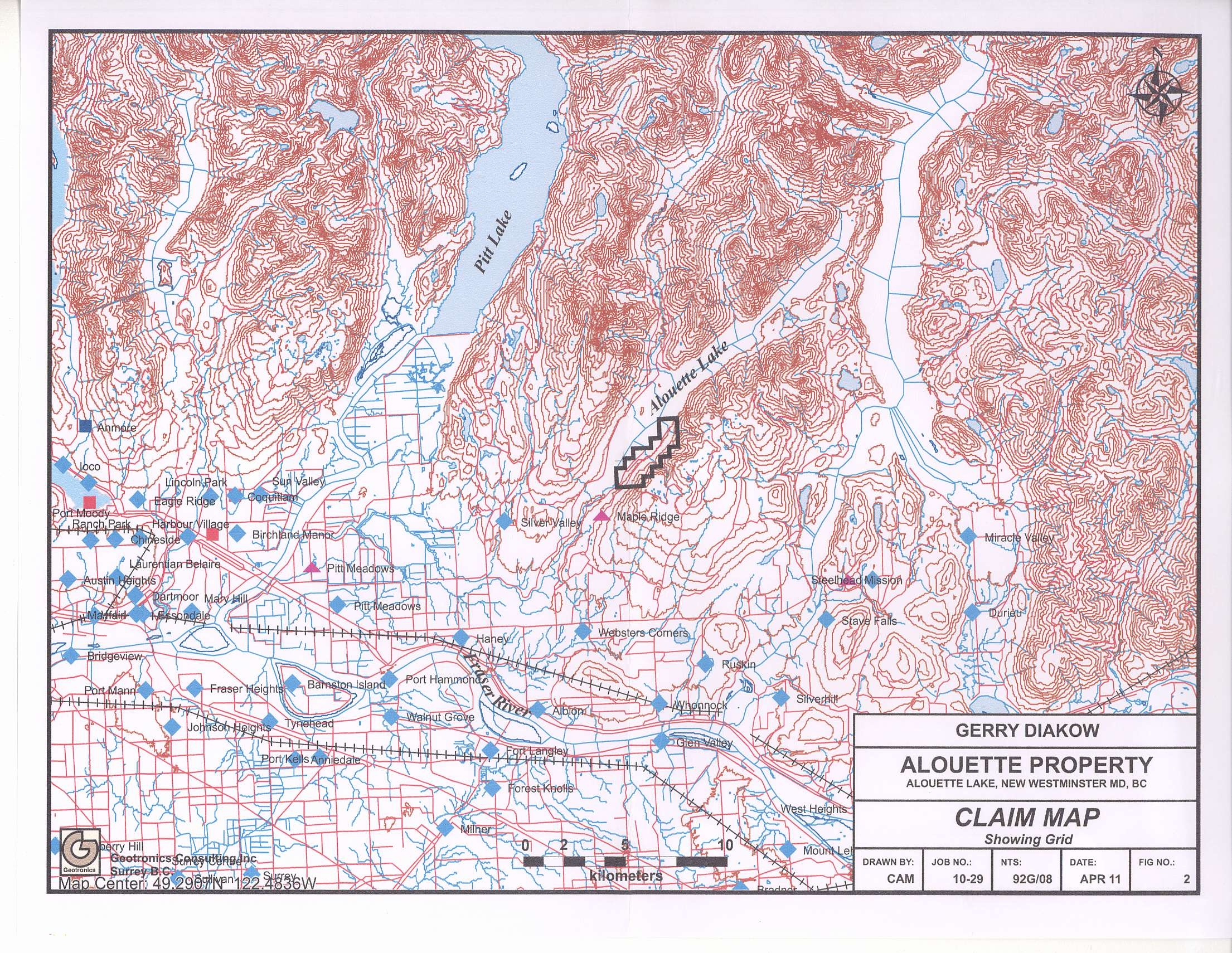
1 TECHNICAL REPORT GEOLOGICAL OUTCROP SURVEY OF THE BLUESTONE CLAIMS ALOUETTE LAKE, VANCOUVER MINING DIVISION, BRITISH COLUMBIA LOCATED: 47.6 km east of the city of Vancouver 49 29'North Latitude, and ' West Longitude NTS: 92G/08 WRITTEN BY: Gerry Diakow th Street Delta, BC V4M 3H6 DATED: FEB. 10, 2014 GEOLOGICAL SURVEY BRANCH ASSESSMENT REPORT
2 TABLE OF CONTENTS page SUMMARY 3 CONCLUSION 3 RECOMMENDATION 3 PROPERTY AND OWNERSHIP 3 LOCATION AND ACCESS 3 PHYSIOGRAPY AND VEGETATION 4 HISTORY 4 REGIONAL GEOLOGY 4 SURVEY PROCEDURE 4 DISSCUSSION OF SAMPLE LITHOLOGY 4 AFFIDAVIT OF EXPENSES 7 STATEMENT OF QUALIFICATIONS 8 LIST OF ILLUSTRATIONS Figure 1: Location of claims Figure 2: Road Access Figure 3: CLAIM MAP Figure 4: OUTCROP SURVEYSi LOCATION OF SAMPLES map pocket map pocket map pocket map pocket
3 SUMMARY A 2-line grid was emplaced and an outcrop survey was carried out between the grid within the Alouette Property which is located on and to the immediate east of Alouette Lake, about 48 km east of Vancouver and about 21 km east of Coquitlam within the Vancouver Mining Division of B.C. The main purpose of the exploration program was to measure the known gabbro outcrops exposed on the claim area. The purpose of the outcrop survey was to establish a surface area of the exposed gabbro and to distinguish variations in the gabbro I it ho logy across the surface of the outcrop. CONCLUSIONS 1. The gabbro is exposed by glaciations the southern block is slightly lower in elevation and has over twice the surface area of the northern gabbro outcrop. 2. The gabbro varies in lithology from south to north. RECOMMENDATIONS The magnetic survey completed in 2011 appeared to be effective in mapping gabbro intrusives and thus it is recommended to continue the surveying and to trench between the exposed outcrops which could lead to enlarging the gabbro resource. PROPERTY AND OWNERSHIP The property is comprised of 1 tenure that comprise an area of ha and occurs within the Vancouver Mining Division as shown on figures #2 and #3. These tenures occur on BC Mineral Title map sheet M092G.028 &.038. Tenure Number Type Claim Name Good Until Area (ha) Mineral Bluestone 2014/jul/ These claims are owned by Gerry Diakow. The expiry date shown assumes the assessment work as described within this report is excepted for assessment credits. LOCATION AND ACCESS The Alouette Property is located within the south-western section of British Columbia, as shown on figure #1,21 km to the east of the city of Coquitlam and 47.6 km to the east of Vancouver. Part of the tenure overlaps Alouette Lake. This property occurs within NTS map sheet number 92G/08. For the center of the property, the latitude is 49 29' North and the longitude is ' West. The property boundaries occur within UTM co-ordinates and east; and and north. Starting at Maple Ridge, drive east on Dewdney Trunk Road to 256 street. Exit north on 256
4 Street and continue for 4.7 kilometers to the end of pavement. Continue another 2.0 kilometers on this maintained dirt road to the Hydro gate. The MR claim grid is located on the immediate right side of the road. This is a public road system and is maintained year round. PHYSIOGRAPHY AND VEGETATION The topography on the east side of the claim boundary is flat and swampy. The elevation difference from the access road to the grid area is at approximately 5 meters. This area consists of second growth timber mainly of cedar and hemlock species. HISTORY OF PREVIOUS WORK There is no previous work known to the writer to have been done on this property. GEOLOGY (a) Regional The majority of the region is underlain by Coast Plutonic Rocks. Lithologic units range from gabbro to granite but diorite, quartz diorite, and granodiorite intrusions of the Jurassic to Cretaceous Coast Plutonic Complex are most abundant. Roof pendants and cappings of pre and post Coast Plutonic Rocks occur throughout the area. They consist of metasediments and volcanics, including the Paleozoic Twin Island Group, the Jurassic Harrsion Lake Formatiin and the Lower Cretaceous Gambier Group. The region has been subjected to faulting and shearing with accompanying fracturing. (b) Property The claim area is generally underlain by the coarse to medium grained quartz diorite with minor phases of diorite and granodiorite. The GSC has determined the granodiorite phase to be younger than the quartz diorite and the quartz diorite younger than the diorite. All these intrusives are members of the Coast Plutonic Group. Personnel communication with Dr. R.E. Beavon suggested that the gabbro intruded into a fault zone and has not been mapped other than by explorers of these claims. SURVEY PROCEDURE Two parallel surveyed lines were established in a north-south direction on either side of the outcrop from these lines the length and width of the outcroppings were measured using a compass, GPS instrument and a chain (figure 4). Seven samples representing lithology variation in the gabbro outcrop were collected. The sample locations are shown on the survey map figure 4. DISCUSSION OF SAMPLE LITHOLOGY Sample 1 Grid Location: UTM Structure: intrusive granite grading into nephaline syenite possible stock or dyke
5 Color: white-pale green Mineral Composition: potassic feldspar, quartz, minor magnetite Grain Size: coarse Fracture Characteristics: hackly, angular blocky, weathered surface thin brown rind Sample 2 Grid Location: UTM Structure: intrusive syenite Color: dark grey porphyritic Mineral Composition: quartz, magnetite, nepheline, minor pyrite Grain Size: coarse Fracture Characteristics: hackly, angular blocky, weathers drusy surface light brown color Sample 3 Grid Location: UTM Structure: intrusive gabbro Color: dark green-black Mineral Composition: quartz, magnetite, nepheline, rare pyrite Grain Size: carse Fracture Characteristics: hackly, angular blocky, weathers drusy surface light brown color Sample 4 Grid Location: UTM Structure: intrusive gabbro Color: greenish blue-black Mineral Composition: quartz, magnetite, nepheline, minor pyrite Grain Size: coarse Fracture Characteristics: hackly, angular blocky, weathers drusy surface light brown color
6 Sample 5 Grid Location: UTM Structure: intrusive gabbro Color: blue-black Mineral Composition: quartz, nepheline, greater than 1% pyrrhotite Grain Size: fine sand Fracture Characteristics: hackly, angular blocky, weathers reddish color Sample 6 Grid Location: UTM Structure: intrusive gabbro Color: blue-black Mineral Composition: quartz, nepheline, 5 % to 10% sulfides mainly pyrrhotite some magnetite Grain Size: fine sand Fracture Characteristics: hackly, angular blocky, weathers reddish color Sample 7 Grid Location: UTM Structure: intrusive gabbro Color: blue-black Mineral Composition: quartz, nepheline, less than 1% sulfides large magnetite cystals Grain Size: pegmatitic Fracture Characteristics: drusy weathered surface, hackly fracture
7 AFFIDAVIT OF EXPENSES Grid emplacement as well as outcrop surveying was carried out on a grid within the Alouette Property, which is located 21 km east of the city of Coquitlam, B.C. and on the southeast shore of Alouette Lake. This work was done on July 11th to July 12th, 2013, and to the value of the following: FIELD (Grid Emplacement and outcrop Surveying): FIELD (July): Mob/demob, Delta to claims access restricted by inability to attain key to hydro gate first trip undertaken on June 15,2013 key not made available until July 10 th, 2013 time and fuel $ Hector Diakow geological technician 1 July 12 $ Gerry Diakow chief surveyor 2 July 11th to July 12th $ Vehicle and equipment 2 $ Report and maps $ TOTAL $2, Respectively submitted Stephen G. Diakow
8 STATEMENT OF QUALIFICATION STEPHEN G. DIAKOW I attended Vancouver City College and the University of British Columbia completing courses in chemistry, physics. 1. Studied Civil and Structural Engineering at British Columbia Institute of Technology. 2. I have worked in Mineral Exploration for the past 40 years. Including the major companies Union Carbide Mining Exploration, Canadian Superior Mining Exploration and Anaconda Mining Exploration. 3. I have received 3 British Columbia prospector assistance grants, the first from Dr. Grove in 1975 and last in Member of the Society Of Economic Geologists 8

9
10

11
12 0 537Z93 US CO Bluesione Claims /(i^afi+tc Lake, M<vj>le Ri(Ag e O to Scale meters I: (00 _ 0 "1 (9-. P. Feb \0/m fit, *
Earth Materials: Intro to rocks & Igneous rocks. The three major categories of rocks Fig 3.1 Understanding Earth
 Earth Materials: 1 The three major categories of rocks Fig 3.1 Understanding Earth 2 Intro to rocks & Igneous rocks Three main categories of rocks: Igneous Sedimentary Metamorphic The most common minerals
ES 104: Laboratory # 7 IGNEOUS ROCKS
 ES 104: Laboratory # 7 IGNEOUS ROCKS Introduction Igneous rocks form from the cooling and crystallization of molten rock material. This can occur below the surface of the earth forming intrusive rocks
BOWEN'S REACTION SERIES
 BOWEN'S REACTION SERIES Purpose John J. Thomas Frequently, people cannot visualize the mineral associations that form the sequences of igneous rocks that you find in the earth's crust and what happens
FORWARD LOOKING STATEMENTS
 MPH Ventures Corp. (MPS: TSX.V) Advancing Gold and Molybdenum Projects in Canada June 2013 1 FORWARD LOOKING STATEMENTS This presentation may contain forward-looking statements including but not limited
INTERPRETATION ADDENDUM CANADIAN MINING COMPANY INC. SUITE 2300-1066 WEST HASTINGS STREET VANCOUVER, BC V6E 3X2 3D INDUCED POLARIZATION
 INTERPRETATION ADDENDUM FOR CANADIAN MINING COMPANY INC. SUITE 2300-1066 WEST HASTINGS STREET VANCOUVER, BC V6E 3X2 3D INDUCED POLARIZATION ON THE SAN BERNARDO PROJECT EL GOCHICO GRID Approximate Location:
** Rocks are aggregates of one or more minerals ** 3. Hardness: A measure of resistance to scratching. On the Mohs Scale, it ranges from 1 to 10.
 Lab 2: Mineral Lab notes. Minerals are inorganic, solid, naturally occurring substances that have a characteristic chemical compositions, distinctive physical properties, and crystalline structures. Chemical
Rock Identification Lab
 Rock Identification Lab Name Mineral Hardness Objective: You will determine the relative hardness of common objects relative to the known hardness of index minerals. We will use fingernail, copper, glass,
2010-2011 PROSPECTING REPORT. Broken Hill Property. EVENT # 4844124 TENURE # 600988 Tenure Name: Broken Hill. New Westminster Mining Division Map 092H
 2010-2011 PROSPECTING REPORT Broken Hill Property EVENT # 4844124 TENURE # 600988 Tenure Name: Broken Hill New Westminster Mining Division Map 092H Central Coordinate Reference 121 24 06.2 W Longitude
Rocks & Minerals. 10. Which rock type is most likely to be monomineralic? 1) rock salt 3) basalt 2) rhyolite 4) conglomerate
 rock salt 3) basalt 2) rhyolite 4) conglomerate") 1. Of the Earth's more than 2,000 identified minerals, only a small number are commonly found in rocks. This fact indicates that most 1) minerals weather before they can be identified 2) minerals have
1. Of the Earth's more than 2,000 identified minerals, only a small number are commonly found in rocks. This fact indicates that most 1) minerals weather before they can be identified 2) minerals have
The Geology of the Marginal Way, Ogunquit, Maine
 Geologic Site of the Month February, 2002 The Geology of the Marginal Way, Ogunquit, Maine 43 14 23.88 N, 70 35 18.36 W Text by Arthur M. Hussey II, Bowdoin College and Robert G. Marvinney,, Department
Presents the. Rock Test Study Resource
 Presents the Rock Test Study Resource Created by Simone Markus Published by EngLinks 1 Preface This is a free resource provided by EngLinks for students in APSC 151. This presentation is a supplementary
PICTOU PROPERTY : ATLIN GOLD CAMP
 PICTOU PROPERTY : ATLIN GOLD CAMP EXECUTIVE SUMMARY The Pictou Property in the Atlin Gold Camp ( AGC ) is an example of a Motherlode- Bonanza, lode gold, quartz vein exploration target in the northern
Name: Class: Date: Multiple Choice Identify the letter of the choice that best completes the statement or answers the question.
 Class: Date: Minerals Study Guide Modified True/False Indicate whether the sentence or statement is true or false. If false, change the identified word or phrase to make the sentence or statement true.
For personal use only
 ANNOUNCEMENT TO THE AUSTRALIAN SECURITIES EXCHANGE: 18 March 2013 Update on Bunawan and Bahayan Permit Approvals. The Directors of Sierra Mining Limited ( Sierra ) are pleased to update shareholders on
P1: Rock identification (I)
") P1: Rock identification (I) Examine the rocks specimens provided with the aid of these notes. All the rocks come from Ireland, as detailed on the attached map. Answer the short question on each specimen
P1: Rock identification (I) Examine the rocks specimens provided with the aid of these notes. All the rocks come from Ireland, as detailed on the attached map. Answer the short question on each specimen
How Did These Ocean Features and Continental Margins Form?
 298 10.14 INVESTIGATION How Did These Ocean Features and Continental Margins Form? The terrain below contains various features on the seafloor, as well as parts of three continents. Some general observations
ROME RESOURCES LTD. 205 16055 Fraser Highway Surrey, B.C. V4N 0G2
 Page 1 of 6 ROME RESOURCES LTD. 205 16055 Fraser Highway Surrey, B.C. V4N 0G2 FAX# (604) 507-2187 TSX-VEN Symbol RMR; Frankfurt: 33R WEB: www.romeresources.com CH Valoren No 699 171 Email: info@romeresources.com
Magnetic survey at Nesodden survey and interpretation report
 Client Date Nordic Mining 25/10 2012 Project GeoVista ID Magnetic survey, Nesodden GVR12035 Author Client ID Hans Thunehed Magnetic survey at Nesodden survey and interpretation report October 2012 GeoVista
Using Google Earth to Explore Plate Tectonics
 Using Google Earth to Explore Plate Tectonics Laurel Goodell, Department of Geosciences, Princeton University, Princeton, NJ 08544 laurel@princeton.edu Inspired by, and borrows from, the GIS-based Exploring
2008-2009 PROSPECTING REPORT. Ghost Lake Serpentine Property. EVENT # 4282919 TENURE # 558949 Tenure Name: Ghost Lake Serpentine
 2008-2009 PROSPECTING REPORT Ghost Lake Serpentine Property EVENT # 4282919 TENURE # 558949 Tenure Name: Ghost Lake Serpentine New Westminster Mining Division Map 092H Central Coordinate Reference 121
How To Map A Lake In The North Of The Holland (Fiji)
") 1. Hydrogelogical mapping Jiri Sima Aim of HG map Groundwater and rocks qualitative permeability and quantitative potential of rock units aquifers / aquitards / aquiclides Water points (spatial distribution
1. Hydrogelogical mapping Jiri Sima Aim of HG map Groundwater and rocks qualitative permeability and quantitative potential of rock units aquifers / aquitards / aquiclides Water points (spatial distribution
REPORT OF WORK GUIDELINES
 REPORT OF WORK GUIDELINES The following guidelines apply to a report of work submitted under section 56(1) of the Mining Act (http://laws.gnb.ca/en/showdoc/cs/m-14.1). 1 (1) A report of work shall be submitted
Earth Coordinates & Grid Coordinate Systems
 Earth Coordinates & Grid Coordinate Systems How do we model the earth? Datums Datums mathematically describe the surface of the Earth. Accounts for mean sea level, topography, and gravity models. Projections
I+/' RD. 2 f.*rj GEOLOGICAL AND GEOCHEMICAL REPORT. on the SECOND CLAIM CROUP CLINTON MINING DIVISION, BRITISH COLUMBIA
 RD. I GEOLOGICAL AND GEOCHEMICAL REPORT on the SECOND CLAIM CROUP CLINTON MINING DIVISION, BRITISH COLUMBIA I+/' Latitude 51' k3' North Longitude 122' 03' West 2 f.*rj N.T.S. 920/1E by JOHN A, McCLINTOCK,
RAINBOW AURORA INDIAN PROPERTIES Goodpaster Mining District, Alaska
 RAINBOW AURORA INDIAN PROPERTIES Goodpaster Mining District, Alaska Prepared by: Carl Schaefer CPG# 10834 Northern Associates, Inc. February, 2006 Tonogold Resources, Inc. 5771 La Jolla Boulevard La Jolla,
ACQUIRING MINERAL RIGHTS IN THE NORTHWEST TERRITORIES
 ACQUIRING MINERAL RIGHTS IN THE NORTHWEST TERRITORIES Introduction Establishing and maintaining strong working relationships between the mineral industry and Northwest Territories (NWT) residents and community
1. Base your answer to the following question on on the photographs and news article below. Old Man s Loss Felt in New Hampshire
 UNIT 3 EXAM ROCKS AND MINERALS NAME: BLOCK: DATE: 1. Base your answer to the following question on on the photographs and news article below. Old Man s Loss Felt in New Hampshire FRANCONIA, N.H. Crowds
Plotting Earthquake Epicenters an activity for seismic discovery
 Plotting Earthquake Epicenters an activity for seismic discovery Tammy K Bravo Anne M Ortiz Plotting Activity adapted from: Larry Braile and Sheryl Braile Department of Earth and Atmospheric Sciences Purdue
Miocene Metals and Carube Resources Announce Start of Drilling on Bellas Gate Copper- Gold Joint Venture Project in Jamaica
 Miocene Metals and Carube Resources Announce Start of Drilling on Bellas Gate Copper- Gold Joint Venture Project in Jamaica Toronto, Ontario February 27, 2014 Miocene Metals Limited ( Miocene ) (TSXV:MII)
For personal use only
 January, 202 Silver Swan Group Limited December 20 Quarterly Activities Report HIGHLIGHTS STAKEWELL Gold Project: Drilling intersected high and low grade gold mineralisation at Kohinoor, including surface
PMR EXPLORATION, LLC CHERRY CLAIMS PROJECT MONARCH MINE GOLDEN IDOL MINE (HILLSIDE) CHERRY KING MINE GOLD EAGLE MINE
 CHERRY KING MINE GOLD EAGLE MINE") PMR EXPLORATION, LLC CHERRY CLAIMS PROJECT MONARCH MINE GOLDEN IDOL MINE (HILLSIDE) CHERRY KING MINE GOLD EAGLE MINE PMR EXPLORATION, LLC - ALL RIGHTS RESERVED - 2011 PMR EXPLORATION, LLC - property information
PMR EXPLORATION, LLC CHERRY CLAIMS PROJECT MONARCH MINE GOLDEN IDOL MINE (HILLSIDE) CHERRY KING MINE GOLD EAGLE MINE PMR EXPLORATION, LLC - ALL RIGHTS RESERVED - 2011 PMR EXPLORATION, LLC - property information
Plate Tectonics. Introduction. Boundaries between crustal plates
 Plate Tectonics KEY WORDS: continental drift, seafloor spreading, plate tectonics, mid ocean ridge (MOR) system, spreading center, rise, divergent plate boundary, subduction zone, convergent plate boundary,
Chapter Overview. Bathymetry. Measuring Bathymetry. Echo Sounding Record. Measuring Bathymetry. CHAPTER 3 Marine Provinces
 Chapter Overview CHAPTER 3 Marine Provinces The study of bathymetry charts ocean depths and ocean floor topography. Echo sounding and satellites are efficient bathymetric tools. Most ocean floor features
Porphyry Copper Potential Confirmed By Field Reconnaissance in Peru
 4 December 2013 Porphyry Copper Potential Confirmed By Field Reconnaissance in Peru Highlights Experienced Consultant Geologist with South American Copper-Gold experience engaged Field reconnaissance by
Earth Materials: Minerals. Mineral Properties. Mineral Properties. Some optical properties. Three general categories:
 1 2 Earth Materials: Minerals What is a mineral? Properties/characteristics of different types of minerals Mineral structures and bonding Major categories of minerals Importance and uses of minerals What
1 Exploring Earth s Interior
 1 Exploring Earth s Interior Crust Mantle Outer Core Crust-to-Mantle Inner Core Cross Section From Surface to Center SCIENCE EXPLORER Focus on Earth Science Prentice-Hall, Inc. 2 Evidence for Continental
Three Main Types of Rocks Igneous Rocks. Sedimentary Rocks Metamorphic Rocks. Made by Liesl at The Homeschool Den
 Three Main Types of Rocks Igneous Rocks Sedimentary Rocks Metamorphic Rocks Igneous Rocks Above and below: Basalt Above: Gabbro Above: Pumice Above: Basalt, Giant Causeway in Ireland Above: Obsidian Above:
3D Visualization of Seismic Activity Associated with the Nazca and South American Plate Subduction Zone (Along Southwestern Chile) Using RockWorks
 Using RockWorks") 3D Visualization of Seismic Activity Associated with the Nazca and South American Plate Subduction Zone (Along Southwestern Chile) Using RockWorks Table of Contents Figure 1: Top of Nazca plate relative
3D Visualization of Seismic Activity Associated with the Nazca and South American Plate Subduction Zone (Along Southwestern Chile) Using RockWorks Table of Contents Figure 1: Top of Nazca plate relative
Name: Rocks & Minerals 1 Mark Place, www.learnearthscience.com
 Name: Rocks & Minerals 1 KEY CONCEPT #1: What is a mineral? It is a, substance which has a What would be the opposite of this? KEY CONCEPT #2: What causes minerals to have different physical properties?
Drillhole Log Units Meters
 iresources Ltd Drillhole Log Units Meters Q-Gold (Ontario) Ltd Province/State Co-ordinate System Grid/Property Hole Type Length Date Started Ontario UTM NAD83 Canada Zone 15 MG Grid Exploration hole 162.00
Chapter 2. Plate Tectonics. Plate Tectonics: Learning Goals
 Plate Tectonics Chapter 2 Interactions at depend on the direction of relative plate motion and the type of crust. Which kind of plate boundary is associated with Earthquake activity? A. Divergent Boundary
Drillhole Log Units Meters
 iresources Ltd Drillhole Log Units Meters Q-Gold (Ontario) Ltd Province/State Co-ordinate System Grid/Property Hole Type Length Date Started Ontario UTM NAD83 Canada Zone 15 MG Grid Exploration hole 171.00
For personal use only
 ASX Release 5 August 205 Colluli potassium rich brines to supplement process water ASX Code: Issued Capital Share Price Market Capitalisation Shares on issue Company options Cash Board of Directors Mr
SITE RECOMMENDED FOR INCLUSION IN THE LIST OF HISTORICAL SITES AND MONUMENTS IN ANTARCTICA
 SITE RECOMMENDED FOR INCLUSION IN THE LIST OF HISTORICAL SITES AND MONUMENTS IN ANTARCTICA Introduction This paper was introduced during the XXVI ATCM at Madrid. As per the Report of the Committee for
Chapter 5. Rules and Policies
 Chapter 5 Rules and Policies 5.1.1 NI 43-101 Standards of Disclosure for Mineral Projects, Form 43-101F1 Technical Report and Related Consequential Amendments NATIONAL INSTRUMENT 43-101 STANDARDS OF DISCLOSURE
Step 2: Learn where the nearest divergent boundaries are located.
 What happens when plates diverge? Plates spread apart, or diverge, from each other at divergent boundaries. At these boundaries new ocean crust is added to the Earth s surface and ocean basins are created.
NEWS RELEASE NOT FOR DISSEMINATION IN THE UNITED STATES OR FOR DISTRIBUTION TO U.S. WIRE SERVICES
 Suite 250, 1075 West Georgia Street Vancouver, BC, Canada V6E 3C9 Tel: 1.778.373.0102 Fax: 1.604.434.1487 NEWS RELEASE NOT FOR DISSEMINATION IN THE UNITED STATES OR FOR DISTRIBUTION TO U.S. WIRE SERVICES
Earth Science & Environmental Science SOL
 Earth Science & Environmental Science SOL THE SOL FOR GRADE 6 The Virginia Science SOL for Grades K 6 are organized according to a set of strands, with the SOL in each strand developed progressively through
Chalice advances gold exploration initiatives in Australia and Canada
 ABN 47 116 648 956 ASX Announcement 4 July 2016 Chalice advances gold exploration initiatives in Australia and Canada Low-cost exploration planned to evaluate opportunities in two world-class gold provinces
Igneous Rocks. Geology 200 Geology for Environmental Scientists
 Igneous Rocks Geology 200 Geology for Environmental Scientists Magma Compositions Ultramafic - composition of mantle Mafic - composition of basalt, e.g. oceanic crust. 900-1200 o C, 50% SiO 2 Intermediate
EXPLORATION 1.0 2.0 3.0. 4.0 5.0 6.0 TONY HOUSTON Head of Exploration 7.0 8.0 9.0
 EXPLORATION 1.0 2.0 3.0 4.0 5.0 6.0 TONY HOUSTON Head of Exploration 7.0 8.0 9.0 OZ MINERALS NOVEMBER 2009 PAGE 54 STRATEGY SUPERIOR TOTAL SHAREHOLDER RETURNS ZERO HARM FOCUS ON COPPER MAXIMISE POTENTIAL
Assignment #3: Plate Tectonics
 Assignment #3: Plate Tectonics Overview: In this assignment we will examine the ideas of continental drift and of sea-floor spreading that lead to the Theory of Plate Tectonics. This assignment is in two
How can you tell rocks apart?
 How can you tell rocks apart? Grade Range: 4-7 G.L.E Focus: 1.1.5 Time Budget: 1 1.5 hours WASL Vocabulary: Overview: Different rocks have different characteristics because of their minerals, the ways
Focus On You Photography TRT from Brockway Summit to Watson Lake
 Tahoe Rim Trail (TRT) From Hwy 267 (Brockway Summit) west to Watson Lake (Strong Intermediate Advanced) This trail is very demanding. It is almost 2100 ft. of climbing. The trail is up and down, up and
EARTH SCIENCE 110 INTRODUCTION to GEOLOGY MINERALS & ROCKS LABORATORY
 EARTH SCIENCE 110 INTRODUCTION to GEOLOGY DR. WOLTEMADE NAME: SECTION: MINERALS & ROCKS LABORATORY INTRODUCTION The identification of minerals and rocks is an integral part of understanding our physical
Instructor: Ms. Terry J. Boroughs Geology 305 INTRODUCTION TO ROCKS AND THE ROCK CYCLE
 DATE DUE: Name: Instructor: Ms. Terry J. Boroughs Geology 305 INTRODUCTION TO ROCKS AND THE ROCK CYCLE Instructions: Read each question carefully before selecting the BEST answer Provide specific and detailed
3. Practice describing and classifying rocks as sedimentary, metamorphic or igneous.
 Science Unit: Lesson 3: Renewable & Non-renewable Resources Mining in BC School Year: 2009/20010 Developed for: Developed by: Grade level: Duration of lesson: Notes: Dr. R. E. McKechnie Elementary School,
Instructor: Ms. Terry J. Boroughs Geology 305 INTRODUCTION TO ROCKS AND THE ROCK CYCLE
 DATE DUE: Name: Instructor: Ms. Terry J. Boroughs Geology 305 INTRODUCTION TO ROCKS AND THE ROCK CYCLE Instructions: Read each question carefully before selecting the BEST answer Provide specific and detailed
Continental Drift. Alfred Wegener (1880-1930) Proposed that all of the continents were once part of a large supercontinent - Pangaea Based on:
 Proposed that all of the continents were once part of a large supercontinent - Pangaea Based on:") Plate Tectonics and Continental Drift Continental Drift Alfred Wegener (1880-1930) Proposed that all of the continents were once part of a large supercontinent - Pangaea Based on: Similarities in shorelines
Plate Tectonics and Continental Drift Continental Drift Alfred Wegener (1880-1930) Proposed that all of the continents were once part of a large supercontinent - Pangaea Based on: Similarities in shorelines
FIRST GRADE ROCKS 2 WEEKS LESSON PLANS AND ACTIVITIES
 FIRST GRADE ROCKS 2 WEEKS LESSON PLANS AND ACTIVITIES ROCK CYCLE OVERVIEW OF FIRST GRADE CHEMISTRY WEEK 1. PRE: Comparing solids, gases, liquids, and plasma. LAB: Exploring how states of matter can change.
Coquihalla Gold Belt Project Reconnaissance and Sampling
 Coquihalla Gold Belt Project Reconnaissance and Sampling Claim ID Number: 600070 New Westminster Mining Division NTS 092H06 Claim Location: UTM NAD 83: Zone 10, 629500 East 5477000 North Registered Owner:
Investigation 6: What happens when plates collide?
 Tectonics Investigation 6: Teacher Guide Investigation 6: What happens when plates collide? In this activity, students will use the distribution of earthquakes and volcanoes in a Web GIS to learn about
Equitas Resources Corp. Intercepts Disseminated Sulphides over 69 Meters at the Garland Property
 BUILDING VALUE THROUGH DISCOVERY www.equitasresources.com Equitas Resources Corp. Intercepts Disseminated Sulphides over 69 Meters at the Garland Property December 16, 2015 - Equitas Resources Corp. (TSXv:
2013 EXPLORATION REPORT Sowaqua Property Group. Report Date - November 18, 2013
 2013 EXPLORATION REPORT Sowaqua Property Group Report Date - November 18, 2013 EVENT # 5477447 Four Contiguous Tenures: 578998 - Sowaqua 3 579003 - Sowaqua 1 579004 - Sowaqua 1 579005 - Sowaqua 1 New Westminster
New Lithium Project includes largest tin tantalum mine in NT HIGHLIGHTS. Core has extended its lithium focus in the prospective Bynoe pegmatite field
 ASX ANNOUNCEMENT ASX : CXO 8 th February 2016 New Lithium Project includes largest tin tantalum mine in NT HIGHLIGHTS Core has extended its lithium focus in the prospective Bynoe pegmatite field NT into
Rocks and Plate Tectonics
 Name: Class: _ Date: _ Rocks and Plate Tectonics Multiple Choice Identify the choice that best completes the statement or answers the question. 1. What is a naturally occurring, solid mass of mineral or
1. The diagram below shows a cross section of sedimentary rock layers.
 1. The diagram below shows a cross section of sedimentary rock layers. Which statement about the deposition of the sediments best explains why these layers have the curved shape shown? 1) Sediments were
Rocks & Minerals 1 Mark Place, www.learnearthscience.com
 Name: KEY Rocks & Minerals 1 KEY CONCEPT #1: What is a mineral? It is a naturally occurring, inorganic substance which has a definite chemical composition What would be the opposite of this? man-made,
Regents Questions: Plate Tectonics
 Earth Science Regents Questions: Plate Tectonics Name: Date: Period: August 2013 Due Date: 17 Compared to the oceanic crust, the continental crust is (1) less dense and more basaltic (3) more dense and
Leapfrog : new software for faster and better 3D geological modelling
 Leapfrog : new software for faster and better 3D geological modelling Paul Hodkiewicz, Principal Consultant (Geology), SRK Consulting, 10 Richardson Street, West Perth WA 6005, Australia, phodkiewicz@srk.com.au
Plate Tectonics: Ridges, Transform Faults and Subduction Zones
 Plate Tectonics: Ridges, Transform Faults and Subduction Zones Goals of this exercise: 1. review the major physiographic features of the ocean basins 2. investigate the creation of oceanic crust at mid-ocean
TSX-V: GEX. An International Mineral Exploration Company
 An International Mineral Exploration Company Cautionary Note Regarding Forward Looking Statements This presentation includes certain forward-looking statements within the meaning of Canadian securities
7) A clastic sedimentary rock composed of rounded to subrounded gravel is called a A) coal. B) shale. C) breccia.
 A clastic sedimentary rock composed of rounded to subrounded gravel is called a A) coal. B) shale. C) breccia.") Please read chapters 10 and 5 CHAPTER 5 Sedimentary Rocks 1) Sedimentary rocks A) form by compaction and cementation of loose sediment. B) are widespread on the continents and ocean floor. C) are common
Please read chapters 10 and 5 CHAPTER 5 Sedimentary Rocks 1) Sedimentary rocks A) form by compaction and cementation of loose sediment. B) are widespread on the continents and ocean floor. C) are common
SGL 101: MATERIALS OF THE EARTH Lecture 5 C.M. NYAMAI SECTION 3 LECTURE 5. 5.0 NATURE AND CLASSIFICATION OF IGNEOUS ROCKS
 SECTION 3 LECTURE 5. 5.0 NATURE AND CLASSIFICATION OF IGNEOUS ROCKS 5.1 INTRODUCTION Welcome to lecture 5. You have now successfully completed section 1 and 2 of this unit. You can now state the basic
Bellhaven Expands the La Garrucha Discovery at the La Mina Project, Colombia
 Bellhaven Expands the La Garrucha Discovery at the La Mina Project, Colombia Denver, Colorado February 28, 2013. Bellhaven Copper & Gold Inc. (TSX-Venture: BHV) ( Bellhaven or the Company ) is pleased
PROSPECTING SURVEY REPORT ON THE KLASK-INO #1 CLAIM NANALMO MJNXNG DXYXSION. NTS: 9245Elk5W Latitude: 5(P 18.9' Longitude: 127" 4-4.
 .........".,....- - PROSPECTING SURVEY REPORT ON THE KLASK-INO #1 CLAIM NANALMO MJNXNG DXYXSION.-e -.s z NTS: 9245Elk5W Latitude: 5(P 18.9' Longitude: 127" 4-4.3' LOGNO: ob27 Ri). I ACT I OM: -- _1 By
REGULATIONS FOR THE POSTGRADUATE DIPLOMA IN EARTH SCIENCES (PGDES)
") REGULATIONS FOR THE POSTGRADUATE DIPLOMA IN EARTH SCIENCES (PGDES) (See also General Regulations) The Postgraduate Diploma in Earth Sciences is a postgraduate diploma awarded for the satisfactory completion
REGULATIONS FOR THE POSTGRADUATE DIPLOMA IN EARTH SCIENCES (PGDES) (See also General Regulations) The Postgraduate Diploma in Earth Sciences is a postgraduate diploma awarded for the satisfactory completion
Magnitude 7.2 GUERRERO, MEXICO
 A powerful magnitude-7.2 earthquake shook central and southern Mexico on Friday. The earthquake occurred at a depth of 24 km (15 miles). Its epicenter was in the western state of Guerrero, near the seaside
89.215 - FORENSIC GEOLOGY GEOLOGIC TIME AND GEOLOGIC MAPS
 NAME 89.215 - FORENSIC GEOLOGY GEOLOGIC TIME AND GEOLOGIC MAPS I. Introduction There are two types of geologic time, relative and absolute. In the case of relative time geologic events are arranged in
DYNAMIC CRUST: Unit 4 Exam Plate Tectonics and Earthquakes
 DYNAMIC CRUST: Unit 4 Exam Plate Tectonics and Earthquakes NAME: BLOCK: DATE: 1. Base your answer to the following question on The block diagram below shows the boundary between two tectonic plates. Which
GEOLOGICAL REINTERPETATION LEADS TO MAJOR DRILL PROGRAM AT JUPITER
 GEOLOGICAL REINTERPETATION LEADS TO MAJOR DRILL PROGRAM AT JUPITER Dacian Gold Ltd ( Dacian or the Company ) (ASX:DCN) is pleased to announce that it has completed a major geological review and reinterpretation
San Gold Launches Timmins Exploration Subsidiary
 Bissett, MB October 29, 2009 San Gold Launches Timmins Exploration Subsidiary SGR: TSX-V www.sangoldcorp.com Mr. Dale Ginn, President of San Gold Corporation (the Corporation ), a company listed on the
RIDDARHYTTAN RESOURCES PRESS RELEASE August 11, 2003
 1 RIDDARHYTTAN RESOURCES PRESS RELEASE August 11, 2003 New drill holes in the Suurikuusikko area, Finland, have further intersected high gold grades over considerable widths, increasing the depth extent
Plate Tectonics Chapter 2
 Plate Tectonics Chapter 2 Does not include complete lecture notes. Continental drift: An idea before its time Alfred Wegener First proposed his continental drift hypothesis in 1915 Published The Origin
FIFTH GRADE PLATE TECTONICS 1 WEEK LESSON PLANS AND ACTIVITIES
 FIFTH GRADE PLATE TECTONICS 1 WEEK LESSON PLANS AND ACTIVITIES PLATE TECTONIC CYCLE OVERVIEW OF FIFTH GRADE VOLCANOES WEEK 1. PRE: Exploring the rocks produced by volcanoes. LAB: Comparing igneous rocks.
Continental Drift, Sea Floor Spreading and Plate Tectonics
 Page 1 of 13 EENS 1110 Tulane University Physical Geology Prof. Stephen A. Nelson Continental Drift, Sea Floor Spreading and Plate Tectonics This page last updated on 26-Aug-2015 Plate Tectonics is a theory
Pacifico set to commence drilling at Borroloola West Project and co-funding secured from NT Government
 CORPORATE DIRECTORY Managing Director Simon Noon Directors Richard Monti (Chairman) Peter Harold (Non-exec.) Andrew Parker (Non-exec.) Company Secretary Joshua Ward Patrick Holywell Registered office Level
www.capcoroofing.ie www.capcoroofing.co.uk
 www.capcoroofing.ie www.capcoroofing.co.uk Head Office Dublin 01 895 1700 Swords Business Park Swords Co.Dublin f: 01 895 1796 Cork 021 432 0877 Curraghconway South Douglas Cork f: 021 432 0883 Waterford
UTM Zones for the US UTM UTM. Uniform strips Scalable coordinates
 UTM UTM Uniform strips Scalable coordinates Globally consistent, most popular projection/coordinate system for regional to global scale geospatial data (i.e. satellite images global scale datasets USGS/EDC)
Plate Tectonics. Earth, 9 th edition Chapter 2
 1 Plate Tectonics Earth, 9 th edition Chapter 2 2 3 4 5 6 7 8 9 10 11 12 13 14 15 16 Plate Tectonics: summary in haiku form Alfred Wegener gave us Continental Drift. Fifty years later... Continental Drift
Introduction to Classification of Rocks Using the Building Stones of the Brooklyn College Campus
 Rocks and Stones EESC 1101 Introduction to Classification of Rocks Using the Building Stones of the Brooklyn College Campus Rocks and stones are not exactly the same thing: a rock is a natural material
SITE. Name: Killerton. Parish: Silverton. Local Authority: East Devon. National Grid Ref: SS 973 007. OS Sheets: 1:50K, 192, 1:10K, SS90 SE
 SITE Name: Killerton Parish: Silverton Local Authority: East Devon National Grid Ref: SS 973 007 OS Sheets: 1:50K, 192, 1:10K, SS90 SE Locality Description: This site lies to the north of Exeter, just
For personal use only
 L4 66 Kings Park Road West Perth WA 6005 P: +61 8 6141 3585 F: +61 8 6141 3599 E: info@drakeresources.com.au ASX Announcement 8 th August 2014 Nordgruva Drilling Final Assays Drake / Panoramic JV Final
New technology and new approach uncovers new opportunities in WA s Fraser Range
 ASX Code: WIN New technology and new approach uncovers new opportunities in WA s Fraser Range Investor Update May 2016 Bronwyn Barnes, Executive Chair Important Information The information contained in
Plate Tectonics: Big Ideas. Plate Tectonics. Plate Tectonics. The unifying concept of the Earth sciences.
 Plate Tectonics: Big Ideas Our understanding of Earth is continuously refined. Earth s systems are dynamic; they continually react to changing influences from geological, hydrological, physical, chemical,
GEOLOGIC MAPS. PURPOSE: To be able to understand, visualize, and analyze geologic maps
 GEOLOGIC MAPS PURPOSE: To be able to understand, visualize, and analyze geologic maps Geologic maps show the distribution of the various igneous, sedimentary, and metamorphic rocks at Earth s surface in
Report on Engineering Geological Investigation: Test pit logs in KwaMhlanga for RDP houses development.
 Report on Engineering Geological Investigation: Test pit logs in KwaMhlanga for RDP houses development. 2012 Department of Geology GTX 713 Date Excavated: 18 April 2012 Machine: Bell 315SG Operator: Lesley
6. The greatest atmospheric pressure occurs in the 1) troposphere 3) mesosphere 2) stratosphere 4) thermosphere
 troposphere 3) mesosphere 2) stratosphere 4) thermosphere") 1. The best evidence of the Earth's nearly spherical shape is obtained through telescopic observations of other planets photographs of the Earth from an orbiting satellite observations of the Sun's altitude
1. The best evidence of the Earth's nearly spherical shape is obtained through telescopic observations of other planets photographs of the Earth from an orbiting satellite observations of the Sun's altitude
Correlation of Joint Roughness Coefficient (JRC) and Peak Friction Angles of Discontinuities of Malaysian Schists
 and Peak Friction Angles of Discontinuities of Malaysian Schists") Correlation of Joint Roughness Coefficient (JRC) and Peak Friction Angles of Discontinuities of Malaysian Schists Abdul Ghani Rafek Geology Programme, Faculty of Science and Technology, National University
Correlation of Joint Roughness Coefficient (JRC) and Peak Friction Angles of Discontinuities of Malaysian Schists Abdul Ghani Rafek Geology Programme, Faculty of Science and Technology, National University
For personal use only
 Investor Presentation August 2012 Disclaimer/Competent Person s Disclaimer: This presentation has been prepared by Buxton Resources ( Buxton ). The information contained in this presentation is a professional