Impacts of Commercial and Residential Development on the Gulf Intracoastal Waterway: A Case Study in Alabama
|
|
|
- Madeleine Powell
- 7 years ago
- Views:
Transcription

1 Impacts of Commercial and Residential Development on the Gulf Intracoastal Waterway: A Case Study in Alabama Dean Goodin, Ph.D. Eric Dohner Linda Brown, USACE
 Landfall at Gulf Shores and Orange Beach Category 3 with 130 mph")
2 Introduction Coastal Alabama was heavily impacted by Hurricane Ivan (2004) Landfall at Gulf Shores and Orange Beach Category 3 with 130 mph winds

3 Before After

4 Before After

5 Highway 182 (Perdido Beach Blvd)
 67 mph sustained winds Storm surge of 10")
6 Introduction Coastal Alabama was also impacted by Hurricane Katrina (2005) 67 mph sustained winds Storm surge of 10 feet
7 Introduction New development trend in northern Gulf Coast is construction along the Gulf Intracoastal Waterway (GIWW) Threat of tropical storms Escalating prices of beachfront property GIWW extends from Brownsville, TX to Apalachee Bay, FL 520 miles open bays or coastal sounds 780 miles man-made canals

8 Gulf Intracoastal Waterway
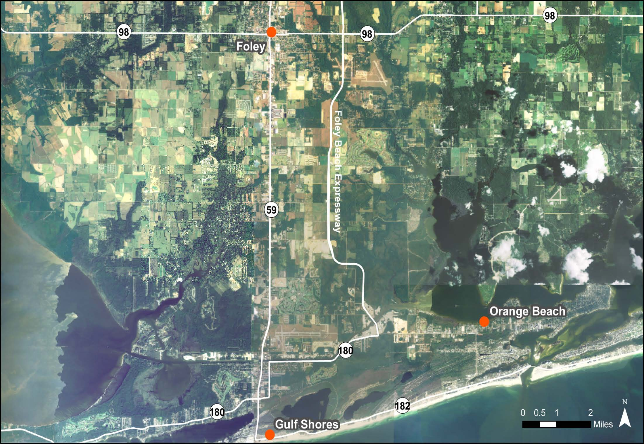
9 Foley Land Cut In coastal Alabama, the Foley Land Cut is poised for development 10-mile stretch of GIWW in Gulf Shores and Orange Beach Located approximately 2 miles inland Authorized channel dimensions 125 feet wide 12 feet deep Maintained by Corps of Engineers for commercial barge traffic operations
10
11

12 Foley Land Cut North Shore East Oyster Bay North Shore West
13 Foley Land Cut Gulf Shores/Orange Beach region developed and marketed as a tourist destination From 1990 to 2000 permanent population increased 50% Gulf Shores 68% Orange Beach 2007 Population ~12,000 Seasonal population expected to increase 30%
14 Foley Land Cut Why FLC? Sheltered from tropical storms Available waterfront property Provides waterway access to Gulf of Mexico via Bon Secour Bay and Wolf Bay Existing development Condominiums/single-family homes Marinas Restaurant Commercial
15

16 Lulu s Homeport Marina Sailboat Bay Marina Reynold s Ready Mix The Wharf
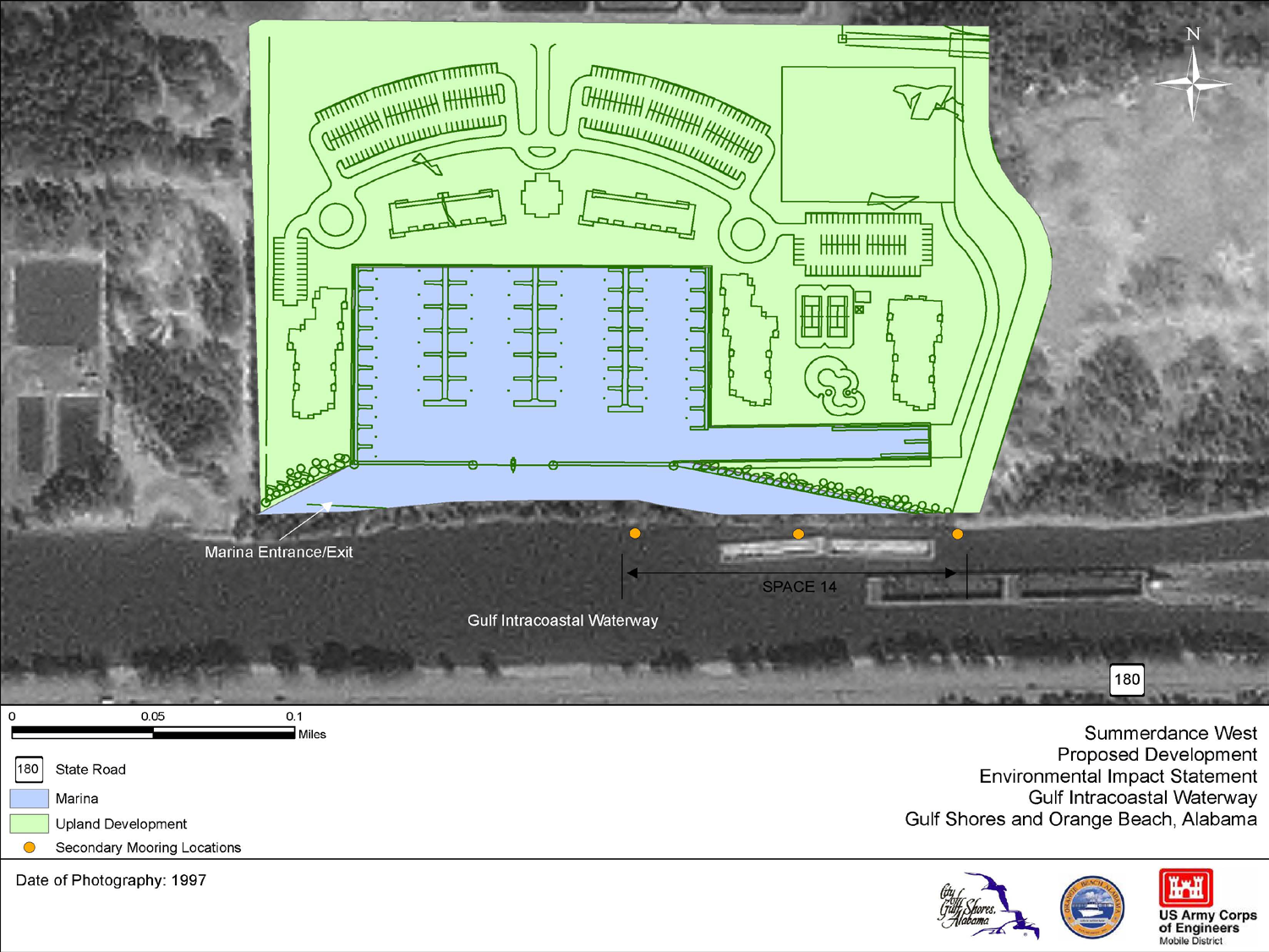
17 Proposed Development 15 proposed developments on FLC 14 located on north shore of FLC 1 located on south shore of Oyster Bay 16,700 condo units 3464 boat slips 1722 wet slips 1742 dry slips Marinas Retail shopping Office space Amenities (pools, greenspace, boardwalks)
18
19 Proposed Development Development Size Boat Slips Condominiums Units Retail/Commercial Greenspace (acres) Wet Dry Permanent Seasonal (square feet) (acres) 47 Canal Place Point West Bayside Harbour Bon Secour Village Eastern Marina Bon Secour Village West ,000 3, , Delfino Resort , Delfino Resort , Harbour Lights Marina ,000 - KFPH Properties ,000 - Lawrenz Eastern Marina , Lawrenz Western Marina Oyster Bay Marina , Summerdance , Walker Creek Waterways East TOTAL ,584,

20
21
22 EIS Environmental Impact Statement (EIS) Evaluate environmental and socioeconomic consequences of development Address potential impacts to FLC and surrounding communities Waterway Capacity Study Hurricane Evacuation Study
23 EIS Direct and indirect impacts Short-term and long-term impacts Cumulative impacts Mitigation of impacts Irreversible and irretrievable commitment of resources Alternatives to proposed actions

24 EIS Cultural Resources Threatened & Endangered Species Wetlands Fish & Wildlife Resources Vegetative Communities Water Quality Soils & Geology Land Use Recreation Resources Utilities Air Quality Noise Light Socioeconomic Resources Traffic & Transportation Hazardous & Toxic Materials
25 Waterway Capacity Study Federally authorized use for commercial traffic Recreational use must not impact present and future commercial operations Safety and navigation concerns Speeding Uneducated boaters Congestion in high use areas (Hwy 59 boat ramp, Lulu s, bridges, etc.)

26 Lulu s Homeport Marina Bon Secour Village Marina Highway 59 Bridge Public Boat Ramp The Wharf Marina
27 Hurricane Evacuation Study Impacts of proposed developments Increased population of permanent and seasonal residents Increased number of vehicles Infrastructure Evacuation routes Vessel evacuation and security plan Shelters
28 Alternatives No Action Alternative Maximum Boat Slip Alternative Approve permits for up to 3093 boat slips through 2025 Minimum Boat Slip Alternative Initially approve 1943 boat slips Option of phasing-in 1150 additional boat slips until reach maximum (3093)
29 Alternatives Alternatives Proposed changes from original proposals Maximum number of additional boat slips a. No Action N/A 0 N/A b. Maximum Boat Slip Alternative Conservative RD approach (bottom number of the 15% confidence range) in the number of boat slips additional slips for implementing accepted mitigation options approved site plans 3,093 boat slips permitted Phase-in for additional boat slips N/A c. Minimum Boat Slip Alternative Conservative RD approach (bottom number of the 15% confidence range) in the number of boat slips potential future phase in approach no additional boat slips, mitigation options not implemented approved site plans 1,943 boat slips initially permitted 1,150 additional boat slips phased in at 25% per evaluation period beginning after Evaluation Period 1. Evaluation Period 1 = 1,943 Evaluation Period 2 = 2,230 Evaluation Period 3 = 2,517 Evaluation Period 4 = 2,804 Evaluation Period 5 = 3,093

30 Impacts Land Use/Land Cover Socioeconomics Recreational Resources Ecological Resources Noise Light Pollution

31 Mitigation Mooring Facilities 4 Primary 10 Secondary 1 Tertiary Safety signage Marine police Boater education Maps for commercial operators

32

33 In Closing EIS provides an objective evaluation of impacts associated with the proposed actions Example for future development along GIWW and Gulf Coast Florida St. Joe Land Company (Apalachicola Bay) Texas Port O Connor (Dolphin Point Community)

34 Questions?
Goal 1 To protect the public health, safety and property from the harmful effects of natural disasters.
 Plan Framework for Coastal Management The purpose of this element is to provide for the protection of residents and property in within the coastal area of the host community, and to limit expenditures,
Gulf Intracoastal Waterway
 TEXAS DEPARTMENT OF TRANSPORTATION Gulf Intracoastal Waterway Photo by TexasGulfCoastOnline.com Gulf Intracoastal Waterway in Texas Figure 1 - Texas GIWW Executive Summary The Texas Department of Transportation
HARBOR INFRASTRUCTURE INVENTORIES Port Austin Harbor, Michigan
 HARBOR INFRASTRUCTURE INVENTORIES Port Austin Harbor, Michigan Harbor Location: Port Austin Harbor is located at the tip of the thumb of Michigan, about 80 miles northeast of Saginaw, MI Authority: Rivers
2. Market Area Background and Demographics Deliverable 1B
 2. Market Area Background and Demographics Deliverable 1B This section evaluates demographic and economic characteristics of the two principal sources of demand in the market area, the resident population
Offshore Alabama Prepared by the University of South Alabama MBA Consulting Group in December 2010
 Offshore Alabama Prepared by the University of South Alabama MBA Consulting Group in December 2010 Executive Summary The Mobile Area Chamber of Commerce s Oil and Gas Task Force (Task Force) was created
RESEARCH. 2010 Massachusetts Recreational Boater Survey. Project Summary
 Coastal and Marine Spatial Planning RESEARCH Project Summary 2010 Massachusetts Recreational Boater Survey The 2010 Massachusetts Recreational Boater Survey gathered spatial and economic data relating
New Orleans Hurricane Storm Damage Risk Reduction System Tour March 23 24, 2012
 New Orleans Hurricane Storm Damage Risk Reduction System Tour March 23 24, 2012 Host: Falcolm E. Hull, Vice President/Technical Expert, ARCADIS, U.S. Inc. Attending: Cherie Coffman, Coastal Projection
Mike Spranger, PhD. Professor, University of Florida spranger@ufl.edu
 Mike Spranger, PhD. Professor, University of Florida spranger@ufl.edu Outline What is Resiliency? Background on Clean and Resilient Marina Initiative Elements of the Clean and Resilient Marina Initiative
Veterans Memorial Bridge (Orange Avenue) PD&E Study
 PD&E Study") Veterans Memorial Bridge (Orange Avenue) PD&E Study From City Island Parkway to South Peninsula Drive FDOT FPID# 242172-128-01 Volusia County Project# P-5351-1 Project Limits End Project City Island Veterans
Veterans Memorial Bridge (Orange Avenue) PD&E Study From City Island Parkway to South Peninsula Drive FDOT FPID# 242172-128-01 Volusia County Project# P-5351-1 Project Limits End Project City Island Veterans
Florida Fish and Wildlife Conservation Commission
 September 10, 2010 Florida Fish and Wildlife Conservation Commission Commissioners Rodney Barreto Chairman Miami Richard A. Corbett Vice Chairman Tampa Kathy Barco Jacksonville Ronald M. Bergeron Fort
FINAL Environmental Impact Statement (EIS) for the
 for the") FINAL Environmental Impact Statement (EIS) for the Mississippi River-Gulf Outlet (MRGO), Louisiana, and Lake Borgne Wetland Creation and Shoreline Protection Project U.S. Army Corps of Engineers New Orleans
FINAL Environmental Impact Statement (EIS) for the Mississippi River-Gulf Outlet (MRGO), Louisiana, and Lake Borgne Wetland Creation and Shoreline Protection Project U.S. Army Corps of Engineers New Orleans
APPENDIX G. California Coastal Commission & Conservancy Accessibility Standards
 APPENDIX G California Coastal Commission & Conservancy Accessibility Standards STANDARDS AND RECOMMENDATIONS FOR ACCESSWAY LOCATION AND DEVELOPMENT These standards provide guidelines for the location,
1. Review your insurance policies and coverage with your local agent.
 Dear Orange Beach Resident: The Community Development Office of The City of Orange Beach, Alabama is providing this information to the residents as part of a public outreach strategy as developed by the
A Coastal Barrier Protecting the Houston/Galveston Region from Hurricane Storm Surge
 A Coastal Barrier Protecting the Houston/Galveston Region from Hurricane Storm Surge 1/20/2011 The Houston/Galveston Region Is home to about 2 Million people and may double by 2050 Galveston Bay provides
Environmental Impact Assessment
 Environmental Impact Assessment E. Beimborn, University of Wisconsin-Milwaukee NEPA: the National Environmental Policy Act Enacted in 1969 Provides a general statement of federal policy towards the environment:
Hurricanes and Storm Surge www.hcfcd.org/tropicalweather
 Hurricanes and Storm Surge www.hcfcd.org High-level winds fl ow outward Strong surface winds spiral inward EYE Calm, sometimes cloudfree, sinking air Air sinks in calm area at the storm s eye THUNDERSTORMS
Facing an Uncertain Future: Increasing Resilience at Marinas and Harbors. Recreational Boating Educational Conference December 11, 2014
 Facing an Uncertain Future: Increasing Resilience at Marinas and Harbors Recreational Boating Educational Conference December 11, 2014 Operators Face Change and Challenges Environmental Conditions Fluctuating
Development Opportunity: Estes Peninsula on Joe Pool Lake, Grand Prairie, Texas
 Request for Proposal Development Opportunity: Estes Peninsula on Joe Pool Lake, Grand Prairie, Texas The City of Grand Prairie is seeking a partner to develop a lakeside resort in the middle of Dallas-Fort
Jacksonville Port Authority: Fire and Rescue Marine Fire Station #40, Jacksonville, Florida
 Draft Tiered Site-Specific Environmental Assessment Jacksonville Port Authority: Fire and Rescue Marine Fire Station #40, Jacksonville, Florida Port Security Grant Program Project # 2008-GB-T8-K019 November
U.S. Army Corps of Engineers
 Walla Walla District U.S. Army Corps of Engineers Hurricane Katrina Response Briefer: Joseph Saxon Today s Briefing U.S. Army Corps of Engineers Mission Events leading up to New Orleans flooding Corp s
Urban Forests in Florida: Storm Damage Assessment Utility for Estimating Hurricane-Caused Tree Debris 1
 FOR268 Urban Forests in Florida: Storm Damage Assessment Utility for Estimating Hurricane-Caused Tree Debris 1 Benjamin Thompson, Francisco Escobedo, Christina Staudhammer, Jerry Bond, and Chris Luley
Preliminary Views on the Draft Early Restoration Programmatic Environmental Impact Statement and Phase III Early Restoration Plan
 Preliminary Views on the Draft Early Restoration Programmatic Environmental Impact Statement and Phase III Early Restoration Plan The Deepwater Horizon Natural Resource Damage Assessment Trustees (Trustees)
Greater New Orleans Hurricane and Storm Damage Risk Reduction System
 Greater New Orleans Hurricane and Storm Damage Risk Reduction System Mike Park Chief Task Force Hope Mississippi Valley Division U.S. Army Corps of Engineers March 15, 2011 US Army Corps of Engineers BUILDING
Briefing Paper on Lower Galveston Bay and Bayou Watersheds Lower Bay I: Armand Bayou to Moses Lake and Adjacent Bay Waters
 Briefing Paper on Lower Galveston Bay and Bayou Watersheds Lower Bay I: Armand Bayou to Moses Lake and Adjacent Bay Waters Jim Lester, PhD. and Lisa Gonzalez Houston Advanced Research Center Galveston
 This is a presentation about the Commission s Rule 68D-24.006, Fort Lauderdale Boating Restricted Areas and Rule 68D-24.008, Broward County Boating Restricted Areas. These rules delineate boating safety
TERMS OF REFERENCE. for an ENVIRONMENTAL IMPACT ASSESSMENT. for a PROPOSED RESORT DEVELOPMENT
 TERMS OF REFERENCE for an ENVIRONMENTAL IMPACT ASSESSMENT for a PROPOSED RESORT DEVELOPMENT at BIG AND LITTLE PELICAN CAY PORTLAND BIGHT, ST. CATHERINE, JAMAICA TABLE OF CONTENTS BACKGROUND 4 1. Executive
Storm tide is the water level rise during a storm due to the combination of storm surge and the astronomical tide.
 INTRODUCTION TO STORM SURGE Introduction to Storm Surge BOLIVAR PENINSULA IN TEXAS AFTER HURRICANE IKE (2008) What is Storm Surge? Inland Extent Storm surge can penetrate well inland from the coastline.
JOINT PUBLIC NOTICE June 28, 2016
 DEPARTMENT OF THE ARMY NEW ORLEANS DISTRICT CORPS OF ENGINEERS REGULATORY FUNCTIONS BRANCH P.O. BOX 60267 NEW ORLEANS, LA 70160 JOINT PUBLIC NOTICE June 28, 2016 STATE OF LOUISIANA DEPARTMENT OF ENVIRONMENTAL
Symbiotic Beachfront Design: Sharing Southeast Florida s Coast with Sea Turtles
 Symbiotic Beachfront Design: Sharing Southeast Florida s Coast with Sea Turtles High Energy Beach Profile Groomed Beach Profile Loggerhead, Caretta caretta Green, Chelonia mydas Leatherback, Dermochelys
Coastal Erosion Risk Mitigation Strategies applied in a Small Island Developing State: The Barbados Model
 Coastal Erosion Risk Mitigation Strategies applied in a Small Island Developing State: The Barbados Model BY Dr. Leo Brewster, Director Coastal Zone Management Unit, Barbados Presented At UNFCCC Expert
COMMERCIAL LANDINGS STATISTICS RED SNAPPER IN THE GULF OF MEXICO. John Poffenberger 1
 SEDAR 7-DW-23 COMMERCIAL LANDINGS STATISTICS RED SNAPPER IN THE GULF OF MEXICO John Poffenberger 1 I. Introduction Data on the quantity and value of seafood products have been collected in varying forms
APPENDIX 2. NJDEP Environmental and Historic Review Application for EDA and DCA/NEP Programs
 APPENDIX 2 NJDEP Environmental and Historic Review Application for EDA and DCA/NEP Programs 1. Agency Name: New Jersey Economic Development Authority 2. Date of Application Submittal to DEP: September
EMERALD GRAND AT DESTIN 10 Harbor Blvd Destin, Florida, 32541 UNITED STATES 1.850.337.8100
 Wyndham Resorts Emerald Grand at Harbor Walk Village - Destin is located at the foot of Marler Bridge, just 4 miles west of the Mid Bay Bridge. The resort boasts sensational views of Destin Harbor, Crab
Storm tide is the water level rise during a storm due to the combination of storm surge and the astronomical tide.
 INTRODUCTION TO STORM SURGE Introduction to Storm Surge National Hurricane Center Storm Surge Unit BOLIVAR PENINSULA IN TEXAS AFTER HURRICANE IKE (2008) What is Storm Surge? Inland Extent Storm surge can
Arkansas River Corridor Vision & Master Plan
 A r k a n s a s R I v e r C o r r I d o r P l a n Arkansas River Corridor Vision & Master Plan July 2005 Indian Nations Council of Governments A r k a n s a s R I v e r C o r r I d o r P l a n Partnership
Environmental Law Primer. Adapted from Vermont Law School s Environmental Law Primer for Journalists
 Environmental Law Primer Adapted from Vermont Law School s Environmental Law Primer for Journalists General Categories Command and Control Liability Disclosure Ecosystem and Place-based Programs Marketable
Southwick Conservation Commission
 1.0 Jurisdiction 1.1 The (Town) annual permitting program is authorized pursuant to 310 CMR 9.07(3) and the DEP letter to the dated January 13, 2010. In the event of any discrepancy between these guidelines
Piers, Wharves & Docks
 Piers, Wharves & Docks Exposures and Concerns By: Christopher L. Pesce May 10, 2011 Piers, Wharves & Docks Statistics Why underwriters love to write docks Estimated industry losses for 2010: $30,000,000
ALABAMA INSURANCE UNDERWRITING ASSOCIATION COMMERCIAL LINES
 ADDITIONAL RULE(S) Wind-Only Policy If desired, a policy covering only the peril of Windstorm or Hail may be issued on an eligible Commercial risk. (Plan of Operation and Rules and Procedures for Submitting
CHAPTER 4 ALTERNATIVES COMPARISON
 CHAPTER 4 ALTERNATIVES COMPARISON 4.1 INTRODUCTION This chapter provides a comparison of the and its alternatives as described in EIS/EIR Section 1.8.3 (s Evaluated in this EIS/EIR) and analyzed in Sections
2012 Project Summary NORTHEAST RECREATIONAL BOATER SURVEY
 2012 Project Summary NORTHEAST RECREATIONAL BOATER SURVEY image courtesy of Urban Harbors Institute of UMass Boston A partnership among industry, government, and nongovernmental organizations conducted
Volume 1-2 Technical Data Report Apalachee Region CHAPTER IV Regional Population and Vulnerability Analysis
 Volume 1-2 Technical Data Report Apalachee Region CHAPTER IV Regional Population and Vulnerability Analysis APPENDIX IV-H Liberty County Critical Facilities and Vulnerability Analysis Statewide Regional
Flood Risk Management
 Flood Risk Management Value of Flood Risk Management Every year floods sweep through communities across the United States taking lives, destroying property, shutting down businesses, harming the environment
Flood Risk Management
 Flood Risk Management Value of Flood Risk Management Value to Individuals and Communities Every year floods sweep through communities across the United States taking lives, destroying property, shutting
Significant investment and improvement of infrastructure and transport networks, delivered at no cost and no risk
 December 2014 FACT SHEET: TRANSPORT AND INFRASTRUCTURE Significant investment and improvement of infrastructure and transport networks, delivered at no cost and no risk The Gold Coast Integrated Resort
Statement of Estimated Regulatory Costs June 2015. Proposed Amendments to Rule 68C-22.016, FAC (Pinellas County manatee protection rule)
") Statement of Estimated Regulatory Costs June 2015 Proposed Amendments to Rule 68C-22.016, FAC (Pinellas County manatee protection rule) Executive Summary In December 2014, the Florida Fish and Wildlife
Statement of Estimated Regulatory Costs June 2015 Proposed Amendments to Rule 68C-22.016, FAC (Pinellas County manatee protection rule) Executive Summary In December 2014, the Florida Fish and Wildlife
002400 - Miami/Ft. Lauderdale
 002400 - Miami/Ft. Lauderdale Description: US 1 ES 185ft S/O SW 104 St F/N - 1 TAB Panel ID: 30740199 City: PINECREST Latitude: 25.674 Media Type: Bulletin State: FL Longitude: -80.32 Display Dimensions:
Florida Sea Grant College Program
 Florida Sea Grant College Program Strategic Plan 2009 2013 Science Serving Florida s Coast Introduction Florida Sea Grant s Strategic Plan for 2009 to 2013 reflects the input of hundreds of Floridians,
Miquon Creek STREAM RESTORATION PROJECT WHO WE ARE
 Miquon Creek STREAM RESTORATION PROJECT WHO WE ARE Introductions Brett Long, PE Project Permitting & Construction Oversight Chris Streb, PE Project Designer & Construction Oversight Assistance WHO WE ARE
Sydney Local Environmental Plan 2012
 New South Wales Environmental Plan 2012 under the Environmental Planning and Assessment Act 1979 I, the Minister for Planning and Infrastructure, pursuant to section 33A of the Environmental Planning and
Segment Two Santa Rosa Sound/Emerald Coast
 Segment Two Santa Rosa Sound/Emerald Coast Emergency contact information: 911 Okaloosa County Sheriff s Office: 850-651-7400 Walton County Sheriff s Office: 850-892-8186 Florida Fish and Wildlife Conservation
APPENDIX B: PUBLIC PARTICIPATION SURVEY RESULTS
 APPENDIX B: PUBLIC PARTICIPATION SURVEY RESULTS APPENDIX B: PUBLIC PARTICIPATION SURVEY RESULTS This section of the Plan includes a general summary of the results and findings of the Public Participation
EXHIBIT D NOTICE. Personal and Commercial Residential Property Insurance. Policies; Extension of Coverage for Damaged Property
 EXHIBIT D NOTICE FINANCIAL SERVICES COMMISSION RULE TITLE: Personal and Commercial Residential Property Insurance RULE NO.: 69OER05-05 Policies; Extension of Coverage for Damaged Property SPECIFIC REASONS
Ecosystem Services in the Greater Houston Region. A case study analysis and recommendations for policy initiatives
 Ecosystem Services in the Greater Houston Region A case study analysis and recommendations for policy initiatives Ecosystem Services Ecosystems provide services through their natural processes that we
U.S. Fish and Wildlife Service will invest $15 million for post-sandy cleanup and marsh restoration on Long Island
 For Immediate Release: Wednesday, November 6, 2013 For further information: Michelle Potter, refuge manager, 631/286-0485 ext. 2112, Michelle_Potter@fws.gov Tom Sturm, public affairs specialist, 413/253-8339,
HURRICANE EVACUATION GUIDE
 booklet-final 6/30/00 9:41 AM Page 1 E M E R G E N C Y P R E P A R E D N E S S HURRICANE EVACUATION GUIDE Vital information you need to know in case of a hurricane evacuation. Information brought to you
Resource Management Accomplishments FY 2014
 Resource Management Accomplishments FY 2014 Sea turtle nest protection - Over 3,700 sea turtle nests were covered with wire mesh screens to protect them from being predated. Data on each sea turtle activity
Travelers Coastal Wind Zone Plan THE TRAVELERS INSTITUTE
 THE TRAVELERS INSTITUTE Travelers Coastal Wind Zone Plan A Comprehensive Plan to Improve Availability and Affordability of Named Storm Wind Insurance for Coastal Homeowners Number of Hurricanes per Year,
FUTURE LAND USE ELEMENT
 GOALS, OBJECTIVES AND POLICIES FUTURE LAND USE ELEMENT GOAL A THE CITY OF FORT WALTON BEACH WILL PLAN FOR AND PROVIDE A HIGH QUALITY OF LIFE TO MEET THE NEEDS OF THE CURRENT AND FUTURE POPULATION, PROVIDING
Existing Land Use Map
 ilsonmiller, nc. does not warrant data provided by other sources for accuracy or property appraisal, survey, or for zoning verification. ilsonmiller, nc. has not verified this data for accuracy nor has
The Everglades & Northern Estuaries; St. Lucie River Estuary, Indian River Lagoon & Caloosahatchee Estuary. Water Flows & Current Issues
 The Everglades & Northern Estuaries; St. Lucie River Estuary, Indian River Lagoon & Caloosahatchee Estuary Water Flows & Current Issues Florida Governor Rick Scott August 20, 2013 Upper Chain of Lakes
A Vision Plan for Panacea VISION PLAN
 VISION PLAN A plan funded in part by the Florida Department of Community Affairs, Florida Coastal Management Program, pursuant to National Oceanic and Atmospheric Administration Award No. NA070ZO112. The
Deepwater Horizon Oil Spill Phase I Early Restoration Plan and Environmental Assessment
 Deepwater Horizon Oil Spill Phase I Early Restoration Plan and Environmental Assessment Prepared by the Deepwater Horizon Natural Resource Trustees from State of Alabama State of Florida State of Louisiana
US 281 AT PREMONT PUBLIC HEARING. US 281 at Premont Public Hearing
 US 281 AT PREMONT PUBLIC HEARING Hearing Purpose The purpose of tonight s Public Hearing is for the public to: Learn about the status of the proposed project Review the purpose and need for the project
United States Army Corps of Engineers, Civil Works
 United States Army Corps of Engineers, Civil Works Fiscal Year 2013 Federal Program Inventory May 2013 Table of Contents Introduction... 2 Program Inventory... 3 1. Navigation... 3 2. Flood Risk Management...
In the Caribbean, August and September are peak months during the hurricane season that lasts from June 1 through November 30.
 Hurricane Fact sheet What is a hurricane? A hurricane is a tropical storm with winds that have reached a constant speed of 74 miles per hour more. Hurricane winds blow in a large spiral around a relative
The Society of American Military Engineers
 The Society of American Military Engineers PRESIDENT Colonel Richard L. Hansen, USA VICE PRESIDENT & CAO Richard C. Entwisle, P.E. FIRST VICE PRESIDENT Anthony F. Goodgion, P.E. TREASURER Jennifer M. Snape,
30 DAY PUBLIC NOTICE MAINTENANCE DREDGING OF THE FEDERAL NAVIGATION PROJECT IN COHASSET HARBOR COHASSET AND SCITUATE, MASSACHUSETTS
 .-ro:'j - I US Army Corps of Engineers r& New England District 696 Virginia Road Concord, MA 01742-2751 Public Notice In Reply Refer to: Mr. Craig Martin nae-pn-nav@usace.army.mil Programs/Project Management
SSPEED Center Phase III: Developing a Houston- Galveston Area Protection System (H-GAPS)
") Center Phase III: Developing a Houston- Galveston Area Protection System (H-GAPS) The Center 6100 Main St., MS317 Houston, Texas 77005 June 2, 2014 DPCAC meeting Center Phase I & II Recap (2009-2014) Phase
Center Phase III: Developing a Houston- Galveston Area Protection System (H-GAPS) The Center 6100 Main St., MS317 Houston, Texas 77005 June 2, 2014 DPCAC meeting Center Phase I & II Recap (2009-2014) Phase
PUBLIC NOTICE Application for Permit
 PUBLIC NOTICE Application for Permit 30-Day Notice Issue Date: June 20, 2016 Expiration Date: July 20, 2016 US Army Corps of Engineers No: NWP-2010-535 Oregon Department of State Lands No: 58311-RF Interested
SENATE RESOLUTION No. 78 STATE OF NEW JERSEY. 214th LEGISLATURE INTRODUCED JULY 1, 2010
 SENATE RESOLUTION No. STATE OF NEW JERSEY th LEGISLATURE INTRODUCED JULY, 00 Sponsored by: Senator SEAN T. KEAN District (Monmouth) Senator ANDREW R. CIESLA District 0 (Monmouth and Ocean) Co-Sponsored
Pete Slovinsky, Coastal Geologist, Maine Dept. of Agriculture, Conservation and Forestry
 MEGUG WINTER MEETING AGENDA FEB 2 ND, USM WISHCAMPER CENTER PORTLAND, ME 8:30 9:30am Registration and Poster Setup. Coffee, Tea, and Pastry served. 9:30 10am Opening Remarks, Announcements, and Updates
How To Determine The Effects Of Hurricane Ivon On Seagrass Meadows In Alabama
 Post Hurricane Ivan Damage Assessment of Seagrass Resources of Coastal Alabama Table of Contents: K.L. Heck, Jr. and D. Byron Dauphin Island Sea Lab 101 Bienville Boulevard Dauphin Island, AL 36528 (251/861-2141;
Charter Boat Fleet In Peril
 Charter Boat Fleet In Peril Gulf of Mexico Presented by Bobbi Walker On Behalf of NACO This study details losses associated with the recreational charter boat industry in areas that were impacted by the
St Lucia. Wise practices for coping with. i b bea n Se a
 Wise practices for coping with St Lucia Car i b bea n Se a Fisheries Department, St Lucia Physical Planning Department, St Lucia University of Puerto Rico, Sea Grant College Program Caribbean Development
Status of Restoration in Mississippi
 Status of Restoration in Mississippi Marc Wyatt Director Office of Oil Spill Restoration, Mississippi Department of Environmental Quality Robert Kroger Chief Scientific Officer, Covington Civil and Environmental
U.S. Coast Guard. America s Maritime Guardian
 U.S. Coast Guard America s Maritime Guardian Nov. 2009 A few armed vessels, judiciously stationed at the entrances of our ports, might at a small expense be made useful sentinels of the laws. Alexander
APPENDIX G FLOOD WARNING RESPONSE PLAN
 ESCAMBIA COUNTY, FLORIDA DEPARTMENT OF PUBLIC SAFETY POLICY/PROCEDURE-Division of Emergency Management RE: Flood Warning Response Plan Approved by: Effective Date: August 27, 2007 Revised/Reviewed Date:
APPENDIX C LIST OF EA RECIPIENTS
 APPENDIX C APPENDIX C LIST OF RECIPIENTS C.1 Federal Agencies Advisory Council on Historic Preservation, Office of Cultural Resources Preservation U.S. Army Corps of Engineers, District Engineer, Regulatory
The Economic Impact to Northwest Florida of the Deepwater Horizon Oil Spill
 The Economic Impact to Northwest Florida of the Deepwater Horizon Oil Spill Rick Harper, PH.D. Director, Haas Center for Business Research and Economic Development Building 53, Room 230 11000 University
RESTORATION AND ENHANCEMENT OF SOUTHERN CALIFORNIA LAGOONS
 RESTORATION AND ENHANCEMENT OF SOUTHERN CALIFORNIA LAGOONS by Hany Elwany, Ph.D. Scripps Institution of Oceanography Headwaters to Oceans Conference 25 October 2003 CE Ref #03-22 San Diego County Lagoons
Perth Academy. Geography Department
 Perth Academy Geography Department Natural Hazards Tropical Storms Natural Hazards Natural Hazards affect a large percentage of the world s population. Despite the damage and destruction caused, there
The Basics of Chapter 105 Waterways and Wetlands Permitting in PA
 The Basics of Chapter 105 Waterways and Wetlands Permitting in PA April 17, 2013 Goal To develop a basic understanding of PA Department of Environmental Protection (DEP) and US Army Corps of Engineers
The St. Lucie River is 35 miles long and has two major forks, the North Fork and the South Fork. In the 1880s, the system was basically a freshwater
 The St. Lucie River is 35 miles long and has two major forks, the North Fork and the South Fork. In the 1880s, the system was basically a freshwater stream flowing into the Indian River Lagoon. An inlet
7) Coastal Storms: Multi-Hazard Analysis for New York City
 Coastal Storms: Multi-Hazard Analysis for New York City") 7) Coastal Storms: Multi-Hazard Analysis for New York City a) Hazard Profile i) Hazard Description Coastal storms, including nor'easters, tropical storms, and hurricanes, can and do affect New York City.
7) Coastal Storms: Multi-Hazard Analysis for New York City a) Hazard Profile i) Hazard Description Coastal storms, including nor'easters, tropical storms, and hurricanes, can and do affect New York City.
AN INITIATIVE TO IMPROVE
 L OW E R C A R M E L R I V E R A N D L AG O O N F L O O D P L A I N R E S TO R AT I O N A N D E N H A N C E M E N T P R O J E C T AN INITIATIVE TO IMPROVE FLOOD PROTECTION RESTORE AND PROTECT RIPARIAN
Join the Celebration! www.gisday.com. Building understanding and collaboration in YOUR community...one GIS Day event at a time
 Never seeing the world without a rain forest Deforestation occurs when forests and rain forests are destroyed faster than they are replaced. For the past five years, 7.3 million hectares of forest were
Planning for sea level rise. Assessing development in areas prone to tidal inundation from sea level rise in the Port Phillip and Westernport Region
 Planning for sea level rise Assessing development in areas prone to tidal inundation from sea level rise in the Port Phillip and Westernport Region Table of contents Introduction 1 New flood levels for
STRATEGIC PLAN 2015 2020 2030
 STRATEGIC PLAN 2015 2020 2030 Boca Raton, Florida May 2015 Lyle Sumek Associates, Inc. Phone: (386) 246-6250 9 Flagship Court Fax: (386) 246-6252 Palm Coast, FL 32137 E-mail: sumekassoc@gmail.com Table
Subactivity: Habitat Conservation Program Element: National Wetlands Inventory
 HABITAT CONSERVATION FY 29 BUDGET JUSTIFICATION Subactivity: Habitat Conservation Program Element: National Wetlands Inventory National Wetlands Inventory ($) FTE 27 4,7 2 28 Enacted 5,255 2 Fixed Costs
BP Deepwater Horizon Oil Disaster Restoration Efforts
 BP Deepwater Horizon Oil Disaster Restoration Efforts In the wake of the BP Deepwater Horizon oil disaster, the five affected Gulf states, in partnership with several federal agencies, are moving forward
Section 401 Water Quality Certification
 Section 401 Water Quality Certification Department of Health Environmental Management Division Clean Water Branch Voice: (808) 586-4309 Fax: (808) 586-4352 http://www.hawaii.gov/health/environmental/water/cleanwater/index.html
Tropical Program Update
 Tropical Program Update Mark Tew Chief, Marine and Coastal Weather Services Branch Office of Climate, Water, and Weather Services Mark.Tew@noaa.gov 301-713-1677 x 125 Changes to the Tropical Warning Program
What do we already know about Bradford-on-Avon community area?
 What do we already know about Bradford-on-Avon community area? Bradford-on-Avon is one of the smaller market towns in Wiltshire. It has good public transport connectivity and functions as a popular tourist
Informational Bulletin
 Informational Bulletin March 2007 Bulletin #31 *Replaces Informational Bulletin #8 Updated Impact Requirements for Building Components This Bulletin presents a general overview of the current impact requirements
RESUME for Christopher G. Creed, P.E.
 Page One of Five Current Position Senior Engineer / Vice-President for Olsen Associates, Inc. a coastal engineering consulting firm in Jacksonville, Florida. Education Master of Civil Engineering, 1992.
Marine Safety and Pollution Prevention Laws and Enforcement Authorities
 A rather large number of existing federal, state and local laws, regulations and ordinances affect the LA/LB Harbor area. The Committee does not have the resources to systematically review them, but has
CITY OF HUMBLE OFFICE OF EMERGENCY MANAGEMENT. 110 W. Main St. Humble, Tx. 77338 ph. 281 446 4928 Email; cjohnson@cityofhmble.net
 CITY OF HUMBLE OFFICE OF EMERGENCY MANAGEMENT 110 W. Main St. Humble, Tx. 77338 ph. 281 446 4928 Email; cjohnson@cityofhmble.net Emergency Management Director: Mayor Donnie McMannes Emergency Management
Storm Surge: A Rising Danger by Andrew M. Dzambo
 Storm Surge: A Rising Danger by Andrew M. Dzambo Citizens of the United States are migrating towards the nation s coasts; according to the U.S. Census Bureau, the U.S. coastal watershed county population
SITE DEVELOPMENT PLAN CHECKLIST. Project Name: Site Plan No.:
 SITE DEVELOPMENT PLAN CHECKLIST 5/12/05 Rev.3/14/06 Project Name: Site Plan No.: REVIEW CRITERIA Plans: A site development plan (signed and sealed) shall be on a 24 x 36 sheet at a scale that is no smaller