North Atlantic Coast Comprehensive Study: Resilient Adaption to Increasing Risk
|
|
|
- Leslie Booker
- 7 years ago
- Views:
Transcription

1 North Atlantic Coast Comprehensive Study: Resilient Adaption to Increasing Risk U.S. Army Corps of Engineers National Planning Center for Coastal Storm Risk Management 25 February 2014 US Army Corps of Engineers

2 Outline Background and Sandy s Impact Study Technical Components and Products NACCS Framework and Plan Formulation Planning Reaches Exposure and Vulnerability Management Measures and Resilient Approaches Future Scenarios Advantages and Limitations Future/Study Timeline 2
3 Hurricane/Post-Tropical Cyclone Sandy moved to the U.S. Atlantic Ocean coastline October 2012 Affected entire U.S. east coast: 24 States from Florida to Maine; New Jersey to Michigan and Wisconsin Areas of extensive damage from coastal flooding: New Jersey, New York, Connecticut Public Law enacted 29 January 2013 Background 3
 Complete by Jan 2015 FEMA H.")
4 Background That using up to $20,000,000* of the funds provided herein, the Secretary shall conduct a comprehensive study to address the flood risks of vulnerable coastal populations in areas that were affected by Hurricane Sandy within the boundaries of the North Atlantic Division of the Corps (*$19M after sequestration) Complete by Jan 2015 FEMA H. Sandy storm surge data Goals Provide a Risk Reduction Framework, consistent with USACE-NOAA Rebuilding Principles Support Resilient Coastal Communities and robust, sustainable coastal landscape systems, considering future sea level rise and climate change scenarios, to reduce risk to vulnerable population, property, ecosystems, and infrastructure 4

5 Hurricane Sandy s Impact $65 Billion in damages and economic loss 159 fatalities in U.S. 8.5 billion customers lost power 650,000 homes damaged or destroyed 13 States with major Disaster declaration Source: Hurricane Sandy Rebuilding Task Force, 2013 Photo obtained from USACE CENAD-PA (source/credits unknown) 5
6 Technical Teams USACE Enterprise Agency Subject Matter Experts Engineering Economics Environmental, Cultural, and Social Sea Level and Climate Change Plan Formulation GIS and Geospatial Analyses Products Coastal Framework Regional scale Collaborative Opportunities by region/state Identify range of potential solutions and parametric costs Identify activities warranting additional analysis and social/institutional barriers Not a Decision Document No NEPA No Recommendations Photo credit unknown 6

7 NACCS Framework Who and what is exposed to flood risk? Where is the flood risk? What are the appropriate strategies and measures to reduce flood risk and how do they align with each other and other regional plans? What is the relative cost of a particular measure compared to the anticipated risk reduction? What data are available to make a RISK INFORMED decision? What data gaps exist/can be closed through the NACCS? 7
")
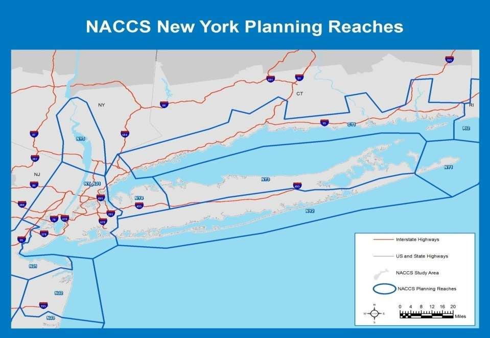
8 38 reaches: Divided by the physical properties of the coastline (either man made or natural) 8
9 9

10 Extent of Inundation 10

11 Extent of Inundation 11

12 Extent of Inundation 12
13 Exposure Assessment Exposure Indices Population density and infrastructure (number of people and infrastructure in communities subject to flooding) Socio-economic groups (populations that may have more difficulty preparing and responding to flooding) Environmental/Cultural (critical habitat, wetlands and other environmental and cultural resources) Mapping Relative higher exposure = highly populated areas and urban centers Boston, NY/northern NJ metropolitan area including Nassau County, Connecticut shoreline, Monmouth and Cape May Counties, the upper Delaware Bay portion of NJ 13

14 Exposure Assessment 14

15 Population & Infrastructure Exposure 15

16 Social Vulnerability Exposure 16

17 Environmental/ Cultural Exposure 17
18 Composite Exposure 18
19 Vulnerability Assessment Greater vulnerability based on proximity to flooding source Exposure * Probability of Flooding Multiply value in each pixel of the composite exposure grid by the probability of flooding Additional metrics would need to be considered at smaller scales 19

20 Vulnerability Assessment 20

21 Structural Storm surge barriers, levees, breakwaters, groins, beach fill, dunes Natural and nature-based features (e.g. living shorelines, wetlands, oyster reefs, Sub-Aquatic Vegetation restoration) Non-Structural Risk Reduction Measures Floodproofing, elevation, acquisition Evacuation, flood warning systems Policy/Programmatic Floodplain management, land use planning State/Local Coastal Zone Policies, Flood Insurance Programs Natural resources/surface water management 21

22 Coastal Risk Reduction and Resilience Measures Measure Definition Effect Examples Natural Created through the action of physical, biological, geologic, and chemical processes operating in nature Shoreline erosion control, wave and surge attenuation, especially in lowenergy environments; additional resilience benefits; dynamic behavior and response affect performance with respect to objectives Barrier islands, dunes, reefs, wetlands, marsh islands and riparian corridors Nature- Based Products of planning, engineering design, and construction incorporating natural processes that contribute to coastal risk reduction and resilience Shoreline erosion control, wave and surge attenuation, especially in lowenergy environments; dynamic behavior and response affect performance with respect to objectives Non- Structural Products of public policy, management and regulatory practices; may include pricing schemes, planning, engineering design, and construction Modify or avoid the impacts of the hazard (vs. modifying the hazard); relatively predictable level of performance with respect to objectives Structure acquisitions or relocations, flood proofing, implementing flood warning systems, flood preparedness planning, land use regulations, development restrictions within the greatest flood hazard areas, elevated development, managed retreat, evacuation, buyout and leaseback Structural Products of planning, engineering design, and construction Shoreline erosion control, wave and surge attenuation, reduced flooding; relatively predictable level of performance with respect to objectives 22 Levees, storm surge barrier seawalls, groins, revetments, and near-shore breakwaters gates,
23 Future Scenarios Climate Change and Sea Level Rise Sea level is increasing throughout the study area Increased populations and infrastructure exposed to storm surge and frequency of flooding Shorelines are changing in response to sea level rise Historic erosion patterns will continue and accelerate Socioeconomic Population is aging (i.e. more difficult to evacuate/relocate during flooding) Population is increasing (more people exposed to flooding) Importance of operating channels and ports will become more critical to regional and national economy Environmental Habitats subject to more stress with population increase, climate change, and other effects 23
24 Future Scenarios Sea level rise* evaluated for the years 2018, 2068, 2100 and 2118 *SLR evaluated using both USACE s Engineer Circular (EC) (low, intermediate high) and NOAA s highest SLR scenarios 24
25 Considerations Advantages Allows for some automation Can be replicated at multiple scales Can identify general areas of interest for further investigation Presents areas of relatively higher exposure/vulnerability Limitations Very coarse analysis Developing weights can be challenging Cannot present site specific issues/solutions Requires consistent datasets 25
26 Schedule Overview Current Status 29 Jan 2013 Quarterly IPR 20 May 13 Public Web Site Quarterly IPR 19 Jul 13 Quarterly IPR 21 Nov 13 Quarterly IPR 18 Feb 14 Quarterly IPR Apr 14 Quarterly IPR Jul 14 Draft Final to HQUSACE Sep 2014 Quarterly IPR Oct 14 PDT Milestone 1 8 May 13 PDT Milestone 2 19 Jun 13 PDT Milestone 3 20 Aug 13 Further Opportunities for Input 28 Jan 2015 Develop draft PMP and SOW (NLT 15 Mar; approved 27 Mar 13) Phase 1 [Months 1-14] Interagency & NGO coordination to assemble existing/future conditions. Assessment & formulation of measures ATR and HQUSACE Review of Draft Analyses Phase 2 [Months 15-18] Interagency & international validation & collaboration Phase 3 [Months 19-24] Finalize comprehensive report & submit to Congress (January 2015) PHASE 1 Products PHASE 2 Products PHASE 3 Products Coastal Geographic Information System Geodatabase & Analysis Sea Level Rise and Vulnerability Assessment & Maps Identification of risk and preliminary approaches for system resilience Align with other Regional Plans Receive interagency, partner and international comments Institutional Barriers Additional Analyses that may be warranted. Storm Suite Modeling Economic Depth- Damage Estimation Tool Submission of final report to Congress 26
Future of our coasts: Potential for natural and hybrid infrastructure to enhance ecosystem and community resilience Ariana Sutton-Grier
 Future of our coasts: Potential for natural and hybrid infrastructure to enhance ecosystem and community resilience Ariana Sutton-Grier University of Maryland & National Oceanic and Atmospheric Administration
The Army Corps of Engineers and the Flood Risk Challenge
 The Army Corps of Engineers and the Flood Risk Challenge Presentation to Association of State Flood Plain Managers Steven L. Stockton, P.E. Director of Civil Works June 12, 2013 US Army Corps of Engineers
Coastal Erosion Risk Mitigation Strategies applied in a Small Island Developing State: The Barbados Model
 Coastal Erosion Risk Mitigation Strategies applied in a Small Island Developing State: The Barbados Model BY Dr. Leo Brewster, Director Coastal Zone Management Unit, Barbados Presented At UNFCCC Expert
Develop hazard mitigation policies and programs designed to reduce the impact of natural and human-caused hazards on people and property.
 6.0 Mitigation Strategy Introduction A mitigation strategy provides participating counties and municipalities in the H-GAC planning area with the basis for action. Based on the findings of the Risk Assessment
Flood Risk Management
 Flood Risk Management Value of Flood Risk Management Every year floods sweep through communities across the United States taking lives, destroying property, shutting down businesses, harming the environment
Flood Risk Management
 Flood Risk Management Value of Flood Risk Management Value to Individuals and Communities Every year floods sweep through communities across the United States taking lives, destroying property, shutting
SARASOTA COUNTY Dedicated to Quality Service
 SARASOTA COUNTY Dedicated to Quality Service Florida Flood Map Updates and the National Flood Insurance Program Joy Duperault, CFM State of Florida NFIP Coordinator Desiree (Des) Companion, CFM CRS Coordinator
STATUS REPORT FOR THE SUBMERGED REEF BALL TM ARTIFICIAL REEF SUBMERGED BREAKWATER BEACH STABILIZATION PROJECT FOR THE GRAND CAYMAN MARRIOTT HOTEL
 STATUS REPORT FOR THE SUBMERGED REEF BALL TM ARTIFICIAL REEF SUBMERGED BREAKWATER BEACH STABILIZATION PROJECT FOR THE GRAND CAYMAN MARRIOTT HOTEL performed by Lee E. Harris, Ph.D., P.E. Consulting Coastal
An Initial Assessment of the Impacts of Sea Level Rise to the California Coast
 An Initial Assessment of the Impacts of Sea Level Rise to the California Coast Photo by D. Revell 2/23/08 California Coastal Records Project Dr. David Revell and Matt Heberger, P.E. Dr. Peter Gleick, Bob
Why should communities invest in resiliency? What are the steps communities can take to become more resilient?
 Community Preparedness for Flood Resiliency Nina Peek, AICP New York Planning Federation Board of Directors Senior Technical Director AKRF, Inc. Focus of Today s Presentation Why should communities invest
Miami-Dade County Roadmap for Adapting to Coastal Risk
 Miami-Dade County Roadmap for Adapting to Coastal Risk Vulnerability Assessment & Planning Workshop Results & Recommendations Roadmap for Adapting to Coastal Risk Page 1 Introduction GreenPrint is Miami-Dade
Ariana Sutton-Grier, Holly Bamford & Kateryna Wowk University of Maryland and National Oceanic and Atmospheric Administration
 Future of our coasts: Potential for natural and hybrid infrastructure Ariana Sutton-Grier, Holly Bamford & Kateryna Wowk University of Maryland and National Oceanic and Atmospheric Administration Green
1. GENERAL ADVISORY BASE FLOOD ELEVATION (ABFE) QUESTIONS
 QUESTIONS") INTRODUCTION As communities begin to recover from the devastating effects of Hurricane Sandy, it is important to recognize lessons learned and to employ mitigation actions that ensure structures are rebuilt
INTRODUCTION As communities begin to recover from the devastating effects of Hurricane Sandy, it is important to recognize lessons learned and to employ mitigation actions that ensure structures are rebuilt
In Coastal Virginia, flooding
 Fall 2012, Vol. 7, No. 2 In Coastal Virginia, flooding has been an on-going issue. Flooding is caused by precipitation events, high tides or storm surge. Although flooding has occurred throughout recorded
Malcolm L. Spaulding Professor Emeritus, Ocean Engineering University of Rhode Island Narragansett, RI 02881
 Malcolm L. Spaulding Professor Emeritus, Ocean Engineering University of Rhode Island Narragansett, RI 02881 USACE Coastal and Hydraulics Laboratory(CHL) Data Infrastructure Workshop January 23, 2014 Overview
Oregon. Climate Change Adaptation Framework
 Oregon Climate Change Adaptation Framework Oregon Environmental Quality Commission Climate Change Adaptation Framework Presentation at a glance: Purposes of the framework Participating agencies Climate
NOAA COASTAL SERVICES CENTER Strategic Plan: 2010 to 2015
 NOAA COASTAL SERVICES CENTER Strategic Plan: 2010 to 2015 N a t i o n a l O c e a n i c a n d A t m o s p h e r i c A d m i n i s t r a t i o n ( N O A A ) C o a s t a l S e r v i c e s C e n t e r March
Monmouth County Preliminary Flood Insurance Study and Flood Insurance Rate Maps Release
 Monmouth County Preliminary Flood Insurance Study and Flood Insurance Rate Maps Release Thomas Song, Program Specialist FEMA Region 2 January 31, 2014 Agenda Introduction Review: Preliminary Work Maps
REQUEST FOR PROPOSAL (RFP) For Consultancy Services
 For Consultancy Services") National Environment & Planning Agency 10 & 11 Caledonia Avenue, Kingston 5, Jamaica W.I. Tel: (876) 754-7540 Fax: (876) 754-7595-6, toll free help-line: 1-888-991-5005 Website: http://www.nepa.gov.jm
National Environment & Planning Agency 10 & 11 Caledonia Avenue, Kingston 5, Jamaica W.I. Tel: (876) 754-7540 Fax: (876) 754-7595-6, toll free help-line: 1-888-991-5005 Website: http://www.nepa.gov.jm
Aligning Natural and Built Infrastructure for
 Aligning Natural and Built Infrastructure for Houston Climate Resilience National Exercise Program (NEP) Houston Climate Change Preparedness & Resilience Workshop Edmond J. Russo, Jr., PhD, PE, D.CE, D.NE,
Predicting Coastal Hazards: A Southern California Demonstration
 Predicting Coastal Hazards: A Southern California Demonstration Patrick Barnard United States Geological Survey Coastal and Marine Geology Team Santa Cruz, CA Southern California Multi-hazards Demonstration
Floodplain 8-Step Process in accordance with Executive Order 11988: Floodplain Management. New Jersey Department of Environmental Protection
 Floodplain 8-Step Process in accordance with Executive Order 11988: Floodplain Management New Jersey Department of Environmental Protection U.S. Department of Housing and Urban Development Community Development
Guideline: A risk assessment approach to development assessment in coastal hazard areas
 Guideline: A risk assessment approach to development assessment in coastal hazard areas Prepared by: Environment Planning, Department of Environment and Heritage Protection State of Queensland, 2013. The
Goal 1 To protect the public health, safety and property from the harmful effects of natural disasters.
 Plan Framework for Coastal Management The purpose of this element is to provide for the protection of residents and property in within the coastal area of the host community, and to limit expenditures,
Designing and Developing WebGIS SLR tools: NJ Floodmapper
 Designing and Developing WebGIS SLR tools: NJ Floodmapper Richard Lathrop, Lisa Auermuller, Jeanne Herb, Marjorie Kaplan, James Trimble, John Bognar & Jennifer Rovito Coastal Community Resiliency Progression
Lower Raritan Watershed Management Area Stormwater & Flooding Subcommittee Strategy Worksheet LRSW-S3C1
 Strategy Name: Reduce Existing Potential for Flood Damages LRSW-S3C1. Develop and implement a program to: Minimize flood damages through the use of structural measures. Minimize flood damages through the
Looking for property near the ocean?
 Looking for property near the ocean? Questions and Answers on Purchasing Coastal Real Estate in Massachusetts This brochure focuses on questions you should ask as a potential purchaser of coastal real
AT&T Global Network Client for Windows Product Support Matrix January 29, 2015
 AT&T Global Network Client for Windows Product Support Matrix January 29, 2015 Product Support Matrix Following is the Product Support Matrix for the AT&T Global Network Client. See the AT&T Global Network
Civil Works - FY 2015 CROmnibus & FY 2016 Budget
 Civil Works - FY 2015 CROmnibus & FY 2016 Budget Mark L. Mazzanti Chief, Programs Integration Division Civil Works Directorate, HQUSACE US Army Corps of Engineers BUILDING STRONG 1 BUILDING STRONG USACE
Sea Level Change. Miami-Dade Sea Level Rise Task Force
 Sea Level Change and LongProgram Range Everglades Restoration Climate Water Resources Planning for Florida Change Application Concerns of USACE andguidance Draft Sea Level on Sea Rise Level Planning Change
MITIGATION STRATEGY OVERVIEW
 ALL-HAZARDS MITIGATION PLAN MITIGATION STRATEGY Code of Federal Regulations (CFR) Requirement 44 CFR Part 201.6(c)(3)(i): The mitigation strategy shall include a description of mitigation goals to reduce
HAZARD VULNERABILITY & RISK ASSESSMENT
 Hazard Vulnerability Analysis Purpose and Scope A Hazard Vulnerability Analysis (HVA) evaluates risk associated with a specific hazard. During this analysis, the hazard is evaluated for its probability
Hurricane and Storm Damage Reduction Study
 FLAGLER COUNTY FLORIDA Hurricane and Storm Damage Reduction Study Updated Project Management Plan - 2010 Presented by Dan Haubner Project Manager U.S. Army Corps of Engineers Jacksonville District R-1
New Coastal Study for Puerto Rico FIRMs. Paul Weberg, FEMA RII Mat Mampara, Dewberry Jeff Gangai, Dewberry Krista Collier, Baker
 New Coastal Study for Puerto Rico FIRMs Paul Weberg, FEMA RII Mat Mampara, Dewberry Jeff Gangai, Dewberry Krista Collier, Baker September 2007 Project Team FEMA Region II Program Manager Collaboration
Association of State Flood Managers Annual Conference Wednesday, June 4, 2014
 Association of State Flood Managers Annual Conference Wednesday, June 4, 2014 Hillsborough County, In the Trenches Local Mitigation Eugene Henry, CFM, AICP Hazard Mitigation Manager Floodplain Administrator
Town of Warwick, Village of Florida, Village of Greenwood Lake and Village of Warwick MULTI JURISIDICTIONAL, MULTI HAZARD MITIGATION PLAN DRAFT
 Town of Warwick, Village of Florida, Village of Greenwood Lake and Village of Warwick MULTI JURISIDICTIONAL, MULTI HAZARD MITIGATION PLAN DRAFT Appendix B Historical Hazard Documentation Rev #0 May 2013
City of Indian Rocks Beach, Florida NFIP Number 125117
 City of Indian Rocks Beach, Florida NFIP Number 125117 Floodplain Management Plan / Local Mitigation Strategy Annual Report - September 2015 Introduction The City of Indian Rocks Beach has been an active
SITE INVESTIGATIONS OF THE BEACH EROSION PROBLEM AT MAHO BEACH, ST. MAARTEN
 SITE INVESTIGATIONS OF THE BEACH EROSION PROBLEM AT MAHO BEACH, ST. MAARTEN Performed February 2003 Performed by: Dr. Lee E. Harris, Ph.D., P.E. Associate Professor of Ocean Engineering & Oceanography
Chapter 6: Mitigation Strategies
 Chapter 6: Mitigation Strategies This section of the Plan describes the most challenging part of any such planning effort the development of a Mitigation Strategy. It is a process of: 1. Setting mitigation
DEPARTMENT OF THE ARMY OFFICE OF THE CHIEF OF ENGINEERS WASHINGTON, D.C. 20314-1000
 DEPARTMENT OF THE ARMY OFFICE OF THE CHIEF OF ENGINEERS WASHINGTON, D.C. 20314-1000 CEMP-SPD (l105-2-10a) APR 1 5 2012 THE SECRETARY OF THE ARMY 1. I submit for transmission to Congress my report on coastal
Flood Risk Management Plans
 Flood Risk Management Plans Main topics of interest and the workshop programme Jos van Alphen 26-01-2010 Content 1. Floods in Europe and related measures 2. The Floods Directive and Flood Risk Management
Facing an Uncertain Future: Increasing Resilience at Marinas and Harbors. Recreational Boating Educational Conference December 11, 2014
 Facing an Uncertain Future: Increasing Resilience at Marinas and Harbors Recreational Boating Educational Conference December 11, 2014 Operators Face Change and Challenges Environmental Conditions Fluctuating
Climate Change Impacts in the Asia/Pacific Region
 Climate Change Impacts in the Asia/Pacific Region Global CC threat CC in the A/P region The Stern Review and IPCC 4 th Assessment Report both state that climate change will have adverse impact on people
FLOOD HAZARD IN THE URBAN ENVIRONMENT: IMPLICATIONS FOR DEVELOPERS, DESIGNERS, AND ATTORNEYS
 FLOOD HAZARD IN THE URBAN ENVIRONMENT: IMPLICATIONS FOR DEVELOPERS, DESIGNERS, AND ATTORNEYS PRESENTED BY: CHAD W. COX, P.E. DANIEL C. STAPLETON, P.E. BOSTON, MA JAN. 24, 2014 PRESENTATION Flood Vulnerability
Using LIDAR to monitor beach changes: Goochs Beach, Kennebunk, Maine
 Geologic Site of the Month February, 2010 Using LIDAR to monitor beach changes: Goochs Beach, Kennebunk, Maine 43 o 20 51.31 N, 70 o 28 54.18 W Text by Peter Slovinsky, Department of Agriculture, Conservation
Federal Emergency Management Agency (FEMA) Preliminary Flood Insurance Rate Maps (FIRMs) and Preliminary Flood Insurance Study (FIS) for New York City
 Preliminary Flood Insurance Rate Maps (FIRMs) and Preliminary Flood Insurance Study (FIS) for New York City") March 10, 2014 Submitted electronically via http://www.nyc.gov Mayor s Office of Long Term Planning and Sustainability c/o Flood Map Comments 253 Broadway, 10th Floor New York, NY 10007 Federal Emergency
March 10, 2014 Submitted electronically via http://www.nyc.gov Mayor s Office of Long Term Planning and Sustainability c/o Flood Map Comments 253 Broadway, 10th Floor New York, NY 10007 Federal Emergency
United States Postal Service Climate Change Adaptation Plan
 United States Postal Service Climate Change Adaptation Plan Version: June 29, 2012 USPS Climate Change Adaptation Plan 1. Introduction...2 2. Policy Framework...3 Vision & Goals...3 Objectives...3 Responsible
DEPARTMENT OF THE ARMY US ARMY CORPS OF ENGINEERS SOUTH ATLANTIC DIVISION 60 FORSYTH ST, SW, ROOM 10M15 ATLANTA, GEORGIA 30303-3490
 DEPARTMENT OF THE ARMY US ARMY CORPS OF ENGINEERS SOUTH ATLANTIC DIVISION 60 FORSYTH ST, SW, ROOM 10M15 ATLANTA, GEORGIA 30303-3490 CESAD-CG REPLY TO ATIENTION OF: 12 Jan 2015 MEMORANDUM FOR Commander,
COMPARISON OF FIXED & VARIABLE RATES (25 YEARS) CHARTERED BANK ADMINISTERED INTEREST RATES - PRIME BUSINESS*
 CHARTERED BANK ADMINISTERED INTEREST RATES - PRIME BUSINESS*") COMPARISON OF FIXED & VARIABLE RATES (25 YEARS) 2 Fixed Rates Variable Rates FIXED RATES OF THE PAST 25 YEARS AVERAGE RESIDENTIAL MORTGAGE LENDING RATE - 5 YEAR* (Per cent) Year Jan Feb Mar Apr May Jun
COMPARISON OF FIXED & VARIABLE RATES (25 YEARS) 2 Fixed Rates Variable Rates FIXED RATES OF THE PAST 25 YEARS AVERAGE RESIDENTIAL MORTGAGE LENDING RATE - 5 YEAR* (Per cent) Year Jan Feb Mar Apr May Jun
Developing Ecosystem Goods and Service Performance Metrics for Natural and Nature-based Infrastructure to Support the NACCS
 Developing Ecosystem Goods and Service Performance Metrics for Natural and Nature-based Infrastructure to Support the NACCS Team: Kelly Burks-Copes (Lead - EL) Sarah Miller (EL) Bruce Pruitt (EL) Deb Shafer
Most informed people realize that cumulative impacts have had
 Welcome to the First Issue of Rivers & Coast! The goal of the new Rivers & Coast newsletter is to keep readers well informed of current scientific understanding behind key environmental issues related
SECTOR ASSESSMENT (SUMMARY): CLIMATE CHANGE. 1. Sector Performance, Problems, and Opportunities
: CLIMATE CHANGE. 1. Sector Performance, Problems, and Opportunities") Climate Resilience Sector Project (RRP TON 46351) Sector Road Map SECTOR ASSESSMENT (SUMMARY): CLIMATE CHANGE 1. Sector Performance, Problems, and Opportunities 1. Tonga is being affected by climate change,
Climate Resilience Sector Project (RRP TON 46351) Sector Road Map SECTOR ASSESSMENT (SUMMARY): CLIMATE CHANGE 1. Sector Performance, Problems, and Opportunities 1. Tonga is being affected by climate change,
South Florida Sea Level Rise Projections and Flood Risk Concerns
 South Florida Sea Level Rise Projections and Flood Risk Concerns MIAMI MIAMI Biscayne Bay Glenn B. Landers, P.E. Planning and Policy Division Jacksonville District EVERGLADES NATIONAL PARK USACE Flood
Essex County, NJ. Preliminary Flood Insurance Study & Flood Insurance Rate Maps Release. FEMA Region 2 May 29, 2014
 Essex County, NJ Preliminary Flood Insurance Study & Flood Insurance Rate Maps Release FEMA Region 2 May 29, 2014 Agenda Introduction Review: Preliminary Work Maps (July 2013) Preliminary Flood Insurance
Community Engagement and Cost Benefit Analysis for Sea Level Rise and Storm Surge Adaptation
 Community Engagement and Cost Benefit Analysis for Sea Level Rise and Storm Surge Adaptation Methods, Case Studies, and Wetland-specific Opportunities Samuel B. Merrill, Ph.D. December 10, 2012 Muskie
Climate Change. Lauma M. Jurkevics - DWR, Southern Region Senior Environmental Scientist
 Climate Change A n o t h e r F a c t o r i n M a n a g i n g S o u t h e r n C a l i f o r n i a s W a t e r R e s o u r c e s Lauma M. Jurkevics - DWR, Southern Region Senior Environmental Scientist USEPA-Region
US Army Corps of Engineers Authorities and Programs
 US Army Corps of Engineers Authorities and Programs Section 206; Flood Plain Management Services Program Section 22; Planning assistance to States General Investigations (large-scale flood risk reduction)
Most Vulnerable US Cities to Storm Surge Flooding. August 2015 2 COPLEY PLACE BOSTON, MA 02116 T: 617.423.2800 F: 617.423.2808
 Most Vulnerable US Cities to Storm Surge Flooding August 2015 2 COPLEY PLACE BOSTON, MA 02116 T: 617.423.2800 F: 617.423.2808 Introduction Hurricane Katrina was a stark reminder that strong winds are only
Rhode Island COASTAL PROPERTY GUIDE. 10 Questions Coastal Residents Need to Ask. FEMA Flood Zones & Flood Insurance
 Rhode Island COASTAL PROPERTY GUIDE WHAT COASTAL PROPERTY OWNERS, RENTERS, BUILDERS AND BUYERS SHOULD KNOW ABOUT RHODE ISLAND S SHORELINE 10 Questions Coastal Residents Need to Ask FEMA Flood Zones & Flood
Sea Level Rise and Coastal Flood Web Tools Comparison Matrix - Oregon GENERAL
 Geographic Scope Organization/Sponsor Link Geographic extent the tool defines or covers (i.e. national, statewide, county ) The organization and/or sponsor of the mapping tool. The URL or link where the
Madison Preliminary Flood Map Open House Community Meeting
 Madison Preliminary Flood Map Open House Community Meeting December 9, 2010 INTRODUCTION Welcome to the Madison County, AL Preliminary Flood Map Open House Meeting The Office of Water Resources (OWR),
Performance Evaluation of New Orleans and Southeast Louisiana Hurricane Protection System. Report 1 Performance Evaluation Plan and Interim Status
 Performance Evaluation of New Orleans and Southeast Louisiana Hurricane Protection System Report 1 Performance Evaluation Plan and Interim Status Interagency Performance Evaluation Task Force (IPET) Products,
Climate Change Long Term Trends and their Implications for Emergency Management August 2011
 Climate Change Long Term Trends and their Implications for Emergency Management August 2011 Overview A significant amount of existing research indicates that the world s climate is changing. Emergency
Flood Damage Mitigation And Insurance Costs
 Flood Damage Mitigation And Insurance Costs Friday, September 25, 2015 at 7:00 PM Saturday, September 26, 2015 at 10:00 AM This presentation was prepared by the Town of South Bethany using Federal Funds
Appendix F Benefit-Cost Analysis of Flood Protection Measures
 Appendix F Benefit-Cost Analysis of Flood Protection Measures Acronyms used in Appendix F: AA B AA C AA D BC BFE EAD FEMA NED O&M PV RED USACE Average Annual Benefits Average Annual Cost Average Annual
ECONOMIC ANALYSIS FLOOD DAMAGE REDUCTION. Lower Carmel River Floodplain Restoration and Enhancement Project
 ECONOMIC ANALYSIS FLOOD DAMAGE REDUCTION Lower Carmel River Floodplain Restoration and Enhancement Project I. Description of the Project and its Relationship to Other Projects in the Proposal The Lower
Empowering State and Local Governments To Redirect Decision-Making to Achieve Resiliency
 Empowering State and Local Governments To Redirect Decision-Making to Achieve Resiliency Recommendations for New Jersey Irene, the October 2011 snowstorm, and most recently Superstorm Sandy were a wake-up
Post-Sandy Municipal Needs Assessment for Long-Term Recovery and Resiliency Planning EXECUTIVE SUMMARY
 Post-Sandy Municipal Needs Assessment for Long-Term Recovery and Resiliency Planning EXECUTIVE SUMMARY Prepared by Nathaly Agosto Filión, Resiliency Manager for the New Jersey Resiliency Network, a program
COASTAL RISK RAPID ASSESSMENT AND FIRST SCORE. MIAMI BEACH CITY HALL 1700 Convention Center Dr., Miami Beach, FL, 33139
 COASTAL RISK RAPID ASSESSMENT AND FIRST SCORE MIAMI BEACH CITY HALL 1700 Convention Center Dr., Miami Beach, FL, 33139 *THIS REPORT IS PROVIDED SUBJECT TO THE COASTAL RISK CONSULTING, LLC, PRINTED DISCLAIMERS
Eastern Connecticut Risk & Vulnerability Assessment Workshop
 Coastal Resilience New York and Connecticut A Tool for Coastal Planning in a Changing World Eastern Connecticut Risk & Vulnerability Assessment Workshop January 11, 2012 Waterford Town Hall - Auditorium
Hurricanes Katrina & Rita Using Mitigation to Rebuild a Safer Gulf Coast
 ASSOCIATION OF STATE FLOODPLAIN MANAGERS, INC. 2809 Fish Hatchery Road Madison, Wisconsin 53713 608-274-0123 Fax: 608-274-0696 Website: www.floods.org Email: asfpm@floods.org Chair Pam Pogue, CFM RI Emergency
Flooding in San Francisco Bay: Risks and Opportunities
 Flooding in San Francisco Bay: Risks and Opportunities Photo Judy Irving Pelican Media Authors Jeffrey Mount, Saracino & Mount LLC Jeremy Lowe, ESA PWA Flooding in San Francisco Bay: Risks and Opportunities
CONSIDERATIONS ON THE POTENTIAL OF INCREASE IN COASTAL VULNERABILITY IN TINHARÉ AND BOIPEBA ISLANDS, BAHIA, BRAZIL, IN FACE OF CLIMATE CHANGE
 CONSIDERATIONS ON THE POTENTIAL OF INCREASE IN COASTAL VULNERABILITY IN TINHARÉ AND BOIPEBA ISLANDS, BAHIA, BRAZIL, IN FACE OF CLIMATE CHANGE Carla I. Elliff & Ruy K. P. Kikuchi Universidade Federal da
Coastal Engineering Indices to Inform Regional Management
 Coastal Engineering Indices to Inform Regional Management Lauren Dunkin FSBPA 14 February 2013 Outline Program overview Standard products Coastal Engineering Index Conclusion and future work US Army Corps
FEMA Takes Action to Implement National Flood Insurance Reform Act
 FEMA Takes Action to Implement National Flood Insurance Reform Act The implementation of the National Flood Insurance Reform Act of 1994 requires a great deal of coordination and support within the Federal
What if Hurricane Sandy made landfall on the SC Coastline???
 What if Hurricane Sandy made landfall on the SC Coastline??? Charlie Kaufman Dorchester County Emergency Management Department Dr. Norm Levine College of Charleston: Lowcountry Hazards Center Background
Los Angeles County. Open Pacific Coast Study. California Coastal Analysis and Mapping Project
 Los Angeles County Open Pacific Coast Study California Coastal Analysis and Mapping Project December 2011 Open Pacific Coast Counties Phase 1 Phase 2 California Coastal Analysis and Mapping Project Risk
SSPEED Center Phase III: Developing a Houston- Galveston Area Protection System (H-GAPS)
") Center Phase III: Developing a Houston- Galveston Area Protection System (H-GAPS) The Center 6100 Main St., MS317 Houston, Texas 77005 June 2, 2014 DPCAC meeting Center Phase I & II Recap (2009-2014) Phase
Center Phase III: Developing a Houston- Galveston Area Protection System (H-GAPS) The Center 6100 Main St., MS317 Houston, Texas 77005 June 2, 2014 DPCAC meeting Center Phase I & II Recap (2009-2014) Phase
Comprehensive Recommendations Supporting the Use of the Multiple Lines of Defense Strategy to Sustain Coastal Louisiana 2008 Report (Version I)
") Comprehensive Recommendations Supporting the Use of the Multiple Lines of Defense Strategy to Sustain Coastal Louisiana 2008 Report (Version I) This report recommends integrated coastal projects and levee
Comprehensive Recommendations Supporting the Use of the Multiple Lines of Defense Strategy to Sustain Coastal Louisiana 2008 Report (Version I) This report recommends integrated coastal projects and levee
COASTAL APPLICATION FOR A MAJOR SITING PERMIT
 Frank M. Rabauliman Administrator Commonwealth of the Northern Mariana Islands OFFICE OF THE GOVERNOR Bureau of Environmental and Coastal Quality Division of Coastal Resources Management Gualo Rai Center
New York Sea Grant Strategic Plan
 New York Sea Grant Strategic Plan Introduction and Process This is the new strategic plan for New York Sea Grant (NYSG) for the years 2010-2013 as requested by the National Sea Grant Office. This plan
minutes I. Summary of Presentation San Francisco County Kick-off Meeting: CCAMP/OPC Study Wednesday, February 23, 2011, 2:00-4:00 PM
 San Francisco County Kick-off Meeting: CCAMP/OPC Study Wednesday, February 23, 2011, 2:00-4:00 PM LOCATION: San Francisco City Hall, Room 370 1 Dr. Carlton B. Goodlett Place San Francisco, CA 94102 ATTENDEES:
Norfolk Flooding Strategy Update. Presentation to Norfolk City Council March 27, 2012
 Norfolk Flooding Strategy Update Presentation to Norfolk City Council March 27, 2012 Presentation Overview The purpose of this presentation is to provide City Council an update on activities carried out
PLANNING FOR POST-DISASTER RECOVERY BRIEFING PAPERS
 10 PLANNING FOR POST-DISASTER RECOVERY BRIEFING PAPERS GREEN INFRASTRUCTURE AND POST-DISASTER RECOVERY At the regional scale, green infrastructure is a network of natural areas and open spaces that provide
HAZUS 2014. 7 th Annual Conference
 HAZUS 2014 7 th Annual Conference HAZUS Comparison of Storm Surge Levels from Different Hurricanes to the Newest SLOSH Models for Berkeley, Charleston, & Dorchester Counties Along the SC Coastline. Charlie
PLANNING FOR POST-DISASTER RECOVERY BRIEFING PAPERS FLOOD INSURANCE AND DESIGN REQUIREMENTS
 06 PLANNING FOR POST-DISASTER RECOVERY BRIEFING PAPERS FLOOD INSURANCE AND DESIGN REQUIREMENTS Flood losses are increasing nationwide. A community may take more than a decade to fully recover from a flood,
Flood Emergency Response Planning: How to Protect Your Business from a Natural Disaster RIC005
 Flood Emergency Response Planning: How to Protect Your Business from a Natural Disaster RIC005 Speakers: Tom Chan, CEO, Global Risk Miyamoto Greg Bates, Principal, Global Risk Consultants Learning Objectives
Natural Disaster Impact on Business and Communities in Taiwan. Dr. Chung-Sheng Lee. NCDR Chinese Taipei
 Natural Disaster Impact on Business and Communities in Taiwan Dr. Chung-Sheng Lee NCDR Chinese Taipei 1 Brief Introduction of NCDR 2 Organizational Chart of NCDR NDPPC: National Disaster Preparation and
Adaptation for City Infrastructure; A Case Study of East Boston, MA
 Adaptation for City Infrastructure; A Case Study of East Boston, MA Paul Kirshen and Thomas Ballestero with support from Kirk Bosma, Wood Hole Group EMF, July 22, 2014 Funded by SARP, OGP, US NOAA Climate
Country overview and assessment
 2. BULGARIA This country fiche provides a comprehensive overview and assessment of climate change adaptation in Bulgaria. After detailing the vulnerability of Bulgaria s coastal zones, the responsibility
Planning Policy and Guidance on Flooding and Coastal Erosion
 Planning Policy and Guidance on Flooding and Coastal Erosion James Hooker (MRTPI) Senior Planning Manager Welsh Government RTPI Cymru - Water and Flooding Seminar Tuesday 20 th November 2012 Overview
Subactivity: Habitat Conservation Program Element: National Wetlands Inventory
 HABITAT CONSERVATION FY 29 BUDGET JUSTIFICATION Subactivity: Habitat Conservation Program Element: National Wetlands Inventory National Wetlands Inventory ($) FTE 27 4,7 2 28 Enacted 5,255 2 Fixed Costs
Pete Slovinsky, Coastal Geologist, Maine Dept. of Agriculture, Conservation and Forestry
 MEGUG WINTER MEETING AGENDA FEB 2 ND, USM WISHCAMPER CENTER PORTLAND, ME 8:30 9:30am Registration and Poster Setup. Coffee, Tea, and Pastry served. 9:30 10am Opening Remarks, Announcements, and Updates
AN INITIATIVE TO IMPROVE
 L OW E R C A R M E L R I V E R A N D L AG O O N F L O O D P L A I N R E S TO R AT I O N A N D E N H A N C E M E N T P R O J E C T AN INITIATIVE TO IMPROVE FLOOD PROTECTION RESTORE AND PROTECT RIPARIAN
c f'f:..-- Risk Identification Branch
 Federal Emergency Management Agency Washington, D.C. 20472 AUG -1 3)05 MEMORANDUM FOR: FROM: c f'f:..-- Risk Identification Branch SUBJECT: Procedure Memorandum No. 37 Protocol for Atlantic and Gulf Coast
Preliminary Views on the Draft Early Restoration Programmatic Environmental Impact Statement and Phase III Early Restoration Plan
 Preliminary Views on the Draft Early Restoration Programmatic Environmental Impact Statement and Phase III Early Restoration Plan The Deepwater Horizon Natural Resource Damage Assessment Trustees (Trustees)
Martin County Coastal GIS Program St Lucie Inlet Planning Tool
 Martin County Coastal GIS Program St Lucie Inlet Planning Tool Alexandra Carvalho, Ph.D., GISP Kathy Fitzpatrick, P.E. Jessica Garland Martin County, Florida Presentation Overview County Coastal Programs
Coastal Restoration Spending in Louisiana Economic Impact Analysis
 Coastal Restoration Spending in Louisiana Economic Impact Analysis Louisiana Workforce Commission www.lmi.laworks.net/green September 2011 In 2009, Louisiana and Mississippi partnered to research economic
9/13/2013. Emergency Management has jurisdiction over the entire county. Requires an emergency management Director.
 9/13/2013 Florida Statute 252 Emergency Management 2006 Christmas Day Tornado Track 2013 Terra Mar Manufactured Home Park Tornado 1998 Wildfire State Road 11 Volusia County Emergency Management Division