Instream Habitat Enhancement
|
|
|
- Katrina Snow
- 7 years ago
- Views:
Transcription

1 Instream Habitat Enhancement Jeremiah D. Bergstrom, CLA, RLA, ASLA Principal-Water Resources 850 Bear Tavern Road, Suite 104 Trenton, NJ Phone: x101
2 Instream Habitat Enhancement Projects that include the placement of wood and stone structure into the stream channel in combination with appropriate plant and/or bioengineering materials for the purposes of enhancing habitat for fish and other aquatic organisms 2
3 Why habitat enhancement? Stream profile and cross section has been altered/straightened due to anthropogenic activities and no longer exhibits habitat complexity suitable for supporting a diverse aquatic ecosystem Embedded substrate does not currently provide suitable habitat for many aquatic invertebrate species Stream reach has incised banks which do not provide instream cover or suitable fish habitat 3
4 Key Design Principles The development of aquatic habitats requires that streams actively experience sediment flushing and depth variations through scouring action. Scouring causes local movement of instream sediments with the primary goal of shifting bedload material a short distance downstream. This shifting of sediments creates the beginning of a meander. As meanders develop in a stream system, gradient decreases and current velocities and sedimentcarrying capacity are reduced. These effects provide for the development of riffles, deeper water (pools) and improved instream cover enhancing aquatic habitat. Project designs should meet the broadest habitat requirements that can be encompassed while still meeting basic objectives and addressing any target species needs. Ecosystem diversity is important. Maintain fish passage. 4
5 Enhancement Objectives Create deeper water reestablish pool habitat Narrow channel width Remove sediment by flushing action reestablish riffles Add cover for fish creating hiding or resting areas Add substrate and food for aquatic organisms throughout addition of woody debris 5
6 Habitat Enhancement Techniques Boulder Placement / Boulder Clusters Revetments and Cover Logs Cribbing Deflectors Small Dams and Channel Control Structures 6
7 Boulder Placement / Boulder Clusters Boulder clusters are groups of large rocks placed in a stream to improve habitat, and create scour holes and areas of reduced velocity. Placing the boulders in the stream creates eddies or vortices in their wake, which create overhead cover for fish by partially diffusing sunlight. Boulder clusters can also generate scour that cause pockets of deeper water to develop, which adds to the physical diversity of the stream (Fischenich and Seal, 1999). 7
8 Boulder Placement / Boulder Clusters Boulders can be used in most stream habitat types including riffles, runs, flats, glides and open pools, but are most effective in wide, shallow streams with gravel or rubble beds. In deep streams, they can provide cover and improve substrate. 8

9 Boulder Placement / Boulder Clusters Evaluations of fish habitat improvement projects have shown a high variability in the benefits of instream boulders. This variability is due to differences in fish seeding levels, species and ages of fish, season of year, the design of the project, time since implementation, and sampling method (Fischenich and Seal 1999). Group placement of boulders is most effective, but individual boulders may be effective in small streams (FISRWG, 1998). 9
10 Boulder Placement / Boulder Clusters Design Considerations The primary design considerations for boulder clusters are a) the number, configuration, and location of the structures, and b) the size of the boulders needed for stability. The hydraulic impacts of the boulders should also be ascertained when habitat benefits must be quantified or the potential exists for adverse impacts due to increased velocities or water surface elevations. For boulder clusters, the greatest benefits are realized in streams with average flows exceeding 2 feet per second. Boulders should not be used near banks susceptible to erosion. The use of boulder clusters is generally limited to streams with coarse gravel (or larger) substrate. It is not recommended for sand bed streams because the boulders have a tendency to become buried. 10
11 Revetments and Cover Logs Revetments and cover logs include the use of brush and woody material secured to the streambank to provide overhead cover for fish and support insect and other fish food organisms. These structures can provide limited streambank protection. Various materials and techniques can be used, but must be securely anchored to avoid becoming dislodged. 11

12 Revetments and Cover Logs Suitable for use in lowgradient stream bends or meanders where open pools are already present Can be used in combination with other techniques Brush and woody materials maximize surface area for both terrestrial and aquatic insect habitat Can be labor intensive to install 12

13 Revetments and Cover Logs Root Wad Cedar Tree Revetment Cover Log 13

14 Revetments and Cover Logs 14

15 Revetments and Cover Logs NOTE: Brush layering is a bioengineering technique that can be used in combination with tree revetments and cover logs 15
16 Cribbing A cribwall is a live log wall, built cribstyle, to protect eroding banks. Vegetation is planted between the logs used to build the wall. The vegetation reduces stream velocities as well as provides cover and shelter for fish. The root structure of the vegetation strengthens the material within the crib. 16

17 Cribbing This technique is useful when slopes are too steep for other techniques of stabilization and there is no room to cut back the slope. Cribwalls are also effective to prevent toe erosion by scouring. Cribwalls do not need to be built up the entire bank. Another bioengineering technique can be installed on the upper bank. Cribwalls should be used for walls four foot high or less and not longer than 20 feet. For successful vegetation establishment ensure that the cuttings are dormant and are installed soon after harvest. The branches should not be allowed to dry out. The cribwall must be constructed during low water period. 17

18 Cribbing Live Timber Crib Wall 18

19 Deflectors Deflectors constrict and divert water flow so that stream meanders and pools are formed by scouring and relocation of fine sediment and gravel 19

20 Deflectors Can be made of logs and/or stone and can rise 6 to 18 inches above normal flows, but should always be less than streambank height. Low-flow stream width can be narrowed up to 70-80% between the tip of the deflector and the streambank to achieve desired results. Stream velocity is reduced as scouring forms a pool extending from the apex of the deflector to the far bank. 20
21 Deflectors Deflectors are built singly to protect an eroding bank, or in pairs to narrow the stream channel. They are placed in a series, positioned alternately, on one bank and then the other to keep the current sweeping swiftly in a natural winding pattern. In nature, pools and riffles normally are repeated every 5 to 7 channel widths; therefore, the distance between deflectors should be at least seven times the average stream width. Deflectors may be constructed entirely of rock, or rock and wire combinations (gabions), or rock framed with logs. Build deflectors in a triangular shape, with the tip pointing downstream and angling out toward the channel. Adjust the angle (usually about 30 degrees between the bank and the deflector) to guide the current into midchannel at a suitable speed. Check the path of the current by throwing a float into the water upstream from the deflector. If the float hits the opposite bank, modify the size or angle of the deflector until the float remains in mid-channel. Deflectors built at an extreme angle (pointed more across than down stream) or too long (more than one half the channel width) may cause erosion on the opposite bank or catch floating debris. Improperly built deflectors receive greater water pressure and may be damaged by floods. Build deflectors low with only a few inches above the water surface at the offshore tip and tapered upward toward the bank. Design deflector height to allow high flows to pass over the top of the structure. Remember, deflectors should guide the current, not dam it! Avoid building deflectors in riffles. Preserve natural riffle areas from any type of disturbance or construction. They are important fish food production and spawning areas. 21

22 Deflectors Single-Wing Deflector Deflector and Cover Log 22

23 Deflectors Single-Wing Deflector & Cover Log Double-Wing Deflector 23

24 Deflectors Double-Wing Deflector NOTE: Double-wing deflectors create midchannel pools through scouring action in shallow sections of streams Single-Wing Deflector & Cover Log NOTE: A cover log ensures bank stability where suitable boulders, tree stumps, or stable banks are lacking 24
25 Small Dams and Channel Control Structures Small dams or structures across a stream can be used to create pools or deeper water through scouring action in shallow sections of streams. In continuous, steep gradients, the short, upstream break in gradient also provides resting area, often holding more fish than does the deeper pool below. The quiet water above the structure and the edges of the pool below also act as a trap for organic material used as food by stream invertebrates. 25
26 Small Dams and Channel Control Structures Any channel control structure requires a detailed investigation of the stream hydraulics and morphology. An intensive design process should be used to thoroughly understand the problem and propose structures that meet project goals and objectives. It is critical to understand the impacts of proposed structures to upstream and downstream areas. Natural channel design principles should be applied when considering the location of channel control structures, including identification of tributary locations, changes in channel evolution type and other significant hydrologic or geomorphic features. 26

27 Small Dams and Channel Control Structures Wedge Dam 27

28 Small Dams and Channel Control Structures Boulder Cross Vane 28

29 Small Dams and Channel Control Structures Log Cross Vane 29

30 Small Dams and Channel Control Structures K-Dam 30

31 Small Dams and Channel Control Structures W-Weir A W-weir is made of very large rock in the shape of a W. The edges of the W are anchored into each bank at the top of the bank or the "bankfull" elevation. The bottom or upstream points of the W are at the stream bottom or thalweg elevation and the top point of the W on the downstream side is at an elevation 1/2 way between the other two. The design was created by David Rosgen of Wildland Hydrology. A W-weir allows river flow to pass through a segment of stable cross section while providing grade control and stream bank protection. 31

32 Small Dams and Channel Control Structures W-Weir SOURCE: Dimondale, Eaton County, Michigan Dam Before Restoration W-Weir After Restoration 32

33 Small Dams and Channel Control Structures Step Pools 33
34 Summary Understand the specific needs of the aquatic species of concern and provide for the broadest range of habitat enhancement Maintain fish passage at all times Use natural materials that are readily available and appropriate to the geologic region and habitat area you are working in Understand the impacts structures will have on upstream and downstream areas Securely anchor all materials appropriately 34
35 Additional References British Columbia, Ministry of Agriculture, Food and Fisheries. Constructued Ditch Fact Sheet, Bio-engineering Techniques. Fischenich, C., and Seal, R Boulder Clusters. U.S. Army Engineer Research and Development Center, Vicksburg, MS. FISRWG Stream Corridor Restoration: Principles, Processes, and Practices. Federal Interagency Stream Restoration Working Group, Houser, D. and Lutz, K Fish Habitat Improvement for Trout Streams. Pennsylvania Fish and Boat Commission Kelly, F Restoration of Urban Streams. United States Department of Agriculture, Massachusetts Nonpoint Source Pollution Management. Boulder Clusters and Rock Riffles Fact Sheet. North Carolina State Cooperative Extension. Fact Sheet Number 4 Using Root Wads and Rock Vanes for Streambank Stabilization. Rosgen, D. The Cross-Vane, W-Weir and J-Hook Vane Structures Their Description, Design and Application for Stream Stabilization and River Restoration. Wildland Hydrology, Inc. Seehorn, M Stream Habitat Improvement Handbook. USDA Forest Service, Technical Publication R8-TP 16. Virginia Cooperative Extension. Landowner's Guide to Managing Streams in the Eastern United States. 35
36 Case Study Pike Run Habitat Enhancement and Restoration Project 36
37 Project Overview This restoration effort proposed instream habitat enhancement and floodplain wetland habitat enhancement through the placement of in-stream structures and native plantings in portions of Montgomery Park. The project team conducted detailed preliminary analyses including stream cross section surveys in accordance with Rosgen stream classification methodologies and have proposed a restoration scenario focusing on improving instream habitat within an approximately 1000 linear foot segment of Pike Run. In addition, large areas of floodplain wetlands currently mowed by the Township and frequented by Canada Geese and other nuisance wildlife populations have been planted with native meadow and woodland species to further expand and enhance the riparian buffer along the stream. 37
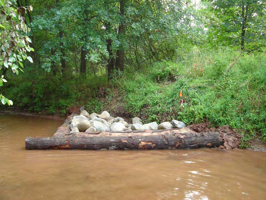
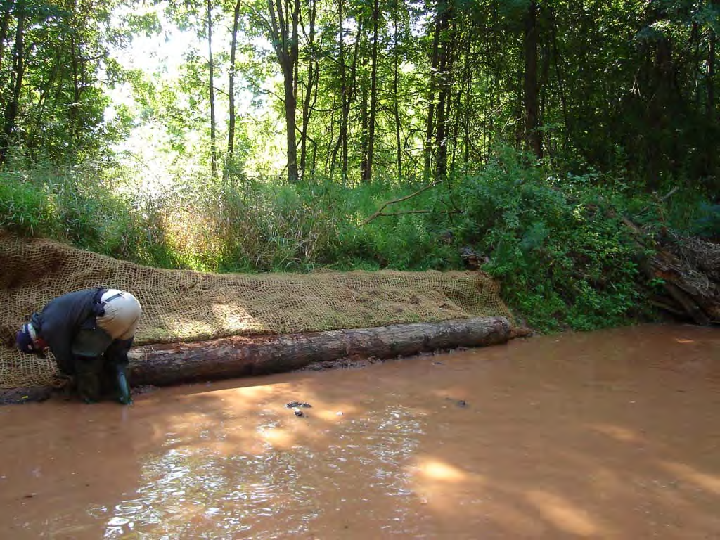
38 Project Objectives The stream substrate in the target section of Pike Run consists of both bedrock and embedded cobbles. The embedded cobbles and bedrock do not currently provide suitable habitat for many aquatic invertebrate species. The reach also has incised banks which do not provide instream cover or suitable fish habitat. The development of aquatic habitats requires that streams actively experience sediment flushing and depth variations through scouring action. Scouring causes local movement of instream sediments with the primary goal of shifting bedload material a short distance downstream. This shifting of sediments creates the beginning of a meander. As meanders develop in a stream system, gradient decreases and current velocities and sediment-carrying capacity are reduced. These effects provide for the development of riffles, deeper water (pools) and improved instream cover enhancing aquatic habitat. The objectives of the project team are to increase the number of riffled areas and pools within the existing stream channel suitable for invertebrates as well as provide more in-stream fish habitat and cover along stream banks. 38

39 Pike Run - Existing Stream Conditions 39

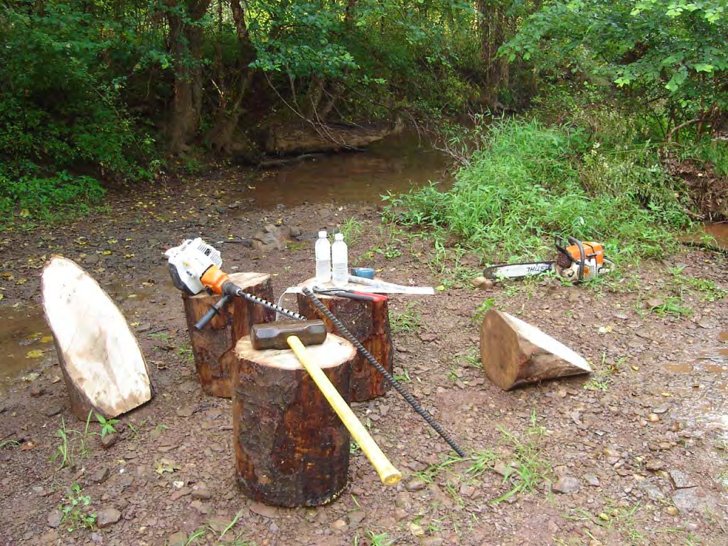
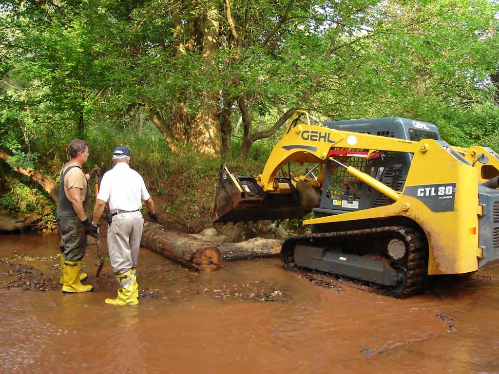
40 Pike Run - Existing Stream Conditions 40

41 Pike Run - Existing Stream Conditions 41

42 Pike Run Study Area Riparian Planting Location in Park Harlingen Road Existing Stream Segment for Structures 42

43 Pike Run Original Design 43

44 Pike Run Original Design 44
45 Pike Run Final Design To achieve the stream enhancement objectives, the project proposes the use of a series of single-wing deflectors and cover logs. These structures constrict and divert water flow during normal flow conditions so that stream meanders, riffles, and pools are formed by scouring and relocation of fine sediment and gravel. The finished structure height of the deflector structures will not be greater than 6 inches above normal flow conditions as to minimize any increases in scour action during storm events while still providing resting and holding areas for aquatic species. Structures will be constructed of logs a minimum of 14 inches in diameter, pinned together at a 90 degree angle and placed at a degree angle to the streambank. The space inside the structure will then be filled with large cobbles or boulders. Waters overtopping the structure will be directed toward the center of the stream and away from streambanks, creating meanders, pools, and riffles within the existing stream bed. To prevent sloughing and reduce current erosion on opposite streambanks, cover logs with stream bank plantings are proposed. In addition to providing protection against potential streambank erosion, the logs and plantings provide addition cover and further enhancement to aquatic habitats in the stream reach. 45
46 Pike Run Final Design 46
47 Pike Run Instream Habitat Enhancement Construction and Installation Photos 47

48 Pike Run - Installation 48

49 49
50 50

51 51
52 52

53 53

54 54

55 55

56 56
57 57

58 58

59 59

60 60

61 61

62 62

63 63

64 64

65 65

66 66

67 67
68 68

69 69

70 70

71 71

72 72

73 73

74 74

75 75

76 76

77 77

78 78
Neversink River East Branch
 Neversink River East Branch Management Unit 10 Summary of Post-Flood Recommendations Intervention Level Full restoration of the stream reach including the eroding bank site between Station 38380 and Station
GLOSSARY OF TERMS CHAPTER 11 WORD DEFINITION SOURCE. Leopold
 CHAPTER 11 GLOSSARY OF TERMS Active Channel The channel that contains the discharge Leopold where channel maintenance is most effective, sediment are actively transported and deposited, and that are capable
The Teton Creek Restoration Project Summary:
 The Teton Creek Restoration Project Summary: The Teton Creek Restoration Project area extends for approximately one mile upstream from the Cemetery Road Bridge and includes the Aspen Pointe, The Aspens
Flood Hazard Area Technical Manual Section 8 Bank Stabilization and Stream Restoration
 Flood Hazard Area Technical Manual Section 8 Bank Stabilization and Stream Restoration Prepared by: New Jersey Section American Water Resources Association Stream Restoration Committee FHA Subcommittee
BRIDGES ARE relatively expensive but often are
 Chapter 10 Bridges Chapter 10 Bridges Bridg Bridges -- usually the best, but most expensive drainage crossing structure. Protect bridges against scour. BRIDGES ARE relatively expensive but often are the
CITY UTILITIES DESIGN STANDARDS MANUAL
 CITY UTILITIES DESIGN STANDARDS MANUAL Book 2 (SW) SW9 June 2015 SW9.01 Purpose This Chapter provides information for the design of open channels for the conveyance of stormwater in the City of Fort Wayne.
Chapter 3 CULVERTS. Description. Importance to Maintenance & Water Quality. Culvert Profile
 Chapter 3 CULVERTS Description A culvert is a closed conduit used to convey water from one area to another, usually from one side of a road to the other side. Importance to Maintenance & Water Quality
Stream Rehabilitation Concepts, Guidelines and Examples. Objectives. Pierre Y. Julien. Three Laws of Stream Restoration
 Stream Rehabilitation Concepts, Guidelines and Examples Pierre Y. Julien Wuhan 2005 Objectives Part I - Stream restoration and rehabilitation: 1. Present and discuss important concepts, laws, criteria
1.7.0 Floodplain Modification Criteria
 1.7.0 Floodplain Modification Criteria 1.7.1 Introduction These guidelines set out standards for evaluating and processing proposed modifications of the 100- year floodplain with the following objectives:
SECTION 5.4 LOGJAM REMOVAL AND RIVER RESTORATION. Overview. Logjam Removal Using Heavy. Tools. Machinery. Large-Scale River Restoration
 SECTION 5.4 LOGJAM REMOVAL AND RIVER RESTORATION Overview Practice 401 Practice 402 Practice 403 Logjam Removal Using Hand-held Tools Logjam Removal Using Heavy Machinery Large-Scale River Restoration
RIPRAP From Massachusetts Erosion and Sediment Control Guidelines for Urban and Suburban Areas http://www.mass.gov/dep/water/laws/policies.
 RIPRAP From Massachusetts Erosion and Sediment Control Guidelines for Urban and Suburban Areas http://www.mass.gov/dep/water/laws/policies.htm#storm Definition: A permanent, erosion-resistant ground cover
Stream Restoration Post-Implementation Annual Monitoring Report Year 2: 2013 Covering the Period of July 2012 to July 2013
 NCDA&CS - North Carolina Forest Service Stream Restoration Post-Implementation Annual Monitoring Report Year 2: 2013 Covering the Period of July 2012 to July 2013 For the N.C. Division of Water Quality
Sand and Silt Removal from Salmonid Streams
 Sand and Silt Removal from Salmonid Streams Stream bank erosion Poor land use practices Sources of Sand and Silt Impacts of Sand and Silt Interstitial spaces infilled Little or no flow through the streambed
Outlet stabilization structure
 Overview of Sedimentation and Erosion Control Practices Practice no. 6.41 Outlet stabilization structure Erosion at the outlet of channels, culverts, and other structures is common, and can cause structural
Final Report. Dixie Creek Restoration Project. Funded by Plumas Watershed Forum
 Final Report Dixie Creek Restoration Project Funded by Plumas Watershed Forum Plumas Corporation January 2009 1 Background FR-CRM staff presented this project to the Dixie Valley Landowners Association
General Permit for Activities Promoting Waterway - Floodplain Connectivity [working title]
![General Permit for Activities Promoting Waterway - Floodplain Connectivity [working title]](/thumbs/39/18645965.jpg "General Permit for Activities Promoting Waterway - Floodplain Connectivity [working title]") General Permit for Activities Promoting Waterway - Floodplain Connectivity [working title] Purpose These rules set forth the conditions under which a person may, without an individual removal-fill permit
General Permit for Activities Promoting Waterway - Floodplain Connectivity [working title] Purpose These rules set forth the conditions under which a person may, without an individual removal-fill permit
 Coldwater Heritage Partnership Implementation Grant Final Report Morrison Run Watershed Restoration Project Western Pennsylvania Conservancy Project Summary The goal of the Morrison Run Watershed Restoration
Various options are discussed below.these low cost, low impact interventions can also be applied as general erosion control methods.
 Week 10 River Hydraulics Rehabilitating Urban Waterways (From http://hubpages.com/hub/river-bank-erosion-control-methods) See also the resources placed on Moodle. Water channels should be viewed as a resource
Appendix C. Project Opportunities. Middle Twisp River (RM 7.8 18.12)
") Appendix C Project Opportunities Middle Twisp River (RM 7.8 18.12) This table describes project opportunities by project area. Locator maps of the project opportunities are included below the table. Reach
Appendix C Project Opportunities Middle Twisp River (RM 7.8 18.12) This table describes project opportunities by project area. Locator maps of the project opportunities are included below the table. Reach
CHAPTER 3A Environmental Guidelines for STREAM CROSSING BY ALL-TERRAIN VEHICLES
 GOVERNMENT OF NEWFOUNDLAND AND LABRADOR DEPARTMENT OF ENVIRONMENT AND LABOUR CHAPTER 3A Environmental Guidelines for STREAM CROSSING BY ALL-TERRAIN VEHICLES WATER RESOURCES MANAGEMENT DIVISION Water Investigations
How To Check For Scour At A Bridge
 Case Studies Bridge Scour Inspection and Repair Edward P. Foltyn, P.E. Senior Hydraulic Engineer ODOT Bridge Unit 2013 PNW Bridge Inspectors Conference April 2013 REFERENCES Stream Stability at Highway
A Stream Restoration Case Study in the California Central Coast
 International Erosion Control Association Annual Conference 2009, Reno, Nevada Case Study Technical Presentation A Stream Restoration Case Study in the California Central Coast Justin S. Rogers, P.E.,
How To Plan A Buffer Zone
 Backyard Buffers Protecting Habitat and Water Quality What is a buffer? A buffer (also called a riparian buffer area or zone) is the strip of natural vegetation along the bank of a stream, lake or other
River Wensum Restoration Strategy Swanton Morley Restoration Scheme Reach 14a
 River Wensum Restoration Strategy Swanton Morley Restoration Scheme Reach 14a At a glance River restoration benefits: Improved planform, channel cross-section, flow variation and sediment process. Improved
COMPLIANCE REPORT MUDDY HOLLOW CULVERT REMOVAL FILE NUMBER 25358N
 COMPLIANCE REPORT MUDDY HOLLOW CULVERT REMOVAL FILE NUMBER 25358N Submitted by the National Park Service Point Reyes National Seashore Point Reyes Station, California, 94956 Project Description: Muddy
Emergency Spillways (Sediment basins)
") Emergency Spillways (Sediment basins) DRAINAGE CONTROL TECHNIQUE Low Gradient Velocity Control Short-Term Steep Gradient Channel Lining Medium-Long Term Outlet Control Soil Treatment Permanent [1] [1]
Emergency Spillways (Sediment basins) DRAINAGE CONTROL TECHNIQUE Low Gradient Velocity Control Short-Term Steep Gradient Channel Lining Medium-Long Term Outlet Control Soil Treatment Permanent [1] [1]
Streambank stabilization, streambank fencing, nuisance species control, riparian zone management
 Streambank stabilization, streambank fencing, nuisance species control, riparian zone management Stream Habitat Restoration Cost Considerations MARK COCKE, Civil Engineer Natural Resources Conservation
Fish & Boat Commission
 P E N N S Y L V A N I A Fish & Boat Commission Habitat Improvement F O R T R O U T S T R E A M S PREPARED BY: Karl J. Lutz Habitat Management Division Pennsylvania Fish & Boat Commission DRAWINGS BY: Carey
Prattsville Berm Removal Project. 1.0 Project Location
 Prattsville Berm Removal Project 1.0 Project Location The project site is located between the New York State Route 23 Bridge over the Schoharie Creek and the Schoharie Reservoir. The restoration plan encompassed
Interim Technical Guidelines for the Development of Environmental Management Plans for Underground Infrastructure Revised - July 2013.
 Interim Technical Guidelines for the Development of Environmental Management Plans for Underground Infrastructure Revised - July 2013 Rationale Underground infrastructure may be at risk from valley, streambank
Ruby River Grayling - Gravel Spawning Beds Monitoring Report January 2008
 Ruby River Grayling - Gravel Spawning Beds Monitoring Report January 2008 In partnership with Montana Department of Fish, Wildlife, and Parks (FWP), American Wildlands, and Wildlife Forever, the Madison
Index. protection. excavated drop inlet protection (Temporary) 6.50.1 6.51.1. Block and gravel inlet Protection (Temporary) 6.52.1
 6.50.1 6.51.1. Block and gravel inlet Protection (Temporary) 6.52.1") 6 Index inlet protection excavated drop inlet protection (Temporary) 6.50.1 HARDWARE CLOTH AND GRAVEL INLET PROTECTION Block and gravel inlet Protection (Temporary) sod drop inlet protection ROCK DOUGHNUT
6 Index inlet protection excavated drop inlet protection (Temporary) 6.50.1 HARDWARE CLOTH AND GRAVEL INLET PROTECTION Block and gravel inlet Protection (Temporary) sod drop inlet protection ROCK DOUGHNUT
Prepared By: Tom Parker Geum Environmental Consulting, Inc.
 Prepared By: Tom Parker Geum Environmental Consulting, Inc. Topics covered: Definition of riparian and floodplain restoration Floodplain attributes as a basis for developing criteria for restoration designs
Year 2 7-15-10 Post Restoration Monitoring Summary Rock Creek Project Monitoring and Analysis conducted by Bio-Surveys,LLC. Contact: strask@casco.
 Year 2 7-15-10 Post Restoration Monitoring Summary Rock Creek Project Monitoring and Analysis conducted by Bio-Surveys,LLC. Contact: strask@casco.net Project Sponsors include: The City of Corvallis Oregon
Mission Creek Flood Control & Restoration Project. City of Fremont, Alameda County
 Mission Creek Flood Control & Restoration Project City of Fremont, Alameda County Agenda Background Why are proposed improvements necessary? Proposed project components Challenges Construction schedule/phasing
Monitoring the Benefits of Instream Habitat Diversity. Entiat River, Chelan County, Washington
 Monitoring the Benefits of Instream Habitat Diversity Entiat River, Chelan County, Washington Bureau of Reclamation Bonneville Power Administration May 2013 This is an update of the report that first occurred
Floodplain Connectivity in Restoration Design
 Floodplain Connectivity in Restoration Design 2015 Symposium on Restoration in a Contaminated Environment: Lessons Learned and Challenges in Moving Forward Part II April 2015 Karin Boyd Applied Geomorphology,
Earth Science. River Systems and Landforms GEOGRAPHY 1710. The Hydrologic Cycle. Introduction. Running Water. Chapter 14.
 Earth Science GEOGRAPHY 1710 River Systems and Landforms DAVID R. SALLEE Robert W. Christopherson Charlie Thomsen Chapter 14 Introduction Rivers and streams are dynamic systems that continually adjust
Plumas Watershed Forum. Review of Ongoing Projects. Updated 10/1/008
 Plumas Watershed Forum Review of Ongoing Projects Updated 10/1/008 Hosselkus II Restoration Project Approved Funding: $80,000 (A funds) Expended By 10/1/08: $79,603 This pond-and-plug creek restoration
Engineering in the water environment: good practice guide. River crossings
 Engineering in the water environment: good practice guide River crossings Second edition, November 2010 Contents 1 Introduction 3 2 Impacts of crossings 5 2.1 Construction phase impacts 5 2.2 Barrier to
Miquon Creek STREAM RESTORATION PROJECT WHO WE ARE
 Miquon Creek STREAM RESTORATION PROJECT WHO WE ARE Introductions Brett Long, PE Project Permitting & Construction Oversight Chris Streb, PE Project Designer & Construction Oversight Assistance WHO WE ARE
STREAM NOTES To Aid in Securing Favorable Conditions of Water Flows
 STREAM SYSTEMS TECHNOLOGY CENTER STREAM NOTES To Aid in Securing Favorable Conditions of Water Flows July 1997 Applying a Fluvial Geomorphic Classification System to Watershed Restoration Terry Benoit
Catchment Scale Processes and River Restoration. Dr Jenny Mant Jenny@therrc.co.uk. The River Restoration Centre therrc.co.uk
 Catchment Scale Processes and River Restoration Dr Jenny Mant Jenny@therrc.co.uk The River Restoration Centre therrc.co.uk 3 Main Catchment Elements Hydrology Energy associated with the flow of water affects
Appendix H Dredging and Stream Channel Restoration
 Appendix H Dredging and Stream Channel Restoration Mankind s intrusion into the natural environment in West Virginia began in earnest following the Civil War when extractive industries and settlement all
Crossing creeks Stream crossings on farms
 Crossing creeks Stream crossings on farms Looking after all our water needs Crossing creeks Stream crossings on farms Looking after all our water needs Department of Water 168 St Georges Terrace Perth
Rhode Island NRCS received approximately $2.4 million in ARRA funds to implement four floodplain easement projects.
 American Recovery and Reinvestment Act (ARRA) Emergency Watershed Protection Program Floodplain Easements Rhode Island Natural Resources Conservation Service Rhode Island NRCS received approximately $2.4
Thank you to all of our 2015 sponsors: Media Partner
 Thank you to all of our 2015 sponsors: Media Partner Channel Naturalization: Planning and Implementation in Peel Region TRIECA March 25 & 26, 2015 Peel Region Channel Remediation Strategy An Urban Context
Gold Ray Dam Interagency Technical Team Meeting
 Gold Ray Dam Interagency Technical Team Meeting Agenda Public Outreach, Funding, Monitoring EA/BA/Permit Updates Deconstruction Plans Fish Passage & Salvage Plan Hydraulic Modeling Next Steps Public Outreach,
Small Dam Hazard Assessment Inventory
 Small Dam Hazard Assessment Inventory What would happen if your dam were to fail? This is a question that most dam owners hope they will never have to answer. However it is a question you, as a responsible
DRAFT SOUTH FORK SKYKOMISH RIVER
 DRAFT SOUTH FORK SKYKOMISH RIVER 9 levees and revetments / Approximately 1.1 miles of river bank are armored Revetments provide limited, localized erosion protection, but impact habitat Frequent and costly
Basic Principles of Channel Design
 United States Department of Agriculture Natural Resources Conservation Service Stream Restoration Design Chapter 7 Basic Principles of Channel Design Issued August 2007 Cover photo: Where modification
Assessing Rivers for Restoration Purposes. Ann L. Riley Waterways Restoration Institute
 Assessing Rivers for Restoration Purposes Ann L. Riley Waterways Restoration Institute Assessing Rivers for Restoration Purposes Ann L. Riley Waterways Restoration Institute Assessing Rivers for Restoration
Environmental Case Study Decatur, Georgia, DeKalb County A Suburban Creek Resists Channelization
 Introduction A visual examination of Doolittle Creek in a highly developed suburban county in Georgia yielded telltale signs of a creek whose original streambed had been altered. Examination of official
Urban Stream Restoration Implementation Auburn, AL March 13-14
 Urban Stream Restoration Implementation Auburn, AL March 13-14 Thank you sponsors and partners: City of Auburn, Alabama Department of Transportation, Alabama Department of Environmental Management, Auburn
DANIELS RUN STREAM RESTORATION, FAIRFAX, VIRGINIA: FLOODPLAIN ANALYSIS REPORT
 DANIELS RUN STREAM RESTORATION, FAIRFAX, VIRGINIA: FLOODPLAIN ANALYSIS REPORT By: Conor C. Shea Stream Habitat Assessment and Restoration Program U.S. Fish and Wildlife Service CBFO-S07-01 Prepared in
The students will be working in and alongside the stream, so safety is a consideration. Suitable sites should have the following characteristics:
 Measuring Stream Banks: Height and Slope Stream bank heights and slopes are of interest because they yield information relevant to bank erosion and stability. A high, steep bank is likely to be unstable
Concepts for Post Flood River Corridor Restoration
 Concepts for Post-Flood River Corridor Restoration Dave Rosgen, P.H., Ph.D. Wildland Hydrology Fort Collins, Colorado A Special Thanks to our Sponsors: Copyright 2014 Wildland Hydrology 1 Workshop Goals
Napa River Restoration Projects
 Napa River Restoration Projects Shaun Horne, Napa County, shaun.horne@countyofnapa.org Jeremy Sarrow, Napa County, jermy.sarrow@countyofnapa.org The Napa River flows though one of the most scenic landscapes
EMERGENCY HOME PROTECTION. Homeowner's Guide for Emergency Flood Control. Contents INTRODUCTION
 EMERGENCY HOME PROTECTION Homeowner's Guide for Emergency Flood Control Contents Discussion or Section Page Number Introduction 3 Potential Flooding Periods 4 General Rules and Control Aids 5,6 Sandbags
The Basics of Chapter 105 Waterways and Wetlands Permitting in PA
 The Basics of Chapter 105 Waterways and Wetlands Permitting in PA April 17, 2013 Goal To develop a basic understanding of PA Department of Environmental Protection (DEP) and US Army Corps of Engineers
HCP Team Meeting. November 18, 2015. icfi.com
 HCP Team Meeting November 18, 2015 icfi.com 1 Welcome and Introductions Where are we in the HCP process Hydrology modeling update Native fish survey Fish translocation Finalize covered activities Next
Rural Flooding: The Potential Role of Forestry
 Rural Flooding: The Potential Role of Forestry Nadeem Shah, Tom Nisbet, & Huw Thomas Centre for Forestry and Climate Change Structure Background Woodland and Flood Alleviation The Theory. Studies on Woodland
a. For all activities that would result in the discharge of fill material into any vernal pool;
 Final Sacramento District Nationwide Permit Regional Conditions for Nevada and the Lake Tahoe Basin in California (Effective March 19, 2012 until March 18, 2017) 1.* When pre-construction notification
Watershed Works Manual
 National Rural Employment Guarantee Act Watershed Works Manual DRAINAGE LINE TREATMENT: GABION STRUCTURE Baba Amte Centre for People s Empowerment Samaj Pragati Sahayog September 2006 Drainage Line Treatment:
1 Introduction. 1.1 Key objective. 1.2 Why the South Esk
 1 Introduction 1.1 Key objective The aim of this study is to identify and assess possible options for improving the quality of the river channel and habitats in the River South Esk catchment whilst helping
City of Shelbyville Site Inspection Checklist
 City of Shelbyville Site Inspection Checklist General Information Project Name: KYR10 Permit Number: Date: Project Location: Contractor: Conractor Representative: Inspector's Name: Title: Signature : Weather
COASTAL DAMAGE INSPECTION SOUTHWEST VITI LEVU, FIJI AFTER CYCLONE SINA
 COASTAL DAMAGE INSPECTION SOUTHWEST VITI LEVU, FIJI AFTER CYCLONE SINA Brendan J. Holden SOPAC Technical Secretariat July 1992 SOPAC Technical Report 148 Prepared for: South Pacific Applied Geoscience
3. Design Procedures. Design Procedures. Introduction
 Design Procedures 3. Design Procedures Introduction This chapter presents a procedure for the design of natural channels. The chapter primarily focuses on those physical properties of the channel required
Backyard Buffers that Work for People and Nature by Restoring Ecological Function
 Backyard Buffers that Work for People and Nature by Restoring Ecological Function What is a Wetland Buffer? A wetland buffer is a simple land management practice that is employed by municipalities to protect
Basic Hydrology. Time of Concentration Methodology
 Basic Hydrology Time of Concentration Methodology By: Paul Schiariti, P.E., CPESC Mercer County Soil Conservation District What is the Time of Concentration? The time it takes for runoff to travel from
SECTION 5. Sediment Control Measures
 SECTION 5 Sediment Control Measures 60. STORM DRAIN INLET PROTECTION When Runoff from earth change activities will discharge to a catch basin or storm drain inlet. A newly constructed catch basin or storm
LATEST ENHANCEMENTS TO THE RIVERMorph STREAM RESTORATION SOFTWARE
 LATEST ENHANCEMENTS TO THE RIVERMorph STREAM RESTORATION SOFTWARE J. George Athanasakes, PE RIVERMorph, LLC 1901 Nelson Miller Parkway Louisville, KY 40223-2177 233 BIOGRAPHICAL SKETCH J. George Athanasakes,
Adopted 9/23/98 CHATTAHOOCHEE CORRIDOR PLAN. The goals of the Chattahoochee Corridor Plan (hereinafter also referred to as the Plan ) are:
 are:") CHATTAHOOCHEE CORRIDOR PLAN Adopted 9/23/98 PART 1: GOALS. POLICY. COVERAGE. A. Goals The goals of the Chattahoochee Corridor Plan (hereinafter also referred to as the Plan ) are: 1. Preservation and protection
CHATTAHOOCHEE CORRIDOR PLAN Adopted 9/23/98 PART 1: GOALS. POLICY. COVERAGE. A. Goals The goals of the Chattahoochee Corridor Plan (hereinafter also referred to as the Plan ) are: 1. Preservation and protection
Big Thompson River Restoration Coalition Best Practice Recommendations and Resources for river front land owners impacted by the flood.
 Big Thompson River Restoration Coalition Best Practice Recommendations and Resources for river front land owners impacted by the flood. The Big Thompson River Restoration Coalition (BTRRC) is a group of
Flood Plain Reclamation to Enhance Resiliency Conserving Land in Urban New Jersey
 Flood Plain Reclamation to Enhance Resiliency Conserving Land in Urban New Jersey Rutgers Cooperative Extension Water Resources Program Christopher C. Obropta, Ph.D., P.E. Email: obropta@envsci.rutgers.edu
FINAL. Ecological Restoration Monitoring Plan Habitat Restoration Design Projects St. Clair River Area of Concern, Michigan
 FINAL Ecological Restoration Monitoring Plan Great Lakes Architect-Engineer Services Contract: EP-R5-11-10 Task Order: 0011 Prepared for U.S. Environmental Protection Agency Region 5 77 West Jackson Boulevard
MULTI-AGENCY COMPENSATORY MITIGATION PLAN CHECKLIST 1
 MULTI-AGENCY COMPENSATORY MITIGATION PLAN CHECKLIST 1 Mitigation Goals and Objectives o Describe functions lost at impact site o Describe functions to be gained at mitigation site o Describe overall watershed
Welded Mesh Gabions and Mattresses River Protection Design Guide HY-TEN GABION SOLUTIONS Dunstall Hill Trading Estate, Gorsebrook Road,
 Welded Mesh Gabions and Mattresses River Protection Design Guide HY-TEN GABION SOLUTIONS Dunstall Hill Trading Estate, Gorsebrook Road, Wolverhampton, WV6 0PJ Tel 01902 712200 Fax 01902 714096 e-mail sales@hy-tengabions.com
Streambank stabilization, streambank fencing, nuisance species control, riparian zone management
 Streambank stabilization, streambank fencing, nuisance species control, riparian zone management Stream Restoration Cost Estimates BRIAN BAIR USDA Forest Service Gifford-Pinchot National Forest 1262 Hemlock
Estabrook Dam A Discussion of Alternatives. Public Scoping Meeting June 5, 2014
 Estabrook Dam A Discussion of Alternatives Public Scoping Meeting June 5, 2014 Presenters Kevin Haley, PLA, Milwaukee County Don Pirrung, P.E., PH, AECOM Mike Hahn, P.E., PH, Southeastern Wisconsin Regional
CHAPTER 5 OPEN CHANNEL HYDROLOGY
 5.4 Uniform Flow Calculations 5.4.1 Design Charts CHAPTER 5 OPEN CHANNEL HYDROLOGY Following is a discussion of the equations that can be used for the design and analysis of open channel flow. The Federal
Part Two Critical Areas
 Part Two Critical Areas Flood Hazard Areas Fact Sheet Components of flood hazard areas Reference CAO Sections 137, 161, 162, 163, 164, 165, 166 Flood hazard areas are composed of: 1. Floodplain; 2. Zero-rise
RESTORING streams to reduce flood loss
 RESTORING streams to reduce flood loss Flood Loss Reduction the Natural Way Flood disasters have become a regular Floods can devastate local occurrence. One in your community may have communities. threatened
Post-Wildfire Clean-Up and Response in Houston Toad Habitat Best Management Practices
 Post-Wildfire Clean-Up and Response in Houston Toad Habitat Best Management Practices Purpose The purpose of this document is to provide guidance and recommendations for minimizing potential impacts to
Nipigon Bay. Area of Concern Status of Beneficial Use Impairments September 2010
 Nipigon Bay Area of Concern Status of Beneficial Use Impairments September 2010 Nipigon Bay is in the most northerly area of Lake Superior. The Area of Concern takes in a large portion of Nipigon Bay and
2.0 BASIC CONCEPTS OF OPEN CHANNEL FLOW MEASUREMENT
 2.0 BASIC CONCEPTS OF OPEN CHANNEL FLOW MEASUREMENT Open channel flow is defined as flow in any channel where the liquid flows with a free surface. Open channel flow is not under pressure; gravity is the
PRIVATE TREATMENT CONTROL BMP OPERATION AND MAINTENANCE VERIFICATION FORM BIORETENTION FACILITIES, VEGETATED SWALES & HIGHER RATE BIOFILTERS
 BIORETENTION FACILITIES, VEGETATED SWALES & HIGHER RATE BIOFILTERS Check here for Address or phone number change the fiscal year (July 1 June 30), and date(s) maintenance was performed. Under Inspection,
SCHNEIDER CREEK REMEDIATION CLASS ENVIRONMENTAL ASSESSMENT ADDENDUM
 SCHNEIDER CREEK REMEDIATION CLASS ENVIRONMENTAL ASSESSMENT ADDENDUM PUBLIC MEETING FEBRUARY 8 TH, 2012 The City of Kitchener and Grand River Conservation Authority (GRCA) are undertaking an Environmental
Riprap-lined Swale (RS)
") Riprap-lined Swale (RS) Practice Description A riprap-lined swale is a natural or constructed channel with an erosion-resistant rock lining designed to carry concentrated runoff to a stable outlet. This
Riprap-lined Swale (RS) Practice Description A riprap-lined swale is a natural or constructed channel with an erosion-resistant rock lining designed to carry concentrated runoff to a stable outlet. This
Photo Credit: Geoff Brosseau
 Objectives Contain Educate Reduce/Minimize Description As a consequence of its function, the stormwater conveyance system collects and transports urban runoff that may contain certain pollutants. Maintaining
SUSTAINABLE URBAN DRAINAGE SYSTEMS
 overflow can lead into a permeable conveyance system to increase further the benefit and reduce the need for pipe systems. Pollutant removal rates have been shown to be high, with some pollutants being
Mission Reach Self-Guided Tour Mission Concepción Portal Loop and Mission Reach Phase II Embayment Loop
 Mission Reach Self-Guided Tour Mission Concepción Portal Loop and Mission Reach Phase II Embayment Loop Welcome to the Mission Reach! The Mission Reach Ecosystem Restoration and Recreation Project is transforming
Restoring Anadromous Fish Habitat in Big Canyon Creek Watershed. Summary Report 2002
 Restoring Anadromous Fish Habitat in Big Canyon Creek Watershed Summary Report 2002 DOE/BP-00005268-5 November 2002 This Document should be cited as follows: "Restoring Anadromous Fish Habitat in Big Canyon
Land Disturbance, Erosion Control and Stormwater Management Checklist. Walworth County Land Conservation Department
 Land Disturbance, Erosion Control and Stormwater Management Checklist Walworth County Land Conservation Department The following checklist is designed to assist the applicant in complying with the Walworth
Habitat Quality, Rainbow Trout Occurrence, and Steelhead Recovery Potential Upstream of Searsville Dam
 Habitat Quality, Rainbow Trout Occurrence, and Steelhead Recovery Potential Upstream of Searsville Dam Prepared by: Matt Stoecker Biologist Owner Stoecker Ecological December 19, 2014 Table of Contents
5.0 OVERVIEW OF FLOOD DAMAGE REDUCTION MEASURES
 5.0 OVERVIEW OF FLOOD DAMAGE REDUCTION MEASURES Flood damage reduction consists of two basic techniques structural and non-structural. Structural methods modify the flood and take the flood away from people
Accretion Sediments carried by a stream and deposited along banks or surrounding areas.
 GLOSSARY Accretion Sediments carried by a stream and deposited along banks or surrounding areas. Acre-foot A quantity or volume of water covering one acre to a depth of one foot (43,560 cubic feet). Active
What Is Rehabilitation?
 Location of Aggregate Operations Ready Mix Plant Locations Aggregate Locations Cement Terminal Locations What Is Rehabilitation? Rehabilitation is the treatment of land from which aggregate has been excavated
Baltimore County Stream Restoration Improves Quality of Life
 Baltimore County Stream Restoration Improves Quality of Life Baltimore County, Maryland, faces a challenge common to most areas experiencing urban growth: how to keep its waterways stable and healthy for
Improving the physical condition of Scotland s water environment. A supplementary plan for the river basin management plans
 Improving the physical condition of Scotland s water environment A supplementary plan for the river basin management plans Contents Executive summary... 2 1. Introduction... 3 2. Vision... 4 3. Taking