Regional Importance of Tennessee and Cumberland Basin Reservoir Systems
|
|
|
- Trevor Carr
- 7 years ago
- Views:
Transcription

1 Regional Importance of Tennessee and Cumberland Basin Reservoir Systems William M. Wilson, P.E. Deputy District Engineer for Project Management Nashville District Corps of Engineers 12 August 2015 US Army Corps of Engineers
2 Purpose and Goal The purpose of this Nashville District Water Management Brief is to inform you about: - Competing demands for water - Ability to moderate flows - Response to extreme events Goal provide you with an understanding of how flows within the Tennessee and Cumberland Basins can be moderated to support water management objectives within their respective basins and also along the lower Ohio and Mississippi Rivers. 2
3 Authorizing Legislation Flood Control Act of 1938: PL Wolf Creek (1952) - Dale Hollow (1953) - Center Hill (1951) - J. Percy Priest (1970) - Three Islands (Harpeth) - Rossview (Red) - Devil s Jump (Big South Fork Cumberland) River and Harbor Act of 1946: PL Celina (Cumberland above Cordell Hull) - Cordell Hull (1974) - Old Hickory (1957) - Cheatham (1959) - Barkley (1966) Flood Control Act of 1960: PL Laurel (1977) Flood Control Act of 1965: PL Martins Fork (1978) 3
4 Congressionally Authorized Project Purposes Project Flood Control Commercial Navigation Hydropower Recreation Water Quality Martins Fork Dam Laurel Dam Wolf Creek Dam Dale Hollow Dam Center Hill Dam J. Percy Priest Dam Cordell Hull Lock & Dam Old Hickory Lock & Dam Cheatham Lock & Dam Barkley Lock & Dam Project not designed for this purpose Project designed for this purpose 4

5 Cumberland River System Flood Control Navigation Hydropower Conservation as of Jun **Not to Scale

6 Tennessee River System as of Jun **Not to Scale

7 TVA Reservoir Operating Guides 40 ft 5 ft Main River Tributary 7
8 Hydropower Water Supply Environmental Stewardship Navigation USACE Water Management Flood Damage Reduction Recreation 8
9 SEPA TVA TDEC EPA Environmental Organizations Cumberland River Compact Hydropower Private Utilities Boaters Water Supply Environmental Stewardship USFWS Towing Industry Navigation USACE Water Management Emergency Management KDFWR TVA TVA KDFWR Public Flood Damage Reduction TWRA Recreation NWS Recreation Industry Recreation Interests FEMA 9

 - National Weather Service - U. S. Geological Survey 10")
10 Water Management Team Nashville District Water Management - Multidisciplinary staff engineers & scientists - Perform complete system analysis every day Nashville District Hydropower Operators - 24/7 operational support Great Lakes & Ohio River Water Management - Ohio/Mississippi flood control operations - Program oversight Federal Partners - Tennessee Valley Authority (TVA) - National Weather Service - U. S. Geological Survey 10
11 Tennessee and Cumberland Reservoir Systems Ability to Moderate Flows on the Ohio and Mississippi Store water during high flow events Kentucky and Barkley flood control storage Winter Pool (354) 5,480,000 acre-ft (top of gates - 375) Summer Pool (359) 4,502,000 acre-ft (top of gates - 375) Summer Pool (359) 1,431,000 acre-ft (flood easement 365) Upstream storage projects in both reservoir systems are operated to conserve flood control storage in Barkley and Kentucky Augment Flows during low flow events Upstream storage projects are operated to supplement main river flows during the dry time of the year Fill tributary projects by end of May Release stored during the summer and fall to meet downstream objectives navigation, hydropower, water supply, water quality, recreation, etc. Kentucky and Barkley winter drawdown (starts 1 July) coincides with low flow season 11

12 Historic Flood 1937 May

13 1 and 2 May 2010 Radar and Observed Precipitation Totals Nashville, TN Up to 17 inches in around Nashville 140 years of rainfall data 1 May - #3 wettest day on record 2 May - #1 wettest day on record 2-day total > double the previous record 2-day total > 1,000 year rainfall event BUILDING STRONG +

14 Barkley Lock & Dam Cumberland River Flood 1 and 2 May 2010 Radar Rainfall & Project Operations Wolf Creek Dam Cheatham Lock & Dam Cordell Hull Lock & Dam Old Hickory Lock & Dam Dale Hollow Dam J. Percy Priest Dam Center Hill Dam Storage at Peak Elevation Available Peak Pie area scaled to Storage capacity Map reflects radar rainfall actual amount may be greater
15 Water Stored During May 2010 Flood Project Headwater ( May) Headwater Crest Water Stored (acre-feet) Wolf Creek ,000 Dale Hollow ,000 Center Hill ,000 J. Percy Priest ,000 Total 1,628, Wolf Creek and Center Hill Dams had been classified as DSAC 1 dams and were under pool restrictions to assure the stability of the dams. 2 This volume of water is roughly equivalent to 530 trillion gallons of water or if stacked on a football field it would be over 1.2 million feet (233 miles) high. 15

16 Cordell Hull Top of Lock Gate: Peak Lake Elevation: BUILDING STRONG

17 Old Hickory Lock Top of Lock Wall: Peak Lake Elevation: inches 17 17
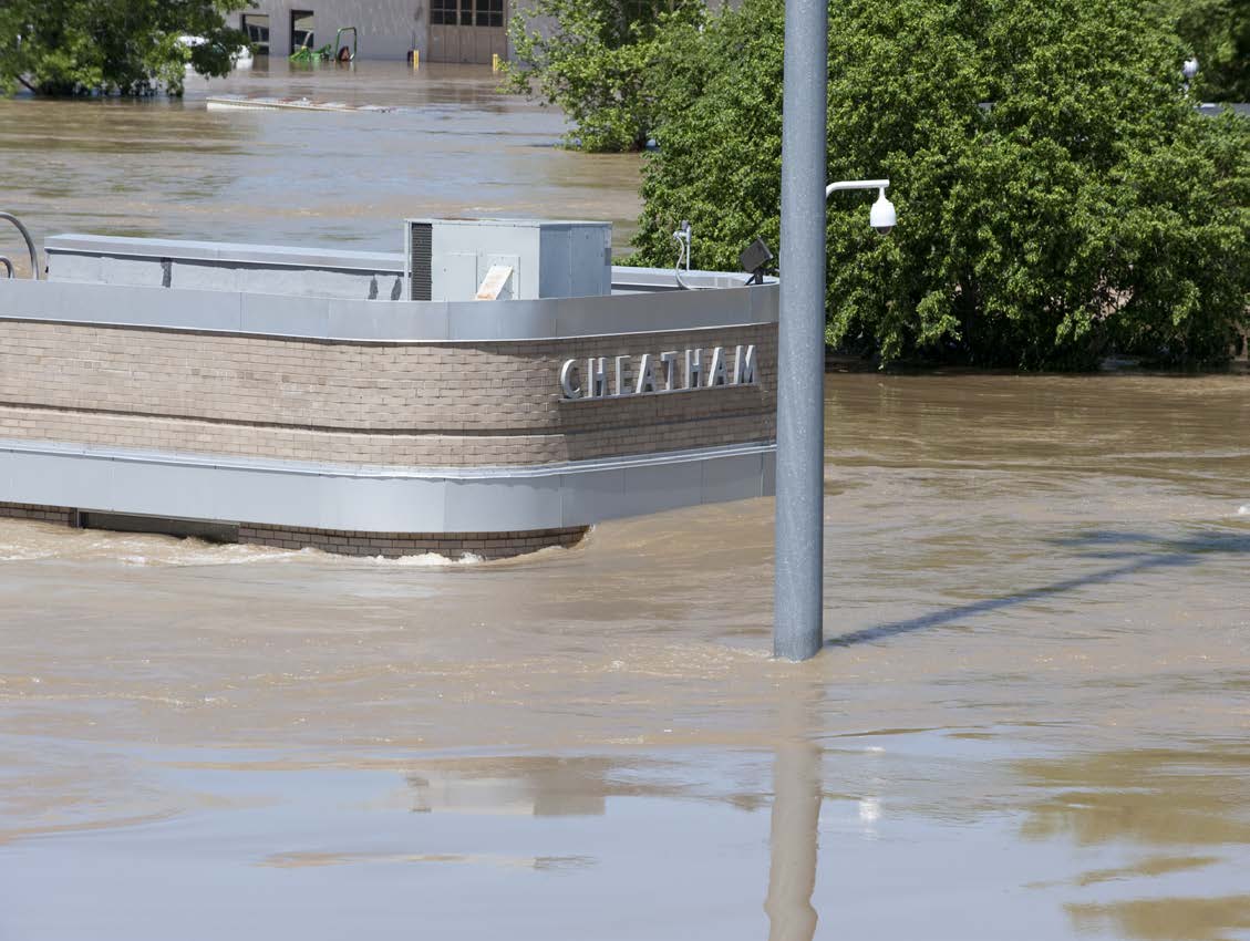
18 Cheatham Headwater Elevation Top of Lock Wall Top of Power Pool 18 18
19 19 19
20 Record Setting Flood Event Project Lake Elevation (ft) Previous May 2010 Record Project Discharge (cfs) Previous May 2010 Record Cordell Hull Lock & Dam (May 1984) 130, ,850 (March 1975) Old Hickory Lock & Dam (May 1984) 212, ,500 (March 1975) Cheatham Lock & Dam (March 1962) 240, ,670 (March 1962) Barkley Lock & Dam (May 1984) 303, ,980 (May 1983) 20

21 Post Flood Investigations Supplemental Appropriations Act of Post Flood Investigations Post Flood Documentation Report Update of Flood Profiles Flood Warning & Emergency Evacuation Planning Emergency Action Plans Cumberland River Recon Study Harpeth River Recon Study 21

22 Post Flood Investigations Supplemental Appropriations Act of 2010 Post Flood Documentation Report Collect high water marks Gather and evaluate detailed damage data Develop rainfall summary/curves Construct flood profiles on the Cumberland & 25 tributaries Gage/stage discharge summary for Cumberland & tributaries GIS inundation layers Develop flood damage modeling, flood impact assessments, on the Cumberland & 25 tributaries 22

23 Community Mapping Efforts Post May 2010 Local Streams 12 Basins 5 Counties May 2010 Event Profiles for 9 incremental rainfall events. Incremental Rainfall 3in 4in 5in 6in 7in 8in 9in 10in 11in Action Level C D E F G H I J K 23
 410 405 400 395 390 385 380 375 370 Cumberland City Cumberland River Flood Profiles - Barkley Reservoir Clarksville Gage -")
24 Cumberland River Mapping Efforts Post May Cumberland River Flood Inundation Derived from May 2010 Event Calibration and NWS Action Levels Elevation (Feet) River Miles Elevation (Feet) Cumberland City Cumberland River Flood Profiles - Barkley Reservoir Clarksville Gage - Inundation Mapping Layers Palmyra Clarksville Gage Stage 63 ft Stage 55 ft Stage 50 ft Stage 46 ft Stage 40 ft TN-48 County Line Profiles generated using HEC-RAS unsteady flow model simulation. River Miles shown below were generated from hydraulic model and may not match published USGS river miles. "Gage 0" Datum: 330.9' Gage Reading Stage 63 ft Stage 60 ft Stage 57 ft Stage 55 ft Stage 53 ft Stage 50 ft Stage 48 ft Stage 46 ft Stage 43 ft Stage 41 ft Stage 40 ft Stage 38 ft 365 Stage 32 ft Stage 32 ft Stage 30 ft 360 Summer Pool Winter Pool Cumberland River Miles 24
25 Metro Nashville Flood Preparedness Began in August 2010 with many agencies working together to develop products & applications to provide Metro officials with timely information. Corps of Engineers Participation Update hydrology & hydraulic modeling Transfer Models to FEMA for county-wide FIS Update Inundation Mapping for 11 scenarios used as inputs for the Nashville Situational Awareness of Flood Events (SAFE) program Real Time Simulation Modeling 25

26 2011 MR&T Flood Event 26
27 Water Stored After February 24, 2011 Project Headwater (02/24/2011) Headwater Crest Water Stored (acre-feet) Wolf Creek ,992,000 Dale Hollow ,000 Center Hill ,000 J. Percy Priest ,000 Total 3,307, Wolf Creek and Center Hill Dams had been classified as DSAC 1 dams and were under pool restrictions to assure the stability of the dams. 2 This volume of water is roughly equivalent to 1.08 quadrillion gallons of water or if stacked on a football field it would be 2.5 million feet (474 miles) high. 27
 720 715 710 705 700 Barkley Lock & Dam 695 4/12 Cordell Hull Lock & Dam Cheatham Lock & Dam 4/22 5/2 5/12 5/22 6/1 Wolf Creek Dam Old Hickory Lock & Dam Operation Watershed - Dale Hollow Dam 664")
28 Operation Watershed 4/26/2011 5/4/2011 Rainfall & Project Operations Cumberland River Basin Operation Watershed - Wolf Creek Dam 730 Observed Without Reductions 725 Top of Hydropower Pool Elevation (ft) Barkley Lock & Dam 695 4/12 Cordell Hull Lock & Dam Cheatham Lock & Dam 4/22 5/2 5/12 5/22 6/1 Wolf Creek Dam Old Hickory Lock & Dam Operation Watershed - Dale Hollow Dam 664 Top of Flood Control Pool Observed Without Reductions 662 Storage conserved in Barkley and Kentucky 4.65 feet Elevation (ft) 660 Dale Hollow Dam Dale Hollow J. Percy Priest 0.65 Top of Hydropower Pool 650 4/12 4/22 5/2 5/12 5/22 6/1 Center Hill 0.95 Operation Watershed - Center Hill Dam Wolf Creek J. Percy Priest Dam Observed Without Reductions Top of Hydropower Pool Top of Flood Control Pool 504 Observed Without Reductions 502 Storage at Peak Elevation Elevation (ft) 500 Center Hill Dam 498 Elevation (ft) Operation Watershed - J. Percy Priest Dam / /22 5/2 5/12 5/22 6/1 492 Available 490 Peak Pie area scaled to storage capacity 488 4/12 4/22 5/2 5/12 5/22 6/ BUILDING STRONG

29 2012 Regional Drought 29


30 Mississippi River Navigation During extreme drought >40% of the flow at Memphis can originate from the Tennessee and Cumberland Rivers The Tennessee and Cumberland Basins are ~6% of the drainage area at Memphis 30
 19 September 2012 Flow of 146,000 cfs Tennessee and Cumberland provided 53,000 cfs (36%) Stage at")
31 Mississippi River at Memphis Historic Low Levels 1) (7/10/1988) 2) (9/19/2012) 3) (9/20/2000) 19 September 2012 Flow of 146,000 cfs Tennessee and Cumberland provided 53,000 cfs (36%) Stage at 93,000 cfs ~

32 Recent Water Management Initiatives Water Management Center Update Modeling Tools Spillway Gate Monitoring Systems RiverStatus Mobile Web-site Educational Videos LRN Web-site 32

33 Questions? Nashville District Homepage 33
Nashville District Update for Tennessee Tombigbee Waterway Opportunities Conference
 Nashville District Update for Tennessee Tombigbee Waterway Opportunities Conference Mike Wilson, P.E. Deputy District Engineer for Project Management Planning, Programs and Project Management Division
Nashville District Workload for Nashville SAME Professional Development Workshop
 Nashville District Workload for Nashville SAME Professional Development Workshop Thomas Cayce, PE Chief, Programs and Project Delivery Branch Nashville District 17 August 2011 US Army Corps of Engineers
LEAGUE NOTES ON APPROVED COMMUNITY WATER SUPPLY PLAN
 1 AUGUST 2011 LEAGUE NOTES ON APPROVED COMMUNITY WATER SUPPLY PLAN KEY ELEMENTS OF THE PLAN: 1. Replace the existing unsafe Ragged Mountain dam with a new dam and raise the reservoir pool level initially
Dam Risk Reduction Case Study. Background Nashville and Davidson County, Tennessee, the population hub of Middle
 Dam Risk Reduction Case Study [NASHVILLE, TENNESSEE MAY 2010 FLOODING] Background Nashville and Davidson County, Tennessee, the population hub of Middle Tennessee with a combined population of over 635,000,
TENNESSEE GAS PIPELINE COMPANY, L.L.C.
 TENNESSEE GAS PIPELINE COMPANY, L.L.C. HYDROLOGIC & HYDRAULIC CALCULATIONS FOR WATERBODIES CROSSED BY CONNECTICUT PIPELINE EXPANSION PROJECT CONNECTICUT LOOP Submitted by: Tennessee Gas Pipeline Company,
The Mississippi River & Tributaries Project
 The Mississippi River & Tributaries Project The Mississippi River & Tributaries (MR&T) project was authorized by the 1928 Flood Control Act. Following the devastating 1927 flood, the nation was galvanized
U.S. Army Corps of Engineers Tulsa District
 U.S. Army Corps of Engineers Tulsa District Mike Abate, PMP. Chief, Civil Works Branch, PPMD April 17, 2015 US Army Corps of Engineers Civil Works Mission Water Supply 50% of Corps water supply contracts
NASHVILLE DISTRICT JETS SAME
 NASHVILLE DISTRICT JETS SAME Regional Program Review Savannah, GA 26 June 2014 US Army Corps of Engineers Agenda District Boundaries Cumberland & TN River Systems Major Construction Projects Hydropower/Navigation
Development of Technical Data For Long Term Flood Solutions For the Red River Basin
 IDENTIFYING WHAT WE DIDN T KNOW Development of Technical Data For Long Term Flood Solutions For the Red River Basin LTFS Study Area U.S. Portion of Red River Basin (MN, ND & SD) Main Stem Red River Tributaries
A Flood Warning System for City of Findlay, Ohio
 A Flood Warning System for City of Findlay, Ohio Matt Whitehead US Geological Survey, Ohio Water Science Center 6480 Doubletree Avenue Columbus, Ohio 43229 Abstract The U.S. Geological Survey (USGS) and
Thin Air and Thick Ice Unusual Challenges at a High Elevation Hydro Plant
 Thin Air and Thick Ice Unusual Challenges at a High Elevation Hydro Plant By Ginger Gillin, John Pizzimenti, and Doug Foss, GEI Consultants, Inc., USA, and Jon Jourdonnais, PPL Montana, USA. Abstract The
Recreational Enhancements on the Lehigh River Public Information Workshop February 2013
 Recreational Enhancements on the Lehigh River Public Information Workshop February 2013 Cooperating Agencies US Army Corps of Engineers Philadelphia District Pennsylvania Fish & Boat Commission Pennsylvania
DamWatch A WEB-BASED SOFTWARE SYSTEM TO MONITOR WATERSHED DAMS IN OKLAHOMA
 DamWatch A WEB-BASED SOFTWARE SYSTEM TO MONITOR WATERSHED DAMS IN OKLAHOMA Authors: Larry W. Caldwell, P.E., Oklahoma Conservation Commission, Stillwater, OK Joe Scannell, President,, USEngineering Solutions
Hydrologic Engineering Techniques for Regional Water Resources Planning
 US Army Corps of Engineers Hydrologic Engineering Center Hydrologic Engineering Techniques for Regional Water Resources Planning October 1969 Approved for Public Release. Distribution Unlimited. TP-17
US Army Corps of Engineers BUILDING STRONG
 Fort Worth District Public Meeting 20 August 2013 US Army Corps of Engineers Lewisville Dam - Authorization Authorized by the River and Harbor Act, approved 2 March 1945 (Public Law 14, 79th Congress,
Lockport Pool Chicago Sanitary & Ship Canal Illinois Waterway
 Presentation to the Inland Waterways Users Board Lockport Pool Chicago Sanitary & Ship Canal Illinois Waterway by Gary Loss, P.E. Rock Island District July 13, 2006 Chicago Sanitary and Ship Canal A
The City of Ottawa Flood Hazards
 The City of Ottawa Flood Hazards The City of Ottawa is located in North Central LaSalle County, approximately 45 miles West of Joliet and 90 miles South of Rockford. The primary water course and sources
Methods for Determination of Safe Yield and Compensation Water from Storage Reservoirs
 US Army Corps of Engineers Hydrologic Engineering Center Methods for Determination of Safe Yield and Compensation Water from Storage Reservoirs October 1966 Approved for Public Release. Distribution Unlimited.
The Mississippi River & Tributaries Project
 Following the Great Mississippi River Flood of 1927, the nation galvanized in its support for a comprehensive and unified system of public works within the lower Mississippi Valley that would provide enhanced
59742 Federal Register / Vol. 80, No. 191 / Friday, October 2, 2015 / Notices
 59742 Federal Register / Vol. 80, No. 191 / Friday, October 2, 2015 / Notices 408 mgd from the Chattahoochee River for Metro Atlanta and would reallocate storage in Lake Lanier of 189,497 acrefeet to satisfy
Reservoir Simulations for the Delaware River Basin Flood of June, 2006
 Reservoir Simulations for the Delaware River Basin Flood of June, 2006 Middle Atlantic River Forecast Center State College, PA August 2007 (Revised 9/13/07) Introduction: In the late spring of 2005, the
Record Floods of Greater Nashville: Including Flooding in Middle Tennessee and Western Kentucky, May 1-4, 2010
 Service Assessment Record Floods of Greater Nashville: Including Flooding in Middle Tennessee and Western Kentucky, May 1-4, 2010 U.S. DEPARTMENT OF COMMERCE National Oceanic and Atmospheric Administration
AZ EGER-PATAK HIDROLÓGIAI VIZSGÁLATA, A FELSZÍNI VÍZKÉSZLETEK VÁRHATÓ VÁLTOZÁSÁBÓL ADÓDÓ MÓDOSULÁSOK AZ ÉGHAJLATVÁLTOZÁS HATÁSÁRA
 AZ EGER-PATAK HIDROLÓGIAI VIZSGÁLATA, A FELSZÍNI VÍZKÉSZLETEK VÁRHATÓ VÁLTOZÁSÁBÓL ADÓDÓ MÓDOSULÁSOK AZ ÉGHAJLATVÁLTOZÁS HATÁSÁRA GÁBOR KEVE 1, GÉZA HAJNAL 2, KATALIN BENE 3, PÉTER TORMA 4 EXTRAPOLATING
HEADWATERS CONTROL STRUCTURE MANAGEMENT POLICY AND OPERATING PROCEDURES
 HEADWATERS CONTROL STRUCTURE MANAGEMENT POLICY AND OPERATING PROCEDURES INTRODUCTION The Headwaters Control Structure at Gray's Bay is the outlet of Lake Minnetonka to Minnehaha Creek. It is an adjustable
Stormwater Management in Chicago waterways :Basement Flooding and its prevention Kyungmin Kim
 Stormwater Management in Chicago waterways :Basement Flooding and its prevention Kyungmin Kim CE 394K GIS in Water Resources - David R. Maidment. Dec 4th 2015 Motivation and Objective Recently, Chicago
HCP Team Meeting. November 18, 2015. icfi.com
 HCP Team Meeting November 18, 2015 icfi.com 1 Welcome and Introductions Where are we in the HCP process Hydrology modeling update Native fish survey Fish translocation Finalize covered activities Next
Next Generation Flood Alert in Houston
 Next Generation Flood Alert in Houston Philip B. Bedient Civil and Environmental Eng., Rice University Houston, TX Major Causes of Urban Flooding (Excess Water that Inundates) Highly Developed (urbanized)
9.1. Adequacy of Available Data and Monitoring Efforts
 9. DATA MANAGEMENT Data management is a crucial aspect of successful implementation of the ARB IRWMP and its component projects. This section discusses the adequacy of available data and monitoring efforts,
PERFORMANCE OF DAMS AND SPILLWAYS 2009 GEORGIA FLOOD. Randall P. Bass, P.E. 1, 2. James R. Crowder, P. Joseph S. Monroe, P.E.
 PERFORMANCE OF DAMS AND SPILLWAYS 2009 GEORGIA FLOOD Randall P. Bass, P.E. 1, 2 James R. Crowder, P. Joseph S. Monroe, P.E. 3 ABSTRACT During the latter part of September 2009, the Atlanta metro area received
Comparative Evaluation of Generalized River/Reservoir System Models. by Ralph A. Wurbs Civil Engineering Department Texas A&M University
 Comparative Evaluation of Generalized River/Reservoir System Models by Ralph A. Wurbs Civil Engineering Department Texas A&M University TR-282 Texas Water Resources Institute College Station, Texas April
Section 19. Basin-wide Mitigation Action Plans
 Section 19. Basin-wide Mitigation Action Plans This Mitigation Plan identifies twelve specific hazards that could affect the Basin. Section 20 of this Plan set forth mitigation action plans to be carried
DISTRICT VALUES STATEMENTS, GOALS, ACTION ITEMS, AND ONGOING TASKS FOR 2015 Adopted by the Board of Directors December 10, 2014. Values Statements.
 DISTRICT VALUES STATEMENTS, GOALS, ACTION ITEMS, AND ONGOING TASKS FOR 2015 Adopted by the Board of Directors December 10, 2014 Values Statements. The Board opposes any new transfers of water from the
United States Army Corps of Engineers, Civil Works
 United States Army Corps of Engineers, Civil Works Fiscal Year 2013 Federal Program Inventory May 2013 Table of Contents Introduction... 2 Program Inventory... 3 1. Navigation... 3 2. Flood Risk Management...
Quantifying Potential Floodplain Restoration Benefits in the Upper Mississippi River Basin, USA
 Quantifying Potential Floodplain Restoration Benefits in the Upper Mississippi River Basin, USA Michael Schwar, Ph.D. PE (MARS) Eileen Fretz (American Rivers) Mississippi River Commission/USACE Upper Mississippi
PRECIPITATION AND EVAPORATION
 PRECIPITATION AND EVAPORATION OBJECTIVES Use historical data to analyze relationships between precipitation, evaporation and stream flow in the San Antonio River Basin TOPICS Water cycle Precipitation
Flood Guide lcra.org
 COLORADO RIVER Flood Guide lcra.org Be prepared for weather and flood emergencies If you live along the Highland Lakes, the lower Colorado River or its tributaries, it s critically important to be prepared
Swannanoa River Flood Risk Management Study
 Swannanoa River Flood Risk Management Study Measures Evaluated to Reduce Future Flood Damages City of Asheville U.S. Army Corps of Engineers Flooding History Part of the 132 square mile Swannanoa River
DANIELS RUN STREAM RESTORATION, FAIRFAX, VIRGINIA: FLOODPLAIN ANALYSIS REPORT
 DANIELS RUN STREAM RESTORATION, FAIRFAX, VIRGINIA: FLOODPLAIN ANALYSIS REPORT By: Conor C. Shea Stream Habitat Assessment and Restoration Program U.S. Fish and Wildlife Service CBFO-S07-01 Prepared in
How To Prepare For A Flood In Hampshire
 Chapter 6. Emergency Services Emergency services measures protect people during and after a flood. Locally, these measures are coordinated by the Huntsville-Madison County Emergency Management Agency.
Post-Flood Assessment
 Page 1 of 7 Post-Flood Assessment CHAPTER 4 AGENCY COORDINATION Agency coordination is an essential element for the operation of the flood management systems in the Central Valley. Due to the nature of
HYDROLOGIC/HYDRAULIC MODELING OF WESTMINSTER WATERSHED ORANGE COUNTY, CALIFORNIA
 HYDROLOGIC/HYDRAULIC MODELING OF WESTMINSTER WATERSHED ORANGE COUNTY, CALIFORNIA James Chieh, Ph.D., P.E., Senior Hydraulic Engineer, USACE, Los Angeles, California, Shih.H.Chieh@usace.army.mil; Jay Pak,
Stream Channel Cross Sections for a Reach of the Boise River in Ada County, Idaho
 U.S. Department of the Interior U.S. Geological Survey In cooperation with Federal Emergency Management Agency, City of Boise, City of Garden City, City of Eagle, and Ada County Stream Channel Cross Sections
April 17, 2015 SUMMARY OF SUBJECT MATTER
 April 17, 2015 SUMMARY OF SUBJECT MATTER TO: FROM: RE: Members, Subcommittee on Water Resources and Environment Staff, Subcommittee on Water Resources and Environment Hearing on A Review of the President
The Basics of Chapter 105 Waterways and Wetlands Permitting in PA
 The Basics of Chapter 105 Waterways and Wetlands Permitting in PA April 17, 2013 Goal To develop a basic understanding of PA Department of Environmental Protection (DEP) and US Army Corps of Engineers
CHECKLIST FOR FILING AN APPLICATION FOR A GROUND AND/OR SURFACE WATER WITHDRAWAL PROJECT IN THE DELAWARE RIVER BASIN
 CHECKLIST FOR FILING AN APPLICATION FOR A GROUND AND/OR SURFACE WATER WITHDRAWAL PROJECT IN THE DELAWARE RIVER BASIN PLEASE COMPLETE CHECKLIST AND ENCLOSE WITH THE APPLICATION. If you need assistance,
Lower Raritan Watershed Management Area Stormwater & Flooding Subcommittee Strategy Worksheet LRSW-S3C1
 Strategy Name: Reduce Existing Potential for Flood Damages LRSW-S3C1. Develop and implement a program to: Minimize flood damages through the use of structural measures. Minimize flood damages through the
US Army Corps of Engineers. New Orleans District 2011 Flood Response
 US Army Corps of Engineers New Orleans District 2011 Flood Response US Army Corps of Engineers BUILDING STRONG BUILDING STRONG 2011 Flood Fight The safety of the public is the Corps number one priority.
CRS 610 Ventura County Flood Warning System Website
 CRS 610 Ventura County Flood Warning System Website Purpose This document gives instructions and a description of the information available via the Ventura County Watershed Protection District s (VCWPD)
NWS Flood Inundation Mapping Program
 NWS Flood Inundation Mapping Program Carson River Floodplain Management Forum April 22, 2015 Mark Faucette, Senior Forecaster Hydrology Program Manager NOAA/NWS, WFO Reno, NV NWS Hydrologic Services Program
5.14 Floodplains and Drainage/Hydrology
 I-70 East Final EIS 5.14 Floodplains and Drainage/Hydrology 5.14 Floodplains and Drainage/Hydrology This section discusses floodplain and drainage/hydrology resources and explains why they are important
Burnt River Black River and Gull River Flood Contingency Plan
 Burnt River Black River and Gull River Flood Contingency Plan Objective: The objective of this plan is to preplan and prepare for flooding events in the Burnt River, Black River and Gull River area of
Flood mitigation program for Gatun lake. Programa de mitigación de inundaciones del lago Gatún
 Flood mitigation program for Gatun lake Programa de mitigación de inundaciones del lago Gatún Moffatt & Nichol Engineers 10 de febrero de 2005 Contrato No. 126161 Introducción y Recomendaciones 1 INTRODUCTION
Hydropower. Corps Hydro Plants Non-Federal Plants
 Hydropower Corps Hydro Plants Non-Federal Plants at Corps Dams The U.S. Army Corps of Engineers is the largest owner/operator of hydroelectric powerplants in the United States and one of the largest in
USGS StreamStats Web Application for Kentucky
 USGS StreamStats Web Application for Kentucky Implementation of selected low- and mean-flow estimating equations Gary Martin, Hydrologist Project Chief U.S. Geological Survey, Kentucky Water Science Center
The AIR Inland Flood Model for the United States In Spring 2011, heavy rainfall and snowmelt produced massive flooding along the Mississippi River,
 The AIR Inland Flood Model for the United States In Spring 2011, heavy rainfall and snowmelt produced massive flooding along the Mississippi River, inundating huge swaths of land across seven states. As
Water Resources Collections and Archives University of California
 Water Resources Collections and Archives University of California Title: Effects of climate change on the hydrology of upper Alameda Creek Author: Klausmeyer, Kirk, University of California, Berkeley Publication
Roosevelt Water Conservation District ROOSEVELT WATER CONSERVATION DISTRICT
 ROOSEVELT WATER CONSERVATION DISTRICT RESPONSE TO ARIZONA POWER AUTHORITY REQUEST FOR INFORMATION DATED SEPTEMBER 12, 2012 PRESENTED OCTOBER 24, 2012 RWCD is an irrigation district that was established
GRADY COUNTY, GEORGIA AND INCORPORATED AREAS
 GRADY COUNTY, GEORGIA AND INCORPORATED AREAS Community Name Community Number CAIRO, CITY OF 130097 GRADY COUNTY (UNINCORPORATED AREAS) 130096 WHIGHAM, CITY OF 130674 Grady County EFFECTIVE: August 18,
Indiana Office of Community and Rural Affairs. Disaster Recovery and Mitigation Planning Ft. Worth, Texas February 15, 2012
 Indiana Office of Community and Rural Affairs Disaster Recovery and Mitigation Planning Ft. Worth, Texas February 15, 2012 Floods Indiana s costliest hazard State ranks 5 th in annual median flood damages
Recent Innovations In Virginia Dam Safety & Floodplain Management Program
 Recent Innovations In Virginia Dam Safety & Floodplain Management Program Robert T. Bennett, P.E., R.A., C.F.M. Director Dam Safety & Floodplain Management Virginia Department of Conservation & Recreation
2013 Annual Climate Summary for the Southeast United States
 Months of heavy rain forced the U.S. Army Corp of Engineers to open the spillways at Lake Hartwell, located at the headwaters of the Savannah River along the South Carolina-Georgia border, on July 9,.
11 Flooding 11.1 HISTORICAL FLOODS
 11 Flooding Flood hazards in Humboldt County are attributable to rivers, dam failure, and coastal high water hazards (tsunamis and flood tides), with river flooding being by far the most prevalent. Flooding
BENEFITS OF USGS STREAMGAGING PROGRAM
 BENEFITS OF USGS STREAMGAGING PROGRAM USERS AND USES OF USGS STREAMFLOW DATA March 7, 2006 National Hydrologic Warning Council National Oceanic and Atmospheric Administration Cover - Grand Coulee Dam -
Hydrologic Aspects of Flood Warning Preparedness Programs
 US Army Corps of Engineers Hydrologic Engineering Center Hydrologic Aspects of Flood Warning Preparedness Programs August 1990 Approved for Public Release. Distribution Unlimited. TP-131 REPORT DOCUMENTATION
National Dam Safety Program Technical Seminar #22. When is Flood Inundation Mapping Not Applicable for Forecasting
 National Dam Safety Program Technical Seminar #22 Thursday February 19 th 2015 Emmittsburg, MD When is Flood Inundation Mapping Not Applicable for Forecasting Victor Hom Hydrologic Services Division National
Long Term Flood Solutions
 Long Term Flood Solutions Things we can do: Structural and Non-Structural Options 28th Annual Red River Basin Land & Water International Summit Conference January 18, 2011, Fargo, ND John Jaschke, Executive
Norfolk Flooding Strategy Update. Presentation to Norfolk City Council March 27, 2012
 Norfolk Flooding Strategy Update Presentation to Norfolk City Council March 27, 2012 Presentation Overview The purpose of this presentation is to provide City Council an update on activities carried out
Flooding in the Middle Koyukuk River Basin, Alaska August 1994
 Flooding in the Middle Koyukuk River Basin, Alaska August 1994 By David F. Meyer U.S. GEOLOGICAL SURVEY Water-Resources Investigations Report 95-4118 Prepared in cooperation with the FEDERAL EMERGENCY
URBAN DRAINAGE CRITERIA
 URBAN DRAINAGE CRITERIA I. Introduction This division contains guidelines for drainage system design and establishes a policy for recognized and established engineering design of storm drain facilities
This paper provides a concise description of
 13 UNIVERSITIES COUNCIL ON WATER RESOURCES ISSUE 130, PAGES 13-19, MARCH 2005 Overview of Flood Damages Prevented by U.S. Army Corps of Engineers Flood Control Reduction Programs and Activities James J.
Estimating Potential Reduction Flood Benefits of Restored Wetlands
 Estimating Potential Reduction Flood Benefits of Restored Wetlands Kenneth W. Potter University of Wisconsin Introduction Throughout the summer of 1993 a recurring question was the impact of wetland drainage
WATER QUALITY MODELING TO SUPPORT THE ROUGE RIVER RESTORATION
 WATER QUALITY MODELING TO SUPPORT THE ROUGE RIVER RESTORATION Edward H. Kluitenberg, P.E., Applied Science, Inc. Gary W. Mercer, P.E., Camp, Dresser and McKee Vyto Kaunelis, Wayne County Department of
Managing Our Water Retention Systems
 Managing Our Water Retention Systems 29th Annual USSD Conference Nashville, Tennessee, April 20-24, 2009 Hosted by Corps of Engineers On the Cover Wolf Creek Dam is on the Cumberland River in South Central
How to Become a Navy Engineer For $78,000 in USD
 Presentation to Associated General Contractors COL Mark Deschenes Commander US Army Corps of Engineers Rock Island District February 2014 US Army Corps of Engineers Rock Island District 78,000 Square Miles
LR 314 Working Group 5 Final Report
 LR 314 Working Group 5 Final Report I. Nebraska Department of Natural Resources Table 1. NDNR and NATURAL RESOURCES COMMISSION WATER/INTEGRATED MANAGEMENT PLANNING RELATED RESEARCH, STUDIES AND RELATED
GIS in Wastewater Collection System Master Planning
 Page 1 of 6 GIS in Wastewater Collection System Master Planning Brad Roeth, EIT Stanley Consultants, Inc. This paper presents the use of GIS in a wastewater collection system master plan. The master plan
Hydrologic Modeling using HEC-HMS
 Hydrologic Modeling using HEC-HMS Prepared by Venkatesh Merwade School of Civil Engineering, Purdue University vmerwade@purdue.edu April 2012 Introduction The intent of this exercise is to introduce you
Des Moines River Regulated Flow Frequency Study
 E S I Des Moines River Regulated Flow Frequency Study MINNESOTA WISCONSIN D E S C E D A R M I S S I M O I N S S I P P R A C C O O N R I V E R Saylorville Lake Des Moines - SE 6th St #* Lake Red Rock I
USACE Dam Safety Program Current Approach & Methodology
 USACE Dam Safety Program Current Approach & Methodology Siamac Vaghar, PE, MASCE Chief, Geotechnical Engineering Section Dam Safety Program Manager US Army Corps of Engineers New England District Corps
SIMPLIFIED INUNDATION MAPS FOR EMERGENCY ACTION PLANS. National Dam Safety Review Board Emergency Action Plan Workgroup
 SIMPLIFIED INUNDATION MAPS FOR EMERGENCY ACTION PLANS National Dam Safety Review Board Emergency Action Plan Workgroup EXECUTIVE SUMMARY Development of Emergency Action Plans (EAPs) for all high and significant
Flood Insurance Guide THE INSURANCE AGENT S ROLE IN PROTECTING HOMEOWNERS
 Flood Insurance Guide THE INSURANCE AGENT S ROLE IN PROTECTING HOMEOWNERS Table of Contents Introduction... 3 Your Clients Need Flood Insurance... 5 For Most of the U.S., Flood Insurance Is Highly Affordable...
Flood Plain Reclamation to Enhance Resiliency Conserving Land in Urban New Jersey
 Flood Plain Reclamation to Enhance Resiliency Conserving Land in Urban New Jersey Rutgers Cooperative Extension Water Resources Program Christopher C. Obropta, Ph.D., P.E. Email: obropta@envsci.rutgers.edu
Shooks Run Drainage Study Basic Terminology
 Shooks Run Drainage Study Basic Terminology PREPARED FOR: PREPARED BY: City of Colorado Springs CH2M DATE: April 9, 2015 Introduction This document is intended to provide an introduction to Colorado Springs
Aligning Natural and Built Infrastructure for
 Aligning Natural and Built Infrastructure for Houston Climate Resilience National Exercise Program (NEP) Houston Climate Change Preparedness & Resilience Workshop Edmond J. Russo, Jr., PhD, PE, D.CE, D.NE,
Chehalis River Basin Flood Damage Reduction 2013-2015 Capital Budget Approved by Legislature in June 2013
 Chehalis River Basin Flood Damage Reduction 2013-2015 Capital Budget Approved by Legislature in June 2013 1. Design alternatives for large capital flood projects (basinlevel water retention and Interstate
CHICKASAW COUNTY, MISSISSIPPI, AND INCORPORATED AREAS
 CHICKASAW COUNTY, MISSISSIPPI, AND INCORPORATED AREAS Chickasaw County Community Name Community Number CHICKASAW COUNTY 280269 (UNINCORPORATED AREAS) HOUSTON, CITY OF 280030 NEW HOULKA, TOWN OF 280067
An Environmental Public Health Response to a Major High Water Event
 An Environmental Public Health Response to a Major High Water Event Tyler Zerwekh, DrPH, REHS Administrator Environmental Health Services Bureau Shelby County Health Department Presentation Objectives
Oklahoma Governor s Water Conference
 Oklahoma Governor s Water Conference COL Michael Teague District Commander Tulsa District US Army Corps of Engineers 27 October 2010 US Army Corps of Engineers Tulsa District Over 600 people Arkansas River
7 th Annual Technical Conference Georgia Association of Floodplain Management. Legacy Lodge @ Lake Lanier Islands Resort LESSONS LEARNED
 7 th Annual Technical Conference Georgia Association of Floodplain Management Legacy Lodge @ Lake Lanier Islands Resort LESSONS LEARNED The Flood of September 21, 2009 in Cobb County Georgia March 28,
USACE Civil Works Infrastructure Investment Trends: Glide-Path to Benign Neglect?
 USACE Civil Works Infrastructure Investment Trends: Glide-Path to Benign Neglect? National Waterways Conference Legislative Summit Steven L. Stockton, P.E. Director of Civil Works, U.S. Army Corps of Engineers
Fort Dodge Stormwater Master Planning. Prepared By: Ralph C. Stark, Jr., P.E., C.F.M. Joel N. Krause, P.E., C.F.M.
 Fort Dodge Stormwater Master Planning Prepared By: Ralph C. Stark, Jr., P.E., C.F.M. Joel N. Krause, P.E., C.F.M. Project Location Project Background Flooding History Localized flooding and storm sewer
ROLE OF THE MODELING, MAPPING, AND CONSEQUENCES PRODUCTION CENTER
 ROLE OF THE MODELING, MAPPING, AND CONSEQUENCES PRODUCTION CENTER Russ Wyckoff, P.E., CFM, MMC Modeling Lead, Tulsa District, USACE, Tulsa, Oklahoma, russell.wyckoff@usace.army.mil ABSTRACT: The goal of
State-Federal Flood Operations Center Informational Sheet
 State of California The Resources Agency DEPARTMENT OF WATER RESOURCES DIVISION OF FLOOD MANAGEMENT State-Federal Flood Operations Center Informational Sheet November 2014 Flood Operations Branch Overview
Final Report. Dixie Creek Restoration Project. Funded by Plumas Watershed Forum
 Final Report Dixie Creek Restoration Project Funded by Plumas Watershed Forum Plumas Corporation January 2009 1 Background FR-CRM staff presented this project to the Dixie Valley Landowners Association
Section 2. Mono Basin Operations
 Section 2 Mono Basin Chapter 2 Mono Basin Compliance with State Water Resources Control Board Decision 1631 and Order Nos. 98-05 and 98-07 May 2008 Los Angeles Department of Water and Power Table of Contents
Environmental Data Management Programs
 Hydrologic Engineering Centre (HEC) Software CD Collection of programs, developed by the U.S. Army Corps of Engineers Environmental Data Management Programs Name: HEC-DSS Package Purpose: Data Storage
An Analysis on Managed Flood Storage Options for Selected Levees along the Lower Illinois River for Enhancing Flood Protection
 Contract Report 645 An Analysis on Managed Flood Storage Options for Selected Levees along the Lower Illinois River for Enhancing Flood Protection Report No. 4: Flood Storage Reservoirs and Flooding on
Prattsville Berm Removal Project. 1.0 Project Location
 Prattsville Berm Removal Project 1.0 Project Location The project site is located between the New York State Route 23 Bridge over the Schoharie Creek and the Schoharie Reservoir. The restoration plan encompassed
Wolf Creek Hydropower Rehabilitation Analysis Report
 Wolf Creek Hydropower Rehabilitation Analysis Report David Bishop Kris Atanassov Team Cumberland, September 16, 2015 US Army Corps of Engineers Agenda Overview Water Availability Energy Modeling Preliminary
ROSE CREEK WATERSHED HYDROLOGIC, HYDRAULIC, SEDIMENT TRANSPORT, AND GEOMORPHIC ANALYSES TASK 1 EXISTING DATA AND INFORMATION SUMMARY REPORT BACKGROUND
 ROSE CREEK WATERSHED HYDROLOGIC, HYDRAULIC, SEDIMENT TRANSPORT, AND GEOMORPHIC ANALYSES TASK 1 EXISTING DATA AND INFORMATION SUMMARY REPORT BACKGROUND The Rose Creek Watershed (RCW) consists of three planning