DEVELOPMENT PERMIT APPLICATION: S/F/ /9097 James Young Part Lot 10, Concession 7, Township of Clearview, Simcoe County
|
|
|
- Merilyn Harvey
- 7 years ago
- Views:
Transcription
 599-3340 Télécopieur (519) 599-6326 www.escarpment.")
1 Niagara Escarpment Commission 99 King Street East P.O. Box 308 Thornbury, ON N0H 2P0 Tel. No. (519) Fax No. (519) Commission de l escarpement du Niagara 99, rue King est p.o.b. 308 Thornbury ON N0H 2P0 No de tel. (519) Télécopieur (519) October 7, 2013 STAFF REPORT DEVELOPMENT PERMIT APPLICATION: S/F/ /9097 James Young Part Lot 10, Concession 7, Township of Clearview, Simcoe County PROPOSAL DESIGNATION LOT SIZE ISSUE RECOMMENDATION REASON REPORT SUMMARY To re-establish a former pond site and construct an island feature Escarpment Natural Area 11 ha (27.5 ac) Pond has reverted to a natural state; not a permitted use in Escarpment Natural Area; re-establishment of a pond will potentially result in environmental degradation downstream Refusal New/expansion/enlargement of a pond is not permitted in Escarpment Natural Area; NVCA does not support the reestablishment of the pond; not consistent with the PPS. RECEIVED: October 17, 2012 SOURCE: James Young applicant/owner PROPOSAL: To re-establish a recreational use spring-fed pond, approximately 90 m x 35 m x 4 m (295 ft x 115 ft x 13 ft deep), construct a small island near the west end, and deposit the excavated material on-site in the upper pasture west of the house, on a 11 ha (27.5 ac) existing lot. RELATED FILES: S/T/97-98/124 (Young) A Development Permit was issued to rehabilitate an existing bridge providing private access across the Noisy River to a residence on the subject property. 1 of 7 1
2 ANALYSIS: 1. NIAGARA ESCARPMENT PLAN: The property is designated Escarpment Natural Area and Escarpment Rural Area by the Niagara Escarpment Plan. The pond site is located within the more restrictive Escarpment Natural Area designation. A non-farm pond is not included as a permitted incidental use or accessory facility in the Escarpment Natural Area list of permitted uses. The application submitted describes the proposed work as a clean-out of an existing pond. Existing uses (i.e., non-conforming uses) are permitted under the Escarpment Natural Area designation, subject to satisfying the applicable Development Criteria. The boundaries of the former pond, however, are not evident. The former pond has reverted to a wetland feature. The construction activity required to re-establish a pond and create an island feature at this location is more extensive than a clean-out and in staff s opinion represents an expansion or new construction. The historic pond was a recreational use pond and does not meet the definition of farm pond (necessary to an active and viable farm operation, and no feasible water supply alternative exists). The Existing Uses Development Criteria (Section 2.3.6) states that, The expansion or enlargement of existing ponds is not permitted unless it is a farm pond and is not located in the Escarpment Natural Area. As the pond is located in the Escarpment Natural Area and does not meet the definition of a farm pond, no expansion or enlargement is permitted. Objective 1 of the Escarpment Natural Area is to maintain the most natural Escarpment features, stream valleys, wetlands and related significant natural areas and associated cultural heritage features. The historic man-made pond has reverted to a natural wetland feature which functions as a groundwater discharge area supplying good quality, cold-temperature water to the Noisy and Mad Rivers. The proposed reestablishment of a man-made pond is not in keeping with the objective to maintain the most natural Escarpment features. The Objective of the Water Resources Development Criteria (Sec. 2.6) is to ensure that new development affecting streams, watercourses, lakes, wetlands and groundwater systems will have minimum individual and cumulative effect on water quality and quantity, and on the Escarpment environment. Man-made ponds often have a negative environmental impact as the increased surface area allows warming of the pond water and receiving waters, is vulnerable to the introduction of non-native species of plants and fish, and by removing bulrushes, the function of nutrient uptake is lost. The Water Resources Development Criteria with regard to Ponds (Sec ) states that, Existing ponds shall be encouraged to revert to a natural state (e.g. where there 2 of 7 2
3 are significant environmental impacts or structural problems). The original pond has reverted to a more natural state as a wetland feature. Disturbance of the area in an attempt to re-establish a pond will potentially result in downstream water quality degradation. Section Ponds also addresses existing ponds, indicating Where an existing pond has a substantial ecological or potentially hazardous impact, the property owner shall be encouraged to take corrective measures which may include the installation of a bottom draw-off device or the establishment of a natural vegetative buffer at the edge of the pond. Section Ponds states that, Where possible, ponds should be designed to be off-stream with bottom-draw-off control structures. In this case, the historic pond is located in a source area that discharges to a coldwater stream. This location is therefore considered to be an on-stream pond. Natural vegetation has established itself, forming a stable wetland community with a channelized outflow to the river systems. GIS mapping identifies two unclassified wetland features on the property. The Water Resources Development Criteria regarding Wetlands (Sec ) requires that, Development shall locate outside wetlands. It is staff s opinion that the reestablishment of the pond in close proximity to these features would be contrary to this criteria and could result in short term impact from sediment migration and long term negative affect of raising water temperature in the receiving waters. The reestablishment of a pond may result in the degradation of the wetland discharge function. The General Development Criteria (Sec b) states that permitted uses may be allowed provided that, The cumulative impact of development will not have serious detrimental effects on the Escarpment environment (e.g. water quality, vegetation, soil, wildlife and landscape). To assess the potential cumulative impact of the proposed pond clean-out at this location, the characteristics and location of other ponds existing within this area was considered. There are two on-line ponds existing on a tributary of the Noisy River to the south of the subject property that outlet into the Noisy River on the subject property. The Nature Conservancy of Canada (NCC) submitted a Development Permit Application in 2007 (S/F/ /9015) to remove one of these on-stream ponds from the tributary of the Noisy River within the Creemore Nature Preserve property. The proposal was to redirect flow to the original stream channel and restore the pond area to a wetland community. The intent was to lower water temperature, improve water quality and enhance brook trout habitat. The proposed removal of a dam was intended to eliminate the potential for structural failure and resulting downstream siltation. This proposal was not acted upon and the Development Permit has expired. NCC is in the process of submitting a new application with the work proposed for the summer of of 7 3
4 2. COUNTY OFFICIAL PLAN: The County of Simcoe Official Plan designates the property as Escarpment Natural Area and Escarpment Rural Area. Within the Niagara Escarpment Plan Area, the policies of the NEP apply, as well as the County OP policies and the Township of Clearview Official Plan where they do not conflict with the NEP. The County OP also designates part of the property as Greenlands, a designation that is part of their Natural Heritage Systems planning. Section of the County OP states that, Surface and ground water resources in sufficient quality and quantity shall be maintained, and enhanced where possible, to meet existing and future needs on an environmentally sustainable basis. 3. LOCAL OFFICIAL PLAN: The lands are designated Escarpment Natural Area and Escarpment Rural Area in the Township of Clearview Official Plan. The objectives and permitted uses are as per the NEP. Greenland areas are delineated in this plan to identify natural heritage resource areas of significant ecological importance. PROVINCIAL POLICY STATEMENT: Section Water of the Provincial Policy Statement (PPS) states that: Development and site alteration shall be restricted in or near sensitive surface water features and sensitive groundwater features such that these features and their related hydrologic functions will be protected, improved or restored. This development proposal is not consistent with the Provincial Policy Statement. 4. CONSULTED AGENCIES: a) Township of Clearview Planning Dept - does not object to the proposed construction, providing the development permit, if allowed, be conditional on the applicant obtaining and/or meeting the following: 1. The applicant obtain a permit from the Nottawasaga Valley Conservation Authority, if required. b) Simcoe County Planning Dept - advises that the County defers to the Nottawasaga Valley Conservation Authority. c) Ministry of the Environment - did not provide comments. d) Nottawasaga Valley Conservation Authority (NVCA) - reviewed this application in concert with regulations established under the Conservation Authorities Act; advised that the subject property is under the regulatory jurisdiction of the NVCA due to the erosion and flood hazards associated with the Mad River Subwatershed, as well as 4 of 7 4
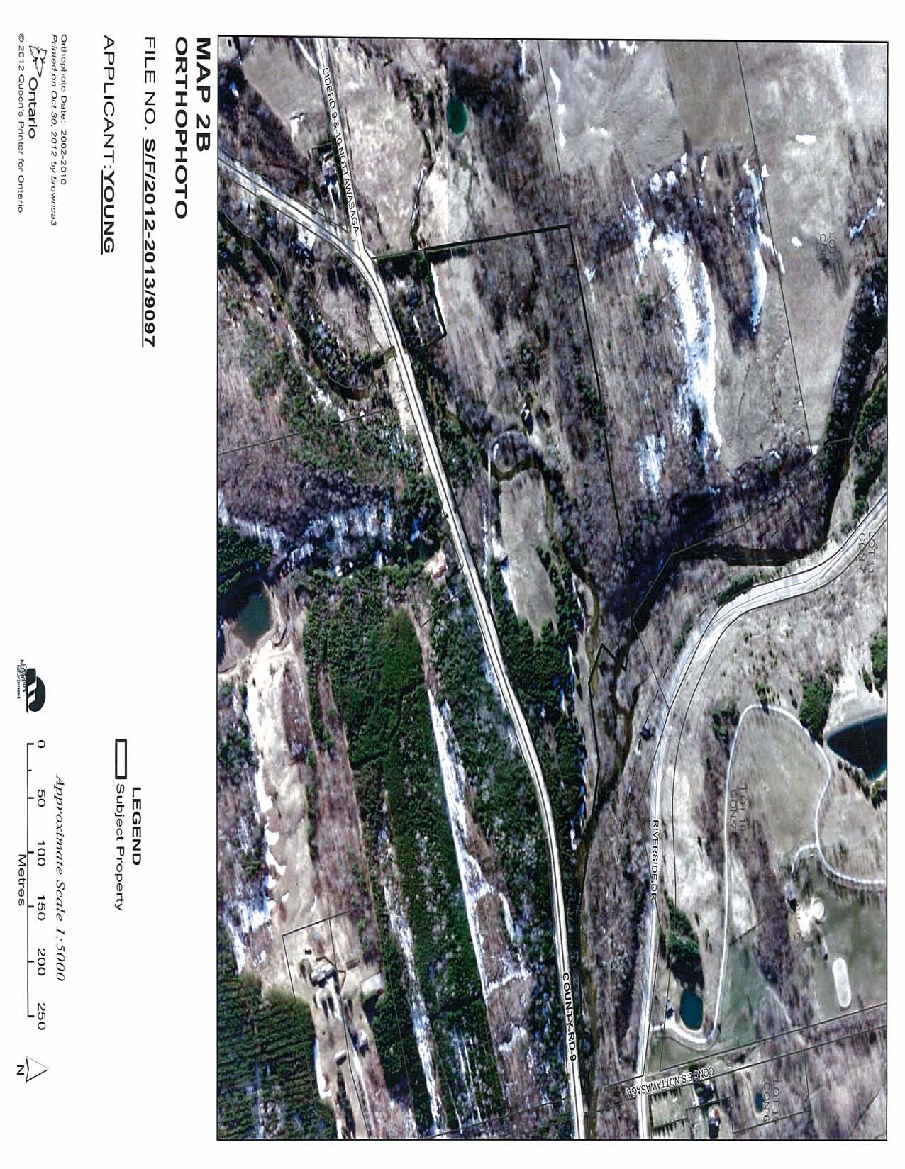
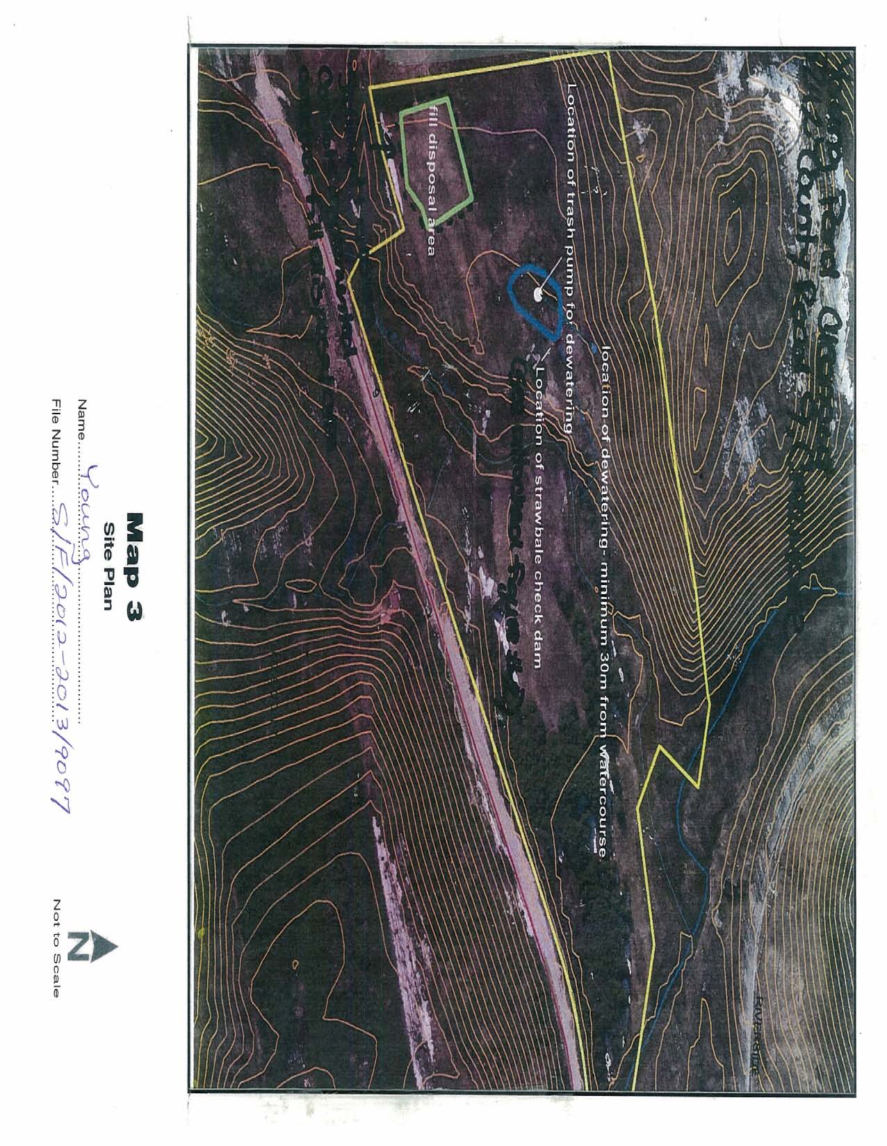
5 an unidentified wetland at the location of the pond. The NVCA initially had no objection to the approval of this application subject to the Niagara Escarpment Commission including the following condition in any approval: 1. That a permit be obtained from the Nottawasaga Valley Conservation Authority under the Conservation Authorities Act. PLEASE NOTE: Any submitted site plans must show that the size and depth of the pond has not increased from its original size and depth. The pond must not be expanded any further east than the existing outlet, to maintain the existing stream. All excavated material will have to be placed in a location not regulated by the Conservation Authority; However, upon further field review by NVCA ecology and planning staff, they amended their comments and concluded that the expansion of the pond footprint and the re-establishment of the pond will incur significant thermal impacts to the coldwater Mad River system; and, the NVCA will not support the re-establishment of a small pond in this location. 5. SITE ANALYSIS: The property is located west of Creemore near the confluence of the Noisy and Mad Rivers. The Noisy River flows diagonally through the property dividing it in two. The existing dwelling and historical pond is located on the western portion of the property approximately 50 m (164 ft) upstream of the river. The historic pond that once existed adjacent the house has grown in with bulrushes and has reverted to a wetland feature. At the time of the site visit, there was little open water and it was difficult to determine the original pond dimensions. The applicant provided photographs of the pond from the early 1950s that show an expanse of open water north of the house. The former pond area contains seeps that flow and outlets through a 20 cm (8 inch) diameter pipe forming a small tributary. The small tributary flows to the Noisy River which joins the Mad River, immediately east of the subject property. There is no evidence of a bottom draw outlet or control structure. According to the applicant the intent of the proposed clean-out is to restore the pond, attract wildlife, improve the water quality and provide a holding pond for fire suppression and possibly native fish habitat. Grading around the pond would not change. The lawn area is to remain on the south side and the balance of the area surrounding would remain natural. The excavated material would be deposited in a pasture field to the west, well away from the watercourse and levelled off. Sediment and erosion control would be carried out with a straw bale check dam in the spillway installed according to general example drawings supplied by NVCA. The applicant intends to increase the diversity of the plant life and will be relying on NVCA advice regarding plant species. NVCA staff described the historic pond footprint as a cattail marsh with a smaller area of herbaceous emergent marsh along the south side. The NVCA observed a clearly defined, flowing channel along the cattail/herbaceous marsh edge. West of the large 5 of 7 5
6 willow the wetland grades to a thicket swamp (willow) and opens into a mixed swamp with the groundcover dominated by wetland flora (cattails, sensitive fern and ostrich fern). Seepage areas were scattered throughout this area. The wetland is supported by a groundwater discharge area and likely contributes to coldwater habitat in the Mad River. COMMENT: As the historic boundary of the pond is not evident, the re-establishment of a pond at this location will require substantial construction as opposed to a minor maintenance clean-out. It is staff s opinion that the extent of this proposal represents an expansion/enlargement of the former pond. The NEP does not permit the expansion/enlargement of an existing non-farm pond within the Escarpment Natural Area. The Development Criteria of the NEP does not support the creation of new on-line ponds and encourages existing ponds to revert to a natural state. A pond is considered an on-line (on-stream) pond if it creates a permanent outflow that connects to a watercourse. The historic pond on this property is by definition an on-line pond as there is a permanent flow which outlets to the Noisy and Mad Rivers. On-line ponds, which affect both the surface water hydrology and sediment budget of a stream, have the greatest potential for negative impact on the water resources. This historic pond site has reverted to a natural state that currently supports a diverse wetland community. The groundwater discharge from the wetland contributes to the coldwater habitat in the Mad River. The proposed re-establishment of a pond at this location will potentially result in both short term and long term environmental degradation downstream. The proposed re-establishment of a recreational use on-line pond on the subject property connected to a nearby coldwater river system is not a permitted use under the NEP and is contrary to current environmental practice. RECOMMENDATION: The application should be refused for the following reasons: 1. The proposed re-establishment/expansion/enlargement of an historic pond site is not a permitted use within the Escarpment Natural Area designation of the Niagara Escarpment Plan (Sec. 1.3). 2. The proposed re-establishment/expansion/enlargement of an historic pond site does not satisfy the General Development Criteria (Sec. 2.2), the Existing Uses Development Criteria (Sec. 2.3), and the New Development Affecting Water Resources Development Criteria (Sec. 2.6) of the Niagara Escarpment Plan. 6 of 7 6
7

8
9
10
11

12
4. Environmental Impacts Assessment and Remediation Targets
 4. Environmental Impacts Assessment and Remediation Targets 4.1 Environmental Impacts Significant additional development in the Alder Creek watershed is not anticipated at this time; however, there are
Restoration Planning and Development of a Restoration Bank
 Restoration Planning and Development of a Restoration Bank Black Creek Pioneer Village, South Theatre 8:30 a.m. to 3:30 p.m. Habitat Restoration and Environmental Monitoring Projects Section Restoration
Gold Ray Dam Interagency Technical Team Meeting
 Gold Ray Dam Interagency Technical Team Meeting Agenda Public Outreach, Funding, Monitoring EA/BA/Permit Updates Deconstruction Plans Fish Passage & Salvage Plan Hydraulic Modeling Next Steps Public Outreach,
Ponds- Planning, Design, Construction
 United States Department of Agriculture Soil Conservation Service Agriculture Handbook Number 590 Ponds- Planning, Design, Construction This handbook describes the requirements for building a pond. It
March 2008. Prepared by: Irvine Ranch Water District. 15600 Sand Canyon Avenue. Irvine, CA 92618. Contact: Natalie Likens (949) 453-5633
 453-5633") ADDENDUM TO THE MICHELSON WATER RECLAMATION PLANT PHASE 2 & 3 CAPACITY EXPANSION PROJECT FEBRUARY 2006 FINAL ENVIRONMENTAL IMPACT REPORT AND THE SAN JOAQUIN FRESHWATER MARSH ENHANCEMENT PLAN REVISED SEPTEMBER
ADDENDUM TO THE MICHELSON WATER RECLAMATION PLANT PHASE 2 & 3 CAPACITY EXPANSION PROJECT FEBRUARY 2006 FINAL ENVIRONMENTAL IMPACT REPORT AND THE SAN JOAQUIN FRESHWATER MARSH ENHANCEMENT PLAN REVISED SEPTEMBER
Adopted 9/23/98 CHATTAHOOCHEE CORRIDOR PLAN. The goals of the Chattahoochee Corridor Plan (hereinafter also referred to as the Plan ) are:
 are:") CHATTAHOOCHEE CORRIDOR PLAN Adopted 9/23/98 PART 1: GOALS. POLICY. COVERAGE. A. Goals The goals of the Chattahoochee Corridor Plan (hereinafter also referred to as the Plan ) are: 1. Preservation and protection
CHATTAHOOCHEE CORRIDOR PLAN Adopted 9/23/98 PART 1: GOALS. POLICY. COVERAGE. A. Goals The goals of the Chattahoochee Corridor Plan (hereinafter also referred to as the Plan ) are: 1. Preservation and protection
BLACK/HARMONY/FAREWELL CREEK WATERSHED EXISTING CONDITIONS REPORT CHAPTER 12 - STORMWATER MANAGEMENT
 Harmony Creek subwatershed Harmony Creek subwatershed BLACK/HARMONY/FAREWELL CREEK WATERSHED EXISTING CONDITIONS REPORT CHAPTER 12 - STORMWATER MANAGEMENT April 2011 TABLE OF CONTENTS 1.0 INTRODUCTION...
How To Plan A Buffer Zone
 Backyard Buffers Protecting Habitat and Water Quality What is a buffer? A buffer (also called a riparian buffer area or zone) is the strip of natural vegetation along the bank of a stream, lake or other
Appendix A. Lists of Accomplishments and Project Costs. UMRWD 10 Year Plan Update. Appendix A UPPER MINNESOTA RIVER WATERSHED DISTRICT
 UPPER MINNESOTA RIVER WATERSHED DISTRICT Lists of Accomplishments and Project Costs 10 Year Plan Update UMRWD 10 Year Plan Update Page A 1 UMRWD LIST OF ACCOMPLISHMENTS Since its inception in 1967, the
COMPREHENSIVE PLAN SECTION B, ELEMENT 4 WATER RESOURCES. April 20, 2010 EXHIBIT 1
 COMPREHENSIVE PLAN SECTION B, ELEMENT 4 WATER RESOURCES April 20, 2010 EXHIBIT 1 ELEMENT 4 WATER RESOURCES TABLE OF CONTENTS 4.1 INTRODUCTION 4.2 GOALS AND POLICIES 4.2.A General Goals and Policies 1 4.2.B
GLOSSARY OF TERMS CHAPTER 11 WORD DEFINITION SOURCE. Leopold
 CHAPTER 11 GLOSSARY OF TERMS Active Channel The channel that contains the discharge Leopold where channel maintenance is most effective, sediment are actively transported and deposited, and that are capable
Rhode Island NRCS received approximately $2.4 million in ARRA funds to implement four floodplain easement projects.
 American Recovery and Reinvestment Act (ARRA) Emergency Watershed Protection Program Floodplain Easements Rhode Island Natural Resources Conservation Service Rhode Island NRCS received approximately $2.4
REFERENCE. All National Grid personnel who plan and perform work involving protected water resources are responsible for:
 EG-30NY ENVIRONMENTAL GUIDANCE PAGE 1 of 9 DATE 10/1/10 EP 3 Natural Resource Protection 1.0 SCOPE AND RESPONSIBILITIES National Grid s New York service territory encompasses thousands of wetlands, lakes,
The Basics of Chapter 105 Waterways and Wetlands Permitting in PA
 The Basics of Chapter 105 Waterways and Wetlands Permitting in PA April 17, 2013 Goal To develop a basic understanding of PA Department of Environmental Protection (DEP) and US Army Corps of Engineers
Background Information: The Mamquam River Floodplain Restoration Project
 Background Information: The Mamquam River Floodplain Restoration Project The Mamquam River Floodplain Restoration project is being undertaken in partnership with the Squamish River Watershed Society, Fisheries
CLACKAMAS COUNTY ZONING AND DEVELOPMENT ORDINANCE
 1008 STORM DRAINAGE (3/24/05) 1008.01 PURPOSE To minimize the amount of stormwater runoff resulting from development utilizing nonstructural controls where possible, maintain and improve water quality,
Michigan Wetlands. Department of Environmental Quality
 Department of Environmental Quality Wetlands are a significant component of Michigan s landscape, covering roughly 5.5 million acres, or 15 percent of the land area of the state. This represents about
3. The submittal shall include a proposed scope of work to confirm the provided project description;
 QIN Shoreline Master Program Project Summary The Shoreline Master Program (SMP) development process for the Quinault Indian Nation (QIN) includes the completion of inventory and analysis report with corresponding
Stream Rehabilitation Concepts, Guidelines and Examples. Objectives. Pierre Y. Julien. Three Laws of Stream Restoration
 Stream Rehabilitation Concepts, Guidelines and Examples Pierre Y. Julien Wuhan 2005 Objectives Part I - Stream restoration and rehabilitation: 1. Present and discuss important concepts, laws, criteria
PUBLIC NOTICE Application for Permit
 PUBLIC NOTICE Application for Permit 30-Day Notice Issue Date: June 20, 2016 Expiration Date: July 20, 2016 US Army Corps of Engineers No: NWP-2010-535 Oregon Department of State Lands No: 58311-RF Interested
Chapter 3 SENSITIVE AREAS AND VEGETATED CORRIDORS
 Chapter 3 3.01 General Provisions 3.01.1 Introduction 3.01.2 Application and Interpretation of Chapter 3.01.3 Unbuildable Lots 3.01.4 Other Permits 3.01.5 Prohibited Activities 3.02 Service Provider Letter
Addendum D. Nomination of Moody Wash ACEC
 Addendum D Nomination of Moody Wash ACEC Moody Wash ACEC is hereby nominated by Citizens for Dixie s Future to: BLM St. George Field Office 345 East Riverside Drive St. George, UT 84790 Moody Wash is a
Waterway Technote Drains
 Waterway Technote Drains Contents Benefits of good drain practice 1 Are your drains healthy? 2 The Sustainable Dairying Water Accord 3 Planning drain maintenance 3 Fencing and clearing 3 Bank shaping (battering)
GROWER ADVISORY Agriculture Regulations of the Wetlands Protection Act
 Cape Cod Cranberry Growers Association GROWER ADVISORY Agriculture Regulations of the Wetlands Protection Act Cranberry Bogs and the Agricultural Exemption The Massachusetts Wetlands Protection Act (WPA)
Land Disturbance, Erosion Control and Stormwater Management Checklist. Walworth County Land Conservation Department
 Land Disturbance, Erosion Control and Stormwater Management Checklist Walworth County Land Conservation Department The following checklist is designed to assist the applicant in complying with the Walworth
Community Workshop 5. Overarching Goals for Machado Lake Ecosystem and Wilmington Drain Multi-Use Projects
 City of Los Angeles Department of Public Works Bureau of Engineering Machado Lake Ecosystem Rehabilitation Project & Wilmington Drain Multi-Use Project Community Workshop 5 February 24, 2009 In association
What Is Rehabilitation?
 Location of Aggregate Operations Ready Mix Plant Locations Aggregate Locations Cement Terminal Locations What Is Rehabilitation? Rehabilitation is the treatment of land from which aggregate has been excavated
SANTA BARBARA COUNTY COMPREHENSIVE PLAN LOMPOC AREA
 SANTA BARBARA COUNTY COMPREHENSIVE PLAN LOMPOC AREA A. LAND USE ELEMENT INTERPRETIVE GUIDELINES B. COMMUNITY BENEFITS C. COUNTY ACTION ITEMS Adopted by the Board of Supervisors November 9, 1999 A. Santa
1.7.0 Floodplain Modification Criteria
 1.7.0 Floodplain Modification Criteria 1.7.1 Introduction These guidelines set out standards for evaluating and processing proposed modifications of the 100- year floodplain with the following objectives:
CITY UTILITIES DESIGN STANDARDS MANUAL
 CITY UTILITIES DESIGN STANDARDS MANUAL Book 2 (SW) SW9 June 2015 SW9.01 Purpose This Chapter provides information for the design of open channels for the conveyance of stormwater in the City of Fort Wayne.
General Permit for Activities Promoting Waterway - Floodplain Connectivity [working title]
![General Permit for Activities Promoting Waterway - Floodplain Connectivity [working title]](/thumbs/39/18645965.jpg "General Permit for Activities Promoting Waterway - Floodplain Connectivity [working title]") General Permit for Activities Promoting Waterway - Floodplain Connectivity [working title] Purpose These rules set forth the conditions under which a person may, without an individual removal-fill permit
General Permit for Activities Promoting Waterway - Floodplain Connectivity [working title] Purpose These rules set forth the conditions under which a person may, without an individual removal-fill permit
 Coldwater Heritage Partnership Implementation Grant Final Report Morrison Run Watershed Restoration Project Western Pennsylvania Conservancy Project Summary The goal of the Morrison Run Watershed Restoration
Chapter 3 CULVERTS. Description. Importance to Maintenance & Water Quality. Culvert Profile
 Chapter 3 CULVERTS Description A culvert is a closed conduit used to convey water from one area to another, usually from one side of a road to the other side. Importance to Maintenance & Water Quality
Environmental Case Study Decatur, Georgia, DeKalb County A Suburban Creek Resists Channelization
 Introduction A visual examination of Doolittle Creek in a highly developed suburban county in Georgia yielded telltale signs of a creek whose original streambed had been altered. Examination of official
LYNDE CREEK WATERSHED EXISTING CONDITIONS REPORT CHAPTER 12 - STORMWATER MANAGEMENT
 Whitby CLOCA Whitby CLOCA LYNDE CREEK WATERSHED EXISTING CONDITIONS REPORT CHAPTER 12 - STORMWATER MANAGEMENT June 2008 TABLE OF CONTENTS 1.0 INTRODUCTION... 3 2.0 STUDY AREA AND SCOPE... 4 3.0 METHODOLOGY...
RE: Docket # COE 2010 0035; ZRIN 0710 ZA05 Submitted via email to NWP2012@usace.army.mil and Rulemaking Portal at www.regulations.gov.
 April 18, 2011 U.S. Army Corps of Engineers Attn: CECW CO R 441 G Street, N.W. Washington, DC 20314 1000 RE: Docket # COE 2010 0035; ZRIN 0710 ZA05 Submitted via email to NWP2012@usace.army.mil and Rulemaking
Final Report. Dixie Creek Restoration Project. Funded by Plumas Watershed Forum
 Final Report Dixie Creek Restoration Project Funded by Plumas Watershed Forum Plumas Corporation January 2009 1 Background FR-CRM staff presented this project to the Dixie Valley Landowners Association
AN INITIATIVE TO IMPROVE
 L OW E R C A R M E L R I V E R A N D L AG O O N F L O O D P L A I N R E S TO R AT I O N A N D E N H A N C E M E N T P R O J E C T AN INITIATIVE TO IMPROVE FLOOD PROTECTION RESTORE AND PROTECT RIPARIAN
Laws and Regulatory Requirements to Consider Before You Build a Pond
 Bulletin #2376 Laws and Regulatory Requirements to Consider Before You Build a Pond John M. Jemison, Jr., Extension water quality and soil specialist Donna Lamb, Extension educator Before constructing
Recognizing Wetlands. For additional information contact your local U.S. Army Corps of Engineers office. Pitcher plant.
 US Army Corps of Engineers For additional information contact your local U.S. Army Corps of Engineers office. 1998 Edition Recognizing Wetlands Pitcher plant The information presented here will help you
LEAGUE NOTES ON APPROVED COMMUNITY WATER SUPPLY PLAN
 1 AUGUST 2011 LEAGUE NOTES ON APPROVED COMMUNITY WATER SUPPLY PLAN KEY ELEMENTS OF THE PLAN: 1. Replace the existing unsafe Ragged Mountain dam with a new dam and raise the reservoir pool level initially
Outlet stabilization structure
 Overview of Sedimentation and Erosion Control Practices Practice no. 6.41 Outlet stabilization structure Erosion at the outlet of channels, culverts, and other structures is common, and can cause structural
DOÑA ANA COUNTY DESIGN STORM CRITERIA GUIDELINES FOR COMMERCIAL AND RESIDENTIAL SITES. Run-off Analysis Methods
 DOÑA ANA COUNTY DESIGN STORM CRITERIA GUIDELINES FOR COMMERCIAL AND RESIDENTIAL SITES Run-off Analysis Methods This document sets forth the minimum design, technical criteria and specifications for the
Lower Crooked Creek Watershed Conservation Plan EXECUTIVE SUMMARY
 EXECUTIVE SUMMARY Project Background Located in southwestern Pennsylvania, Crooked Creek is a major tributary of the Allegheny River, entering near Ford City in Armstrong County. It is rich in natural
Living on the Fox River
 This information could save you money! Living on the Fox River A Riverfront Property Owners Guide This brochure was developed by Fox River Ecosystem Partnership in cooperation with the Kane-DuPage Soil
Henry Van Offelen Natural Resource Scientist MN Center for Environmental Advocacy hvanoffelen@mncenter.org
 Henry Van Offelen Natural Resource Scientist MN Center for Environmental Advocacy hvanoffelen@mncenter.org Wetland study slide Water Quality NRE goals in watershed plans Protect habitat that remains.
MASSACHUSETTS COASTAL NONPOINT PROGRAM NOAA/EPA DECISIONS ON CONDITIONS OF APPROVAL
 MASSACHUSETTS COASTAL NONPOINT PROGRAM NOAA/EPA DECISIONS ON CONDITIONS OF APPROVAL FOREWORD This document contains the basis for NOAA and EPA s decision to fully approve Massachusetts Coastal Nonpoint
Sand and Silt Removal from Salmonid Streams
 Sand and Silt Removal from Salmonid Streams Stream bank erosion Poor land use practices Sources of Sand and Silt Impacts of Sand and Silt Interstitial spaces infilled Little or no flow through the streambed
Ruby River Grayling - Gravel Spawning Beds Monitoring Report January 2008
 Ruby River Grayling - Gravel Spawning Beds Monitoring Report January 2008 In partnership with Montana Department of Fish, Wildlife, and Parks (FWP), American Wildlands, and Wildlife Forever, the Madison
Environmental Engineering, University of Seoul, Jennong-dong, Dongdaemun-gu, Seoul, Korea.
 WATER QUALITY MANAGEMENT FOR ECOLOGICAL RESTORATION IN ANYANG STREAM Yu, M.J., Cho, Y.M. 2, Lee, S.K. 3 Environmental Engineering, University of Seoul, Jennong-dong, Dongdaemun-gu, Seoul, Korea. 2 Department
Floodplain Connectivity in Restoration Design
 Floodplain Connectivity in Restoration Design 2015 Symposium on Restoration in a Contaminated Environment: Lessons Learned and Challenges in Moving Forward Part II April 2015 Karin Boyd Applied Geomorphology,
Grey Highlands Zero Emission People
 Grey Highlands Zero Emission People Prepared by: M.K. Ince and Associates Ltd. Prepared for: Grey Highlands Zero Emission People LP February 15, 2013 February 22, 2013 Grey Highlands Zero Emission People
Flood Plain Reclamation to Enhance Resiliency Conserving Land in Urban New Jersey
 Flood Plain Reclamation to Enhance Resiliency Conserving Land in Urban New Jersey Rutgers Cooperative Extension Water Resources Program Christopher C. Obropta, Ph.D., P.E. Email: obropta@envsci.rutgers.edu
Welcome to the Inland Wetlands Commission Town of Barkhamsted, CT
 Welcome to the Inland Wetlands Commission Town of Barkhamsted, CT Introduction Purpose Barkhamsted is a residential community located in Litchfield County, 15 miles northwest of Hartford. Our population
Green Infrastructure Case Study Template
 Green Infrastructure Case Study Template The aim of the exercise is to provide information on how the elements of the Green Infrastructure Strategy are implemented at national level and to provide case
Hawlings River Watershed Restoration Action Plan December 2003
 Hawlings River Watershed Restoration Action Plan December 2003 MONTGOMERY COUNTY DEPARTMENT OF ENVIRONMENTAL PROTECTION Montgomery County s Water Quality Goals Montgomery County has a rich and diverse
3.4 DRAINAGE PLAN. 3.4.1 Characteristics of Existing Drainages. 3.4.2 Master Drainage System. Section 3: Development Plan BUTTERFIELD SPECIFIC PLAN
 3.4 DRAINAGE PLAN This section describes the existing onsite drainage characteristics and improvements proposed within this Specific Plan. Following this description, drainage plan development standards
4.2 Buena Vista Creek Watershed
 Buena Vista Creek Watershed 4.2 Buena Vista Creek Watershed Watershed Overview The Buena Vista Creek Watershed is the fourth-largest system within the Carlsbad Hydrologic Unit. The watershed extends approximately
1800 Washington Boulevard, Baltimore, MD 21230-1718 www.mde.maryland.gov 410-537-3000 800-633-6101 TTY Users 800-735-2258 Larry Hogan, Governor Boyd
 ENVIRONMENTAL SITE DESIGN (ESD) REDEVELOPMENT EXAMPLES OCTOBER 2010 1800 Washington Boulevard, Baltimore, MD 21230-1718 www.mde.maryland.gov 410-537-3000 800-633-6101 TTY Users 800-735-2258 Larry Hogan,
Clean Water Services. Ecosystems Services Case Study: Tualatin River, Washington
 Viewed broadly, the concept of ecosystem services describes the many resources and services provided by nature. Typically, traditional planning and development practices do not adequately represent the
Bowmanville Marsh Habitat Restoration and Public Access Project
 Bowmanville Marsh Habitat Restoration and Public Access Project Terms of Reference for Detailed and Conceptual Design Works December 2015 1.0 Background and Purpose The Bowmanville Marsh Habitat Restoration
Designed and produced by geo-graphicsdesign.com DP 300 3/02
 Designed and produced by geo-graphicsdesign.com DP 300 3/02 Guidance for Developers and Regulators Purpose This booklet is produced on behalf of the North East Scotland Flooding Advisory Group and is intended
HCP Team Meeting. November 18, 2015. icfi.com
 HCP Team Meeting November 18, 2015 icfi.com 1 Welcome and Introductions Where are we in the HCP process Hydrology modeling update Native fish survey Fish translocation Finalize covered activities Next
RESTORING streams to reduce flood loss
 RESTORING streams to reduce flood loss Flood Loss Reduction the Natural Way Flood disasters have become a regular Floods can devastate local occurrence. One in your community may have communities. threatened
1. Purpose and scope. 2. SEPA's role in hydropower and planning
 Page no: 1 of 10 1. Purpose and scope 1.1 The purpose of this note is to provide guidance on the approach that we will take when dealing with hydropower development management consultations. We welcome
RIPRAP From Massachusetts Erosion and Sediment Control Guidelines for Urban and Suburban Areas http://www.mass.gov/dep/water/laws/policies.
 RIPRAP From Massachusetts Erosion and Sediment Control Guidelines for Urban and Suburban Areas http://www.mass.gov/dep/water/laws/policies.htm#storm Definition: A permanent, erosion-resistant ground cover
Backyard Buffers that Work for People and Nature by Restoring Ecological Function
 Backyard Buffers that Work for People and Nature by Restoring Ecological Function What is a Wetland Buffer? A wetland buffer is a simple land management practice that is employed by municipalities to protect
SCHNEIDER CREEK REMEDIATION CLASS ENVIRONMENTAL ASSESSMENT ADDENDUM
 SCHNEIDER CREEK REMEDIATION CLASS ENVIRONMENTAL ASSESSMENT ADDENDUM PUBLIC MEETING FEBRUARY 8 TH, 2012 The City of Kitchener and Grand River Conservation Authority (GRCA) are undertaking an Environmental
Floodplain Development Land Use Review
 COMMUNITY DEVELOPMENT DEPARTMENT Planning Division P.O. Box 490 333 Broadalbin Street SW Albany, OR 97321 Phone 541-917-7550 Fax 541-791-0150 www.cityofalbany.net Floodplain Development Land Use Review
Waterway Technote Planning
 Waterway Technote Planning Contents Benefits to planning your waterway management 1 Prioritising waterway management where to start? 1 What are your priorities? 1 Start with the best areas or those at
HUDSON RIVER-BLACK RIVER REGULATING DISTRICT BOARD MEETING JUNE 10, 2014
 HUDSON RIVER-BLACK RIVER REGULATING DISTRICT BOARD MEETING JUNE 10, 2014 PRESENTATION TOPICS Analysis Objectives Analysis Dam Removal Plan Dam Remediation Plan Effects Analysis Permit Requirements Decision
Healthy Forests Resilient Water Supply Vibrant Economy. Ecological Restoration Institute
 Healthy Forests Resilient Water Supply Vibrant Economy Ecological Restoration Institute How Water Gets to Your Home MOST OF THE VALLEY S WATER SUPPLY comes from winter precipitation and runoff from Arizona
Payments for Ecosystem Services: towards improved biodiversity conservation and water security in South Africa, a semi-arid, developing country
 Payments for Ecosystem Services: towards improved biodiversity conservation and water security in South Africa, a semi-arid, developing country Jane Turpie & James Blignaut Introduction Ecosystems largely
Post-Flood Assessment
 Page 1 of 7 Post-Flood Assessment CHAPTER 4 AGENCY COORDINATION Agency coordination is an essential element for the operation of the flood management systems in the Central Valley. Due to the nature of
Guideline: Works that interfere with water in a watercourse watercourse diversions. September 2014
 Guideline: Works that interfere with water in a watercourse watercourse diversions September 2014 This publication has been compiled by the Department of Natural Resources and Mines. State of Queensland,
APPLICATION OF GEOSPATIAL TECHNOLOGIES FOR SUSTAINABLE ENVIRONMENTAL MANAGEMENT
 APPLICATION OF GEOSPATIAL TECHNOLOGIES FOR SUSTAINABLE NATURAL RESOURCES AND ENVIRONMENTAL MANAGEMENT IN MALAYSIA By James Dawos Mamit, Ph.D. Deputy Minister Ministry of Natural Resources and Environment,
City of Valdosta Land Development Regulations. Table of Contents
 TITLE 1 ADMINISTRATION Chapter 102 General Provisions 102-1 Title 102-2 Purpose 102-3 Authority 102-4 Jurisdiction 102-5 Application of Ordinance 102-6 Relationship to Existing Ordinances 102-7 Powers
REGULATORY GUIDANCE LETTER
 REGULATORY GUIDANCE LETTER. 07-02 Date: July 4, 2007 SUBJECT: Exemptions for Construction or Maintenance of Irrigation Ditches and Maintenance of Drainage Ditches Under Section 404 of Clean Water Act 1.
STATEMENT OF SHARON BUCCINO SENIOR ATTORNEY NATURAL RESOURCES DEFENSE COUNCIL WASHINGTON, DC
 STATEMENT OF SHARON BUCCINO SENIOR ATTORNEY NATURAL RESOURCES DEFENSE COUNCIL WASHINGTON, DC Good morning. My name is Sharon Buccino. I am an attorney with the Natural Resources Defense Council (NRDC).
Environmental Guidelines for Preparation of an Environmental Management Plan
 2013 Environmental Guidelines for Preparation of an Environmental Management Plan Environmental Management Division Environmental Protection Agency 3/13/2013 ENVIRONMENTAL GUIDELINES FOR PREPARATION OF
Flood Risk Management
 Flood Risk Management Value of Flood Risk Management Every year floods sweep through communities across the United States taking lives, destroying property, shutting down businesses, harming the environment
Flood Risk Management
 Flood Risk Management Value of Flood Risk Management Value to Individuals and Communities Every year floods sweep through communities across the United States taking lives, destroying property, shutting
The Teton Creek Restoration Project Summary:
 The Teton Creek Restoration Project Summary: The Teton Creek Restoration Project area extends for approximately one mile upstream from the Cemetery Road Bridge and includes the Aspen Pointe, The Aspens
Integrated Restoration Prioritization
 Integrated Restoration Prioritization Habitat Restoration and Environmental Monitoring Projects Section Restoration Services Division Definition Restoration Prioritization is a process of combining various
Index. protection. excavated drop inlet protection (Temporary) 6.50.1 6.51.1. Block and gravel inlet Protection (Temporary) 6.52.1
 6.50.1 6.51.1. Block and gravel inlet Protection (Temporary) 6.52.1") 6 Index inlet protection excavated drop inlet protection (Temporary) 6.50.1 HARDWARE CLOTH AND GRAVEL INLET PROTECTION Block and gravel inlet Protection (Temporary) sod drop inlet protection ROCK DOUGHNUT
6 Index inlet protection excavated drop inlet protection (Temporary) 6.50.1 HARDWARE CLOTH AND GRAVEL INLET PROTECTION Block and gravel inlet Protection (Temporary) sod drop inlet protection ROCK DOUGHNUT
Low Impact Development Checklist
 New Jersey Stormwater Best Management Practices Manual February 2004 A P P E N D I X A Low Impact Development Checklist A checklist for identifying nonstructural stormwater management strategies incorporated
A Developer s Guide: Watershed-Wise Development
 A Developer s Guide: Watershed-Wise Development Environmental Protection What is a watershed? It does not matter how far away you build from a creek, lake, or the ocean, you are in a watershed. Another
REPORT. Mayor Bonnette & Members of Council. Dufferin Aggregates Acton Quarry Expansion
 REPORT REPORT TO: Mayor Bonnette & Members of Council REPORT FROM: Mark H. Kluge, Senior Planner - Development Review DATE: REPORT NO.: RE: PDS-2014-0028 Dufferin Aggregates Acton Quarry Expansion RECOMMENDATION:
Rural Flooding: The Potential Role of Forestry
 Rural Flooding: The Potential Role of Forestry Nadeem Shah, Tom Nisbet, & Huw Thomas Centre for Forestry and Climate Change Structure Background Woodland and Flood Alleviation The Theory. Studies on Woodland
Small Dam Hazard Assessment Inventory
 Small Dam Hazard Assessment Inventory What would happen if your dam were to fail? This is a question that most dam owners hope they will never have to answer. However it is a question you, as a responsible
King County, Washington Policies and Practice for the Use of Eminent Domain For Flood Risk Reduction
 King County, Washington Policies and Practice for the Use of Eminent Domain For Flood Risk Reduction Introduction Eminent domain refers to the power possessed by the state over all property within the
Emergency Spillways (Sediment basins)
") Emergency Spillways (Sediment basins) DRAINAGE CONTROL TECHNIQUE Low Gradient Velocity Control Short-Term Steep Gradient Channel Lining Medium-Long Term Outlet Control Soil Treatment Permanent [1] [1]
Emergency Spillways (Sediment basins) DRAINAGE CONTROL TECHNIQUE Low Gradient Velocity Control Short-Term Steep Gradient Channel Lining Medium-Long Term Outlet Control Soil Treatment Permanent [1] [1]
Mer Bleue Wetland Management Plan: Executive Summary National Capital Commission National Capital Greenbelt 202-40 Elgin Street Ottawa, Ontario K1P
 Mer Bleue Wetland Management Plan: Executive Summary National Capital Commission National Capital Greenbelt 202-40 Elgin Street Ottawa, Ontario K1P 1C7 March 2007 PREFACE The Mer Bleue Wetland Management
QUESTIONS AND ANSWERS WATERS OF THE U.S. PROPOSAL
 QUESTIONS AND ANSWERS WATERS OF THE U.S. PROPOSAL Key Background Congress enacted the modern Clean Water Act in 1972 to address pollution entering the nation s waters to complement statutes such as the
ENVIRONMENTAL CODE OF PRACTICE FOR CONCRETE BATCH PLANT & ROCK WASHING OPERATIONS
 ENVIRONMENTAL CODE OF PRACTICE FOR CONCRETE BATCH PLANT & ROCK WASHING OPERATIONS PREPARED BY: DEPARTMENT OF ENVIRONMENT AND LANDS INDUSTRIAL ENVIRONMENTAL ENGINEERING DIVISION APRIL 16, 1992 - TABLE OF
Using Green Infrastructure to Manage Combined Sewer Overflows and Flooding
 New York State Water Resources Institute Using Green Infrastructure to Manage Combined Sewer Overflows and Flooding Emily Vail Hudson River Estuary Program NYS Department of Environmental Conservation
Carlton Fields Memorandum
 Carlton Fields Memorandum TO: FROM: RE: DAN WEEDE FRED RUSHING RIPARIAN BUFFER DATE: JULY 26, 2013 BACKGROUND Both the state of Georgia and the city of Atlanta 1 have certain guidelines that must be followed
Urban Waters and River Restoration. Pinja Kasvio, Finnish Environment Institute, SYKE RESTORE North Region Closing Seminar 14.8.
 Urban Waters and River Restoration Pinja Kasvio, Finnish Environment Institute, SYKE RESTORE North Region Closing Seminar 14.8.2013 Urban Waters Hålland, Gässlösa (Sweden) Characteristics of urban areas:
INDONESIA - LAW ON WATER RESOURCES,
 Environment and Development Journal Law LEAD INDONESIA - LAW ON WATER RESOURCES, 2004 VOLUME 2/1 LEAD Journal (Law, Environment and Development Journal) is a peer-reviewed academic publication based in
Village of Spring Valley Comprehensive Plan 2009-2029
 Chapter 8: Intergovernmental Cooperation Introduction Intergovernmental communication, coordination, and cooperation can make a significant difference in the implementation and administration of a comprehensive