UAVs and Close Range Photogrammetry. GEOG457/657 Advanced Remote Sensing
|
|
|
- Julian Pitts
- 7 years ago
- Views:
Transcription

1 UAVs and Close Range Photogrammetry Christina Tennant GEOG457/657 Advanced Remote Sensing J.R. Canadian Mapping Ltd.

2 J.R. Canadian Mapping Ltd. # rd Ave Prince George, BC, V2L 3G

3 X8 Fixed Wing Built and maintained by JRCanMap using off-theshelf components Material: EPO foam Wingspan: 2.1 m Weight: 5 kg Power: LiPo Battery Flight Time: 90 min

4
")
5 Pre-programed on the ground and capable of fully autonomous flight from launch thru to landing Can capture roughly 1000ha at 10cm pixel resolution, or 50ha at 1cm pixel resolution in a single flight RGB and Multispectral (RG + NIR) cameras
6 An Unmanned Aerial Vehicle (UAV) is a power driven aircraft, other than a model aircraft, that is operated without a flight crew member on board. are operated by research institutions and other organizations for non-recreational purposes. -Section of the Canadian Aviation Regulations (CARs)

7 Types of UAVs
")
8 Types of UAVs Vertical Take-Off and Landing (VTOL) Fixed Wing
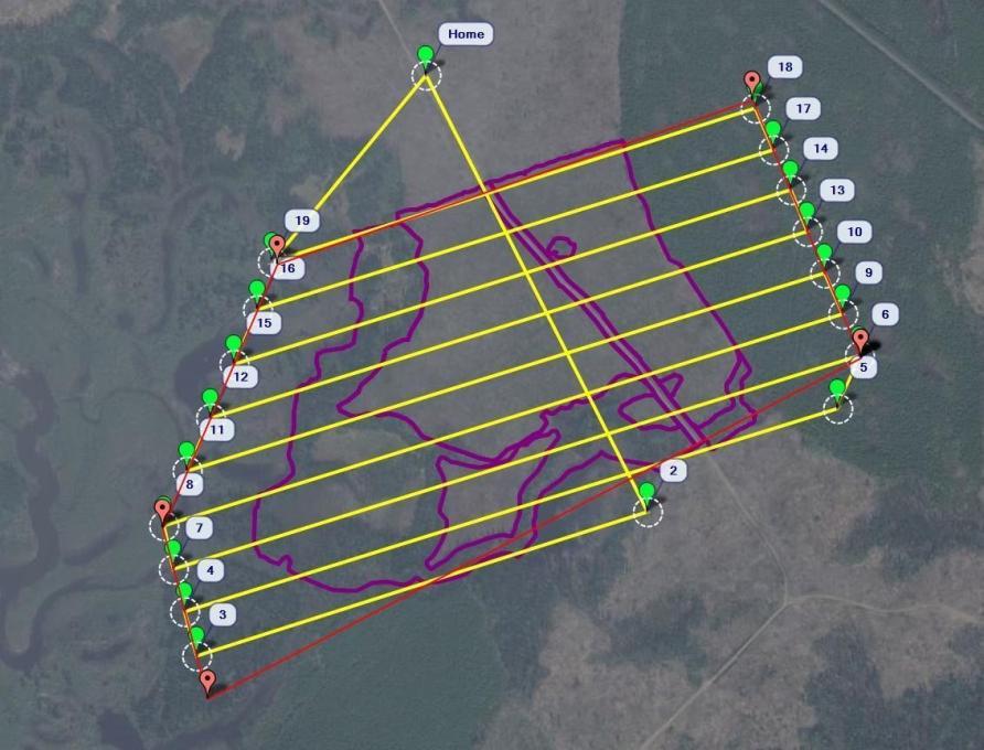
9 Types of UAVs Take-Off/Landing Area VTOL Fixed Wing Speed Slow Fast Range Short Long Small Large Turning Distance None Long Flight Direction Any Forward Mechanical System Complex Simple

10 Sensors DSLR Camera Thermal LiDAR Others (e.g. Multispectral)
11 Transport Canada Regulations Unaided Visual Line of Sight (LOS)

 Ground School")
12 Transport Canada Regulations Unaided Visual Line of Sight (LOS) Ground School Training
 Ground School Training")
13 Transport Canada Regulations Unaided Visual Line of Sight (LOS) Ground School Training Insurance
14 Transport Canada Regulations Unaided Visual Line of Sight (LOS) Ground School Training Insurance Relevant Acts, Regulations, or Laws The Charter of Rights and Freedoms, Criminal Code of Canada; Privacy Act; Personal Information Protection and Electronic Documents Act; Customs Act; Trespass Act; Radiocommunication Act; Environmental Protection Act; National Parks Aircraft Access Regulations; Transportation of Dangerous Goods Act; and Canadian Transportation Accident Investigation and Safety Board Act.

15 Transport Canada Regulations 30 m (or more) away from people, animals, buildings, structures, and vehicles not involved in the operation
 from people/ buildings 9 km from airports/forest")
16 Transport Canada Regulations Unaided Visual Line of Sight (LOS) Ground School Training Insurance Relevant Acts, Regulations, or Laws 30 m (or more) from people/ buildings 9 km from airports/forest fires
17 Resources Transport Canada ral-recavi-uav-2265.htm Unmanned Systems Canada Canadian Centre for Unmanned Vehicle Systems DIY Drones

18 Considerations Access Terrain Slope 12cm 3cm 12cm 3cm

19 Considerations Access Terrain Slope Land Cover

20 Considerations Access Terrain Slope Land Cover Weather Only What Can be Seen in the Photos
21
22 UAV >70% Overlap UAV >60% Overlap

23

24

25
26 Post Processing 10% UAV Data Collection, 90% Post Processing Photogrammetric stereo workstations Advanced in-house and commercial photogrammetric and surveying software Experience with the software and associated workflows
27 Software Pix4D Agisoft Menci AreoHawk SimActive EnsoMosaic UAV Triangulate images Point Cloud DSM Ortho No automated DEM unless bare earth LiDAR software to process point clouds

28 Image Matching
29 Exterior Orientation Photo Easting Northing Altitude Kappa Phi Omega DSC06842.JPG DSC06843.JPG DSC06844.JPG DSC06845.JPG DSC06846.JPG

30

31
")
32 Photography (RGB/NIR) Products

33
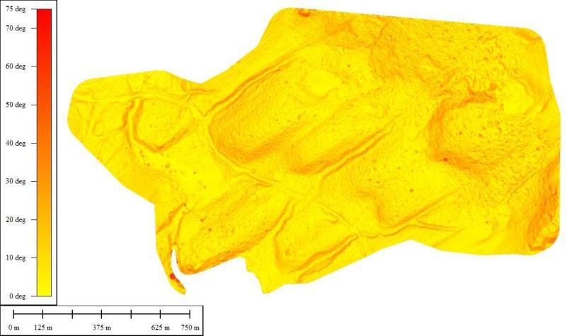
34
 True")
35 Products Photography (RGB/NIR) True Orthomosaics


36

37

38 Satellite-Google Earth

39 Full Scale Airphoto 20cm

40 UAV photo 3cm

41 Products Photography (RGB/NIR) True Orthomosaics Point Clouds

42 Products Photography (RGB/NIR) True Orthomosaics Point Clouds Digital Surface Models (DSM)
 Digital Elevation Models")
43 Products Photography (RGB/NIR) True Orthomosaics Point Clouds Digital Surface Models (DSM) Digital Elevation Models (DEM)
 Digital Elevation Models (DEM) Stereo")
44 Products Photography (RGB/NIR) True Orthomosaics Point Clouds Digital Surface Models (DSM) Digital Elevation Models (DEM) Stereo Models
 Digital Elevation Models (DEM) Stereo Models Planimetric")
45 Products Photography (RGB/NIR) True Orthomosaics Point Clouds Digital Surface Models (DSM) Digital Elevation Models (DEM) Stereo Models Planimetric Data/Contours

46 Volumes

47 Drainage
48 Slope

49 Wildlife Monitoring

50 Vegetation and Habitat


51

52
53 Tree Inventory 130 ha Mature stand Balsam and Spruce
54 Elevation Data

55 Dead Standing Trees

56 Automated Tree Heights

57 Tree Inventory

58 Benefits Safe Data Over Inaccessible Sites Minimal Disturbance Cost-Effective Less Field Time Accurate Variety of Products Snapshot in Time
The X100. Safe and fully automatic. Fast and with survey accuracy. revolutionary mapping. create your own orthophotos and DSMs
 The X100 revolutionary mapping Safe and fully automatic create your own orthophotos and DSMs Fast and with survey accuracy operates even in harsh weather conditions (up to 65 km/h wind & light rain) Image
How To Discuss Unmanned Aircraft System (Uas)
") Unmanned Aerial Systems (UAS) for American Association of Port Authorities Administration and Legal Issues Seminar New Orleans, LA April 9, 2015 Briefly about Flight Guardian Our Services: Educating public
Unmanned Aerial Systems (UAS) for American Association of Port Authorities Administration and Legal Issues Seminar New Orleans, LA April 9, 2015 Briefly about Flight Guardian Our Services: Educating public
Development of Automatic shooting and telemetry system for UAV photogrammetry INTRODUCTION
 Development of Automatic shooting and telemetry system for UAV photogrammetry Jinwoo PARK 1, Minseok KIM 1, Khin Mar Yee 1, Chuluong CHOI 1 1 Department of Spatial Information Engineering, Pukyong National
Photogrammetric Point Clouds
 Photogrammetric Point Clouds Origins of digital point clouds: Basics have been around since the 1980s. Images had to be referenced to one another. The user had to specify either where the camera was in
HEXAGON GEOSPATIAL BENELUX 2015. Hexagon Geospatial Benelux 2015
 HEXAGON GEOSPATIAL BENELUX 2015 IMAGINE for UAV Irmgard Runkel GEOSYSTEMS GmbH, Germany Are drones a new market*? > 50 % * http://dronelife.com/2015/08/28/the-latest-drone-numbers-from-cb-insights-future-of-frontier-tech-report/
MULTIPURPOSE USE OF ORTHOPHOTO MAPS FORMING BASIS TO DIGITAL CADASTRE DATA AND THE VISION OF THE GENERAL DIRECTORATE OF LAND REGISTRY AND CADASTRE
 MULTIPURPOSE USE OF ORTHOPHOTO MAPS FORMING BASIS TO DIGITAL CADASTRE DATA AND THE VISION OF THE GENERAL DIRECTORATE OF LAND REGISTRY AND CADASTRE E.ÖZER, H.TUNA, F.Ç.ACAR, B.ERKEK, S.BAKICI General Directorate
How To Make An Orthophoto
 ISSUE 2 SEPTEMBER 2014 TSA Endorsed by: CLIENT GUIDE TO DIGITAL ORTHO- PHOTOGRAPHY The Survey Association s Client Guides are primarily aimed at other professionals such as engineers, architects, planners
The YellowScan system: A test on the oppida of Nages/Roque de Viou (Languedoc, France) Tristan Allouis, PhD Research and Development, L'Avion Jaune
 Tristan Allouis, PhD Research and Development, L'Avion Jaune") The YellowScan system: A test on the oppida of Nages/Roque de Viou (Languedoc, France) Tristan Allouis, PhD Research and Development, L'Avion Jaune L'Avion Jaune : Earth observation data provider UAVs
The YellowScan system: A test on the oppida of Nages/Roque de Viou (Languedoc, France) Tristan Allouis, PhD Research and Development, L'Avion Jaune L'Avion Jaune : Earth observation data provider UAVs
STATE OF NEVADA Department of Administration Division of Human Resource Management CLASS SPECIFICATION
 STATE OF NEVADA Department of Administration Division of Human Resource Management CLASS SPECIFICATION TITLE PHOTOGRAMMETRIST/CARTOGRAPHER V 39 6.102 PHOTOGRAMMETRIST/CARTOGRAPHER II 33 6.110 PHOTOGRAMMETRIST/CARTOGRAPHER
Opportunities for the generation of high resolution digital elevation models based on small format aerial photography
 Opportunities for the generation of high resolution digital elevation models based on small format aerial photography Boudewijn van Leeuwen 1, József Szatmári 1, Zalán Tobak 1, Csaba Németh 1, Gábor Hauberger
From Pixel to Info-Cloud News at Leica Geosystems JACIE Denver, 31 March 2011 Ruedi Wagner Hexagon Geosystems, Geospatial Solutions Division.
 From Pixel to Info-Cloud News at Leica Geosystems JACIE Denver, 31 March 2011 Ruedi Wagner Hexagon Geosystems, Geospatial Solutions Division What else can I do with my sensor/data? Earth to Image Image
APPLICATION FOR A SPECIAL FLIGHT OPERATIONS CERTIFICATE FOR THE OPERATION OF A RECREATIONAL MODEL UNMANNED AIR VEHICLE (UAV) Revision NC draft
 Revision NC draft") APPLICATION FOR A SPECIAL FLIGHT OPERATIONS CERTIFICATE FOR THE OPERATION OF A RECREATIONAL MODEL UNMANNED AIR VEHICLE (UAV) Revision NC draft Instructions This application format is for the use of model
APPLICATION FOR A SPECIAL FLIGHT OPERATIONS CERTIFICATE FOR THE OPERATION OF A RECREATIONAL MODEL UNMANNED AIR VEHICLE (UAV) Revision NC draft Instructions This application format is for the use of model
METHODOLOGY FOR LANDSLIDE SUSCEPTIBILITY AND HAZARD MAPPING USING GIS AND SDI
 The 8th International Conference on Geo-information for Disaster Management Intelligent Systems for Crisis Management METHODOLOGY FOR LANDSLIDE SUSCEPTIBILITY AND HAZARD MAPPING USING GIS AND SDI T. Fernández
Mapping Earth from Space Remote sensing and satellite images. Remote sensing developments from war
 Mapping Earth from Space Remote sensing and satellite images Geomatics includes all the following spatial technologies: a. Cartography "The art, science and technology of making maps" b. Geographic Information
3D Model of the City Using LiDAR and Visualization of Flood in Three-Dimension
 3D Model of the City Using LiDAR and Visualization of Flood in Three-Dimension R.Queen Suraajini, Department of Civil Engineering, College of Engineering Guindy, Anna University, India, suraa12@gmail.com
High Resolution Digital Surface Models and Orthoimages for Telecom Network Planning
 Renouard, Lehmann 241 High Resolution Digital Surface Models and Orthoimages for Telecom Network Planning LAURENT RENOUARD, S ophia Antipolis FRANK LEHMANN, Berlin ABSTRACT DLR of Germany and ISTAR of
Nighthawk IV UAS. Versatility. User Friendly Design. Capability. Aerial Surveillance Simplified. forcepro@ara.com 800.639.6315 www.ara.
 Aerial Surveillance Simplified The Nighthawk IV small unmanned aerial vehicle brings military hardened technology to civil agencies and commercial user groups. Supremely easy to operate and recently certified
USE OF VERY HIGH-RESOLUTION AIRBORNE IMAGES TO ANALYSE 3D CANOPY ARCHITECTURE OF A VINEYARD
 USE OF VERY HIGH-RESOLUTION AIRBORNE IMAGES TO ANALYSE 3D CANOPY ARCHITECTURE OF A VINEYARD S. Burgos a, *, M. Mota a, D. Noll a, B. Cannelle b a University for Viticulture and Oenology Changins, 1260
UAV Road Surface Monitoring and Traffic Information
 UAV Road Surface Monitoring and Traffic Information Czech Road and Motorway Network New capabilities for Unmanned Aerial Systems Current usage (military operation service) Possible civil usage (possible
Grand Canyon Monitoring and Research Center. Results and Recommendations from the Remote Sensing Initiative
 Grand Canyon Monitoring and Research Center Results and Recommendations from the Remote Sensing Initiative Presentation Order Brief History Objectives General Approach Approach & Results for Specific Monitoring
Table of Contents 1. INTRODUCTION 2 2. DEFINITION 4 3. UAS CLASSIFICATION 6 4. REGULATORY PRINCIPLES 16 5. INTERACTION WITH AIR TRAFFIC CONTROL 16
 FOREWORD Table of Contents 1. INTRODUCTION 2 2. DEFINITION 4 3. UAS CLASSIFICATION 6 4. REGULATORY PRINCIPLES 16 5. INTERACTION WITH AIR TRAFFIC CONTROL 16 6. SENSE AND AVOID ( required for applicants
ACCURACY OF UAV PHOTOGRAMMETRY COMPARED WITH NETWORK RTK GPS
 ACCURACY OF UAV PHOTOGRAMMETRY COMPARED WITH NETWORK RTK GPS P. Barry, R. Coakley Baseline Surveys Ltd Mount Desert Lodge, Lee Road, Cork, Co. Cork - Ireland paudie@baselinesurveys.ie KEY WORDS: UAV, UAS,
Use of RPAS/Drones in Norway
 Use of RPAS/Drones in Norway Publisert: 23 mai 2016 13:05 CEST Oppdatert: 08 jun 2016 09:56 CEST Send på epost About Drones Drones Use of drones, or RPAS (Remotely piloted aircraft system) is regulated
Learn How to Fly a Gatewing X-100 and Why
 The Trimble Gatewing Rapid mapping tool. TSA Discussion Group, 7 Nov 2012 Anthony Mills, Trimble Agenda: Why UAS? Gatewing Results Deliverables Accuracy UK Regulation Why UAS? Economic Hazardous & Hard-to-Reach
Point Clouds: Big Data, Simple Solutions. Mike Lane
 Point Clouds: Big Data, Simple Solutions Mike Lane Light Detection and Ranging Point Cloud is the Third Type of Data Vector Point Measurements and Contours Sparse, highly irregularly spaced X,Y,Z values
Unmanned Airship Based High Resolution Images Acquisition and the Processing
 Unmanned Airship Based High Resolution Images Acquisition and the Processing 1 Qian Yang, 2 Shengbo Chen *, 3 Peng Lu, 4 Mingchang Wang, 5 Qiong Wu, 6 Chao Zhou, 7 Yanli Liu 1 College of Geo-Exploration
3D City Modelling from LIDAR Data
 Chapter 10 3D City Modelling from LIDAR Data Rebecca (O.C.) Tse, Christopher Gold, and Dave Kidner Abstract Airborne Laser Surveying (ALS) or LIDAR (Light Detection and Ranging) becomes more and more popular
Speed Detection for Moving Objects from Digital Aerial Camera and QuickBird Sensors
 Speed Detection for Moving Objects from Digital Aerial Camera and QuickBird Sensors September 2007 Fumio Yamazaki 1, Wen Liu 1, T. Thuy Vu 2 1. Graduate School of Engineering, Chiba University, Japan.
Vorstellung eines photogrammetrischen Kamerasystems für UAVs mit hochgenauer GNSS/INS Information für standardisierte Verarbeitungsverfahren
 Vorstellung eines photogrammetrischen Kamerasystems für UAVs mit hochgenauer GNSS/INS Information für standardisierte Verarbeitungsverfahren T. Kraft a, M. Geßner a, H. Meißner a, H. J. Przybilla b, M.
UAS deployment and data processing during the Balkans flooding with the support to Mine Action
 UAS deployment and data processing during the Balkans flooding with the support to Mine Action Haris Balta; Geert De Cubber; Yvan Baudoin and Daniela Doroftei Department of Mechanics, Unmanned Vehicle
LIDAR and Digital Elevation Data
 LIDAR and Digital Elevation Data Light Detection and Ranging (LIDAR) is being used by the North Carolina Floodplain Mapping Program to generate digital elevation data. These highly accurate topographic
REGISTRATION OF LASER SCANNING POINT CLOUDS AND AERIAL IMAGES USING EITHER ARTIFICIAL OR NATURAL TIE FEATURES
 REGISTRATION OF LASER SCANNING POINT CLOUDS AND AERIAL IMAGES USING EITHER ARTIFICIAL OR NATURAL TIE FEATURES P. Rönnholm a, *, H. Haggrén a a Aalto University School of Engineering, Department of Real
3-D Object recognition from point clouds
 3-D Object recognition from point clouds Dr. Bingcai Zhang, Engineering Fellow William Smith, Principal Engineer Dr. Stewart Walker, Director BAE Systems Geospatial exploitation Products 10920 Technology
Jean François Aumont (1), Bastien Mancini (2). (1) Image processing manager, Delair-Tech, (2) Managing director, Delair-Tech. Project : Authors:
, Bastien Mancini (2). (1) Image processing manager, Delair-Tech, (2) Managing director, Delair-Tech. Project : Authors:") Jean François Aumont (1), Bastien Mancini (2). (1) Image processing manager, Delair-Tech, (2) Managing director, Delair-Tech. White paper DT26X DT-3BANDS XL APXL Project : Authors: Date:
Jean François Aumont (1), Bastien Mancini (2). (1) Image processing manager, Delair-Tech, (2) Managing director, Delair-Tech. White paper DT26X DT-3BANDS XL APXL Project : Authors: Date:
IFSEC 2014. CUAASA and UAS Overview
 IFSEC 2014 CUAASA and UAS Overview Introduction An Unmanned Aerial Vehicle (UAV), Unmanned Aircraft System (UAS) or as named by ICAO as a Remotely Piloted Aircraft (RPA) and commonly known as drone, is
Solving for Camera Exterior Orientation on Historical Images Using Imagine/LPS Version 1.0
 Solving for Camera Exterior Orientation on Historical Images Using Imagine/LPS Version 1.0 Prepared by: Jason Faulring Systems Integration Engineer Laboratory for Imaging Algorithms & Systems Rochester
Advanced Image Management using the Mosaic Dataset
 Esri International User Conference San Diego, California Technical Workshops July 25, 2012 Advanced Image Management using the Mosaic Dataset Vinay Viswambharan, Mike Muller Agenda ArcGIS Image Management
One Survey One Hundred Solutions. TLidar in Africa
 TLidar in Africa Africa Geospatial Forum The Survey Profession 35 Years of Change Johannesburg 19 August 2015 Norman Banks Change & Progress! The reasonable man adapts himself to the world; the unreasonable
Digital Agriculture: Leveraging Technology and Information into Profitable Decisions
 Digital Agriculture: Leveraging Technology and Information into Profitable Decisions Dr. Matt Darr, Ag & Biosystems Engineering Advancing Agricultural Performance and Environmental Stewardship Some material
Control Design of Unmanned Aerial Vehicles (UAVs)
") Control Design of Unmanned Aerial Vehicles (UAVs) Roberto Tempo CNR-IEIIT Consiglio Nazionale delle Ricerche Politecnico di Torino tempo@polito.it Control of UAVs UAVs: Unmanned aerial vehicles of different
Control Design of Unmanned Aerial Vehicles (UAVs) Roberto Tempo CNR-IEIIT Consiglio Nazionale delle Ricerche Politecnico di Torino tempo@polito.it Control of UAVs UAVs: Unmanned aerial vehicles of different
2003 INTERNATIONAL CONFERENCE AIRPORTS: PLANNING, INFRASTRUCTURE & ENVIRONMENT
 AIRPORTS: PLANNING, INFRASTRUCTURE & ENVIRONMENT AIRBORNE AND SPACEBORNE REMOTE SENSING TERRAIN MAPPING FOR PLANNING AND DESIGN OF TRANSPORTATION INFRASTRUCTURE ASSETS Waheed Uddin Associate Professor
ORBIT GEOSPATIAL TECHNOLOGIES BRIDGES THE GAP BETWEEN AIRBORNE AND MOBILE MAPPING
 L. Devriendt, J. Bonne, C. Dumitru Orbit GT Bridges the Gap between Airborne and Mobile Mapping ORBIT GEOSPATIAL TECHNOLOGIES BRIDGES THE GAP BETWEEN AIRBORNE AND MOBILE MAPPING Lomme DEVRIENDT, PhD Orbit
KILN GROUP AVIATION DIVISION UAS INSURANCE PROPOSAL FORM GLOSSARY
 GLOSSARY ATC Air Traffic Control CAA Civil Aviation Authority Comms Abv. Communications GCS Ground Control Station. Including launch system, flight control and mission specific hardware & software, communications
Active and Passive Microwave Remote Sensing
 Active and Passive Microwave Remote Sensing Passive remote sensing system record EMR that was reflected (e.g., blue, green, red, and near IR) or emitted (e.g., thermal IR) from the surface of the Earth.
Imagery. 1:50,000 Basemap Generation From Satellite. 1 Introduction. 2 Input Data
 1:50,000 Basemap Generation From Satellite Imagery Lisbeth Heuse, Product Engineer, Image Applications Dave Hawkins, Product Manager, Image Applications MacDonald Dettwiler, 3751 Shell Road, Richmond B.C.
Utah State General Records Retention Schedule SCHEDULE 1 GEOSPATIAL DATA SETS
 Utah State General Records Retention Schedule SCHEDULE 1 BIOTA RECORDS (Item 1-26) These are geospatial records that depict wildlife use areas in the state of Utah as determined by wildlife biologists
AeroVironment, Inc. Unmanned Aircraft Systems Overview Background
 AeroVironment, Inc. Unmanned Aircraft Systems Overview Background AeroVironment is a technology solutions provider with a more than 40-year history of practical innovation in the fields of unmanned aircraft
EVALUATION OF AIRBORNE LIDAR DIGITAL TERRAIN MAPPING FOR HIGHWAY CORRIDOR PLANNING AND DESIGN
 Waheed Uddin Director, Center for Advanced Infrastructure Technology, Carrier Hall 203 The University of Mississippi, University, MS 38677-1848, USA cvuddin@olemiss.edu KEY WORDS: Terrain, mapping, airborne,
Coastal Engineering Indices to Inform Regional Management
 Coastal Engineering Indices to Inform Regional Management Lauren Dunkin FSBPA 14 February 2013 Outline Program overview Standard products Coastal Engineering Index Conclusion and future work US Army Corps
Files Used in this Tutorial
 Generate Point Clouds Tutorial This tutorial shows how to generate point clouds from IKONOS satellite stereo imagery. You will view the point clouds in the ENVI LiDAR Viewer. The estimated time to complete
Digital Orthophoto Production In the Desktop Environment 1
 Digital Orthophoto Production In the Desktop Environment 1 By Dr. Roy A. Welch and Thomas R. Jordan Digital orthophotos are proving suitable for a variety of mapping, GIS and environmental monitoring tasks.
High Resolution RF Analysis: The Benefits of Lidar Terrain & Clutter Datasets
 0 High Resolution RF Analysis: The Benefits of Lidar Terrain & Clutter Datasets January 15, 2014 Martin Rais 1 High Resolution Terrain & Clutter Datasets: Why Lidar? There are myriad methods, techniques
Digital Image Increase
 Exploiting redundancy for reliable aerial computer vision 1 Digital Image Increase 2 Images Worldwide 3 Terrestrial Image Acquisition 4 Aerial Photogrammetry 5 New Sensor Platforms Towards Fully Automatic
Innovation Made in Germany SIRIUS UAS. www.mavinci.de
 Innovation Made in Germany SIRIUS UAS www.mavinci.de Sirius UAS Advanced flight planning and mission control software Simple and flexible use Simple automatic flight planning Session management Offline
The RapidEye optical satellite family for high resolution imagery
 'Photogrammetric Week 01' D. Fritsch & R. Spiller, Eds. Wichmann Verlag, Heidelberg 2001. Scherer, Krischke 139 The RapidEye optical satellite family for high resolution imagery STEFAN SCHERER and MANFRED
Teaching and Learning Strategies for 3D Urban and Landscape Modelling
 Teaching and Learning Strategies for 3D Urban and Landscape Modelling Martin SMITH, Andrew BURTON, and Nikolaos KOKKAS, United Kingdom Key words: 3D modelling, visualization, teaching, learning SUMMARY
TAMU-CC UAS Program 1
 TAMU-CC UAS Program 1 TAMU-CC Major Research Initiatives Coastal & Marine Economic & environmental sustainability Ecosystem evaluation Shoreline mapping Water supply studies Policy Engineering Science
Hyperspectral Satellite Imaging Planning a Mission
 Hyperspectral Satellite Imaging Planning a Mission Victor Gardner University of Maryland 2007 AIAA Region 1 Mid-Atlantic Student Conference National Institute of Aerospace, Langley, VA Outline Objective
Micro and Mini UAV Airworthiness, European and NATO Activities
 Recent Development in Unmanned Aircraft Systems Micro and Mini UAV Airworthiness, European and NATO Activities iti Fulvia Quagliotti Politecnico di Torino Department of Aerospace Engineering Torino, Italy
Greg Colley, Suave Aerial Photographers
 Greg Colley, Suave Aerial Photographers Use of UAVs and low cost software for surveys of heritage sites 1. Introduction 2. Case Study: Chester Amphitheatre 3. Case Study: Chester Walls 4. Project and Equipment
Geospatial Software Solutions for the Environment and Natural Resources
 Geospatial Software Solutions for the Environment and Natural Resources Manage and Preserve the Environment and its Natural Resources Our environment and the natural resources it provides play a growing
SUPPORTING REMOTE SENSING RESEARCH WITH SMALL UNMANNED AERIAL SYSTEMS
 SUPPORTING REMOTE SENSING RESEARCH WITH SMALL UNMANNED AERIAL SYSTEMS R. C. Anderson*, P. C. Shanks, L. A. Kritis, M. G. Trani National Geospatial-Intelligence Agency (NGA) Robert.C.Anderson@nga.mil, Philip.C.Shanks@nga.mil,
INTEGRATED GEOPHYSICAL AND REMOTE SENSING STUDIES ON GROTTA GIGANTE SHOW CAVE (TRIESTE ITALY) P. Paganini, A. Pavan, F. Coren, A.
 P. Paganini, A. Pavan, F. Coren, A.") INTEGRATED GEOPHYSICAL AND REMOTE SENSING STUDIES ON GROTTA GIGANTE SHOW CAVE (TRIESTE ITALY) P. Paganini, A. Pavan, F. Coren, A. Fabbricatore Aerial lidar survey - strumentation Piper Seneca II - PA34
INTEGRATED GEOPHYSICAL AND REMOTE SENSING STUDIES ON GROTTA GIGANTE SHOW CAVE (TRIESTE ITALY) P. Paganini, A. Pavan, F. Coren, A. Fabbricatore Aerial lidar survey - strumentation Piper Seneca II - PA34
Appendix B. Introduction to Landslide Evaluation Tools Mapping, Remote Sensing, and Monitoring of Landslides
 Appendix B. Introduction to Landslide Evaluation Tools Mapping, Remote Sensing, and Monitoring of Landslides 66 The Landslide Handbook A Guide to Understanding Landslides Part 1. Mapping Maps are a useful
Using Optech LMS to Calibrate Survey Data Without Ground Control Points
 Challenge An Optech client conducted an airborne lidar survey over a sparsely developed river valley. The data processors were finding that the data acquired in this survey was particularly difficult to
VISIONMAP A3 - SUPER WIDE ANGLE MAPPING SYSTEM BASIC PRINCIPLES AND WORKFLOW
 VISIONMAP A3 - SUPER WIDE ANGLE MAPPING SYSTEM BASIC PRINCIPLES AND WORKFLOW Michael Pechatnikov, Erez Shor, Yuri Raizman VisionMap Ltd., www.visionmap.com 13 Mozes St., Tel-Aviv, 67442, Israel michael@visionmap.com,
OBLIQUE AERIAL PHOTOGRAPHY TOOL FOR BUILDING INSPECTION AND DAMAGE ASSESSMENT
 OBLIQUE AERIAL PHOTOGRAPHY TOOL FOR BUILDING INSPECTION AND DAMAGE ASSESSMENT A. Murtiyoso 1, F. Remondino 2, E. Rupnik 2, F. Nex 2, P. Grussenmeyer 1 1 INSA Strasbourg / ICube Laboratory, France Email:
Application for Special Flight Operations Certificate File # ABC123. Company Name Address Phone Email
 Application for Special Flight Operations Certificate File # ABC123 Company Name Address Phone Email NOTE: This sample is provided as is by flitelab.com It is meant for reference only. It should only be
TURNING IMAGES INTO 3D AND 4D MODELS
 TURNING IMAGES INTO 3D AND 4D MODELS Fabio REMONDINO 3D Optical Metrology (3DOM) Bruno Kessler Foundation (FBK) Trento, Italy Email: remondino@fbk.eu http://3dom.fbk.eu Cultural Herritage: Monuments /
PERFORMANCE TEST ON UAV-BASED PHOTOGRAMMETRIC DATA COLLECTION
 PERFORMANCE TEST ON UAV-BASED PHOTOGRAMMETRIC DATA COLLECTION Norbert Haala a, *, Michael Cramer a, Florian Weimer b, Martin Trittler b a Institute for Photogrammetry, University of Stuttgart [firstname.lastname]@ifp.uni-stuttgart.de
AirborneHydroMapping. New possibilities in bathymetric and topographic survey
 AirborneHydroMapping New possibilities in bathymetric and topographic survey AIRBORNE HYDROMAPPING (2008 2011) Layout needs from water engineering side: - Shallow water applications - High point density
Integer Computation of Image Orthorectification for High Speed Throughput
 Integer Computation of Image Orthorectification for High Speed Throughput Paul Sundlie Joseph French Eric Balster Abstract This paper presents an integer-based approach to the orthorectification of aerial
2.3 Spatial Resolution, Pixel Size, and Scale
 Section 2.3 Spatial Resolution, Pixel Size, and Scale Page 39 2.3 Spatial Resolution, Pixel Size, and Scale For some remote sensing instruments, the distance between the target being imaged and the platform,
How To Fuse A Point Cloud With A Laser And Image Data From A Pointcloud
 REAL TIME 3D FUSION OF IMAGERY AND MOBILE LIDAR Paul Mrstik, Vice President Technology Kresimir Kusevic, R&D Engineer Terrapoint Inc. 140-1 Antares Dr. Ottawa, Ontario K2E 8C4 Canada paul.mrstik@terrapoint.com
REPORT TO REGIONAL WATER SUPPLY COMMISSION MEETING OF WEDNESDAY, SEPTEMBER 4, 2013 LEECH WATER SUPPLY AREA RESTORATION UPDATE
 Making a difference... together Agenda Item #9 REPORT #RWSC 2013-17 REPORT TO REGIONAL WATER SUPPLY COMMISSION MEETING OF WEDNESDAY, SEPTEMBER 4, 2013 SUBJECT LEECH WATER SUPPLY AREA RESTORATION UPDATE
AN INVESTIGATION OF THE GROWTH TYPES OF VEGETATION IN THE BÜKK MOUNTAINS BY THE COMPARISON OF DIGITAL SURFACE MODELS Z. ZBORAY AND E.
 ACTA CLIMATOLOGICA ET CHOROLOGICA Universitatis Szegediensis, Tom. 38-39, 2005, 163-169. AN INVESTIGATION OF THE GROWTH TYPES OF VEGETATION IN THE BÜKK MOUNTAINS BY THE COMPARISON OF DIGITAL SURFACE MODELS
Preface. Ko Ko Lwin Division of Spatial Information Science University of Tsukuba 2008
 1 Preface Remote Sensing data is one of the primary data sources in GIS analysis. The objective of this material is to provide fundamentals of Remote Sensing technology and its applications in Geographical
Onboard electronics of UAVs
 AARMS Vol. 5, No. 2 (2006) 237 243 TECHNOLOGY Onboard electronics of UAVs ANTAL TURÓCZI, IMRE MAKKAY Department of Electronic Warfare, Miklós Zrínyi National Defence University, Budapest, Hungary Recent
The Status of Geospatial Information Management in China
 The Status of Geospatial Information Management in China Submitted by the National Administration of Surveying, Mapping and Geoinformation of China 1. Administration System The National Administration
Drones: All Abuzz with Privacy & Security Issues
 SESSION ID: LAW-R01 Drones: All Abuzz with Privacy & Security Issues Dr. Christopher T. Pierson, J.D. EVP, General Counsel & Chief Security Officer Viewpost James T. Shreve, J.D. Attorney BuckleySandler
FedEx, Rolls Royce and UPS know And so do Google, Facebook, Amazon and Intel
 FedEx, Rolls Royce and UPS know And so do Google, Facebook, Amazon and Intel The next great U.S. industrial cycle AUVSI s 2013 Economic Report: www.auvsi.org/econreport The UAS global market is currently
Andrea Bondì, Irene D Urso, Matteo Ombrelli e Paolo Telaroli (Thetis S.p.A.) Luisa Sterponi e Cesar Urrutia (Spacedat S.r.l.) Water Calesso (Marco
 Luisa Sterponi e Cesar Urrutia (Spacedat S.r.l.) Water Calesso (Marco") Generation of a digital elevation model of the Wadi Lebda basin, Leptis Magna - Lybia Andrea Bondì, Irene D Urso, Matteo Ombrelli e Paolo Telaroli (Thetis S.p.A.) Luisa Sterponi e Cesar Urrutia (Spacedat
Generation of a digital elevation model of the Wadi Lebda basin, Leptis Magna - Lybia Andrea Bondì, Irene D Urso, Matteo Ombrelli e Paolo Telaroli (Thetis S.p.A.) Luisa Sterponi e Cesar Urrutia (Spacedat
Mr. Jay Arnold, Magnolia River Mr. Richard Vincent, McKim & Creed
 Mr. Jay Arnold, Magnolia River Mr. Richard Vincent, McKim & Creed Why Change? Electric Utility Safety and Reliability NERC FAC- 008 and FAC-003 As Built Infrastructure monitor vegetation annual requirement
of large scale imagery without GPS
 Titelmaster Online geocoding and evaluation of large scale imagery without GPS Wolfgang Förstner, Richard Steffen Department of Photogrammetry Institute for Geodesy and Geoinformation University of Bonn
Lidar 101: Intro to Lidar. Jason Stoker USGS EROS / SAIC
 Lidar 101: Intro to Lidar Jason Stoker USGS EROS / SAIC Lidar Light Detection and Ranging Laser altimetry ALTM (Airborne laser terrain mapping) Airborne laser scanning Lidar Laser IMU (INS) GPS Scanning
Regional Basemap Committee
 Regional Basemap Committee Minutes Wednesday ~ ~ 2:00 P.M. Washoe County Administration Engineering Conference Room 1001 East Ninth Street, Reno, Nevada MEMBERS Gary Beekman, Chair Valerie Johnson, Vice-chair
Methane to Markets Oil and Natural Gas Technology Transfer Workshop
 Methane to Markets Oil and Natural Gas Technology Transfer Workshop Airborne Differential Absorption Lidar (DIAL) Detection and Measurement of Fugitive Emissions Steven Stearns ANGEL Service ITT Space
IP-S2 Compact+ 3D Mobile Mapping System
 IP-S2 Compact+ 3D Mobile Mapping System 3D scanning of road and roadside features Delivers high density point clouds and 360 spherical imagery High accuracy IMU options without export control Simple Map,
Projeto Redentor White Paper
 Projeto Redentor White Paper Projeto Redentor: High-resolution 3D modelling of large, hard-to-reach objects How can one create a highly accurate 3D model of large objects, in hard-to-reach locations, for
29.01.2015. Industry and Business Applications. Industry and Business Applications
 Industry and Business Applications ETH Zürich 30 January 2015 Dr. Jürg Wildi Vice President Technology RUAG Aviation 1 Industry and Business Applications Where is the business for the industry? A Swiss
Evaluation of surface runoff conditions. scanner in an intensive apple orchard
 Evaluation of surface runoff conditions by high resolution terrestrial laser scanner in an intensive apple orchard János Tamás 1, Péter Riczu 1, Attila Nagy 1, Éva Lehoczky 2 1 Faculty of Agricultural
3D VISUALIZATION OF GEOTHERMAL WELLS DIRECTIONAL SURVEYS AND INTEGRATION WITH DIGITAL ELEVATION MODEL (DEM)
") Presented at Short Course VII on Exploration for Geothermal Resources, organized by UNU-GTP, GDC and KenGen, at Lake Bogoria and Lake Naivasha, Kenya, Oct. 27 Nov. 18, 2012. GEOTHERMAL TRAINING PROGRAMME
Presented at Short Course VII on Exploration for Geothermal Resources, organized by UNU-GTP, GDC and KenGen, at Lake Bogoria and Lake Naivasha, Kenya, Oct. 27 Nov. 18, 2012. GEOTHERMAL TRAINING PROGRAMME
<Insert Picture Here> Data Management Innovations for Massive Point Cloud, DEM, and 3D Vector Databases
 Data Management Innovations for Massive Point Cloud, DEM, and 3D Vector Databases Xavier Lopez, Director, Product Management 3D Data Management Technology Drivers: Challenges & Benefits
IAI/Malat Solutions for the Maritime Arena
 IAI/Malat Solutions for the Maritime Arena Any country with a proximity to the sea has an important operational need to positively and unambiguously identify, in time, threats that originate in the maritime
The University of Florida Unmanned Aircraft Systems Research Program: Lessons Learned and an Update on Selected Natural Resources Applications
 The University of Florida Unmanned Aircraft Systems Research Program: Lessons Learned and an Update on Selected Natural Resources Applications Matthew A. Burgess R.R. Carthy, B.E. Wilkinson, T.J. Whitley,
Deployment of Advanced Technologies in Mari8me Security: Effec8ve use of Unmanned Aerial Surveillance Systems
 Deployment of Advanced Technologies in Mari8me Security: Effec8ve use of Unmanned Aerial Surveillance Systems March 11, 2015 Presented by: Richard Garcia, PhD Southwest Research Ins%tute 210-522- 3786
The Lone Star UAS Test Site
 The Lone Star UAS Test Site An update Scientific Committee for Oceanographic Aircraft Research San Diego, CA June 4-5 2014 Mike Starek (presenter) Assistant Professor at Texas A&M University-Corpus Christi
A framework for disaster early recovery support using CIM model based on Photogrammetric Techniques
 A framework for disaster early recovery support using CIM model based on Photogrammetric Techniques Katsunori Miyamoto 1 1 Systems Engineering Department, Japan Construction Information Center Foundation,
10000 pixels wide CMOS frame imager for earth observation from a HALE UAV
 10000 pixels wide CMOS frame imager for earth observation from a HALE UAV B. Delauré a, S. Livens a, J. Everaerts a, R. Kleihorst a, G. Schippers b, Yannick De Wit b, John Compiet b, Bartosz Banachowicz
UAS OPERATORS INSURANCE PROPOSAL FORM
 GLOSSARY ATC Air Traffic Control CAA Civil Aviation Authority Comms Abv. Communications GCS Ground Control Station. Including launch system, flight control and mission specific hardware & software, communications