EO Applications in India for governance & citizens
|
|
|
- Chloe Crawford
- 8 years ago
- Views:
Transcription
1 EO Applications in India for governance & citizens Vinay K Dadhwal ISRO/ India Presentation by Indian Delegation at 56 th Session of UNCOPUOS, June 2013, Vienna

2 Background 1.21 billion population, 68.8 % rural in 600,000+ villages, 22 official languages & 240,000+ local bodies govern in multi-tiered democracy I Census, 2011 ] 3 rd largest internet users (150 million), 900 million mobile subscribers Challenges remain with respect to natural resources, exposure to disasters, economic growth, infrastructure, inequity, access to government services Number of policy, ICT initiatives to address challenges & achieve MDG goals UNIQUE APPLICATION-CENTRIC SPACE PROGRAMME
![] 3 rd largest internet users (150 million), 900 million mobile subscribers Challenges remain with respect to natural](/docs-images/58/3987376/images/page_2.jpg "resources, exposure to disasters, economic growth, infrastructure, inequity, access to government services Number of policy,")
3 National e-governance e initiative NeGP (2006) ; 27 MMP (Mission Mode Projects) Make all Government services accessible to the common man in his locality through Common Service delivery outlets and ensure efficiency, transparency & reliability of such services at affordable costs to realise the basic needs of the common man. Central Missions : 9 : Taxes, Banking, Insurance, Pension, Passport, Immigration, State Missions : 11 : Agriculture,Land,Local Bodies,Police,Taxes,Transport, Employment Integrated Missions : 7 : Courts, Procurement, Biz, INDIA PORTAL, COMMON SERVICE CENTRE, Plan to establish 100,000 Common Service Centres Challenge: ICT for Governance & Citizens to Geo-ICT

4 Applications of Indian Space Program Communication satellites INSAT & GSAT ca. 200 transponders in space Dedicated transponders for education, societal services,incl. (disaster-vpn) Earth Observation Satellites 25 years Continuous observation from IRS-1A(1988) and follow-on Resourcesat, Oceansat, Cartosat series Geostationary meteorological and orbiting science satellites Positioning, navigation & timing services GAGAN (GPS-aided geoaugmentation navigation) IRNSS (Indian Regional Navigation Satellite System)

5 SOLUTION Appropriate technology-based and sustainable solutions for governance as well as for citizens e-governance Initiatives (Non Geospatial) OUTPUTS Geospatial Near-real time Interpretation Models Establish end-to-end n.r.t. EO data supply, interpretation/outputs, GIS basic framework, web-access with open source tools : BHUVAN Web-GIS Portal

6 EO Applications & Governance Good governance can be done with spatial planning (Geomatics) [EO + GIS layers + non-spatial attributes + decision support tools] Info needs : (i) reliable data, (ii) planning to reach high priority target areas, (iii) monitoring program implementation, Challenges : Internalization (capacity to absorb space application); Unified working of internal MIS with geospatial data Recent examples : Land Resource (wasteland), Drinking Water, Urban Planning, Disaster Management, Environment Protection, Information support for Decentralized Planning (SiSDP)
, Drinking Water, Urban Planning, Disaster Management, Environment Protection, Information support for Decentralized Planning")
7 Wasteland Monitoring A targeted Rural Development Programme to bring more land under cultivation Wasteland Map ( ) National Wasteland Inventory Project ( ) National Wasteland Updation Mission ( ) Monitoring of the wasteland areas ( ) Wasteland Change Analysis / 3 date LISS-III ( ) Maps at 1:50,000 scale / Wasteland classes : 28 Maps accessible via BHUVAN Area (Mha) % of TGA Year of Data % % % % 2009
 % of TGA Year of Data 63. 85 20.17% 1986-2000 55.27 17.45% 2003 47.22 14.91% 2005 46.73 14.")
8 Rajiv Gandhi National Drinking Water Mission Mapping of Rock types, Geomorphology, Structure Groundwater Exploration & Recharge sites Ground Water Prospects - Depth & Yield Identification of potable drinking water sources for problematic habitations Hydrologic information (Surface water bodies) G.W. exploitation (Irrigated area) Conduits - GW movement (Fracture /Lineament) Barriers - GW movement (Dolerite dyke) > 296,000 Bore wells drilled using Ground Water Potential Maps (93% Success rate) > 9,000 Recharge structures constructed
 Conduits - GW movement (Fracture /Lineament) Barriers - GW movement (Dolerite dyke) > 296,000 Bore")
9

10 National Urban Information System (NUIS) (Towards administering Towns/ Cities in a Scientific Manner) Multi scale (10K, 2K,1K) hierarchical Urban Geospatial database For supporting Urban Planning, Infrastructure development, e-governance,.. Base No. of Towns : 152 Area : 55,755 sq.km Urban Landuse Metro Class I Class II Class III Class IV Class V Class VI

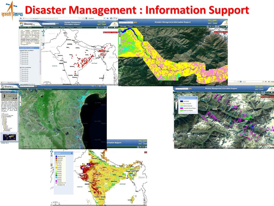
11 Disaster Management Support (DMS) System Space Technology in mitigating Disasters Multi-tier databases with query/ decision tools Observational Systems Satellite (GEO, LEO, Allweather), Aerial, Ground Drought Monthly & End-of-Season Agri Drought Assessment Forest Fire Active fire detection Damage assessment Monitoring of Flood Bogolipather * Post-Flood Image Flood Inundation Flood Inundation Ri ve r Feb, 2012 Br ah m ap ut ra Landslide Damage Assessment Hazard zonation * Demow Bogolipather * Earthquake Damage Assessment Ri ve r Cyclone Inundation mapping Damage assessment Flood Inundation monitoring Damage assessment Hazard zonation Bank erosion studies Pre-Flood Image Br ah m ap ut ra Disasters - Operationally addressed Flood Inundation June 29, 2012 * Demow

12 Bhuvan -Gateway to Indian EO Data Products & Services Prototype Visualisation Data Archive Thematic Services Geo-Processing Availability of Seamless High Resolution Data Multi-Sensor, Temporal, Resolution Data from IRS Satellites Rich Thematic Information Weather Data from ISRO AWS Ocean Services Collaboration / Sharing / Community Participation OGC Web Services Website of the Month Dec 2010 What is Unique in Bhuvan? Online Shape file Creation Terrain Profile Urban Design Tools 3D Fly Through Multi-Lingual (English Hindi Tamil Telugu Gujarati Marati Kannada --) Data Download (CartoDEM, AWiFS, LISS III Ortho)
 Data")
13 Bhuvan Applications for Ministries Irrigation infrastructure monitoring National Urban Information System (Master plan updation)

14 Disaster Management : Information Support
15 Eco-sensitive Zonation of Western Ghats Western Ghats are unique ecosystem with large biodiversity, Min. Environment & Forests established a High Level Working Group to define eco-sensitive zone and define policies for development Total ecosensitive area - 59,940 sq km (36.49%).

16 EO Applications & Citizens Accessible geospatial information to citizens for their economic activity, sustainable development, environment & disaster risk reduction Current examples ECONOMIC ACTIVITY : Potential fishery zone forecast SUST DEVELOP : Action Plan Soil & water conservation ENVIRONMENT : Urban Planning Master Plans DISASTER RISK REDUCTION : Hazard Zonation Flood, Landslides,... : Disaster Forewarning Cyclone, Flood,

17 Potential Fishery Zone Forecast Operational application over two decades with continuous improvements in methodology and outreach. Uses Oceansat data & operational agency INCOIS in Min. Earth Science Methodology Evolution : SST extracted features (1990s), SST + Chlorophyll (2000s), SST, Chl, Wind Vectors (2010s), new approach with model assimilation & model derived SST Uses radio, electronic and SMS based dissemination
, new approach with model assimilation & model derived SST Uses radio,")
18 Hazard Zonation for Disaster Risk Reduction Multi-year in-season inundation mapping for flood hazard zonation (with overlaid of village boundaries) open access through BHUVAN Mitigation Assam-Flood Hazard Atlas Prepared based on 94 satellite data sets acquired during different magnitudes of floods during

19 Village Resource Centre (VRC) VRC : Tele-education Tele-Health Natural Resource Data Advisory Services Single Window Delivery Mechanism Land and Water Resources Weather & Disaster info Tele education & Tele healthcare services Advisories on Agriculture, Fisheries Enhanced livelihood opportunities Info on Price, Market, Pests, Diseases, Livestock, Govt. schemes, job opportunities, etc. VRC Coverage: States/ UT : 22 No. of VRC : 461 Expert Centres/Hospitals : 81 No. of Programmes : 6500

20 BHUVAN Services Municipal GIS for Ludhiana city Flood Hazard Zonation > 10 year data Query, processing

21 Thank You for your kind attention
Vinay K Dadhwal Director. 50 th Session of Scientific & Technical Subcommittee of COPUOS, 11-22 Feb., 2013, Vienna
 Vinay K Dadhwal Director 50 th Session of Scientific & Technical Subcommittee of COPUOS, 11-22 Feb., 2013, Vienna Demonstrated applications of EO for natural resources, infrastructure, planning & disaster
Bhuvan. Indian Earth Observation Visualization. Indian Space Research Organisation. http://bhuvan.nrsc.gov.in. Multi Resolution. Societal Applications
 Multi Resolution Bhuvan Societal Applications Indian Earth Observation Visualization http://bhuvan.nrsc.gov.in 3D Geographic Models Seamless Fly Through Indian Space Research Organisation Thematic Vectors
Gram Panchayat & Ward Boundary Delineation and Assets mapping
 Gram Panchayat & Ward Boundary Delineation and Assets mapping For Rural Development Department & State Election Commission, Govt. of Maharashtra MAHARASHTRA REMOTE SENSING APPLICATIONS CENTRE Autonomous
an insight into systems from acquisition to dissemination
 an insight into systems from acquisition to dissemination P Shasidhar Reddy Manager Computer Systems National Remote Sensing Centre Satellite data acquisition planning, reception, processing and dissemination
Development of Rural Drinking Water Security Plan A Case Study from Raipur Block, Bhilwara District, Rajasthan
 Development of Rural Drinking Water Security Plan A Case Study from Raipur Block, Bhilwara District, Rajasthan Dr. B. K. Bhadra Scientist/Engr. SF Regional Remote Sensing Centre (RRSC-W) NRSC/ISRO, Dept.
ENABLING HETEROGENOUS MULTI-SCALE DATABASE FOR EMERGENCY SERVICE FUNCTIONS THROUGH GEOINFORMATION TECHNOLOGIES
 ENABLING HETEROGENOUS MULTI-SCALE DATABASE FOR EMERGENCY SERVICE FUNCTIONS THROUGH GEOINFORMATION TECHNOLOGIES V.Bhanumurthy, K. Venugopala Rao, S. Srinivasa Rao, K.Ram Mohan Rao *, P.Satya Chandra, J.
Disaster Risk Assessment:
 Disaster Risk Assessment: Disaster Risk Mapping Dr. Jianping Yan Disaster Risk Assessment Specialist Session Outline Essentials on Risk Mapping Map scale, grid size, aggregation unit Requirements for Risk
Near Real Time Flood Mapping & Monitoring
 Near Real Time Flood Mapping & Monitoring C.M.BHATT Disaster Management Support Division National Remote Sensing Centre (NRSC / ISRO) Hyderabad, India flood@nrsc.gov.in 7-8 December, 2014 ISPRS PRE-SYMPOSIUM
25 Years of Indian Remote Sensing Satellite (IRS) Series
 Series") 25 Years of Indian Remote Sensing Satellite (IRS) Series Vinay K Dadhwal Director National Remote Sensing Centre (NRSC), ISRO Hyderabad, INDIA 50 th Session of Scientific & Technical Subcommittee of COPUOS,
25 Years of Indian Remote Sensing Satellite (IRS) Series Vinay K Dadhwal Director National Remote Sensing Centre (NRSC), ISRO Hyderabad, INDIA 50 th Session of Scientific & Technical Subcommittee of COPUOS,
Integrated Water Resources Science and Services. National Water Center
 TOO MUCH POOR QUALITY TOO LITTLE Integrated Water Resources Science and Services and the National Water Center Partnering to Address America s Water Resources Information Needs Mary G. Mullusky National
Utilizing satellite-based information for disaster risk assessment- why and how?
 Utilizing satellite-based information for disaster risk assessment- why and how? Peeranan Towashiraporn ADPC Session 1, UN International Conference on Space-based Technologies for Disaster Management September
Domestic Policy Framework on Adaptation to Climate Change in Water Resources: Case Study for India. Working Together to Respond to Climate Change
 Domestic Policy Framework on Adaptation to Climate Change in Water Resources: Case Study for India Working Together to Respond to Climate Change WATER ACCOUNTING OF INDIA S TOTAL WATER RESOURCES Unutilizable
GIS BASED LAND INFORMATION SYSTEM FOR MANDAL SOUM, SELENGE AIMAG OF MONGOLIA
 GIS BASED LAND INFORMATION SYSTEM FOR MANDAL SOUM, SELENGE AIMAG OF MONGOLIA B. Tuul GTZ, Land Management and Fiscal Cadastre project, Government building 12, ALAGCaC, Ulaanbaatar, Mongolia tuul1119@yahoo.com,
Regional Cooperation on Application of Science and Technology for Disaster Risk Reduction and Management in South Asia
 Regional Cooperation on Application of Science and Technology for Disaster Risk Reduction and Management in South Asia Road Map SAARC Workshop on Application of Science and Technology for Disaster Risk
Survey and Mapping Activities in Vietnam *
 UNITED NATIONS E/CONF.100/CRP.1 ECONOMIC AND SOCIAL COUNCIL Eighteenth United Nations Regional Cartographic Conference for Asia and the Pacific Bangkok, 26-29 October 2009 Item 7(a) of the provisional
Remote Sensing and GIS Application In Change Detection Study In Urban Zone Using Multi Temporal Satellite
 Remote Sensing and GIS Application In Change Detection Study In Urban Zone Using Multi Temporal Satellite R.Manonmani, G.Mary Divya Suganya Institute of Remote Sensing, Anna University, Chennai 600 025
Oregon. Climate Change Adaptation Framework
 Oregon Climate Change Adaptation Framework Oregon Environmental Quality Commission Climate Change Adaptation Framework Presentation at a glance: Purposes of the framework Participating agencies Climate
DISASTER RISK DETECTION AND MANAGEMENT COURSES SETUP SCENARIO AT MAKERERE UNIVERSITY. Makerere University
 DISASTER RISK DETECTION AND MANAGEMENT COURSES SETUP SCENARIO AT MAKERERE UNIVERSITY CASE OF THE DEPARTMENT OF GEOGRAPHY Derek Muhwezi 2 MISSION OF THE DEPARTMENT To provide and promote quality education,
Utilizing space and GIS for effective disaster risk management -ESCAP's practices in Asia and the Pacific
 Utilizing space and GIS for effective disaster risk management -ESCAP's practices in Asia and the Pacific Mr. Keran Wang Chief, Space Applications Section Information and Communications Technology and
Chapter Contents Page No
 Chapter Contents Page No Preface Acknowledgement 1 Basics of Remote Sensing 1 1.1. Introduction 1 1.2. Definition of Remote Sensing 1 1.3. Principles of Remote Sensing 1 1.4. Various Stages in Remote Sensing
New challenges of water resources management: Title the future role of CHy
 New challenges of water resources management: Title the future role of CHy by Bruce Stewart* Karl Hofius in his article in this issue of the Bulletin entitled Evolving role of WMO in hydrology and water
Disaster Management Support - Experience of ISRO
 The Role of Communication & Meteorological Satellites in Disaster Management Support - Experience of ISRO Presentation By Indian Delegation 43 rd Session of S&T Session of UN COPUOS 23 rd Feb. 2006, Vienna
The Global Earth Observation System of Systems (GEOSS) 10-Year Implementation Plan. (As adopted 16 February 2005)
 10-Year Implementation Plan. (As adopted 16 February 2005)") The Global Earth Observation System of Systems (GEOSS) 10-Year Implementation Plan (As adopted 16 February 2005) Preamble Understanding the Earth system its weather, climate, oceans, atmosphere, water,
The Global Earth Observation System of Systems (GEOSS) 10-Year Implementation Plan (As adopted 16 February 2005) Preamble Understanding the Earth system its weather, climate, oceans, atmosphere, water,
Indian Space Programme -Update on activities (Feb 2015)
") Indian Space Programme -Update on activities (Feb 2015) Vinay K Dadhwal India Director, National Remote Sensing Centre (NRSC), INDIAN SPACE RESEARCH ORGANISATION 52 nd Science & Technology Sub-Committee,
Indian Space Programme -Update on activities (Feb 2015) Vinay K Dadhwal India Director, National Remote Sensing Centre (NRSC), INDIAN SPACE RESEARCH ORGANISATION 52 nd Science & Technology Sub-Committee,
AMESD/MESA & GMES and Africa
 AMESD/MESA & GMES and Africa Jolly Wasambo AUC-REA Outline Background MESA: objective and expected results Thematic actions & services Some concerns about natural resources Land degradation Loss of soil
Application of Google Earth for flood disaster monitoring in 3D-GIS
 Disaster Management and Human Health Risk II 271 Application of Google Earth for flood disaster monitoring in 3D-GIS M. Mori & Y. L. Chan Department of Information and Computer Science, Kinki University,
Innovative E-Government Best Practices in Early Warning System for Disaster Risk Management: Bangladesh Experience
 Innovative E-Government Best Practices in Early Warning System for Disaster Risk Management: Bangladesh Experience Dilder Ahmed (Joint Secretary) Project Director ECRRP-D-1 Department of Disaster Management.
Cartosat-1 10 years and beyond
 nrsc Cartosat-1 10 years and beyond Cartosat-1 : 10 years completion in Orbit (2005-2015) 5th May 2015 National Remote Sensing Centre Indian Space Research Organisation Dept. of Space, Govt. of India Balanagar,
INDIVIDUAL COURSE DETAILS
 INDIVIDUAL COURSE DETAILS A. Name of Institution NATIONAL INSTITUTE OF TECHNICAL TEACHERS TRAINING AND RESEARCH TARAMANI CHENNAI 600 113 [An Autonomous Institute under Ministry of Human Resource Development,
Environmental Data Services for Delaware:
 Environmental Data Services for Delaware: Serving Emergency Responders, Planners, and Researchers Network Delaware Day November 6, 2013 Overview Operational Data Services More than just research DEOS and
NATIONAL REMOTE SENSNG CENTRE (ISRO, Department of Space, Govt. of India) nrsc
 nrsc") nrsc NATIONAL REMOTE SENSNG CENTRE (ISRO, Department of Space, Govt. of India) Balanagar, Hyderabad 500 037 Expression of Interest (EOI) for Engaging reputed geospatial industry on preparation of Large
nrsc NATIONAL REMOTE SENSNG CENTRE (ISRO, Department of Space, Govt. of India) Balanagar, Hyderabad 500 037 Expression of Interest (EOI) for Engaging reputed geospatial industry on preparation of Large
Developing Capacities for Risk Management and Resilience
 Developing Capacities for Risk Management and Resilience Dr. Kishan Khoday Regional Cluster Leader Climate Change & Resilience UNDP Regional Center in Cairo (kishan.khoday@undp.org) 0 Context As noted
INDONESIA - LAW ON WATER RESOURCES,
 Environment and Development Journal Law LEAD INDONESIA - LAW ON WATER RESOURCES, 2004 VOLUME 2/1 LEAD Journal (Law, Environment and Development Journal) is a peer-reviewed academic publication based in
Guideline for Stress Testing the Climate Resilience of Urban Areas
 Netherlands Ministry of Infrastructure and Environment Delta Programme Urban Development and Reconstruction Guideline for Stress Testing the Climate Resilience of Urban Areas Extended summary Version 1.0
Maximising economic growth and UK leadership in Earth Observation
 Maximising economic growth and UK leadership in Earth Observation Beth Greenaway, Head of Earth Observation 23 March 2015 http://www.bis.gov.uk/ukspaceagency Overview UK Space Agency EO Importance and
7th Framework Programme Theme 6 Environment (including climate change)
") 7th Framework Programme Theme 6 Environment (including climate change) «Environnement» et «Énergie» Programme D. Deybe DG RTD Environment Directorate 1 Cooperation Collaborative Research Ten themes 1.
7th Framework Programme Theme 6 Environment (including climate change) «Environnement» et «Énergie» Programme D. Deybe DG RTD Environment Directorate 1 Cooperation Collaborative Research Ten themes 1.
SECTOR ASSESSMENT (SUMMARY): CLIMATE CHANGE. 1. Sector Performance, Problems, and Opportunities
: CLIMATE CHANGE. 1. Sector Performance, Problems, and Opportunities") Climate Resilience Sector Project (RRP TON 46351) Sector Road Map SECTOR ASSESSMENT (SUMMARY): CLIMATE CHANGE 1. Sector Performance, Problems, and Opportunities 1. Tonga is being affected by climate change,
Climate Resilience Sector Project (RRP TON 46351) Sector Road Map SECTOR ASSESSMENT (SUMMARY): CLIMATE CHANGE 1. Sector Performance, Problems, and Opportunities 1. Tonga is being affected by climate change,
How To Manage A Flood In Mozambique
 Flood Risk Management in Mozambique and Sub-regional Trans-boundary Issues UNFCCC regional expert meeting on loss and damage in Addis Ababa, Ethiopia from 13 to 15 June 2012 Ron Cadribo, UNISDR DRR Advisor,
ROLE OF REMOTE SENSING AND ITS APPLICATIONS IN DISASTER MANAGEMENT LIKE EARTHQUAKE, FLOOD AND TSUNAMIS. Rajeev 1, Tanuja 2,
 ROLE OF REMOTE SENSING AND ITS APPLICATIONS IN DISASTER MANAGEMENT LIKE EARTHQUAKE, FLOOD AND TSUNAMIS. Rajeev 1, Tanuja 2, Abstract: This study highlights the use of remote sensing technologies in disaster
Insurance environment in India: Bottlenecks and opportunities for a cost effective insurance products. Srinivasa Rao Gattineni
 Insurance environment in India: Bottlenecks and opportunities for a cost effective insurance products Srinivasa Rao Gattineni Rainfall variability is dominant due to the presence of the Monsoon (seasonal
International coordination for continuity and interoperability: a CGMS perspective
 International coordination for continuity and interoperability: a CGMS perspective Peng Zhang, CGMS WG-III Co-Chair NSMC/CMA In Cooperation with Suzanne Hilding, CGMS WG-III Co-Chair OPPA/NESDIS/NOAA 1
Apr. 14, 2008. YongSeob Lee. Deputy Director Korea Secretariat for GEO Climate Policy Division Korea Meteorological Administration
 Apr. 14, 2008 YongSeob Lee Deputy Director Korea Secretariat for GEO Climate Policy Division Korea Meteorological Administration National Strategic Committee for responding to GEOSS Consisting of high
The needs on big data management for Operational Geo-Info Services: Emergency Response, Maritime surveillance, Agriculture Management
 Copernicus Big-Data Workshop 2014, 13/14 March The needs on big data management for Operational Geo-Info Services: Emergency Response, Maritime surveillance, Agriculture Management Marco Corsi e-geos 1
4 th WORLD WATER FORUM. Risk Management in the Iullemeden Aquifer System. 4th World Water Forum, Mexico 2006
 4 th WORLD WATER FORUM Risk Management in the Iullemeden Aquifer System Mexico, Marsh 17 th, 2006 GEOGRAPHIC OVERVIEW IAS OVERVIEW Countries : Mali, Niger, Nigeria Mali Area : 525 000 km² Mali : 31000
The Status of Geospatial Information Management in China
 The Status of Geospatial Information Management in China Submitted by the National Administration of Surveying, Mapping and Geoinformation of China 1. Administration System The National Administration
GEOGRAPHIC INFORMATION SOLUTIONS LTD. GPS Data Management & GIS Course
 GEOGRAPHIC INFORMATION SOLUTIONS LTD GPS Data Management & GIS Course 4th Floor-Outbox, Soliz House, Plot 23, Lumumba Avenue, Nakasero, Kampala Uganda. Mobile: +256 778 082 563/+256 712 593 775 Email:
How To Calculate The Global Surface Temperature
 New Products and Services in 2015 Dr. A. Senthil Kumar Group Director Geophysical & Special Products NRSC (ISRO) 1 New Products & Services in 2015 ------------- Free Downloads in NICES ------------- Land
EU China River Basin Management Programme
 Ministry of Water Resources Ministry of Environmental Protection EU China River Basin Management Programme Technical Report 075 Water Resource Supply Security Strategy Analysis Ben Piper, Zhang Wang and
Geospatial Software Solutions for the Environment and Natural Resources
 Geospatial Software Solutions for the Environment and Natural Resources Manage and Preserve the Environment and its Natural Resources Our environment and the natural resources it provides play a growing
JRC and GMES GIO-EMS
 Joint Research Centre JRC and GMES GIO-EMS Guido Lemoine, Jan Kucera, Marco Broglia JRC, Ispra 1st GMES NATIONAL USER FORUM DAY Prague, 29-30 May 2012 Serving society Stimulating innovation Supporting
The Use of Geographic Information Systems in Risk Assessment
 The Use of Geographic Information Systems in Risk Assessment With Specific Focus on the RiVAMP Methodology Presented by Nadine Brown August 27, 2012 Climate Studies Group Mona Climate Change Workshop Presentation
EUROPEAN COMMISSION. Better Regulation "Toolbox" This Toolbox complements the Better Regulation Guideline presented in in SWD(2015) 111
 111") EUROPEAN COMMISSION Better Regulation "Toolbox" This Toolbox complements the Better Regulation Guideline presented in in SWD(2015) 111 It is presented here in the form of a single document and structured
EUROPEAN COMMISSION Better Regulation "Toolbox" This Toolbox complements the Better Regulation Guideline presented in in SWD(2015) 111 It is presented here in the form of a single document and structured
TERMS OF REFERENCE OF CONSULTANT- GIS AND VULNERABILITY ANALYSIS & RISK ASSESSMENT
 TERMS OF REFERENCE OF CONSULTANT- GIS AND VULNERABILITY ANALYSIS & RISK ASSESSMENT Educational Qualifications and Experience: For Senior Consultant (GIS & Risk and Vulnerability Analysis) - Master of Engineering
APPLICATION OF GEOSPATIAL TECHNOLOGIES FOR SUSTAINABLE ENVIRONMENTAL MANAGEMENT
 APPLICATION OF GEOSPATIAL TECHNOLOGIES FOR SUSTAINABLE NATURAL RESOURCES AND ENVIRONMENTAL MANAGEMENT IN MALAYSIA By James Dawos Mamit, Ph.D. Deputy Minister Ministry of Natural Resources and Environment,
The Future of Geospatial Big Data Giovanni Marchisio, Ph.D., Director Product Development
 The Future of Geospatial Big Data Giovanni Marchisio, Ph.D., Director Product Development Nuclear Power Plant, Doel, Belgium December 10, 2011 WorldView-2 Why Geospatial Big Data? We Are the Innovators
Resolution XII.13. Wetlands and disaster risk reduction
 12 th Meeting of the Conference of the Parties to the Convention on Wetlands (Ramsar, Iran, 1971) Punta del Este, Uruguay, 1-9 June 2015 Resolution XII.13 Wetlands and disaster risk reduction 1. RECALLING
ADVANCED GEO-TECH SOLUTIONS
 Office Reg. No.: 9992 194019 Service T.No. : AGSPL 3094 PSD 001 PAN NO.: AGSPL 3094 P TAN NO. : LKNC 06091 B ADVANCED GEO-TECH SOLUTIONS ISO 9001 ; 2008 STANDARDS 1 / 643, Sector H, Jankipuram LUCKNOW
THE STRATEGIC PLAN OF THE HYDROMETEOROLOGICAL PREDICTION CENTER
 THE STRATEGIC PLAN OF THE HYDROMETEOROLOGICAL PREDICTION CENTER FISCAL YEARS 2012 2016 INTRODUCTION Over the next ten years, the National Weather Service (NWS) of the National Oceanic and Atmospheric Administration
Regional cooperation in the IGAD sub-region: of transboundary water resources
 Regional cooperation in the IGAD sub-region: Using science to secure political commitment and financial support for joint management of transboundary water resources M. BABA SY Sahara and Sahel Observatory
Index Insurance in India
 Index Insurance in India Kolli N Rao, PhD Aon Benfield, India Indian Agriculture & Risks What s Index Insurance? Why Index Insurance? The Outline Architecture of Indian Crop Insurance Coverage: The Numbers
The Agroclimate Impact Reporter
 The Agroclimate Impact Reporter Allan Howard, P. Cherneski, T. Hadwen, S. Sutherland and D. Chobanyk Natrional Agroclimate Information Service, Science & Technology Branch Agriculture and Agri Food Canada
End to End Multi Hazard Early Warning Systems By Curt Barrett Hydrometeorological Consultant
 End to End Multi Hazard Early Warning Systems By Curt Barrett Hydrometeorological Consultant Disaster Risk Management- East Asia and Pacific Experts Roundtable on Urban Flood Risk Management March 17,
र य स द र स व दन क / NATIONAL REMOTE SENSING CENTRE
 भ रत सरक र / GOVERNMENT OF INDIA अ तर वभ ग / DEPARTMENT OF SPACE र य स द र स व दन क / NATIONAL REMOTE SENSING CENTRE ब ल नगर, ह दर ब द / BALANAGAR, HYDERABAD-500037 एनआरएसस /य/ईओआई/2/NRSC/PUR/EOI/2/PT-148
OBJECT BASED IMAGE CLASSIFICATION AND WEB-MAPPING TECHNIQUES FOR FLOOD DAMAGE ASSESSMENT
 OBJECT BASED IMAGE CLASSIFICATION AND WEB-MAPPING TECHNIQUES FOR FLOOD DAMAGE ASSESSMENT Ejaz Hussain, KyoHyouk Kim, Jie Shan {ehussain, kim458, jshan}@ecn.purdue.edu Geomatics Engineering, School of Civil
Water Resource. 1 Initiating and Sustaining Water Sector Reforms : A Synthesis World Bank in collaboration with the Government of India, Ministry of
 WATER RESOURCES OF INDIA by Kalipada Chatterjee Climate Change Centre Development Alternatives Introduction Water is essential for human civilisation, living organisms, and natural habitat. It is used
Impact of water harvesting dam on the Wadi s morphology using digital elevation model Study case: Wadi Al-kanger, Sudan
 Impact of water harvesting dam on the Wadi s morphology using digital elevation model Study case: Wadi Al-kanger, Sudan H. S. M. Hilmi 1, M.Y. Mohamed 2, E. S. Ganawa 3 1 Faculty of agriculture, Alzaiem
GIS Initiative: Developing an atmospheric data model for GIS. Olga Wilhelmi (ESIG), Jennifer Boehnert (RAP/ESIG) and Terri Betancourt (RAP)
, Jennifer Boehnert (RAP/ESIG) and Terri Betancourt (RAP)") GIS Initiative: Developing an atmospheric data model for GIS Olga Wilhelmi (ESIG), Jennifer Boehnert (RAP/ESIG) and Terri Betancourt (RAP) Unidata seminar August 30, 2004 Presentation Outline Overview
GIS Initiative: Developing an atmospheric data model for GIS Olga Wilhelmi (ESIG), Jennifer Boehnert (RAP/ESIG) and Terri Betancourt (RAP) Unidata seminar August 30, 2004 Presentation Outline Overview
A WEB GIS FOR WETLANDS OF KERALA USING OPEN SOURCE GEOSPATIAL SOFTWARE. Santosh Gaikwad* and S Narendra Prasad**
 A WEB GIS FOR WETLANDS OF KERALA USING OPEN SOURCE GEOSPATIAL SOFTWARE Santosh Gaikwad* and S Narendra Prasad** Salim Ali Centre for Ornithology and Natural History Deccan Regional Station, Hyderabad *gaikwadss@rediffmail.com
Why Should You Use Sahana Eden?
 Open Source Disaster Management Software Platform Why Should You Use Sahana Eden? Sahana Eden is an open source software platform which has been built specifically to help in Disaster Management. It is
Kisan Call Centre. Background & Objectives
 Kisan Call Centre Background & Objectives Agriculture extension services along with facilitation to farmers are the mandate of Agriculture Department everywhere in the country. Continuing fragmentation
Global environmental information Examples of EIS Data sets and applications
 METIER Graduate Training Course n 2 Montpellier - february 2007 Information Management in Environmental Sciences Global environmental information Examples of EIS Data sets and applications Global datasets
NATURAL DISASTER DATA AND INFORMATION MANAGEMENT SYSTEM
 NATURAL DISASTER DATA AND INFORMATION MANAGEMENT SYSTEM H. Assilzadeh a, *, S.B. Mansor a Institute of Advanced Technology (ITMA), University Putra Malaysia, 43400 UPM, Serdang hamid@cilix.org, shattri@eng.upm.edu.my
Technical Methodology for Countrywide DEM and Ortho Product Generation for India Using Cartosat-1 Stereo Data
 NRSC/ISRO Version-1 Technical Methodology for Countrywide DEM and Ortho Product Generation for India Using Cartosat-1 Stereo Data ABSTRACT: The task of generating country wide DEM and ortho products from
Africa Adaptation Programme
 Africa Adaptation Programme Examples of experiences, challenges and success stories from implemented and ongoing projects and initiatives on climate observations Joseph D. Intsiful AAP Data and information
The Role of GARNET-E in supporting Disaster Management and Emergency Response for Africa
 The Role of GARNET-E in supporting Disaster Management and Emergency Response for Africa Presented by Prof. Isi Ikhuoria Regional Centre for Training in Aerial Surveys (RECTAS), Nigeria at The 9 th EUMETSAT
WP 7: Build prototype software
 Systemic Seismic Vulnerability and Risk Analysis for Buildings, Lifeline Networks and Infrastructures Safety Gain WP 7: Build prototype software D. Schäfer, VCE A. Bosi, VCE T. Gruber, VCE H. Wenzel, VCE
CAPITAL REGION GIS SPATIAL DATA DEMONSTRATION PROJECT
 CAPITAL REGION GIS SPATIAL DATA DEMONSTRATION PROJECT DRAFT January 2013 Prepared by: O2 Planning + Design, Inc. The information contained in this document has been compiled by O2 Planning + Design Inc.
Joint Polar Satellite System (JPSS)
") Joint Polar Satellite System (JPSS) John Furgerson, User Liaison Joint Polar Satellite System National Environmental Satellite, Data, and Information Service National Oceanic and Atmospheric Administration
Joint Polar Satellite System (JPSS) John Furgerson, User Liaison Joint Polar Satellite System National Environmental Satellite, Data, and Information Service National Oceanic and Atmospheric Administration
Application of Space Technology for Disaster monitoring and assessment current state in Vietnam
 Application of Space Technology for Disaster monitoring and assessment current state in Vietnam Lai Anh Khoi SPACE TECHNOLOGY INSTITUTE 8th GEOSS Asian Pacific Symposium Beijing, Sep. 09-11, 2015 Types
Global water resources under increasing pressure from rapidly growing demands and climate change, according to new UN World Water Development Report
 WWDR4 Background Information Brief Global water resources under increasing pressure from rapidly growing demands and climate change, according to new UN World Water Development Report As demand for water
Using Location Information For Better Planning and Decision Support: Integrating Big Data, Official Statistics, Geo-information
 Using Location Information For Better Planning and Decision Support: Integrating Big Data, Official Statistics, Geo-information Rapid Information for Public Policy Increasing demand for information in
Disaster Risk Reduction through people centered National Multi-hazard Early Warning System in the context of Maldives
 Disaster Risk Reduction through people centered National Multi-hazard Early Warning System in the context of Maldives Abdul Muhusin, Deputy Director Department of Meteorology, Maldives Fourth Technical
Welcome to NASA Applied Remote Sensing Training (ARSET) Webinar Series
 Webinar Series") Welcome to NASA Applied Remote Sensing Training (ARSET) Webinar Series Introduction to Remote Sensing Data for Water Resources Management Course Dates: October 17, 24, 31 November 7, 14 Time: 8-9 a.m.
Welcome to NASA Applied Remote Sensing Training (ARSET) Webinar Series Introduction to Remote Sensing Data for Water Resources Management Course Dates: October 17, 24, 31 November 7, 14 Time: 8-9 a.m.
Creating a More Resilient Future. Friday 30 May, 11:00 to 12:30, Rooms S29-31
 Creating a More Resilient Future Friday 30 May, 11:00 to 12:30, Rooms S29-31 Empowering Resilience With GIS ICLEI Smart Resilient Cities Strategic Use of Spatial Systems Jim Geringer, Esri Former Governor,
A Sub-Scheme under AMRUT
 1 A Sub-Scheme under AMRUT TITLE Sub-Mission under AMRUT - Formulation of GIS-Based Master Plans for AMRUT Cities 1. OBJECTIVES The objective is to develop common digital geo-referenced base maps and land
Knowledge-based policy making
 INSPIRE Conference 2011, Edinburgh, 27.06 01.07.2011 1 Knowledge-based policy making Prof. Dr Leen Hordijk Director, Institute for Environment and Sustainability Joint Research Centre European Commission
REPUBLIC OF TURKEY MINISTRY OF FORESTRY AND WATER AFFAIRS
 REPUBLIC OF TURKEY MINISTRY OF FORESTRY AND WATER AFFAIRS Turkey s position in the World Prof. Dr. Veysel EROĞLU Minister of Forestry and Water Affairs The Ministry of Forestry and Water Affairs, formerly
DISASTER DISASTER MANAGEMENT CRISIS INFORMATICS GIS IN DIFFEERENT STAGES OF DISASTER MANAGEMENT
 APPLICATION OF GIS AND REMOTE SENSING IN DISASTER PRONE AREAS: A CASE STUDY IN COASTAL KERALA DISASTER Disaster is an unpleasant event than occurs with little or no warning which results in economic disruption,
Climate Change Impacts in the Asia/Pacific Region
 Climate Change Impacts in the Asia/Pacific Region Global CC threat CC in the A/P region The Stern Review and IPCC 4 th Assessment Report both state that climate change will have adverse impact on people
Knowledge Management Policy
 Knowledge Management Policy Knowledge Management (KM) envisages capturing, creating, sharing and managing knowledge. KM comprises of three components (i) people who create, share and use knowledge as part
Natural Disaster Impact on Business and Communities in Taiwan. Dr. Chung-Sheng Lee. NCDR Chinese Taipei
 Natural Disaster Impact on Business and Communities in Taiwan Dr. Chung-Sheng Lee NCDR Chinese Taipei 1 Brief Introduction of NCDR 2 Organizational Chart of NCDR NDPPC: National Disaster Preparation and
The following was presented at DMT 14 (June 1-4, 2014, Newark, DE).
.") DMT 2014 The following was presented at DMT 14 (June 1-4, 2014, Newark, DE). The contents are provisional and will be superseded by a paper in the DMT 14 Proceedings. See also presentations and Proceedings
DMT 2014 The following was presented at DMT 14 (June 1-4, 2014, Newark, DE). The contents are provisional and will be superseded by a paper in the DMT 14 Proceedings. See also presentations and Proceedings
Risk transfer system for the agricultural sector in Peru. Philine Oft, GIZ Peru
 Risk transfer system for the agricultural sector in Peru Philine Oft, GIZ Peru Lessons Learned More than 20 years for public and private initiatives to develop a market for agricultural insurance without
Guidance for Flood Risk Analysis and Mapping. Changes Since Last FIRM
 Guidance for Flood Risk Analysis and Mapping Changes Since Last FIRM May 2014 This guidance document supports effective and efficient implementation of flood risk analysis and mapping standards codified
Eastern Caribbean Open-Source Geospatial Data Sharing and Management Workshop
 Eastern Caribbean Open-Source Geospatial Data Sharing and Management Workshop Data Collection and Management in the Caribbean Spice Island Resort, St. George s, Grenada October 6 7, 2011 Presented by:
Amherst County Public Schools. AP Environmental Science Curriculum Pacing Guide. College Board AP Environmental Science Site
 Amherst County Public Schools AP Environmental Science Curriculum Pacing Guide College Board AP Environmental Science Site REV: 8/12 1 st 9 weeks AP Objectives Energy Resources and Consumption A. Energy
Overview of NASA Applied Remote Sensing Training Program on Water Resources and Disaster Management
 Overview of NASA Applied Remote Sensing Training Program on Water Resources and Disaster Management ARSET Applied Remote SEnsing Training A project of NASA Applied Sciences Outline About ARSET ARSET Trainings
Water Management in Cuba: Problems, Perspectives, Challenges and the Role of the Cuban Academy of Sciences
 Water Management in Cuba: Problems, Perspectives, Challenges and the Role of the Cuban Academy of Sciences Daniela M. Arellano Acosta Environment Agency/ Water Commission, Academy of Science, CUBA Water
Integrated Geographic Information Services for Wenchuan Earthquake *
 UNITED NATIONS E/CONF.99/CRP.3 ECONOMIC AND SOCIAL COUNCIL Ninth United Nations Regional Cartographic Conference for the Americas New York, 10-14 August 2009 Item 5(b) of the provisional agenda Country
Flood Zone Investigation by using Satellite and Aerial Imagery
 Flood Zone Investigation by using Satellite and Aerial Imagery Younes Daneshbod Islamic Azad University-Arsanjan branch Daneshgah Boulevard, Islamid Azad University, Arsnjan, Iran Email: daneshbod@gmail.com