Open spatial data platform for visualization and analytics of geospatial data
|
|
|
- Brianna Barnett
- 8 years ago
- Views:
Transcription
1 Open spatial data platform for visualization and analytics of geospatial data Bill Simpson-Young Director, Engineering and Technology Development, NICTA. Co-founder, Terria. Geospatial World Forum, 25 May

2 About this presentation 1. What is NICTA? 2. The Australian National Map initiative 3. TerriaJS software 4. Applications using TerriaJS 5. The future of Terria 2

3 1. What is NICTA? 3


4 What is NICTA? Australia s Centre of Excellence in ICT Research Labs in Sydney, Canberra, Melbourne, Brisbane 750 people staff, 300 PhD students 22 partner universities Funded by Australian and state governments and industry plus contributions from universities 4

5 What do we do? Research Excellence in ICT ~600 research papers per year Engaged with industry and government Collaborative projects Contract R&D and independent advice Licensing of technology (mostly software) Spinning out companies (~4 per year) International engagement Collaboration and contracts Research exchanges and student internships R&D areas Machine learning Computer vision Optimisation Mobile systems Software systems 5
 International engagement Collaboration and contracts Research exchanges and student")
6 2. The Australian National Map initiative 6


7 Rationale for the National Map Initiative of Australian Government for: Easy access to authoritative spatial data Facilitate opening of data by federal/state/local govt Open framework of spatial data for innovation More users using data services More data services available 7

8 Vision: An open national map 1. Authoritative data services 2. Multi-custodian (GA, BoM, ABS, etc) 3. Direct live access from data custodian 4. Multi-jurisdiction (Federal, State, Local) 5. Open data (direct from data.gov.au etc) 6. Open protocols and data formats 7. Vendor neutral at back end (no vendor lock-in) 8. Vendor neutral at front end (browser) 9. Open source software 10. Platform for commercial, community and agency innovation 8
 8. Vendor neutral at front end (browser) 9.")

9 Vision: An open national map National Map in-browser software Map imagery Tile map server Elevation data Terrain server Australian govt agency data services GA data ABS data BoM data State govt data services State QLD data WA data data Govt open data directory Data.gov.au Internet Other data and services Tablet Web browser Value-add commercial and community services (analytics, visualisations, mashups) 9


10 Place in govt open data agenda From talk at Locate15 conference by Tim Neal, Australian Dept of Communications 10

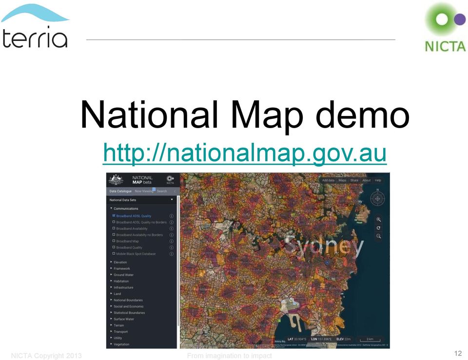
11 National Map: Current data services Federal Government Department of Communications Geoscience Australia Bureau of Meteorology Australian Bureau of Statistics Department of Environment Australian Taxation Office And more State governments All are either available on nationalmap.gov.au or in progress Local councils Data from many are available (via data.gov.au) More soon 11
 More soon 11")
12 National Map demo 12
13 3. TerriaJS software 13


 on")
14 Architecture: In-browser The Australian National Map We developed these TerriaJS: Data collection navigation/search Connects to services: OGC, ESRI, GME, etc Data loading: URL, drag & drop Data formats: Geojson, KML, CSV, etc Existing open source software Cesium: 3D map display WebGL support Leaflet: 2D map display Canvas support Browser (eg Chrome, Firefox, Internet Explorer, Safari) on desktop and mobile 14
 on")
15 TerriaJS Features Supports all major browsers (Chrome, Firefox, Safari, IE9 and later) 3D or 2D views (3D for Chrome, Firefox, Safari, IE 11) Open Geospatial Consortium (OGC) standards (WMS, WFS, etc) Interoperability with GIS back-end services (eg ESRI, MapInfo, Google Maps Engine, Geoserver, etc) Support for spreadsheet data (in CSV files) with points, region codes (such as postal codes, country codes, etc) Time-based data and time-based imagery User searching of data catalogues Integration with CKAN for automated access to open data catalogues User can add their own data sets by drag & drop on the browser Sharing of map views by or web Maps embeddable in websites 15

16 4. Applications using TerriaJS 16
 National")
 Global Risk From Map imagination (for to impact")
17 Customised federated maps Australian Renewable Energy Mapping Infrastructure (for Aust Govt) National Environmental Information Infrastructure (for Aust Govt) Global Risk From Map imagination (for to impact UNEPFI and PSI)
 Global Risk From Map imagination (for to impact")
18 Custom applications Groundwater monitoring (for South Australian Government) Groundwater assessment (for NSW Government)

19 5. The future of Terria 19

20 Terria Predictive spatial analytics For use on a TerriaJS maps Spatial detailing Spatial community discovery And much more 20

21 Terria services 1. Custom Terria maps Federated web-based spatial data exploration For countries, companies and others 2. Custom applications using Terria Experience in spatial data applications (especially environment, resources, energy) 3. Predictive spatial analytics using Terria Eg environment, resources, demography 21
22 terria.io Talk to us at booth 42 Hear more about our spatial analytics tomorrow: 3pm in Big Data Analytics session (Peter Leihn) 22
23 Extra slides 23
24 Third-party applications using TerriaJS 24
25 Example of third party innovation Propeller Aero (Sydney) UAV-based 3D model generation for surveying 25
26 Example of third party innovation Propeller Aero (Sydney) UAV-based 3D model generation for surveying 26
27 Example of third-party innovation Earthproject.io - global planning system Showing Ebola data 27
Data Visualization Using Web GIS Software
 Data Visualization Using Web GIS Software Tuomas Peltonen Radiation and Nuclear Safety Authority (STUK), Finland NKS NordDSS Workshop, Copenhagen, 1.-2.10.2009 RADIATION AND NUCLEAR SAFETY AUTHORITY Preface
Introduction to Geospatial Web Services
 Geospatial Web Services Introduction to Geospatial Web Services An introduction and inventory of geospatial web services and their importance to interoperability in the geospatial domain. vers. 20100604
Environment Canada Data Management Program. Paul Paciorek Corporate Services Branch May 7, 2014
 Environment Canada Data Management Program Paul Paciorek Corporate Services Branch May 7, 2014 EC Data Management Program (ECDMP) consists of 5 foundational, incremental projects which will implement
There are various ways to find data using the Hennepin County GIS Open Data site:
 Finding Data There are various ways to find data using the Hennepin County GIS Open Data site: Type in a subject or keyword in the search bar at the top of the page and press the Enter key or click the
National Geothermal Data System and Global Geosciences Data Integration
 National Geothermal Data System and Global Geosciences Data Integration Lee Allison, AZGS Stephen Richard, AZGS Arlene Anderson, US DOE David Cuyler, US DOE & Sandia Natl Lab NERC 2008 Outline Rational
ArcGIS Online School Locator
 ArcGIS Online School Locator G-Cloud Services RM 1557vi Service Definition Esri UK G-Cloud 6 Lot 3 SaaS Services Crown Commercial Service Acknowledgement Esri and ArcGIS are trademarks, registered trademarks,
Portal for ArcGIS. Satish Sankaran Robert Kircher
 Portal for ArcGIS Satish Sankaran Robert Kircher ArcGIS A Complete GIS Data Management Planning & Analysis Field Mobility Operational Awareness Constituent Engagement End to End Integration Collect, Organize,
Leveraging Cloud-Based Mapping Solutions
 Leveraging Cloud-Based Mapping Solutions GeoAlberta October 28, 2014 Laura Kerssens Safe Software Agenda To the Cloud Using Basic Services Cloud Applications Web Services Cloud-Hosted Databases Real-time
Sydney Ph: +61 2 8570 5050. Melbourne Ph: +61 3 8680 3250. Adelaide Ph: +61 8 8425 8050. LISAsoft. Bespoke Development
 Sydney Ph: +61 2 8570 5050 Melbourne Ph: +61 3 8680 3250 Adelaide Ph: +61 8 8425 8050 LISAsoft Bespoke Development August 2008 MER Program Data Access Consultancy Monitoring, Evaluation and Reporting
Geospatially Enabling the World: The Convergence of Geospatial and Architectural and Engineering Design
 Geospatially Enabling the World: The Convergence of Geospatial and Architectural and Engineering Design Geoff Zeiss Director of Technology Autodesk Map Middle East Dubai 2007 1 Overview Geospatial inflection
Centre for EcologicalNoosphere Studies NAS RA CENS
 SCOPES 2009-2012 Scientific Co-operation between Eastern Europe and Switzerland Accessing Armenian Environmental data through CENS Spatial Data Infrastructure Centre for EcologicalNoosphere Studies NAS
OPEN SOURCE SOFTWARE AND THE AUSTRALIAN GOVERNMENT
 OPEN SOURCE SOFTWARE AND THE AUSTRALIAN GOVERNMENT A key-note speech by Brian Catto (Director Governance and Policy Branch, Australian Government Information Management Office) at the Open Source Developers
ArcGIS Server Implementation HIGHS and lows
 ArcGIS Server Implementation HIGHS and lows GIS-T March 2011 Eric Abrams Iowa DOT Eric.abrams@dot.iowa.gov Agenda The Problem Timeline Future Discussion/Questions The Problem - 2006 How does Iowa DOT integrate
Google Enterprise Geospatial. Andrea Aymerich Head of Geo Enterprise Italy
 Google Enterprise Geospatial Andrea Aymerich Head of Geo Enterprise Italy Google Confidential 2011 Google Internet Traffic Growth Location is anywhere Worldwide smartphone and tablet shipment exceed PC
Advancing online delivery of Australian soil data and information
 Advancing online delivery of Australian soil data and information Peter Wilson CSIRO Manager, National Soil Information Coordinator, Australian Collaborative Land Evaluation Program May 2012 (V2.0) for
EXPLORING AND SHARING GEOSPATIAL INFORMATION THROUGH MYGDI EXPLORER
 EXPLORING AND SHARING GEOSPATIAL INFORMATION THROUGH MYGDI EXPLORER Subashini Panchanathan Malaysian Centre For Geospatial Data Infrastructure ( MaCGDI ) Ministry of National Resources and Environment
Part B Statement of Requirements and Specification. for. My Local Services Application
 Local Government Association of South Australia Part B Statement of Requirements and Specification for My Local Services Application Table of Contents 1. Introduction...4 2. Overview of Requirements...4
Enabling embedded maps
 Enabling embedded maps Case: National geoportal of Finland Antti Rainio National Land Survey of Finland Trends: Web Services, Mapping Mashup, Open Source, Open Data Decentralised data s Service interfaces
Oklahoma s Open Source Spatial Data Clearinghouse: OKMaps
 Oklahoma s Open Source Spatial Data Clearinghouse: OKMaps Presented by: Mike Sharp State Geographic Information Coordinator Oklahoma Office of Geographic Information MAGIC 2014 Symposium April 28-May1,
INTEROPERABLE IMAGE DATA ACCESS THROUGH ARCGIS SERVER
 INTEROPERABLE IMAGE DATA ACCESS THROUGH ARCGIS SERVER Qian Liu Environmental Systems Research Institute 380 New York Street Redlands, CA92373, U.S.A - qliu@esri.com KEY WORDS: OGC, Standard, Interoperability,
INTRODUCTION GAIA RESOURCES. Environmental Consultants Association (WA) DATA SOURCES INFORMATION MANAGEMENT DATA SOURCES DATA SOURCES
 DATA SOURCES INFORMATION MANAGEMENT DATA SOURCES DATA SOURCES") INTRODUCTION GAIA RESOURCES Environmental Consultants Association (WA) Practitioners Guide to Information Management Data Sources and Tools Information Management what is it? Data Sources available Tools
INTRODUCTION GAIA RESOURCES Environmental Consultants Association (WA) Practitioners Guide to Information Management Data Sources and Tools Information Management what is it? Data Sources available Tools
County of Los Angeles. Chief Information Office Preferred Technologies for Geographic Information Systems (GIS) September 2014
 September 2014") County of Los Angeles Chief Information Office Preferred Technologies for Geographic Information Systems (GIS) September 2014 CIO Preferred Technologies for GIS This document lists the preferred Geographic
County of Los Angeles Chief Information Office Preferred Technologies for Geographic Information Systems (GIS) September 2014 CIO Preferred Technologies for GIS This document lists the preferred Geographic
SuperGIS Server 3.2 Standard Edition Specification
 SuperGIS Server 3.2 Standard Edition Specification 20140826 Specification 1. All of the services support SOAP (Simple Object Access Protocol). 2. Use map file created by SuperGIS Desktop as map services
Web and Mobile GIS Applications Development
 Web and Mobile GIS Applications Development Presented by : Aamir Ali Manager Section Head (GIS Software Customization) Pakistan Space and Upper Atmosphere Research Commission (SUPARCO) Geographical Information
Vector Web Mapping Past, Present and Future. Jing Wang MRF Geosystems Corporation
 Vector Web Mapping Past, Present and Future Jing Wang MRF Geosystems Corporation Oct 27, 2014 Terms Raster and Vector [1] Cells and Pixel Geometrical primitives 2 Early 2000s From static to interactive
Chapter 6: Data Acquisition Methods, Procedures, and Issues
 Chapter 6: Data Acquisition Methods, Procedures, and Issues In this Exercise: Data Acquisition Downloading Geographic Data Accessing Data Via Web Map Service Using Data from a Text File or Spreadsheet
Visualize your World. Democratization i of Geographic Data
 Visualize your World Democratization i of Geographic Data Session Agenda Google GEO Solutions - More than just a Map Enabling our Government Customers- Examples Summary & Invite to Learn More About Google
2009 CAP Grant Kickoff USGS, Reston, VA May 21, 2009
 Leveraging GOS Map and Data Services for Search and Rescue Operations using NASA WorldWind Open Source 3D Visualization Platform Nadine Alameh, Ph.D. MobiLaps LLC 2009 CAP Grant Kickoff USGS, Reston, VA
Web 3D Service (W3DS) in Geoserver
 in Geoserver") Jorge Gustavo Rocha jgr@di.uminho.pt Nuno Carvalho Oliveira nmco51845@gmail.com VI Jornadas SIG Libre, Girona, March 23, 2012 1 Motivation and Introduction 2 3 4 5 Motivation Motivation and Introduction
Jorge Gustavo Rocha jgr@di.uminho.pt Nuno Carvalho Oliveira nmco51845@gmail.com VI Jornadas SIG Libre, Girona, March 23, 2012 1 Motivation and Introduction 2 3 4 5 Motivation Motivation and Introduction
Leveraging Geospatial Information Across the Enterprise: Bentley s Flexible Geospatial Approach
 Leveraging Geospatial Information Across the Enterprise: Bentley s Flexible Geospatial Approach A Bentley White Paper Gijsbert Noordam Senior Consultant, Geospatial Center of Excellence www.bentley.com
Cloud Computing and Government Services August 2013 Serdar Yümlü SAMPAŞ Information & Communication Systems
 eenviper White Paper #4 Cloud Computing and Government Services August 2013 Serdar Yümlü SAMPAŞ Information & Communication Systems 1 Executive Summary Cloud computing could revolutionise public services
Geo-Scale Data Visualization in a Web Browser. Patrick Cozzi pcozzi@agi.com
 Geo-Scale Data Visualization in a Web Browser Patrick Cozzi pcozzi@agi.com About Me Developer Lecturer Author Editor http://www.seas.upenn.edu/~pcozzi/ About Cesium A WebGL virtual globe and map engine
Don Bartley Technology Research. Open Source Activity at the Australian Bureau of Statistics
 Don Bartley Technology Research Open Source Activity at the Australian Bureau of Statistics Purpose Abstract: The ABS has been exploring possibilities/opportunities with open source products and approaches
Leveraging Geospatial Information Across the Enterprise: Bentley s Flexible Geospatial Approach
 Leveraging Geospatial Information Across the Enterprise: Bentley s Flexible Geospatial Approach A Bentley White Paper Gijsbert Noordam Product Manager Nicolas Loubier Senior Product Manager July 2012 www.bentley.com
GeoMedia Product Update. Title of Presentation. Lorilie Barteski October 15, 2008 Edmonton, AB
 Product Update Title of Presentation Lorilie Barteski Edmonton, AB Know the audience poll Existing /Pro users Version 6.1 Version 6.0 Version 5.2 or earlier Existing WebMap users Version 6.1 Version 6.0
GeoManitoba Spatial Data Infrastructure Update. Presented by: Jim Aberdeen Shawn Cruise
 GeoManitoba Spatial Data Infrastructure Update Presented by: Jim Aberdeen Shawn Cruise Organization Overview Manitoba Innovation Energy and Mines Business Transformation and Technology (BTT) Application
Cloud Solutions for HR
 Cloud Solutions for HR 99Recruitment 99Onboarding 99Performance 99Learning 99Course Builder 99Pre-Built Courses Integrated Talent Management Software Recruitment Attract, engage and select the world s
Cloud application for water resources modeling. Faculty of Computer Science, University Goce Delcev Shtip, Republic of Macedonia
 Cloud application for water resources modeling Assist. Prof. Dr. Blagoj Delipetrev 1, Assist. Prof. Dr. Marjan Delipetrev 2 1 Faculty of Computer Science, University Goce Delcev Shtip, Republic of Macedonia
CURSO Inspire INSPIRE. SPEAKER: Pablo Echamendi Lorente. JEUDI 23/ THURSDAY 23 rd W S V : G E O S P A T I A L D A T A A C C E S S
 CURSO Inspire JEUDI 23/ THURSDAY 23 rd SPEAKER: Pablo Echamendi Lorente WS 5 SCHEDULE WMS OVERVIEW ACTIONS OGC SPECIFICATIONS OTHER SERVICES OVERVIEW proposal: Member States shall establish and operate
OPEN STANDARD WEB SERVICES FOR VISUALISATION OF TIME SERIES DATA OF FLOOD MODELS
 OPEN STANDARD WEB SERVICES FOR VISUALISATION OF TIME SERIES DATA OF FLOOD MODELS Barend Köbben FRMRC RPA 7 Workshop visualisations and flow simulations as flood risk communication tools
Interoperable Solutions in Web-based Mapping
 ISPRS SIPT IGU UCI CIG ACSG Table of contents Table des matières Authors index Index des auteurs Search Recherches Exit Sortir Interoperable Solutions in Web-based Mapping Marta Wojnarowska and Bridget
Implementation of information system to respond to a nuclear emergency affecting agriculture and food products - Case of Morocco
 Centre National de l énergie des sciences et techniques nucléaires (CNESTEN-Morocco) Implementation of information system to respond to a nuclear emergency affecting agriculture and food products - Case
Integration of location based services for Field support in CRM systems
 Invited Contribution to GeoInformatics. Deadline September 15, 2001. Integration of location based services for Field support in CRM systems By P. Álvarez, J.A. Bañares, P.R. Muro-Medrano and F.J. Zarazaga
Support Portal User Guide. Version 3.0
 Support Portal User Guide Version 3.0 What is the Coldharbour Support Portal? The Coldharbour Support Portal is a new tool which allows our customers to create or update support requests via the Coldharbour
An Esri White Paper June 2011 ArcGIS for INSPIRE
 An Esri White Paper June 2011 ArcGIS for INSPIRE Esri, 380 New York St., Redlands, CA 92373-8100 USA TEL 909-793-2853 FAX 909-793-5953 E-MAIL info@esri.com WEB esri.com Copyright 2011 Esri All rights reserved.
Clinton County GIS Program
 Clinton County GIS Program The Clinton County GIS Program consists of several unique means of disseminating GIS and related data. Joe Merritt, County GIS Manager 1 Clinton County GIS Program 2 What? Google
Institute of Computational Modeling SB RAS
 Institute of Computational Modeling SB RAS ORGANIZATION OF ACCESS TO OBSERVATIONAL DATA USING WEB SERVICES FOR MONITORING SYSTEMS THE STATE OF THE ENVIRONMENT Kadochnikov Aleksey A. Russia, Krasnoyarsk
How To Help Your Gis System Work More Smoothly
 4th GML Relay 26 januari 2006 Frank Langelaan Agenda Intergraph & OGC Interoperability Webservices Data Interoperability & Application Interoperability Web Map Service Web Feature Service GML relay Intergraph
Open data. Noordzeedagen. Gerard van der Kolff
 Open data Noordzeedagen Gerard van der Kolff Data growth and -storage, what s new? Predicting the future is difficult... ...and mostly fails. The Digital Disruption has already happened Worlds largest
Securing ArcGIS Server Services: First Steps
 Federal GIS Conference February 9 10, 2015 Washington, DC Securing ArcGIS Server Services: First Steps Michael Sarhan Esri msarhan@esri.com Agenda Review Basic Security Workflow ArcGIS Server Roles and
Compatibility Testing for Mobile Apps and Websites
 Compatibility Testing for Mobile Apps and Websites by Michael Yudanin a topic from Mobile Testing course Next full course: This is a sample of class Mobile Testing: Manual and Automated QUEST 2016, Chicago,
Free GIS Sites and Software
 Free GIS Sites and Software Alex Robertson Saint Ignatius College, Athelstone alex.robertson@ignatius.sa.edu.au Web Manager Geography Teachers Association of South Australia AGTA GIS Conference, Launceston,
Version 3.0, April 16, 2012, updated for ArcGIS 10.0 Produced by the Geographic Information Network of Alaska http://www.gina.alaska.
 Using the AlaskaMapped Web Services in ESRI ArcGIS Version 3.0, April 16, 2012, updated for ArcGIS 10.0 Produced by the Geographic Information Network of Alaska http://www.gina.alaska.edu AlaskaMapped
Task AR-09-01a Progress and Contributions
 Doug Nebert, POC U.S. Geological Survey ddnebert@usgs.gov March 2010 Task AR-09-01a Progress and Contributions Background and scope for AR-09-01a This Task defines the minimum, common technical capabilities
INSPIRE in practice: Experiences with INSPIRE data and services
 INSPIRE in practice: Experiences with INSPIRE data and services Peter Parslow Principal Geographic Information Architect June 2014: ISO TC211 Standards in Practice workshop What s INSPIRE? European Commission
Easily add Maps and Geo Analytics in MicroStrategy
 Easily add Maps and Geo Analytics in MicroStrategy Agenda Introduction Configure to use Maps in MicroStrategy MicroStrategy Geo Analysis Capabilities and Examples Key Takeaways and Q&A Why Geospatial Analysis
SUBMISSION CASE STUDY ROUND 3 CHALLENGE 1 DIGITAL VIDEO & IMAGE LIBRARY
 SUBMISSION CASE STUDY ROUND 3 CHALLENGE 1 DIGITAL VIDEO & IMAGE LIBRARY PUBLIC IMAGE & VIDEO LIBRARY Public - Private Partners EXECUTIVE SUMMARY Challenge one of round three in the Digital Canberra Challenge
HUDSON SALARY GUIDES 2015
 Australia HUDSON SALARY GUIDES 2015 ICT about this publication This Salary Guide is a compilation of salary and market information provided by Hudson consultants, clients, candidates and other sources
Contents. The AARNet National Video Conferencing Service. QUESTnet 2008. Maggie Luczynska. National Video Conferencing Service.
 The AARNet National Video Conferencing Service Maggie Luczynska QUESTnet 2008 Gold Coast, July 9 th 2008 1 Contents National Video Conferencing Service NVCS Enhancements Quality Assurance Program - enabling
Product Comparison List
 Product Comparison List Data Center Size Site Solution / Feature
How To Use Gis
 Welcome Understanding Purpose Creating Relationships You A Global Community of GIS Professionals Changing the World Together Applying Geography Everywhere Your WORK Showcasing Your Web Apps Vision Applying
Remote Desktop Web Access. Using Remote Desktop Web Access
 Remote Desktop Web Access What is RD Web Access? RD Web Access is a Computer Science service that allows you to access department software and machines from your Windows or OS X computer, both on and off
Progress in Creating a Global Polar Metadata Interoperability Network
 Progress in Creating a Global Polar Metadata Interoperability Network Julie E. Friddell Canadian Cryospheric Information Network/Polar Data Catalogue Department of Geography, University of Waterloo Canada
Establishment of Spatial Data Infrastructure within the Environmental Sector in Slovak Republic
 EnviroInfo 2005 (Brno) Informatics for Environmental Protection - Networking Environmental Information Establishment of Spatial Data Infrastructure within the Environmental Sector in Slovak Republic Martin
From Geoportal to Spatial Data Service Platform. Jani Kylmäaho National Land Survey of Finland Development Centre
 From Geoportal to Spatial Data Service Platform Jani Kylmäaho National Land Survey of Finland Development Centre 29.6.2012 Introduction National Land Survey of Finland - 1900 employees Development Centre
Insight for location-powered decision making.
 Location Intelligence Geographic Information Systems MapInfo Pro Insight for location-powered decision making. Data drives our decisions every day. Blend this data with geography and you can visualise
ArcGIS. Server. A Complete and Integrated Server GIS
 ArcGIS Server A Complete and Integrated Server GIS ArcGIS Server A Complete and Integrated Server GIS ArcGIS Server enables you to distribute maps, models, and tools to others within your organization
Keystone Image Management System
 Image management solutions for satellite and airborne sensors Overview The Keystone Image Management System offers solutions that archive, catalogue, process and deliver digital images from a vast number
Advertising Rate Card FY 2016
 Advertising Rate Card FY 2016 Key Statistics FY 2015 18% Growth in site traffic 31% increase in site traffic over the last 2 years. (FY14: 13%) High growth rate reflects increasing number of consumers
smespire - Exercises for the Hands-on Training on INSPIRE Network Services April 2014 Jacxsens Paul SADL KU Leuven
 smespire - Exercises for the Hands-on Training on INSPIRE Network Services April 2014 Jacxsens Paul SADL KU Leuven These exercises aim at people who already have some basic knowledge of INSPIRE Network
Making MAGIC with Your Data: Interactive Maps, Map Mashups, and Data Visualization Tools
 Making MAGIC with Your Data: Interactive Maps, Map Mashups, and Data Visualization Tools Michael Howser Connecticut State Data Center Coordinator & Undergraduate Education & GIS Librarian What is the Connecticut
Correspondence can be sent to: GeoConnections Natural Resources Canada 615 Booth Street Ottawa, Ontario K1A 0E9
 Quick Guide for CGDI Service Compliance Testing and Performance Optimization May 12, 2009 Correspondence can be sent to: GeoConnections Natural Resources Canada 615 Booth Street Ottawa, Ontario K1A 0E9
Advances in the Application of Geographic Information Systems (GIS) Carmelle J. Terborgh, Ph.D. ESRI Federal/Global Affairs
 Carmelle J. Terborgh, Ph.D. ESRI Federal/Global Affairs") Advances in the Application of Geographic Information Systems (GIS) Carmelle J. Terborgh, Ph.D. ESRI Federal/Global Affairs Highlights GIS in our World Advancements in GIS Visualization and Analysis Geographic
Advances in the Application of Geographic Information Systems (GIS) Carmelle J. Terborgh, Ph.D. ESRI Federal/Global Affairs Highlights GIS in our World Advancements in GIS Visualization and Analysis Geographic
ArcGIS Framework Plug-In: Extending the ArcGIS Desktop for ANSI Standard Framework Data to Support Government Decision Making
 ArcGIS Framework Plug-In: Extending the ArcGIS Desktop for ANSI Standard Framework Data to Support Government Decision Making Final Project Report October 28, 2008 Agreement Number Organization Project
Lecture 8. Online GIS
 Lecture 8 Online GIS Lecture 8: Outline I. Online GIS 1. Google Earth 2. MSN Live Maps II. Open Source GIS III. ArcGIS Server and the ESRI suite of online software utility options IV. Advanced Data Mining
CentropeSTATISTICS a Tool for Cross-Border Data Presentation Manfred Schrenk, Clemens Beyer, Norbert Ströbinger
 Manfred Schrenk, Clemens Beyer, Norbert Ströbinger (Dipl.-Ing. Manfred Schrenk, Multimediaplan.at, 2320 Schwechat, Austria, schrenk@multimediaplan.at) (Dipl.-Ing. Clemens Beyer, CORP Competence Center
Sustainable Development for Smart Cities: A Geospatial Approach
 Middle East Geospatial Forum Dubai 16 th February 2015 Sustainable Development for Smart Cities: A Geospatial Approach Richard Budden Business Development Manager, Transportation and Infrastructure rbudden@esri.com,
Quality Assessment for Geographic Web Services. Pedro Medeiros (1)
") Quality Assessment for Geographic Web Services Pedro Medeiros (1) (1) IST / INESC-ID, Av. Prof. Dr. Aníbal Cavaco Silva, 2744-016 Porto Salvo, pmelo.medeiros@gmail.com Abstract Being able to assess the
Quality Assessment for Geographic Web Services Pedro Medeiros (1) (1) IST / INESC-ID, Av. Prof. Dr. Aníbal Cavaco Silva, 2744-016 Porto Salvo, pmelo.medeiros@gmail.com Abstract Being able to assess the
GEOSPATIAL SERVICE PLATFORM FOR EDUCATION AND RESEARCH
 GEOSPATIAL SERVICE PLATFORM FOR EDUCATION AND RESEARCH Jianya Gong, Huayi Wu, Wanshou Jiang, Wei Guo, Xi Zhai, Peng Yue State Key Laboratory of Information Engineering in Surveying, Mapping and Remote
Managing a Geographic Database From Mobile Devices Through OGC Web Services
 Managing a Geographic Database From Mobile Devices Through OGC Web Services Nieves R. Brisaboa 1, Miguel R. Luaces 1, Jose R. Parama 1, and Jose R. Viqueira 2 1 Database Laboratory, University of A Coruña,
ArcGIS Viewer for Silverlight An Introduction
 Esri International User Conference San Diego, California Technical Workshops July 26, 2012 ArcGIS Viewer for Silverlight An Introduction Rich Zwaap Agenda Background Product overview Getting started and
Microsoft Dynamics NAV 2015 Hardware and Server Requirements. Microsoft Dynamics NAV Windows Client Requirements
 Microsoft Dynamics NAV 2015 Hardware and Server Requirements Microsoft Dynamics NAV Windows Client Requirements Windows client. operating systems Hardware resources Reports Windows 8.1 Professional or
Vision. South Pacific GIS/RS Conference 2015 11/17/2015. Applying Geography Everywhere. Applying Geography Everywhere
 South Pacific GIS/RS Conference 2015 Applying Geography Everywhere Jithen (J) Singh Eagle Technology Group Ltd (Esri New Zealand) Suva, Fiji Vision Applying Geography Everywhere 1 GIS Is Evolving A Whole
AN INTEGRATED SOLUTION FOR MANAGING EXPLORATION DATA
 www.wipro.com AN INTEGRATED SOLUTION FOR MANAGING EXPLORATION DATA Sandipan Chakraborti, Senior Architect ENU Table of Contents 03... Introduction 04... Lack of Holistic View 06... Figure 1: Conceptual
HUDSON SALARY GUIDES 2015
 Australia HUDSON SALARY GUIDES 2015 Office Support about this publication This Salary Guide is a compilation of salary and market information provided by Hudson consultants, clients, candidates and other
AV-18 Introduction of the GIS Integration
 Slide 1 AV-18 Introduction of the GIS Integration Authors Victor Lough Dan Marsillo Geoff Tarcha social.invensys.com @InvensysOpsMgmt / #SoftwareRevolution /InvensysVideos /InvensysOpsMgmt /company/invensys
Towards a global statistical geospatial framework 1
 UNITED NATIONS SECRETARIAT ESA/STAT/AC.279/P3 Department of Economic and Social Affairs October 2013 Statistics Division English only United Nations Expert Group on the Integration of Statistical and Geospatial
Open Source Software and the Australian Government
 1 Open Source Software and the Australian Government Brian Catto Director, Governance and Policy Branch Australian Government Information Management Office Department of Finance and Deregulation 18 th
http://www.esri.com/bia
 ArcGIS for Tribal Transportation Management David Gadsden Federal Account Manager dgadsden@esri.com d d 1 David Gadsden GIS Background UW Geography (1995) Peace Corps Tanzania Environmental Social Science
Business Process Management meets Change Management
 10,000 + Projects 800 + Clients 26 + Years of Experience Business Process Management meets Change Management Agenda 1. Introduction 2. What is Business Process Management? 3. Change Management and Business
Mapping Mashup/Data Integration Development Resources Teaching with Google Earth and Google Ocean Stone Lab August 13, 2010
 Mapping Mashup/Data Integration Development Resources Teaching with Google Earth and Google Ocean Stone Lab August 13, 2010 David Hart GIS Specialist University of Wisconsin Sea Grant Institute Virtual
ishare in the Cloud Service Definition v5.0
 Service Definition v5.0 An overview of ishare in the Cloud ishare is an end to end Enterprise GIS for public sector comprising a spatial data warehouse, rich functionality browser based GIS including editing
Volunteer Software Feature Comparison
 Thank you for your interest in our Better software! This document has been prepared to list the functions of Better software and, if helpful, to assist you in comparing it to other software you might be
GeoNetwork, The Open Source Solution for the interoperable management of geospatial metadata
 GeoNetwork, The Open Source Solution for the interoperable management of geospatial metadata Ing. Emanuele Tajariol, GeoSolutions Ing. Simone Giannecchini, GeoSolutions GeoSolutions GeoSolutions GeoNetwork
Navigating Your Move to the Cloud
 Navigating Your Move to the Cloud With Microsoft having recently launched its two Australian data centres there s never been a better time to move your business to the cloud. However for some organisations,
Open Source Software and Open Interoperability Standards at EDINA National Datacentre
 Open Source Software and Open Interoperability Standards at EDINA National Datacentre Joe Vernon November 25, 2009 Slide 1 of 18 Overview of Presentation Introducing EDINA national datacentre Our thoughts
Step 1 Preparation and Planning
 Its daunting starting any GIS Web or Mobile project. Where does one begin? This 3 step guide should help you get past your project inertia and start things moving rapidly forward. Step 1 Preparation and
Evaluation Checklist Data Warehouse Automation
 Evaluation Checklist Data Warehouse Automation March 2016 General Principles Requirement Question Ajilius Response Primary Deliverable Is the primary deliverable of the project a data warehouse, or is
Cloud Solutions for HR
 Cloud Solutions for HR 99Recruitment 99Onboarding 99Performance 99Succession 99Learning 99Course Builder 99Pre-Built Courses Integrated Talent Management Software Recruitment Attract, engage and select
UK Location Programme
 Location Information Interoperability Board Data Publisher How To Guide Understand the background to establishing an INSPIRE View Service using GeoServer DOCUMENT CONTROL Change Summary Version Date Author/Editor