INFORM project overview and status
|
|
|
- Lindsay Wilkerson
- 8 years ago
- Views:
Transcription

1 INFORM project overview and status Ils Reusen, VITO Els Knaeps, VITO and the INFORM consortium

2 Improved monitoring and forecasting of ecological status of European INland waters by combining Future earth ObseRvation data and Models

3 Why focus on inland waters? Fishing, recreation, water supply, transport, waste disposal, irrigation, increased pressures on EU inland waters asks for sustainable water management Monitoring of inland water quality required by EU Water Framework Directive (2000/60/EC) EU Habitats Directive (92/43/EEC) EU Shellfish Waters Directive (2006/113/EC) EU Drinking Water Directive (98/83/EC) EU Bathing Water Directive (2006/7/EC) EU Nitrates Directive (91/676/EEC) EU Urban Waste Water... Environmental Impact Assessments (e.g. by dredging companies)
 EU Shellfish Waters Directive (2006/113/EC) EU Drinking Water Directive (98/83/EC) EU Bathing Water Directive (2006/7/EC) EU")
4 Blueprint to Safeguard Europe's Water Resources (COM/2012/673) mentions Copernicus THE STATUS OF EU WATERS IS NOT DOING WELL ENOUGH! The Water Information System (WISE) will benefit from the development of INSPIRE, SEIS and Copernicus and from current water research works under FP7 and those to be conducted under H2020

5 Copernicus Copernicus = The European Earth Observation Programme Copernicus services address six main thematic areas:» Land Monitoring (operational)» Marine Monitoring (pre-operational phase)» Atmosphere Monitoring (pre-operational phase)» Emergency Management (operational)» Security (development phase)» Climate Change (development phase) All are provided free of charge to users
 All are provided free of charge to users http://www.copernicus.eu")
6 White Paper Copernicus Inland Water Services Discussion document to extend Copernicus Land Monitoring Service portfolio with inland water services demonstrated in FP7 Space projects Proposed Copernicus inland water services» Irrigation Water Abstraction Monitoring and Control Service» Pan-European Inland Water Quality Monitoring Service» Water scarcity and drought monitoring and forecasting Services» Inland water quantity monitoring service

7 Earth Observation for monitoring inland waters? Today: underutilized complexity and variability of these inland waters lack of adequate analysis methods lack of adequate low-cost EO data lack of uncertainty estimates Report GEO inland and coastal Water Quality Algorithm Workshop, Washington DC, May 2009: There is a lack of appropriate/dedicated satellite sensors for nearshore coastal and inland water quality applications.

8 Earth Observation & biogeochemical models? Assimilation of EO products into biogeochemical models allows for analysis of the cause-effect relationships governing a status change, forecast the response to pressures and evaluate different management actions. the future lies in the combined utilization of in situ data, remote sensing, and modeling. Tiffany A.H. Moisan, Shubha Sathyendranath and Heather A. Bouman (2012). Ocean Color Remote Sensing of Phytoplankton Functional Types, Remote Sensing of Biomass - Principles and Applications, Temilola Fatoyinbo (Ed.), ISBN: , InTech, Available from:
. Ocean Color Remote Sensing of Phytoplankton Functional Types, Remote Sensing of Biomass - Principles and Applications, Temilola Fatoyinbo (Ed.")
9 EU FP7-SPACE project INFORM Collaborative project - THEME [SPA ] [Remote sensing methods] Start date: 1/1/2014 Duration: 48 months 9 beneficiaries from 7 EU Member States Requested EU contribution: Grant agreement n
![.1.1-07] [Remote sensing methods] Start date: 1/1/2014](/docs-images/46/396949/images/page_9.jpg "Duration: 48 months 9 beneficiaries from 7 EU Member States")
10 Main concept To develop novel user-driven products for inland water quality monitoring by using new innovative methods integrated into models which fully exploit the capabilities of upcoming Earth Observation missions (Sentinel-2, Sentinel-3, EnMAP and PRISMA)

11 Sentinel-2 Sentinel-2A launch readiness: 30 April 2015 Global revisit time: 5 days with 2 satellites MSI (Multi Spectral Instrument)» 13 spectral bands: 443 nm 2190 nm (including 3 bands for atmospheric corrections)» Spectral resolution: 15 nm 180 nm» Spatial resolution: 10 m, 20 m and 60 m» Swath: 290 km ESA P. Carrill

12

13 Sentinel-3 Sentinel-3A launch readiness: end of day global coverage OLCI (Ocean and Land Colour Instrument)» Swath width: 1270 km, with 5 tilted cameras» Spatial sampling: 300 m (full resolution mode)» Spectral range: 21 bands [ ] μm ESA PJ. Huart
» Spectral range: 21 bands [0.4-1.02] μm ESA PJ.")
14 Normalized OLCI SRFs, bands 1 to 21, plotted versus wavelength [nm] from C. Pelloquin, J. Nieke, SENTINEL-3 OLCI AND SLSTR SIMULATED SPECTRAL RESPONSE FUNCTIONS (S3-TN-ESA-PL-316) OLCI spectral bands = MERIS heritage+additional bands: Oa1 (400 nm): aerosol correction, improved water constituents retrieval Oa9 (673,75 nm): improved fluorescence retrieval and smile correction Oa14 (764,375 nm): atmospheric correction Oa15 (767,5 nm): cloud top pressure, fluorescence over land Oa20 (940 nm): water vapour absorption, atmospheric/aerosol correction Oa21 (1020 nm): atmospheric/aerosol correction
: atmospheric correction Oa15 (767,5 nm): cloud top pressure, fluorescence over land Oa20 (940 nm): water vapour absorption,")
15 EnMAP» Expected launch date: 2017» Hyperspectral» Spectral range from 420 nm to 1000 nm (89 VNIR bands-8.1 nm FWHM) and from 900 nm to 2450 nm (155 SWIR bands-12.5 nm FWHM)» Swath width 30 km» Spatial resolution of 30 m x 30 m» Off-nadir (30 ) pointing feature for fast target revisit (4 days)
» Swath width 30 km» Spatial resolution of 30 m x 30 m»")
16 PRISMA» Expected launch date: 2017» Hyperspectral» Spatial resolution: m (Hyp) / m (PAN)» Swath width: km» Spectral range: µm (Hyp) / µm (PAN)» Continuous coverage of spectral ranges with 10 nm bands
 / 0.4-0.")
17 APEX airborne hyperspectral imaging sensor for Simulation Calibration Validation of satellite sensors/products

18 INFORM consortium Participant organisation name VLAAMSE INSTELLING VOOR TECHNOLOGISCH ONDERZOEK N.V. CONSIGLIO NAZIONALE DELLE RICERCHE Participant short name Country VITO - Coordinator BELGIUM Ils Reusen, Els Knaeps, Sindy Sterckx, Liesbeth De Keukelaere, Dries Raymaekers, CNR ITALY Mariano Bresciani, Claudia Giardino, EOMAP GmbH & Co.KG EOMAP GERMANY Karin Schenk, Philip Klinger, Thomas Heege, THE UNIVERSITY OF STIRLING INSTITUT ROYAL DES SCIENCES NATURELLES DE BELGIQUE U STIRLING UK Peter Hunter, Andrew Tyler, Evangelos Spyrakos RBINS BELGIUM Dimitry Van der Zande, Kevin Ruddick, STICHTING DELTARES Deltares THE NETHERLANDS Miguel Dionisio Pires, PLYMOUTH MARINE LABORATORY MAGYAR TUDOMANYOS AKADEMIA OKOLOGIAI KUTATOKOZPONT KLAIPEDOS UNIVERSITETAS PML UK Giorgio Dall Olmo, Steve Groom + Stefan Simis, MTA OK HUNGARY Matyas Presing, KLAIPEDOS UNIVERSITETAS LITHUANIA Arturas Razinkovas- Baziukas,

19 INFORM Steering Advisory Board Members Tasks (SAB) Dr. Tiit Kutser, Remote Sensing and Marine Optics Department, Estonian Marine Institute, University of Tartu, Estonia Dr. Stewart Bernard, CSIR-NRE (Centre of High Performance Computing), South-Africa Dr. Vittorio Brando, CNR-IREA To provide recommendations at the SAB01 meeting (January 2014) To formulate scientific comments on the INFORM progress and to provide recommendations at SAB02 meeting (Mid-term, January 2016)
 To formulate scientific")
20 INFORM End-User Advisory Board Members (EUAB) Marc Sas/Boudewijn Decrop, International Marine and Dredging Consultants (IMDC), Belgium Marco Bartoli, Expert ecologist, University of Parma, Life Sciences Department Ute Menke, advisor Network Water, Rijkswaterstaat, the Netherlands István Kóbor head of laboratory, Central-Transdanubian Water Directorate, Hungary Geoff Phillips/Bill Brierley, Research, Monitoring and Innovation. Environmental Agency (EA) for England & Wales Alfred Johny Wüest, EAWAG, aquatic research institute, Switzerland Algirdas Stankevičius, Head of the Marine Research Department of the Ministry of Environment, Lithuania = COPERNICUS USER FORUM member Thomas Wolf, Environmental Agency of Baden-Wuerttemberg (LUBW), Germany Tasks To provide user requirements for INFORM developments at the EUAB01 (March 2014) and EUAB02 (Mid-term, January 2016) To attend the INFORM EUAB03 results uptake workshop (December 2017)
 for England & Wales Alfred Johny Wüest, EAWAG, aquatic research institute, Switzerland Algirdas Stankevičius, Head of the Marine Research Department of the Ministry of")
21 European approach Site Country Characteristic Lake Balaton Kis Balaton Hungary Largest shallow lake in Central Europe, meso-oligotrophic Water Protection System, hypereutrophic Curonian lagoon Lithuania Hypereutrophic coastal lagoon Lakes Mantua Italy Small and shallow artificial eutrophic basins Lagoon of Venice Italy Turbid coastal lagoon Lake Constance Germany, Meso-oligotrophic lake Switzerland, Austria Gironde river France Highly turbid river Scheldt river Belgium Highly turbid river Lake Windermere UK Mesotrophic lake Loch Lomond UK Warm, monomictic basin. Oligotrophic northern basin, mesotrophic southern basin Loch Leven UK polymictic, nonstratifying and eutrophic shallow lake Ijsselmeer The Netherlands Eutrophic lake, largest freshwater lake area in Northwestern Europe Markermeer is a turbid lake. +Lake Geneva, Switzerland
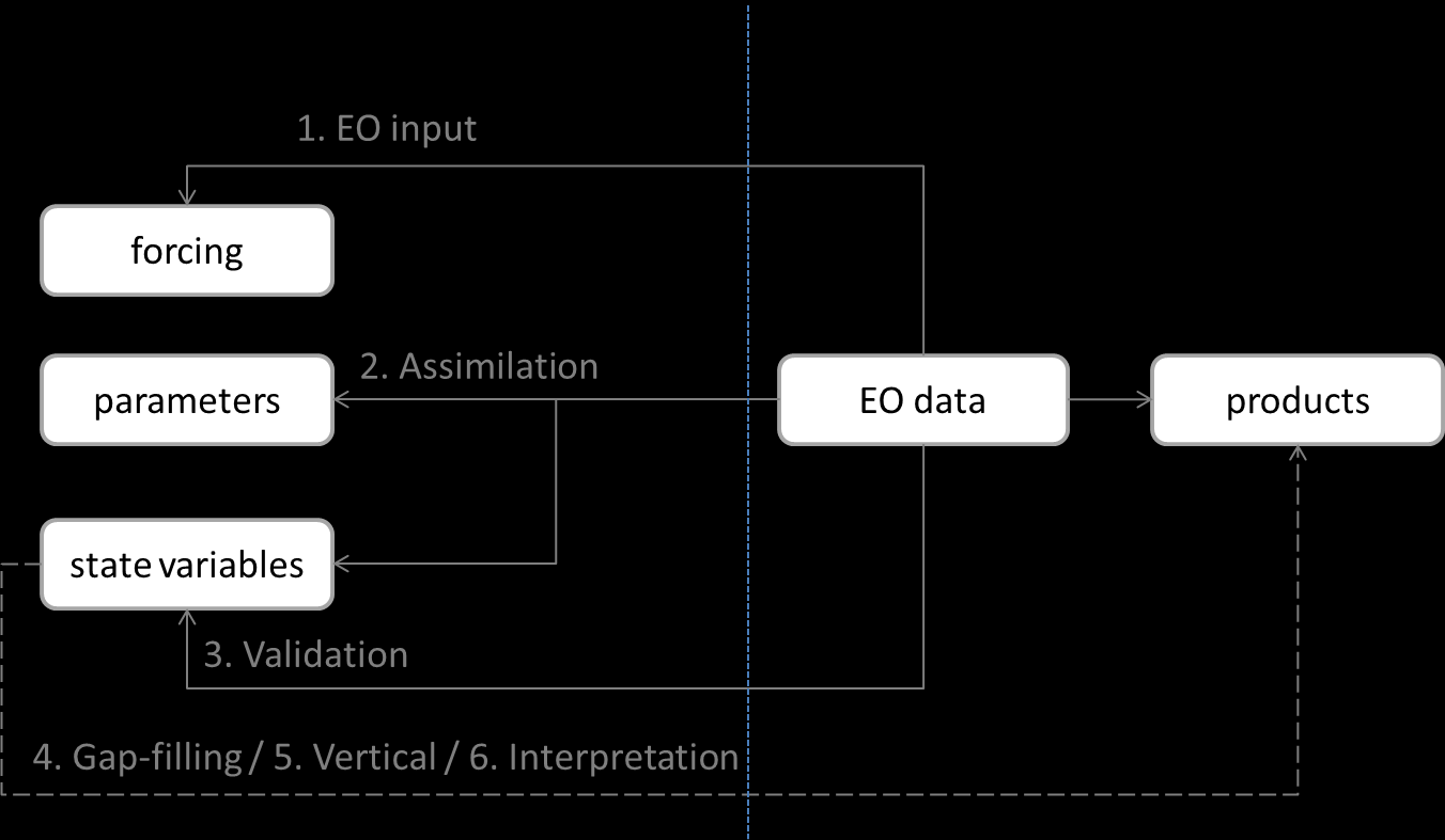
22 INFORM concept (detail) Properties of upcoming EO sensors (Sentinel-2, Sentinel-3, EnMAP, PRISMA) Improved spatial resolution Increased spectral coverage to shorter and longer wavelengths Improved spectral resolution Innovative analysis methods and improved atmospheric correction New/improved products Atttenuation and euphotic depth TSM and turbidity Yellow matter Phytoplanktion functional types Stratification Macrophytes Phytoplankton primary production Sun-induced chlorofyll fluorescence Improved modelling End-users End-users
23 WP objectives WP1 Management (VITO) Legal management Financial management Administrative management WP2 Scientific coordination (VITO) Scientific coordination of the project WP3 End-user interaction (CNR) To explore the end-user requirements in terms of water quality products To stimulate project results uptake by the end-users and industry WP4 Data gathering (VITO) To inventory existing data, identify data gaps To acquire new (in-situ, APEX hyperspectral and satellite) data» Development Campaign 2014» Testing Campaign 2016
24 WP objectives WP5 Algorithm development and validation (U STIRLING) Development and validation of EO products, and estimation of their uncertainty for WP6» Atmospheric correction (RBINS)» Attenuation and euphotic depth (RBINS)» TSM and turbidity (VITO)» Yellow matter (PML)» Phytoplankton functional types (CNR)» Stratification (EOMAP)» Macrophytes (CNR)» Phytoplankton primary production (U STIRLING)» Sun-induced chlorophyll fluorescence (U STIRLING)
25 WP objectives WP6 EO-model integration (Deltares) Integration of Earth Observation (EO) & In-Situ (IS) data and Water Quality (WQ) modelling WP7 Demonstration (EOMAP) To demonstrate to end-users» the INFORM prototype algorithms applied to new satellite sensors and» the added value of INFORM EO products for WQ model validation and forecasting To test the compliance of INFORM EO products with end-user requirements
26 WP objectives WP8 Dissemination (VITO) To disseminate the project objectives, progress and results To raise the awareness of the INFORM project To give recommendations for future satellite missions To organise a results uptake workshop
27 Interdependency of Work Packages
28 WP3: End-user interaction (Leader: CNR)
29 Kick-off end-user requirements EUAB end-user requirements formulated at the EUAB01 meeting, March 2014, Venice: General conclusion: the benefits that harmonized MULTI-TEMPORAL AND SPATIAL information derived from satellite images can give with respect to the traditional in-situ monitoring techniques based on point measurements was pointed out as the most important improvement compared to their current practices. In addition following requirements were formulated:» TEMPORAL AND SPATIAL RESOLUTION: Monthly temporal frequency of EO data, with a spatial resolution of 100 m. Exceptions are TSM, Turbidity and Chl-a maps which are required daily.
30 Kick-off end-user requirements» ACCURACY: Associated information about the quality of pixel values; robust algorithms with reference to literature or algorithm theoretical basis document (ATBD).» CONSISTENCY: Consistency between products derived from different sensors; a robust atmospheric correction with reference to literature or ATBD.» TAXONOMY: A standardized taxonomy (e.g. parameters names, measurement units, legend, color code) is received as a prerequisite for a harmonized EU-wide inland water quality monitoring.» ACCESSIBILITY: Easily accessible data and downloadable preferably by Web Map Service (WMS); training is requested.
31 WP4: Data gathering (Leader: VITO)
32 INFORM Development campaign - Balaton 2014 Lake Balaton and Kis Balaton wetland (Hungary) Data acquisition window: 7-28 July 2014 In-situ measurements (optical properties and water constituents) concurrent with satellite (Landsat8-OLI and HICO) and airborne hyperspectral (APEX) acquisitions


33 Balaton Balaton Limnological Institute Lake Balaton Kis Balaton Marcali Reservoir
34 Balaton - Characteristics Largest lake in central Europe Very shallow and well-mixed High mineral sediment loads (dolomitic mineralogy) Four distinct basins varying from mesotrophic to eutrophic Kis Balaton is hypertrophic Historically high nutrient loads but recent improvements in water quality Surface area 592 km 2 Catchment area 5772 km 2 Length 78 km Mean (max) width 9.1 (15) km Mean (max) depth 3.2 (11) m Water volume 1861 million m 3 Retention time Shoreline length 3-8 years 235 km
35 INFORM Development campaign - Balaton 2014 Quicklooks Landsat8-OLI acquisition Data available from the U.S. Geological Survey
36
37 INFORM Development campaign - Balaton 2014 Quicklooks HICO acquisition Collaboration with Evangelos Spyrakos, U STIRLING Data available from NRL The U.S. Naval Research Laboratory OSU Oregon State University
38 Lake Balaton Hungary Lake Balaton Hungary
39 INFORM Development campaign - Balaton 2014» APEX acquisitions and in-situ measurements»
40 INFORM Development campaign - Balaton 2014 Date EO Data acquisition In-situ sampling stations APEX Landsat-8 HICO USTIR CNR VITO ALL Comments 09/07/2014 X X /07/ /07/ Instrument inter-comparison + reference ground targets 16/07/2014 X 4 5 (+3 KB) Kis Balaton macrophyte measurements 17/07/2014 X APEX flights aborted 18/07/ /07/2014 X 4 4 (+2 KB) 10 X Kis Balaton macrophyte measurements + reference ground targets Water samples taken at 7 stations. Underway transects with radiometers 21/07/2014 X /07/ /07/2014 X X 6 6 TOTAL STATIONS SAMPLED
41 In-situ optics U STIRLING» Wetlabs AC-S: (size fractioned) spectral absorption and attenuation» Wetlabs Eco-BB3: spectral backscattering» CTD: temperature, salinity, depth» Trio Satlantic HYPEROCRs: subsurface irradiance reflectance» Trio Satlanctic HyperSAS and trio TriOS RAMSES: downwelling irradiance, skylight irradiance, total surface radiance for water-leaving reflectance» (in lab) TriOS OSCAR PSICAM: spectral absorption
42 In-situ optics CNR» Wetlabs AC-9 and Hobi Labs Hydroscat-6: spectral absorption and attenuation» Cyclops-6 fluorometers: phytoplankton pigments (Chla, PC, PE), CDOM fluorescence (+temperature and depth)» ASD FieldSpec FR and WISP-3: subsurface irradiance reflectance and remote sensing reflectance» ASD FieldSpec FR, Spectrascan, WISP-3: macrophytes reflectance VITO» ASD FieldSpec FR: remote sensing reflectance» WetLabs ECO-BB3: spectral backscattering
43 Water sample analysis Chla, PC, HPLC (pigments), particulate absorption (PABS) + flow cytometry TSM, CDOM, POC, DOC, phytoplankton cell counts Primary production Particle size distribution, mycosporine-like amino acids Macrophytes: dry weight biomass, pigment and nutrient analysis
44 Left: CIMEL CE318 - atmospheric measurements Middle: ASD FieldSpec FR - water reflectance measurements Right: Wetlabs AC-S, Wetlabs BB3, Wetlabs AC-9, Hobi Labs Hydroscat, Cyclops-6 fluorometers intercomparison of IOP measurements
45 Left: WetLabs AC-S and ECO-BB3 absorption and backscatter Middle: HYPERSAS and RAMSES downwelling irradiance, skylight radiance, total surface radiance Right: In-situ campaign leader Peter Hunter with Evangelos Spyrakos (U STIRLING)
46 Left: Filtering on the USTIR boat for pigments and particulate absorption. Middle: Filtering in the BLI lab for total suspended matter Right: Preparing samples in the BLI lab for dissolved organic carbon analysis
47 WP5: Algorithms development and validation (Leader: U STIRLING)
48 WP 5.1: Atmospheric correction Leader: RBINS Rationale Major source of uncertainity for EO products AC is very challenging for inland waters due e.g. to altitude, land adjacency and complex aerosols Objective To develop an atmospheric correction algorithm for Sentinel-2, Sentinel-3 and EnMAP/PRISMA for inland waters taking TOA radiance data and various auxiliary data as input and providing BOA water reflectance data as output
49 SIMEC adjacency correction Sterckx et al., RSE, in press
50 WP 5.2: Light attenuation & euphotic depth Leader: RBINS Rationale Key input for primary production and other ecological models Existing algorithms not suited to inland waters and need adaption to hyperspectral sensors Objective To develop/adapt algorithms for Sentinel-2, EnMAP/PRISMA and APEX taking water reflectance data as input and providing outputs for spectral and PAR diffuse attenuation coefficients (Kd, KdPAR) and euphotic depth (Ze)
51
52 WP 5.3: TSM & Turbidity Leader: VITO Rationale Key measure of water quality; cal/val of sediment transport and other ecosystem models Exploit new sensors, especially SWIR bands for high TSM Objective To develop/adapt algorithms for Sentinel-2, EnMAP/PRISMA and APEX taking water reflectance data as input and providing outputs for total suspended matter (TSM) concentration and turbidity (TUR).
53 Remote sensing reflectance 0.06 Varying Total Suspended matter concentration (mg/m3) [Credit: RBINS/VITO] Wavelength (nm)
54 [Credit: RBINS]
55 WP 5.4: Yellow matter Leader: PML Rationale YM = sum of absorption by CDOM and non-algal particles CDOM linked to DOC Major influence on short wavelength light availability Expoit new hyperspectral data products, including UV region Objective Develop and validate a UV-visible algorithm for yellow matter absorption that decomposes total absorption into pure water, pigments, and yellow substances
56 Dutch lakes data set Figure PML? + explanation Yellow matter absorption dominant but rarely isolated in UV-A region -> requires decomposition approach
57 WP 5.5: Phytoplankton functional types Leader: CNR Rationale Relative abundance of PFTs (or size classes) important to ecosystem function Some toxic bloom-forming species cyanobacteria pose risks to animal and human health also driver for WFD Objective To develop/adapt and validate algorithms for Sentinel-2, EnMAP/PRISMA and APEX taking water reflectance data and IOPs as input and providing outputs of Chla, secondary pigments, and size classes.

58 PE PC Chl-a [Credit: CNR]
59 PC in Esthwaite Water (UK) mapped using airborne AISA hyperspectral data [Hunter et al. 2010]
60 WP 5.6: Stratification Leader: EOMAP Rationale Lakes often have pronounced vertical gradients in dissolved and particulate material due to stratification Currently, methods provide no information on depth distribution Objective Feasibility study to derive information about vertical gradients of TSM using various satellite sensors.

61 MODIS 250m channels nm MODIS MODIS 500m channels nm MODIS 500 m channels look deeper than MODIS 250 m due to the incorporation of shorter wavelengths Shallow view 250m Applicable also to other sensors with different band combinations [Credit: EOMAP] Deep view 500m
62 WP 5.7: Macrophytes Leader: CNR Rationale Macrophytes fulfill important functional roles in lake ecosystems Biological quality element under EU WFD High spatial variability and coexistence of different species require high spatial resolution imagery Objective To develop/adapt classification approach for mapping different groups of macrophyte (emerged and submerged) and evaluate the biomass and health status by applications dedicated indices to aquatic vegetation based on specific endmembers collected in the field and wavelet analysis.
63 Mantua lake system, Water Adjusted Vegetation Index (WAVI) map derived from APEX data for September 2011 (left). Spectral response of different aquatic vegetation types and groups derived from APEX (right). (Villa et al., 2014). [Credit: CNR-IREA]

![INDICES [Credit: CNR-IREA]](/docs-images/20/396949/images/64-0.jpg "Multispectral peak of season")
64 MULTITEMPORAL ASSESSMENT OF MACROPHYTES USING AQUATIC VEGETATION INDICES [Credit: CNR-IREA] Multispectral peak of season Multitemporal WAVI series
65 WP 5.8: Primary production Leader: USTIRLING Rationale C-fixation by phytoplankton is a key contributor to lake ecosystem energetics Tightly coupled to meteorology, climate and the catchment Model developed for ocean waters, but not tested in lakes Objective To develop a prototype model for the estimation of phytoplankton primary production in lakes from EO data.
 Deep Sea Res.")
66 Empirical VGPM Wavelength resolved Tilstone et al. (2009) Deep Sea Res. 56:
67 WP 5.9: Chlorophyll fluorescence Leader: U STIRLING Rationale Estimation of chlorophyll is problematic in lakes at low concentrations, especially in presence of high CDOM Fluorescence signal at 681nm might provide more accurate chlorophyll estimates Variability in relationship with chlorophyll related to physiology (photocompensation) Objective To undertake an evaluation of algorithms for the retrieval of chlorophyll fluorescence and concentration in lakes and explore relations with phytoplankton physiology
68 Chlorophyll-a in the Great Lakes derived from SICF peak at 685 nm. [Gons et al 2008]
69 WP6: EO-model integration (Leader: Deltares)
70 Delft3D: tool for effect chain analyses Physical parameters Transports (SPM,..) Water quality Ecology Fish, Birds other user functions, etc.
71 General modelling approach Delft3D-FLOW Hydrodynamics Delft3D-SED Suspended particulate matter (SPM) Delft3D-WAQ Origin of water and residence time Delft3D-ECO (BLOOM) Nutrients and primary production model
72 BLOOM BLOOM is a multi-species phytoplankton model Competition between phytoplankton types is the guiding principle in BLOOM BLOOM selects the optimum composition based on the ratio of the net growth rate and the requirements for each environmental resource Trade-off principle between growth and requirement: Relatively high potential growth rates may compensate a relatively large requirement hence opportunistic species win when light is high, efficient species win when there is little light
73 EO-model integration
74 More information and news


75 Thank you For more information: Contact:


76 INFORM KO+SAB01 meeting, January 2014, VITO, Mol, Belgium INFORM EUAB01 meeting, March 2014, CNR, Venice, Italy
Update on EUMETSAT ocean colour services. Ewa J. Kwiatkowska
 Update on EUMETSAT ocean colour services Ewa J. Kwiatkowska 1 st International Ocean Colour Science meeting, 6 8 May, 2013 EUMETSAT space data provider for operational oceanography Operational data provider
DEVELOPMENT OF MERIS LAKE WATER ALGORITHMS: VALIDATION RESULTS FROM EUROPE
 DEVELOPMENT OF MERIS LAKE WATER ALGORITHMS: VALIDATION RESULTS FROM EUROPE Antonio Ruiz-Verdú (1) *, Sampsa Koponen (2), Thomas Heege (3), Roland Doerffer (4), Carsten Brockmann (5), Kari Kallio (6), Timo
Lake Monitoring in Wisconsin using Satellite Remote Sensing
 Lake Monitoring in Wisconsin using Satellite Remote Sensing D. Gurlin and S. Greb Wisconsin Department of Natural Resources 2015 Wisconsin Lakes Partnership Convention April 23 25, 2105 Holiday Inn Convention
REPORT ON EXISTING DATA AND DATA GAPS D4.1
 REPORT ON EXISTING DATA AND DATA GAPS D4.1 Reference: INFORM_D4.1_v1.0 Author(s): Peter HUNTER (U STIRLING), Evangelos SPYRAKOS (U STIRLING), Ils REUSEN (VITO), Els KNAEPS (VITO), Mariano BRESCIANI (CNR),
Bio-optical monitoring of coastal Baltic Sea waters from research to applications
 Bio-optical monitoring of coastal Baltic Sea waters from research to applications Susanne Kratzer Department of Systems Ecology, SU Suse@ecology.su.se Gerald Moore Petra Philipson Christian Vinterhav Therese
16 th IOCCG Committee annual meeting. Plymouth, UK 15 17 February 2011. mission: Present status and near future
 16 th IOCCG Committee annual meeting Plymouth, UK 15 17 February 2011 The Meteor 3M Mt satellite mission: Present status and near future plans MISSION AIMS Satellites of the series METEOR M M are purposed
The European Space Agency s Synthetic Aperture Radar Programme From Experiment to Service Provision
 The European Space Agency s Synthetic Aperture Radar Programme From Experiment to Service Provision Evert Attema ESA, Directorate of Earth Observation Programme! The idea of an independent European space
Proba-V: Earthwatch Mission as part of ESA s Earth Observation Programmes
 Proba-V: Earthwatch Mission as part of ESA s Earth Observation Programmes Antwerp 05.07.2013 Bianca Hoersch Proba-V Mission Manager Third Party Mission & Sentinel-2 Mission Manager Earth Observation Directorate,
Satellite Snow Monitoring Activities Project CRYOLAND
 Satellite Snow Monitoring Activities Project CRYOLAND Background material for participants to the Workshop on European Snow Monitoring Perspectives, Darmstadt, 4-5 December 2012. CryoLand provides Snow,
Integrating Environmental Optics into Multidisciplinary, Predictive Models of Ocean Dynamics
 DISTRIBUTION STATEMENT A. Approved for public release; distribution is unlimited. Integrating Environmental Optics into Multidisciplinary, Predictive Models of Ocean Dynamics John J. Cullen Department
Landsat Monitoring our Earth s Condition for over 40 years
 Landsat Monitoring our Earth s Condition for over 40 years Thomas Cecere Land Remote Sensing Program USGS ISPRS:Earth Observing Data and Tools for Health Studies Arlington, VA August 28, 2013 U.S. Department
IMAGINES_VALIDATIONSITESNETWORK ISSUE 1.00. EC Proposal Reference N FP7-311766. Name of lead partner for this deliverable: EOLAB
 Date Issued: 26.03.2014 Issue: I1.00 IMPLEMENTING MULTI-SCALE AGRICULTURAL INDICATORS EXPLOITING SENTINELS RECOMMENDATIONS FOR SETTING-UP A NETWORK OF SITES FOR THE VALIDATION OF COPERNICUS GLOBAL LAND
Remote sensing and GIS applications in coastal zone monitoring
 Remote sensing and GIS applications in coastal zone monitoring T. Alexandridis, C. Topaloglou, S. Monachou, G.Tsakoumis, A. Dimitrakos, D. Stavridou Lab of Remote Sensing and GIS School of Agriculture
The use of Earth Observation technology to support the implementation of the Ramsar Convention
 Wetlands: water, life, and culture 8th Meeting of the Conference of the Contracting Parties to the Convention on Wetlands (Ramsar, Iran, 1971) Valencia, Spain, 18-26 November 2002 COP8 DOC. 35 Information
Commercial satellite supported maritime and water monitoring services, and their co-existence with public space innitiatives
 Commercial satellite supported maritime and water monitoring services, and their co-existence with public space innitiatives Thomas Heege EOMAP GmbH & Co.KG Germany Singapore USA www.eomap.com Content
'Developments and benefits of hydrographic surveying using multispectral imagery in the coastal zone
 Abstract With the recent launch of enhanced high-resolution commercial satellites, available imagery has improved from four-bands to eight-band multispectral. Simultaneously developments in remote sensing
BIOLOGICAL MONITORING WITH THE WESTERN CANADIAN ODAS MARINE BUOY NETWORK
 BIOLOGICAL MONITORING WITH THE WESTERN CANADIAN ODAS MARINE BUOY NETWORK Jim Gower, Angelica Peña and Ann Gargett Institute of Ocean Sciences, P.O. Box 6, Sidney, BC, V8L 4B2 Tel: 2 363-68, Fax: 363-6746,
WATER BODY EXTRACTION FROM MULTI SPECTRAL IMAGE BY SPECTRAL PATTERN ANALYSIS
 WATER BODY EXTRACTION FROM MULTI SPECTRAL IMAGE BY SPECTRAL PATTERN ANALYSIS Nguyen Dinh Duong Department of Environmental Information Study and Analysis, Institute of Geography, 18 Hoang Quoc Viet Rd.,
4 Decades of Belgian Marine Monitoring. presented by Karien De Cauwer, RBINS, Belgian Marine Data Centre
 4 Decades of Belgian Marine Monitoring presented by Karien De Cauwer, RBINS, Belgian Marine Data Centre 47 th International Liege colloquium, Liège, 4-8 th May 2015 Uplifting historical data to today s
Present Status of Coastal Environmental Monitoring in Korean Waters. Using Remote Sensing Data
 Present Status of Coastal Environmental Monitoring in Korean Waters Using Remote Sensing Data Sang-Woo Kim, Young-Sang Suh National Fisheries Research & Development Institute #408-1, Shirang-ri, Gijang-up,
Integration of mobile automated monitoring systems with decision support tools for smart HAB management. VITO Jaap van Nes Göteborg, May 2015
 Integration of mobile automated monitoring systems with decision support tools for smart HAB management VITO Jaap van Nes Göteborg, May 2015 INDEX 1. Background VITO Belgium 2. HAB monitoring methods 3.
SPOT4 (Take5) Contribution of Sentinel-2 to coast management
 Contribution of Sentinel-2 to coast management") SPOT4 (Take5) Contribution of Sentinel-2 to coast management Take 5 User s Day 2/10/2013 CNES Toulouse V. Lafon A. Robinet L. Barillé D. Bru S. Capo C. Cerisier A. Dehouck D. Doxaran D. Ducrot P. Gernez
SPOT4 (Take5) Contribution of Sentinel-2 to coast management Take 5 User s Day 2/10/2013 CNES Toulouse V. Lafon A. Robinet L. Barillé D. Bru S. Capo C. Cerisier A. Dehouck D. Doxaran D. Ducrot P. Gernez
ENVIRONMENTAL MONITORING Vol. I - Remote Sensing (Satellite) System Technologies - Michael A. Okoye and Greg T. Koeln
 System Technologies - Michael A. Okoye and Greg T. Koeln") REMOTE SENSING (SATELLITE) SYSTEM TECHNOLOGIES Michael A. Okoye and Greg T. Earth Satellite Corporation, Rockville Maryland, USA Keywords: active microwave, advantages of satellite remote sensing, atmospheric
REMOTE SENSING (SATELLITE) SYSTEM TECHNOLOGIES Michael A. Okoye and Greg T. Earth Satellite Corporation, Rockville Maryland, USA Keywords: active microwave, advantages of satellite remote sensing, atmospheric
Spectral Response for DigitalGlobe Earth Imaging Instruments
 Spectral Response for DigitalGlobe Earth Imaging Instruments IKONOS The IKONOS satellite carries a high resolution panchromatic band covering most of the silicon response and four lower resolution spectral
Passive Remote Sensing of Clouds from Airborne Platforms
 Passive Remote Sensing of Clouds from Airborne Platforms Why airborne measurements? My instrument: the Solar Spectral Flux Radiometer (SSFR) Some spectrometry/radiometry basics How can we infer cloud properties
Developments toward a European Land Monitoring Framework. Geoff Smith. Seminar 2 nd December, 2015 Department of Geography, University of Cambridge
 Developments toward a European Land Monitoring Framework Geoff Smith Specto Natura Limited Enable clients to deliver useful, accurate and reliable environmental information from EO. Positioned at the interface
LIMNOLOGY, WATER QUALITY
 LIMNOLOGY, WATER QUALITY PA RANI ET E R S, AN D c 0 IV D IT I 0 N S AND ECOREGIONS Water Quality Parameters Nutrients are important parameters because phosphorous and nitrogen are major nutrients required
Meris Reflectance and Algal-2 validation at the North Sea
 Meris Reflectance and Algal-2 validation at the North Sea Steef W.M. Peters IVM, De Boelelaan 187, 181 HV Amsterdam, Netherlands (steef.peters at ivm.vu.nl) Abstract In this paper spectral reflectances
INVESTIGATION OF TOTAL SUSPENDED MATTER IN PORONG REGION USING AQUA-MODIS SATELLITE DATA AND NUMERICAL MODEL. e-mail : Bambang_sukresno@yahoo.
 INVESTIGATION OF TOTAL SUSPENDED MATTER IN PORONG REGION USING AQUA-MODIS SATELLITE DATA AND NUMERICAL MODEL Bambang Sukresno* 1, Bayu Priyono 2, Dedy Aan Zahrudin 3, Berny A Subki 4 1 Institute for Marine
The international Argo programme: a revolution for ocean and climate observations Pierre-Yves Le Traon*, Ifremer Coordinator NAOS Equipex Project
 The international Argo programme: a revolution for ocean and climate observations Pierre-Yves Le Traon*, Ifremer Coordinator NAOS Equipex Project * Acknowledgments: NAOS, French Argo, Euro-Argo/Argo international
APPLICATION OF TERRA/ASTER DATA ON AGRICULTURE LAND MAPPING. Genya SAITO*, Naoki ISHITSUKA*, Yoneharu MATANO**, and Masatane KATO***
 APPLICATION OF TERRA/ASTER DATA ON AGRICULTURE LAND MAPPING Genya SAITO*, Naoki ISHITSUKA*, Yoneharu MATANO**, and Masatane KATO*** *National Institute for Agro-Environmental Sciences 3-1-3 Kannondai Tsukuba
Hyperspectral Satellite Imaging Planning a Mission
 Hyperspectral Satellite Imaging Planning a Mission Victor Gardner University of Maryland 2007 AIAA Region 1 Mid-Atlantic Student Conference National Institute of Aerospace, Langley, VA Outline Objective
Satellite Remote Sensing of Volcanic Ash
 Marco Fulle www.stromboli.net Satellite Remote Sensing of Volcanic Ash Michael Pavolonis NOAA/NESDIS/STAR SCOPE Nowcasting 1 Meeting November 19 22, 2013 1 Outline Getty Images Volcanic ash satellite remote
II. Related Activities
 (1) Global Cloud Resolving Model Simulations toward Numerical Weather Forecasting in the Tropics (FY2005-2010) (2) Scale Interaction and Large-Scale Variation of the Ocean Circulation (FY2006-2011) (3)
INVESTIGA I+D+i 2013/2014
 INVESTIGA I+D+i 2013/2014 SPECIFIC GUIDELINES ON AEROSPACE OBSERVATION OF EARTH Text by D. Eduardo de Miguel October, 2013 Introducction Earth observation is the use of remote sensing techniques to better
How To Manage Water Resources
 NB: Unofficial translation; legally binding texts are those in Finnish and Swedish Ministry of the Environment, Finland Government Decree on Water Resources Management (1040/2006) Given in Helsinki on
DISMAR: Data Integration System for Marine Pollution and Water Quality
 DISMAR: Data Integration System for Marine Pollution and Water Quality T. Hamre a,, S. Sandven a, É. Ó Tuama b a Nansen Environmental and Remote Sensing Center, Thormøhlensgate 47, N-5006 Bergen, Norway
How To Help The European Space Program
 Available GOCE Products Brief overview of ESA EO Missions & Programmes Pierre-Philippe Mathieu, ESA-EOP SAGOMA KO Meeting, 24 Nov, Liege, Belgium ESA EO : Overall Framework CCI, STSE GMES EOMD Available
European Space Agency EO Missions. Ola Gråbak ESA Earth Observation Programmes Tromsø, 17 October 2012
 European Space Agency EO Missions Ola Gråbak ESA Earth Observation Programmes Tromsø, 17 October 2012 Europe and Space, A POLICY Article 189 of the Lisbon Treaty (2009) gives the European Union an explicit
Introduction to teledection
 Introduction to teledection Formation Sébastien Clerc, ACRI-ST sebastien.clerc@acri-st.fr ACRI-ST Earth Observation Actors and Markets 2 Earth Observation economic importance Earth Observation is one of
Sentinel-3 Marine Test Data Set processed at EUMETSAT
 Sentinel-3 Marine Test Data Set processed at EUMETSAT Doc.No. : EUM/TSS/TEN/15/822144 Issue : v2 e-signed Date : 15 December 2015 WBS/DBS : EUMETSAT Eumetsat-Allee 1, D-64295 Darmstadt, Germany Tel: +49
New challenges of water resources management: Title the future role of CHy
 New challenges of water resources management: Title the future role of CHy by Bruce Stewart* Karl Hofius in his article in this issue of the Bulletin entitled Evolving role of WMO in hydrology and water
Resolutions of Remote Sensing
 Resolutions of Remote Sensing 1. Spatial (what area and how detailed) 2. Spectral (what colors bands) 3. Temporal (time of day/season/year) 4. Radiometric (color depth) Spatial Resolution describes how
Hyperspectral Remote Sensing of Water Quality Parameters for Large Rivers in the Ohio River Basin
 Hyperspectral Remote Sensing of Water Quality Parameters for Large Rivers in the Ohio River Basin Naseer A. Shafique, Florence Fulk, Bradley C. Autrey, Joseph Flotemersch Abstract Optical indicators of
Evaluation of the Effect of Upper-Level Cirrus Clouds on Satellite Retrievals of Low-Level Cloud Droplet Effective Radius
 Evaluation of the Effect of Upper-Level Cirrus Clouds on Satellite Retrievals of Low-Level Cloud Droplet Effective Radius F.-L. Chang and Z. Li Earth System Science Interdisciplinary Center University
Introduction to protection goals, ecosystem services and roles of risk management and risk assessment. Lorraine Maltby
 Introduction to protection goals, ecosystem services and roles of risk management and risk assessment. Lorraine Maltby Problem formulation Risk assessment Risk management Robust and efficient environmental
Soil degradation monitoring by active and passive remote-sensing means: examples with two degradation processes
 Soil degradation monitoring by active and passive remote-sensing means: examples with two degradation processes Naftaly Goldshleger, *Eyal Ben-Dor,* *Ido Livne,* U. Basson***, and R.Ben-Binyamin*Vladimir
MONITORING BLUE-GREEN ALGAE IN THE IJSSELMEER USING REMOTE SENSING AND IN-SITU MEASUREMENTS
 MONITORING BLUE-GREEN ALGAE IN THE IJSSELMEER USING REMOTE SENSING AND IN-SITU MEASUREMENTS MARY CHAWIRA February, 2012 SUPERVISORS: Dr. Ir. Mhd. Suhyb Salama Dr. Ir Rogier van der Velde MONITORING BLUE-GREEN
GLACier-fed rivers, HYDRoECOlogy and climate change; NETwork of monitoring sites (GLAC-HYDRECO-NET).
.") Arctic Observing Summit 2013 Statement Glacier-fed rivers GLACier-fed rivers, HYDRoECOlogy and climate change; NETwork of monitoring sites (GLAC-HYDRECO-NET). Alexander Milner, School of Geography, Earth
Arctic Observing Summit 2013 Statement Glacier-fed rivers GLACier-fed rivers, HYDRoECOlogy and climate change; NETwork of monitoring sites (GLAC-HYDRECO-NET). Alexander Milner, School of Geography, Earth
CORAL REEF HABITAT MAPPING USING MERIS: CAN MERIS DETECT CORAL BLEACHING?
 CORAL REEF HABITAT MAPPING USING MERIS: CAN MERIS DETECT CORAL BLEACHING? Arnold G. Dekker, Magnus Wettle, Vittorio E. Brando CSIRO Land & Water, P.O. Box 1666, Canberra, ACT, Australia ABSTRACT/RESUME
SLSTR Breakout Summary - Gary Corlett (22/03/2012)
") SLSTR Breakout Summary - Gary Corlett (22/03/2012) [Updated 16/04/2012 with post meeting comments from Gorm Dybkjær, Simon hook and David Meldrum] The breakout session started with a clean slate and identified
SLSTR Breakout Summary - Gary Corlett (22/03/2012) [Updated 16/04/2012 with post meeting comments from Gorm Dybkjær, Simon hook and David Meldrum] The breakout session started with a clean slate and identified
Integrated Global Carbon Observations. Beverly Law Prof. Global Change Forest Science Science Chair, AmeriFlux Network Oregon State University
 Integrated Global Carbon Observations Beverly Law Prof. Global Change Forest Science Science Chair, AmeriFlux Network Oregon State University Total Anthropogenic Emissions 2008 Total Anthropogenic CO 2
Joint Polar Satellite System (JPSS)
") Joint Polar Satellite System (JPSS) John Furgerson, User Liaison Joint Polar Satellite System National Environmental Satellite, Data, and Information Service National Oceanic and Atmospheric Administration
Joint Polar Satellite System (JPSS) John Furgerson, User Liaison Joint Polar Satellite System National Environmental Satellite, Data, and Information Service National Oceanic and Atmospheric Administration
China Earth Observation
 China High-resolution Earth Observation China Earth Observation System (CHEOS) and its Lastest Development The Earth Observation System and Data Center, CNSA 2014-2 Outlines 1 Introduction 2 The composition
ESA Climate Change Initiative contributing to the Global Space-based Architecture for Climate Monitoring
 ESA Climate Change Initiative contributing to the Global Space-based Architecture for Climate Monitoring Pascal Lecomte Head of the ESA Climate Office ESA/ECSAT Global Space-based Architecture for Climate
Chesapeake Bay and Potomac Tidal Monitoring Programs Past, Present and Future
 Chesapeake Bay and Potomac Tidal Monitoring Programs Past, Present and Future Bruce Michael Resource Assessment Service Maryland Department of Natural Resources The Future of Water Quality Monitoring in
European Gravity Service for Improved Emergency Management
 European Gravity Service for Improved Emergency Management a new Horizon2020 project to serve the international community and improve the accessibility to gravity field products A. Jäggi 1, M. Weigelt
The Copernicus Marine Enviroment Monitoring Service
 The Copernicus Marine Enviroment Monitoring Service P.Y. Le Traon 7&8 Sep 2015 - CMEMS SE & UU Workshop, Brussels 1 CMEMS : The Copernicus Marine Environment Monitoring Service SATELLITES (S1, S3, Jason-CS)
Data Management Framework for the North American Carbon Program
 Data Management Framework for the North American Carbon Program Bob Cook, Peter Thornton, and the Steering Committee Image courtesy of NASA/GSFC NACP Data Management Planning Workshop New Orleans, LA January
2.3 Spatial Resolution, Pixel Size, and Scale
 Section 2.3 Spatial Resolution, Pixel Size, and Scale Page 39 2.3 Spatial Resolution, Pixel Size, and Scale For some remote sensing instruments, the distance between the target being imaged and the platform,
SNOWTOOLS RESEARCH AND DEVELOPMENT OF REMOTE SENSING METHODS FOR SNOW HYDROLOGY
 SNOWTOOLS RESEARCH AND DEVELOPMENT OF REMOTE SENSING METHODS FOR SNOW HYDROLOGY Tore Guneriussen 1, Rune Solberg 2, Sjur Kolberg 3, Martti Hallikainen 4, Jarkko Koskinen 4, Daniel Hiltbrunner 5, Christian
Description of the table of the in-situ data requirements of GMES services
 Description of the table of the in-situ data requirements of GMES services 1. In-situ data requirement: Contains short description of each in-situ data (including spatial data) requirement defined by GMES
Report EU BASIN Kickoff Meeting, Copenhagen, Denmark
 Report EU BASIN Kickoff Meeting, Copenhagen, Denmark February 22 25, 2011, Meng Zhou Table of Contents Summary... 1 1. Highlights... 2 1) EU BASIN cruises... 2 2) Regional comparative studies and end to
Atmospheric correction of SeaWiFS imagery for turbid coastal and inland waters
 Atmospheric correction of SeaWiFS imagery for turbid coastal and inland waters Kevin George Ruddick, Fabrice Ovidio, and Machteld Rijkeboer The standard SeaWiFS atmospheric correction algorithm, designed
How To Measure Solar Spectral Irradiance
 Accurate Determination of the TOA Solar Spectral NIR Irradiance Using a Primary Standard Source and the Bouguer-Langley Technique. D. Bolsée, N. Pereira, W. Decuyper, D. Gillotay, H. Yu Belgian Institute
First WISER deliverables available
 December 2009 WISER PROJECT NEWSLETTER 02 First WISER deliverables available Deliverable D3.2-1 Overview and comparison of macrophyte survey methods used in European countries and a proposal for a harmonised
Origins and causes of river basin sediment degradation and available remediation and mitigation options. Feedback from the Riskbase workshop
 Origins and causes of river basin sediment degradation and available remediation and mitigation options Feedback from the Riskbase workshop Corinne Merly 1, Olivier Cerdan 1, Laurence Gourcy 1 Emmanuelle
Bathing water results 2008 Italy
 Bathing water results 2008 Italy 1. Introduction This report gives a general overview of water quality in Italy during the 2008 season. Italy reported 12 parameters under the Directive 76/160/EEC (1 Total
European Gravity Service for Improved Emergency Management
 European Gravity Service for Improved Emergency Management a new Horizon2020 project to serve the international community and improve the accessibility to gravity field products A. Jäggi 1, M. Weigelt
Emergency Management Service. early warning FLOOD AND FIRE ALERTS. Space
 Emergency Management Service early warning FLOOD AND FIRE ALERTS Space 1 Copernicus at a Glance Copernicus is the European Union s Earth Observation programme: a user-driven space programme under civil
Appendix B: Cost Estimates
 Appendix B: Estimates This appendix presents the estimated costs of the monitoring and supplemental research components presented in Section 3 of this document. A 20% quality assurance and quality control
Towards agreed data quality layers for airborne hyperspectral imagery
 Towards agreed data quality layers for airborne hyperspectral imagery M. Bachmann, DLR M. Bachmann, DLR, S. Adar, TAU; E. Ben-Dor, TAU; J. Biesemans, VITO; X. Briottet, ONERA; M. Grant, PML; J. Hanus,
Basin Management to Protect Ecosystem Health - Lessons from Estonia- Russian Cooperation
 Basin Management to Protect Ecosystem Health - Lessons from Estonia- Russian Cooperation Harry Liiv, Member of the Estonian-Russian Transboundary Water Commission General overview Estonia borders with
Big Data Challenge: Mining Heterogeneous Data. Prof. Mihai Datcu. German Aerospace Center (DLR) Munich Aerospace Faculty
 Munich Aerospace Faculty") Big Data Challenge: Mining Heterogeneous Data Prof. Mihai Datcu German Aerospace Center (DLR) Munich Aerospace Faculty Sensing & Big Data Big Data: - Computer hardware and the Cloud - Storage Challenges
Big Data Challenge: Mining Heterogeneous Data Prof. Mihai Datcu German Aerospace Center (DLR) Munich Aerospace Faculty Sensing & Big Data Big Data: - Computer hardware and the Cloud - Storage Challenges
Instrumentation for Monitoring around Marine Renewable Energy Devices
 Instrumentation for Monitoring around Marine Renewable Energy Devices 1 Introduction As marine renewable energy has developed, a set of consistent challenges has emerged following attempts to understand
Data Processing Flow Chart
 Legend Start V1 V2 V3 Completed Version 2 Completion date Data Processing Flow Chart Data: Download a) AVHRR: 1981-1999 b) MODIS:2000-2010 c) SPOT : 1998-2002 No Progressing Started Did not start 03/12/12
Monitoring Soil Moisture from Space. Dr. Heather McNairn Science and Technology Branch Agriculture and Agri-Food Canada heather.mcnairn@agr.gc.
 Monitoring Soil Moisture from Space Dr. Heather McNairn Science and Technology Branch Agriculture and Agri-Food Canada heather.mcnairn@agr.gc.ca What is Remote Sensing? Scientists turn the raw data collected
Data Processing Developments at DFD/DLR. Stefanie Holzwarth Martin Bachmann, Rudolf Richter, Martin Habermeyer, Derek Rogge
 Data Processing Developments at DFD/DLR Stefanie Holzwarth Martin Bachmann, Rudolf Richter, Martin Habermeyer, Derek Rogge EUFAR Joint Expert Working Group Meeting Edinburgh, April 14th 2011 Conclusions
Detecting the 2006 coral bleaching event at Keppel Isles using MERIS FR data: a feasibility study
 Detecting the 2006 coral bleaching event at Keppel Isles using MERIS FR data: a feasibility study Prepared for the Great Barrier Reef Marine Park Authority by M Wettle, A G Dekker, and D Blondeau-Patissier
Automatic land-cover map production of agricultural areas using supervised classification of SPOT4(Take5) and Landsat-8 image time series.
 and Landsat-8 image time series.") Automatic land-cover map production of agricultural areas using supervised classification of SPOT4(Take5) and Landsat-8 image time series. Jordi Inglada 2014/11/18 SPOT4/Take5 User Workshop 2014/11/18
Automatic land-cover map production of agricultural areas using supervised classification of SPOT4(Take5) and Landsat-8 image time series. Jordi Inglada 2014/11/18 SPOT4/Take5 User Workshop 2014/11/18
Saharan Dust Aerosols Detection Over the Region of Puerto Rico
 1 Saharan Dust Aerosols Detection Over the Region of Puerto Rico ARLENYS RAMÍREZ University of Puerto Rico at Mayagüez, P.R., 00683. Email:arlenys.ramirez@upr.edu ABSTRACT. Every year during the months
Report to 8 th session of OOPC. By Dr. Alan R. Thomas, Director, GCOS Secretariat
 Report to 8 th session of OOPC By Dr. Alan R. Thomas, Director, GCOS Secretariat The GCOS is comprised of the climate components of the domain based observing systems including both satellite and in situ
Cloud detection and clearing for the MOPITT instrument
 Cloud detection and clearing for the MOPITT instrument Juying Warner, John Gille, David P. Edwards and Paul Bailey National Center for Atmospheric Research, Boulder, Colorado ABSTRACT The Measurement Of
Overview of the involvement of local Research. Organisations, Enterprises, Universities in. national and international projects on Earth
 Overview of the involvement of local Research Organisations, Enterprises, Universities in national and international projects on Earth Observation applications and services. ( Earth Observation, Satellite
From Whitehall to orbit and back again: using space in government
 From Whitehall to orbit and back again: using space in government 18 th June 2014 Bristol 25 th June 2014 Liverpool 3 rd July 2014 -Newcastle Space for Smarter Government Programme (ssgp@sa.catapult.org.uk)
AN INTERCOMPARISON OF ANALYTICAL INVERSION APPROACHES TO RETRIEVE WATER QUALITY FOR TWO DISTINCT INLAND WATERS
 AN INTERCOMPARISON OF ANALYTICAL INVERSION APPROACHES TO RETRIEVE WATER QUALITY FOR TWO DISTINCT INLAND WATERS Knaeps 1 E. Raymaekers 1 D. Sterck 1 S. Odermatt 2 D. (1 VITO Flemish Institute or Technological
The Role of GARNET-E in supporting Disaster Management and Emergency Response for Africa
 The Role of GARNET-E in supporting Disaster Management and Emergency Response for Africa Presented by Prof. Isi Ikhuoria Regional Centre for Training in Aerial Surveys (RECTAS), Nigeria at The 9 th EUMETSAT
THE GOCI INSTRUMENT ON COMS MISSION THE FIRST GEOSTATIONARY OCEAN COLOR IMAGER
 THE GOCI INSTRUMENT ON COMS MISSION THE FIRST GEOSTATIONARY OCEAN COLOR IMAGER Topic 1 - Optical instruments for Earth / Planets surface and atmosphere study François FAURE, Astrium SAS Satellite, Toulouse,
Forest Fire Information System (EFFIS): Rapid Damage Assessment
: Rapid Damage Assessment") Forest Fire Information System (EFFIS): Fire Danger D Rating Rapid Damage Assessment G. Amatulli, A. Camia, P. Barbosa, J. San-Miguel-Ayanz OUTLINE 1. Introduction: what is the JRC 2. What is EFFIS 3.
Forest Fire Information System (EFFIS): Fire Danger D Rating Rapid Damage Assessment G. Amatulli, A. Camia, P. Barbosa, J. San-Miguel-Ayanz OUTLINE 1. Introduction: what is the JRC 2. What is EFFIS 3.
Broken Arrow Public Schools AP Environmental Science Objectives Revised 11-19-08
 1 st six weeks 1 Identify questions and problems that can be answered through scientific investigation. 2 Design and conduct scientific investigations to answer questions about the world by creating hypotheses;
UK ENVIRONMENTAL STANDARDS AND CONDITIONS (PHASE 1) Final report. April 2008
 Final report. April 2008") UK Technical Advisory Group on the Water Framework Directive UK ENVIRONMENTAL STANDARDS AND CONDITIONS (PHASE 1) Final report April 2008 (SR1 2006) Final Table of Contents LIST OF TABLES...3 SECTION 1
UK Technical Advisory Group on the Water Framework Directive UK ENVIRONMENTAL STANDARDS AND CONDITIONS (PHASE 1) Final report April 2008 (SR1 2006) Final Table of Contents LIST OF TABLES...3 SECTION 1
 Preface The term algal bloom is used to describe the temporal and spatial accumulation of phytoplankton in general or a single species in an aquatic environment. The phenomenon of water discoloration produced
gebruiken voor aardse toepassingen
 26/03/2014 Satellietgegevens gebruiken voor aardse toepassingen Dirk Van Speybroeck dirk.vanspeybroeck@vito.be VITO, VIsion on TechnOlogy» een op Europees vlak toonaangevend, onafhankelijk onderzoeks-
Aquatic Biomes, Continued
 Aquatic Biomes, Continued Introduction Extent of Marine biomes Issues & challenges Factors influencing distribution Dynamics in time & space Depth Tour of marine biomes Issues (by biome) Freshwater biomes
Delivering multiple benefits through effective river restoration UK & EU
 Martin Janes Managing Director The River Restoration Centre Delivering multiple benefits through effective river restoration UK & EU CIEEM Annual Conference Southampton 2013 rrc@therrc.co.uk 01234 752979
Automated In-Situ Water Quality Monitoring Report
 Automated In-Situ Water Quality Monitoring Report Issued by the North of Ireland Joint Agency Coastal Monitoring Programme. For further information and data access please visit our website at: www.afbini.gov.uk/coastal-monitoring.htm
Sediment and Dredged Material Management - Relevance and Objectives 18 September 2003
 - Relevance and Objectives 1. Scope of the Dutch German Exchange (DGE) The Netherlands and Germany have large river systems such as Danube, Rhine, Meuse, Elbe, Weser and Ems, which have important hydrological
Long-term Marine Monitoring in Willapa Bay. WA State Department of Ecology Marine Monitoring Program
 Long-term Marine Monitoring in Willapa Bay WA State Department of Ecology Marine Monitoring Program Ecology s Marine Waters Monitoring Program Goal: establish and maintain baseline environmental data Characterize
SEA TECHNOLOGY. Copernicus Downstream Service Supports Nature-Based Flood Defense. Use of Sentinel Earth Observation Satellites for Coastal Needs
 REPRINT SEA TECHNOLOGY WORLDWIDE INFORMATION LEADER FOR MARINE BUSINESS, SCIENCE & ENGINEERING Copernicus Downstream Service Supports Nature-Based Flood Defense Use of Sentinel Earth Observation Satellites