Paul S. Chang, Zorana Jelenak, Seubson Soisuvarn Faozi Said NOAA/NESDIS/STAR. Many thanks to the JPL/NASA RapidScat Team
|
|
|
- Milo Malone
- 8 years ago
- Views:
Transcription
1 Paul S. Chang, Zorana Jelenak, Seubson Soisuvarn Faozi Said NOAA/NESDIS/STAR Many thanks to the JPL/NASA RapidScat Team

2 ² Launch: September 21, 2014 on a SpaceX Dragon spacecral. ² Mission dura=on: 2 years. May extend if Columbus ISS site remains available. ² Instrument: Dual- polarizaron, Ku- band pencil beam scaterometer using engineering hardware from the QuikSCAT mission. ² Measurement accuracy: QuikSCAT- level accuracy with 25 and 12.5 km sparal resoluron. ² Measurement swath: ~800 km (varies with ISS alrtude) ² Data products: near real- Rme (NRT) data produced by JPL and distributed by STAR for NOAA s operaronal users, science data distributed through NASA s Physical Oceanography Data AcRve Archive Center (PODAAC). ² Mission =meline: the instrument was assembled largely from QuikSCAT and new parts, integrated and tested in less than 2 years,
 ² Data products: near real- Rme (NRT) data produced by JPL and distributed by STAR for NOAA s operaronal users, science data")
3 ² Data of opportunity Ø Wind products produced by JPL and distributed to NOAA operaronal users via NESDIS/STAR ² Daily RapidSCAT NRT wind maps available at htp://manar.star.nesdis.noaa.gov/datasets/rscatdata.php/ RSCATData.php Ø To gain access to NRT data ² NAWIPS RapidScat- lite files containing selected wind vectors in form of QuikScat like 25km and 12.5km liite files Ø Ambiguity lite files available soon

4 ² RapidScat publicly available in NRT via NESDIS/STAR Ocean Winds ManaR web page since Dec 1 st 2014 Global images and zoomed in images of selected winds Zoomed in images of all ambiguires Tropical Storm centered wind vector retrievals Tb and u and v- wind component monitoring pages Alerts to RapidScat scheduled outages htp://manar.star.nesdis.noaa.gov/datasets/rscatdata.php

5 NOAA NWS Ocean PredicRon Center A major accomplishment at the Ocean PredicRon Center and a huge boon for marine forecasrng: as of this morning, November 20th, we are now receiving experimental data from the RapidScat instrument flying aboard the InternaRonal Space StaRon! Similar to ASCAT, OSCAT and QuikSCAT, RapidScat will provide remotely sensed ocean surface wind speeds and direcrons. With such a huge void of radar and surface observarons over the oceans, remotely sensed ocean surface winds play an instrumental role in marine decision making, forecasrng, and modeling. For more informaron: htp:// rapidscat/

6

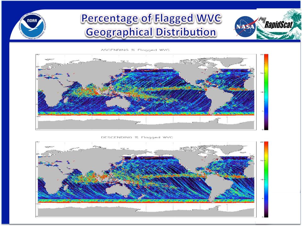
7 ² GOOD passes are when the radar is on and the space staron aftude is stable ² MARGINAL passes are when the aftude is so- so. Ø Marginal passes are when the aftude is so- so. Back scater measurement error varies in this situaron. Some measurements are good. Others are not. Marginal wind fields have accurate winds but also have lots of gaps where winds were not retrieved ² BAD passes are the ones when the radar was turned off or the space staron was flopping around. Ø These things happen for various reasons. For example radar have to be turned off to avoid irradiarng astronauts on a spacewalk for or when the space staron may spin about to allow a cargo vessel to dock in the preferred manner. ² Only GOOD and MARGINAL data are available in NRT

8

9

10 Start End Descrip=on Jan??, 2015 (mid Jan)??? RS may be off during an EVA for IDA prep Wed Jan 14, 2015 UTC??????? RS will be off during the departure of Dragon SpX- 5 Thu Dec 18, 2014 UTC???? Thu Dec 18 UTC???? RS will be off during the arrival of Dragon SpX- 5, (launch Dec 16, Tues, 19:31 UTC) Past Events: Thu Nov 27, 2014 UTC 0030 Thu Nov 27 UTC 1837 RS was off during a reconfigura=on of the Columbus Module. No data for RS Revs Sun Nov 23, 2014 UTC 1235 Mon Nov 24 UTC 2235 Arrival/docking of Soyuz 41S. ISS a_tude changed 20 degrees. No data for RS revs Wed Nov 12, 2014 UTC 1211 Wed Nov 12 UTC 1517 RS Rev 777 no data and 778 marginal. ISS maneuvered to avoid debris UTC1235 Sun Nov 09, 2014 UTC 2000 Mon Nov 10 UTC 1630 RS was off during the arrival of a visi=ng vehicle - no data for revs

11 ² 12.5km products Ø Uncorrected and corrected wind product ² RapidScat Version3 Cal/Val data package Ø Revs Ø Exclude MARGINAL and BAD revs ² Matchup with NCEP s GDAS Winds Ø Flagged retrieved WVC about 3-7%

12
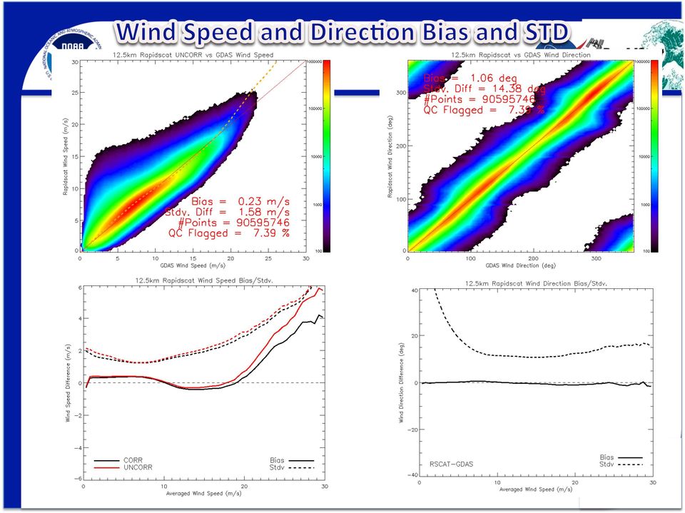
13 DESCENDING ASCENDING Wind Speed Bias and Stdv.

14
15 Courtesy of Lucrezia Ricciardulli RSS

16

17 ² RapidScat reveals HF winds at the northern part from storm center low on November 28 th,2014 at its 10:39Z pass. OPC upgraded its 12Z warning to hurricane force

18 12/21/2014 MTSAT- 2 IR image, RSCAT wind retrievals, & 06Z OPC surface analysis show 961mb in West Pacific hurricane force low

19 12/10/2014 RapidScat confirms hurricane force winds (brightest reds) in W/SW quadrants of Pacific low pressure

20 01/03/ Z RSCAT and 15Z ASCAT winds, Geocolor sat. image and 12Z OPC analysis within

21
22 Image courtesy of Tim Garner, NWS/Johnson Space Center ² RapidScat winds were requested to support first test flight of NASA s Orion spacecral. Orion is suppose to be launched Dec 4th, 2014 for 4 1/2h test mission. ² RapidScat wind data was made available in AWIPS2 readable form for this support
23 12/07/ Z OPC AtlanRc wind/wave analysis chart with corresponding RapidScat wind data
24 RapidScat is providing near real- Rme ocean surface vector wind data Quality comparable to that of QuikSCAT but there are srll areas for improvement 25km and 12.5km products are available in the NWS NAWIPS/NMAP environment and are being used to support the forecasrng and warning process The ISS orbit provides an opportunity to cross- calibrate satellite scaterometers and characterize the diurnal variability of OSVW.
Description of Scatterometer Data Products
 Scatterometer Data:// Description of Scatterometer Data Products QuikScat is no longer operational - last data recorded: 2009-Nov-23 REMSS QuikScat data set currently ends on 2009-11-19; data after that
The Future of Marine Weather Forecasting
 The Future of Marine Weather Forecasting Joe Sienkiewicz Chief, Ocean Applications Branch www.opc.ncep.noaa.gov 1 11/16/2010 ASTA 2010, Long Beach, CA Outline Ocean Prediction Center Graphical Product
TOPO Trajectory Operations Officer
 ISS Live! was developed at NASA s Johnson Space Center (JSC) under NASA Contracts NNJ14RA02C and NNJ11HA14C wherein the U.S. Government retains certain rights. Console Handbook TOPO Trajectory Operations
COASTAL WIND ANALYSIS BASED ON ACTIVE RADAR IN QINGDAO FOR OLYMPIC SAILING EVENT
 COASTAL WIND ANALYSIS BASED ON ACTIVE RADAR IN QINGDAO FOR OLYMPIC SAILING EVENT XIAOMING LI a, b, * a Remote Sensing Technology Institute, German Aerospace Center (DLR), Oberpfaffenhofen, 82234, Germany
Ensuring the Preparedness of Users: NOAA Satellites GOES R, JPSS Laura K. Furgione
 Ensuring the Preparedness of Users: NOAA Satellites GOES R, JPSS Laura K. Furgione U.S. Permanent Representative with the WMO Deputy Director, NOAA s s National Weather Service WMO Executive Council 65
Satellite SST Product Development Proposal
 Call for Proposals under the IMOS (EIF) Five Year Strategy: Enhancement or extension of IMOS July 2009 to June 2013 Satellite SST Products Sub-Facility Plan Overview: Proposed Infrastructure Investment:
ASCAT tandem coverage
 Ocean and Sea Ice SAF ASCAT tandem coverage Jeroen Verspeek Ad Stoffelen Version 0.8 2009-04-22 1 Introduction In order to examine the coverage of a system of two identical satellite scatterometers, a
Technical Attachment. The National Weather Service Estimated Actual Velocity Radar Tool. Ken Falk WFO Shreveport, Louisiana
 SRH STSD 2007-03 October 2007 Technical Attachment The National Weather Service Estimated Actual Velocity Radar Tool 1. Introduction Ken Falk WFO Shreveport, Louisiana A radar analysis tool has been introduced
Follow That Hurricane!
 Discover Your World With NOAA Follow That Hurricane! What You Will Do Devastating damage expected A most Track a hurricane on the same powerful hurricane with unprecedented type of chart used at the strength
Tropical Cyclone Report Hurricane Fausto (EP072008) 16-22 July 2008. John L. Beven II National Hurricane Center 19 November 2008
 16-22 July 2008. John L. Beven II National Hurricane Center 19 November 2008") Tropical Cyclone Report Hurricane Fausto (EP072008) 16-22 July 2008 John L. Beven II National Hurricane Center 19 November 2008 Fausto was a category 1 hurricane on the Saffir-Simpson Hurricane Scale that
Tropical Cyclone Report Hurricane Fausto (EP072008) 16-22 July 2008 John L. Beven II National Hurricane Center 19 November 2008 Fausto was a category 1 hurricane on the Saffir-Simpson Hurricane Scale that
Evaluation of sea surface salinity observed by Aquarius and SMOS
 SMOS & Aquarius science workshop (April 17, 2013) Evaluation of sea surface salinity observed by Aquarius and SMOS Hiroto Abe, Naoto Ebuchi (Hokkaido University, Japan) 1 Introduction (1/1) Aquarius V2.0
USING THE GOES 3.9 µm SHORTWAVE INFRARED CHANNEL TO TRACK LOW-LEVEL CLOUD-DRIFT WINDS ABSTRACT
 USING THE GOES 3.9 µm SHORTWAVE INFRARED CHANNEL TO TRACK LOW-LEVEL CLOUD-DRIFT WINDS Jason P. Dunion 1 and Christopher S. Velden 2 1 NOAA/AOML/Hurricane Research Division, 2 UW/CIMSS ABSTRACT Low-level
Huai-Min Zhang & NOAAGlobalTemp Team
 Improving Global Observations for Climate Change Monitoring using Global Surface Temperature (& beyond) Huai-Min Zhang & NOAAGlobalTemp Team NOAA National Centers for Environmental Information (NCEI) [formerly:
SDHNS 3 Hour English Food Handlers Class
 Mon Oct 3, 2011 English Class - San Diego (Downtown) Where: Nicky Rottens Bar and Burger Joint, 560 Fifth Ave., San Diego, CA 92101 Wed Oct 5, 2011 Fri Oct 7, 2011 12pm - 3pm Sat Oct 8, 2011 (No title)
Monitoring of Arctic Conditions from a Virtual Constellation of Synthetic Aperture Radar Satellites
 DISTRIBUTION STATEMENT A. Approved for public release; distribution is unlimited. Monitoring of Arctic Conditions from a Virtual Constellation of Synthetic Aperture Radar Satellites Hans C. Graber RSMAS
ASCAT services status Global and regional services
 ASCAT services status Global and regional services Craig Anderson, Hans Bonekamp, Leonid Butenko, Colin Duff, Julia Figa-Saldaña, Christelle Ponsard, Arthur de Smet and Julian Wilson (EUMETSAT) A.Stoffelen,
Monitoring of Arctic Conditions from a Virtual Constellation of Synthetic Aperture Radar Satellites
 DISTRIBUTION STATEMENT A. Approved for public release; distribution is unlimited. Monitoring of Arctic Conditions from a Virtual Constellation of Synthetic Aperture Radar Satellites Hans C. Graber RSMAS
The Threat of Orbital Debris and Protecting NASA Space Assets from Satellite Collisions 28 April 2009
 The Threat of Orbital Debris and Protecting NASA Space Assets from Satellite Collisions 28 April 2009 Executive Summary Collision avoidance processes are in place for all NASA human space flight missions
Enabling RTK-like positioning offshore using the global VERIPOS GNSS network. Pieter Toor GNSS Technology Manager
 Enabling RTK-like positioning offshore using the global VERIPOS GNSS network Pieter Toor GNSS Technology Manager Introduction PPP/RTK Positioning Techniques PPP-AR Technology Presentation Overview PPP-AR
Look at Our Galaxy. by Eve Beck. Space and Technology. Scott Foresman Reading Street 2.1.2
 Suggested levels for Guided Reading, DRA, Lexile, and Reading Recovery are provided in the Pearson Scott Foresman Leveling Guide. Space and Technology Look at Our Galaxy Genre Expository nonfiction Comprehension
1 In this report, "tropical cyclone (TC)" is used as a generic term that includes "low pressure area (LPA)", "tropical depression
 is used as a generic term that includes low pressure area (LPA), tropical depression") Comparative Study on Organized Convective Cloud Systems detected through Early Stage Dvorak Analysis and Tropical Cyclones in Early Developing Stage in the Western North Pacific and the South China Sea
Comparative Study on Organized Convective Cloud Systems detected through Early Stage Dvorak Analysis and Tropical Cyclones in Early Developing Stage in the Western North Pacific and the South China Sea
1. Introduction. FER-Zagreb, Satellite communication systems 2011/12
 1. Introduction Topics History Characteristics of satellite communications Frequencies Application 1 History Arthur C. Clark suggested in 1945. Earth coverage with 3 geostationary satellites. On 4th of
An A-Train Water Vapor Thematic Climate Data Record Using Cloud Classification
 An A-Train Water Vapor Thematic Climate Data Record Using Cloud Classification Eric J. Fetzer, Qing Yue, Alexandre Guillaume, Van T. Dang, Calvin Liang, Brian H. Kahn, Brian D. Wilson, Bjorn H. Lambrigtsen
Space Exploration Classroom Activity
 Space Exploration Classroom Activity The Classroom Activity introduces students to the context of a performance task, so they are not disadvantaged in demonstrating the skills the task intends to assess.
The USGS Landsat Big Data Challenge
 The USGS Landsat Big Data Challenge Brian Sauer Engineering and Development USGS EROS bsauer@usgs.gov U.S. Department of the Interior U.S. Geological Survey USGS EROS and Landsat 2 Data Utility and Exploitation
Kathryn A. Shontz STAR-NDE Liaison IMSG at NOAA/NESDIS/STAR Camp Springs, MD 20746. Ingrid Guch, Aleksandar Jelenak and Kent Hughes NOAA/NESDIS/STAR
 A Review of Improvements and Outstanding Challenges in Data Management and Stewardship by the Center for Satellite Applications and Research (STAR) in support of the NPOESS Preparatory Program (NPP) Satellite
The National Strategy, Current Activities for Space Technology Development and Application
 14-18 November 2011, Putrajaya, Malaysia The National Strategy, Current Activities for Space Technology Development and Application Lai Anh Khoi Space Technology Institute, VAST, Vietnam Bief History Space
Development of an Integrated Data Product for Hawaii Climate
 Development of an Integrated Data Product for Hawaii Climate Jan Hafner, Shang-Ping Xie (PI)(IPRC/SOEST U. of Hawaii) Yi-Leng Chen (Co-I) (Meteorology Dept. Univ. of Hawaii) contribution Georgette Holmes
There e really is No Place Like Rome to experience great Opera! Tel: 01213 573 866 to discuss your break to the Eternal City!
 There e really is No Place Like Rome to experience great Opera! Tel: 01213 573 866 to discuss your break to the Eternal City! Date Fri Location 11 Sep 2015 Teatro dell'opera di Roma Opera Sat 12 Sep 2015
How to analyze synoptic-scale weather patterns Table of Contents
 How to analyze synoptic-scale weather patterns Table of Contents Before You Begin... 2 1. Identify H and L pressure systems... 3 2. Locate fronts and determine frontal activity... 5 3. Determine surface
6.9 A NEW APPROACH TO FIRE WEATHER FORECASTING AT THE TULSA WFO. Sarah J. Taylor* and Eric D. Howieson NOAA/National Weather Service Tulsa, Oklahoma
 6.9 A NEW APPROACH TO FIRE WEATHER FORECASTING AT THE TULSA WFO Sarah J. Taylor* and Eric D. Howieson NOAA/National Weather Service Tulsa, Oklahoma 1. INTRODUCTION The modernization of the National Weather
Building a Weather- Ready Nation. NWS Office of Dissemination Partners Meeting January 14, 2016 New Orleans, LA
 Building a Weather- Ready Nation NWS Office of Dissemination Partners Meeting January 14, 2016 New Orleans, LA Topics Chronology One-NWS Network Dissemination outages during severe weather events Responses
Hyperspectral Satellite Imaging Planning a Mission
 Hyperspectral Satellite Imaging Planning a Mission Victor Gardner University of Maryland 2007 AIAA Region 1 Mid-Atlantic Student Conference National Institute of Aerospace, Langley, VA Outline Objective
LAUREA MAGISTRALE - CURRICULUM IN INTERNATIONAL MANAGEMENT, LEGISLATION AND SOCIETY. 1st TERM (14 SEPT - 27 NOV)
") LAUREA MAGISTRALE - CURRICULUM IN INTERNATIONAL MANAGEMENT, LEGISLATION AND SOCIETY 1st TERM (14 SEPT - 27 NOV) Week 1 9.30-10.30 10.30-11.30 11.30-12.30 12.30-13.30 13.30-14.30 14.30-15.30 15.30-16.30
LAUREA MAGISTRALE - CURRICULUM IN INTERNATIONAL MANAGEMENT, LEGISLATION AND SOCIETY 1st TERM (14 SEPT - 27 NOV) Week 1 9.30-10.30 10.30-11.30 11.30-12.30 12.30-13.30 13.30-14.30 14.30-15.30 15.30-16.30
Questions From / Answers To Potential Proposing Community. Most Current Update: Thursday, July 1, 2010. Question Number. Date Received.
 National Institutes of Health (NIH), DHHS - Funding Opportunity Announcement: Biomedical Research on the International Space Station (BioMed-ISS) (UH2/UH3) s From / s To Potential Proposing Community Most
TECHNICAL REPORTS. Authors: Tatsuhiro Noguchi* and Takaaki Ishikawa*
 Application and Evaluation of Observation Data by Advanced Microwave Scanning Radiometer 2 Achievement of World s Top-Class Microwave Radiometer AMSR Series Authors: Tatsuhiro Noguchi* and Takaaki Ishikawa*
Prediction of Storm Surge using Space Data. Susanne Lehner German Aerospace Center
 Prediction of Storm Surge using Space Data Susanne Lehner German Aerospace Center Existing Crisis Information State of the Art of Satellite Crisis Information (ZKI) Mapping after the storm www.zki.de
Presented by Gary Davis, Director, Office of Systems Development NOAA/NESDIS/OSD. Fifty Years of Achievement
 NOAA s Environmental Satellite Program: Past, Present, and Future Presented by Gary Davis, Director, Office of Systems Development NOAA/NESDIS/OSD 1 Space-Based Remote Sensors Changed Way We See Our World
Space Exploration. A Visual History. Philip Stooke
 Space Exploration A Visual History Philip Stooke It all began with Sputnik 4 th October 1957 It all began with Sputnik 4 th October 1957 It all began with Sputnik 4 th October 1957 and Laika Laika on the
Present Status of Coastal Environmental Monitoring in Korean Waters. Using Remote Sensing Data
 Present Status of Coastal Environmental Monitoring in Korean Waters Using Remote Sensing Data Sang-Woo Kim, Young-Sang Suh National Fisheries Research & Development Institute #408-1, Shirang-ri, Gijang-up,
SARAL ACCESS TO OFF-LINE DATA
 SARAL AltiKa introduction Plot of the SARAL/AltiKa ground track over Africa (Credits: Google). S ARAL/AltiKa is a new mission in cooperation between CNES and ISRO (Indian Space Research Organization),
Space Weather: Forecasting & Impacts on Critical Infrastructure
 Space Weather: Forecasting & Impacts on Critical Infrastructure Dr. Genene Fisher Senior Advisor for Space Weather National Weather Service AMS Washington Forum 12 April 2012 Outline Solar Activity Update
NASA ISS Research Academy and Pre-Application Meeting. Erin Beck Mission Integrator erin.beck@spacex.com August 4, 2010
 NASA ISS Research Academy and Pre-Application Meeting Erin Beck Mission Integrator erin.beck@spacex.com SpaceX Overview Founded in mid-2002 with the singular goal of providing highly reliable, low cost
A Microwave Retrieval Algorithm of Above-Cloud Electric Fields
 A Microwave Retrieval Algorithm of Above-Cloud Electric Fields Michael J. Peterson The University of Utah Chuntao Liu Texas A & M University Corpus Christi Douglas Mach Global Hydrology and Climate Center
SATELLITE OCEANOGRAPHY IN THE AZORES: PAST, PRESENT AND FUTURE
 SATELLITE OCEANOGRAPHY IN THE AZORES: PAST, PRESENT AND FUTURE Oceanography Section / DOP University of the Azores Ana Martins Email: anamartins@uac.pt Azores (NE Atlantic) - very exposed to harsh environments
NOAA Big Data Project. David Michaud Acting Director, Office of Central Processing Office Monday, August 3, 2015
 NOAA Big Data Project David Michaud Acting Director, Office of Central Processing Office Monday, August 3, 2015 Central Processing Portfolio Benefits and Scope Central Processing Portfolio Benefits Ensures
How Raising TRMM s Altitude to 400km Impacts PR Operation. June 1, 2001 NASDA EORC with support of PR team
 How Raising TRMM s Altitude to 400km Impacts PR Operation June 1, 2001 NASDA EORC with support of PR team 1. Background and Introduction TRMM is planned to make a controlled reentry at the end of its life
Sentinel-3 Marine Test Data Set processed at EUMETSAT
 Sentinel-3 Marine Test Data Set processed at EUMETSAT Doc.No. : EUM/TSS/TEN/15/822144 Issue : v2 e-signed Date : 15 December 2015 WBS/DBS : EUMETSAT Eumetsat-Allee 1, D-64295 Darmstadt, Germany Tel: +49
STATUS AND RESULTS OF OSEs. (Submitted by Dr Horst Böttger, ECMWF) Summary and Purpose of Document
 Summary and Purpose of Document") WORLD METEOROLOGICAL ORGANIZATION COMMISSION FOR BASIC SYSTEMS OPEN PROGRAMMME AREA GROUP ON INTEGRATED OBSERVING SYSTEMS EXPERT TEAM ON OBSERVATIONAL DATA REQUIREMENTS AND REDESIGN OF THE GLOBAL OBSERVING
WORLD METEOROLOGICAL ORGANIZATION COMMISSION FOR BASIC SYSTEMS OPEN PROGRAMMME AREA GROUP ON INTEGRATED OBSERVING SYSTEMS EXPERT TEAM ON OBSERVATIONAL DATA REQUIREMENTS AND REDESIGN OF THE GLOBAL OBSERVING
Development of a Sun Synchronous. Conjunctions
 Development of a Sun Synchronous Zoning Architecture to Minimize Conjunctions Kevin Shortt Brian Weeden Secure World Foundation www.secureworldfoundation.org Overview Current Situation in Sun synchronous
Update on EUMETSAT ocean colour services. Ewa J. Kwiatkowska
 Update on EUMETSAT ocean colour services Ewa J. Kwiatkowska 1 st International Ocean Colour Science meeting, 6 8 May, 2013 EUMETSAT space data provider for operational oceanography Operational data provider
NOAA and Its Role in Managing Satellite Data
 NOAA is dedicated to serving society by providing timely access to global environmental data from satellites and other sources to promote, protect, and enhance the Nation s economy, security, environment,
Satellite Remote Sensing of Volcanic Ash
 Marco Fulle www.stromboli.net Satellite Remote Sensing of Volcanic Ash Michael Pavolonis NOAA/NESDIS/STAR SCOPE Nowcasting 1 Meeting November 19 22, 2013 1 Outline Getty Images Volcanic ash satellite remote
Space Weather Prediction Research and Services for China Manned Space Mission
 Space Weather Prediction Research and Services for China Manned Space Mission Siqing Liu National Space Science Center, CAS Center for Space Science and Applied Research, CAS Outline I. General information
Hurricanes. Characteristics of a Hurricane
 Hurricanes Readings: A&B Ch. 12 Topics 1. Characteristics 2. Location 3. Structure 4. Development a. Tropical Disturbance b. Tropical Depression c. Tropical Storm d. Hurricane e. Influences f. Path g.
National Data Buoy Center Command Briefing For
 National Data Buoy Center Command Briefing For Marine Technology Society Oceans in Action August 21, 2014 Helmut H. Portmann, Director National Data Buoy Center To provide a real-time, end-to-end capability
Astronomical applications of the over-the-horizon radar NOSTRADAMUS
 Astronomical applications of the over-the-horizon radar NOSTRADAMUS J-F. Degurse 1,2, J-Ph. Molinié 1, V. Rannou 1,S. Marcos 2 1 ONERA, Département Electromagnétisme et Radar 2 L2S Supéléc, CNRS UMR 8506,
THE STRATEGIC PLAN OF THE HYDROMETEOROLOGICAL PREDICTION CENTER
 THE STRATEGIC PLAN OF THE HYDROMETEOROLOGICAL PREDICTION CENTER FISCAL YEARS 2012 2016 INTRODUCTION Over the next ten years, the National Weather Service (NWS) of the National Oceanic and Atmospheric Administration
How To Write A Call To Action For Terrasar-X
 Doc.: TX-PGS-PL-4127 TerraSAR-X Announcement of Opportunity: Utilization of the TerraSAR-X Archive 1 Page: 2 of 11 TABLE OF CONTENTS TERRASAR-X... 1 ANNOUNCEMENT OF OPPORTUNITY: UTILIZATION OF THE TERRASAR-X
Multiangle cloud remote sensing from
 Multiangle cloud remote sensing from POLDER3/PARASOL Cloud phase, optical thickness and albedo F. Parol, J. Riedi, S. Zeng, C. Vanbauce, N. Ferlay, F. Thieuleux, L.C. Labonnote and C. Cornet Laboratoire
How To Train To Be A Volunteer At A Church
 2014 Tax Season Training Schedule TABLE OF CONTENTS Registering for Training 2 Training Updates 2 3 Summary of Training Requirements 3 Volunteer Orientation 4 Front Desk Manager Training 5 C.A.S.H. Advisor
Tropical Cyclogenesis Monitoring at RSMC Tokyo Mikio, Ueno Forecaster, Tokyo Typhoon Center Japan Meteorological Agency (JMA)
") JMA/WMO Workshop on Effective Tropical Cyclone Warning in Southeast Asia 11 14 March, 2014 Tropical Cyclogenesis Monitoring at RSMC Tokyo Mikio, Ueno Forecaster, Tokyo Typhoon Center Japan Meteorological
JMA/WMO Workshop on Effective Tropical Cyclone Warning in Southeast Asia 11 14 March, 2014 Tropical Cyclogenesis Monitoring at RSMC Tokyo Mikio, Ueno Forecaster, Tokyo Typhoon Center Japan Meteorological
SPATIAL DISTRIBUTION OF NORTHERN HEMISPHERE WINTER TEMPERATURES OVER THE SOLAR CYCLE DURING THE LAST 130 YEARS
 SPATIAL DISTRIBUTION OF NORTHERN HEMISPHERE WINTER TEMPERATURES OVER THE SOLAR CYCLE DURING THE LAST 130 YEARS Kalevi Mursula, Ville Maliniemi, Timo Asikainen ReSoLVE Centre of Excellence Department of
The Apollo Program. PTYS 395 October 9, 2008 Sarah Mattson
 The Apollo Program PTYS 395 October 9, 2008 Sarah Mattson May 25, 1961 President Kennedy announces the Apollo Program. The goal was to put a man on the Moon, and return him safely to Earth, by the end
How Long Do You Need To Achieve Your Scientific Objectives?
 How Long Do You Need To Achieve Your Scientific Objectives? Time seconds minutes days/weeks months Drop Towers/Drop Tubes KC-135 Parabolic Flights Balloons* Sounding Rockets Alternate Carriers* Shuttle
Clear Sky Radiance (CSR) Product from MTSAT-1R. UESAWA Daisaku* Abstract
 Product from MTSAT-1R. UESAWA Daisaku* Abstract") Clear Sky Radiance (CSR) Product from MTSAT-1R UESAWA Daisaku* Abstract The Meteorological Satellite Center (MSC) has developed a Clear Sky Radiance (CSR) product from MTSAT-1R and has been disseminating
Clear Sky Radiance (CSR) Product from MTSAT-1R UESAWA Daisaku* Abstract The Meteorological Satellite Center (MSC) has developed a Clear Sky Radiance (CSR) product from MTSAT-1R and has been disseminating
Remote Sensing Satellite Information Sheets Geophysical Institute University of Alaska Fairbanks
 Remote Sensing Satellite Information Sheets Geophysical Institute University of Alaska Fairbanks ASTER Advanced Spaceborne Thermal Emission and Reflection Radiometer AVHRR Advanced Very High Resolution
Near Real Time Blended Surface Winds
 Near Real Time Blended Surface Winds I. Summary To enhance the spatial and temporal resolutions of surface wind, the remotely sensed retrievals are blended to the operational ECMWF wind analyses over the
NWP SAF. SDP User Manual and Reference Guide. Satellite Application Facility for Numerical Weather Prediction. KNMI Scatterometer Team
 Satellite Application Facility for Numerical Weather Prediction Document NWPSAF-KN-UD-002 Version 2.2 11-09-2014 Reference Guide KNMI Scatterometer Team Jur Vogelzang, Anton Verhoef, Jeroen Verspeek, Jos
DISCOVER AQ OUTLOOK Thursday January 31, 2013
 DISCOVER AQ OUTLOOK Thursday January 31, 2013 PODEX coastal leg (LA) Oxnard NWS forecasted narrow patch of stratus within 50 miles of the coast, but the main lower level cloud deck would be out past 125+
8. Communications Subsystem
 PM-1.1-03 Rev C 8. Communications Subsystem The GOES-NOP spacecraft communications subsystem provides requisite conditioning, transmission, reception, and routing of mission data signals and telemetry
Developing Metrics in Systems Integration (ISS Program COTS Integration Model)
") Developing Metrics in Systems Integration (ISS Program COTS Integration Model) Kathryn Lueders COTS Integration Manager International Space Station Program August 22, 2007 System Integration Challenges
Developing Metrics in Systems Integration (ISS Program COTS Integration Model) Kathryn Lueders COTS Integration Manager International Space Station Program August 22, 2007 System Integration Challenges
Global Earth Observation Integrated Data Environment (GEO-IDE) Presentation to the Data Archiving and Access Requirements Working Group (DAARWG)
 Presentation to the Data Archiving and Access Requirements Working Group (DAARWG)") Global Earth Observation Integrated Data Environment (GEO-IDE) Presentation to the Data Archiving and Access Requirements Working Group (DAARWG) Ken McDonald Data Management Integration Architect National
Global Earth Observation Integrated Data Environment (GEO-IDE) Presentation to the Data Archiving and Access Requirements Working Group (DAARWG) Ken McDonald Data Management Integration Architect National
UNCLASSIFIED FY 2015. Quantity of RDT&E Articles 0.000 - - - - - - - - - MDAP/MAIS Code: 488
 Exhibit R-2, RDT&E Budget Item Justification: PB 2015 Air Force : March 2014 3600: Research, Development, Test & Evaluation, Air Force / BA 4: Advanced Component Development & Prototypes (ACD&P) COST ($
Daily High-resolution Blended Analyses for Sea Surface Temperature
 Daily High-resolution Blended Analyses for Sea Surface Temperature by Richard W. Reynolds 1, Thomas M. Smith 2, Chunying Liu 1, Dudley B. Chelton 3, Kenneth S. Casey 4, and Michael G. Schlax 3 1 NOAA National
Commercial Crew Program Status
 National Aeronautics and Space Administration Commercial Crew Program Status for the NAC Presenter Title Date Philip McAlister of Presentation Acting Director, Commercial Spaceflight Development NASA HQ
RS platforms. Fabio Dell Acqua - Gruppo di Telerilevamento
 RS platforms Platform vs. instrument Sensor Platform Instrument The remote sensor can be ideally represented as an instrument carried by a platform Platforms Remote Sensing: Ground-based air-borne space-borne
What s better than a milliondollar
 F o r k i d s o f a l l a g e s BY MEMORIE YASUDA What s better than a milliondollar view from the top of a skyscraper? Try a multimillion-dollar view from a satellite flying around Earth. A satellite
CBERS Program Update Jacie 2011. Frederico dos Santos Liporace AMS Kepler liporace@amskepler.com
 CBERS Program Update Jacie 2011 Frederico dos Santos Liporace AMS Kepler liporace@amskepler.com Overview CBERS 3 and 4 characteristics Differences from previous CBERS satellites (CBERS 1/2/2B) Geometric
V6 AIRS Spectral Calibra2on
 V6 AIRS Spectral Calibra2on Evan Manning Bob Deen Yibo Jiang George Aumann Denis EllioA Jet Propulsion Laboratory California Ins2tute of Technology 5/4/09 1 Spectral Calibra2on Primer AIRS measures radiance
orion Final assembly of EFT-1 spacecraft begins with KSC arrival June 2012 MONTHLY ACCOMPLISHMENTS
 MONTHLY ACCOMPLISHMENTS June 2012 orion Final assembly of EFT-1 spacecraft begins with KSC arrival With more than 450 people in attendance, the Orion Exploration Flight Test (EFT-1) flight vehicle was
Service Assessment Pacific Northwest Storms of December 1-3, 2007
 Service Assessment Pacific Northwest Storms of December 1-3, 2007 U.S. DEPARTMENT OF COMMERCE National Oceanic and Atmospheric Administration National Weather Service Silver Spring, Maryland Cover Photograph:
2016 Tax Season Training Schedule
 2016 Tax Season Training Schedule TABLE OF CONTENTS Registering for Training 2 Training Materials 2 Front Desk Manager Training 2 C.A.S.H. Advisor Training 3 Tax Preparer Training 4 Basic Tax Training
The NASA Global Differential GPS System (GDGPS) and The TDRSS Augmentation Service for Satellites (TASS)
 and The TDRSS Augmentation Service for Satellites (TASS)") The Global Differential GPS System (GDGPS) and The TDRSS Augmentation Service for Satellites (TASS) Yoaz Bar-Sever, Larry Young, Frank Stocklin, Paul Heffernan and John Rush s Global Differential GPS System
The Global Differential GPS System (GDGPS) and The TDRSS Augmentation Service for Satellites (TASS) Yoaz Bar-Sever, Larry Young, Frank Stocklin, Paul Heffernan and John Rush s Global Differential GPS System
CCAR Near Real Time and Historical Altimeter Data Server
 CCAR Near Real Time and Historical Altimeter Data Server http://eddy.colorado.edu/ccar/data_viewer/index Bob Leben March 2015 GCOOS BOD Meeting CCAR Near Real Time Altimeter Data System! In late 1995,
Understanding the altimeter
 Understanding the altimeter What you see isn't always what you have by Jack Willams Flying is an adventure for most pilots--sometimes more adventure than they really want. A pilot's report to Canada's
IAC-08-B3.3.04 PROPOSAL FOR MODIFICATION OF ISS. Japan,Tokyo http://www.soranokai.jp/
 IAC-08-B3.3.04 PROPOSAL FOR MODIFICATION OF ISS Fujio.NAKANO 1, Tomifumi.GODAI 2 1 Space Policy Think-tank [SORANOKAI] 2 Space Policy Think-tank[SORANOKAI] Japan,Tokyo http://www.soranokai.jp/ E-mail 1
NOAA s National Weather Service Milwaukee/Sullivan
 NOAA s National Weather Service Milwaukee/Sullivan Marcia Cronce Meteorologist, Aviation Focal Point August 2014 weather.gov/milwaukee NWS Part of the Federal Government DOC - Department of Commerce NOAA
Real-time Ocean Forecasting Needs at NCEP National Weather Service
 Real-time Ocean Forecasting Needs at NCEP National Weather Service D.B. Rao NCEP Environmental Modeling Center December, 2005 HYCOM Annual Meeting, Miami, FL COMMERCE ENVIRONMENT STATE/LOCAL PLANNING HEALTH
Yield Management in the Railroad Industry Supporting Supply Chain Partnerships
 Yield Management in the Railroad Industry Supporting Supply Chain Partnerships November 14, 2011 Jason Kuehn Associate Partner INFORMS Conference, Charlotte, NC Surface Transportation Section 1 CAPITAL
A SEVERE WEATHER CLIMATOLOGY FOR THE WILMINGTON, NC WFO COUNTY WARNING AREA
 A SEVERE WEATHER CLIMATOLOGY FOR THE WILMINGTON, NC WFO COUNTY WARNING AREA Carl R. Morgan National Weather Service Wilmington, NC 1. INTRODUCTION The National Weather Service (NWS) Warning Forecast Office
Emergency Managers Weather Information Network (EMWIN) Service Transition 2016/2017
 Service Transition 2016/2017") EMWIN Stakeholder Meeting April 19, 2015 Emergency Managers Weather Information Network (EMWIN) Service Transition 2016/2017 Dissemination Systems Team, NWS Office of Dissemination Program Manager: Craig
EMWIN Stakeholder Meeting April 19, 2015 Emergency Managers Weather Information Network (EMWIN) Service Transition 2016/2017 Dissemination Systems Team, NWS Office of Dissemination Program Manager: Craig
S.No Scientific positions No Of Posts Pay Band Grade Pay 10 `. 15600-39100 ` 7600 04 `. 15600-39100 ` 7600 03 `. 15600-39100 ` 7600
 EARTH SYSTEM SCIENCE ORGANIZATION (ESSO) Ministry of Earth Sciences, Government of India INDIAN INSTITUTE OF TROPICAL METEOROLOGY, PUNE-411008 Advertisement No. PER/4/2014 The Indian Institute of Tropical
[ Climate Data Collection and Forecasting Element ] An Advanced Monitoring Network In Support of the FloodER Program
![[ Climate Data Collection and Forecasting Element ] An Advanced Monitoring Network In Support of the FloodER Program](/thumbs/33/16326315.jpg "[ Climate Data Collection and Forecasting Element ] An Advanced Monitoring Network In Support of the FloodER Program") [ Climate Data Collection and Forecasting Element ] An Advanced Monitoring Network In Support of the FloodER Program December 2010 1 Introduction Extreme precipitation and the resulting flooding events
[ Climate Data Collection and Forecasting Element ] An Advanced Monitoring Network In Support of the FloodER Program December 2010 1 Introduction Extreme precipitation and the resulting flooding events
Improved Warnings for Natural Hazards: A Prototype System for Southern California
 Improved Warnings for Natural Hazards: A Prototype System for Southern California Yehuda Bock Research Geodesist Scripps Institution of Oceanography University of California San Diego, La Jolla, Calif.
NOTICE: This publication is available at: http://www.nws.noaa.gov/directives/.
 Department of Commerce National Oceanic & Atmospheric Administration National Weather Service NATIONAL WEATHER SERVICE INSTRUCTION 10-1604 July 29, 2011 Operations and Services Performance, NWSPD 10-16
Review for Introduction to Remote Sensing: Science Concepts and Technology
 Review for Introduction to Remote Sensing: Science Concepts and Technology Ann Johnson Associate Director ann@baremt.com Funded by National Science Foundation Advanced Technological Education program [DUE
2016 Examina on dates
 Please note the following informa on: The following exams are available throughout the year: Please click on the exam for which you wish to see the dates. When you have finished, you can select to return
Forecast-Informed Reservoir Operations: A Concept Supporting Water Supply and Flood Control
 16 inches of rain in 1 day in Central California Forecast-Informed Reservoir Operations: A Concept Supporting Water Supply and Flood Control Developed by the Center for Western Weather and Water Extremes
Manage the RAID system from event log
 Manage the RAID system from event log Tim Chung Version 1.0 (JAN, 2010) - 1 - QSAN Technology, Inc. http://www.qsantechnology.com White Paper# QWP201001-ALL lntroduction Event log records the information