Fluvial Processes, Patterns and Landforms
|
|
|
- Cleopatra Norton
- 7 years ago
- Views:
Transcription
1 Fluvial Processes, Patterns and Landforms
2 Exam Questions Examine the diagrams A, B and C below Name each of the three river drainage patterns Explain the formation of any two Irish landforms caused by surface processes with the aid of diagrams
3 Keywords Introduction to Rivers Hydrological Cycle Basin Watershed Source Tributaries Confluence Mouth Discharge Long Profile Base Level
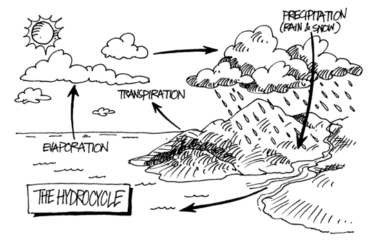
4 CONDENSATION

5
6 Drainage Patterns
7 DendriticDrainage One major river with several small tributaries; the network of streams resembles the branches of a tree converging upon the trunk. This pattern will occur on any rock type. Rivers Shannon and Boyne are examples of this pattern
8 Trellis Pattern Tributaries flow at right angles into a main river. This is because the surface consists of alternating hard and soft rock; the streams erode the softer rock but find it difficult to break through the hard rock E.g. the Blackwater River
9 Radial Pattern This pattern will develop in upland areas where several streams will flow outwards and downwards from a central point. The various streams will flow in different directions E.g. SlieveBeaghCo. Monahan
10 River Erosion Keywords Erosion Lateral Vertical Hydraulic Action Cavitation Abrasion Corrasion Solution Attrition

11 Erosion When the river channel is widened it is called lateral erosion Vertical Erosion is the deepening of the river bed
12 flash/erosion.swf

13
14 Upper Course Features Interlocking Spurs V Shaped Valleys Waterfalls
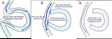
15
16 Mature Stage Flood Plain Meander Ox Bow Lake
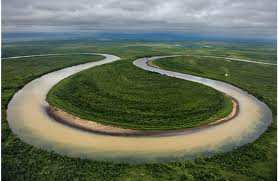
17 Example River Boyne in Co. Meath Name: Meander Description S shaped bends in a river Formation Main processes: Lateral erosion Hydraulic Action Abrasion Deposition
18 Meander A meander is a curve in the river. It happens when the river meets a bend. As the river flows around it erodes the outside of the bend as the strongest flow is here. This causes a river cliff Slacker or shallower water flows on the inside of the bend and have less power deposition happens. This area of deposition is called a point bar

19 Deposition Point Bar Erosion River Cliff
20
21 Name Ox Bow Lakes Example River Moy Co. Mayo Description Oxbow lakes are the remains of meanders that have been cut off from the rivers course. Formation Main Processes Erosion and Deposition
22 Ox Bow Lakes Ox bow lakes forms when a meander becomes very pronounced. A narrow neck develops and in times of flood the main flow cuts across the neck to flow straight. It cuts off the loop of the meander and becomes an ox bow lake.
23

24 Meander Scar/Mort Lake
25
26 Example River Suir Co. Waterford Name Flood Plain Description A flat area of land either side of a river Formation Main Processes Flooding Deposition
27 Flood Plain As a river meanders the land on either side is gradually worn back into bluffs of higher land. It is the flat land in the centre of a valley
28 Old Stage Levees Deltas
29 Deposition A river deposits material due to a reduction in energy. This generally occurs because of 1. Decreasing Velocity 2. Increase in Volume 3. Increase in the size of its load due to A fast flowing tributary adding extra material Heavy rainfall
30 Example River Moy Co. Mayo Name Levee Description A ridge of sediment deposited on river banks Formation Deposition
31
32 Name Delta Example Shannon Estuary Description Areas of land at the mouth of a river made form deposits of sand and gravel. Formation Deposition
33 A delta forms where a river reaches a sea or lake. It slows down, loses power and deposits the material it has been carrying. If the sea is sheltered and there is not much wave action this material will build up into a delta. As it is deposited it falls into different layers It blocks up the river channel forcing it to break up into smaller river channels called distributaries.

34 River Channel Deposition Distributaries
35 Types of Deltas
Earth Science. River Systems and Landforms GEOGRAPHY 1710. The Hydrologic Cycle. Introduction. Running Water. Chapter 14.
 Earth Science GEOGRAPHY 1710 River Systems and Landforms DAVID R. SALLEE Robert W. Christopherson Charlie Thomsen Chapter 14 Introduction Rivers and streams are dynamic systems that continually adjust
WEATHERING, EROSION, and DEPOSITION REVIEW
 WEATHERING, EROSION, and DEPOSITION REVIEW Weathering: The breaking up of rock from large particles to smaller particles. a) This Increases surface area of the rock which speeds the rate of chemical weathering.
WEATHERING, EROSION, AND DEPOSITION PRACTICE TEST. Which graph best shows the relative stream velocities across the stream from A to B?
 NAME DATE WEATHERING, EROSION, AND DEPOSITION PRACTICE TEST 1. The diagram below shows a meandering stream. Measurements of stream velocity were taken along straight line AB. Which graph best shows the
8/18/2014. Chapter 9: Erosion and Deposition. Section 1 (Changing Earth s Surface) 8 th Grade. Weathering
 8 th Grade. Weathering") Section 1 (Changing Earth s Surface) Weathering the chemical and physical processes that break down rock at Earth s surface Chapter 9: Erosion and Deposition 8 th Grade Mechanical weathering when rock
Section 1 (Changing Earth s Surface) Weathering the chemical and physical processes that break down rock at Earth s surface Chapter 9: Erosion and Deposition 8 th Grade Mechanical weathering when rock
Neversink River East Branch
 Neversink River East Branch Management Unit 10 Summary of Post-Flood Recommendations Intervention Level Full restoration of the stream reach including the eroding bank site between Station 38380 and Station
Flash Flood Science. Chapter 2. What Is in This Chapter? Flash Flood Processes
 Chapter 2 Flash Flood Science A flash flood is generally defined as a rapid onset flood of short duration with a relatively high peak discharge (World Meteorological Organization). The American Meteorological
GLOSSARY OF TERMS CHAPTER 11 WORD DEFINITION SOURCE. Leopold
 CHAPTER 11 GLOSSARY OF TERMS Active Channel The channel that contains the discharge Leopold where channel maintenance is most effective, sediment are actively transported and deposited, and that are capable
Deserts, Wind Erosion and Deposition
 Deserts, Wind Erosion and Deposition By definition, a desert has less than 10 in (25 cm) of precipitation per year. Deserts occur at 30 o and 60 o in regions of descending air. Deserts can be hot or cold.
GY301 Geomorphology Fluvial Erosion Landforms
 Introduction Running water is by far the most important erosional agent on Earth. Even in arid climates, it is the primary agent of erosion. This is evident from the abundance of stream beds found throughout
Climate, Vegetation, and Landforms
 Climate, Vegetation, and Landforms Definitions Climate is the average weather of a place over many years Geographers discuss five broad types of climates Moderate, dry, tropical, continental, polar Vegetation:
How To Check For Scour At A Bridge
 Case Studies Bridge Scour Inspection and Repair Edward P. Foltyn, P.E. Senior Hydraulic Engineer ODOT Bridge Unit 2013 PNW Bridge Inspectors Conference April 2013 REFERENCES Stream Stability at Highway
Stream Rehabilitation Concepts, Guidelines and Examples. Objectives. Pierre Y. Julien. Three Laws of Stream Restoration
 Stream Rehabilitation Concepts, Guidelines and Examples Pierre Y. Julien Wuhan 2005 Objectives Part I - Stream restoration and rehabilitation: 1. Present and discuss important concepts, laws, criteria
CITY UTILITIES DESIGN STANDARDS MANUAL
 CITY UTILITIES DESIGN STANDARDS MANUAL Book 2 (SW) SW9 June 2015 SW9.01 Purpose This Chapter provides information for the design of open channels for the conveyance of stormwater in the City of Fort Wayne.
7.0 Stream Restoration
 7.0 Stream Restoration 7.1 Issue Statements One of the primary concerns of residents in the Bassett Creek watershed is the maintenance of the natural beauty of the creek in residential and recreational
Catchment Scale Processes and River Restoration. Dr Jenny Mant Jenny@therrc.co.uk. The River Restoration Centre therrc.co.uk
 Catchment Scale Processes and River Restoration Dr Jenny Mant Jenny@therrc.co.uk The River Restoration Centre therrc.co.uk 3 Main Catchment Elements Hydrology Energy associated with the flow of water affects
Environmental Case Study Decatur, Georgia, DeKalb County A Suburban Creek Resists Channelization
 Introduction A visual examination of Doolittle Creek in a highly developed suburban county in Georgia yielded telltale signs of a creek whose original streambed had been altered. Examination of official
Basic Soil Erosion and Types
 Basic Soil Erosion and Types 2015 Wisconsin Lakes Convention Stacy Dehne DATCP Engineer Types of Soil Erosion Rain drop or splash erosion: Erosion preceded by the destruction of the crumb structure due
Geography. Geography B. Exemplar Candidate Work Rivers GCSE 2012. Version 1 November 2012
 Geography GCSE 2012 Geography B Exemplar Candidate Work Rivers Version 1 November 2012 www.ocr.org.uk/gcse2012 CONTENTS Question 3 Exemplar Candidate Work 4 Assessor Comments 21 GCSE Geography Bexemplar
5 th Grade Science Vocabulary Words
 5 th Grade Science Vocabulary Words abiotic factor A nonliving part of an ecosystem. acceleration Change in velocity with respect to time. action The force one object applies to a second, as in Newton
Advice For the multiple-choice questions, completely fill in the circle alongside the appropriate answer(s).
.") SPECIMEN ASSESSMENT MATERIAL GCSE GEOGRAPHY Paper 1 Living with the physical environment Specimen Materials For this paper you must have: a pencil a ruler. Time allowed: 1 hour 30 minutes Instructions
SPECIMEN ASSESSMENT MATERIAL GCSE GEOGRAPHY Paper 1 Living with the physical environment Specimen Materials For this paper you must have: a pencil a ruler. Time allowed: 1 hour 30 minutes Instructions
2 Wind Erosion and Deposition
 CHAPTER 3 2 Wind Erosion and Deposition SECTION Agents of Erosion and Deposition BEFORE YOU READ After you read this section, you should be able to answer these questions: How can wind erosion shape the
BRIDGE SCOUR INVESTIGATION: DEVELOPING A SCREENING AND HYDRAULIC VULNERABILITY RATING SYSTEM FOR BRIDGES B.HERON 1 & C.BOWE 2
 BRIDGE SCOUR INVESTIGATION: DEVELOPING A SCREENING AND HYDRAULIC VULNERABILITY RATING SYSTEM FOR BRIDGES B.HERON 1 & C.BOWE 2 1 O Connor Sutton Cronin Consulting Engineers, Dublin, Ireland 2 Iarnród Éireann,
General Permit for Activities Promoting Waterway - Floodplain Connectivity [working title]
![General Permit for Activities Promoting Waterway - Floodplain Connectivity [working title]](/thumbs/39/18645965.jpg "General Permit for Activities Promoting Waterway - Floodplain Connectivity [working title]") General Permit for Activities Promoting Waterway - Floodplain Connectivity [working title] Purpose These rules set forth the conditions under which a person may, without an individual removal-fill permit
General Permit for Activities Promoting Waterway - Floodplain Connectivity [working title] Purpose These rules set forth the conditions under which a person may, without an individual removal-fill permit
Small Dam Hazard Assessment Inventory
 Small Dam Hazard Assessment Inventory What would happen if your dam were to fail? This is a question that most dam owners hope they will never have to answer. However it is a question you, as a responsible
4.2 Buena Vista Creek Watershed
 Buena Vista Creek Watershed 4.2 Buena Vista Creek Watershed Watershed Overview The Buena Vista Creek Watershed is the fourth-largest system within the Carlsbad Hydrologic Unit. The watershed extends approximately
Accretion Sediments carried by a stream and deposited along banks or surrounding areas.
 GLOSSARY Accretion Sediments carried by a stream and deposited along banks or surrounding areas. Acre-foot A quantity or volume of water covering one acre to a depth of one foot (43,560 cubic feet). Active
Igneous rocks formed when hot molten material (magma) cools and hardens (crystallizes).
 cools and hardens (crystallizes).") Objectives You will learn about how the land of North Dakota was formed. Introduction North Dakota is a wonderful place to live. Have you ever though about how it was formed? To answer that question, you
Objectives You will learn about how the land of North Dakota was formed. Introduction North Dakota is a wonderful place to live. Have you ever though about how it was formed? To answer that question, you
Basic Hydrology. Time of Concentration Methodology
 Basic Hydrology Time of Concentration Methodology By: Paul Schiariti, P.E., CPESC Mercer County Soil Conservation District What is the Time of Concentration? The time it takes for runoff to travel from
Course Plan Day 1: Introduction and Overview Hydrology & Fluvial Geomorphology Day 2: Fieldwork on the Braid Burn Alan Jones
 Course Plan Day 1: Introduction and Overview Hydrology & Fluvial Geomorphology Alan Jones E:mail: Alan.Jones@ed.ac.uk Water cycle Globally & Locally River shapes and forms River behaviour Closer look at
Geomorphology is the Study of Landforms. Usually by Erosion, Transportation and Deposition
 Geomorphology is the Study of Landforms and the Processes that t Create Them, Usually by Erosion, Transportation and Deposition Fluvial = running water, rivers and floodplains Glacial = flowing ice in
Emergency Spillways (Sediment basins)
") Emergency Spillways (Sediment basins) DRAINAGE CONTROL TECHNIQUE Low Gradient Velocity Control Short-Term Steep Gradient Channel Lining Medium-Long Term Outlet Control Soil Treatment Permanent [1] [1]
Emergency Spillways (Sediment basins) DRAINAGE CONTROL TECHNIQUE Low Gradient Velocity Control Short-Term Steep Gradient Channel Lining Medium-Long Term Outlet Control Soil Treatment Permanent [1] [1]
EFFECTS OF ARUNDO DONAX ON RIVER HYDRAULICS, SEDIMENT TRANSPORT, AND GEOMORPHOLOGY, SANTA MARGARITA RIVER, CALIFORNIA
 EFFECTS OF ARUNDO DONAX ON RIVER HYDRAULICS, SEDIMENT TRANSPORT, AND GEOMORPHOLOGY, SANTA MARGARITA RIVER, CALIFORNIA René Leclerc Geomorphologist Robert C. MacArthur, Ph.D., P.E. Principal Headwaters
WONDERFUL, WATERFUL WETLANDS
 WONDERFUL, WATERFUL WETLANDS OBJECTIVES The student will do the following: 1. List characteristics of wetlands. SUBJECTS: Science, Language Arts TIME: 60 minutes 2. Describe the functions of a wetland.
The Hydrologic Engineering Center Training Course on
 The Hydrologic Engineering Center Training Course on SEDIMENT TRANSPORT ANALYSIS WITH HEC-RAS Davis, California Course Objectives This course is intended to prepare engineers to perform studies using various
Detention Ponds. Detention Ponds. Detention Ponds. Detention Ponds. Detention Ponds. Detention Ponds. CIVL 1112 Detention Ponds - Part 1 1/12
 CIVL 1112 - Part 1 1/12 The water cycle, also known as the hydrologic cycle, describes the continuous movement of water on, above and below the surface of the Earth. The water cycle, also known as the
BLACK/HARMONY/FAREWELL CREEK WATERSHED EXISTING CONDITIONS REPORT CHAPTER 12 - STORMWATER MANAGEMENT
 Harmony Creek subwatershed Harmony Creek subwatershed BLACK/HARMONY/FAREWELL CREEK WATERSHED EXISTING CONDITIONS REPORT CHAPTER 12 - STORMWATER MANAGEMENT April 2011 TABLE OF CONTENTS 1.0 INTRODUCTION...
The Hydrologic Cycle. precipitation evaporation condensation transpiration infiltration surface runoff transport groundwater water table.
 The Hydrologic Cycle Page 1 of 1 Name Directions: The hydrologic cycle consists of the processes that change and move water through the earth s system. Use the terms below to label the hydrologic cycle.
Floodplain Connectivity in Restoration Design
 Floodplain Connectivity in Restoration Design 2015 Symposium on Restoration in a Contaminated Environment: Lessons Learned and Challenges in Moving Forward Part II April 2015 Karin Boyd Applied Geomorphology,
5.0 OVERVIEW OF FLOOD DAMAGE REDUCTION MEASURES
 5.0 OVERVIEW OF FLOOD DAMAGE REDUCTION MEASURES Flood damage reduction consists of two basic techniques structural and non-structural. Structural methods modify the flood and take the flood away from people
Earth Science Landforms, Weathering, and Erosion Reading Comprehension. Landforms, Weathering, and Erosion
 Reading Comprehension Name 1 How many people have been to the Rocky Mountains or the Grand Canyon? When people go to visit these natural wonders, they may not realize that it took millions of years for
The rock cycle. Introduction. What are rocks?
 The rock cycle This Revision looks at the three types of rock: sedimentary, igneous and metamorphic. It looks at how they are formed, the weathering of rocks and the way one form of rock turns into another,
Hydrologic Engineering Techniques for Regional Water Resources Planning
 US Army Corps of Engineers Hydrologic Engineering Center Hydrologic Engineering Techniques for Regional Water Resources Planning October 1969 Approved for Public Release. Distribution Unlimited. TP-17
WATER RESOURCES ENGINEERING DESIGN LANDSCAPE ECOLOGY AND RIVER RESTORATION. www.sindlar.eu
 Geomorphological processes of watercourse development, system of typology and application of the results in practice Part 01 Analysis of geomorphological processes in watercourses Part 02 Applications
Methods for Determination of Safe Yield and Compensation Water from Storage Reservoirs
 US Army Corps of Engineers Hydrologic Engineering Center Methods for Determination of Safe Yield and Compensation Water from Storage Reservoirs October 1966 Approved for Public Release. Distribution Unlimited.
Storm tide is the water level rise during a storm due to the combination of storm surge and the astronomical tide.
 INTRODUCTION TO STORM SURGE Introduction to Storm Surge BOLIVAR PENINSULA IN TEXAS AFTER HURRICANE IKE (2008) What is Storm Surge? Inland Extent Storm surge can penetrate well inland from the coastline.
DANIELS RUN STREAM RESTORATION, FAIRFAX, VIRGINIA: FLOODPLAIN ANALYSIS REPORT
 DANIELS RUN STREAM RESTORATION, FAIRFAX, VIRGINIA: FLOODPLAIN ANALYSIS REPORT By: Conor C. Shea Stream Habitat Assessment and Restoration Program U.S. Fish and Wildlife Service CBFO-S07-01 Prepared in
Rapid Changes in Earth s Surface
 TEKS investigate rapid changes in Earth s surface such as volcanic eruptions, earthquakes, and landslides Rapid Changes in Earth s Surface Constant Changes Earth s surface is constantly changing. Wind,
Numerical Investigation of Angle and Geometric of L-Shape Groin on the Flow and Erosion Regime at River Bends
 World Applied Sciences Journal 15 (2): 279-284, 2011 ISSN 1818-4952 IDOSI Publications, 2011 Numerical Investigation of Angle and Geometric of L-Shape Groin on the Flow and Erosion Regime at River Bends
Storm tide is the water level rise during a storm due to the combination of storm surge and the astronomical tide.
 INTRODUCTION TO STORM SURGE Introduction to Storm Surge National Hurricane Center Storm Surge Unit BOLIVAR PENINSULA IN TEXAS AFTER HURRICANE IKE (2008) What is Storm Surge? Inland Extent Storm surge can
NJ650.1404 Interception Drainage
 NJ650.1404 Interception Drainage Interception drainage is used to intercept surface and subsurface water. The investigation, planning, and construction of surface interception drains follow the requirements
Basic Principles of Channel Design
 United States Department of Agriculture Natural Resources Conservation Service Stream Restoration Design Chapter 7 Basic Principles of Channel Design Issued August 2007 Cover photo: Where modification
Module 3. Irrigation Engineering Principles. Version 2 CE IIT, Kharagpur
 Module 3 Irrigation Engineering Principles Lesson 9 Regulating Structures for Canal Flows Instructional objectives On completion of this lesson, the student shall be able to learn: 1. The necessity of
4. Environmental Impacts Assessment and Remediation Targets
 4. Environmental Impacts Assessment and Remediation Targets 4.1 Environmental Impacts Significant additional development in the Alder Creek watershed is not anticipated at this time; however, there are
NATURAL REGIONS OF KENTUCKY
 NATURAL WONDERS As you travel around Kentucky taking pictures, you are excited by what you see. Kentucky offers diverse and amazing sights. The Six Regions In the West, you see the Mississippi River, the
Environmental Data Management Programs
 Hydrologic Engineering Centre (HEC) Software CD Collection of programs, developed by the U.S. Army Corps of Engineers Environmental Data Management Programs Name: HEC-DSS Package Purpose: Data Storage
Tookany Creek Flood Damage Reduction Feasibility Study Section 205 Continuing Authorities Program
 Tookany Creek Flood Damage Reduction Feasibility Study Section 205 Continuing Authorities Program Field Inspection Notes 27 29 September 2012 Introduction The U.S. Army Corps of Engineers (Corps), in
Geography. Geography B. Curriculum Planner GCSE 2012. Version 1 October 2012
 Geography GCSE 2012 Geography B Curriculum Planner Version 1 October 2012 www.ocr.org.uk/gcse2012 INTRODUCTION This plan is not deemed to be prescriptive, it is one suggested route through the specification.
BASIC LESSON Objective(s)
") [Geology - Landforms] [K-1: Basic] [Grades 2-3: Advanced] BACKGROUND Landforms are natural features of the Earth's surface. They are created by the movement of ice or water, earthquakes, lava flows, volcanoes,
[Geology - Landforms] [K-1: Basic] [Grades 2-3: Advanced] BACKGROUND Landforms are natural features of the Earth's surface. They are created by the movement of ice or water, earthquakes, lava flows, volcanoes,
FROM SEDIMENT INTO SEDIMENTARY ROCK. Objectives. Sediments and Sedimentation
 FROM SEDIMENT INTO SEDIMENTARY ROCK Objectives Identify three types of sediments. Explain where and how chemical and biogenic sediments form. Explain three processes that lead to the lithification of sediments.
CHAPTER 3A Environmental Guidelines for STREAM CROSSING BY ALL-TERRAIN VEHICLES
 GOVERNMENT OF NEWFOUNDLAND AND LABRADOR DEPARTMENT OF ENVIRONMENT AND LABOUR CHAPTER 3A Environmental Guidelines for STREAM CROSSING BY ALL-TERRAIN VEHICLES WATER RESOURCES MANAGEMENT DIVISION Water Investigations
Dr. Lidija Globevnik Luka Snoj, Neven Verdnik, Peter Muck. Meta Povž
 The concept of ecological restoration of a sub-alpine river and its tributaries in Slovenia Suggestions for regulation of riverbed and reconstruction of hydrotechnical facilities Dr. Lidija Globevnik Luka
Map Patterns and Finding the Strike and Dip from a Mapped Outcrop of a Planar Surface
 Map Patterns and Finding the Strike and Dip from a Mapped Outcrop of a Planar Surface Topographic maps represent the complex curves of earth s surface with contour lines that represent the intersection
Assessing Rivers for Restoration Purposes. Ann L. Riley Waterways Restoration Institute
 Assessing Rivers for Restoration Purposes Ann L. Riley Waterways Restoration Institute Assessing Rivers for Restoration Purposes Ann L. Riley Waterways Restoration Institute Assessing Rivers for Restoration
Various options are discussed below.these low cost, low impact interventions can also be applied as general erosion control methods.
 Week 10 River Hydraulics Rehabilitating Urban Waterways (From http://hubpages.com/hub/river-bank-erosion-control-methods) See also the resources placed on Moodle. Water channels should be viewed as a resource
Outlet stabilization structure
 Overview of Sedimentation and Erosion Control Practices Practice no. 6.41 Outlet stabilization structure Erosion at the outlet of channels, culverts, and other structures is common, and can cause structural
RESTORATION AND ENHANCEMENT OF SOUTHERN CALIFORNIA LAGOONS
 RESTORATION AND ENHANCEMENT OF SOUTHERN CALIFORNIA LAGOONS by Hany Elwany, Ph.D. Scripps Institution of Oceanography Headwaters to Oceans Conference 25 October 2003 CE Ref #03-22 San Diego County Lagoons
The River Ribble is one of the longest rivers in the North West of England
 River Ribble The River Ribble is one of the longest rivers in the North West of England Did you know? The tidal limit of the Ribble is 11 miles inland (above Preston); The River Ribble is home to a variety
Topic 8: Open Channel Flow
 3.1 Course Number: CE 365K Course Title: Hydraulic Engineering Design Course Instructor: R.J. Charbeneau Subject: Open Channel Hydraulics Topics Covered: 8. Open Channel Flow and Manning Equation 9. Energy,
Quantifying Potential Floodplain Restoration Benefits in the Upper Mississippi River Basin, USA
 Quantifying Potential Floodplain Restoration Benefits in the Upper Mississippi River Basin, USA Michael Schwar, Ph.D. PE (MARS) Eileen Fretz (American Rivers) Mississippi River Commission/USACE Upper Mississippi
SIMULATION OF SEDIMENT TRANSPORT AND CHANNEL MORPHOLOGY CHANGE IN LARGE RIVER SYSTEMS. Stephen H. Scott 1 and Yafei Jia 2
 US-CHINA WORKSHOP ON ADVANCED COMPUTATIONAL MODELLING IN HYDROSCIENCE & ENGINEERING September 19-21, Oxford, Mississippi, USA SIMULATION OF SEDIMENT TRANSPORT AND CHANNEL MORPHOLOGY CHANGE IN LARGE RIVER
The correct answers are given below. Some talking points have been added for the teachers use.
 Natural Resources Canada 2011: Lesson Plan Grades 11 and 12 Landslide activity 5b: Landslides in Canada quiz Description: This is an independent study activity for grades 11 and 12. Students will read
Rapid Assessment of proposed Hydropower Plants on Drin River near Ashta (south of Shkodra)
") Rapid Assessment of proposed Hydropower Plants on Drin River near Ashta (south of Shkodra) The braided Drin River (during flood season), which will be impacted by the Ashta hydropower plants seen from
Rapid Assessment of proposed Hydropower Plants on Drin River near Ashta (south of Shkodra) The braided Drin River (during flood season), which will be impacted by the Ashta hydropower plants seen from
1 Introduction. 1.1 Key objective. 1.2 Why the South Esk
 1 Introduction 1.1 Key objective The aim of this study is to identify and assess possible options for improving the quality of the river channel and habitats in the River South Esk catchment whilst helping
Glacier Erosion Notes
 Name Date ES per Mr. Landsman Glacier Erosion Notes Erosion: the of weathered material. Glacier: A large mass of ice and snow that exists year-round and moves under the influence of. Evidence for Glacier
CHAPTER - VI FLOOD DAMAGES
 CHAPTER - VI FLOOD DAMAGES 6.1 General Generally flood is defined as an unusually high stage in a river normally the level at which the river overflows its banks and inundates the adjoining area. In other
Riprap-lined Swale (RS)
") Riprap-lined Swale (RS) Practice Description A riprap-lined swale is a natural or constructed channel with an erosion-resistant rock lining designed to carry concentrated runoff to a stable outlet. This
Riprap-lined Swale (RS) Practice Description A riprap-lined swale is a natural or constructed channel with an erosion-resistant rock lining designed to carry concentrated runoff to a stable outlet. This
Groundwater Flooding: a UK Perspective
 Groundwater Flooding: a UK Perspective David Macdonald British Geological Survey Maclean Building Crowmarsh Gifford Wallingford OX10 8BB Tel 01491 838800 NERC All rights reserved Talk outline Definition
CHAPTER 3 STORM DRAINAGE SYSTEMS
 CHAPTER 3 STORM DRAINAGE SYSTEMS 3.7 Storm Drains 3.7.1 Introduction After the tentative locations of inlets, drain pipes, and outfalls with tail-waters have been determined and the inlets sized, the next
Watershed Delineation
 ooooo Appendix D: Watershed Delineation Department of Environmental Protection Stream Survey Manual 113 Appendix D: Watershed Delineation Imagine a watershed as an enormous bowl. As water falls onto the
Appendix A. Lists of Accomplishments and Project Costs. UMRWD 10 Year Plan Update. Appendix A UPPER MINNESOTA RIVER WATERSHED DISTRICT
 UPPER MINNESOTA RIVER WATERSHED DISTRICT Lists of Accomplishments and Project Costs 10 Year Plan Update UMRWD 10 Year Plan Update Page A 1 UMRWD LIST OF ACCOMPLISHMENTS Since its inception in 1967, the
CHAPTER 860 OPEN CHANNELS
 HIGHWAY DESIGN MANUAL 860-1 CHAPTER 860 OPEN CHANNELS Topic 861 - General Index 861.1 - Introduction An open channel is a conveyance in which water flows with a free surface. Although closed conduits such
Chapter 9. Steady Flow in Open channels
 Chapter 9 Steady Flow in Open channels Objectives Be able to define uniform open channel flow Solve uniform open channel flow using the Manning Equation 9.1 Uniform Flow in Open Channel Open-channel flows
How To Assess An Area For Erosion
 SKY BASIN (UPPER CA 1 WATERSHED) EROSION ASSESSMENT Prepared by Kevin Drake, CPESC Integrated Environmental Restoration Services, Inc. August 2014 COMMON GROUND UNCOMMON SOLUTIONS P.O. BOX 7559 2780 LAKE
Storm water strategy of Turku City Citywater Storm water expert meeting 11.12.2014 Turku
 Storm water strategy of Turku City Citywater Storm water expert meeting 11.12.2014 Turku 17.12.2014 Olli-Pekka Mäki 1 Background of storm water strategy Strategy is based on Baltic Sea Challenge Action
What is the most obvious difference between pipe flow and open channel flow????????????? (in terms of flow conditions and energy situation)
") OPEN CHANNEL FLOW 1 3 Question What is the most obvious difference between pipe flow and open channel flow????????????? (in terms of flow conditions and energy situation) Typical open channel shapes Figure
OPEN CHANNEL FLOW 1 3 Question What is the most obvious difference between pipe flow and open channel flow????????????? (in terms of flow conditions and energy situation) Typical open channel shapes Figure
2.0 BASIC CONCEPTS OF OPEN CHANNEL FLOW MEASUREMENT
 2.0 BASIC CONCEPTS OF OPEN CHANNEL FLOW MEASUREMENT Open channel flow is defined as flow in any channel where the liquid flows with a free surface. Open channel flow is not under pressure; gravity is the
CHAPTER 5 OPEN CHANNEL HYDROLOGY
 5.4 Uniform Flow Calculations 5.4.1 Design Charts CHAPTER 5 OPEN CHANNEL HYDROLOGY Following is a discussion of the equations that can be used for the design and analysis of open channel flow. The Federal
5.14 Floodplains and Drainage/Hydrology
 I-70 East Final EIS 5.14 Floodplains and Drainage/Hydrology 5.14 Floodplains and Drainage/Hydrology This section discusses floodplain and drainage/hydrology resources and explains why they are important
Type of Sewer Systems. Solomon Seyoum
 Type of Sewer Systems Solomon Seyoum 0 Learning objectives Upon completion of this lecture, the participants will be able to differentiate between types of sewer systems and discuss different aspects of
3. Design Procedures. Design Procedures. Introduction
 Design Procedures 3. Design Procedures Introduction This chapter presents a procedure for the design of natural channels. The chapter primarily focuses on those physical properties of the channel required
LABORATORY TWO GEOLOGIC STRUCTURES
 EARTH AND ENVIRONMENT THROUGH TIME LABORATORY- EES 1005 LABORATORY TWO GEOLOGIC STRUCTURES Introduction Structural geology is the study of the ways in which rocks or sediments are arranged and deformed
LEARNING THE LANDFORMS Grade Level: Third Presented by: Elizabeth Turcott, Endeavor Charter Academy, Springfield, Michigan Length of Unit: 14 lessons
 LEARNING THE LANDFORMS Grade Level: Third Presented by: Elizabeth Turcott, Endeavor Charter Academy, Springfield, Michigan Length of Unit: 14 lessons I. ABSTRACT This unit develops an understanding of
Ecosystems One or more communities in an area and the abiotic factors, including water, sunlight, oxygen, temperature, and soil.
 7-4.1 Summarize the characteristics of the levels of organization within ecosystems (including populations, communities, habitats, niches, and biomes). Taxonomy level: 2.4-B Understand Conceptual Knowledge
CHAPTER 9 CHANNELS APPENDIX A. Hydraulic Design Equations for Open Channel Flow
 CHAPTER 9 CHANNELS APPENDIX A Hydraulic Design Equations for Open Channel Flow SEPTEMBER 2009 CHAPTER 9 APPENDIX A Hydraulic Design Equations for Open Channel Flow Introduction The Equations presented
Crossing creeks Stream crossings on farms
 Crossing creeks Stream crossings on farms Looking after all our water needs Crossing creeks Stream crossings on farms Looking after all our water needs Department of Water 168 St Georges Terrace Perth
Chapter 12 - HYDROLOGICAL MEASUREMENTS
 Water Quality Monitoring - A Practical Guide to the Design and Implementation of Freshwater Quality Studies and Monitoring Programmes Edited by Jamie Bartram and Richard Ballance Published on behalf of
Engineering in the water environment: good practice guide. River crossings
 Engineering in the water environment: good practice guide River crossings Second edition, November 2010 Contents 1 Introduction 3 2 Impacts of crossings 5 2.1 Construction phase impacts 5 2.2 Barrier to
FLOOD PROTECTION BENEFITS
 IV. (340 points) Flood Protection Benefits A. Existing and potential urban development in the floodplain (50) 1. Describe the existing and potential urban development at the site and the nature of the
Travel Time. Computation of travel time and time of concentration. Factors affecting time of concentration. Surface roughness
 3 Chapter 3 of Concentration and Travel Time Time of Concentration and Travel Time Travel time ( T t ) is the time it takes water to travel from one location to another in a watershed. T t is a component
DOÑA ANA COUNTY DESIGN STORM CRITERIA GUIDELINES FOR COMMERCIAL AND RESIDENTIAL SITES. Run-off Analysis Methods
 DOÑA ANA COUNTY DESIGN STORM CRITERIA GUIDELINES FOR COMMERCIAL AND RESIDENTIAL SITES Run-off Analysis Methods This document sets forth the minimum design, technical criteria and specifications for the