Section 1 The Active River
|
|
|
- Tracy Summers
- 7 years ago
- Views:
Transcription

1 Section 1 The Active River Key Concept Water running downhill is the dominant process in shaping the landscape. What You Will Learn Moving water shapes the surface of Earth by the process of erosion. The sun is the major source of energy that drives the water cycle. Three factors that affect the rate of stream erosion are gradient, discharge, and load. Why It Matters Factors that affect how water moves over the surface of Earth influence the shape of Earth s landscape. Imagine that you fell asleep with your toes dangling in the Colorado River 6 million years ago. Today, you wake up to find that your toes are hanging about 1.6 km (about 1 mi) above the river! The Colorado River carved the Grand Canyon, shown in Figure 1, by washing billions of tons of rock and sediment from its riverbed. This process can take millions of years.
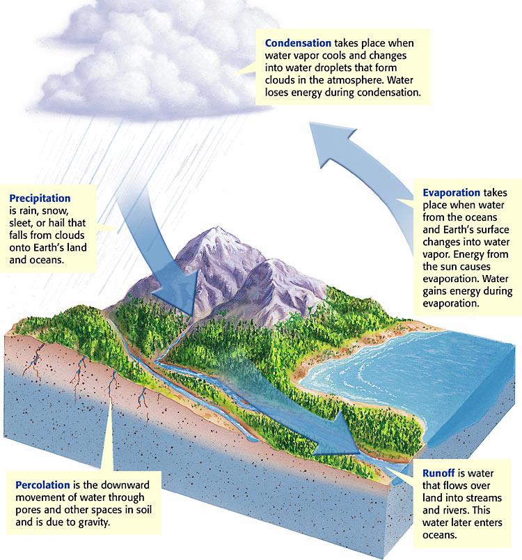
2 Figure 1 The Grand Canyon is located in northwestern Arizona. The canyon formed over millions of years as running water eroded the rock layers. Rivers: Agents of Erosion Six million years ago, the area now known as the Grand Canyon was nearly as flat as a pancake. Tectonic uplift raised the land, and water running downhill became the Colorado River. The Colorado River cut down into the rock and formed the Grand Canyon over millions of years through the process of erosion. Erosion is the process by which wind, water, ice, and gravity move soil and sediment from one place to another. Rivers, such as the Colorado River, are agents of erosion that shape Earth s landscape. Because of erosion caused by water, the Grand Canyon is now about 1.6 km deep and 446 km long. In this section, you will learn about stream development and river systems. You will also learn about factors that affect the rate of stream erosion. landscape? What is erosion, and how does it shape Earth s The Water Cycle Have you ever wondered where the water in rivers comes from? This water is part of the water cycle. The water cycle, shown in Figure 2, is the continuous movement of water between the atmosphere, the land, and the oceans. The major source of energy that drives the water cycle is the sun. Figure 2 The Water Cycle
3
4 Describe the water cycle. River Systems The next time you take a shower, notice that individual drops of water join to become small streams. These streams join other small streams and form larger streams. Eventually, all of the water flows down the drain. Every time you shower, you make a model of a river system. A river system is a network of streams and rivers that drain an area of its runoff. A stream that flows into a lake or into a larger stream is called a tributary. river system. Describe the difference between a tributary and a Watersheds and Divides River systems are divided into regions called watersheds. A watershed is the area of land that is drained by a river system. Watersheds vary in size. The largest watershed in the United States is the Mississippi River watershed. This watershed has hundreds of tributaries. These tributaries extend from the Rocky Mountains, in the West, to the Appalachian Mountains, in the East. A main stream that drains a large watershed and has many tributaries is called a river. The image in Figure 3 shows that the Mississippi River watershed covers more than one-third of the United States. Other major watersheds are the Columbia River, the Rio Grande, and the Colorado River watersheds. Watersheds are separated from each other by an area of higher ground called a divide.

5 Figure 3 The Continental Divide runs through the Rocky Mountains. It separates the watersheds that flow into the Atlantic Ocean and the Gulf of Mexico from those that flow into the Pacific Ocean. The Mississippi River watershed is shown in light green. Stream Erosion A stream forms as water erodes soil and rock to make a channel. A channel is the path that a stream follows. As the stream continues to erode rock and soil, the channel

6 gets wider and deeper. Over time, tributaries join the main channel. The increased water flow from the tributaries causes the stream to become longer and wider. Gradient Figure 4 shows two rivers that have very different gradients. Gradient is the measure of the change in elevation over a certain distance. The water in a stream or river that has a high gradient moves very rapidly. This rapid water flow gives the stream or river a lot of energy to erode rock and soil. A river or stream that has a low gradient has less energy for erosion. Figure 4 California Rivers That Have Different Gradients channels? How does gradient affect the erosion of stream Discharge The amount of water that a stream or river carries in a given amount of time is called discharge. The discharge of a stream increases when a major storm occurs or when warm weather rapidly melts snow. As the stream s discharge increases, the water s speed and erosive energy increase. The amount of solid material that the stream can carry also increases.
7 Load The materials carried by a stream are called the stream s load. The three types of load are shown in Figure 5. The size of the particles in a stream s load is affected by the stream s speed. Fast-moving streams can carry large particles. Rocks and pebbles bounce and scrape along the bottom and sides of the stream bed. Thus, a stream that has a load of large particles has a high rate of erosion. Streams that move more slowly carry smaller particles and have less erosive energy. Figure 5 Three Types of Load

8 How does load affect rates of erosion?
9 Describing Rivers William Morris Davis was a geomorphologist who studied how rivers shape the landscape. His studies of rivers in the Appalachian Mountains helped him develop a model to describe the stages of river development. In his model, rivers went through a series of stages. Davis described rivers as evolving from a youthful stage to an old-age stage. He thought that all rivers eroded in the same way and at the same rate. Today, scientists support a model that differs from Davis s model. Because materials erode at different rates, one river may develop more quickly than another river does. Many factors, such as climate, local geology, gradient, and load, influence the development of a river. Scientists no longer use Davis s model to explain river development. But they still use many of his terms to describe a river. These terms describe a river s general features, not a river s actual age. Youthful Rivers A youthful river erodes its channel deeper rather than wider. Its channel is narrow and straight. The river tumbles over rocks in rapids and waterfalls. Youthful rivers have very few tributaries. These rivers flow quickly because they have steep gradients. Many youthful rivers have steep gradients because the areas that these rivers drain have been tectonically uplifted. A youthful river in Wyoming is shown in Figure 6.

10 Figure 6 This youthful river is located in Yellowstone National Park in Wyoming. Rapids and falls exist where the river flows over hard, resistant rock. Describe a youthful river. Mature Rivers Unlike a youthful river, a mature river erodes its channel wider rather than deeper. The gradient of a mature river is not as steep as that of a youthful river. Therefore, a mature river has fewer falls and rapids. A mature river is fed by many tributaries. Because of its large watershed, a mature river has more discharge than a youthful river does. A mature river is shown in Figure 7. Notice that a mature river tends to curve back and forth. These curves or bends in the river s channel are called meanders.

11 Figure 7 A mature river, such as this one in the Amazon basin of Peru, curves back and forth. Describe the difference between youthful rivers and mature rivers in terms of how these rivers erode their channels. Rejuvenated Rivers A rejuvenated (ri JOO vuh NAYT ed) river forms where the land has been raised by tectonic activity. When land rises, the river s gradient becomes steeper and the river flows more quickly. This rapid water flow allows the river to cut more deeply into the valley floor. Steplike formations called terraces commonly form on both sides of a stream valley because of reju venation, as Figure 8 shows.

12 Figure 8 The rejuvenated river above is located in Canyonlands National Park in Utah. Old Rivers An old river has a low gradient, so it has little erosive energy. Instead of widening and deepening its banks, the river deposits rock and soil in and along its channel. An old river has wide, flat floodplains, or river valleys, and many bends. An old river also has fewer tributaries than a mature river does. An old river has fewer tributaries because its smaller tributaries have joined together. An old river commonly forms an oxbow lake, such as the one shown in Figure 9. An oxbow lake forms when the strip of land that separates parts of a meander is eroded. This process shortens the river s length.

13 Figure 9 This old river is located in New Zealand. Section Summary Rivers shape Earth s landscape through the process of erosion. The sun is the major source of energy that drives the water cycle. A river system is made up of a network of streams and rivers. A watershed is a region that collects runoff water that then becomes part of a river system that drains into a lake or the ocean. Gradient affects the speed at which water flows in a stream. The higher the gradient, the faster the water flows. Water that flows rapidly has a lot of energy for eroding soil and rock. When a stream s discharge increases, the stream s erosive energy also increases.
14 A stream can carry eroded particles as bed load, suspended load, or dissolved load. A stream that has a load of large particles has a high rate of erosion. A river can be described as youthful, mature, old, or rejuvenated based on its characteristics.
WEATHERING, EROSION, and DEPOSITION REVIEW
 WEATHERING, EROSION, and DEPOSITION REVIEW Weathering: The breaking up of rock from large particles to smaller particles. a) This Increases surface area of the rock which speeds the rate of chemical weathering.
WEATHERING, EROSION, AND DEPOSITION PRACTICE TEST. Which graph best shows the relative stream velocities across the stream from A to B?
 NAME DATE WEATHERING, EROSION, AND DEPOSITION PRACTICE TEST 1. The diagram below shows a meandering stream. Measurements of stream velocity were taken along straight line AB. Which graph best shows the
Earth Science Landforms, Weathering, and Erosion Reading Comprehension. Landforms, Weathering, and Erosion
 Reading Comprehension Name 1 How many people have been to the Rocky Mountains or the Grand Canyon? When people go to visit these natural wonders, they may not realize that it took millions of years for
Earth Science. River Systems and Landforms GEOGRAPHY 1710. The Hydrologic Cycle. Introduction. Running Water. Chapter 14.
 Earth Science GEOGRAPHY 1710 River Systems and Landforms DAVID R. SALLEE Robert W. Christopherson Charlie Thomsen Chapter 14 Introduction Rivers and streams are dynamic systems that continually adjust
Glacier Erosion Notes
 Name Date ES per Mr. Landsman Glacier Erosion Notes Erosion: the of weathered material. Glacier: A large mass of ice and snow that exists year-round and moves under the influence of. Evidence for Glacier
Rapid Changes in Earth s Surface
 TEKS investigate rapid changes in Earth s surface such as volcanic eruptions, earthquakes, and landslides Rapid Changes in Earth s Surface Constant Changes Earth s surface is constantly changing. Wind,
8/18/2014. Chapter 9: Erosion and Deposition. Section 1 (Changing Earth s Surface) 8 th Grade. Weathering
 8 th Grade. Weathering") Section 1 (Changing Earth s Surface) Weathering the chemical and physical processes that break down rock at Earth s surface Chapter 9: Erosion and Deposition 8 th Grade Mechanical weathering when rock
Section 1 (Changing Earth s Surface) Weathering the chemical and physical processes that break down rock at Earth s surface Chapter 9: Erosion and Deposition 8 th Grade Mechanical weathering when rock
Tectonic plates have different boundaries.
 KEY CONCEPT Plates move apart. BEFORE, you learned The continents join and break apart The sea floor provides evidence that tectonic plates move The theory of plate tectonics helps explain how the plates
The Earth System. The geosphere is the solid Earth that includes the continental and oceanic crust as well as the various layers of Earth s interior.
 The Earth System The atmosphere is the gaseous envelope that surrounds Earth. It consists of a mixture of gases composed primarily of nitrogen, oxygen, carbon dioxide, and water vapor. The atmosphere and
GY301 Geomorphology Fluvial Erosion Landforms
 Introduction Running water is by far the most important erosional agent on Earth. Even in arid climates, it is the primary agent of erosion. This is evident from the abundance of stream beds found throughout
Igneous rocks formed when hot molten material (magma) cools and hardens (crystallizes).
 cools and hardens (crystallizes).") Objectives You will learn about how the land of North Dakota was formed. Introduction North Dakota is a wonderful place to live. Have you ever though about how it was formed? To answer that question, you
Objectives You will learn about how the land of North Dakota was formed. Introduction North Dakota is a wonderful place to live. Have you ever though about how it was formed? To answer that question, you
1. You are about to begin a unit on geology. Can anyone tell me what geology is? The study of the physical earth I.
 PLATE TECTONICS ACTIVITY The purpose of this lab is to introduce the concept of plate tectonics and the formation of mountains. Students will discuss the properties of the earth s crust and plate tectonics.
Georgia Performance Standards Framework for Science Grade 6. Unit Organizer: Water in Earth s Processes. (Approximate Time: 5-6 Weeks)
") The following instructional plan is part of a GaDOE collection of Unit Frameworks, Performance Tasks, examples of Student Work, and Teacher Commentary. Many more GaDOE approved instructional plans are
The following instructional plan is part of a GaDOE collection of Unit Frameworks, Performance Tasks, examples of Student Work, and Teacher Commentary. Many more GaDOE approved instructional plans are
5-Minute Refresher: WEATHERING AND EROSION
 5-Minute Refresher: WEATHERING AND EROSION Weathering and Erosion Key Ideas Weathering is the wearing away of the surface of rock, soil, and minerals into smaller pieces. Example of weathering: Wind and
Geomorphology is the Study of Landforms. Usually by Erosion, Transportation and Deposition
 Geomorphology is the Study of Landforms and the Processes that t Create Them, Usually by Erosion, Transportation and Deposition Fluvial = running water, rivers and floodplains Glacial = flowing ice in
Rocks and Minerals What is right under your feet?
 Rocks and Minerals What is right under your feet? Name: 1 Before you start What do you already know? What is the difference between a rock and a mineral? What are the three categories of rocks? 1. 2. 3.
Ride the Rock Cycle. Suggested Goals: Students will gain an understanding of how a rock can move through the different stages of the rock cycle.
 Illinois State Museum Geology Online http://geologyonline.museum.state.il.us Ride the Rock Cycle Grade Level: 5 6 Purpose: To teach students that the rock cycle, like the water cycle, has various stages
2 Wind Erosion and Deposition
 CHAPTER 3 2 Wind Erosion and Deposition SECTION Agents of Erosion and Deposition BEFORE YOU READ After you read this section, you should be able to answer these questions: How can wind erosion shape the
Chapter Overview. Bathymetry. Measuring Bathymetry. Echo Sounding Record. Measuring Bathymetry. CHAPTER 3 Marine Provinces
 Chapter Overview CHAPTER 3 Marine Provinces The study of bathymetry charts ocean depths and ocean floor topography. Echo sounding and satellites are efficient bathymetric tools. Most ocean floor features
The concepts developed in this standard include the following: Oceans cover about 70% of the surface of the Earth.
 Name Date Grade 5 SOL 5.6 Review Oceans Made by SOLpass - www.solpass.org solpass100@comcast.net Reproduction is permitted for SOLpass subscribers only. The concepts developed in this standard include
Deserts, Wind Erosion and Deposition
 Deserts, Wind Erosion and Deposition By definition, a desert has less than 10 in (25 cm) of precipitation per year. Deserts occur at 30 o and 60 o in regions of descending air. Deserts can be hot or cold.
The rock cycle. Introduction. What are rocks?
 The rock cycle This Revision looks at the three types of rock: sedimentary, igneous and metamorphic. It looks at how they are formed, the weathering of rocks and the way one form of rock turns into another,
Flash Flood Science. Chapter 2. What Is in This Chapter? Flash Flood Processes
 Chapter 2 Flash Flood Science A flash flood is generally defined as a rapid onset flood of short duration with a relatively high peak discharge (World Meteorological Organization). The American Meteorological
Rocks and Plate Tectonics
 Name: Class: _ Date: _ Rocks and Plate Tectonics Multiple Choice Identify the choice that best completes the statement or answers the question. 1. What is a naturally occurring, solid mass of mineral or
Grade 4 Standard 1 Unit Test Water Cycle. Multiple Choice. 1. Where is most water found on Earth? A. in glaciers B. in lakes C. in rivers D.
 Grade 4 Standard 1 Unit Test Water Cycle Multiple Choice 1. Where is most water found on Earth? A. in glaciers B. in lakes C. in rivers D. in oceans 2. What source of energy evaporates the most water from
NATURAL REGIONS OF KENTUCKY
 NATURAL WONDERS As you travel around Kentucky taking pictures, you are excited by what you see. Kentucky offers diverse and amazing sights. The Six Regions In the West, you see the Mississippi River, the
Southern AER Atmospheric Education Resource
 Southern AER Atmospheric Education Resource Vol. 9 No. 5 Spring 2003 Editor: Lauren Bell In this issue: g Climate Creations exploring mother nature s remote control for weather and Climate. g Crazy Climate
6. Base your answer to the following question on the graph below, which shows the average monthly temperature of two cities A and B.
 1. Which single factor generally has the greatest effect on the climate of an area on the Earth's surface? 1) the distance from the Equator 2) the extent of vegetative cover 3) the degrees of longitude
Weathering, Erosion, and Soils. Weathering and Erosion. Weathering and Erosion
 Weathering, Erosion, and Soils 1 The Grand Canyon, a landscape shaped by weathering and erosion 2 Weathering vs. erosion Types of weathering Physical Chemical Rates of weathering and erosion Climate Rock
Water Cycle Unit Test
 Name: Multiple Choice (2 pts each): 1. What is the source of energy for all parts of the water cycle? A. Wind B. The Ocean C. Soil D. The Sun 2. Which of the following processes would result in water pollution?
Introduction and Origin of the Earth
 Page 1 of 5 EENS 1110 Tulane University Physical Geology Prof. Stephen A. Nelson Introduction and Origin of the Earth This page last updated on 30-Jul-2015 Geology, What is it? Geology is the study of
Small Dam Hazard Assessment Inventory
 Small Dam Hazard Assessment Inventory What would happen if your dam were to fail? This is a question that most dam owners hope they will never have to answer. However it is a question you, as a responsible
How Did These Ocean Features and Continental Margins Form?
 298 10.14 INVESTIGATION How Did These Ocean Features and Continental Margins Form? The terrain below contains various features on the seafloor, as well as parts of three continents. Some general observations
6.E.2.2 Plate Tectonics, Earthquakes and Volcanoes
 Name: Date: 1. The road shown below was suddenly broken by a natural event. 3. The convergence of two continental plates would produce Which natural event most likely caused the crack in the road? island
Water & Climate Review
 Water & Climate Review 1. The cross section below shows the direction of air flowing over a mountain. Points A and B are at the same elevation on opposite sides of the mountain. 4. The graph below shows
CLIMATE, WATER & LIVING PATTERNS THINGS
 CLIMATE, WATER & LIVING PATTERNS NAME THE SIX MAJOR CLIMATE REGIONS DESCRIBE EACH CLIMATE REGION TELL THE FIVE FACTORS THAT AFFECT CLIMATE EXPLAIN HOW THOSE FACTORS AFFECT CLIMATE DESCRIBE HOW CLIMATES
Climates are described by the same conditions used to describe
 58 The Causes of Climate R E A D I N G Climates are described by the same conditions used to describe weather, such as temperature, precipitation, and wind. You now know that oceans have an important effect
5 th Grade Science Vocabulary Words
 5 th Grade Science Vocabulary Words abiotic factor A nonliving part of an ecosystem. acceleration Change in velocity with respect to time. action The force one object applies to a second, as in Newton
BASIC LESSON Objective(s)
") [Geology - Landforms] [K-1: Basic] [Grades 2-3: Advanced] BACKGROUND Landforms are natural features of the Earth's surface. They are created by the movement of ice or water, earthquakes, lava flows, volcanoes,
[Geology - Landforms] [K-1: Basic] [Grades 2-3: Advanced] BACKGROUND Landforms are natural features of the Earth's surface. They are created by the movement of ice or water, earthquakes, lava flows, volcanoes,
Course Plan Day 1: Introduction and Overview Hydrology & Fluvial Geomorphology Day 2: Fieldwork on the Braid Burn Alan Jones
 Course Plan Day 1: Introduction and Overview Hydrology & Fluvial Geomorphology Alan Jones E:mail: Alan.Jones@ed.ac.uk Water cycle Globally & Locally River shapes and forms River behaviour Closer look at
WHERE DOES THE WATER GO IN THE WATER CYCLE?
 WHERE DOES THE WATER GO IN THE WATER CYCLE? OBJECTIVES Identify the water cycle as a system that is a combination of systems Describe each process in the water cycle, including the changes in state (if
All sediments have a source or provenance, a place or number of places of origin where they were produced.
 Sedimentary Rocks, Processes, and Environments Sediments are loose grains and chemical residues of earth materials, which include things such as rock fragments, mineral grains, part of plants or animals,
ES Chapter 10 Review. Name: Class: Date: Multiple Choice Identify the choice that best completes the statement or answers the question.
 Name: Class: Date: ES Chapter 10 Review Multiple Choice Identify the choice that best completes the statement or answers the question. 1. Scientists used the pattern of alternating normal and reversed
Plate Tectonics Short Study Guide
 Name: Class: Date: Plate Tectonics Short Study Guide Multiple Choice Identify the letter of the choice that best completes the statement or answers the question. 1. The existence of coal beds in Antarctica
Stream Rehabilitation Concepts, Guidelines and Examples. Objectives. Pierre Y. Julien. Three Laws of Stream Restoration
 Stream Rehabilitation Concepts, Guidelines and Examples Pierre Y. Julien Wuhan 2005 Objectives Part I - Stream restoration and rehabilitation: 1. Present and discuss important concepts, laws, criteria
Hoover Dam: Taming the Colorado River and Powering Millions
 06 March 2012 MP3 at voaspecialenglish.com Hoover Dam: Taming the Colorado River and Powering Millions USBR BOB DOUGHTY: This is Bob Doughty. STEVE EMBER: And this is Steve Ember with EXPLORATIONS in VOA
The Water Cycle Now You See It, Now You Don t
 The Water Cycle Now You See It, Now You Don t Unit: Salinity Patterns & the Water Cycle l Grade Level: Elementary l Time Required: Introduction - 30 min. - Activity as groups 45min Wrap Up 20 min l Content
Continents join together and split apart.
 KEY CONCEPT Continents change position over time. BEFORE, you learned Earth s main layers are the core, the mantle, and the crust The lithosphere and asthenosphere are the topmost layers of Earth The lithosphere
Ocean Floor Continental Slope Begins at the Continental Shelf Very sharp drop to depths over 2 miles Covered with thick layers of sand, mud, and rocks
 Ocean Floor Continental Shelf Begins at the shoreline Gently slopes underwater Average depth of 430 feet Thick layers of sand, mud, and rocks The beach is part of the Continental Shelf Ocean Floor Continental
Plate Tectonics: Ridges, Transform Faults and Subduction Zones
 Plate Tectonics: Ridges, Transform Faults and Subduction Zones Goals of this exercise: 1. review the major physiographic features of the ocean basins 2. investigate the creation of oceanic crust at mid-ocean
Geography. Geography B. Exemplar Candidate Work Rivers GCSE 2012. Version 1 November 2012
 Geography GCSE 2012 Geography B Exemplar Candidate Work Rivers Version 1 November 2012 www.ocr.org.uk/gcse2012 CONTENTS Question 3 Exemplar Candidate Work 4 Assessor Comments 21 GCSE Geography Bexemplar
Module 2 Educator s Guide Investigation 3
 What similar physical processes occur on both Earth and Mars? Investigation Overview Could life exist on Mars? This is a question that humans have wondered about for centuries. What physical processes
not to be republished NCERT MAJOR LANDFORMS OF THE EARTH
 6 You must have seen some of the landform features as shown in the Figure 6.1 below. You will notice that the surface of the earth is not the same everywhere. The earth has an infinite variety of landforms.
CITY UTILITIES DESIGN STANDARDS MANUAL
 CITY UTILITIES DESIGN STANDARDS MANUAL Book 2 (SW) SW9 June 2015 SW9.01 Purpose This Chapter provides information for the design of open channels for the conveyance of stormwater in the City of Fort Wayne.
PRECIPITATION AND EVAPORATION
 PRECIPITATION AND EVAPORATION OBJECTIVES Use historical data to analyze relationships between precipitation, evaporation and stream flow in the San Antonio River Basin TOPICS Water cycle Precipitation
What are Rocks??? Rocks are the most common material on Earth. They are a naturally occurring collection of one or more minerals.
 The Rock Cycle What are Rocks??? Rocks are the most common material on Earth. They are a naturally occurring collection of one or more minerals. The Rock Cycle a cycle that continuously forms and changes
The Fossil Record and Geologic Time Scale
 Two Conceptions of Earth History: Catastrophism Assumption: Great Effects Require Great Causes Earth History Dominated by Violent Events Uniformitarianism Assumption: We Can Use Cause And Effect to Determine
1 Branches of Earth Science
 CHAPTER 1 1 Branches of Earth Science SECTION The World of Earth Science BEFORE YOU READ After you read this section, you should be able to answer these questions: What are the four major branches of Earth
The Ice Age By: Sue Peterson
 www.k5learning.com Objective sight words (pulses, intermittent, isotopes, chronicle, methane, tectonic plates, volcanism, configurations, land-locked, erratic); concepts (geological evidence and specific
Study Guide Questions Earth Structure and Plate Tectonics
 Study Guide Questions Earth Structure and Plate Tectonics What evidence did Alfred Wegener present in 1912 to support the idea of continental drift? Why did most geologists at the time dismiss Wegener
4. Plate Tectonics II (p. 46-67)
") 4. Plate Tectonics II (p. 46-67) Seafloor Spreading In the early 1960s, samples of basaltic ocean crust were dredged up from various locations across the ocean basins. The samples were then analyzed to
4. Plate Tectonics II (p. 46-67) Seafloor Spreading In the early 1960s, samples of basaltic ocean crust were dredged up from various locations across the ocean basins. The samples were then analyzed to
The Next Generation Science Standards (NGSS) Correlation to. EarthComm, Second Edition. Project-Based Space and Earth System Science
 Correlation to. EarthComm, Second Edition. Project-Based Space and Earth System Science") The Next Generation Science Standards (NGSS) Achieve, Inc. on behalf of the twenty-six states and partners that collaborated on the NGSS Copyright 2013 Achieve, Inc. All rights reserved. Correlation to,
The Next Generation Science Standards (NGSS) Achieve, Inc. on behalf of the twenty-six states and partners that collaborated on the NGSS Copyright 2013 Achieve, Inc. All rights reserved. Correlation to,
The Water Cycle. 4 th Grade Pre-Visit Activity #1
 th Grade Pre-Visit Activity # The Water Cycle Overview Objectives Subjects Earth s water molecules circulate among air, plants, animals, and soil by way of the water cycle. This activity uses a game to
Section 1 The Earth System
 Section 1 The Earth System Key Concept Earth is a complex system made up of many smaller systems through which matter and energy are continuously cycled. What You Will Learn Energy and matter flow through
SECOND GRADE PLATE TECTONICS 1 WEEK LESSON PLANS AND ACTIVITIES
 SECOND GRADE PLATE TECTONICS 1 WEEK LESSON PLANS AND ACTIVITIES PLATE TECTONIC CYCLE OVERVIEW OF SECOND GRADE VOLCANOES WEEK 1. PRE: Investigating the parts of a volcano. LAB: Comparing the parts of a
Chapter 8: Plate Tectonics -- Multi-format Test
 Name: Class: Date: ID: A Chapter 8: Plate Tectonics -- Multi-format Test Modified True/False Indicate whether the statement is true or false. If false, change the identified word or phrase to make the
Georgia Performance Standards Framework for Natural Disasters 6 th Grade
 The following instructional plan is part of a GaDOE collection of Unit Frameworks, Performance Tasks, examples of Student Work, and Teacher Commentary. Many more GaDOE approved instructional plans are
THE PLANT KINGDOM: THE WATER CYCLE
 THE PLANT KINGDOM: THE WATER CYCLE Material: The Water Cycle Nomenclature The Water cycle Model Water Ice Heat Source (lamp with a clamp) Tables Presentation 1: Key Experience 1. Say, Today we are going
SIXTH GRADE WEATHER 1 WEEK LESSON PLANS AND ACTIVITIES
 SIXTH GRADE WEATHER 1 WEEK LESSON PLANS AND ACTIVITIES WATER CYCLE OVERVIEW OF SIXTH GRADE WATER WEEK 1. PRE: Evaluating components of the water cycle. LAB: Experimenting with porosity and permeability.
Plate Tectonics Web-Quest
 Plate Tectonics Web-Quest Part I: Earth s Structure. Use the following link to find these answers: http://www.learner.org/interactives/dynamicearth/structure.html 1. Label the layers of Earth in the diagram
LEARNING THE LANDFORMS Grade Level: Third Presented by: Elizabeth Turcott, Endeavor Charter Academy, Springfield, Michigan Length of Unit: 14 lessons
 LEARNING THE LANDFORMS Grade Level: Third Presented by: Elizabeth Turcott, Endeavor Charter Academy, Springfield, Michigan Length of Unit: 14 lessons I. ABSTRACT This unit develops an understanding of
How Do Oceans Affect Weather and Climate?
 How Do Oceans Affect Weather and Climate? In Learning Set 2, you explored how water heats up more slowly than land and also cools off more slowly than land. Weather is caused by events in the atmosphere.
Advice For the multiple-choice questions, completely fill in the circle alongside the appropriate answer(s).
.") SPECIMEN ASSESSMENT MATERIAL GCSE GEOGRAPHY Paper 1 Living with the physical environment Specimen Materials For this paper you must have: a pencil a ruler. Time allowed: 1 hour 30 minutes Instructions
SPECIMEN ASSESSMENT MATERIAL GCSE GEOGRAPHY Paper 1 Living with the physical environment Specimen Materials For this paper you must have: a pencil a ruler. Time allowed: 1 hour 30 minutes Instructions
Watershed Delineation
 ooooo Appendix D: Watershed Delineation Department of Environmental Protection Stream Survey Manual 113 Appendix D: Watershed Delineation Imagine a watershed as an enormous bowl. As water falls onto the
Traveling on the Water Cycle
 Traveling on the Water Cycle 40- to 1-2 50-minute sessions ACTIVITY OVERVIEW 62 M OD E L I N G Students simulate traveling with water molecules through the water cycle, beginning in their own town. After
Name Period 4 th Six Weeks Notes 2015 Weather
 Name Period 4 th Six Weeks Notes 2015 Weather Radiation Convection Currents Winds Jet Streams Energy from the Sun reaches Earth as electromagnetic waves This energy fuels all life on Earth including the
There are many ways of differentiating the activity and tweaking it to suit the needs of pupils, these notes outline some possible strategies:
 How the mystery works There are many ways of differentiating the activity and tweaking it to suit the needs of pupils, these notes outline some possible strategies: The cards (see below) should be copied,
Earthquakes and Plate Boundaries Deborah Jordan and Samuel Spiegel
 Earthquakes and Plate Boundaries Deborah Jordan and Samuel Spiegel Jordan, Deborah and Spiegel, Samuel: Learning Research Development Center, University of Pittsburgh. Earthquakes and Plate Boundaries.
Plate Tectonics. Hi, I am Zed and I am going to take you on a trip learning about Plate Tectonics. And I am Buddy Zed s mascot
 Plate Tectonics Hi, I am Zed and I am going to take you on a trip learning about Plate Tectonics And I am Buddy Zed s mascot Continental Drift Alfred Wegener proposed that continents were not always where
California Standards Grades 9 12 Boardworks 2009 Science Contents Standards Mapping
 California Standards Grades 912 Boardworks 2009 Science Contents Standards Mapping Earth Sciences Earth s Place in the Universe 1. Astronomy and planetary exploration reveal the solar system s structure,
Layers of the Earth s Interior
 Layers of the Earth s Interior 1 Focus Question How is the Earth like an ogre? 2 Objectives Explain how geologists have learned about the interior of the Earth. Describe the layers of the Earth s interior.
KINDERGARTEN WATER 1 WEEK LESSON PLANS AND ACTIVITIES
 KINDERGARTEN WATER 1 WEEK LESSON PLANS AND ACTIVITIES WATER CYCLE OVERVIEW OF KINDERGARTEN WEEK 1. PRE: Defining the states of matter. LAB: Discovering the properties of water. POST: Analyzing the water
PLATE TECTONICS EXERCISE (Modified from North Seattle Community College online exercise)
") PLATE TECTONICS EXERCISE (Modified from North Seattle Community College online exercise) Introduction: As discussed in our textbook, the speed at which tectonic plates move has been calculated in several
PLATE TECTONICS EXERCISE (Modified from North Seattle Community College online exercise) Introduction: As discussed in our textbook, the speed at which tectonic plates move has been calculated in several
Related Standards and Background Information
 Related Standards and Background Information Earth Patterns, Cycles and Changes This strand focuses on student understanding of patterns in nature, natural cycles, and changes that occur both quickly and
GLOSSARY OF TERMS CHAPTER 11 WORD DEFINITION SOURCE. Leopold
 CHAPTER 11 GLOSSARY OF TERMS Active Channel The channel that contains the discharge Leopold where channel maintenance is most effective, sediment are actively transported and deposited, and that are capable
Missouri Regions Shaped by Land Forms and Geology
 Missouri Regions Shaped by Land Forms and Geology Lesson Abstract Summary: MO GLE: Subject Areas: The students will use various resources to compare and contrast the geology of each Missouri region to
Map Patterns and Finding the Strike and Dip from a Mapped Outcrop of a Planar Surface
 Map Patterns and Finding the Strike and Dip from a Mapped Outcrop of a Planar Surface Topographic maps represent the complex curves of earth s surface with contour lines that represent the intersection
1. A student found a sample of a solid material that was gray, shiny and made of all the same material. What category does this sample best fit?
 Grade 4 Standard 3 Unit Test A Earth Materials Multiple Choice 1. A student found a sample of a solid material that was gray, shiny and made of all the same material. What category does this sample best
Mixtures. reflect. How is seawater different from pure water? How is it different from rocky soil?
 reflect Everything around us is made out of tiny bits of matter. These particles may combine in different ways to produce new materials. Sometimes we need to separate the parts of a material. If we know
Freely Falling Objects
 Freely Falling Objects Physics 1425 Lecture 3 Michael Fowler, UVa. Today s Topics In the previous lecture, we analyzed onedimensional motion, defining displacement, velocity, and acceleration and finding
Aristotelian Physics. Aristotle's physics agrees with most people's common sense, but modern scientists discard it. So what went wrong?
 Aristotelian Physics Aristotle's physics agrees with most people's common sense, but modern scientists discard it. So what went wrong? Here's what Aristotle said: Aristotelian Physics Aristotle s classification
FROM SEDIMENT INTO SEDIMENTARY ROCK. Objectives. Sediments and Sedimentation
 FROM SEDIMENT INTO SEDIMENTARY ROCK Objectives Identify three types of sediments. Explain where and how chemical and biogenic sediments form. Explain three processes that lead to the lithification of sediments.
TECTONICS ASSESSMENT
 Tectonics Assessment / 1 TECTONICS ASSESSMENT 1. Movement along plate boundaries produces A. tides. B. fronts. C. hurricanes. D. earthquakes. 2. Which of the following is TRUE about the movement of continents?
Floodplain Connectivity in Restoration Design
 Floodplain Connectivity in Restoration Design 2015 Symposium on Restoration in a Contaminated Environment: Lessons Learned and Challenges in Moving Forward Part II April 2015 Karin Boyd Applied Geomorphology,
Curriculum Map Earth Science - High School
 September Science is a format process to use Use instruments to measure Measurement labs - mass, volume, to observe, classify, and analyze the observable properties. density environment. Use lab equipment
2. The map below shows high-pressure and low-pressure weather systems in the United States.
 1. Which weather instrument has most improved the accuracy of weather forecasts over the past 40 years? 1) thermometer 3) weather satellite 2) sling psychrometer 4) weather balloon 6. Wind velocity is
6 th Grade Science Assessment: Weather & Water Select the best answer on the answer sheet. Please do not make any marks on this test.
 Select the be answer on the answer sheet. Please do not make any marks on this te. 1. Weather is be defined as the A. changes that occur in cloud formations from day to day. B. amount of rain or snow that
The Dynamic Crust 2) EVIDENCE FOR CRUSTAL MOVEMENT
 EVIDENCE FOR CRUSTAL MOVEMENT") The Dynamic Crust 1) Virtually everything you need to know about the interior of the earth can be found on page 10 of your reference tables. Take the time to become familiar with page 10 and everything
The Dynamic Crust 1) Virtually everything you need to know about the interior of the earth can be found on page 10 of your reference tables. Take the time to become familiar with page 10 and everything
Name: Period: # Plate Tectonics. Journey to the center of the Earth
 Plate Tectonics Journey to the center of the Earth Use pages 124 129 to answer the following questions. Exploring Inside Earth (p. 125-126) 1. What are the two main types of evidence that Geologist use
Unit Template for NGSS Units of Study (Jean Ward 2015)
") Unit Template for NGSS Units of Study (Jean Ward 2015) Title of Unit Earth s Systems Grade Level 5 Curriculum Area Earth Science Time Frame 3-4 Weeks Developed by Patricia L. Preseault Desired Results
Unit Template for NGSS Units of Study (Jean Ward 2015) Title of Unit Earth s Systems Grade Level 5 Curriculum Area Earth Science Time Frame 3-4 Weeks Developed by Patricia L. Preseault Desired Results